Sanpete Sanitary Landfill Cooperative Chester Class II ... · Each input parameter for the Chester...
26
Sanpete Sanitary Landfill Cooperative Chester Class II Closed Landfill Permit Application December 1, 2004, Page 36 Revised, June 6, 2005 Percent Sand Percent Silt Percent Clay Percent Sand, Excluding Gravel* Percent Silt, Excluding Gravel* Percent Clay, Excluding Gravel* USDA Classification Hydraulic Conductivity as determined on remolded samples * * 19.00 42.00 30.00 20.90 46.20 33.00 Clay Loam 7.1X10"^ cm/second (compacted to 95% of maximum dry density) 29.00 29.00 24.00 35.40 35.40 29.30 Clay Loam 2.9 X 10 ^cm/second (compacted to 96.3% of maximum dry density) * In the USDA system oftextural classification soil texture is determined using only the weight proportion of soil particles less than 2 mm in diameter as determined from laboratory particle- size distribution analyses (gradation). Coarser particles are considered "rock fragments, " and are not utilized for 'fine earth " soil classification. ** Analyses of hydraulic conductivity for samples compacted to 95% of maximum dry density rangedfrom 3.0 X KTUo 7.1 X 1 0 ' cm/second Fine-grained soils from five feet below ground level (BGL) along with gravelly sand soils recovered from depths of 10 feet and 20 feet BGL were combined in Bingham's Composite Sample No. 1 and tested for permeability. These combined soils had the slowest infiltration rates of Bingham's four permeability tests. Three other permeability tests were conducted on coarser materials from 25 feet BGL or deeper. 14.4 Soil Properties Determined by Tri-State Testing Laboratories, Inc. Additional soil samples were recovered from an open trench at the northem edge ofthe existing landfill prism. The trench was about 28 feet deep. Soils in the first ten feet below ground level are mostly silt and clay, with only traces of gravel. Below 10 feet silty. clayey, sand and gravel are predominant. All soils are tan and dr}' down to about 25 feet. Soils below GARY PLAYER VENTURES WASTE MANAGEMENT CONSULTANTS
Transcript of Sanpete Sanitary Landfill Cooperative Chester Class II ... · Each input parameter for the Chester...

Sanpete Sanitary Landfill Cooperative Chester Class I I Closed Landfill Permit Application December 1, 2004, Page 36
Revised, June 6, 2005
Percent Sand
Percent Silt
Percent Clay
Percent Sand, Excluding Gravel*
Percent Silt, Excluding Gravel*
Percent Clay, Excluding Gravel*
USDA Classification
Hydraulic Conductivity as determined on remolded samples * *
19.00
42.00
30.00
20.90
46.20
33.00
Clay Loam
7.1X10"^ cm/second (compacted to 95% of maximum dry density)
29.00
29.00
24.00
35.40
35.40
29.30
Clay Loam
2.9 X 10 ^cm/second (compacted to 96.3% of maximum dry density)
* In the USDA system oftextural classification soil texture is determined using only the weight proportion of soil particles less than 2 mm in diameter as determined from laboratory particle-size distribution analyses (gradation). Coarser particles are considered "rock fragments, " and are not utilized for 'fine earth " soil classification.
** Analyses of hydraulic conductivity for samples compacted to 95% of maximum dry density ranged from 3.0 X KTUo 7.1 X 1 0 ' cm/second
Fine-grained soils from five feet below ground level (BGL) along with gravelly sand soils recovered from depths of 10 feet and 20 feet BGL were combined in Bingham's Composite Sample No. 1 and tested for permeability. These combined soils had the slowest infiltration rates of Bingham's four permeability tests. Three other permeability tests were conducted on coarser materials from 25 feet BGL or deeper.
14.4 Soil Properties Determined by Tri-State Testing Laboratories, Inc. Additional soil samples were recovered from an open trench at the northem edge ofthe existing landfill prism. The trench was about 28 feet deep. Soils in the first ten feet below ground level are mostly silt and clay, with only traces of gravel. Below 10 feet silty. clayey, sand and gravel are predominant. All soils are tan and dr}' down to about 25 feet. Soils below
GARY PLAYER VENTURES WASTE MANAGEMENT CONSULTANTS

Sanpete Sanitary Landfill Cooperative Chester Class II Closed Landfill Permit Application December 1, 2004, Page 37
Revised, June 6, 2005
25 feet are moist and orange-brown in color, suggesting oxidation from fluctuating levels of ground water.
Channel samples were collected from a ten-foot thick layer of sandy clay (CL) present from ground level to 10 feet below ground. Soil properties (gradation, PI, plastic limit. MDD and OMC) were obtained for three clay samples. These values were determined by Tri-State Testing Laboratories, Inc.
The specified soil properties of final cover materials are described below:
CHARACTERIZATION TEST RESULTS OF FINAL COVER MATERIALS
a|VMJH£ GRAVEL
2.2
k
31.5 66.3 100.5 20.5 34
PI
13
WE
CL
10.6 33.9 55.5 102 20.5 35 15 CL
Composite 6.4" 32.7" 60.9" 101.2 20.5 34.5" 14" CL
* Values with an asterisk are mathematical averages of values for .samples " S " and "D. " Values without asterisks are results from physical measuremenis.
Constant head permeability values for the samples analyzed by Tri-State were obtained by IGES consultants of Salt Lake City, Utah. All tests were run at 5 psi back pressure.
GARY PLAYER VENTURES WASTE MANAGEMENT CONSULTANTS

Sanpete Sanitary Landfill Cooperative Chester Class II Closed Landfill Permit Application December 1, 2004, Page 38
Revised, June 6, 2005
PERMEABILITY TEST RESULTS OF INFILTRATION LAYER COVER MATERIALS
SAMPLE NUMBER
"S" \\Q//
"D"
"D"
PHYSICAL MDCTURE OF "S" AND "D"
PERMEABILITY
2.26 X 10^-5
3.29 X 10^-7
3.26X10^-5
1.72 X 10^-7
8.32 x 10^-6
| . ^ M P L E PREPARATION
90% MDD
95% MDD
90%MDD
95% MDD
93% MDD
15 HELP3 MODEL INPUT AND RESULTS
Each HELP3 output file included with this CPA contains summaries ofthe input parameters. The following discussion may be beneficial to reviewers and potential interveners unfamiliar with the HELPS computer model. The following overview ofthe HELP3 input values is copied from Section 3.1 ofthe engineering documentation.
"The HELP model requires general climate data for computing potential evapotranspiration; daily climatologic data; soil characteristics; and design specifications to perform the analysis. The required general climate data include growing season, average annual wind speed, average quarterly relative humidities, normal mean monthly temperatures, maximum leaf area index, evaporati\e zone depth and latitude. Default values for these parameters were compiled or developed from the "Climates ofthe States" (Ruffner, 1985) and "Climatic Atlas ofthe United States" (National Oceanic and Atmospheric Administration, 1974) for 183 U.S. cities. Daily climatologic (weather) data requirements include precipitation, mean temperature and total global solar radiation. Daily rainfall data may be input by the user, generated stochastically, or taken from the model's historical data base. The model contains parameters for generating synthetic precipitation for 139 U.S. cities. The historical data base contains five years of daily precipitation data for 102 U.S. cities. Daily
GARY PLAYER VENTURES WASTE MANAGEMENT CONSULTANTS

Sanpete Sanitary Landfill Cooperative Chester Class I I Closed Landfill Permit Application December 1, 2004, Page 39
Revised, June 6, 2005
temperature and solar radiation data are generated stochastically or may be input by the user."
"Necessary soil data include porosity, field capacity, wilting point, saturated hydraulic conductivity, initial moisture storage, and Soil Conservation Service (SCS) runoff curve number for antecedent moisture condition II. The model contains default soil characteristics for 42 material types for use when measurements or site-specific estimates are not available. The porosity, field capacity, wilting point and saturated hydraulic conductivity are used to estimate the soil water evaporation coefficient and Brooks-Corey soil moisture retention parameters. Design specifications include such items as the slope and maximum drainage distance for lateral drainage layers: layer thicknesses; layer description; area; leachate recirculating procedure; subsurface inflows; surface characteristics; and geomembrane characteristics."
Each input parameter for the Chester Class II Landfill CPA modeling was selected from default values included in the program, or manually chosen and entered by Utah Professional Geologist Gary F. Player. Player has approximately ten years of experience preparing accepted HELP3 models for landfills in Utah, Nevada, and Idaho. The following discussion provides the rationale for his choices.
15.1 Climate Data The climate data was generated stochastically, using historical data for Ephraim's Sorensen's Field weather station-the closest data set. Synthetic precipitation, temperature, and solar radiation tables were generated by the HELP3 program for sixty years of average climate with predicted fluctuations from the mean.
Rainfall, daily snow depth, and temperature data for Sorensen's Field were obtained from the Westem Regional Climate Center ofthe Desert Research Institute, Las Vegas, Nevada. The period of record for precipitation was from 1949 to early 2003. The period of record for daily snow depth was from September 1949, to the end of 2001. The period of record for temperature was from 1950 to January of 2003.
Statistical parameters for Salt Lake City were used for the generation of synthetic climate data for Sorensen's Field. Salt Lake City was chosen, as it is the closest city with statistical climatological data incorporated in the HELP3 program. The climate at Salt Lake City is somewhat different from that of Sanpete County. Hovve\er, the differences cancel each other out: Salt Lake City is slightly warmer with a longer growing season, while the humidity is
GARY PLAYER VENTURES WASTE MANAGEMENT CONSULTANTS

Sanpete Sanitary Landfill Cooperative Chester Class I I Closed Landfill Permit Application December 1, 2004, Page 40
Revised, June 6, 2005
higher than Sanpete County (reducing evaporation potential) due to the lake effect of Great Salt Lake. The cumulative effect of differences in evaporation and transpiration is slight.
Initially errors occurred when climate data for wettest and driest years were modeled for one year only. The stochastically generated annual precipitation differed from the total ofthe manually entered monthly values. This program-induced error was overcome by modeling each "wettest" and "driest" year for sixty years, and then extracting the data for one year that most closely matched the actual, measured, climate data. The extracted data was then entered manually as user specified daily precipitation values for the wettest and driest years.
15.2 HELP3 Soil Data Soil information used in the Chester Class II HELP3 models was compiled from:
(1) site specific laboratory analyses; and (2) published values for thousands ofsimilar soils summarized in technical publications.
15.2.1 Site Specific Laboratory Analyses Two sets of laboratory analyses were provided in the Closure Plan - Sanpete Class II Landflll which was delivered to you on April 14, 2003. The first set was prepared from test borings completed by Bingham Engineers in 1995. The second set consisted of bulk samples collected from trenches logged by Gary F. Player in 2000. This set was analyzed by Tri-State Laboratories and IGES, Inc. Summaries of these analyses are presented in Sections 14.3 and 14.4 (above).
Four additional bulk samples were collected by Player in April and May of 2003. These were analyzed by GEO Consultants of Cedar City, Utah, under the direction of Joel A. Myers, P.E. Two ofthe samples were of intermediate cover in place on the northem and southem ends ofthe landfill prism. The remaining two samples were taken from the first five feet of soils exposed in a trench north ofthe landfill prism. Copies of these four analyses were included as an Appendix to the Revised Response to the Request for Additional Information dated June 16, 2004. The GEO Consultants data are summarized in the following Table:
GARY PLAYER VENTURES WASTE MANAGEMENT CONSULTANTS

Sanpete Sanitary Landfill Cooperative Chester Class I I Closed Landfill Permit Application December 1, 2004, Page 41
Revised, June 6, 2005
Sample
Intermediate Cover, S. End
Intermediate Cover, N. End
Chester 1 (Trench)
Chester 2 (Trench)
Sand Percent
34
36.2
30.7
27
Silt Percent
40.2
13
48.5
30
.Clay ,.:;:i Percent ^
25.8
50.7
20.8
43
^
CL-ML
CL
CL
CL
USDA Classification
Loam
Clay
Loam
Clay (near Clay Loam)
15.2.2 Published Values Data for manually entered porosity, field capacit>', wilting point and saturated hydraulic conductivity values were developed from a table prepared by Rawls and Brakensiek (1985). Their table contains moisture retention data for loam (383 samples), clay loam (366 samples), and clay (291 samples).
The Coop will construct the entire thickness ofthe closure cap without segregating the organic rich few inches of onsite soils. Sufficient organic and/or synthetic fertilizers will be applied as needed to encourage the growth of vegetation on the closure cap.
The so-called "bath tub effect" will not occur beneath the Closed Chester Class II Landfill. Section R315-303-3(4)(a)(i)(A) ofthe mles requires that the final cover, in no case, shall be more permeable than the bottom liner system or natural subsoils present beneath the landfill.
The proposed altemative closure cap will be constructed of loosely compacted cla\- loam and clay loam soils excavated from the landfill site. Numerous site specific physical measurements of saturated hydraulic conductivity are on hand forthese soils when moderately compacted (as in the intermediate cover).
GARY PLAYER VENTURES WASTE MANAGEMENT CONSULTANTS

Sanpete Sanitary Landfill Cooperative Chester Class I I Closed Landfill Permit Application December 1, 2004, Page 42
Revised, June 6, 2005
A test pad was constructed onsite using the specified cover soils in October of 2000. Minimal compactive effort using rubber tired vehicles provided compaction values ranging from 88 percent of maximum dr>' density (MDD), to 98.5 percent of MDD.
Test pad soils were collected from a surficial ten foot thick layer of sandy clay (CL) present just north ofthe landfill prism at the Class II Landfill site. Soil properties (gradation. Pl, plastic limit, MDD and OMC) were obtained for three soil samples. These values were determined by Tri-State Testing Laboratories, Inc. The specified soil properties of infiltration layer materials are shown in Section 14.3 and 14.4, above.
The armual percolation of moisture through the materials proposed for use in the final cover are substantially less than permeability values meaisured by Bingham Engineers from samples collected at depths greater than 10 feet below ground level in their test borings. The Bingham values (at 95 percent MDD) range from 2.9 x 10^-5 to 3.0 x 10^-4 cm/sec, equivalent to 30 feet to 310 feet per year. The modeled amount of average annual percolation through the proposed ET closure cap is only .03825 inches per year (see Section 20, below). Therefore, moisture percolating through the proposed closure cap will not accumulate at the base ofthe waste prism.
15.3 Plants The selected seed mix will represent the local "climax" plant community. However, the mix will not be restricted to native plants. Nonnative plants may be selected that will enhance the vegetative cover. For example, drought resistant plants that transpire throughout the growing season would be preferable to native annual plants that become donnant in early summer.
Model simulations presented with this CPA have been run with an LAI of 1.6. That is the value for a poor stand of grass that the program provides for Salt Lake City, Utah. Use of "bare ground" dramatically increases modeled mn-off, thereby decreasing the amount of annual precipitation that percolates through the landfill cover. The "poor stand of grass" is a more conservative LAI value.
16 FINAL COVER CONFIGURATION
Accurate modeling oflandfill slopes is problematic. The shape ofthe landfill prism has varied and will always var>' with time, due to (1) the application of waste, (2) grading before placement ofthe final cover, and (3) settlement of waste during the post-closure period.
GARY PLAYER VENTURES WASTE MANAGEMENT CONSULTANTS
Sanpete Sanitary Landfill Cooperative Chester Class I I Closed Landfill Permit Application December 1, 2004, Page 43
Revised, June 6, 2005
Computer models presented with this CPA are based on the most conservative approach. Modeling ofthe proposed landfill closure cap incorporates the assumption oflow. 5 percent slopes over the entire 12 acres ofthe landfill prism. Manually entered gentle slopes combined with the maximum slope distance of 1200 feet force the HELP3 program to calculate SCS mnoff curve numbers that reduce runoff and maximize percolation rates through the surface layer of soils.
16.1 Percent Gravel The amount of gravel in the soil that will be used in the altemative final cover cap is negligible. Material greater than 2 millimeters in diameter is considered "rock fragments," or gravel for the USDA soil classification. One shallow sample tested by Bingham Engineers contained 4.5 percent gravel greater than 2 millimeters in diameter.
Cover soils tested by GEO Consultants and Tri-State Testing utilized sieve size 4 as the cutoff for gravel, or 4.8 millimeters. This value, established by ASTM for USCS gradation curves, allows slightly coarser material to be classified as sand. The gravel in four GEO Consultant samples ranged from 1.4 to 5.2 percent. The gravel amounts in two Tri-State samples were 0.6 percent and 2.2 percent.
The most likely case for the percentage of gravel in soils to be utilized in the final cover is 5 percent larger than 2 millimeters in dijmieter. That amount would require the addition of 1.8 inches to a 36-inch thick ET cover. Ifthe percentage of gravel were found to bei 0 percent, the extra cover thickness would be only 3.6 inches. The amount of soil needed to expand the cover for the occurrence of gravel will be determined during installation, when many additional samples for gradation will be collected.
16.2 No Credit for Intermediate Cover All the soils analyses to date have shown that the intermediate cover now in place is identical in gradation and other soil properties to the materials present in the upper ten feet of soils exposed in trenches adjacent to the landfill prism. That is because the intermediate cover materials were excavated out ofthe shallow portions ofthe adjacent trenches.
The intermediate soils were placed and moderately compacted with mbber tired vehicles, as were the soils placed over the test pad referenced above. The compacted soils provide a good foundation for the fmal cover, but the moisture holding capacity and suitability as a substrate for plant growth is reduced by compaction. For those reasons, the intermediate co\er will not be counted as part ofthe 36" thick closure cap.
GARY PLAYER VENTURES WASTE MANAGEMENT CONSULTANTS
Sanpete Sanitary Landfill Cooperative Chester Class I I Closed Landfill Permit Application December 1, 2004, Page 44
Revised, June 6, 2005
PART V--FINAL HELP3 COMPUTER MODELING
The Cooperative prepared dozens of computer models in an attempt to represent most accurately the performance ofthe proposed Chester ET closure cap.
Each model was prepared with the assumptions discussed above. The climate \alues and initial moisture content var>' to reflect available data and antecedent modeling.
17 WET AND DRY CONDITIONS
Tables presented below include results of models ofthe Subtitle D prescribed cover using default soil type 11 for topsoil. Default soil type 25 was used for the 18 inches of barrier soil. The slope was reduced to 5 percent, with a slope distance of 1200 feet, and a poor stand of grass. This is a more conservative approach than using steeper slopes and shorter slope distances. Annual percolation through the base of layer two after 60 years of average climate was .04501 inches per year, or 0.38372 percent of annual precipitation.
Additional model simulations were performed to independently represent the five wettest and driest years. Two sets of models were run for both the recommended 36" evapotranspiration cover cap and a 24" thick Subtitle D cap. The first set of models ran for sixty years at average climates, followed by the five wettest years on record (from wettest to fifth wettest), followed by another sixty years at average climates. A second set of models for both closure cap types was mn for sixty years at average climates, followed by the five driest years on record (from fifth driest to driest), followed by another sixty years at average climates.
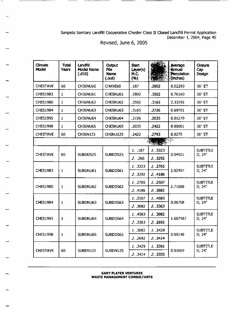
17.1 Models Incorporating the Five Wettest Years The following Table compares the results of 14 HELP3 model runs representing 60 years of average climate, followed by the five wettest years in descending order, and then another 60 years of average climate.
GARY PLAYER VENTURES WASTE MANAGEMENT CONSULTANTS
Sanpete Sanitary Landfill Cooperative Chester Class I I Qosed Landfill Permit Application December 1, 2004, Page 45
Revised, June 6, 2005
Qlmate Model
CHESTAVE
CHES1983
CHES1980
CHES1984
CHES1995
CHES1998
CHESTAVE
Total Years
60
60
Landfill Model Name (.dlO)
CH36NU60
CH36NU61
CH36NU62
CH36NU63
CH36NU64
CH36NU65
CH36N125
Output File Name
(.out)
CHAVE60
CHESNU61
CHESNU62
CHESNU63
CHESNU64
CHESNU65
CHSNU125
Start m e t i s ) M.C (%)
.187
.2802
.3502
.3165
.2726
.2035
.2422
•
.2802
.3502
.3165
.2726
.2035
.2422
.2793
i verage :#inual i^ercolation i^lnches)
0.02293
0.76160
2.33192
0.69701
0.01279
0.00001
0.0275
aosure Cap Deisign
36" ET
36" ET
36" ET
36" ET
36" ET
36" ET
36" ET
"^R^^" CHESTAVE
CHES1983
CHES1980
CHES1984
CHES1995
CHESI998
CHESTAVE
60
1
1
1
1
1
60
SUBDDS25
SUBDNU61
SUBDNU62
SUBDNU63
SUBDNU64
SUBDNU65
SUBDN125
SUBDDS25
SUBDDS61
SUBDDS62
SUBDDS63
SUBDDS64
SUBDDS65
SUBDN125
/. .187
Z .266
/. .3323
2. .3292
I. .2765
2. .4186
1. .2507
2. .3682
/. .4583
2. .3363
1. .3082
2. .2692
/. .3429
2. .3414
J. .3323
2. .3292
i . .2765
2. .4186
1. .2507
2. .3682
J. .4583
2. .3363
1. .3082
2. .2692
1. .3429
2. .3414
J. .3301
2. .3355
0.04501
2.02997
2.71888
0.06708
1.667987
0.00148
0.03669
SUBTTFLE D, 24"
SUBIIILE D, 24"
SUBTITLE D, 24"
SUBTTTLE D, 24"
SUBIIILE D, 24"
bUBIllLb D, 24"
SUBTITLE D, 24'
GARY PLAYER VENTURES WASTE MANAGEMENT CONSULTANTS
Sanpete Sanitary Landfill Cooperative Chester Class I I Closed Landfill Permit Application December 1, 2004, Page 46
Revised, June 6, 2005
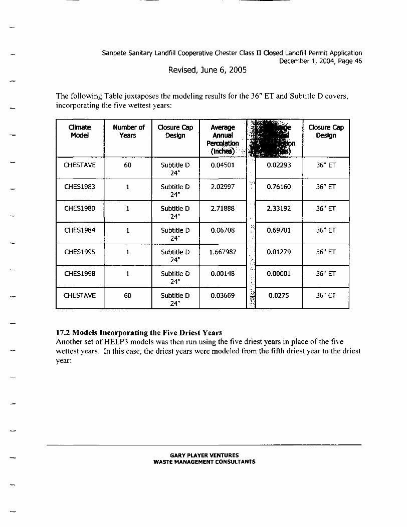
The following Table juxtaposes the modeling results for the 36" ET and Subtitle D covers, incorporating the five wettest years:
Oimate Model
CHESTAVE
CHES1983
CHES1980
CHES1984
CHES1995
CHES1998
CHESTAVE
Number of Years
60
60
Oosure Cap Design
Subtitle D 24"
Subtitle D 24"
Subtitle D 24"
Subtitle D 24"
Subtitle D 24"
Subtitle D 24"
Subtitle D 24"
Average Annual
Peroo^Alon (Iridlei) w^
0.04501
2.02997
2.71888
0.06708
1.667987
0.00148
0.03669 1
0.02293
0.76160
2.33192
0.69701
0.01279
0.00001
0.0275
Closure Cap Design
36" ET
36" ET
36" ET
36" ET
36" ET
36" ET
36" ET
17.2 Models Incorporating the Five Driest Years Another set of HELP3 models was then mn using the five driest years in place ofthe five wettest years. In this case, the driest years were modeled from the fifth driest year to the driest year:
GARY PLAYER VENTURES WASTE MANAGEMENT CONSULTANTS

Sanpete Sanitary Landfill Cooperative Chester Class II Closed Landfill Permit Application December 1, 2004, Page 47
Revised, June 6, 2005
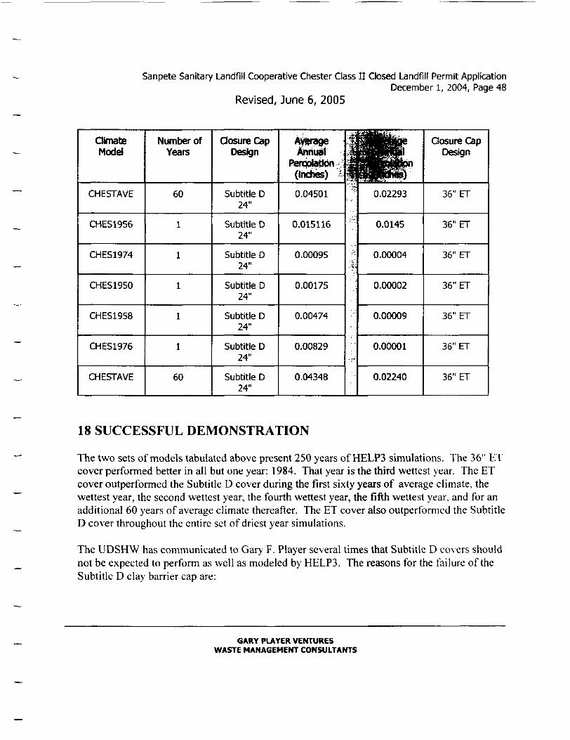
aimate Model
CHESTAVE
CHES1956
CHES1974
CHES1950
CHES1958
CHES1976
CHESTAVE
Years
60
60
landfill Model Name (.dlO)
CH36NU60
CDRY3661
CDRY3662
CDRY3663
CDRY3664
CDRy3665
CDRY125
Output File Name
(.out)
CHAVE60
CHDRY61
CHDRY62
CHDRY63
CHDRY64
CHDRY65
CHDRY125
Start Layer(s) M.C. (%)
.187
.2802
.2126
.2086
.2228
.2017
.1888
w .2802
.2126
.2086
.2228
.2017
.1888
.2800
Average Annual Percolation Onches)
0.02293
0.0145
0.00004
0.00002
0.00009
0.00001
0.02240
Closure Cap Design
36" ET
36" ET
36" ET
36" ET
36" ET
36" ET
36" ET
. • • - ^W l '
CHESTAVE
CHES1956
CHES1974
CHES1950
CHES1958
CHES1976
CHESTAVE
60
1
1
1
1
1
60
SUBDDS25
SUBDRY61
SUBDRY62
SUBDRY63
SUBDRY64
SUBDRY65
SBDRY125
SUBDDS25
SUBDRY61
SUBDRY62
SUBDRY63
SUBDRY64
SUBDRY65
SBDRY125
1. .187
2. .266
1. .3323
2. .3292
1. .3016
2. .2616
1. .3285
2. .2798
1. .2549
2 .3348
1. .2749
2 .2680
1. .2002
2 .2616
1. .3323
2 .3292
1. .3016
2 .2616
1. .3285
Z .2798
1. .2549
2 .3348
1. .2749
2 .2680
1. .2002
2 .2616
1, .3301
2 .3353
0.04501
0.015116
0.00095
0.00175
0.00474
0.00829
0.04348
SUBTITLE D, 24"
SUBTTTLE D, 24"
SUBTITLE D, 24"
SUBIIILE D, 24"
SUBIIILE D, 24"
SUBTITLE D, 24"
SUBTTTLE D, 24"
The following Table juxtaposes the modeling results for the 36" ET and Subtitle D co\ers. incorporating the five driest years:
GARY PLAYER VENTURES WASTE MANAGEMErrr CONSULTANTS
Sanpete Sanitary Landfill Cooperative Chester Class I I Closed Landfill Permit Application December 1, 2004, Page 48
Revised, June 6, 2005
Oimate Model
CHESTAVE
CHES1956
CHES1974
CHES1950
CHES1958
CHES1976
CHESTAVE
Number of Years
60
60
Oosure Cap Design
Subtitle D 24"
Subtitle D 24"
Subtitle D 24"
Subtitle D 24"
Subtitle D 24"
Subtitle D 24"
Subtitle D 24"
Annuvl PencblatJon •
(Indies) i
0.04501
0.015116
0.00095
0.00175
0.00474
0.00829
0.04348
fli y
y
r Hon
0.02293
0.0145
0.00004
0.00002
0.00009
0.00001
0.02240
Closure Cap Design
36" ET
36" ET
36" ET
36" ET
36" ET
36" ET
36" ET
18 SUCCESSFUL DEMONSTRATION
The two sets of models tabulated above present 250 years of HELP3 simulations. The 36" ET cover perfonned better in all but one year: 1984. That year is the third wettest year. The ET cover outperformed the Subtitle D cover during the first sixty years of average climate, the wettest year, the second wettest year, the fourth wettest year, the fifth wettest year, and for an additional 60 years of average climate thereafter. The ET cover also outperformed the Subtitle D cover throughout the entire set of driest year simulations.
The UDSHW has communicated to Gary F. Player several times that Subtitle D covers should not be expected to perform as well as modeled by HELP3. The reasons for the failure ofthe Subtitle D clay barrier cap are:
GARY PLAYER VENTURES WASTE MANAGEMENT CONSULTANTS

Sanpete Sanitary Landfill Cooperative Chester Class I I Closed Landfill Permit Application December 1, 2004, Page 49
Revised, June 6, 2005
(1) Cracking after drying (dessication cracks); (2) Enlargement of cracks due to Utah's active freeze-thaw cycle; and (3) Propagation of cracks due to landflll settlement.
The HELP3 model predicted that moisture contents in the lower, barrier clay layer would be reduced below the wilting point of default soil 25 (.266 vol./vol.) after the "driest" years 1956 and 1976. The predicted moisture content after 1956 was .2616 vol./voL, and the predicted moisture content after 1976 was also .2616 vol./vol. The moisture content for barrier soil in Subtitle D cover models in the years following 1956 and 1976 were manually set at .266 vol./voL, creating a conservative set of parameters for moisture content in the "driest years" set of models.
18.1 Comparison of Total Percolation Through Each Cap The total amount of moisture percolating through each cap during the 250 years modeled is summarized in the following Table:
Climate Model
CHESTAVE
CHES1983
CHES1980
CHES1984
CHES1995
CHES1998
CHESTAVE
Number of Years
60
60
Oosure Cap t)es[gn
Subtitle D 24"
Subtitie D 24"
Subtitle D 24"
Subtitle D 24"
Subtitle D 24"
Subtitle D 24"
Subtitle D 24"
. ^ ] 2.7006
2.02997
2.71888
0.06708
1.667987
0.00148
2.2014
l i
1.3758
0.76160
2.33192
0.69701
0.01279
0.00001
1.65
Oosure Cap Design
36" ET
36" ET
36" ET
36" ET
36" ET
36" ET
36" ET
GARY PLAYER VENTURES WASTE MANAGEMENT CONSULTANTS

Sanpete Sanitary Landfill Cooperative Chester Class II Closed Landfill Permit Application December 1, 2004, Page 50
Revised, June 6, 2005
125 YEARS TOTAL
(WETTEST) Subtitle D 24"
11.387397 6.82912 3 6 ' E T
Oin^te Model
CHESTAVE
CHES1956
CHES1974
CHES1950
CHES1958
CHES1976
CHESTAVE
125 YEARS TOTAL
250 YEARS TOTAL
Number of Years
60
60
(DRIEST)
(ALL MODELS)
Oosure Cap Design
Subtitle D 24"
Subtitie D 24"
Subtitle D 24"
Subtitle D 24"
Subtitle D 24"
Subtitle D 24"
Subtitle D 24"
Subtitle D 24"
Subtitle D 24"
f^L 2.7006
0.015116
0.00095
0.00175
0.00474
0.00829
2.6088
5.340246
16.727643
•.n
.tf.-
M
HI 1.3758
0.0145
0.00004
0.00002
0.00009
0.00001
1.344
2.73446
9.56358
Closure Cap Design
36" ET
36" ET
36" ET
36" ET
36" ET
36" ET
36" ET
36" ET
36" ET
18.2 Conclusions about Leachate Percolation The 36" ET cover cap has been shown to perform significanfly better than the Subtitle D 24" cap in 249 out of 250 years modeled.
The total amount of leachate predicted from the Subtitle D cap over the 125-year period including the wettest years is 1.67 times greater than the leachate predicted from the 36" ET cap during the same period. The total amount of leachate predicted from the Subtitle D cap over the 125-year period including the driest years is 1.95 times greater than the leachate
GARY PLAYER VENTURES WASTE MANAGEMENT CONSULTANTS

Sanpete Sanitary Landfill Cooperative Chester Class I I Closed Landfill Permit Application December 1, 2004, Page 51
Revised, June 6, 2005
predicted from the 36" ET cap during the same period. The total amount of leachate predicted from the Subtitle D cap over the entire 250 year period is 1.75 times greater than the leachate predicted from the 36" ET cap during the same period.
The HELP3 model does not take into account the likely cracking and consequent failure ofthe Subtitle D barrier clay layer.
PART VI-INFORMATION CONTAINED IN THE MARCH 22, 2004 LETTER
After a thorough review of site conditions and computer modeling predictions of leachate at Chester, the Sanpete Sanitary Landfill Cooperative and their consultants concluded that the proposed 36-inch thick cap of locally excavated fine-grained soils is a more stringent design than the standard design specified in Subsection R315-303-3(4)(a) to protect human health or the environment. We have also concluded that the proposed 36-inch thick cap meets the published regulatory requirements ofthe U.S. Environmental Protection Agency and the Utah Division ofSolid and Hazardous Waste.
19 COMPARISON OF PERCOLATION RATES FOR ET AND SUBTITLE D CLOSURE CAPS
Two sets of HELP3 models have been presented to UDSHW. The first set was included in the Sanpete Sanitary Landfill Cooperative Class II Landfill Closure Plan, April 16, 2003. The following Table 1 (repeated from April 16, 2003) shows that, given the same climatic conditions, the proposed 36-inch ET final closure cap performs twice as well as a prescribed Subtitle D clay cap. Both caps discharged some water after the two wettest years, but then were effective for the next 68 modeled years. Documentation for the data shown in this and the other Tables in this letter were presented to UDSHW in the respective reports.
GARY PLAYER VENTURES WASTE MANAGEMENT CONSULTANTS

Sanpete Sanitary Landfill Cooperative Chester Class I I Closed Landfill Permit Application December 1, 2004, Page 52
Revised, June 6, 2005
Year or Years
60 Years with Average Climate
1983 as Year 61 (Wettest)
1980 as Year 62
1984 as Year 63
1995 as Year 64
1998 as Year 65
1956 as Year 66
1974 as Year 67
1950 as Year 68
1958 as Year 69
1976 as Year 70 (Driest)
60 More Years with Average Climate, total of
130 years
Thirty-six Inch ET Covefv| Percolation (Inches/Yeai§"
.02512 (.638 mm/yr)
1.44952
4.04740
.00002
.000125
.00000
.00001
.00000
.00004
.00025
.00001
.02505
^ ^ b t i t l e D Clay Cap 3S©at lon (Inches/Year)
.05463 (1.39 mm/yr)
1.42499
5.66077
.00300
.08115
.00421
.00143
.01549
.21401
.66049
.00146
.05456
20 APPLICABLE REGULATIONS
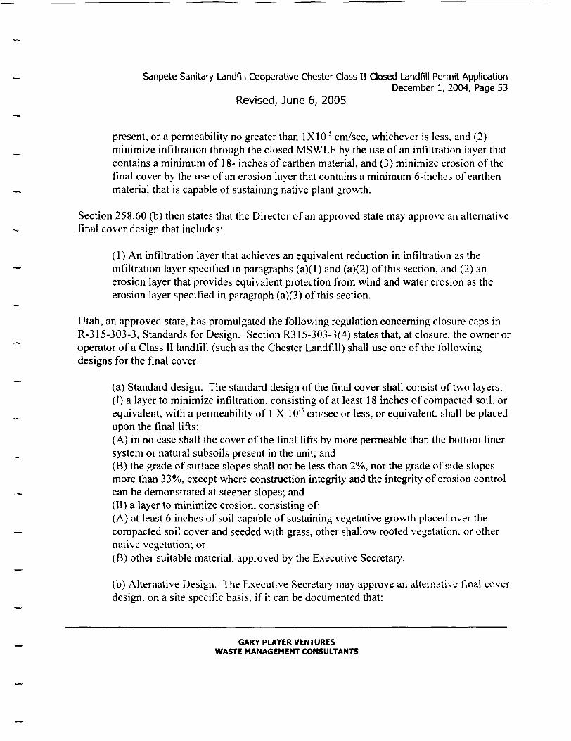
40 CFR Chapter 1 (7-1-96 Edition) lists acceptable closure criteria for municipal solid waste landfills. Section 258.60 (a) describes the so-called "standard" Subtitle D cover as follows:
The final cover system must be designed £ind constructed to: (I) have a permeability less than or equal to the permeability ofany bottom liner system or natural subsoils
GARY PLAYER VENTURES WASTE MANAGEMENT CONSULTANTS
Sanpete Sanitary Landflll Cooperative Chester Class I I Closed Landfill Permit Application December 1, 2004, Page 53
Revised, June 6, 2005
present, or a permeability no greater than 1X10"' cm/sec, whichever is less, and (2) minimize infiltration through the closed MSWLF by the use ofan infiltration layer that contains a minimum of 18- inches of earthen material, and (3) minimize erosion ofthe final cover by the use ofan erosion layer that contains a minimum 6-inches of earthen material that is capable of sustaining native plant growth.
Section 258.60 (b) then states that the Director ofan approved state may appro\'e an altemative final cover design that includes:
(1) An infiltration layer that achieves an equivalent reduction in infiltration as the infiltration layer specified in paragraphs (a)(1) and (a)(2) ofthis section, and (2) an erosion layer that provides equivalent protection from wind and water erosion as the erosion layer specified in paragraph (a)(3) ofthis section.
Utah, an approved state, has promulgated the following regulation conceming closure caps in R-315-303-3, Standards for Design. Section R315-303-3(4) states that, at closure, the owner or operator ofa Class II landfill (such as the Chester Landfill) shall use one ofthe following designs for the final cover:
(a) Standard design. The standard design ofthe final cover shall consist of two layers: (I) a layer to minimize infiltration, consisting of at least 18 inches of compacted soil, or equivalent, with a permeability of 1X10"' cm/sec or less, or equivalent, shall be placed upon the final lifts; (A) in no case shall the cover ofthe final lifts by more permeable than the bottom liner system or natural subsoils present in the unit; and (B) the grade of surface slopes shall not be less than 2%, nor the grade of side slopes more than 33%, except where construction integrity and the integrity of erosion control can be demonstrated at steeper slopes; and (II) a layer to minimize erosion, consisting of: (A) at least 6 inches of soil capable of sustaining vegetative growth placed over the compacted soil cover and seeded with grass, other shallow rooted vegetation, or other native vegetation; or (B) other suitable material, approved by the Executive Secretary.
(b) Altemative Design. The Executive Secretary' may approve an alternative final cover design, on a site specific basis, if it can be documented that:
GARY PLAYER VENTURES WASTE MANAGEMENT CONSULTANTS

Sanpete Sanitary Landfill Cooperative Chester Class I I Closed Landfill Permit Application December 1, 2004, Page 54
Revised, June 6, 2005
(I) the altemative final cover achieves an equivalent reduction in infiltration as specified as the standard design in Subsection R3I5-303-0(4)(a)(I); and (II) the altemative final cover provides equivalent protection from wind and water erosion as specified as the standard design in Subsection R315-303-3{4)(b)(ii)
The Solid Waste Permitting and Management Rules, dated October 15, 2003, include a third, more stringent, alternative closure cap altemative:
( c ) If a landfill has been constructed using an approved altemative landfill design, including a waiver, or exemption, from the liner or ground water moniloring requirements, the Executive Secretary may require, on a site specific basis, the landfill closure to be a more stringent design than the standard design specified in Subsection R315-303-3(4)(a) to protect human health or the environment.
Sanpete has provided a design for a more stringent closure cap than the Subtitle D cap specified in R315-303-3(4)(a). Computer modeling summarized above demonstrates that over a 130-year period the proposed 36-inch closure cap would allow infiltration ofa little less than half as much moisture as a standard design described in Subsection R315-303-3(4)(a).
Tables included in the July 31, 2003 Letter Report show infiltration through The Subtitle D standard design after 250 years would total 1.75 times more infiltration than would penetrate the proposed 36" thick evapotranspiration final cover cap in the same period. Therefore, the proposed landfill closure cap is a "more stringent design" than the standard design specified in Subsection R315-303-3(4)(a) to protect human health or the environment.
The last row from the comparison table in our July 31, 2003 letter is repeated below with columns rearranged and an additional row showing average annual infiltration:
Oimate Model
(ALL MODELS)
(ALL MODELS)
Number of Years
250 YEARS TOTAL
250 YEARS AVERAGE
Perool^^n ( Inch^ ) - : .
9.56358
.03825
. M 36" ET
36" ET
1 tl
'^HP^" Subtitle D
24"
Subtitle D 24"
Percolation (inches^
16.727643
.06691
GARY PLAYER VENTURES WASTE MANAGEMENT CONSULTANTS

Sanpete Sanitary Landfill Cooperative Chester Class I I Closed Landfill Permit Application December 1, 2004, Page 55
Revised, June 6, 2005
21 FINAL COVER DESIGN
21.1 Materials The infiltration layer for the final cover will be constructed of shallow soils obtained from the first ten feet of soils in a pit on the landfill property. The soils in the first 10 feet below ground level are clay loams, with a USCS class name of clay (CL), and a saturated hydraulic conductivity less than 3.26 X 10"' centimeters per second, when compacted to at least 90% of maximum dry density.
Copies of analyses ofthe soils from the surface to ten feet below ground level are presented in Appendices I and II.
21.2Thickness The evapotranspiration cover will be at least 36 inches thick. This thickness does not include intermediate cover soils that have already been placed over most ofthe landfill prism. The thickness ofthe cover may be increased to reflect measured quantities of gravel coarser than 2 millimeters.
21.3 Construction Procedures The ET cap will not be installed at "greater than optimum" moisture content (as is required for
a Subtitle D prescriptive cap), but with relatively dry soil at field conditions t> pical of Sanpete County. For that reason, the ET cover will be much less prone to damage from dessication or freeze-thaw cycles than a prescribed Subtitle D compacted clay cap.
A Landflll Closure Construction Plan will be submitted to UDSHW for approval by the Executive Secretary before constmcting the final cover. The Plan will illustrate how the final cover will be installed and will include constmction drawings and a Quality Assurance/Quality Control plan.
GARY PLAYER VENTURES WASTE MANAGEMENT CONSULTANTS
Sanpete Sanitary Landfill Cooperative Chester Class I I Closed Landfili Permit Application December 1, 2004, Page 56
Revised, June 6, 2005
Respectfully Submitted,
Gary F. Player Doug Bjerregaard Utah Professional Geologist No. 5280804-2250 Chairman, Sanpete Sanitar>'
Landfill Cooperative
C.ADocuments and Settings\Gar> F. Pla)cr\My Docunients\SANPETE LANDFILLS\CHESTER CL.ASS II CLOSURF.\REVlSED 060605 CHESTER CLOSURE PERMIT APPLlCATlON.wpd
GARY PLAYER VENTURES WASTE MANAGEMENT CONSULTANTS
Sanpete Sanitary Landfill Cooperative Chester Class I I Closed Landfill Permit Application (December 1, 2004, Page 57
Revised, June 6, 2005
FIGURES
Figure One: Map ofthe Class 11 Landfill.
Figures Two A and B: Final Cover Plan and Cross Sections.
Figure Three: Class IVb Landfill Map
Figure Four: Map showing Landfill slopes as measured with a hand level and compass, and the location of run-on control berms.
Figure Five: Map showing the drainage area, culverts through Highway 89 and the railroad grade, and breaches in the railroad grade south ofthe Landfill gate.
APPENDICES
Appendix 1: Copies of soil analyses prepared by Tri-State
Appendix II: Copies of soil analyses prepared by Geo Consultants.
ATTACHMENTS
Attachment 1: Proof of Ownership
Attachment 2: Annual Reporting Form
Attachment 3: Field Inspection Form
Attachment 4: A cost estimate for placing final cover and reseeding, obtained from Jensen Construction, Manti, Utah.
Attachment 5: A scanned copy of part ofthe most recent Chester, Utah, U.S. Geological Sur\'ey (USGS) topographic map ofthe site area.
GARY PLAYER VENTURES WASTE MANAGEMENT CONSULTANTS

Sanpete Sanitary Landfill Cooperative Chester Class I I Closed Landfill Permit Application December 1, 2004, Page 58
Revised, June 6, 2005
REFERENCES
Albright, W.H., and CH. Benson, 2002, "Altemative Cover Assessment Program 2002 Annual Report." Desert Research Institute Publication No. 41182. October, 2002.
Bolen, M.B., Roesler, A.C., Benson, C.H., and Albright. W.H., 2001, "Altemative Cover Assessment Program: Phase II Report." University of Wisconsin-Madison. Geo Engineering Report 01-10, September, 2001.
Dwyer, S.F., 2003, "Water Balance Measurements and Computer Simulations ofLandfill Covers." University of New Mexico, Civil Engineering Department, May 2003.
Dwyer, S.F., B. Reavis, and G. Newman , 2000, "Water Balance Data from the Altemative Landfill Cover Demonstration," Sandia National Laboratories Report, SAND 2000
National Oceanic and Atmospheric Administration, 1974, "Climatic Atlas ofthe United States."
Roesler, A.C., CH. Benson, and W.H. Albright, 2002, "Field Hydrology and Model Predictions for Final Covers in the Altemative Cover Assessment Program-2002." University of Wisconsin-Madison, Geo Engineering Report No. 02-08, September 20, 2002.
Ruffner, J. A., 1985, "Climates ofthe United States," 3" Edition, Gale Research Company. Detroit, Michigan, 758 pp.
GARY PLAYER VENTURES WASTE MANAGEMENT CONSULTANTS

y
Sanpete Sanitary Landfill Cooperative Chester Class I I Closed Landfill Permit Application December 1, 2004, Page 59
Revised, June 6, 2005
FIGURES
GARY PLAYER VENTURES WASTE MANAGEMENT CONSULTANTS
Sanpete Sanitary Landfill Cooperative Chester Class I I Closed Landfill Permit Application December 1, 2004, Page 60
Revised, June 6, 2005
ATTACHMENTS
GARY PLAYER VENTURES WASTE MANAGEMENT CONSULTANTS

Sanpete Sanitary Landfill Cooperative Chester Class I I Closed Landfill Permit Application December 1, 2004, Page 61
Revised, June 6, 2005
APPENDICES
GARY PLAYER VENTURES WASTE MANAGEMENT CONSULTANTS