Sanitary Survey Report for Shellfish Growing Area · PDF fileSanitary Survey Report for...
23
Sanitary Survey Report for Shellfish Growing Area A0Remote (Absecon Inlet to Beach Haven Terrace) December 2014 NJ Department of Environmental Protection Water Monitoring and Standards NJ Department of Environmental Protection Bob Martin, Commissioner State of New Jersey Chris Christie, Governor Kim Guadagno, Lt. Governor
-
Upload
dangkhuong -
Category
Documents
-
view
220 -
download
5
Transcript of Sanitary Survey Report for Shellfish Growing Area · PDF fileSanitary Survey Report for...

Sanitary Survey Report for Shellfish Growing Area A0Remote
(Absecon Inlet to Beach Haven Terrace)
December 2014
NJ Department of Environmental Protection
Water Monitoring and Standards
NJ Department of Environmental Protection
Bob Martin, Commissioner
Bob Martin, Commissioner
State of New Jersey
Chris Christie, Governor
Kim Guadagno, Lt. Governor
Kim Guadagno, Lt. Governor

Sanitary Survey Report for Shellfish Growing Area A0Remote
(Absecon Inlet to Beach Haven Terrace)
New Jersey Department of Environmental Protection
Water Resources Management
Daniel Kennedy, Assistant Commissioner
Water Monitoring and Standards
Patricia Gardner, Director
Bureau of Marine Water Monitoring
Bruce Friedman, Bureau Chief
December 2014
2000 - 2009
Report Prepared by:
Mike Curtis
Environmental Specialist 3
Acknowledgements:
This report was written under the direction of Patricia Gardner, Director and Bruce Friedman, Bureau Chief. Mike Kusmiesz
assisted in the collection and storage of statistical and GIS data used in analysis. Special acknowledgment is given to
Captain Hayek for perseverance in collecting shellfish water quality samples (for A0Remote – An Atlantic Ocean Shellfish
Growing Area) during the time frame discussed in this report. This study would not have been completed without the
analytical capabilities of our microbiology laboratory staff including Lisa DiElmo, Elena Heller, Carrie Lloyd, Bob
Seabrook, and Abolade Oyelade (advanced microbiology lab), along with our chemistry laboratory staff including Eric
Ernst, Dawn Thompson, and Bill Heddendorf (interim supervisor – microbiology and chemistry labs), with overall
supervision by Bob Schuster, Interim Section Chief.
Cover Photo – From the Forsythe National Wildlife Refuge – Brigantine Unit, Oceanville, NJ

i
TABLE OF CONTENTS
EXECUTIVE SUMMARY 1
GROWING AREA PROFILE 2 LOCATION AND DESCRIPTION 2
GROWING AREA CLASSIFICATION SUMMARY 3
EVALUATION OF BIOLOGICAL RESOURCES 4
SHORELINE SURVEY: EVALUATION OF POTENTIAL POLLUTION SOURCES 5 LAND USE 6
SURFACE WATER DISCHARGES – TREATMENT FACILITY WASTEWATER EFFLUENTS 7
SPILLS, UNPERMITTED DISCHARGES, AND CLOSURES 9
STORMWATER DISCHARGES 9
WATER QUALITIES STUDIES 11 SAMPLING STRATEGY 11
BACTERIOLOGICAL QUALITY 13
Compliance with NSSP APC Approved Criteria 13 Rainfall Effects 13
RELATED STUDIES 14
Nutrients 14 Phytoplankton Monitoring 15 Cooperative Coastal Monitoring 16
CONCLUSIONS 17
RECOMMENDATIONS 18
LITERATURE CITED 19
SUPPORTING DOCUMENTATION 20

1
EXECUTIVE SUMMARY
The water quality in the 15 Nautical Miles of Atlantic Ocean from Absecon Inlet in Atlantic
County to Beach Haven Terrace in Ocean County (Shellfish Growing Area A0Remote) is
consistent with its current Approved classification. As the waters of A0Remote (38,549 acres)
are classified in their entirety as Approved, the criteria used for shellfish growing water
classification review in this Sanitary Survey is based solely on Approved water classification (see
figure that follows). The State of New Jersey 2009 Shellfish Growing Water Classification
Charts (i.e., 10 – 12) also provide an excellent tool for viewing the location and classification for
A0Remote (see www.state.nj.us/dep/wms/bmw).
The data included in this report represents samples
collected between May 2000 and April 2009. Analysis
of the data indicates the waters of A0Remote met all
criteria for its current classification. It should be noted
that these ocean shellfish growing waters do not
contain any point sources of contamination although
A0Remote is flanked by point sources to the South
(Atlantic County Utilities Authority – Wastewater
Treatment Facility Discharge Pipe) and North (Ocean
County Utilities Authority – Southern Water Pollution
Control Facility Discharge Pipe). Further, A0Remote
is not detectably affected by non-point sources.
The lack of point and non-point sources in
combination with acceptable water quality support the
Approved shellfish growing water classification
currently in effect and qualifies this section of
coastline for its Remote Status designation. As such,
the National Shellfish Sanitation Program’s (NSSP) Guide for the Control of Molluscan Shellfish
suggests that a minimum of 2 samples shall be collected annually and an analysis of the most
recent 15 samples be undertaken to maintain an area with Remote Status designation.
A Remote Status area, by NSSP definition, allows for a water sampling frequency reduction
(minimum of two samples yearly as opposed to five) while removing concern for any public
health consequences due to the proven quality of the samples analyzed over time. This enables
valuable sampling resources to be concentrated in areas containing pollution sources. With
A0Remote, acceptable water quality prevails as noted within this report. At this time, there are
no changes recommended for the classification of this shellfish growing area.
2
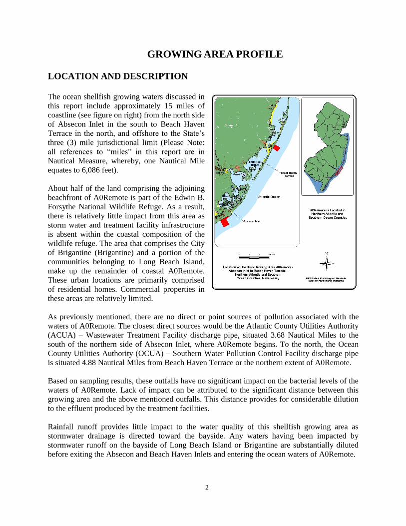
GROWING AREA PROFILE
LOCATION AND DESCRIPTION
The ocean shellfish growing waters discussed in
this report include approximately 15 miles of
coastline (see figure on right) from the north side
of Absecon Inlet in the south to Beach Haven
Terrace in the north, and offshore to the State’s
three (3) mile jurisdictional limit (Please Note:
all references to “miles” in this report are in
Nautical Measure, whereby, one Nautical Mile
equates to 6,086 feet).
About half of the land comprising the adjoining
beachfront of A0Remote is part of the Edwin B.
Forsythe National Wildlife Refuge. As a result,
there is relatively little impact from this area as
storm water and treatment facility infrastructure
is absent within the coastal composition of the
wildlife refuge. The area that comprises the City
of Brigantine (Brigantine) and a portion of the
communities belonging to Long Beach Island,
make up the remainder of coastal A0Remote.
These urban locations are primarily comprised
of residential homes. Commercial properties in
these areas are relatively limited.
As previously mentioned, there are no direct or point sources of pollution associated with the
waters of A0Remote. The closest direct sources would be the Atlantic County Utilities Authority
(ACUA) – Wastewater Treatment Facility discharge pipe, situated 3.68 Nautical Miles to the
south of the northern side of Absecon Inlet, where A0Remote begins. To the north, the Ocean
County Utilities Authority (OCUA) – Southern Water Pollution Control Facility discharge pipe
is situated 4.88 Nautical Miles from Beach Haven Terrace or the northern extent of A0Remote.
Based on sampling results, these outfalls have no significant impact on the bacterial levels of the
waters of A0Remote. Lack of impact can be attributed to the significant distance between this
growing area and the above mentioned outfalls. This distance provides for considerable dilution
to the effluent produced by the treatment facilities.
Rainfall runoff provides little impact to the water quality of this shellfish growing area as
stormwater drainage is directed toward the bayside. Any waters having been impacted by
stormwater runoff on the bayside of Long Beach Island or Brigantine are substantially diluted
before exiting the Absecon and Beach Haven Inlets and entering the ocean waters of A0Remote.

3
GROWING AREA CLASSIFICATION SUMMARY
In a 1994 report for A0Remote covering the time frame 1991 to 1993, it was recommended this
shellfish growing area be designated as having Remote Status. Remote Status, as suggested in
NSSP’s shellfish guide, is applicable for shellfish growing waters which are not impacted by any
actual or potential pollution sources, and those waters meet Approved classification criteria. The
stations within A0Remote have had a continuous record of satisfying NSSP criteria for Remote
Status both then and now.
The last report written for Shellfish Growing Area A0Remote was a 2007 Reappraisal (rewritten
Dec. 2014) covering the years 1998 – 2006. The shellfish growing waters under analysis as
A0Remote met the NSSP's criteria for Approved in that report, as well.
All such reviews have determined that there are no direct source inputs to the waters of this
shellfish growing area. And, water quality represented by monitoring data suggests stormwater
runoff, which is generally directed to the bayside in this area, appears to receive substantial
dilution before reaching the ocean shellfish growing waters of A0Remote.
In the 2007 Reappraisal for A0Remote, it was decided that the area's Approved shellfish growing
water classification would remain in effect and that this growing area’s Remote Status
designation should be continued. The information contained within this Sanitary Survey for the
years, 2000 – 2009 will contend the same, as there are no changes recommended for A0Remote.
The shellfish growing water classifications by percentage and acreage are shown in the figures
below.

4
EVALUATION OF BIOLOGICAL RESOURCES
Historically, Approved ocean waters have been used for harvesting surf clams (Spisula
solidissima) and blue mussels (Mytilus edulis) by dredge boats licensed by the Division of Fish
and Wildlife. Surf clams (for bait purposes only – non-human consumption) can also be
harvested from Prohibited areas under a special program administered by WM&S/BMWM and
enforced by the Division of Fish and Wildlife.
In addition to being the State’s largest molluscan fishery (i.e., regarding lbs. landed), New
Jersey’s surf clam fishery historically leads all other surf clamming states in total annual
landings, and continues to do so according to the most recently released statistics from NOAA’s
National Marine Fisheries Service. The table below denotes commercial landings in pounds of
meat and ex-vessel value for New Jersey surf clams from 1993 through 2009.
Commercial Data for Surf Clams Showing Pounds of Meat and Ex-vessel Value for New Jersey Landings
(1993 - 2009). Source: NOAA - National Marine Fisheries Service
YYeeaarr Lbs. of Surf Clams Landed Ex-vessel Value
1993 47,978,097 $ 21,802,735
1994 48,572,236 $ 26,840,477
1995 46,329,437 $ 27,443,281
1996 48,740,881 $ 28,983,170
1997 45,603,401 $ 27,168,453
1998 44,751,327 $ 23,060,750
1999 49,299,900 $ 25,371,922
2000 58,047,629 $ 31,371,354
2001 52,872,341 $ 29,326,676
2002 53,590,740 $ 29,172,373
2003 51,336,955 $ 27,431,645
2004 43,521,704 $ 22,284,335
2005 38,967,993 $ 20,028,662
2006 43,643,726 $ 25,106,785
2007 44,791,212 $ 26,546,602
2008 39,346,425 $ 24,349,551
2009 32,893,521 $ 20,568,576
Since New Jersey’s surf clam industry is at the national forefront in total landings, monitoring,
management, and conservation of this resource is very important to the State. In this regard, the
New Jersey Surf Clam Advisory Committee, comprised of industry and government
representatives, in conjunction with the Commissioner for the New Jersey Department of

5
Environmental Protection, sets the quotas for harvest. A brief history of those quotas and the
ocean bi-valves with the largest landings for the State are shown in the tables that follow.
New Jersey Surf Clam Quotas in Industry Bushels by Year (1996 – 2009). Source: New Jersey Department of
Environmental Protection, Bureau of Shellfisheries
Surf Clam Harvest Year Surf Clam Quotas in Industry Bushels
1996 - 1997 600,000
1997 - 1998 600,000
1998 - 1999 700,000
1999 - 2000 700,000
2000 - 2001 700,000
2001 - 2002 600,000
2002 - 2003 600,000
2003 - 2004 275,000
2004 - 2005 350,000
2005 - 2006 237,000
2006 - 2007 240,000
2007 - 2008 198,000
2008 - 2009 58,368
Ocean Bi-Valves w/ Largest Landings Reported for New Jersey (0 - 3 Miles Distance from Shore highlighted in yellow)
DISTANCE FROM N. J. SHORE
0 - 3 MILES 3 - 200 MILES HIGH SEAS COMBINED TOTALS
COMMON BI-VALVE
NAME
Pounds of
Meat
(000)
Dollars
(000)
Pounds of
Meat
(000)
Dollars
(000)
Pounds of
Meat
(000)
Dollars
(000)
Total Pounds of
Meat
(000)
Total
Dollars
(000)
Price/
Pound of
Meat
Surf Clam 7,959 4,641 17,130 11,370 - - 25,089 16,011 $.64
Sea Scallops 56 497 14,098 108,492 - - 14,155 108,990 $7.70
Ocean Quahog 2,141 1,104 11,307 6,775 - - 13,448 7,878 $.59
-- TOTALS -- 10,156 6,242 42,535 126,637 - - 52,692 132,879
Adapted from: Landings by Distance from U.S. Shores, 2010, State of New Jersey, National Marine Fisheries Service - Fisheries Statistics and Economics
Division - Report printed on: 02/27/13
* No Data Available
SHORELINE SURVEY: EVALUATION OF POTENTIAL
POLLUTION SOURCES
Shoreline surveys or site specific tours of areas nearby or abutting shellfish growing waters can
provide insight as to the location and nature of land use, surface water discharges, marinas,
unpermitted discharges, and stormwater inputs. Shoreline surveys for A0Remote were conducted

6
on July 09, 2010 and November 19, 2010. The following sections detail information derived
collectively from those surveys, and any that preceded them.
LAND USE
Areas for new development are generally limited within the municipalities or boroughs abutting
A0Remote as much of the land that could be used for such projects has already been developed.
Under normal circumstances, some new construction projects do take place in areas where
homes are torn down and new homes are constructed. And, there are some new home projects
taking place on previously vacant land. In addition, many of the homes and businesses within
coastal A0Remote do undergo reconstruction and refurbishment from time to time.
Impact from construction is unlikely though due to the nature of the land and water abutting and
surrounding this shellfish growing area. Construction projects bordering on eco-sensitive areas
such as those in A0Remote are required by local, state, and federal regulations to utilize specific
setbacks and buffers as a means of protecting flora and fauna specific to wetland, riparian, or
estuarine locations. The use of these buffers can never be understated as their utilization suggests
construction is unlikely to severely impact surrounding natural ecosystems.
Aside from contributing to productivity, wetland and estuarine zones provide valuable habitat for
many marine species during some point of their life cycle. In addition, some plant species within
these zones take up contaminants from the ecosystem.
Large areas of wetlands and coastal vegetation can be found in close proximity to urban
development in A0Remote. The largest of these areas are located in the Brigantine and Holgate
units of the Edwin B. Forsythe National Wildlife Refuge (i.e., northern Brigantine and southern
Long Beach Island), as shown in the above maps.

7
The lands adjacent to Shellfish Growing Area A0Remote can geophysically be described as
barrier islands. The predominant land use on these barrier islands is urban.
There are a number of mainland
communities situated just to the
west of A0Remote, as shown in the
figure to the right. Presently,
WM&S/BMWM water quality
testing shows that these
communities have minimal impact
on the waters of this growing area
with regard to their septic/sewerage
infrastructure and current
population.
Although homes along coastal
A0Remote utilize the wastewater
treatment facilities associated with
ACUA and OCUA’s southern plant,
there are pockets of homes that
utilize septic systems within the
nearby Pinelands. Septic is
primarily utilized in areas of lower
population density. Generally, the
availability for access to city sewage
infrastructure is less likely in these
areas. There are always concerns
regarding nutrient loading and
elevated coliform levels within
watersheds near communities
utilizing septic. However, the
distance from these communities to
this growing area provides a safety
zone for dilution.
SURFACE WATER DISCHARGES – TREATMENT FACILITY
WASTEWATER EFFLUENTS
Evaluation and compliance of shellfish growing areas is ascertained using NSSP criteria as
contained in the Guide for the Control of Molluscan Shellfish, 2013. Interaction between the
State and treatment plants is important in determining plant efficiency, which integrally relates to
the eventual effluent quality discharged into ocean waters off the coast of New Jersey. State
effluent standards for direct discharge, and treatment facility wastewater effluent discharge
locations near A0Remote are shown in the table and figure on the next page.

8
Effluent Standards for Direct Discharge to Surface Water from Publicly/Privately Owned Wastewater
Treatment Facilities – NJPDES Permit Regulations (7:14A – 12.2 – 12.5)
Avg. BOD5 Level/Wk. ≤ 45 mg/L
Avg. BOD5 Level/Mo. ≤ 30 mg/L
Avg. BOD5 % Removal/ Mo. ≥ 85%
or Avg. CBOD5 Level/Wk. ≤ 40 mg/L
or Avg. CBOD5 Level/Mo. ≤ 25 mg/L
or Avg. CBOD5 % Removal/ Mo. ≥ 85%
Avg. TSS Level/Wk. ≤ 45 mg/L
Avg. TSS Level/Mo. ≤ 30 mg/L
Avg. TSS % Removal/ Mo. ≥ 85%
Geo. Mean FC/Wk. ≤ 400 MPN/100 mL
Geo. Mean FC/Mo. ≤ 200 MPN/100 mL
Sewage from communities adjacent or
near A0Remote is carried to
wastewater treatment facilities by
sanitary sewers. In the case of
Brigantine, sewage is treated by the
Atlantic County Utilities Authority –
Wastewater Treatment Facility (ACUA
– WTF) for eventual ocean discharge
off Ventnor (south of Brigantine and
A0Remote).
Beach Haven Terrace and communities
south through Holgate on Long Beach
Island, utilize the Ocean County
Utilities Authority – Southern Water
Pollution Control Facility (OCUA-
SWPCF). Effluent from OCUA’s
southern facility is ultimately disposed
of off Ship Bottom (north of Beach
Haven Terrace and A0Remote).
No effluent is discharged into the shellfish growing waters of A0Remote. The effluent discharge
lines and outfalls for the above mentioned treatment facilities are located 3.68 to 4.88 nautical
miles outside the borders of A0Remote.
Recent site visitations and current information for the above treatment facilities suggests that
they are able to and can operate efficiently with regard to design, current population demands,
and emergency events (e.g., storm situations – plant/operator failure). More specific evaluations
for these plants can be found in reports for A0South and A0Cent, as the ACUA and OCUA
treatment facilities can respectively be found in those shellfish growing areas. A0South and
A0Cent reports can be found at www.state.nj.us/dep/wms/bmw.

9
SPILLS, UNPERMITTED DISCHARGES, AND CLOSURES
The map to the right shows the location of spills or
unpermitted discharges that occurred in areas that have
relative proximity to the A0Remote coastal boundary.
These occurrences were reported within the time frame that
this report was written. These spills or unpermitted
discharges did not result in the closure of waters in
shellfish growing area A0Remote.
Leaks or spills that do take place within New Jersey’s
shellfish growing waters are often the result of a variety of
circumstances such as boats sinking; issues with sewage
treatment plants such as pump station failure, broken sewer
lines, sewer line back up, manhole overflow, broken pipes
in commercial or residential locations, improper run off
from commercial or residential locations, construction, and
road runoff.
Often, the spills or unpermitted discharges noted above have limited impact on the chemical or
bacteriological water quality in a shellfish growing area like A0Remote. Generally, the spills and
discharges are rather small, and their distance to these shellfish growing waters is such that
impact is reduced from dilution, percolation, and absorption. From the perspective of this report,
which is generally founded on bacteriological results for fecal coliform, WM&S/BMWM station
data for A0Remote continue to show good water quality. Again, no specific spill or discharge
brought about the closure of shellfish growing waters for A0Remote during this reporting period.
STORMWATER DISCHARGES
Environmental pressures on shellfish beds in New Jersey
can originate in materials that enter growing waters via
stormwater. These materials include bacteria, as well as
other waste that enters the stormwater collection system.
Management of stormwater runoff along this section of
coastline (adjacent to A0Remote) consists of directing
flow into rivers and back bays (away from the ocean), as
shown in the map to the right.
As suggested in the section on Land Use, shoreline
surveys were conducted for A0Remote during July 2010
and November 2010. The field work conducted during
those surveys continued to be supportive of past surveys,
in that it validated statements in previous reports
suggesting stormwater runoff is extremely limited in its
potential to impact A0Remote due to dilution,
percolation, and absorption.

10
For the town of Brigantine, the topography is fairly flat. As a result, a limited amount of
stormwater infrastructure is designed to direct stormwater towards drainage systems which
empty into the base of sand dunes at the top of ocean block streets, where percolation and
filtration take place. In these instances, there can be up to 200 feet of dune expanse (width) and
another 300-foot width of beach for stormwater to travel before possibly reaching the ocean.
Stormwater runoff in these areas is absorbed through substantial layers of vegetation and sand.
In other cases, Brigantine uses catch basins located near the dune line to capture storm water
inputs for disposal, percolation, and in many cases, redirection away from the ocean. Catch
basins are more commonly utilized as replacement infrastructure today.
Where topography allows for drainage to the back bay for dilution of stormwater inputs, the
town of Brigantine frequently attempts to capture stormwater debris and floatables prior to their
entering the bay. This is done with the help of a rubber boot that is placed over some outfall
openings.
Rubber boots are helpful in retaining stormwater debris providing a town routinely cleans and
maintains the capture basins. Shoreline surveys suggest the town of Brigantine does do a good
job keeping up on debris removal from such retention areas.
In the northern sector of this growing area, we find that Long Beach Island’s topography slopes
away from the ocean. As such, stormwater runoff is primarily directed and discharged toward the
bay. Although surface runoff from Long Beach Island eventually enters the ocean shellfish
growing waters of A0Remote through Beach Haven Inlet, any input of this type should be
substantially diluted upon arrival.
A large portion of the water flowing into the southerly sector of this growing area from Beach
Haven Inlet and, to a lesser degree, from Absecon Inlet, comes from estuarine areas classified in
large part as Approved shellfish growing waters. Those estuarine areas include Little Egg
Harbor, Great and Little Bays, along with large portions of Reeds and Absecon Bays. These
embayment’s do receive many of the stormwater inputs that might otherwise be directed into the
ocean waters of A0Remote. These inputs are substantially diluted within these systems when
considering the total area or acreage these bays comprise. As these embayment’s eventually feed
into the ocean shellfish growing waters of A0Remote, it is important to understand that their
water quality in terms of bacteriological monitoring and related data is generally good, despite
stormwater inputs they receive. This lends support to the suggestion that impacts from
stormwater inputs are fairly limited for this shellfish growing area.
As previously mentioned, major portions of the shoreline bordering the central to south central
sections of A0Remote are comprised of the Holgate Unit (more than 400 acres) and Brigantine
Unit (approx. 1415 acres) of the Edwin B. Forsythe National Wildlife Refuge. These refuge
areas contain vast indigenous and migratory bird populations as shown by shoreline surveys.
Together, the sectors of refuge adjoining A0Remote represent a portion of more than 46,000
acres of national coastal preserve and habitat, specifically set-aside for birds and other wildlife.
Inputs from wildlife and avian populations can contribute higher levels of FC to the water

11
column from direct input or indirect runoff. In the case of A0Remote, bacteriological levels
suggest there is no impact derived from these populations. Distance between A0Remote waters
and wildlife populated areas of the refuge appears substantial enough to reduce or limit coliform
inputs to these shellfish growing waters by dilution processes.
WATER QUALITIES STUDIES
SAMPLING STRATEGY
Shellfish growing area A0Remote was sampled using the Remote Status Sampling Strategy. As
summarized in the Executive Summary, remote status consists of a sampling strategy requiring a
minimum 15 sample composite of data [similar to the Adverse Pollution Condition (APC)
Sampling Strategy], collectively supported by a minimum requirement of two samples per year.
Each shellfish producing state is directed to adopt either the total coliform or fecal coliform
criterion to classify its waters. The criteria were developed to ensure that shellfish harvested from
designated waters would be free of pathogenic (disease-producing) bacteria. Combinations of
coliform analysis criterion may also be used.
This report was written in 2010, and at that time, FC analysis was accomplished using direct 3
tube, A-1. While New Jersey had been using fecal coliform analysis (direct 3 tube, A-1) and
criteria for its ocean waters and total coliform analysis (3 tube, three dilution) and criteria for its
back bay areas, BMWM/WM&S switched all State shellfish growing areas over to the criteria for
fecal coliform in February, 2012, and the method for analysis changed as well.
BMWM/WM&S now use mTEC agar plating to facilitate the fecal coliform bacteriological
analysis for samples taken within New Jersey shellfish growing areas, and had been acquiring
adjunct mTEC data for its growing areas for some time in order to statistically facilitate the
transition to mTEC. Statistical facilitation, in the case of Shellfish Growing Area A0Remote refers
to the combination of past, 3 tube, A-1 data with current mTEC data in order to obtain statistically
valid measurements during the transition.
Each classification criterion is composed of a measure of the statistical “central tendency”
(geometric mean) and the relative variability of the data set. For the Adverse Pollution Condition
sampling strategy, variability is expressed utilizing the 90th percentile, and this statistical analysis is
also expressed or utilized when analytically reviewing stations located in areas of Remote Status.
Although the State has only Approved and Prohibited classifications in its ocean waters, an area to
be Approved under the Seasonal classification using APC would have to be sampled and meet the
criterion during the time of year that it is Approved for the harvest of shellfish. The table that
follows shows the statistical criteria for the APC strategy. The area on the chart highlighted in
yellow represents the criteria used when analyzing with direct 3 tube, A-1, which was utilized in
the preparation of this report.

12
Statistical Criteria for Adverse Pollution Condition/Remote Status Sampling Strategy
Total Coliform Criteria Fecal Coliform Criteria
Geometric mean
(MPN/100 mL)
No more than 10% of
samples can exceed
(MPN/100 mL)
Geometric mean
(MPN/100 mL)
No more than 10% of
samples can exceed
(MPN/100 mL)
Approved Water
Classification
70 330 14 49 w/ direct 3-tube, A1
31 w/ mTEC Agar
Special Restricted
Water Classification
700 3300 88 300 w/direct 3-tube,
A1
163 w/ mTEC Agar
Data management and analysis was accomplished using database applications developed for the
Bureau. Mapping of pollution data was performed with the Geographic Information System (GIS:
ARCMAP).
Water sampling was
performed in accordance with
the Field Sampling
Procedures Manual (NJDEP,
2005). Water quality
sampling, analysis, and
shoreline/watershed surveys
were conducted in accordance
with the NSSP Guide for the
Control of Molluscan
Shellfish, 2013.
The results were compiled
from the 16 surface stations
that comprise Assignment
471. A review of the records
suggests 240 water samples
were collected for fecal
coliform bacterial analysis
between 2000 and 2009 and
analyzed using direct 3 tube,
A-1 analysis. Additional
information on lab
methodology and sampling
strategy can be found in the
Shellfish Growing Area
Report Guidance Document.

13
The shellfish growing water monitoring stations from Absecon Inlet to Beach Haven Terrace
(A0Remote) are presented in the figure on the previous page. Classification determinations were
made by WM&S/BMWM at Leeds Point based on the data gathered from monitoring and analysis.
BACTERIOLOGICAL QUALITY
Compliance with NSSP APC Approved Criteria
For this Sanitary Survey, final analyses in conjunction with NSSP requirements for Approved
waters suggests this shellfish growing area is appropriately classified, as Approved in its entirety.
No stations had geometric means or 90th percentile scores that exceeded requirements for
Approved shellfish growing waters using fecal coliform direct 3 tube A-1 analysis.
The raw data provided just one instance of elevated fecal coliform levels (one of 240 samples
with an MPN of 43/100 mL on 6/05/03 - station A69A2). As this occurrence was rare, it
registered no impact for statistical summaries on final evaluation.
The appropriate data analysis for this shellfish growing area (geometric mean shall not exceed 14
MPN/100 mL and not more than 10% of the samples should exceed 49 MPN/100 mL) produced
no stations exceeding statistical criteria on summary evaluation for Approved waters. The data
presented in this report show most stations had geometric means of 2.6 MPN/100 mL and none
were higher than 3.2 MPN/100 mL. And, all monitoring stations for A0Remote showed 0 %
greater than 49 for the 90th percentile in the raw data with 15 or more samples.
With this, the bacteriological water quality for this growing area is conducive for harvesting
shellfish that are safe for human consumption. All data sets support the currently classified
Approved waters for A0Remote.
Rainfall Effects
Precipitation patterns in the coastal areas of New
Jersey are typical of the Mid-Atlantic coastal region.
Summer storms are localized and often associated
with thunder and lightning activity. Winter storms
are frequently associated with northeasters.
Hurricanes can occur during the summer and early
fall. Additional information on annual storm
averages, duration, intensity, and event volume is
provided in the Shellfish Growing Area Report
Guidance Document.
Precipitation data for A0Remote was provided by the
National Oceanic and Atmospheric Administration
(NOAA) with WM&S’/BMWM’s use of station
RA023 (see map to the right) for the shellfish
growing area.

14
The bacteriological water quality analysis for precipitation in this shellfish growing area report
revealed no impact or effect from rainfall for this reporting period. As a result, no change in
sampling strategies or shellfish classifications, related to precipitation are required at this time. In
addition, large storms, or severe winter, cyclonic events (“nor’easters”), have not been all that
significant during this review period, and impact from hurricanes was limited during that same
time frame.
RELATED STUDIES
Nutrients
WM&S/BMWM perform additional water quality studies related to the bacteriological
monitoring program. Nutrient monitoring and the collection of nutrient data is an example of one
of those studies, and is part of WM&S’/BMWM’s Ambient Marine Water Monitoring Program.
Stations for the Ambient Marine Water Monitoring Program are derived from an area weighted
probabilistic sampling design. This provides a broader assessment, based on acreage of estuarine
waters. Ocean waters are also sampled although in lessor frequency than State back bay waters.
Currently, there are 40 + nutrient sampling stations within the estuarine waters of New Jersey. At
the time this shellfish growing area report was written, ocean nutrient sampling for this growing
area involved seven stations, as shown in the map below.
Chlorophyll data are also contained within the nutrient
data. As such, WM&S’/BMWM is able to maintain an
ongoing picture of algal activity within State waters. This
chlorophyll data also proves to be useful as adjunct
information to the Bureau’s phytoplankton monitoring
program.
Increased chlorophyll levels are also identified by
WM&S/BMWM with the aid of a remote chlorophyll
flight sensor. WM&S’/BMWM’s remote aircraft sensing
began in 2007, and involves partnerships with New
Jersey’s Forest Fire Service (plane services), Rutgers
(data storage); USEPA Region 2 (funding). With this
program, flights take place six days a week, weather
permitting, during spring and summer. These flights
provide estimates of State coastal chlorophyll levels and a
perspective on bloom conditions/trends.
If chlorophyll sensing suggests an area of the State is experiencing a bloom, WM&S/BMWM
target sample from shore or by boat. Subsequently, such samples are analyzed at the Leeds Point
Lab so species type and concentration levels are known.

15
Further information on nutrients within State waters is available at
www.state.nj.us/dep/wms/bmw in report sections such as those referring to Estuarine and Coastal
Water Quality. Ambient results and nutrient data additionally serve other reports such as the
States’ Integrated Assessment Report.
Phytoplankton Monitoring
The WM&S/BMWM phytoplankton monitoring program involves the collection of water
column samples in order to evaluate and determine the presence of marine biotoxins associated
with certain algal species, as NSSP requires shellfish harvesting states to have a Biotoxin
Contingency Plan. Were there to be a toxic algal bloom for some duration, shellfish tissue
samples would also be analyzed, and if found to contain toxins, the State would be required to
close impacted shellfish growing waters.
Although New Jerseys
marine waters are
generally not
associated with toxic
algal species or
blooms of this type,
the Biotoxin
Contingency Plan is
required for public
health and safety, as
ingestion of shellfish
that have fed on toxic
algal species, can
cause an array of
human health issues.
Currently, the
WM&S/BMWM
Phytoplankton
monitoring program
consists of 48 marine
water stations (see
figure on right),
located in both
estuarine and front
ocean waters. The data
and information
gathered in this
sampling is used as
adjunct information, if
necessary (bloom and
species dependent), in

16
State Annual, Reappraisal, and Sanitary Survey reports for shellfish growing areas. Additionally,
reports denoted as Summary of Phytoplankton Blooms have been compiled and are available
electronically at www.state.nj.us/dep/wms/bmw.
Currently station AX61A1 has been allocated as the phytoplankton station within the A0Remote
shellfish growing area. Limited results exist for this station thus far but a review of
WM&S’/BMWM’s Annual Summary of Phytoplankton Blooms and Related Conditions in New
Jersey Coastal Waters suggests populations of phytoplankton are generally sparse to the north and
south of this station, where phytoplankton stations have been located for some time. And, toxic
species blooms of any duration have not been associated with the areas where those stations are
located (again see www.state.nj.us/dep/wms/bmw).
There are occasional occurrences of algal blooms in all ocean waters in New Jersey, and these
can occur throughout the year. The warmer months of spring and summer provide a very
common period for algal growth, though.
It is more frequently the discoloration of the water from algal blooms that causes issues along
New Jersey’s coastal waters rather than the toxicity of the phytoplankton. For example, brown
tides resulting from one of New Jersey’s more frequent algal blooms can be spotted in back bay
waters, inlets, and occasionally the ocean, near inlet passageways. This generally occurs during
May and June. However, aside from the bloom causing discoloration of the water, there are no
known threats to human health from brown tides. For this reason, they are not considered in
classifying waters for shellfish harvest.
Cooperative Coastal Monitoring
WM&S/BMWM also oversee the Cooperative Coastal Monitoring Program (CCMP). CCMP
involves coastal water quality assessments and pollutant source investigation. There are two
components to this program. These are recreational water quality monitoring at New Jersey
bathing beaches and aerial surveillance of State coastal waters.
Water quality monitoring for the bathing beach component is administered by NJDEP, the
Department of Health and local environmental health agencies interacting within their regions of
coastal New Jersey. These agencies collect water samples each week at 180 ocean and 35 bay
monitoring stations from mid-May through mid-September. Samples are taken on Monday and
continued sampling through the week is performed as required. Samples are analyzed for
enterococci bacteria concentrations at these monitored stations.
Enterococci are used as a fecal coliform indicator in marine recreational waters (US EPA, 1986).
The acceptable rate for the “steady state geometric mean indicator density” for enterococci in the
waters of marine bathing beaches is 35 MPN/100 mL or less, and 104 enterococci/100 mL is also
considered acceptable as a one time exposure (Cabelli, 1983).

17
At the time this report was written, A0Remote had
14 bathing beach stations as shown in the map to
the right. Data for these stations is available at
http://www.njbeaches.org.
The other component of the CCMP program, aerial
surveillance, is conducted six days a week, weather
permitting. Having this component provides an
evaluative tool to aerially observe coastal water
quality and potential pollution sources.
Flight paths are coordinated to observe the eastern
coastal and inter-coastal waters of the State during
the week. The aerial component of the CCMP
program works in conjunction with the United
States Army Corps of Engineers. It is part of the
NY/NJ Harbor Estuary Program Floatables Action
Plan. If floating solid waste and debris are spotted
by aerial surveillance, the Army Corps attempts to
respond with water-skimming vessels.
CONCLUSIONS
The following was concluded based on the water quality data from July 12, 2000 through March
05, 2009. The shellfish growing waters within this 15-mile stretch, known as A0Remote,
continue to meet NSSP criteria for classification as Approved in their entirety.
Remote Status had been previously designated for these waters due to the lack of direct and
indirect pollutant sources, and good water quality. This status shall remain unchanged with
regard to the data presented in this report. In addition, rain and seasonal effects were absent for
this Sanitary Survey with regard to the data.
The effluents from outfalls of the Atlantic County Utilities Authority – Wastewater Treatment
Facility Discharge Pipe (South of A0Remote) and the Ocean County Utilities Authority –
Southern Water Pollution Control Facility Discharge Pipe (North of A0Remote) are not
impacting the shellfish growing waters of this area with significant coliform levels.
There were no indications that indirect discharges such as spills impacted the Approved waters of
this growing area. The general absence of indirect discharges and stormwater outfalls along the
coastal shoreline of A0Remote greatly reduces concern for impact to the Approved waters of this
growing area. In addition, stormwater discharge into back bay waters appears to be significantly
diluted prior to reaching the ocean waters of A0Remote.
As in the case of indirect sources associated with A0Remote, substantial dilution seems to occur
to coliform input by avian or wildlife populations utilizing the closely situated Edwin B.
Forsythe National Wildlife Refuge.

18
Coliform levels are far too low in the data that supports this report to suggest there is substantial
impact from any of the potential sources mentioned in this section and throughout this Sanitary
Survey. The monitoring data derived from WM&S/BMWM analysis, supports a characterization
of good water quality for A0Remote.
RECOMMENDATIONS
With regard to the summarizations presented in this report, there are no changes proposed for
A0Remote, Assignment 471 monitoring stations, or sampling strategy (APC/Remote Status)
planned at this time. The area's Approved shellfish growing water classification should remain in
effect and the growing area’s Remote Status designation should be retained. The confirmation of
acceptable water quality and the continued positive nature of shoreline surveys support the
Approved shellfish growing water classification and the remote status, currently in effect for
these waters.
With A0Remote, acceptable water quality prevails. There are no changes recommended for
classification or monitoring in this shellfish growing area.

19
LITERATURE CITED
APHA. 1970. Recommended Procedures for the Examination of Seawater and Shellfish, 4th ed., American Public
Health Association, Washington, DC.
APHA. 2012. Standard Methods for the Examination of Water and Wastewater, 22nd ed., American Public Health
Association, Washington, DC.
Cabelli, V.J. 1983. Health Effects Criteria for Marine Recreational Waters. EPA-600/1-80-031, U.S. Environmental
Protection Agency
Curtis, Mike. 2007. Reappraisal Beach Haven Terrace to Bayhead. New Jersey Department of Environmental
Protection, Bureau of Marine Water Monitoring, Leeds Point, NJ.
Curtis, Mike. 2007. Reappraisal Absecon Inlet to Beach Haven Terrace. New Jersey Department of Environmental
Protection, Bureau of Marine Water Monitoring, Leeds Point, NJ.
FDA. 2001. Applied Concepts in Sanitation Surveys of Shellfish Growing Areas, Volume I, Course #FD2042. Food
and Drug Administration, Division of Human Resource Development, Rockville, Md.
FDA, 2008. Sanitary Surveys of Shellfish Growing Areas I, FD242. Food and Drug Administration, Division of
Human Resource Development, Rockville, Maryland.
FDA, 2008. Sanitary Surveys of Shellfish Growing Areas II, FD242. Food and Drug Administration, Division of
Human Resource Development, Rockville, Maryland.
Gastrich, Mary Downs. 2000. Harmful Algal Blooms in Coastal Waters of New Jersey. New Jersey Department of
Environmental Protection, Division of Science, Research and Technology, Trenton, NJ.
McCarty, Kevin. 2007. Aerial photos of Brigantine – photographer for AC Weekly, Atlantic City, NJ.
NJDEP. 2005. Field Sampling Procedures Manual. New Jersey Department of Environmental Protection, Trenton, NJ.
NJDEP. 2009. State of New Jersey 2009 Shellfish Growing Water Classification Charts. New Jersey Department of
Environmental Protection, Water Monitoring and Standards/Bureau of Marine Water Monitoring, Leeds Point, NJ.
NJDEP. 2008. Annual Summary of Phytoplankton Blooms and Related Conditions in New Jersey Coastal Waters
Summer 2005. New Jersey Department of Environmental Protection, Water Monitoring and Standards/Bureau of
Marine Water Monitoring, Trenton, NJ.
NJDEP. Shellfish Growing Area Report Guidance Document, Trenton, NJ.
NOAA Fisheries. 2010. Office of Constituent Services. Silver Spring, MD.
Normant, Jeff. 2010. New Jersey Department of Environmental Protection, Bureau of Shellfisheries, Nacote Creek, NJ
(Personal Communication).
Suoninen, William 1994. Reevaluation Shellfish Growing Area 46 – 47 Brigantine to Spray Beach (A05/A0Remote)
NJDEP, Bureau of Marine Water Monitoring, Leeds Point, NJ.
Suoninen, William. 1998. Sanitary Survey Shellfish Growing Area 46 – 47 Brigantine to Spray Beach
(A05/A0Remote) NJDEP, Bureau of Marine Water Monitoring, Leeds Point, NJ.
USFWS, 2002. Edwin B. Forsythe National Wildlife Refuge. Public Use Regulations Holgate Unit of the Brigantine
Wilderness Area. US Fish and Wildlife Service, Oceanville, NJ
USFWS. 2007. Edwin B. Forsythe National Wildlife Refuge. US Fish and Wildlife Service, Oceanville, NJ
USPHS. National Shellfish Sanitation Program Guide for the Control of Molluscan Shellfish, 2013. US Public Health
Service, Food and Drug Administration, Washington, DC.

20
SUPPORTING DOCUMENTATION
Data sheets - Sanitary Survey Report for Shellfish Growing Area A0Remote (Absecon Inlet to
Beach Haven Terrace), December 2014 (see the Shellfish Growing Area Reports section at
www.state.nj.us/dep/wms/bmw).
Shoreline survey field notes and pictures - Sanitary Survey Report for Shellfish Growing Area
A0Remote (Absecon Inlet to Beach Haven Terrace), December 2014 (see the Shellfish Growing
Area Reports section at www.state.nj.us/dep/wms/bmw).