San Luis Obispo Creek Watershed - SLO Watershed Project · San Luis Obispo Creek Watershed...
20
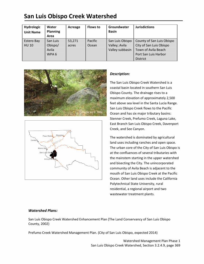
San Luis Obispo Creek Watershed Watershed Management Plan Phase 1 San Luis Obispo Creek Watershed, Section 3.2.4.9, page 369 Hydrologic Unit Name Water Planning Area Acreage Flows to Groundwater Basin Jurisdictions Estero Bay HU 10 San Luis Obispo/ Avila WPA 6 53,271 acres Pacific Ocean San Luis Obispo Valley; Avila Valley subbasin County of San Luis Obispo City of San Luis Obispo Town of Avila Beach Port San Luis Harbor District Description: The San Luis Obispo Creek Watershed is a coastal basin located in southern San Luis Obispo County. The drainage rises to a maximum elevation of approximately 2,500 feet above sea level in the Santa Lucia Range. San Luis Obispo Creek flows to the Pacific Ocean and has six major tributary basins: Stenner Creek, Prefumo Creek, Laguna Lake, East Branch San Luis Obispo Creek, Davenport Creek, and See Canyon. The watershed is dominated by agricultural land uses including ranches and open space. The urban core of the City of San Luis Obispo is at the confluences of several tributaries with the mainstem starting in the upper watershed and bisecting the City. The unincorporated community of Avila Beach is adjacent to the mouth of San Luis Obispo Creek at the Pacific Ocean. Other land uses include the California Polytechnical State University, rural residential, a regional airport and two wastewater treatment plants. Watershed Plans: San Luis Obispo Creek Watershed Enhancement Plan (The Land Conservancy of San Luis Obispo County, 2002) Prefumo Creek Watershed Management Plan. (City of San Luis Obispo, expected 2014) Photo by: F. Otte
Transcript of San Luis Obispo Creek Watershed - SLO Watershed Project · San Luis Obispo Creek Watershed...
San Luis Obispo Creek Watershed
Watershed Management Plan Phase 1 San Luis Obispo Creek Watershed, Section 3.2.4.9, page 369
Hydrologic
Unit Name
Water Planning Area
Acreage Flows to Groundwater Basin
Jurisdictions
Estero Bay HU 10
San Luis Obispo/ Avila WPA 6
53,271 acres
Pacific Ocean
San Luis Obispo Valley; Avila Valley subbasin
County of San Luis Obispo City of San Luis Obispo Town of Avila Beach Port San Luis Harbor District
Description:
The San Luis Obispo Creek Watershed is a
coastal basin located in southern San Luis
Obispo County. The drainage rises to a
maximum elevation of approximately 2,500
feet above sea level in the Santa Lucia Range.
San Luis Obispo Creek flows to the Pacific
Ocean and has six major tributary basins:
Stenner Creek, Prefumo Creek, Laguna Lake,
East Branch San Luis Obispo Creek, Davenport
Creek, and See Canyon.
The watershed is dominated by agricultural
land uses including ranches and open space.
The urban core of the City of San Luis Obispo is
at the confluences of several tributaries with
the mainstem starting in the upper watershed
and bisecting the City. The unincorporated
community of Avila Beach is adjacent to the
mouth of San Luis Obispo Creek at the Pacific
Ocean. Other land uses include the California
Polytechnical State University, rural
residential, a regional airport and two
wastewater treatment plants.
Watershed Plans:
San Luis Obispo Creek Watershed Enhancement Plan (The Land Conservancy of San Luis Obispo County, 2002) Prefumo Creek Watershed Management Plan. (City of San Luis Obispo, expected 2014)
Photo by: F. Otte
San Luis Obispo Creek Watershed
Watershed Management Plan Phase 1 San Luis Obispo Creek Watershed, Section 3.2.4.9, page 370
Characteristics:
Physical Setting
Rainfall 17 – 33 inches (NRCS Precipitation 1981-2010) 24 – 29 inches, Mean Annual (SLO County Water.org)
Air Temperature Summer Range (August 1981-2010): 55 - 77 F
Winter Range (December 1981-2010): 43 - 61 F At Cal Poly San Luis Obispo, CA. (NOAA National Climatic Data Center, viewed 2013)
Geology Description
Stenner Creek consists of steep pre-Quaternary non-infiltrative headwaters and a flat Franciscan low infiltrative valley – category #2. Reservoir Canyon Creek consists of steep moderately infiltrative early to mid-Tertiary headwaters and a flat pre-Quaternary moderately infiltrative valley – category #11. Prefumo Creek consists of steep moderately infiltrative early to mid-Tertiary headwaters; flat youngest Tertiary highly infiltrative valley – category #15. (Bell, personal communication, 2013) East Branch SLO Creek and Davenport Creek consist of flat Franciscan headwaters and flat Quaternary valley. Rock types in the SLO area are mainly comprised of volcanic, metavolcanics and mélanges of serpentinite and greywacke sandstone. These rocks are highly fractured and are part of the Mesozoic aged Franciscan Formation. Intrusive and extrusive volcanic deposits of Tertiary age and marine sedimentary deposits of the Miocene aged Monterey Formation are also found in the area. The most distinctive geomorphological feature of the San Luis Obispo area is the series of Tertiary aged volcanic plugs (remnants of volcanoes) which extend from the City of San Luis Obispo to Morro Bay. Hollister Peak, Bishop Peak, Cerro San Luis Obispo, Islay Hill and Morro Rock are all comprised of these volcanic plugs. (City of SLO, 2010)
Hydrology
Stream Gage Yes; USGS 11142000 Steiner Creek near San Luis Obispo, CA (no data online for this site, inactive) (USGS NWIS, viewed 2013). Andrews Street at San Luis Obispo Creek (2001-present, active); Stenner Creek at Nipomo Street (2001 -present, active); Elks lodge bridge and San Luis Obispo Creek (2001 -present, active); Laguna Lake outflow at Madonna (2001 -present, active); East Fork at Jespersen Bridge (2001 -present, active) (SLOCountyWater.org, viewed 2013). City of SLO Los Osos Valley Road at San Luis Obispo
San Luis Obispo Creek Watershed
Watershed Management Plan Phase 1 San Luis Obispo Creek Watershed, Section 3.2.4.9, page 371
Creek (2004/5, status unknown) (Otte, personal communication, 2013). Historically, at least two stream gauges existed in the San Luis Obispo Creek Watershed that would have been capable of recording flood peaks. One was located on lower San Luis Obispo Creek near Avila, and the other was located on Upper San Luis Obispo Creek, in San Luis Obispo. Unfortunately, both of these gauges were put out of service in 1992. Since that time, the City of San Luis Obispo has re-installed a gauge on Upper San Luis Obispo Creek. However, there is no gauge record for the 1995 water year (Questa Engineering, County of San Luis Obispo, 2003 p C-19).
Hydrologic Models Yes; Questa Engineering for San Luis Obispo Creek Watershed Waterway Management Plan, 2003.
Peak Flow 19,800 cfs San Luis Obispo Creek above See Canyon (FEMA Flood Insurance Study,1978); 22,000 cfs San Luis Obispo Creek at Squire Canyon (Questa/Zone 9 Model); “…, the Corps/Nolte/FEMA study used an actual recorded rainfall event (in this case, the January 19, 1973 event) to define a storm that theoretically represented the maximum precipitation possible for a given part of the watershed.”(Questa Engineering, County of San Luis Obispo, 2003, pC-28).
Base Flow No source identified for measured summer base flows. City of San Luis Obispo Wastewater Treatment Plant is required to discharge a minimum of 2.5 cfs into San Luis Obispo Creek. “A conservative estimate was made by assuming that base flow in the creek during a large storm would be similar to the base flow in the creek that was observed over the week following the storm of March 2, 1983.The average base flow for this time period, omitting days when rainfall occurred, was approximately 14 cms (500 cfs). Divided over the upstream area of 207 km2 (80 mi2) this gives an average base flow rate of 0.067 cms/km2 (6.3 cfs/mi2), which was then applied to each [of 61 individual] sub-basin [formed for the watershed model]. This base flow rate is significantly higher than the long term average winter-season flow rate in San Luis Obispo creek, and is intended to represent the base flow in the creek during a series of wet storms. It is much greater than any likely winter time releases from the City of San Luis Obispo Water Reclamation Facility, which discharges into San Luis Obispo Creek downstream from the Prado Road Bridge.”(Questa Engineering, 2003, pC-8)
Flood Report Yes; San Luis Obispo Creek Waterway Management Plan (Questa Engineering, 2003). The City manages several flood by-pass channels along SLO Creek
San Luis Obispo Creek Watershed
Watershed Management Plan Phase 1 San Luis Obispo Creek Watershed, Section 3.2.4.9, page 372
and Laguna Lake for flood control. (Otte, personal communication, 2013) Areas of flood risk include Highway 101 near Los Osos Valley Road (LOVR) and extends extends up Prefumo Creek to Calle Joaquin; San Luis Obispo Creek near Elks Lane; between Marsh Street and Madonna Road; San Luis Obispo Creek above Cuesta Park; across Santa Rosa Street and through a residential neighborhood toward Chorro Street and Old Garden Creek; East Fork of SLO Creek at Buckley Road.(Questa Engineering, 2003, p78-84)
Biological Setting
Vegetation Cover Primarily non-native grassland with some chaparral (chamise, leather oak, mixed serpentine), coastal scrub, coastal live oak forest, agricultural land and urban land. (SLO County, vegetation shapefile, 1990) SLO Creek is dominated by a willow (Salix spp.) riparian canopy with a mixture of oaks, sycamore, and cottonwood trees making up the rest of the native canopy. The understory consists of blackberry vines, coyotebrush, sage species, coffee berry, toyon, elderberry and a large number of ornamental non-native species (Questa Engineering, 2003). Mixed chaparral found near Cuesta grade contains several species of manzanita, many of which are endemic and rare. (Althouse and Meade, Inc, 2013) Limited current spatial data. No alliance level vegetation mapping was available for the entire County.
Invasive Species Arundo donax (Giant Reed), Delairea oderata (Cape Ivy), poison hemlock (Conium maculatum), tree of heaven (Ailanthus altissima), several species of eucalyptus, and castor bean (Ricinus communis). Other various weeds including anise, cocklebur, yellow star thistle, milk thistle and Italian thistle (Land Conservancy, 2002). There are non-native palm trees and myoporum and other ornamental escapee’s which have colonized the creek channel. Himalayan blackberry, kikuyu grass, vinca, pampas grass, French and Spanish broom, English ivy, and bullfrogs. (Otte, personal communication, 2013) Limited spatial data.
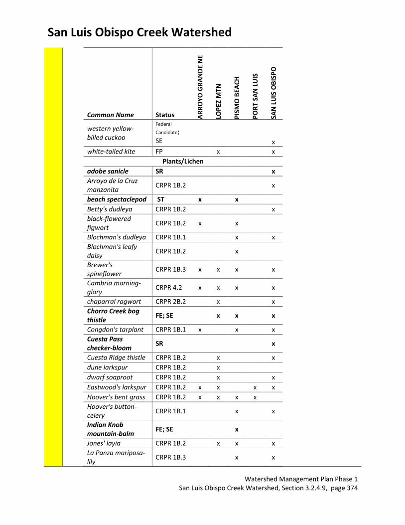
Special Status Wildlife and Plants
Key: FE - Federal endangered, FT - Federal threatened, SE - State endangered, ST - State threatened, SSC - State Species of Special Concern; FP- Fully Protected, SA – Special Animal, CRPR – CA rare plant rank (CNDDB, viewed August, 2013) Locations listed refer to USGS 7.5’ quadrangle names. Only the

San Luis Obispo Creek Watershed
Watershed Management Plan Phase 1 San Luis Obispo Creek Watershed, Section 3.2.4.9, page 373
portion overlapping the watershed boundary was considered. Limited by the type of data collected in the CA Natural Diversity Database.
Common Name Status AR
RO
YO
GR
AN
DE
NE
LOP
EZ M
TN
PIS
MO
BEA
CH
PO
RT
SAN
LU
IS
SAN
LU
IS O
BIS
PO
Animals
American badger SSC x x x
Atascadero June beetle
SA x
black legless lizard SSC x
California red-legged frog
FT x x x x
coast horned lizard SSC x x
Coast Range newt SSC x x
ferruginous hawk SA (Wintering)
x
foothill yellow-legged frog
SSC x x
globose dune beetle SA x
loggerhead shrike SSC (Nesting)
x x
monarch butterfly SA x x
pallid bat SSC x
prairie falcon SA (Nesting) x x x x
San Luis Obispo pyrg SA x x
sandy beach tiger beetle
SA x
silvery legless lizard SSC x
steelhead - south/central California coast DPS
FT x x x x
tidewater goby FE x
vernal pool fairy shrimp
FT x x
western mastiff bat SSC x
western pond turtle SSC x x x x
western snowy plover
FT x
San Luis Obispo Creek Watershed
Watershed Management Plan Phase 1 San Luis Obispo Creek Watershed, Section 3.2.4.9, page 374
Common Name Status AR
RO
YO
GR
AN
DE
NE
LOP
EZ M
TN
PIS
MO
BEA
CH
PO
RT
SAN
LU
IS
SAN
LU
IS O
BIS
PO
western yellow-billed cuckoo
Federal
Candidate; SE
x
white-tailed kite FP x x
Plants/Lichen
adobe sanicle SR x
Arroyo de la Cruz manzanita
CRPR 1B.2 x
beach spectaclepod ST x x
Betty's dudleya CRPR 1B.2 x
black-flowered figwort
CRPR 1B.2 x x
Blochman's dudleya CRPR 1B.1 x x
Blochman's leafy daisy
CRPR 1B.2 x
Brewer's spineflower
CRPR 1B.3 x x x x
Cambria morning-glory
CRPR 4.2 x x x x
chaparral ragwort CRPR 2B.2 x x
Chorro Creek bog thistle
FE; SE x x x
Congdon's tarplant CRPR 1B.1 x x x
Cuesta Pass checker-bloom
SR x
Cuesta Ridge thistle CRPR 1B.2 x x
dune larkspur CRPR 1B.2 x
dwarf soaproot CRPR 1B.2 x x
Eastwood's larkspur CRPR 1B.2 x x x x
Hoover's bent grass CRPR 1B.2 x x x x
Hoover's button-celery
CRPR 1B.1 x x
Indian Knob mountain-balm
FE; SE x
Jones' layia CRPR 1B.2 x x x
La Panza mariposa-lily
CRPR 1B.3 x x

San Luis Obispo Creek Watershed
Watershed Management Plan Phase 1 San Luis Obispo Creek Watershed, Section 3.2.4.9, page 375
Common Name Status AR
RO
YO
GR
AN
DE
NE
LOP
EZ M
TN
PIS
MO
BEA
CH
PO
RT
SAN
LU
IS
SAN
LU
IS O
BIS
PO
marsh sandwort FE; SE x x
mesa horkelia CRPR 1B.1 x x x
Miles' milk-vetch CRPR 1B.2 x
Morro manzanita FT x x x
most beautiful jewel-flower
CRPR 1B.2 x x x
mouse-gray dudleya CRPR 1B.3 x x x x
Palmer's monardella CRPR 1B.2 x x
Pecho manzanita CRPR 1B.2 x x x
Pismo clarkia FE; SR x x
saline clover CRPR 1B.2 x
San Benito fritillary CRPR 1B.2 x
San Luis mariposa-lily
CRPR 1B.2 x x x x
San Luis Obispo owl's-clover
CRPR 1B.2 x
San Luis Obispo County lupine
CRPR 1B.2 x x
San Luis Obispo owl's-clover
CRPR 1B.2 x x x x
San Luis Obispo sedge
CRPR 1B.2 x x
Santa Lucia manzanita
CRPR 1B.2 x x x
Santa Margarita manzanita
CRPR 1B.2 x x x x x
straight-awned spineflower
CRPR 1B.3 x
surf thistle ST x x
Steelhead Streams San Luis Obispo Creek, San Miguelito (See Canyon) Creek, Froom Creek, Prefumo Creek, Stenner Creek, Brizzolari Creek, Unnamed tributary (NMFS, 2005). Dry Creek, Acacia Creek, Reservoir Canyon (Otte, personal communication, 2013).
Stream Habitat Inventory
Yes; Completed in 1995 by Paul Cleveland on mainstem San Luis Obispo Creek. (Land Conservancy, 2002) Limited data that does not include major tributaries. Last data collected in mid 1990’s.
San Luis Obispo Creek Watershed
Watershed Management Plan Phase 1 San Luis Obispo Creek Watershed, Section 3.2.4.9, page 376
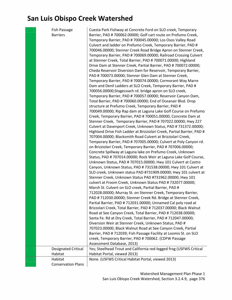
Fish Passage Barriers
Cuesta Park Fishway at Concrete Ford on SLO creek, Temporary Barrier, PAD # 700062.00000; Golf cart route on Prefumo Creek, Temporary Barrier, PAD # 700045.00000; Los Osos Valley Road Culvert and ladder on Prefumo Creek, Temporary Barrier, PAD # 700046.00000; Stenner Creek Road Bridge Apron on Stenner Creek, Temporary Barrier, PAD # 700069.00000; Railroad Crossing Culvert at Stenner Creek, Total Barrier, PAD # 700071.00000; Highland Drive Dam at Stenner Creek, Partial Barrier, PAD # 700072.00000; Cheda Reservoir Diversion Dam for Reservoir, Temporary Barrier, PAD # 700073.00000; Stenner Glen Dam at Stenner Creek, Temporary Barrier, PAD # 700074.00000; Cormorant Way Marre Dam and Denil Ladders at SLO Creek, Temporary Barrier, PAD # 700056.00000;Stagecoach rd. bridge apron on SLO creek, Temporary Barrier, PAD # 700057.00000; Reservoir Canyon Dam, Total Barrier, PAD # 700060.00000; End of Oceanair Blvd. Drop structure at Prefumo Creek, Temporary Barrier, PAD # 700049.00000; Rip Rap dam at Laguna Lake Golf Course on Prefumo Creek, Temporary Barrier, PAD # 700051.00000; Concrete Dam at Stenner Creek, Temporary Barrier, PAD # 707022.00000; Hwy 227 Culvert at Davenport Creek, Unknown Status, PAD # 731372.00000; Highland Drive Fish Ladder at Brizziolari Creek, Partial Barrier, PAD # 707004.00000; Blacksmith Road Culvert at Brizziolari Creek, Temporary Barrier, PAD # 707005.00000; Culvert at Poly Canyon rd. on Brizziolari Creek, Temporary Barrier, PAD # 707006.00000; Concrete Spillway at Laguna lake on Prefumo Creek, Unknown Status, PAD # 707014.00000; Rock Weir at Laguna Lake Golf Course, Unknown Status, PAD # 707015.00000; Hwy 101 Culvert at Castro Canyon, Unknown Status, PAD # 731538.00000; Hwy 101 Culvert at SLO creek, Unknown status PAD #731909.00000; Hwy 101 culvert at Stenner Creek, Unknown Status PAD #731962.00000; Hwy 101 culvert at Froom Creek, Unknown Status PAD # 732077.00000; Marsh St. Culvert on SLO creek, Partial Barrier, PAD # 712028.00000; Murray St. on Stenner Creek, Temporary Barrier, PAD # 712030.00000; Stenner Creek Rd. Bridge at Stenner Creek, Partial Barrier, PAD # 712031.00000; Unnamed Cal poly road at Brizzolari Creek, Total Barrier, PAD # 712037.00000; Black Walnut Road at See Canyon Creek, Total Barrier, PAD # 712038.00000; Santa Fe. Rd at Dry Creek, Total Barrier, PAD # 712047.00000; Diversion Weir at Stenner Creek, Unknown Status, PAD # 707023.00000; Black Walnut Road at See Canyon Creek, Partial Barrier, PAD # 712039; Fish Passage Facility at Loomis St. on SLO creek, Temporary Barrier, PAD # 700062. (CDFW Passage Assessment Database, 2013)
Designated Critical Habitat
Yes; Steelhead Trout and California red-legged frog (USFWS Critical Habitat Portal, viewed 2013)
Habitat Conservation Plans
None. (USFWS Critical Habitat Portal, viewed 2013)
San Luis Obispo Creek Watershed
Watershed Management Plan Phase 1 San Luis Obispo Creek Watershed, Section 3.2.4.9, page 377
Other Environmental Resources
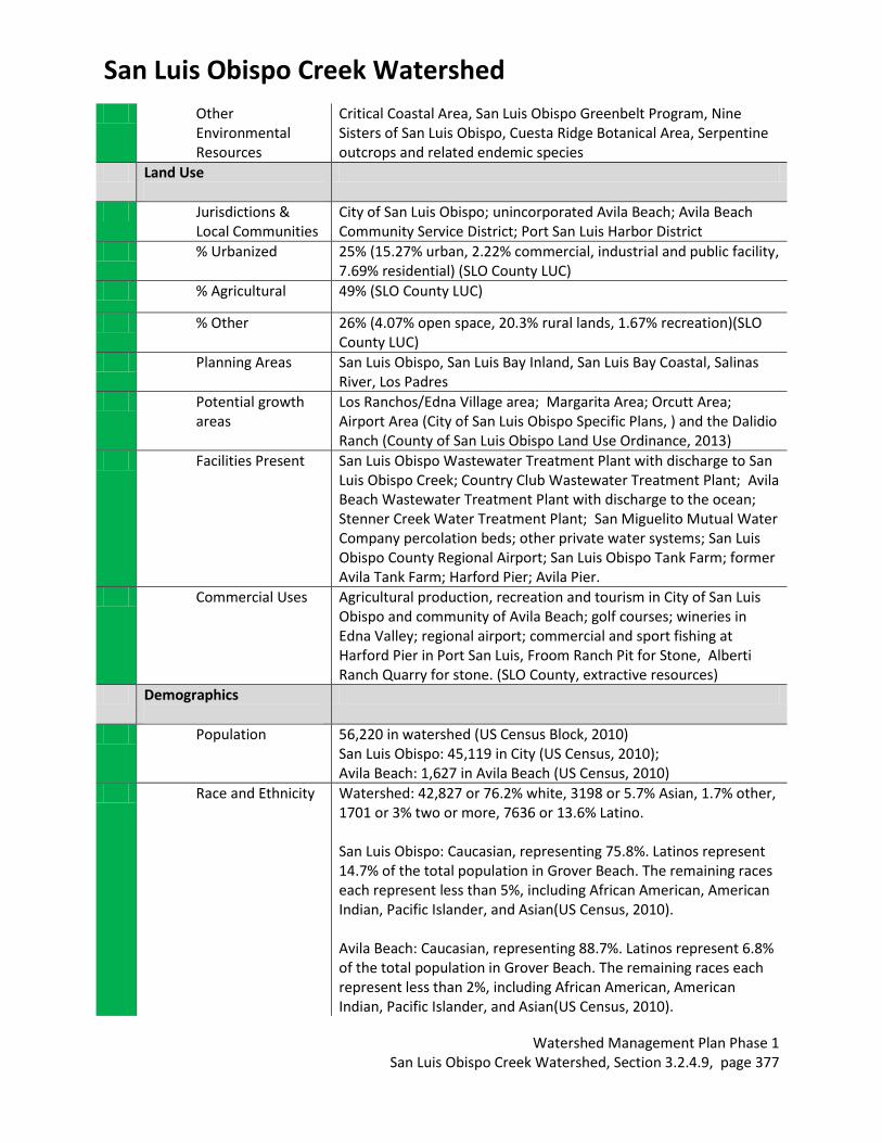
Critical Coastal Area, San Luis Obispo Greenbelt Program, Nine Sisters of San Luis Obispo, Cuesta Ridge Botanical Area, Serpentine outcrops and related endemic species
Land Use
Jurisdictions & Local Communities
City of San Luis Obispo; unincorporated Avila Beach; Avila Beach Community Service District; Port San Luis Harbor District
% Urbanized 25% (15.27% urban, 2.22% commercial, industrial and public facility, 7.69% residential) (SLO County LUC)
% Agricultural 49% (SLO County LUC)
% Other 26% (4.07% open space, 20.3% rural lands, 1.67% recreation)(SLO County LUC)
Planning Areas San Luis Obispo, San Luis Bay Inland, San Luis Bay Coastal, Salinas River, Los Padres
Potential growth areas
Los Ranchos/Edna Village area; Margarita Area; Orcutt Area; Airport Area (City of San Luis Obispo Specific Plans, ) and the Dalidio Ranch (County of San Luis Obispo Land Use Ordinance, 2013)
Facilities Present San Luis Obispo Wastewater Treatment Plant with discharge to San Luis Obispo Creek; Country Club Wastewater Treatment Plant; Avila Beach Wastewater Treatment Plant with discharge to the ocean; Stenner Creek Water Treatment Plant; San Miguelito Mutual Water Company percolation beds; other private water systems; San Luis Obispo County Regional Airport; San Luis Obispo Tank Farm; former Avila Tank Farm; Harford Pier; Avila Pier.
Commercial Uses Agricultural production, recreation and tourism in City of San Luis Obispo and community of Avila Beach; golf courses; wineries in Edna Valley; regional airport; commercial and sport fishing at Harford Pier in Port San Luis, Froom Ranch Pit for Stone, Alberti Ranch Quarry for stone. (SLO County, extractive resources)
Demographics
Population 56,220 in watershed (US Census Block, 2010) San Luis Obispo: 45,119 in City (US Census, 2010); Avila Beach: 1,627 in Avila Beach (US Census, 2010)
Race and Ethnicity Watershed: 42,827 or 76.2% white, 3198 or 5.7% Asian, 1.7% other, 1701 or 3% two or more, 7636 or 13.6% Latino. San Luis Obispo: Caucasian, representing 75.8%. Latinos represent 14.7% of the total population in Grover Beach. The remaining races each represent less than 5%, including African American, American Indian, Pacific Islander, and Asian(US Census, 2010). Avila Beach: Caucasian, representing 88.7%. Latinos represent 6.8% of the total population in Grover Beach. The remaining races each represent less than 2%, including African American, American Indian, Pacific Islander, and Asian(US Census, 2010).
San Luis Obispo Creek Watershed
Watershed Management Plan Phase 1 San Luis Obispo Creek Watershed, Section 3.2.4.9, page 378
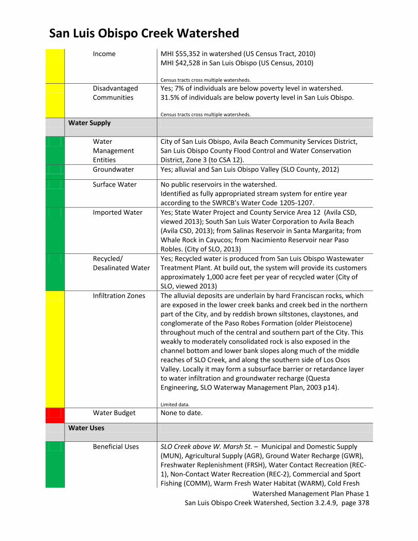
Income MHI $55,352 in watershed (US Census Tract, 2010) MHI $42,528 in San Luis Obispo (US Census, 2010) Census tracts cross multiple watersheds.
Disadvantaged Communities
Yes; 7% of individuals are below poverty level in watershed. 31.5% of individuals are below poverty level in San Luis Obispo. Census tracts cross multiple watersheds.
Water Supply
Water Management Entities
City of San Luis Obispo, Avila Beach Community Services District, San Luis Obispo County Flood Control and Water Conservation District, Zone 3 (to CSA 12).
Groundwater Yes; alluvial and San Luis Obispo Valley (SLO County, 2012)
Surface Water No public reservoirs in the watershed. Identified as fully appropriated stream system for entire year according to the SWRCB’s Water Code 1205-1207.
Imported Water Yes; State Water Project and County Service Area 12 (Avila CSD, viewed 2013); South San Luis Water Corporation to Avila Beach (Avila CSD, 2013); from Salinas Reservoir in Santa Margarita; from Whale Rock in Cayucos; from Nacimiento Reservoir near Paso Robles. (City of SLO, 2013)
Recycled/ Desalinated Water
Yes; Recycled water is produced from San Luis Obispo Wastewater Treatment Plant. At build out, the system will provide its customers approximately 1,000 acre feet per year of recycled water (City of SLO, viewed 2013)
Infiltration Zones The alluvial deposits are underlain by hard Franciscan rocks, which are exposed in the lower creek banks and creek bed in the northern part of the City, and by reddish brown siltstones, claystones, and conglomerate of the Paso Robes Formation (older Pleistocene) throughout much of the central and southern part of the City. This weakly to moderately consolidated rock is also exposed in the channel bottom and lower bank slopes along much of the middle reaches of SLO Creek, and along the southern side of Los Osos Valley. Locally it may form a subsurface barrier or retardance layer to water infiltration and groundwater recharge (Questa Engineering, SLO Waterway Management Plan, 2003 p14). Limited data.
Water Budget None to date.
Water Uses
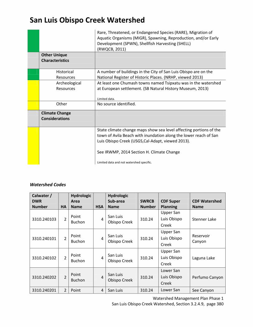
Beneficial Uses SLO Creek above W. Marsh St. – Municipal and Domestic Supply (MUN), Agricultural Supply (AGR), Ground Water Recharge (GWR), Freshwater Replenishment (FRSH), Water Contact Recreation (REC-1), Non-Contact Water Recreation (REC-2), Commercial and Sport Fishing (COMM), Warm Fresh Water Habitat (WARM), Cold Fresh

San Luis Obispo Creek Watershed
Watershed Management Plan Phase 1 San Luis Obispo Creek Watershed, Section 3.2.4.9, page 379
Water Habitat (COLD) , Wildlife Habitat (WILD), Rare, Threatened, or Endangered Species (RARE), Migration of Aquatic Organisms (MIGR), Spawning, Reproduction, and/or Early Development (SPWN). SLO Creek below W. Marsh St. – Municipal and Domestic Supply (MUN), Agricultural Supply (AGR), Industrial Service Supply (IND), Ground Water Recharge (GWR), Freshwater Replenishment (FRSH), Water Contact Recreation (REC-1), Non-Contact Water Recreation (REC-2), Commercial and Sport Fishing (COMM), Warm Fresh Water Habitat (WARM), Cold Fresh Water Habitat (COLD) , Wildlife Habitat (WILD), Preservation of Biological Habitats of Special Significance (BIOL), Migration of Aquatic Organisms (MIGR), Spawning, Reproduction, and/or Early Development (SPWN). SLO Creek East Fork– Municipal and Domestic Supply (MUN), Agricultural Supply (AGR), Ground Water Recharge (GWR), Freshwater Replenishment (FRSH), Water Contact Recreation (REC-1), Non-Contact Water Recreation (REC-2), Commercial and Sport Fishing (COMM), Cold Fresh Water Habitat (COLD) , Wildlife Habitat (WILD), Rare, Threatened, or Endangered Species (RARE), Migration of Aquatic Organisms (MIGR), Spawning, Reproduction, and/or Early Development (SPWN). Stenner Creek – Municipal and Domestic Supply (MUN), Agricultural Supply (AGR), Ground Water Recharge (GWR), Freshwater Replenishment (FRSH), Water Contact Recreation (REC-1), Non-Contact Water Recreation (REC-2), Commercial and Sport Fishing (COMM), Cold Fresh Water Habitat (COLD) , Wildlife Habitat (WILD), Rare, Threatened, or Endangered Species (RARE), Migration of Aquatic Organisms (MIGR), Spawning, Reproduction, and/or Early Development (SPWN). Prefumo Creek – Municipal and Domestic Supply (MUN), Agricultural Supply (AGR), Ground Water Recharge (GWR), Freshwater Replenishment (FRSH), Water Contact Recreation (REC-1), Non-Contact Water Recreation (REC-2), Commercial and Sport Fishing (COMM), Cold Fresh Water Habitat (COLD) , Wildlife Habitat (WILD), Rare, Threatened, or Endangered Species (RARE), Migration of Aquatic Organisms (MIGR), Spawning, Reproduction, and/or Early Development (SPWN). SLO Creek Estuary – Ground Water Recharge (GWR), Water Contact Recreation (REC-1), Non-Contact Water Recreation (REC-2), Commercial and Sport Fishing (COMM), Cold Fresh Water Habitat (COLD), Estuarine Habitat (EST), Wildlife Habitat (WILD), Preservation of Biological Habitats of Special Significance (BIOL),
San Luis Obispo Creek Watershed
Watershed Management Plan Phase 1 San Luis Obispo Creek Watershed, Section 3.2.4.9, page 380
Rare, Threatened, or Endangered Species (RARE), Migration of Aquatic Organisms (MIGR), Spawning, Reproduction, and/or Early Development (SPWN), Shellfish Harvesting (SHELL) (RWQCB, 2011)
Other Unique Characteristics
Historical Resources
A number of buildings in the City of San Luis Obispo are on the National Register of Historic Places. (NRHP, viewed 2013)
Archeological Resources
At least one Chumash towns named Tsipxatu was in the watershed at European settlement. (SB Natural History Museum, 2013) Limited data.
Other No source identified.
Climate Change Considerations
State climate change maps show sea level affecting portions of the town of Avila Beach with inundation along the lower reach of San Luis Obispo Creek (USGS,Cal-Adapt, viewed 2013). See IRWMP, 2014 Section H. Climate Change Limited data and not watershed specific.
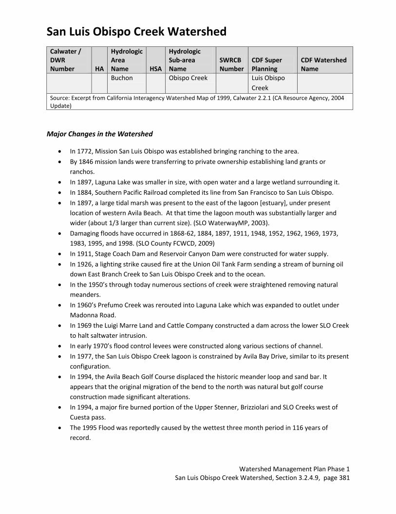
Watershed Codes
Calwater / DWR Number HA
Hydrologic Area Name HSA
Hydrologic Sub-area Name
SWRCB Number
CDF Super Planning
CDF Watershed Name
3310.240103 2 Point Buchon
4 San Luis Obispo Creek
310.24
Upper San
Luis Obispo
Creek
Stenner Lake
3310.240101 2 Point Buchon
4 San Luis Obispo Creek
310.24
Upper San
Luis Obispo
Creek
Reservoir Canyon
3310.240102 2 Point Buchon
4 San Luis Obispo Creek
310.24
Upper San
Luis Obispo
Creek
Laguna Lake
3310.240202 2 Point Buchon
4 San Luis Obispo Creek
310.24
Lower San
Luis Obispo
Creek
Perfumo Canyon
3310.240201 2 Point 4 San Luis 310.24 Lower San See Canyon
San Luis Obispo Creek Watershed
Watershed Management Plan Phase 1 San Luis Obispo Creek Watershed, Section 3.2.4.9, page 381
Calwater / DWR Number HA
Hydrologic Area Name HSA
Hydrologic Sub-area Name
SWRCB Number
CDF Super Planning
CDF Watershed Name
Buchon Obispo Creek Luis Obispo
Creek
Source: Excerpt from California Interagency Watershed Map of 1999, Calwater 2.2.1 (CA Resource Agency, 2004 Update)
Major Changes in the Watershed
In 1772, Mission San Luis Obispo was established bringing ranching to the area.
By 1846 mission lands were transferring to private ownership establishing land grants or
ranchos.
In 1897, Laguna Lake was smaller in size, with open water and a large wetland surrounding it.
In 1884, Southern Pacific Railroad completed its line from San Francisco to San Luis Obispo.
In 1897, a large tidal marsh was present to the east of the lagoon [estuary], under present
location of western Avila Beach. At that time the lagoon mouth was substantially larger and
wider (about 1/3 larger than current size). (SLO WaterwayMP, 2003).
Damaging floods have occurred in 1868-62, 1884, 1897, 1911, 1948, 1952, 1962, 1969, 1973,
1983, 1995, and 1998. (SLO County FCWCD, 2009)
In 1911, Stage Coach Dam and Reservoir Canyon Dam were constructed for water supply.
In 1926, a lighting strike caused fire at the Union Oil Tank Farm sending a stream of burning oil
down East Branch Creek to San Luis Obispo Creek and to the ocean.
In the 1950’s through today numerous sections of creek were straightened removing natural
meanders.
In 1960’s Prefumo Creek was rerouted into Laguna Lake which was expanded to outlet under
Madonna Road.
In 1969 the Luigi Marre Land and Cattle Company constructed a dam across the lower SLO Creek
to halt saltwater intrusion.
In early 1970’s flood control levees were constructed along various sections of channel.
In 1977, the San Luis Obispo Creek lagoon is constrained by Avila Bay Drive, similar to its present
configuration.
In 1994, the Avila Beach Golf Course displaced the historic meander loop and sand bar. It
appears that the original migration of the bend to the north was natural but golf course
construction made significant alterations.
In 1994, a major fire burned portion of the Upper Stenner, Brizziolari and SLO Creeks west of
Cuesta pass.
The 1995 Flood was reportedly caused by the wettest three month period in 116 years of
record.
San Luis Obispo Creek Watershed
Watershed Management Plan Phase 1 San Luis Obispo Creek Watershed, Section 3.2.4.9, page 382
In 1996, the Natural Resources Program is formed at the City of San Luis Obispo. Habitat
improvements, barrier removal, invasive species control, erosion control, open space protection
and acquisition.
Watershed Health by Major Tributary Tributary Name Ephemeral /
Perennial 303d Listed/ TMDLs
Pollution Sources
Environmental Flows
San Luis Obispo
Creek (below Osos
Street)
Perennial Yes on 303d list for Chloride, Chlorpyrifos, Nitrate, Nutrients, Pathogens, Sodium. Approved USEPA TMDLs for Pathogens in 2004, for Nutrients in 2007 and for Nitrates in 2007. TMDL estimated date of completion 2021. (SWRCB, 2010)
Agriculture, Grazing Related, Natural, Major Municipal Point Source, Transient Encampments, Urban Runoff, Upstream Impoundment (SWRCB, 2010)
Table 3 of Instream Flow Assessment (Stillwater Sciences, 2013)
San Luis Obispo Creek (above Osos Street)
Yes on 303d list for Fecal Coliform. TMDL estimated date of completion 2021. (SWRCB, 2010)
Unknown (SWRCB, 2010); Pigeons, Transients, Cattle grazing, Natural sources, Urban Runoff (Otte, personal communication, 2013)
Table 3 of Instream Flow Assessment (Stillwater Sciences, 2013)
Stenner Creek Partially Perennial Yes on 303d list for Fecal Coliform. TMDL estimated date of completion 2021. (SWRCB, 2010)
Agriculture, Grazing Related, Natural, Urban Runoff (SWRCB, 2010)
Table 3 of Instream Flow Assessment (Stillwater Sciences, 2013)
Davenport Creek Ephemeral No. (SWRCB, 2010)
Undetermined. No source identified.
East Fork San Luis Ephemeral No. (SWRCB, Undetermined. Table 3 of
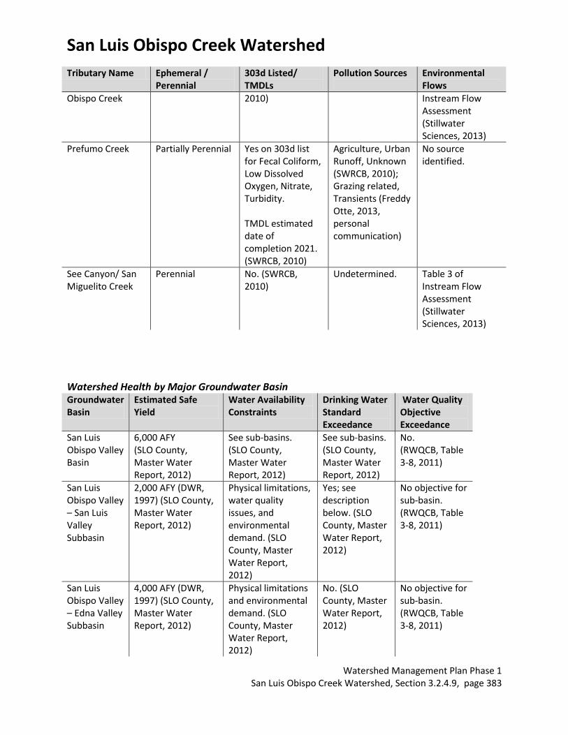
San Luis Obispo Creek Watershed
Watershed Management Plan Phase 1 San Luis Obispo Creek Watershed, Section 3.2.4.9, page 383
Tributary Name Ephemeral / Perennial
303d Listed/ TMDLs
Pollution Sources
Environmental Flows
Obispo Creek
2010) Instream Flow Assessment (Stillwater Sciences, 2013)
Prefumo Creek Partially Perennial Yes on 303d list for Fecal Coliform, Low Dissolved Oxygen, Nitrate, Turbidity. TMDL estimated date of completion 2021. (SWRCB, 2010)
Agriculture, Urban Runoff, Unknown (SWRCB, 2010); Grazing related, Transients (Freddy Otte, 2013, personal communication)
No source identified.
See Canyon/ San Miguelito Creek
Perennial No. (SWRCB, 2010)
Undetermined. Table 3 of Instream Flow Assessment (Stillwater Sciences, 2013)
Watershed Health by Major Groundwater Basin Groundwater Basin
Estimated Safe Yield
Water Availability Constraints
Drinking Water Standard Exceedance
Water Quality Objective Exceedance
San Luis Obispo Valley Basin
6,000 AFY (SLO County, Master Water Report, 2012)
See sub-basins. (SLO County, Master Water Report, 2012)
See sub-basins. (SLO County, Master Water Report, 2012)
No. (RWQCB, Table 3-8, 2011)
San Luis Obispo Valley – San Luis Valley Subbasin
2,000 AFY (DWR, 1997) (SLO County, Master Water Report, 2012)
Physical limitations, water quality issues, and environmental demand. (SLO County, Master Water Report, 2012)
Yes; see description below. (SLO County, Master Water Report, 2012)
No objective for sub-basin. (RWQCB, Table 3-8, 2011)
San Luis Obispo Valley – Edna Valley Subbasin
4,000 AFY (DWR, 1997) (SLO County, Master Water Report, 2012)
Physical limitations and environmental demand. (SLO County, Master Water Report, 2012)
No. (SLO County, Master Water Report, 2012)
No objective for sub-basin. (RWQCB, Table 3-8, 2011)
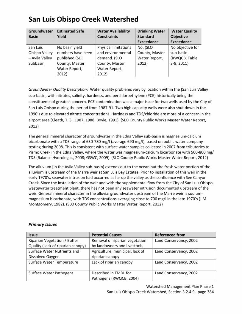
San Luis Obispo Creek Watershed
Watershed Management Plan Phase 1 San Luis Obispo Creek Watershed, Section 3.2.4.9, page 384
Groundwater Basin
Estimated Safe Yield
Water Availability Constraints
Drinking Water Standard Exceedance
Water Quality Objective Exceedance
San Luis Obispo Valley – Avila Valley Subbasin
No basin yield numbers have been published (SLO County, Master Water Report, 2012)
Physical limitations and environmental demand. (SLO County, Master Water Report, 2012)
No. (SLO County, Master Water Report, 2012)
No objective for sub-basin. (RWQCB, Table 3-8, 2011)
Groundwater Quality Description: Water quality problems vary by location within the [San Luis Valley
sub-basin, with nitrates, salinity, hardness, and perchloroethylene (PCE) historically being the
constituents of greatest concern. PCE contamination was a major issue for two wells used by the City of
San Luis Obispo during the period from 1987-91. Two high capacity wells were also shut down in the
1990’s due to elevated nitrate concentrations. Hardness and TDS/chloride are more of a concern in the
airport area (Cleath, T. S., 1987, 1988; Boyle, 1991). (SLO County Public Works Master Water Report,
2012)
The general mineral character of groundwater in the Edna Valley sub-basin is magnesium-calcium bicarbonate with a TDS range of 630-780 mg/l (average 690 mg/l), based on public water company testing during 2008. This is consistent with surface water samples collected in 2007 from tributaries to Pismo Creek in the Edna Valley, where the water was magnesium-calcium bicarbonate with 500-800 mg/ TDS (Balance Hydrologics, 2008; GSWC, 2009). (SLO County Public Works Master Water Report, 2012)
The alluvium [in the Avila Valley sub-basin] extends out to the ocean but the fresh water portion of the alluvium is upstream of the Marre weir at San Luis Bay Estates. Prior to installation of this weir in the early 1970’s, seawater intrusion had occurred as far up the valley as the confluence with See Canyon Creek. Since the installation of the weir and with the supplemental flow from the City of San Luis Obispo wastewater treatment plant, there has not been any seawater intrusion documented upstream of the weir. General mineral character in the alluvial groundwater upstream of the Marre weir is sodium-magnesium bicarbonate, with TDS concentrations averaging close to 700 mg/l in the late 1970’s (J.M. Montgomery, 1982). (SLO County Public Works Master Water Report, 2012)
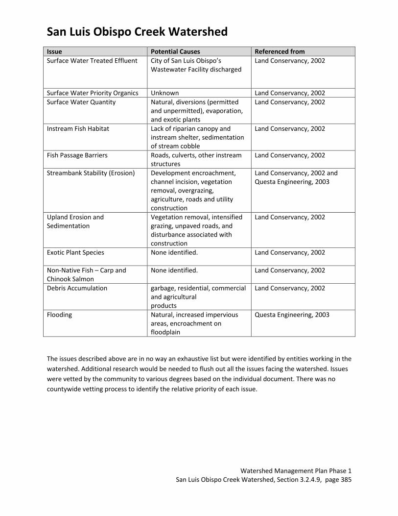
Primary Issues
Issue Potential Causes Referenced from
Riparian Vegetation / Buffer Quality (Lack of riparian canopy)
Removal of riparian vegetation by landowners and livestock,
Land Conservancy, 2002
Surface Water Nutrients and Dissolved Oxygen
Agriculture, municipal, lack of riparian canopy
Land Conservancy, 2002
Surface Water Temperature Lack of riparian canopy
Land Conservancy, 2002
Surface Water Pathogens Described in TMDL for Pathogens (RWQCB, 2004)
Land Conservancy, 2002
San Luis Obispo Creek Watershed
Watershed Management Plan Phase 1 San Luis Obispo Creek Watershed, Section 3.2.4.9, page 385
Issue Potential Causes Referenced from
Surface Water Treated Effluent City of San Luis Obispo’s Wastewater Facility discharged
Land Conservancy, 2002
Surface Water Priority Organics Unknown Land Conservancy, 2002
Surface Water Quantity Natural, diversions (permitted and unpermitted), evaporation, and exotic plants
Land Conservancy, 2002
Instream Fish Habitat Lack of riparian canopy and instream shelter, sedimentation of stream cobble
Land Conservancy, 2002
Fish Passage Barriers Roads, culverts, other instream structures
Land Conservancy, 2002
Streambank Stability (Erosion) Development encroachment, channel incision, vegetation removal, overgrazing, agriculture, roads and utility construction
Land Conservancy, 2002 and Questa Engineering, 2003
Upland Erosion and Sedimentation
Vegetation removal, intensified grazing, unpaved roads, and disturbance associated with construction
Land Conservancy, 2002
Exotic Plant Species None identified.
Land Conservancy, 2002
Non-Native Fish – Carp and Chinook Salmon
None identified. Land Conservancy, 2002
Debris Accumulation garbage, residential, commercial and agricultural products
Land Conservancy, 2002
Flooding Natural, increased impervious areas, encroachment on floodplain
Questa Engineering, 2003
The issues described above are in no way an exhaustive list but were identified by entities working in the
watershed. Additional research would be needed to flush out all the issues facing the watershed. Issues
were vetted by the community to various degrees based on the individual document. There was no
countywide vetting process to identify the relative priority of each issue.
San Luis Obispo Creek Watershed
Watershed Management Plan Phase 1 San Luis Obispo Creek Watershed, Section 3.2.4.9, page 386
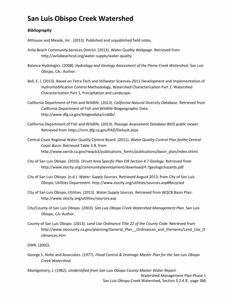
Bibliography
Althouse and Meade, Inc . (2013). Published and unpublished field notes.
Avila Beach Community Services District. (2013). Water Quality Webpage. Retrieved from
http://avilabeachcsd.org/water-supply/water-quality
Balance Hydologics. (2008). Hydrology and Geology Assessment of the Pismo Creek Watershed. San Luis
Obispo, CA.: Author.
Bell, E. (. (2013). Based on Tetra Tech and Stillwater Sciences-2011 Development and Implementation of
Hydromodification Control Methodology, Watershed Characterization Part 1: Watershed
Characterization Part 1, Precipitation and Landscape.
California Department of Fish and Wildlife. (2013). California Natural Diversity Database. Retrieved from
California Department of Fish and Wildlife-Biogeographic Data:
http://www.dfg.ca.gov/biogeodata/cnddb/
California Department of Fish and Wildlife. (2013). Passage Assessment Database BIOS public viewer.
Retrieved from https://nrm.dfg.ca.gov/PAD/Default.aspx
Central Coast Regional Water Quality Control Board. (2011). Water Quality Control Plan forthe Central
Coast Basin. Retrieved Table 3-8, from
http://www.swrcb.ca.gov/rwqcb3/publications_forms/publications/basin_plan/index.shtml.
City of San Luis Obispo. (2010). Orcutt Area Specific Plan EIR Section 4.7 Geology. Retrieved from
http://www.slocity.org/communitydevelopment/download/4.7geologichazards.pdf
City of San Luis Obispo. (n.d.). Water: Supply Sources. Retrieved August 2013, from City of San Luis
Obispo, Utilities Department: http://www.slocity.org/utilities/sources.asp#Recycled
City of San Luis Obispo, Utilities. (2013). Water:Supply Sources. Retrieved from WQCB Basin Plan:
http://www.slocity.org/utilities/sources.asp
City/County of San Luis Obispo. (2003). San Luis Obispo Creek Watershed Management Plan. San Luis
Obispo, CA: Author.
County of San Luis Obispo. (2013). Land Use Ordinance Title 22 of the County Code. Retrieved from
http://www.slocounty.ca.gov/planning/General_Plan__Ordinances_and_Elements/Land_Use_O
rdinances.htm
DWR. (2002).
George S. Nolte and Associates. (1977). Flood Control & Drainage Master Plan for the San Luis Obispo
Creek Watershed.
Montgomery, J. (1982). Unidentified from San Luis Obispo County Master Water Report.
San Luis Obispo Creek Watershed
Watershed Management Plan Phase 1 San Luis Obispo Creek Watershed, Section 3.2.4.9, page 387
National Marine Fisheries Services, S. R. (2009, July). Southern California Steelhead Recovery Plan, Public
Draft. Retrieved from
http://swr.nmfs.noaa.gov/recovery/So_Cal/Southern_California_Steelhead_Public_Draft_Recov
ery_Plan.pdf
National Register of Historic Places. (2013). NPS Focus. Retrieved 2013, from National Register of
Historic Places: http://nrhp.focus.nps.gov/natregsearchresult.do?fullresult=true&recordid=1
Natural Resource Conservation Service. (2010). Precipitation 1981-2010 GIS Data [computer files] Using:
ESRI ArcMap GIS Version 9.3.1.
Otte, F. (2013). Personal Communication. (CSLRCD, Interviewer)
Questa Engineering. (2003). Waterway Management Plan: San Luis Obispo Creek Watershed. San Luis
Obispo: City/County of San Luis Obispo.
San Luis Obispo County. (1990). Vegetation GIS Data. Using: ESRI ArcMap GIS Version 9.3.1. San Luis
Obipso, CA.
San Luis Obispo County. (2012). Master Water Report.
San Luis Obispo County Flood Control and Water Conservation District. (May 2012). SAN LUIS OBISPO
COUNTY MASTER WATER REPORT.
http://www.slocountywater.org/site/Frequent%20Downloads/Master%20Water%20Plan/pdf/V
ol_III_MWR%20final.pdf#page=14: Carollo Engineers. Retrieved from
http://www.slocountywater.org/site/Frequent%20Downloads/Master%20Water%20Plan/pdf/V
ol_III_MWR%20final.pdf#page=14
San Luis Obispo County Planning and Building Geographic Technology and Design. (n.d.). County Land
Use Classifications.
San Luis Obispo County Water Resources, Public Works Division. (2013). Retrieved from
SLOCountyWater.org
Santa Barbara Museum of Natural History. (2013). Chumash Towns at the Time of European Settlement.
Retrieved from Santa Barbara Museum of Natural History, The Chumash Region and Beyond:
http://www.sbnature.org/research/anthro/chumash/dirmap.htm
State Water Resources Control Board. (n.d.). 2010 Integrated Report (Clean Water Act Section 303(d)
List/ 305(b) Report.
http://www.swrcb.ca.gov/water_issues/programs/tmdl/integrated2010.shtml.
The Land Conservancy of San Luis Obispo County. (2002). San Luis Obispo Creek Watershed
Enhancement Plan. San Luis Obispo, CA: Author.
U.S. Census . (2010). Census Tract GIS Data.

San Luis Obispo Creek Watershed
Watershed Management Plan Phase 1 San Luis Obispo Creek Watershed, Section 3.2.4.9, page 388
U.S. Census. (2010). Census Block GIS Data.
U.S. Census Bureau. (2010). American Factfinder, Community Facts. Retrieved 2013, from
http://factfinder2.census.gov/faces/nav/jsf/pages/index.xhtml
U.S. Fish and Wildlife Service. (2013). Critical Habitat Portal. Retrieved from
http://criticalhabitat.fws.gov/crithab/
U.S. Geologic Survey. (2013). National Water Information System: Web Interface Peak Streamflow for
the Nation. http://nwis.waterdata.usgs.gov/usa/nwis/peak.
U.S. Geological Survey and Pacific Institute. (n.d.). Sea Level Rise: Threatened Areas Map. Retrieved
September 2013, from Cal-Adapt: http://cal-adapt.org/sealevel/