
SAN ANTONIO BEXAR COUNTY TEXAS · Columbus Italian Society in San Antonio, Bexar County, Texas. The...
114
ARCHAEOLOGICAL INVESTIGATIONS AT 41BX1968, SAN ANTONIO, BEXAR COUNTY, TEXAS By: Kristi Miller Nichols with a contribution by Steve A. Tomka Prepared for: San Antonio River Authority 100 East Guenther Street San Antonio, TX 78283-9980 Principal Investigator Steve A. Tomka Ph.D. ASF 14-133-00 October 2015
Transcript of SAN ANTONIO BEXAR COUNTY TEXAS · Columbus Italian Society in San Antonio, Bexar County, Texas. The...

ARCHAEOLOGICAL INVESTIGATIONS AT 41BX1968,
SAN ANTONIO, BEXAR COUNTY, TEXAS
By: Kristi Miller Nichols
with a contribution by Steve A. Tomka
Prepared for: San Antonio River Authority
100 East Guenther Street San Antonio, TX 78283-9980
Principal Investigator Steve A. Tomka Ph.D.
ASF 14-133-00
October 2015

Management Summary
In June of 2014, Raba Kistner Environmental, Inc. (RKEI) was contracted by the San Antonio River
Authority (SARA) to conduct archaeological investigations on property owned by the Christopher
Columbus Italian Society in San Antonio, Bexar County, Texas. The investigations were requested to
further examine the location that may have been the first site of Mission San Antonio de Valero,
established in 1718. Previous investigations conducted at the site by the University of Texas at San
Antonio’s Center for Archaeological Research (UTSA-CAR) were inconclusive. The RKEI investigation was
conducted in February of 2015 and consisted of the excavation of 18 auger bores, four shovel tests, and
three test units within areas owned by the Christopher Columbus Italian Society. The asphalted parking
lot located to the north of the Christopher Columbus Italian Society Hall, the grassy field located to the
west of said parking lot, and the brick-paved courtyard between the Church and the Hall were
investigated during the course of the project. Steve Tomka served as Project Manager and Kristi Miller
Nichols served as Project Archaeologist. Given that the project occurred on private property, it did not
fall under the jurisdiction of the Antiquities Code of Texas.
During the course of the investigations, auger borings in the asphalted parking lot found that the
underlying soils had been extensively disturbed. The augers either encountered yellow clays or dark
grayish brown clay loam soils. The yellow clays did not contain cultural materials. The dark grayish
brown clay loam soils contained a mixture of nineteenth and twentieth century artifacts. The auger
bores within the grassy field also revealed cultural materials in the upper, darker clay loam soils. Deeper
gravelly and caliche-like soils were sterile. Cultural materials encountered in these units typically dated
from the late-nineteenth to early-twentieth century. Shovel tests excavated in the grassy field
encountered distinct soil deposits that may be indicative of disturbances associated with the
construction of IH-35 and borrowing for fill for the adjacent asphalted parking lot.
Three test units were excavated during the course of the project. Two 50-x-50 cm units were excavated
in the courtyard between the Church and the Hall. Disturbed clays mixed with asphalt and concrete
were noted below the brick pavers present in the courtyard. Artifacts recovered from these units were
in a mixed context, and dated from the late-nineteenth to the early-twentieth century. One 1-x-1 m unit
was excavated within the grassy field west of the parking lot. A high density of artifacts was
encountered in the upper four levels of excavations. The material was mixed and dated from the late-
19th to the early-20th century.
i

Thirty-seven artifacts recovered from excavated contexts were identified as possibly relating to the
Spanish colonial occupation of San Antonio. A total of 19 ceramic sherds and 12 glass fragments were of
varieties that have been encountered at colonial sites in San Antonio. In addition, six chipped lithic
stone artifacts also may be related to the Spanish Colonial Period. All of the material was encountered
mixed with late-nineteenth and early-twentieth century artifacts. A small number of additional items
found on surface also may be related to the same time period.
Similar to the findings of the 2013 excavations conducted by UTSA-CAR, RKEI found that the location has
been extensively impacted over the years. Colonial materials recovered from the surface, augers, and
test units were mixed with late-nineteenth and early-twentieth century materials, suggesting that the
artifacts have been re-deposited as a result of construction and other earth-moving activities. The
cultural material associated with the Spanish Colonial Period is just a small fraction of the artifacts that
were recovered at the site.
The investigations conducted at the site have identified one feature, and a small number of artifacts,
including chipped stone, olive glass, a handful of Goliad and tin and lead glazed ceramics that may
potentially be linked to the early 18th century and the location to the first site of Mission San Antonio de
Valero. These materials represent roughly three percent of the artifacts recovered during the combined
UTSA-CAR and RKEI excavation. The range and variety of artifacts as well as the single feature fit the
archaeological pattern one may expect in association with the first site of the mission occupied for 12-14
months between the spring of 1718 and summer of 1719. Unfortunately, many of the artifacts that can
be linked to the Spanish Colonial Period, have a manufacture length which extends beyond the early 18th
century and therefore, they do not indisputably link the location to the first site of the Mission. In
addition, no artifacts recovered during the combined investigations incontrovertibly date to the early
18th century (1700-1725) thereby linking the occupation of the site to the establishment of the mission.
In summary, based on the combined efforts of two field seasons of excavation at 41BX1968, the
investigations have recovered a small amount of cultural material that is associated with the Spanish
Colonial Period. Unfortunately, however, the small sample of artifacts, while consistent with a short
occupation span of the first mission site, does not contain key temporal diagnostics that definitively link
the assemblage and site to the first location of Mission San Antonio de Valero. Based on these results,
the possibility that 41BX1968 is the first site of the Mission cannot be completely ruled out, particularly
in light of the archival information which also appears to match the location.
ii

Table of Contents:
Management Summary ................................................................................................................................. i
Table of Contents ......................................................................................................................................... iii
List of Figures ................................................................................................................................................ v
List of Tables ................................................................................................................................................ vii
Acknowledgements .................................................................................................................................... viii
Chapter 1: Introduction ............................................................................................................................... 1
The Area of Potential Effect (APE) .......................................................................................................... 2
Chapter 2: Historical Background and Previous Archaeology ...................................................................... 5
Expected Archaeological Signatures of the Mission Site........................................................................ 9
The History of the Study Area .............................................................................................................. 13
Previous Archaeology ........................................................................................................................... 20
Chapter 3: Review of Historic Aerials ......................................................................................................... 22
Chapter 4: Field and Laboratory Methodology .......................................................................................... 31
Auger Boring ......................................................................................................................................... 31
Shovel Testing ....................................................................................................................................... 32
Test Unit Excavations ........................................................................................................................... 32
Metal Detecting .................................................................................................................................... 33
Laboratory Methods ............................................................................................................................. 33
Chapter 5: Results of Archaeological Investigations .................................................................................. 34
Auger Boring ......................................................................................................................................... 34
Shovel Tests .......................................................................................................................................... 48
Test Units .............................................................................................................................................. 49
Metal Detecting .................................................................................................................................... 54
Chapter 6: Artifact Discussion .................................................................................................................... 56
Ceramics ............................................................................................................................................... 56
Glass ..................................................................................................................................................... 68
Metal .................................................................................................................................................... 72
Personal and Other Unique Items ........................................................................................................ 76
Chapter 7: Summary and Discussion ......................................................................................................... 84
Features and Facilities .......................................................................................................................... 85
Artifact Assemblage .............................................................................................................................. 86
iii

References .................................................................................................................................................. 93
Appendix A: Photographs of Artifacts that Potentially Relate to the Spanish Colonial Period .................. 97
iv

List of Figures: Figure 1-1. The APE on the combined San Antonio East (1998-133) and San Antonio West (1998-132)
USGS 7.5-minute quadrangle map ........................................................................................................ 3
Figure 1-2. Current aerial of the APE .......................................................................................................... 4
Figure 2-1. The 1896 Sanborn Fire Insurance Map with the current APE. ................................................ 15
Figure 2-2. The 1904 Sanborn Fire Insurance Map of the APE. ................................................................. 16
Figure 2-3. The 1911-1924 Sanborn Fire Insurance Map depicting the APE ............................................ 17
Figure 2-4. The 1911-1950 Sanborn Fire Insurance Map with the APE .................................................... 18
Figure 2-5. Plat with the APE showing the block behind the Church to be used for IH-35. ....................... 19
Figure 3-1. The 1938 aerial of the project area. ........................................................................................ 22
Figure 3-2. The 1963 aerial of the APE showing houses located north of the Church and Hall. ............... 23
Figure 3-3. The 1966 aerial of the project area showing the highway interchange loop .......................... 24
Figure 3-4. The 1977 aerial showing the expanded parking lot. ................................................................ 25
Figure 3-5. The 1985 aerial of the APE. ...................................................................................................... 26
Figure 3-6. The 1995 aerial of the APE showing extended San Saba Street. ............................................. 27
Figure 3-7. The 2008 aerial of the APE. ...................................................................................................... 28
Figure 3-8. The most current aerial of the project area. ........................................................................... 29
Figure 5-1. Location of Auger Bores, Shovel Tests, and Test Units. ........................................................... 34
Figure 5-2. Concrete block encountered in Auger 3. ................................................................................. 37
Figure 5-3. Dark soil containing artifacts encountered in Auger 14. ......................................................... 40
Figure 5-4. Clay fill noted in Auger 16. ....................................................................................................... 41
Figure 5-5. Profile of Auger 11. .................................................................................................................. 46
Figure 6-1. Goliad ceramics recovered from the surface (a) and close-up of base fragment (b); base at left margin of image. ............................................................................................................................ 56
Figure 6-2. Lead glazed sherds encountered at the site. From left to right: a) Unknown Sandy Paste, b-c) Galera, d) Olive Jar, e) Yellow Glaze, f) Unknown, g) Green Lead Glaze (molcajete).. ......................... 58
Figure 6-3. Tin Glazed wares recovered during the investigations. From left to right: a) Plain with a stamped “E” on the reverse, b-c) Blue on White, d) Puebla Plain. ...................................................... 60
Figure 6-4. Nineteenth to twentieth century ceramics: a-b) Handpainted, c) Cut Sponge, d) Handpainted, e-f) Cut Sponge, g) Transfer (red), h) Yellowware, i) Transfer, j-k) Gilded Flow Blue. .. 63
Figure 6-5. White earthenware with maker’s mark ................................................................................... 64
Figure 6-6. Axe heads recovered from the site. ......................................................................................... 74
Figure 6-7. Metal objects recovered at the site: a) Spike, b) Door Knob, c) Buckle fragment, d) unidentified lead fragment, and e) lead plate. .................................................................................... 75
v

Figure 6-8. Buttons recovered during the excavations: a) six shell buttons, b) Bone Button, c) Cuprous loop shank, d) seven porcelain buttons. .............................................................................................. 77
Figure 6-9. Two cuprous casings recovered at the site. ............................................................................. 79
Figure 6-10. Possible gunflint recovered in Auger 4. ................................................................................. 79
Figure 6-11. Three marbles collected at the site. From right to left: a) blue glass, b) glazed China, c) unglazed China. .................................................................................................................................... 80
Figure 6-12. Toys recovered from the project area. From left to right: a) Porcelain Frozen Charlotte fragment, b) Porcelain doll head fragment, c) Monopoly token, d) Bone die. .................................... 82
Figure 6-13. Four slate pencil fragments. ................................................................................................... 83
Figure 6-14. Excerpt from the 1895 Montgomery Ward catalogue showing slate pencil listings ............. 83
Figure 7-1. Fragments of two glass beads recovered from surface prior to UTSA-CAR investigations. .... 89
Figure 7-2. Fragment of Puebla Blue on White recovered from surface prior to UTSA-CAR investigations.90
Figure 7-3. Lead fragments recovered from surface prior to UTSA-CAR investigation. ............................ 91
Figure 7-4. Possible forged nails recovered at the site. ............................................................................. 92
Figure A-1. Possible forged nails. ............................................................................................................... 97
Figure A-2. Cuprous artifact, possible button. ........................................................................................... 98
Figure A-3. Forged metal objects. .............................................................................................................. 98
Figure A-4. Horse/Mule shoe fragments. ................................................................................................... 99
Figure A-5. Lead fragments. ....................................................................................................................... 99
Figure A-6. Lead fragments. Left: Nail Seal (not colonial). Right: lead disk. .......................................... 100
Figure A-7. Cuprous loop shank button. .................................................................................................. 100
Figure A-8. Possible forged spike. ............................................................................................................ 101
Figure A-9. Lead glazed ceramics. ............................................................................................................ 101
Figure A-10. Galera ware fragments recovered from surface and UTSA-CAR investigations. ................ 102
Figure A-11. Lead glazed ceramics, likely undecorated fragments of Galera ware. ................................ 102
Figure A-12. High-fired lead glazed ceramics. .......................................................................................... 103
Figure A-13. Puebla Blue on White tin glazed ceramic. ........................................................................... 103
Figure A-14. Heavily patinated glass. Left: amber glass. Right: light olive glass. .................................... 104
Figure A-15. Fragments of two glass beads. ............................................................................................ 104
Figure A-16. Chert debitage recovered from the site. ............................................................................. 105
vi

List of Tables:
Table 5-1. Munsell colors of the soils encountered in the auger bores. ................................................... 35
Table 5-2. Artifacts collected during the augering of the asphalted parking lot. ...................................... 38
Table 5-3. Artifacts recovered from the augers excavated in grassy area. ............................................... 44
Table 5-4. Artifacts recovered from shovel testing.................................................................................... 48
Table 5-5. Artifacts recovered during the excavation of TU-1. .................................................................. 49
Table 5-6. Artifacts recovered from TU-2. ................................................................................................. 50
Table 5-7. Artifacts recovered from TU-3. ................................................................................................. 51
Table 5-8. Artifacts recovered during metal detecting. ............................................................................. 54
Table 6-1. Potentially Colonial ceramics encountered during the course of the investigation. ................ 57
Table 6-2. European ceramics recovered during the project. ................................................................... 62
Table 6-3. Glass recovered during the investigations. ............................................................................... 70
Table 6-4. Metal artifacts recovered during the investigations. ................................................................ 73
Table 6-5. Personal and other artifacts recovered during the investigations. .......................................... 76
Table 7-1. List of all possible Spanish Colonial Period artifacts recovered from 41BX1968. ..................... 87
vii

Acknowledgments:
The staff of RKEI would like to extend its thanks and appreciation to several key individuals and
organizations without the help of whom, this project would not have been possible. Key among these
individual is Kay Hindes of the City of San Antonio’s Office of Historic Preservation, her boundless energy
to preserve the history and prehistory of San Antonio has culminated in some of the most significant
archaeological finds in our City. The San Antonio River Authority has been a magnificent agency that
supports the search for and investigation of the cultural resources found along the streams of San
Antonio. Frank Monaco, of the Christopher Columbus Italian Society, has been instrumental in providing
access to and encouraging the investigations of the Society’s property, his assistance and enthusiasm is
greatly appreciated.
The assistance of Lawrence Cavaness, of Alamo Backhoe in auger boring through the asphalted parking
lot and of David Hillman in repairing the resulting damage is also greatly appreciated. They allowed us
to leave the property in better shape than it originally was.
viii

Chapter 1: Introduction
Raba Kistner Environmental, Inc. (RKEI) was contracted by the San Antonio River Authority (SARA) to
conduct archaeological investigations in search of evidence confirming the first location of Mission San
Antonio de Valero. While the location has yet to be definitively identified, the dates of its
establishment, the events that occurred there, and the length of occupation are reasonably well known.
Several pieces of circumstantial evidence, including information gathered from the archival and
ethnohistoric accounts of the expedition, investigations in the vicinity of San Pedro Springs for the
appropriate geographic markers that matched the expedition description and GIS-based research have
been used to identify the potential locations of the first site of the mission settlement. The landform on
which the San Francesco di Paola Catholic Church and the Christopher Columbus Italian Society Hall falls
at a distance that matches the location of the first European civilian settlement and Mission San Antonio
de Valero, as identified in the Mezquía account of the expedition (Hoffman 1938).
Recent work at the location conducted by the UTSA-CAR resulted in the recovery of a handful of artifacts
(Puebla Blue on White Majolica ceramics, Galera lead-glazed ceramics, wrought iron nails and
fragments, melted lead fragments, glass trade beads, and olive glass) that are potentially related to the
1718-19 occupation. However, the excavation did not recover features and cultural materials that could
be definitively linked to 1718.
SARA and the Christopher Columbus Italian Society, working in cooperation with the Office of Historic
Preservation, City of San Antonio, requested that additional investigations be conducted to gather
conclusive evidence of the Mission’s location at the site. The Christopher Columbus Italian Society made
available the property owned by them for examination. The archaeological investigations conducted by
RKEI focused on answering two principal questions: 1) are there additional cultural materials present at
the location that could substantiate the preliminary conclusion that the site may indeed be the first
location of Mission San Antonio de Valero and 2) are there any features, architectural footprints, or
activity areas that may represent remnants of Mission San Antonio de Valero?
To answer these questions, the work proposed by RKEI focused on three locations. First, the portion of
the property located under the asphalt-covered parking lot situated to the north and downslope of the
Church was investigated. Second, the formerly graded, grassy field located to the west of the parking lot
also was studied. And, third, the courtyard between the Church and the Society’s Hall was tested.
1

The Area of Potential Effect (APE)
The Area of Potential Effect is located on a high bank overlooking San Pedro Creek near downtown San
Antonio, Bexar County, Texas. The APE is shown on Figure 1-1, the combined San Antonio East (1998-
133) and San Antonio West (1998-132) USGS 7.5-minute quadrangle maps. The property is owned by
the Christopher Columbus Italian Society. The adjoining two tracts comprise the APE located to the
north of the San Francesco di Paolo Catholic Church and the Christopher Columbus Italian Society Hall,
while the other is the asphalted parking lot located to the north of the Church and Hall. The other is the
grassy field located to the west of the parking lot (Figure 1-2). The Church was constructed in 1927 on
land donated by the Christopher Columbus Italian Society. The Hall was completed the next year,
adjacent to and in similar style as the Church. The construction of the buildings and parking lots has
greatly disturbed the soils at the site. During the 2013 investigations, members of the Society and Parish
reported that they remembered people picking up artifacts from the surface during the construction of
additions to the Church. It is possible that some of the artifacts may have been Spanish Colonial.
Several parishioners visited with the archaeological crews during the more recent investigations and
repeated the same observations.
2

Figure 1-1. The APE on the combined San Antonio East (1998-133) and San Antonio West (1998-132)
USGS 7.5-minute quadrangle map.
The open field located to the west of the parking lot was recently mowed. Pockets of the lot contained
no grasses and were eroded. Near the gate at the southern edge of the field, no grasses were growing
and artifacts were noted eroding out on the surface.
3

Figure 1-2. Current aerial of the APE.
4

Chapter 2: Historical Background and Previous Archaeology
Interest in the upper reaches of the San Antonio River drainage, and in particular San Pedro Springs and
the San Antonio River came about as a result of increased concern by the Spanish Crown that the French
would infringe on territory claimed by Spain. Neither the wealth nor the military resources of the
Spanish crown permitted a large-scale military expansion beyond the Rio Bravo to offer a robust
response to French presence. Therefore, the crown was much more supportive of a softer approach
that in part took advantage of the zeal of the Church to “civilize” the thousands of native groups living
beyond the Rio Bravo. The strategy that was born out of this mutual interest was one that depended
primarily on the Church to establish a missionary foothold in the unexplored frontier and rely on the
padres to attract Indian neophytes who would eventually be civilized and would become tax-
contributing citizens of the crown. These advances into the unexplored country to the north would
receive token support from a small number of civilian-soldiers who would also defend the civilian towns
established near the missions.
The Spanish began systematic and repeated incursions across the Rio Bravo as early as the 1680s to
establish relations with the native groups of east-central Texas, whom they hoped would serve as a
buffer against the French. These initial explorations left Mexico from Mission San Juan Bautista (in the
area of modern day Guerrero, Mexico and Eagle Pass on the state side) and followed the northerly route
crossing the Nueces, Leona, and Frio Rivers before reaching the San Antonio River drainage.
While other earlier expeditions (i.e., Masanet 1691; Hatcher 1932) must have passed by San Pedro
Springs, the first clearly identifiable description of the feature appears in the Mezquía diary of the
Espinoza-Olivares-Aguirre expedition of 1709 (Tous 1930). Apparently, this was the first Spanish
expedition that reached the area that would later become San Antonio. The expedition members came
to the site on April 13, 1709. The diarist noted that the water emanating from the springs was
abundant. Espinoza decided that the springs provided sufficient water to support an entire town
(Hoffman 1938).
In 1716, by order of the Duke of Linares, Viceroy of New Spain, a new expedition was organized to the
Province of Texas. This expedition was led by Captain Domingo Ramón, who was accompanied by 55
individuals, soldiers and civilians. The expedition reached the vicinity of San Pedro Creek on May 14th.
Espinosa, the expedition’s diarist, states that after leaving Leon Creek the party “entered the plain at the
San Antonio River. At the end of the plain there is a small forest of sparse mesquites, and some oaks.
5

To it succeeds the water of the San Pedro; sufficient for a mission. Along the bank of the latter, which
has a thicket of all kinds of wood, and by an open path we arrived at the River San Antonio. “ (Tous
1930:9).
Prompted by favorable impressions of the upper reaches of the San Antonio River provided by these
expeditions, Governor Martin de Alarcón lobbied for the establishment of a settlement in the area to
serve as a way-station to expeditions traveling to the Tejas of east Texas. The Crown granted his wishes
in late 1717. Thirty families were to be commissioned to enter the Texas frontier and settle a new town
in the vicinity of San Pedro Springs. The families were to receive land, livestock, supplies, and a salary
(de la Teja 1995). However, Alarcón was unable to attract the interest of this many would be settlers.
Only 72 persons, including three padres, six soldiers and their families, an engineer, a stone mason, a
blacksmith, muleteers, and servants (Hoffman 1938:312), volunteered to settle the new town.
Governor Alarcón and the rest of the expedition party left San Juan Bautista Mission and crossed the Rio
Grande del Norte on February 16, 1718. Fr. Pedro de Mezquía, a missionary in Coahuila, kept a diary of
the events. The expeditionary party consisted of seventy-two individuals, and also included sheep,
cattle, goats, horses, and chickens (Hoffman 1938). Three people from the party were described as
“religious” and would likely be the padres that would help to establish the new mission in the San
Antonio area. The remainder of the party consisted of soldiers and their families, civilians, and the mule
team leaders.
Fray Antonio de Olivares of the Querétaro College was to serve as the mission Padre. Olivares grew
increasingly impatient as Alarcón assembled the group and performed necessary duties while they were
at the Capital. Adding to his frustrations was the unwillingness of the commandant of the Presidio,
Capitan Diego Ramon, to supply soldiers as escorts (Hoffmann 1935:23-24). While Olivares had left
Saltillo at an earlier date, he could not leave San Juan Bautista without soldiers to escort his group to
San Antonio (Hoffmann 1935:23). Olivares was forced to wait until Alarcón arrived at the Presidio.
When it came time to leave, Alarcon’s party crossed the Rio Grande on April 9, 1718 and Olivares left
San Joseph Mission on April 18th (Hoffmann1935:23-25). Alarcón’s group arrived near the San Antonio
River on April 25, 1718, while Olivares arrived on May 1st (Hoffman 1935: 23, 24; Weddle 1968).
Mezquía indicated that the party “arrived at about noon at the first spring of San Antonio which is about
six leagues distant” from the Medina River (Hoffman 1938:317). Céliz clearly identifies this first spring as
San Pedro Springs which is about ¾ of a league from the principal river (see Hoffmann 1935:48).
6

During the first week at the site, Alarcón went on several excursions to investigate the surrounding land
(Hoffman 1938). His group found that there was a good water source from both the springs at San
Pedro and the headwaters of the San Antonio River. On May 1st, Alarcón and Father Olivares founded
Mission San Antonio de Valero. On May 5th, Governor Alarcón performed the necessary rituals to make
claim to the land and establish Villa de Bejar (Hoffmann 1935:23, 49).
By May 5th, Fray Olivares had already begun the construction of a jacal that was to serve as a chapel, a
dormitory for the religious, and a store room for the supplies (Hoffmann 1938:318). Mezquía noted that
the location of the new mission “is near the first spring, half a league from a high ground and adjoining a
small thicket of live oaks” (Hoffman 1938:318). Fr. Francisco de Céliz, a missionary from Coahuila, who
served as the official diarist of the expedition, wrote that the site of the first mission was three-fourths
of a league (1.97 mi.) south of the springs, along San Pedro Creek, on the west side of the San Antonio
River (Hoffman 1935:49). The location was to be temporary, being used until the Native inhabitants
returned from their seasonal hunting and gathering trips (Cox 2005). The mission stayed at the first
location for about a year before being moved to the east bank of the San Antonio River (Habig 1990).
The civilian settlement, the Villa, was to be occupied by settlers who also were to guard it (Hoffmann
1935:49). Mezquía noted that the villa was located between the creek and the river, and the mission
was placed at a distance from the villa (Cox 2005).
There are discrepancies in the distances provided by the accounts, although both indicate that the villa
was established in the immediate vicinity of “the first spring” (Hoffman 1938:318). In addition, it is not
stated whether the distances were measured along the stream channel/meander or in a straight line.
However, it is possible that the distances were indeed on-the-ground measurements rather than
straight-line estimates.
One possible approach to estimating the location of the first site of the mission is to measure the half-
league distance from San Pedro Springs south along the creek channel. The original orientation of the
creek is well illustrated on historic maps of the area (Koch’s Bird’s Eye View of San Antonio; J.J. Olsen
and Son Map of San Antonio 1889) even though the channel is partially hidden today under IH-35. These
maps suggest that the route of the channel has not changed significantly in this stretch of the creek
between the late-19th and mid-20th centuries.
Therefore, measuring the one-half league distance, according to Mezquía, along the modern channel
may provide a reasonable estimate of the location of the mission’s first site, assuming, of course that
7

the distance estimate was based on on-the-ground rather than straight-line “as the crow flies”
measurements. Hoffman, in his translation of the Céliz diary, states that in Spanish America, the judicial
league was employed as the standard of measurement. He indicated that this unit of measurement
represents 4,190 meters (Hoffman 1935:91). Using this unit of measurement, therefore, the one-half
league measurement would place the site of the mission approximately 2,095 meters downstream of
the springs following the creek channel.
The question that remains is where exactly is the distance measured from, the south end of the pool of
water or the north end where the water emanated? Since the account references a high ground, we
chose to measure the distance from the northern end of the modern pool, where a steep limestone
escarpment is the first indication of a topographic rise across the landscape. Beginning with these
assumptions then and measuring 2,095 meters along the channel of the creek, one arrives to just north
of the location where the San Francisco di Paola Church sits. The actual location of the parking lot of the
Church is approximately 2,110 meters downstream of the spring, only 15 meters off the 2,095 meter
estimate. Therefore, it would appear that the location of the Church matches most closely the
estimated distance provided in the Mezquía account for the first site of the Mission San Antonio de
Valero.
The mission, presidio, and villa appeared to have stayed at their initial locations during the first year
(Cox 2005). By winter, Native groups, including the Xarames, Payayas, and Pamayas, had assembled at
the mission. Alarcón had left San Antonio for East Texas in the fall, returning with additional supplies
from Mexico in January of 1719. Historians writing about the event indicate that Alarcón was happy to
see the Native Americans gathered at the mission site (Habig 1968; Cox 2005). According to Céliz, the
Native Americans appeared to have been instructed in the faith and assembled when called by the
church bell (Hoffman 1935:86). Alarcón proceeded to distribut gifts and appoint positions to the chiefs
(Hoffman 1935).
The construction of acequias that was to serve the villa, presidio, and the mission commenced in
January of 1719 prompted by orders from Governor Alarcón who had just returned to the site with
provisions (Hoffmann 1935:55-56). Mezquía’s reports on the location of the mission’s acequia appear to
support that the second, more permanent site for the mission had been determined (Cox 2005; Hoffman
1935; Hoffman 1938). And, by the summer of 1719, Olivares moved Mission Valero to the east side of
the river (Habig 1968; 1990).
8

After it was abandoned, the first site of Mission Valero likely remained uninhabited until the late 1800s.
The second location is believed by some later historians to be the spot on which St. Joseph’s Church
currently stands. Other historians such as James Ivey, more recently have placed the second location in
the area of La Villita. Research conducted by Father Habig (1968; 1990) suggested that a stone chapel
had been constructed at the second mission location. Records indicated that the chapel stood until
1756 and was referred to as Capilla de la Santa Cruz (Habig 1990).
In 1724, Mission Valero was moved to its third and final location after a hurricane destroyed much of
what had been constructed (Cox 2005). The third location was approximately 1/8 of a mile from the
second site (Habig 1995). The first site of Mission Valero after it was abandoned likely lay in disuse as a
residential area until the late 1800s.
Expected Archaeological Signatures of the Mission Site
Historical accounts indicate that the Mission buildings and facilities began to be constructed soon after
Fray Olivares arrived to the site (May 5th). However, by the summer of 1719, the mission was moved to
a new location on the east bank of the San Antonio River. Based on this timeline, the mission operated
at this first location for approximately 12 to perhaps 14 months.
While we know that some 72 persons accompanied the expedition, most would have been involved in
the establishment of the secular villa rather than the mission. Only a small segment of the
expeditionary groups would have actually been involved in the initial founding and the building of the
mission itself. However, while the Spanish and mulato population would have been a small fraction of
the founders residing at the first location of the mission, the native groups would have made up the bulk
of the residents at the mission.
Even if the population of the newly established mission was small in the early months, by winter, the
mission had Native groups assembling at its location. Alarcón made his way to Rio del Norte during the
summer, returning to San Antonio with additional supplies in January of 1719. Accounts indicate that he
was happy to see the Native Americans gathered at the mission site upon his return, since by this time
“there were many Indians of the three following tribes in the mission of San Antonio de Balero, to wit:
Xarames, Payayas, and Pamayas.” Hoffman 1935). Therefore, it appears as if the increase in mission
native population could have aided construction efforts especially during the second half of the first
year of occupation.
9

The length of occupation of the first site as well as the number of neophytes that were present are
important aspects of what one may expect to be the archaeological signatures of the first site. That is,
the material culture that would have been manufactured and abandoned and architectural features that
would have been constructed and used were conditioned by the general cycle and well-practiced
specific procedures of mission establishment, as well as the number of residents present at the site and
the length of site occupation. The following section outlines some of the expected archaeological
signatures that would be correlated with the first site of Mission San Antonio de Valero. The discussion
is organized into three sections, one focused on architectural elements, a second on possible features
and facilities, and yet another on artifact collections that may be found or should be expected at the
first mission site in the San Antonio River drainage.
Architectural Features
The Mezquía diary states that Fr. Olivares himself was building the first structure, a jacal church, when
the remainder of the expeditionary party arrived to the site on April 25, 1718. He had begun his track to
the upper reaches of the San Antonio River, and arrived a few days ahead of the main expeditionary
force. Chabot states that the padre had three Indians assisting in the construction of the jacal (Fr.
Olivares’ recollections). The jacal was used as a church, as a residence of the padres and his
companions, and also a store room for supplies. Francisco de Barreiro y Alvarez, a Military Engineer,
stated that he assisted the Padre in the construction of the Church (Wagner 1967). The fact that the
structure served and had to accommodate multiple functions suggest that it was a relatively large
building with a large footprint. Jacal construction techniques may leave little archaeological signature if
after the abandonment, the structure simply decays or is demolished. On the other hand, the burning
of a jacal structure does leave more extensive and more archaeological visible signatures in the form of
burnt clay with imprints of poles, burnt clay floors, charcoal, and potentially burnt post remnants.
Typically, following the construction of the church came the building of a residence for the padre(s) that
accompanied the expedition. Given, the description of the aforementioned jacal, it is possible that the
construction of such a residence may not have occurred during the first year of site occupation. If, on
the other hand, it did take place, this structure also would have been a temporary shelter, most likely
made in the form of a jacal or wattle and daub architecture. A kitchen facility would also have been
erected reasonably quickly to allow for the feeding of the neophytes since many of the padres
recognized that often the Indian groups that joined the missions did so for a dependable food source.
Initially, the residences for the neophytes would have been built of brush and would have remained
10

rather temporary well after the mission was in use even for decades in some cases. More permanent
structures built of adobe would have followed but only years after other facilities were established (see
Mission San José; Ivey et al., 1990:114). In San Antonio de Bejar, these structures most likely would
have been constructed of wattle and daub, adobe or stone. Having a serviceable acequia as soon as
possible was critical to planting the spring corn so that by late summer/early fall a harvest could take
place. Irrigated fields adjacent to the mission site would have been laid out shortly thereafter followed
by the larger irrigated fields that would be planted away from the mission. Since the expedition arrived
in May, it appears to have been too late to begin constructing the acequia for the 1718 planting season.
Instead, the construction of the acequia that was to serve both the civilian settlement and the mission
commenced in January of 1719. By the end of the month, a great deal of progress had been made and
corn, beans, and other grains could be planted during the spring (Hoffman 1935:86). The civilian
settlement called the Villa de Bejar was established within close proximity to San Pedro Springs for
“…the civilian settlement and the soldiers who are to guard it,..” At the time it served both as the Villa as
well as the Presidio, since the adult members of the settlement also served as soldiers, sent to defend
the territory. The mission of San Antonio de Valero was established by the governor “..about three-
fourths of a league down the creek..” according to Céliz. So, the Villa was up-stream of the mission and
the acequia was to serve both the fields of the mission and the fields of the civilian settlement.
The sequence of acequia that serviced the first civilian and mission fields was not the Alamo Acequia but
rather the San Pedro Acequia. The yield of the first crops from this acequia would have been planted
during the spring of 1719, meaning that construction suggests that the Alamo Acequia was not begun in
1719 but rather in 1720.
Activity Area Features
The archaeological signatures of such temporary buildings, particularly of the brush “lean-to” type
would be difficult to identify especially if thermal cooking features and trash disposal and other activity
areas were not associated with them. One of the methods employed by the padres to help neophytes
transition into the news world order was to teach them new trades including agriculture, carpentry, and
weaving. In addition, a number of tasks with specific and unique skill sets were also performed regularly
by residents during the day-today operations of the mission. Many of these tasks were performed
either away from the mission or within the mission compound but in designated, specific workshops.
Based on the descriptions of the practices associated with the founding and operations of missions, few
activities occurred in outdoor settings or outdoor activity areas. This pattern of activity area
11

organization contrasts dramatically with the commonly employed outdoor generalized and/or
specialized activity areas that are the norm in hunter-gatherer camps (Hitchcock 1985).
Cultural Materials and Their Distribution
It is likely that at least hearths would have been present in each family’s domicile although trash
disposal appears to have occurred into specific trash dumps away from the residential areas. In
addition, storage pits do not appear to have been a standard element of mission residences although at
least one archaeological find made at mission Espada, suggests that some family compounds did
maintain clandestine storage pits in the floor of their later adobe room-blocks.
The material culture that would have been utilized and portions of which would have been discarded
and or lost on site would have been a combination of Native American-made items and Spanish Colonial
manufactured and/or used materials. The Native American materials would have likely included
examples of expedient lithic artifacts, debris from the manufacture of chipped stone artifacts,
manufacture-failed items, cores, and worn-out and/or use-broken tools. Also present could be Native
American-made artifacts using non-traditional materials such as arrow points and minimally retouched
tools such as knives made of recycled glass, and arrow points made of metal. Analyses of the lithic
technology of Native groups residing in the missions of San Antonio indicate that the tool kit consisted
primarily of expedient tools. Ceramic technology would have been dominated by bone-tempered wares
made by neophytes both for household consumption as well as to supply the pottery needs of the entire
community.
The Spanish Colonial material culture would have been dominated by tin and lead glazed wares such as
majolicas, Olive Jars, Red Browns wares, and Yellow and Green Glazed I and II wares. The manufacture
of Olive Jars began as early as 1580 and continued for nearly 200 years while the other wares were
made for approximately 100 years beginning in the early 1700s. Tin glazed wares that could also be
associated with the 1718 occupation of the mission site should include Puebla Blue on White, Abo
Polychrome, Puebla Polychrome, San Luis Polychrome, Castillo Polychrome, San Augustin Blue on White,
and Puebla Plain. Each of these types began to be manufactured either as early as the middle of the 17th
century of early 18th century and therefore would be diagnostic of a 1718 occupation of the locality.
Other Spanish Colonial artifacts that would likely be encountered could include wrought iron nails and
spikes, copper fragments, lead derived from the manufacture of bullets, and olive glass.
12

In the spring of 1719, Olivares was injured as he crossed the San Pedro Creek on his burro to inspect
progress on the acequia (Cox 2005). After he recovered from his injuries, in the summer of 1719,
Olivares moved Mission Valero to the east side of the river (Habig 1990). The second location is often
believed to be the spot on which St. Joseph’s Church currently stands, or possibly in the area of La Villita.
Research conducted by Father Habig (1990:159) indicated that a stone chapel had been constructed at
the second mission location. Records indicated that the chapel stood until 1756 and was referred to as
Capilla de la Santa Cruz (Habig 1990:159).
Mission Valero was moved to its third and final location in 1724 after a hurricane had destroyed much of
what had been constructed (Cox 2005). The third location was approximately 1/8 of a mile north of the
second site (Habig 1990).
The first site of Mission Valero after it was abandoned likely lay in disuse or became a residential area
until the late 1800s.
The History of the Study Area While the area west of San Pedro Creek was used as agricultural land by the mid-eighteenth century,
(see Urrutia’s 1767 map), San Pedro Springs and its immediate vicinity were outside of the original town
tract of 1839 and 1845. Through the first few decades of the nineteenth century, while the area
between the San Antonio River and San Pedro Creek was being populated, the region west of San Pedro
Creek was considered too dangerous for settlement. By 1848, a few adventurous settlers began
acquiring and occupying tracts on the west bank of the creek and by 1852, the town tract map depicts a
major expansion that included a much larger area well beyond the limits of the creek and San Pedro
Springs itself.
The property included in the APE was sold to José Casiano by J.M. Devine (Mayor of San Antonio) in
August of 1849 (BCDR H1:282-283). José Casiano conveyed a portion of the property to Refugia Flores y
Garza in January of 1855 (BCDR M2:476-477). The remaining part of the property was conveyed by
Casiano to Gregorio Hermann in April of 1855 (BCDR G2:126-127). Deed records indicate that Jesus de
la Garza, husband of Refugia, entered into a contract with Gregorio Hermann to construct a one-story
house that measured 18 long, 6 broad, and the walls were to be 18-inces thick and plastered with lime
(BCDR N1:185-186). The contract stipulated that Hermann was to deliver stone, earth, and sand for the
structure. The Cassiano and de la Garza families are two very prominent early San Antonio families.
13

Cesario Torres acquired a portion of the property in 1861 from Refugia and Jesus de la Garza (BCDR
S2:101). Refugia and Jesus de la Garza conveyed another portion to Torres in October of 1868 (BCDR
U1:576-77). Lawsuits filed against Torres caused him to have to sell the property via a Sheriffs Deed
dated February, 1909 (BCDR 304:405-406). Torres’ heirs took possession in 1916 as part of a Quit-Claim
Deed (BCDR 493:392-393). The heirs also lost the property in a lawsuit several years later. On June 10,
1925, the property was sold as a Quit-Claim Deed to Bernard Franza (BCDR 831:256). A Receiver’s Deed
indicates that the property was sold in a private sale according to the court order. As part of the
judgment against the Torres heirs, Charles Max Uhl conveyed the property to Bernard Franza for a sum
of $7000 (BCDR 831:256-257). Bernard Franza conveyed the property to nearby residents in June of
1926. The individuals included A. Altobelli, B. Catalani, Paul Broggi, Frank Talerico, Joe DiCarlo, C. Fecci,
G. Gerodetti, and Salvatore Granato (BCDR 891:541-543). The aforementioned persons conveyed the
property to the Christoforo Columbus Society, of which they were all part (BCDR 953:320-321) in June of
1927. In October, the deed was amended to reflect the new name of the society, the Christofer
Columbus Italian Society (BCDR 979:356-357).
The first Italian Society in San Antonio, the Societa Italiana di Mutuo Soccorso, was founded by Antonio
Bruni, Augustine Rubino, Francesco Rubiolo, José Cassiano, Luigi Moglia, and Paolo Columbo in 1884
(Belfiglio 1995). On May 14, the Societa Italiana Cristoforo Colombo was chartered by Cavaliere Carlo
Alberto Solaro and fifteen additional Italians in the community (Institute of Texan Cultures 1973). This
benevolent-fraternal organization was later to be known as the Christopher Columbus Italian Society.
The Society aimed at providing loans to local Italian families in need, offering entrepreneurial and
employment advice, and provided English classes for new immigrants, as well as organized social events
and festivals (Belfiglio 1995). According to the history of the Christopher Columbus Italian Society, the
Society donated the land on which the Italian community constructed San Francesco di Paola in 1927.
The next year, the Society opened the first Italian Hall located adjacent to the Church (CCIS 2015). In
1957, the Society donated a statue of Christopher Columbus to the City of San Antonio. The City placed
the statue in Columbus Park, located to the south of the Church and Italian Hall.
The park had been called Franklin Square as early as 1881 (SAMA 2015a). Franklin Square appears on
the 1892 key map, but there are not detailed pages for the area. This is the earliest Sanborn map on
which the Square appears; early maps do not illustrate the current project area. The 1896 Sanborn map
depicted both the Square and the area that the Society would later obtain (Figure 2-1). The name of the
square was changed at the time that the Columbus statue was dedicated. It is possible that at least one
14
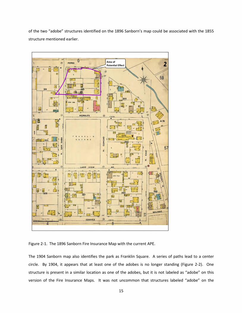
of the two “adobe” structures identified on the 1896 Sanborn’s map could be associated with the 1855
structure mentioned earlier.
Figure 2-1. The 1896 Sanborn Fire Insurance Map with the current APE.
The 1904 Sanborn map also identifies the park as Franklin Square. A series of paths lead to a center
circle. By 1904, it appears that at least one of the adobes is no longer standing (Figure 2-2). One
structure is present in a similar location as one of the adobes, but it is not labeled as “adobe” on this
version of the Fire Insurance Maps. It was not uncommon that structures labeled “adobe” on the
15
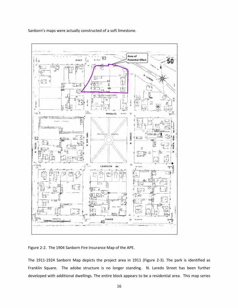
Sanborn’s maps were actually constructed of a soft limestone.
Figure 2-2. The 1904 Sanborn Fire Insurance Map of the APE.
The 1911-1924 Sanborn Map depicts the project area in 1911 (Figure 2-3). The park is identified as
Franklin Square. The adobe structure is no longer standing. N. Laredo Street has been further
developed with additional dwellings. The entire block appears to be a residential area. This map series
16

was drawn prior to the construction of the Church and Italian Hall. At this time, a large structure and a
few smaller dwellings were present on the property.
Figure 2-3. The 1911-1924 Sanborn Fire Insurance Map depicting the APE.
In the next Sanborn Fire Insurance Map, the Church and Hall had been constructed (Figure 2-4). The
1911-1950 Sanborn Fire Insurance Map depicts the Church and the Hall surrounded by a residential
neighborhood. Dwellings are present to the north and west of the Church. In addition, the park is still
17

called Franklin Square. A portion of North Concho was renamed North Columbus.
Figure 2-4. The 1911-1950 Sanborn Fire Insurance Map with the APE.
By March of 1963, the Rosa Verde Urban Renewal project was in the planning stage (Figure 2-5). The
City of San Antonio approved and passed Ordinance 31193, allowing the City of San Antonio to petition
for an advance in Federal funds (SAMA 2015b). In 1967, a portion of Columbus Park was deeded to the
18

Renewal Agency. The Society realized that portions of San Saba and Morales Street were to be closed
impeding the flow of traffic to the Church and Hall. In addition to traffic concerns, the Society felt that
the project would impact the available parking in the area. The City motioned to study the matters
further (CCMM Feb. 25, 1971). As part of the solution, the Urban Renewal Agency deeded to the Society
a parcel of land that could be used for additional parking (CCMM Feb. 25, 1971). In preparation for the
development of the area and construction of IH-35, all the structures that had been located in Block 325
other than the Church and the Hall were razed.
Figure 2-5. Plat with the APE showing the block behind the Church to be used for IH-35.
An aerial photograph taken in March of 1968 on file at the Institute of Texan Cultures shows that IH-10
had a loop for the interchange that occupied the property west of the Church. This would indicate that
there had been much disturbance to the open field and the location of the parking lot to the west. The
interchange construction resulted in the grading of the property, and movement of the soils to
19

accommodate the interchange, as well as the introduction of base material for the ramp. Once the
ramp was removed, the property would have undergone additional grading. It is possible that much of
the colonial surface would have been removed from the property during the construction and removal
of the interchange.
Previous Archaeology
The previous archaeology for the project area has been discussed in Nichols (2015), and this section
provides a recap of that work. The project area was surveyed in 1979 by UTSA-CAR for the Army Corps
of Engineers, Fort Worth Division. No archaeological sites were recorded in the vicinity of the Church or
Hall. Three sites were recorded in the general vicinity of the APE located approximately 0.32 to 0.60 km
from the project area: 41BX508, 41BX514, and 41BX992. Site 41BX508 is located approximately 0.3 km
to the southeast of the current project area. The site, the Menger Soap Works, was recorded by Anne
Fox of UTSA-CAR. The Soap Works was in operation during the mid-19th Century to the mid-20th
Century. The structure had fallen into ruins and was later converted into a clubhouse for an apartment
complex (THC 2015).
Located approximately 0.6 km to the northwest of the current APE is site 41BX514, the Ximenes Chapel.
The chapel is also known as the Chapel of the Miracles and is listed on the National Register of Historic
Places. The Chapel was likely constructed during the 1850s or 1860s by Juan Ximenes who was a soldier
in the Texas Army, once having fought in the Storming of Bexar. The chapel has been altered, but
retains its historical significance. Within the chapel is a crucifix that is reported to have been removed
from Mission San Antonio de Valero. It is possible that the crucifix was entrusted to the Ximenes family
once the mission was secularized. The chapel stands on private property but is open to the public (THC
2015). Chabot believed that this location was the first site of the mission (Chabot 1937).
Site 41BX992 (Milam Square or Milam Park) is located approximately 0.6 km to the south of the current
project area. The area was used as a cemetery until 1885. Some documentation indicates that the
burials were removed to the City Cemetery after 1885, although the archives are scant with information
(Tennis 1995). Subsequently, the property was used as a City Park. In 1993, the Center for
Archaeological Research removed a burial that was believed to be that of Ben Milam (THC 2015).
In addition to the archaeological survey that was conducted in 1979, the project area falls within the
boundaries of a neighborhood survey conducted in 1981. Several residential structures were recorded
20

along Kingsbury Street located east of the APE. Immediately to the east of the project area are the
Towne Center Apartments which were recorded during the 1981 survey as well. The NRHP eligibility of
the apartments was not listed (THC 2015).
From December 2012 to March of 2013, the UTSA-CAR was contracted by the San Antonio River
Authority and conducted a historic standing structure survey along San Pedro Creek. A portion of San
Pedro Creek that was part of the standing structure survey was located to the north of the current APE,
and the northern most portion of the APE was identified as property that was considered potentially
eligible for listing on the National Register of Historic Places (NRHP), mainly due to the potential for the
area to be the first location of Mission San Antonio de Bexar. In addition, the apartment complex
located to the east of the San Francesco di Paola Catholic Church was found to be not eligible for listing
to the NRHP (Tomka et al 2013).
In May of 2013, the UTSA-CAR conducted an archaeological investigation at Columbus Park and the
property owned by the Christopher Columbus Italian Society (Nichols 2014). A total of 31 shovel tests
and three test units were excavated during the course of the project. Surface collection within the APE
owned by the Christopher Columbus Italian Society produced a few small fragments of artifacts that
could potentially date to the Spanish Colonial Period of San Antonio. These included a forged nail, a
majolica sherd, olive glass, a trade bead, and a lead fragment. Test Unit excavations produced a few
small fragments of majolica and lead-glazed ceramics that could potentially date to the Spanish Colonial
Period. The majority of the cultural material recovered during the investigation consisted of artifacts
that dated to the nineteenth to twentieth century. The investigation concluded that it was possible that
the Spanish Colonial material had been re-deposited during the construction of the Church and Hall in
1927. UTSA-CAR recommended that additional archaeological investigations be conducted to
determine if evidence was present that could definitively identify the APE as the first location of Mission
San Antonio de Valero (Nichols 2014).
21

Chapter 3: Review of Historic Aerials
The historic aerials of the project area were examined to gather information concerning the more recent
impacts to the APE. The earliest aerial obtained for the area was taken in 1938 (Figured 3-1). The
Christopher Columbus Italian Society Hall and San Francesco di Paola Catholic Church had already been
constructed. However, the 1938 aerial is not clear enough to see each of the structures individually.
Nonetheless, it is evident that the area immediately south of San Pedro Creek is heavily developed.
Figure 3-1. The 1938 aerial of the project area.
22

The 1963 aerial is slightly clearer and depicts the Church, Hall, and neighborhood (Figure 3-2). Several
buildings occupy the area that is now an open field. It appears there was a structure located in the area
that currently has artifacts eroding on the surface. The aerial was taken before the Urban Renewal
Project was implemented.
Figure 3-2. The 1963 aerial of the APE showing houses located north of the Church and Hall.
23

By 1966, the neighborhood located north of the Church had been razed (Figure 3-3). In addition, a
highway interchange associated with IH-35 takes up the majority of the space where the community
once stood. A portion of the area located to the north of the Church and Hall has also been converted
into a parking lot.
Figure 3-3. The 1966 aerial of the project area showing the highway interchange loop.
The 1977 aerial shows that the parking lot to the north of the Church and Hall was increased in size
24

(Figure 3-4). The parking lot was extended to what is now N. Santa Rosa Street. It is likely that the
retaining wall that is seen from the street-level at the downslope edge of the parking lot was
constructed at this time. In addition, it appears that Columbus Park has undergone some renovations to
include a basketball court, parking, picnic areas, restrooms, and a pavilion with water feature.
Figure 3-4. The 1977 aerial showing the expanded parking lot.
The 1985 aerial shows little change to the area (Figure 3-5), although the park exhibits some additional
tree cover. The parking lot and interchange noted on the 1977 aerial are the same.
25

Figure 3-5. The 1985 aerial of the APE.
Between 1985 and 1995 the highway interchange was demolished (Figure 3-6). A portion of San Saba
Street was extended to meet N. Santa Rosa Street. San Saba Street now is the western boundary of the
26

APE. No other major changes to the landscape are visible.
Figure 3-6. The 1995 aerial of the APE showing extended San Saba Street.
By 2008, the upper parking lot, located outside of the APE and to the west of the Church, was
constructed. The remainder of the area appears to have stayed the same (Figure 3-7).
27

Figure 3-7. The 2008 aerial of the APE.
The 2014 aerial shows that there had been no major changes to the APE and its vicinity between 2008
and present (Figure 3-8).
28

Figure 3-8. The most current aerial of the project area.
The historic map and aerial review shows that the current APE has had several major changes over the
past century and a half. The majority of the neighborhood that once occupied the area north and
29

northwest of the church and hall was razed by 1966 to make way for the construction of an interchange
for IH-10. The 1966 aerial paired with aerial photographs on file at the Institute of Texan Cultures
indicated that a few houses at the far north of the property remained for a few additional years and a
parking lot had been constructed north of the hall. By 1977 those residences were gone and the parking
lot extended north to the access road. Additional disturbance to the APE occurred during the early
1990s as the interchange for IH-10 was demolished. It is possible that all of the construction activity in
the APE impacted a possible colonial surface that would contain indications that the site was used as the
first location of Mission San Antonio de Valero.
30

Chapter 4: Field and Laboratory Methodology
During the 2013 UTSA-CAR excavations, representatives of the Christopher Columbus Italian Society
mentioned to the archaeological crews that the grassy field to the west of the asphalted parking lot was
the borrow area from which dirt was taken to raise and level the surface of the parking lot prior to its
paving. Because it was assumed that archaeological deposits associated with the mission site would
have been present in this field, it was also anticipated that these materials would have been re-
deposited under the parking lot, but in a disturbed context. It was also hoped that the original ground
surface found under the parking lot fill may reveal cultural materials associated with the mission
occupation. Since one of the goals of the current project was to determine whether artifacts associated
with the first site of the mission were present at the location, the asphalted parking lot and the fill
underneath it, as well as the original ground surface buried by the fill became primary targets for
investigations. In addition, to substantiate the assertion that the soils from under the parking lot came
from the grassy field, limited investigations of the field also were planned. Finally, barring the discovery
of mission-associated artifacts under the parking lot, it was hoped that limited explorations near the top
of the landform may lead to the discovery of 18th century materials that could unequivocally be
associated with the 1718 mission.
To accomplish these investigations, three excavation methods were used across Society-owned portions
of the property: auger bores; shovel tests; and hand-excavated test units. First, mechanical auger bores
were used to examine the soil stratigraphy and cultural materials present under the parking lot. Auger
bores, in combination with hand-excavated shovel tests also were employed in the grassy field to
explore the stratigraphy and obtain a more representative sample of archaeological materials. Hand-
excavated 1x1 and .5 x.5 meter test units were used to examine limited portions of the top of the
landform and a high density cluster of materials identified in the grassy field.
Auger Boring
Auger boring was conducted within the parking lot and grassy field using a 24-inch diameter drill bit
attached to a M-Series Bobcat Skid Steer (under 3,000 lbs). The auger bit was 24-inches in diameter and
reached approximately 4-feet below the surface. A three-foot extension also was used to allow boring
to a maximum depth of 7 feet below the surface. Initially, it was proposed that auger bores would be
excavated in two-foot increments. However, the sticky clay that was present in many of the bore holes
31

made it difficult to determine the exact provenience of the soils adhering to the drill bit as it was
extracted from the bore hole. As a result, attempts to excavate in 2-foot increments were abandoned
following the initial three auger bores. Similarly, the soil removed from the first three auger bores was
screened through ¼-inch hardware cloth. It became evident, however, that the yellow clay zone was
sterile. Therefore, as augering continued, it was decided that once the yellow clay zone was reached,
the matrix was not to be screened unless a distinct zone of deposits appeared below it. It was hoped
that this distinctive zone would be the original ground surface buried by the fill.
All artifacts recovered from augers were collected in bags labeled with provenience information for
laboratory processing, analysis, and curation. A form was completed for each auger bore. Data
collected on these forms included the final excavation depth, a tally of all materials recovered from
screening, and a brief soil description (texture, consistence, Munsell color, inclusions). The location of
every auger boring was recorded with a Magellan Global Positioning System unit. Any additional
observations considered pertinent were included as comments on the standard auger excavation form.
Shovel Testing
RKEI excavated shovel tests within the grassy-field owned by the Christopher Columbus Italian Society.
All shovel tests were 30 cm in diameter and most were excavated to a depth of 60 cmbs. The shallow
depth of the shovel tests was chosen because during the excavation of deeper units, the technician will
typically scrape the sides of the unit as he/she removes the dirt from the bottom of the unit. During this
process, artifacts can de dislodged from any part of the wall providing incorrect information on artifact
provenience. Shovel tests were excavated in 10-cm increments and screened through ¼-inch hardware
cloth. All artifacts recovered from shovel tests were collected in bags labeled with provenience
information for laboratory processing, analysis, and curation. A form was completed for every excavated
shovel test. Data collected on these forms included the final excavation depth, a tally of all materials
recovered from each 10-cm level, and a brief soil description (texture, consistence, Munsell color,
inclusions). The location of every shovel test was recorded with a Magellan GPS unit. Any additional
observations considered pertinent were included as comments on the standard shovel test excavation
form.
Test Unit Excavation
RKEI excavated test units within the grassy field and in the courtyard between the Church and the Hall.
32

The units were excavated in arbitrary 10-cm increments. All matrix was screened through ¼-inch
hardware cloth and all artifacts recovered from each level were bagged with the appropriate
provenience information and returned to the RKEI Archaeology Laboratory for processing and analysis.
Soil samples, measuring approximately 1-gallon each, were collected from each excavation level and
returned to the laboratory where they were either dry-screened through window-screen mesh or water
screened. Level forms were completed for each excavation level. Information related to the broad
range of artifact types recovered, artifact quantities, and soil types were noted on the excavation forms.
Metal Detecting
Metal detecting occurred during one day of the field project. City Archaeologist, Kay Hindes, invited
Larion Crumley and Bill Telford, two local metal detectors, to scan the open field located to the west of
the Christopher Columbus Italian Society parking lot. The men swept the open field with their metal
detectors, investigating areas that registered as a metal object. Subsequently, the volunteers inspected
the anomalies by excavating small pits to expose the item that was indicated by the metal detector. Kay
Hindes monitored the metal detectors’ progress and examined the finds made during the day.
Laboratory Methods
Artifacts were processed in the RKEI Archaeology Laboratory where they were washed, air dried, and
stored in archival-quality bags. Acid-free labels were placed in all artifact bags. Each label displayed
provenience information and a corresponding lot number written in pencil. Additionally, the materials
were processed in accordance with current Council of Texas Archaeologists guidelines. Artifacts will be
returned to the property owners at the completion of the project.
Field notes, field forms, photographs, and field drawings were placed into labeled archival folders and
converted into electronic material. Digital photographs were printed on acid-free paper, labeled with
archivally appropriate materials, and placed in archival-quality plastic sleeves. All field forms were
completed with pencil. Ink-jet produced maps and illustrations were placed in archival quality plastic
page protectors to prevent against accidental smearing due to moisture. A copy of the report and all
digital material were burned onto a CD and permanently curated with field notes and documents. All
project related documentation is housed at the RKEI Archaeological Laboratory. At the completion of
the project, all material collected from the investigations were returned to the Christopher Columbus
Italian Society. A digital copy of all records is retained at the RKEI Archaeology Laboratory.
33

Chapter 5: Results of Archaeological Investigations
Auger Boring
A total of 18 auger bores was excavated during the course of the project (Figure 5-1). It was originally
assumed, based on topographic layout that the original surface may have been buried roughly 3-3.5 feet
below the parking lot. Therefore, a 4-foot auger bit was employed in the excavation of the first three
units. Given that yellow clay fill was encountered in these units, it was assumed that the excavations
had not penetrated through the fill into the top of the original ground surface. Therefore, a three-foot
bit extension was secured and employed in the excavation of all subsequent bore holes.
Figure 5-1. Location of Auger Bores, Shovel Tests, and Test Units.
34

Of the eighteen auger bores excavated, fourteen were positive for cultural material. The soil colors
encountered in the auger bores is presented in Table 5-1.
Units Excavated in the Parking Lot
All of the augers located within the parking lot (A-1 through A-3, and A-12 through A-17) (Figure 5-1)
were excavated through asphalt. The thickness of the asphalt varied across the parking lot (4-10 cm).
Table 5-1. Munsell colors of the soils encountered in the auger bores.Auger Bore
Level (cmbs) ColorAuger Bore
Level (cmbs) Color
1 1 (0-40) 10YR2/2 10 1 (0-40) 10YR3/1
1 2 (40-80) 10YR6/6 10 2 (40-80) 10YR6/6
1 3 (80-120) 10YR6/6 10 3 (80-120) 10YR6/6
2 1 (0-40) 10YR5/3 11 1 (0-40)10YR3/1
w/10YR8/2 2 (40-80) 10YR5/3 11 2 (40-80) 2.5Y6/4
2 3 (80-110) 10YR5/3 11 3 (80-120) 2.5Y6/4
3 1 (0-40) 10YR5/3 12 1 (0-40) 2.5Y5/4
3 2 (40-80) 10YR5/3 12 2 (40-80)2.5Y5/4
w/10YR6/
3 3 (80-120) 10YR5/3 12 3 (80-170)2.5Y5/4 -10YR8/1
4 1 (0-17) 10YR2/2 13 1 (0-40) 10YR2/1
4 2 (17-25) 10YR4/2 13 2 (40-80) 10YR2/1
4 3 (25-38) 10YR5/6 13 3 (80-90) 10YR2/1
4 4 (38-62) 10YR5/6 14 1 (4-24) 7.5YR5/6
4 5 (62-90) 10YR5/6 14 2 (24-156) 10YR3/1
5 1 (0-40)10YR2/2-10YR5/6
15 1 (0-40)10YR6/6 w/10Yr3/
5 2 (40-80) 10YR5/6 15 2 (40-80) 10YR6/6
5 3 (80-120) 10YR6/6 15 3 (80-200) 10YR6/6
6 1 (0-40)10YR3/2-10YR5/3
16 1 (0-40) 2.5Y6/4
6 2 (40-80) 10YR5/3 16 2 (40-80) 2.5Y6/4
6 3 (80-120) 10YR6/6 16 3 (80-190) 2.5Y6/4
7 1 (0-40) 10YR2/2 17 1 (0-40) 10YR4/3
7 2 (40-80) 10YR5/4 17 2 (40-80)10YR4/3-10YR6/6
7 3 (80-120) 10YR5/4 17 3 (80-90) 10YR6/6
8 1 (0-40)10YR4/2 w/10YR8
18 1 (0-40)10YR2/2-10YR4/2
8 2 (40-80) 10YR5/4 18 2 (40-80) 2.5Y5/6
8 3 (80-120) 10YR6/3 18 3 (80-130) 2.5Y5/6
9 1 (0-40) 10YR3/1
9 2 (40-80) 10YR6/6
9 3 (80-120) 10YR6/4
35

Below the asphalt was a layer of base that ranged in thickness from 10 to 15 cm. The soils encountered
below the base varied across the lot.
Auger 1 (A-1) exhibited a dark clay loam (10YR2/2) below the layer of base material (Table 5-1). This
zone was approximately 20 cm thick (20-40 cmbs). Yellowish brown clay (10YR6/6) extended to the
bottom of the unit in the rest of the bore unit (120 cm below surface). Relatively few artifacts were
encountered within A-1 and those found came out of the dark clay loam zone. Materials encountered
consisted of concrete, glass, metal fragments, and a fragment of animal bone (Table 5-2).
Auger 2 (A-2) was excavated in the southern end of the parking lot (Figure 5-1). The upper 15 cm of A-2
consisted of asphalt and road base. The remainder of the unit exhibited disturbed soils. No cultural
material was encountered within A-2. Auger 2 was excavated to 110 cm below the surface.
Auger 3 (A-3), located in the northern portion of the parking lot (Figure 5-1), was excavated to a depth
of 120 cm below the surface. The upper 15 cm consisted of asphalt and road base. Below the asphalt
and base, the soils consisted of the yellowish brown clay throughout the unit. During the augering of
the first 40 cm, the bit encountered a large block of concrete (Figure 5-2). The auger bore was widened
to allow for continued excavation. The material noted within A-3 consisted of concrete fragments,
asphalt fragments, and one clear glass fragment (Table 5-2) that came out of the upper portion of the
unit. Once the auger bore was completed, it was noted that the concrete block that had been removed
was part of a much larger piece. The portion remaining in the auger bore was approximately 40x25 cm
in size. The top of the concrete was encountered approximately 30 cm below the surface and extended
to approximately 68 cm below the surface, indicating disturbance to at least this depth.
36

Figure 5-2. Concrete block encountered in Auger 3.
37

Auger 1 Auger 3 Auger 12 Auger 13 Auger 14Ct. Wt. (g) Ct. Wt. (g) Ct. Wt. (g) Ct. Wt. (g) Ct. Wt. (g)
Faunal Bone 1 0.7 5 4.8 50 160 56 165.5Colonial Ceramic
Green Lead Glazed 1Construction Material
Brick/Tile 1 0.6 9 146 15 56.8 25 203.4Asphalt 1 17.1 1 17.1Concrete 3 55.9 2 332 1 65.3 6 453.2Wood 1 3.5 1 3.5
European CeramicIronstone 22 22White Earthenware
Molded 1 1Undecorated 1 16 17
GlassChimney 3 3Container
Aqua 2 1 43 46Blue-Green 1 1Brown 3 23 26Clear 3 1 4 7 15Dark Olive 1 1Green 1 1 2Olive Green 1 1
Flat 3 18 21Lithic, Hammerstone 1 1
MetalFastener
Cut Nail 1 10 5 41.1 6 70.6Finishing Nail 1 1.1 1 1.1Tack 1 1.6 1 1.6Unidentified Nail 3 11 2 3 5 14Wire Nail 7 31.5 7 31.5
Cast Iron 2 88 2 88Scrap 1 0.7 3 3.9 4 4.6
Buckle 1 21 1 21Other Metal
Electrical Wire 1 0.6 1 0.6Hinge/Bracket 1 0.8 1 0.8Sheet Metal 1 0.4 1 0.4Strap 3 11.6 3 11.6Unidentified 1 37.7 1 37.7
Charcoal 1 0.2 1 2.1 1 0.8 3 3.1Other Rock
Chert 2 2Gypsum 1 1Limestone 4 2
PersonalSlate, Writing 1 1
Mussel Shell 1 0.3 1 0.3Plastic 1 1 2Toy
Marble, China glazed 1 1Porcelain, doll 1 1
Grand Total 13 57.8 6 349.1 1 10 58 417.2 219 276 294 1129.6
Tota
l Ct
.To
tal
Wt.
(g
)
Table 5-2. Artifacts collected during the augering of the asphalted parking lot.
38

Following the excavation of these three auger bores, it became apparent that the 4-foot bit used was
not reaching below the yellowish brown clay that was suspected to be fill brought in during the
construction of the parking lot. Because one of the goals of the investigations was to reach the original
ground surface upon which the fill was placed, a 3-foot bit extension was obtained. While the bit-
extender was procured, auger bores were excavated in the grassy field to the west of the parking lot to
determine if this area exhibited a similar stratigraphy and whether we could substantiate the
information that this area was used as a borrow pit for soils used as fill under the asphalted parking lot.
Excavations within the parking lot continued once the bit extension was obtained.
The excavation of Auger 12 (A-12) occurred in the Christopher Columbus Italian Society’s parking lot
(Figure 5-1) using the 7-foot extended auger bit. This allow for the auger bore to be excavated to a
terminal depth of 190 cm below surface. The upper 10 cm of A-12 consisted of asphalt and base. Below
the base, the soil was light olive brown (2.5Y5/4) clay to approximately 150 cm below the surface. The
remaining 40 cm consisted of white, silty sand (10YR8/10). The single artifact encountered in A-12 was a
cut nail (Table 5-2), it came out of the upper 20 cm of the deposit.
Auger 13 (A-13) was placed within the asphalted parking lot (Figure 5-1). The auger bore was
terminated at a depth of 90 cm below the surface after encountering an obstruction, a clay sewer pipe.
It appeared that the bore unit was positioned on the sewer installation trench. The upper 10 cm
consisted of asphalt and base. The remainder of A-13 exhibited black clay loam that contained a high
density of artifacts in comparison to the other auger bores excavated. Included in the artifact inventory
of A-13 were: wire nails, cut nails, finishing nails, brick, concrete, plastic, glass fragments in various
colors, undecorated white earthenware, mammal bone, saw cut mammal bone, mussel shell, metal
scrap, and a ceramic marble (Table 5-2).
Auger 14 (A-14) was excavated to a terminal depth of 190 cm below surface (Figure 5-1). The upper 24
cm consisted of asphalt and base. Between 24 and 190 cm below surface, the soil was a very dark gray
clay loam that contained some gravels (Figure 5-3). Auger 14 exhibited a high density of artifacts
throughout the dark gray clay loam. The artifact assemblage of A-14 included glass fragments of various
colors, metal fragments, nail fragments, flat and chimney glass, undecorated white earthenware
fragments, one green lead glazed ware, faunal bone, a porcelain doll head fragment, and a possible
hammerstone (Table 5-2).
39

Figure 5-3. Dark soil containing artifacts encountered in Auger 14.
Auger 15 (A-15) was excavated to a terminal depth of 2-meters below the surface (Figure 5-1). The
upper 18 cm consisted of asphalt and base. Just below the base, the soil changed to a yellow clay with
very dark grayish brown mottles. The clay was consistent throughout the remainder of A-15 and was
found to be sterile. Similar yellow clay deposits encountered in other auger bores contained no
cultural material. Due to the added quantity of soil extracted from deeper auger bores, and the lack of
cultural material seen in earlier excavated tests, it was decided to not screen the clay matrix in
subsequent auger bores.
The upper 16 cm of Auger 16 (A-16) consisted of asphalt and base. Auger 16 was excavated to a
terminal depth of 190 cm below the surface. Below the base, the matrix became yellowish-brown clay.
The texture was very similar to the soil encountered in A-15, although the clays in this unit were less
mottled and had a brighter yellow color. The light yellowish brown clay was uniform throughout the A-
40

16 (Figure 5-4). Examination of the clays brought up by the auger bit identified no cultural deposits in
the matrix. It appeared to be sterile as was the same deposit in A-15.
Figure 5-4. Clay fill noted in Auger 16.
The upper 15 cm of Auger 17 (A-17) consisted of asphalt and base. Beneath the base, between 15 and
65 cm below the surface, the matrix was brown clay with brownish yellow mottles. From 65 to 90 cm
below the surface, the soil consisted of brownish yellow silty clay. The soils in A-17 were similar to that
seen in A-15 and A-16. No cultural materials were noted in the matrix.
Units Excavated West of Parking Lot
Auger 4 (A-4) was excavated in the grassy field located to the west of the parking lot (Figure 5-1). The
unit was purposefully placed in one of the lowest spots in the field to determine what soil strata would
be noted immediately below the surface. The soil stratigraphy differed significantly from that seen
41

within the parking lot. The upper 17 cm below the surface exhibited dark brown, loamy clay. This
represented top soil that was deposited sometime after the construction of IH-35. Some gravels were
noted in the soil. Between 17 and 25 cm below the surface, the soil changed to dark grayish brown clay.
Again, gravels were noted in the matrix. Between 25 and 38 cm below the surface, the soil consisted of
yellowish brown clay with brown mottling. The soil then changed to dark yellowish brown silty clay that
extended to approximately 62 cm below the surface. Between 62 cm and 90 cm below the surface, the
soil contained higher proportions of clay content and an increase in gravel content. The cultural
material encountered in A-4 included glass fragments, brick and limestone fragments, a fragment of
porcelain, and a fragment of undecorated white earthenware came from the upper part of the unit
(Table 5-3). The artifacts came from the upper 38 centimeters of matrix.
Auger 5 (A-5) was located in the grassy field (Figure 5-1). A-5 was excavated to a terminal depth of 120
cm below the surface. The upper 10 cm of soils appears to have been disturbed. Beneath the disturbed
soils, the matrix become yellowish brown silty clay and continued to the base of the unit. The lower
portion of the auger contained gravels similar to A-4. Auger-5 produced one fragment of burned chert,
a piece of 7-Up green glass, two lead glazed sewer pipe fragments (Table 5-3), and one fragment of
sandstone. The artifacts appear to have been derived from nineteenth and early twentieth century
residences that once stood in the general vicinity of the project area.
The soils in Auger 6 (A-6) differed from that of A-5. The auger was excavated to a depth of 120 cm
below the surface. The upper 15 centimeters consisted of very dark grayish-brown loamy clay that
contained grass roots. The soil then changed to brownish silty clay which extended to the base of the
unit. The matrix in the bottom 5 cm of the unit consisted of yellow clay, similar to the sterile zone in a
number of other units. Auger 6 contained fragments of brick, mortar, limestone, and plastic. In
addition, ceramic fragments also were recovered. These included undecorated ironstone, undecorated
white earthenware, hand-painted white earthenware, and a fragment of a lead glazed olive jar (Table 5-
3). The artifacts were present throughout the brownish silty clay that comprised most of the unit.
The upper 20 cm of Auger 7 (A-7) consisted of very dark brown silty clay. The soil changed to yellowish
brown silty clay for the remainder of the auger bore. Auger 7 produced cultural material including glass
fragments, a wire nail, asphalt, mortar, limestone, and a fragment of molded white earthenware (Table
5-3). It was excavated to a terminal depth of 120 cmbs. The material appears to be derived from the
nineteenth and early twentieth century residences and came from the yellowish brown silty clay zone.
42

Auger 8 was excavated to a terminal depth of 120 cm below the surface. The upper 40 cm of A-8
consisted of dark grayish brown silty clay that contained the majority of the cultural material. A layer of
hard-packed lime caliche was present between 20 and 30 cm below the surface. Below the dark grayish
brown soil, the matrix changed to yellowish brown clay. The last 40 cm of the auger consisted of pale
brown clay with a slight silt content. The artifacts recovered from the auger included glass fragments,
brick, cement, mortar, linoleum, Flow Blue ceramic with gilding, and two fragments of tin-glazed
ceramics (Table 5-3). One of the tin-glazed wares was undecorated, the other exhibited a maker’s mark
with a small, stamped “E”. The mark is not typically seen on Spanish Colonial majolicas associated with
the colonial occupation of San Antonio.
43

Auger 4 Auger 5 Auger 6 Auger 7 Auger 8 Auger 9 Auger 10 Auger 11 Auger 18Ct. Wt. (g) Ct. Wt. (g) Ct. Wt. (g) Ct. Wt. (g) Ct. Wt. (g) Ct. Wt. (g) Ct. Wt. (g) Ct. Wt. (g) Ct. Wt. (g)
ArmsCartridge Casing 1 1
Possible Gunflint 1 1Faunal Bone 1 1.6 1 28.5 1 1.9 15 48 18 80Burned Rock 1 1.1 1 23.6 2 8.7 4 33.4Colonial Ceramic
Lead GlazedGreen Lead Glazed 1 1Olive Jar 1 1Undecorated 1 1
Tin-GlazedUndecorated 1 1
Construction MaterialBrick/Tile 2 7.2 2 12.6 3 1.6 2 3.1 1 174 10 198.5
Asphalt 4 5.2 4 5.2Cement 1 174 1 15 1 4.6 3 193.6Limestone 3 1792 3 1792Mortar 1 4.7 1 4.7Wood 1 2.7 1 2.7
European CeramicIronstone 1 1Porcelain 1 1 2Stoneware, Albany 1 1White Earthenware
Cut Sponge 1 1Gilded Flow Blue 2 2Handpainted 1 1Molded 1 1Undecorated 1 1 1 6 9
GlassChimney 1 1 2Container
7-Up Green 1 1 2Aqua 1 1 1 12 15Blue-Green 1 1Brown 1 5 5 1 1 13Clear 2 4 10 4 3 6 29Light Green 1 1Light Green Milk 1 1Milk 2 1 3Olive Green 1 1 2
Flat 2 2 1 7 2 1 15 Mirror 1 1Lithic Debitage 1 1 2Metal
FastenerCut Nail 2 8.2 8 19.5 10 27.7Finishing Nail 1 1.1 1 1.1Unidentified Nail 4 3.1 5 10.4 9 13.5Wire Nail 1 3.8 3 2.7 4 6.5
Scrap 6 8.6 2 13.8 8 22.4Unidentified, Lead 1 12.9 1 12.9
Can 4 108 4 108Charcoal 1 0.01 1 1.4 2 1.41Other Ceramic
Sewer Pipe 2 2Other Rock
Limestone 5 356 1 2 2 43.3 10 399.3Sandstone 1 63.3 1 17.1 2 80.4
PersonalButton, Loop Shank 1 1.4 1 1.4Slate, Writing 3 3
Mussel Shell 1 0.2 1 0.2Synthetic
Insulated Wire 1 1Wrapper 1 1Linoleum 1 1
Grand Total 16 363.2 5 64.4 12 187 20 25.6 56 1827 21 112.3 2 28.5 11 212.4 75 164.9 216 2984.91
Tota
l Ct
.
Tota
l W
t.
(g)
Table 5-3. Artifacts recovered from the augers excavated in grassy area.
44

Auger 9 (A-9) was excavated to a terminal depth of 120 cmbs. The upper 40 cm consisted of very dark
grey clay loam. Brownish yellow clay appeared below that and was sterile. The last 30 cm of the auger
bore exhibited light yellowish brown silty clay that contained limestone gravels. This layer did not
produce any cultural material. The artifacts encountered were located in the upper dark grey clay loam.
Materials collected included glass fragments, saw cut bone, metal, and a fragment of undecorated white
earthenware (Table 5-3).
Auger 10 (A-10) was excavated to a terminal depth of 120 cmbs. The upper 40 cm of the matrix
encountered in the unit consisted of very dark gray clay and clay loam. There was some mottling within
the layer that also included approximately 15% gravels. The remainder of the auger consisted of
brownish yellow clay that had few inclusions. The last 20 cm exhibited some mottling and a few gravels.
Artifacts, although very few, were recovered from the upper 40 cm of the dark gray clay and clay loam.
The artifact sample from A-10 consisted of saw cut bone and a fragment of brown glass.
Auger 11 (A-11) was excavated to a terminal depth of 120 cm below surface (Figure 5-1). The upper 10
cm consisted of a very dark gray clay loam (Figure 5-5). Between 10 and 15 cm below the surface, there
was a hard-packed limestone caliche layer. From 15 to 40 cm below the surface, the soil consisted of
very dark grayish brown silty clay. The remainder of the auger exhibited light yellowish brown silty clay
(2.5Y6/4). Only a small number of artifacts were recovered from A-11. These included burned rock, a
sandstone brick, plastic, and an unidentified lead fragment (Table 5-3).
45

Figure 5-5. Profile of Auger 11.
Auger 18 (A-18) was placed near the southeast corner of the grassy field. There was a pile of soil located
near the unit (Figure 5-1). Just north of the auger were the units that were excavated by UTSA-CAR in
2013. There appeared to be more artifacts exposed through erosion since the previous field
investigation. The auger bore was excavated to ascertain if there was a shallowly buried cultural deposit
near the upper edge of the landform from which the artifacts were originating. Auger 18 was excavated
to a terminal depth of 130 cm below the surface. The upper 10 cm consisted of very dark brown, silty
clay. Between 10 and 40 cm below the surface, the matrix was dark grayish brown silty clay. Both of
these upper layers appeared to consist of relatively loose soils. From 40 cm to the terminal depth, the
soil encountered was light olive-brown, compact, clay. Within this stratum, medium-sized gravels were
noted. Cultural material collected included glass fragments, cut nails, wire nails, finishing nails, saw cut
bone, metal fragments, one fragment of lead-glazed ceramic that appears to be from a molcajete,
undecorated white earthenware, and a fragment of cut-sponge decorated ceramic (Table 5-3). The
46

artifacts were derived from the upper 40 cm of the unit. In general, the bulk of the artifacts recovered
from the auger bores consist of nineteenth to twentieth century items. The only exceptions are the
possible fragmentary hammerstone and the lead glazed ceramic fragment.
Shovel Tests
Four shovel tests were excavated during the course of the project. Three of the shovel tests (STs 1-3)
were placed along the southern edge of the grassy field, near the chain-link fence and newer parking lot
(Figure 5-1). The area was as close to the apex of the landform as feasible within property owned by the
Christopher Columbus Italian Society. The fourth shovel test (ST 4) was placed along the eastern edge of
the grassy field (Figure 5-1), near the boundary of the asphalted parking lot.
The upper 20 cm of Shovel Test 1 soil consisted of very dark brown clay that contained pea-sized gravels
(Figure 5-1). No cultural material was encountered within the first 20 cm of matrix. In Level 3 (20-30
cmbs), one fragment of natural sandstone was encountered. Level 4 (30-40 cmbs) consisted of light
olive brown mottled clay. Artifacts recovered from this level included brown and clear glass fragments,
and one fragment of animal bone (Table 5-4). Level 5 (40-50 cmbs) continued with the mottled clay.
Three fragments of red brick and a scrap of metal were recovered from this level. Soil color changed to
light olive brown and retained no mottling in Level 6 (50-60 cmbs). It continued to the terminal depth of
the shovel test, at 65 cm below the surface. No cultural material was encountered within the last two
levels of ST 1.
Shovel Test 2 exhibited very dark brown clay to a depth of 60 cm below the surface. In Level 7 (60-70
cmbs), the soil changed to mottled light olive brown clay loam. Between 70 and 82 cm below the
surface, the same soils were noted as in the higher levels. Level 1 (0-10 cmbs) did not contain cultural
material. Level 2 (10-20 cmbs) produced asphalt, brick, and a fragment of scrap metal (Table 5-4). Level
4 (30-40 cmbs) contained brick, mortar, a glass fragment, faunal remains, and ferrous metal. Level 5
(40-50 cmbs) produced a ferrous scrap metal, a fragment of clear glass, and asphalt. One small
fragment of debitage was recovered in Level 6 (50-60 cmbs).
47

Shovel Test 3 was excavated to a depth of 72 cm below surface. The soil consisted of very dark brown
clay in the upper 60 cm, with limestone cobbles. Between 60 and 72 cm below the surface, the soil was
light olive brown silty clay. One fragment of aqua glass was recovered in Level 3 (20-30 cmbs) (Table 5-
4). Level 4 (30-40 cmbs) produced a brick fragment and a fragment of debitage. Level 5 (40-50 cmbs)
also contained a brick fragment, as well as an unidentified nail. Level 7 (60-72 cmbs) contained an
unidentified nail, a brown glass fragment, and a fragment of asphalt.
Shovel Test 4 was excavated to a terminal depth of 75 cm below surface, although only the first three
levels produced artifacts. The first three levels (0-30 cmbs) consisted of very dark grayish brown silty
clay. Between 30 and 75 cm below the surface, the soil was dark greyish brown (2.5Y4/2) silty clay.
Level 1 (0-10 cmbs) produced asphalt fragments, brown and aqua glass fragments, animal bone, and an
unidentified nail fragment. Level 2 (10-20 cmbs) contained only a fragment of mussel shell and aqua
glass fragments. Level 3 (20-30 cmbs) had the highest density of artifacts with saw cut and uncut
mammal bone, brown and clear glass fragments, a cut nail, plastic, mortar, and a fragment of
Transferprint white earthenware (Table 5-4).
Test Units
Three test units were excavated during the project. Two were 50 cm-x-50 cm units placed within the
courtyard between the San Francesco di Paola Catholic Church and the Christopher Columbus Italian
Society building (Figure 5-1). The third unit (1 m-x-1 m) was located within the southeastern portion of
the grassy field (Figure 5-1), between the location of A18 and the units excavated in 2013 by UTSA-CAR.
Table 5-4. Artifacts recovered from shovel testing. European Ceramic Lithic Syntheti
Ct Wt (g) Brick/TileWhite Earthenware Debitage Plastic
Transfer Aqua Brown ClearCt Wt (g) Ct Wt (g) Ct Wt (g) Ct Ct Ct Ct Ct Ct Wt (g) Ct Wt (g) Ct Wt (g) Ct Wt (g) Ct
ST-130-40 1 0.2 1 1 3 0.240-50 3 6.2 1 0.5 4 6.7
ST-2 10-20 1 0.6 1 0.7 1 0.5 3 1.830-40 1 1.3 2 0.7 1 0.5 1 1 4.9 3 2.6 9 1040-50 1 30.6 1 1 3.4 3 3450-60 1 1
ST-320-30 1 130-40 1 0.9 1 0.940-50 1 33 1 2.5 2 35.560-72 3 115 1 1 5.8 5 120.8
ST-4 10-20 2 1 0.01 3 0.010-10 1 0.5 1 26.6 1 12 1 2.1 16 29.220-30 4 15.2 1 1.9 1 1 2 1 2.2 2 12 19.3
Grand Total 7 17.2 8 41.4 6 173 2 2.4 1 4 15 5 1 1 2.2 4 15.3 6 7 1 0.01 2 63 258.41
Bone
Container Fastener
Cut Nail Unidentified Nail
Glass
Tota
l Wt
(g)
Mussel Shell
Asphalt Mortar
Construction Material Metal Shell
Scrap
Tota
l Ct
48

Test Unit 1 was a 50-x-50 cm unit placed near the center of the courtyard. The brick pavers, sand, and
base material comprised the upper 25 cm of matrix that was removed prior to excavating the unit. A
rotary hammer drill with spade attachment was utilized to remove the upper layer of asphalt and base
before unit excavations started. The datum was set at the level of the top of the brick pavers, the actual
courtyard surface. The unit was excavated to 40 cm below the datum, and then backfilled. Level 1 (15-
20 cmbs) contained sticky clays that contained base and asphalt fragments, and was hard to screen. The
artifacts collected from Level 1 (15-20 cmbs) included concrete fragments, asbestos, brick, a heat spall,
an unidentified nail, and a fragment of undecorated white earthenware (Table 5-5). Level 2 (20-30
cmbs) also exhibited the same sticky clay. Artifacts encountered animal bone, brick, asbestos, possible
cut nails, limestone fragments, sandstone fragments, and debitage.
Test Unit 2 was placed to the northeast of Test Unit 1 near the ramp leading into a side door of the
Christopher Columbus Italian Society. The unit measured 50-x-50 cm. The brick pavers were removed
prior to excavation of the unit. Beneath the pavers was a layer of sand. The sand was removed and
reserved for reuse. Below the sand was asphalt and base. The RKEI archaeologists utilized a rotary
hammer drill with a spade attachment to break through the asphalt and base layer. The datum was set
at the top of the brick pavers. Approximately 36 cm of pavers, sand and base was removed prior to the
hand-excavation. Level 1 (26-30 cmbs) encountered dark greyish brown soils that were similar to the
clay noted in the parking lot during augering. Asphalt fragments were noted in the soil. Artifacts
collected from the level included mortar, glass fragments, sandstone brick, and an unidentified nail
(Table 5-6). Level 2 (30-40 cmbs) consisted of the same disturbed soils noted in Level 1. Asphalt
fragments were present in the moist clay. The artifacts collected from the level included brick, concrete,
amethyst glass, and an unidentified nail fragment. Level 3 (40-50 cmbs) also exhibited disturbed soils
with asphalt mixed into the matrix. The soil continued to be sticky, moist clay. At approximately 45 cm
below surface, the top of a gas main was exposed running north/south in the unit. The remainder of the
level was excavated to 60 cm below surface. Artifacts recovered from the disturbed soils included brick,
Table 5-5. Artifacts recovered during the excavation of TU-1.European Ceramic Organics
AsbestosWhite Earthenware Debitage Heat Spall
UndecoratedCt Wt (g) Ct Wt (g) Ct Ct Wt (g) Ct Ct Ct Ct Wt (g) Ct Wt (g) Ct Wt (g)
TU-1Lvl 1 (25-30) 1 1.7 1 1 9 1 1 2 7.9 7 18.6Lvl 2 (30-40) 2 1.7 12 10.5 1 2 1 1 20.6 4 38.6 2.1 23 73.5
Grand Total 2 1.7 13 12.2 2 1 9 1 2 2 1 20.6 6 46.5 2.1 30 92.1
Bone
Faunal Brick/Tile
Construction Material
Cement
Tota
l Wt
(g)
Tota
l Ct
Lithic Metal
Fastener
Bracket Unidentified Nail
Charcoal
49

mortar, asphalt, metal fragments, coal, undecorated white earthenware, and a fragment of semi-
porcelain (Table 5-6). Test Unit 2 was terminated at the base of Level 3 due to a gas pipe.
Test Unit 3 was located within the grassy field, north of Auger 18, and south of the test units excavated
by UTSA-CAR in 2013. Level 1 (2-10 cmbs) encountered a very dark grayish brown silty clay. The soil
was fairly loose, and contained grass roots. A total of 36 artifacts and 399.8 g of cultural material were
recovered from Level 1 (Table 5-7). Artifacts in Level 1 consisted of a mix of modern debris and some
late-nineteenth to mid-twentieth century materials.
Level 2 (10-20 cmbs) encountered a dark brown silty clay, that transitioned into a light tan silty clay
reminiscent of caliche. The artifact density increased in comparison to Level 1 (2-10 cmbs). A total of
199 items and 1462.4 g of material were recovered from Level 2. The artifacts encountered appear to
be a mixture of modern and early-twentieth century items. Various colors of glass fragments were
collected, as well as both cut and wire nails (Table 5-7).
Table 5-6. Artifacts recovered from TU-2.
Bone LithicSemi-Porcelain
White Earthenware Chimney
Heat Spall Coal
Concrete Undecorated Undecorated ClearAmethyst (Purple) Aqua Clear Coal
Ct Wt (g) Ct Wt (g) Ct Wt (g) Ct Wt (g) Ct Ct Wt (g) Ct Ct Ct Ct Ct Ct Ct Ct Wt (g) Ct Wt (g) Ct Wt (g) CtTU-2
Fill 1 1Lvl 1 (35-40) 1 156 1 24.3 1 39.1 1 1 1 5.1 1 0.2 7 224.7Lvl 2 (40-50) 6 532 1 0.6 1 1 1 1.7 10 534.3Lvl 3 (50-60) 2 2 4 558 8 27.3 6 14.6 4 12.4 1 3 1 5 15.4 7 17.8 1 2.6 1 43 650.1
Grand Total 2 2 11 1246 9 27.9 7 38.9 1 5 51.5 1 3 1 1 1 1 1 7 22.2 7 17.8 2 2.8 1 61 1409.1
European Ceramic
Brick
Mammal
Faunal
Sandstone
Brick/Tile
Asphalt
Construction Material
Mortar Tota
l Ct
Tota
l Wt
(g)
OrganicsMetalGlass
Container Fastener
Unidentified Nail
Other
Scrap
Charcoal
50
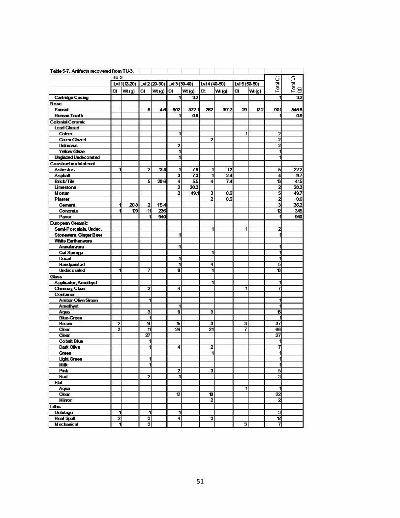
51

Level 3 (30-40 cmbd) exhibited a soil change and dramatic increase in the density of artifacts. The soil
became brown, silty clay with caliche inclusions. The artifact sample encountered in Level 3 (30-40
cmbd) was a mixture of mostly nineteenth- and twentieth-century material (Table 5-7). A few
fragments of ceramics collected could potentially date to the Spanish Colonial Period, although the
types are known span the entire period (1718-1790s) and into the nineteenth century. Animal bone
fragments comprised the largest portion of the artifact assemblage. One heavily worn human molar was
52

recovered during the excavation in Level 3. The presence of the tooth does not indicate a human burial.
Rather, the molar represents a natural loss and was an isolated encounter.
Level 4 (40-50 cmbd) exhibited similar soils as noted in Level 3 (30-40 cmbd). In the southwestern
corner of the unit, a pocket of sand was encountered. The pocket was circular, and extended into the
next level. The density of artifacts decreased in Level 4 (40-50 cmbd; Table 5-7). Animal bone
comprised the largest portion of the sample. Artifacts appear to date primarily to the nineteenth and
twentieth century.
Level 5 (50-60 cmbd) exhibited a dramatic decrease in the number of artifacts. The soil consisted of
dark brown silty clay. Artifacts included glass, metal objects, European ceramic, a small fragment of
Galera ware, and animal bone. The sample of artifacts continued to appear to be a mixture of
nineteenth to twentieth century items, with one ceramic sherd that could date to the Colonial period.
The excavation of the unit was terminated at the base of Level 5 (50-60 cmbd). The artifact density in
Level 5 decreased dramatically. In addition, the pocket of sand that had been encountered in the
previous level continued throughout Level 5, with an outline still present at the base of the level. The
pocket of sand is evidence of more recent disturbance.
Possible Spanish Colonial ceramics were present in each of the three deepest levels (Levels 3-5). Their
numbers mirrored the number of total artifacts in these levels, that is the highest numbers (n=5)
occurred in Level 5 decreasing thereafter with each level (n=2 in Level 4 and n=1 in Level 5).
Metal Detecting
All artifacts encountered during metal detecting were collected and returned to the RKEI Archaeology
Laboratory for processing and analysis. None of these artifacts are associated with the eighteenth
century. Table 5-8 lists these artifacts.
53

CountUndecorated White Earthenware 1
Glass
Container, Brown 1
Flat 1
Lithic, Core 1
Metal
Fastener
Bolt 4
5" 1
8" 2
Bracket
Ferrous 2
Lead 2
Cut Nail 5
Hinge 1
Spike 1
Unidentified Nail 4
Washer, Lead 1
Wire 3
Wire Nail 3
Awl/Leather Punch 1
Broad-head Axe 2
Knob
Cast Iron 1
Cuprous 1
Lead Cover Plate 1
Padlock, Cuprous 1
Pipe
Cast Iron 1
Cuprous 1
Ceramic Marble 1
Grand Total 40
Table 5-8. Artifacts recovered during metal detecting.
54

Chapter 6: Artifact Discussion
Ceramics
A moderate number (n=128) of ceramics was recovered during the investigations at the Christopher
Columbus Italian Society property. The collection of sherds has been divided into analytical categories
reflective of their manufacture location and temporal range. The following categories have been
identified: Native American, Spanish Colonial, and European.
Native American
The most common Native-made ceramic variety that has been recovered at Spanish Colonial Period sites
in San Antonio is Goliad wares. This type is common to this region. Goliad wares are hand coiled using
local clays and the addition of crushed and finely ground bone. The local (upper San Antonio River) clays
are typically devoid of sand or sand constitutes less than 5 percent of the fabric. The ceramic type is an
extension of the Toyah Phase ceramic technology. Two sherds of Goliad ware were recovered from the
surface in the field adjacent to the asphalted parking lot (Figure 6-1a). One is a thin walled specimen
with small and sparse specks of finely ground bone. The second specimen is a small fragment that
represents a well-formed base of a vessel and a small portion of the body (Figure 6-1b). The presence of
such a well-formed base and the fully oxidized core and reddish color of the piece suggests that the
vessel may have been kiln-fired. And, since it appears to be bone-tempered, the combination of these
two characteristics suggests that the potter employed the typical Goliad ware clay fabric to manufacture
a vessel form that imitated a Spanish Colonial vessel fired in a kiln rather than in an open-air bonfire.
Finally, the vessel may also have been made on a wheel rather than being manufactured using the more
traditional coil method employed within the native ceramic tradition.
55

a b
Figure 6-1. Goliad ceramics recovered from the surface (a) and close-up of base fragment (b); base at
left margin of image.
Spanish Colonial (n=19)
Spanish Colonial wares were made in the Spanish occupied areas in Mexico during the colonial period.
The most popular manufacture sites were in Puebla, Guanajuato, and Mexico City. These wares made
their way to San Antonio by mule train and are common finds at sites that were inhabited during the
mission period. The Spanish Colonial wares can be divided into three different glaze types: Lead Glazed,
Tin Glazed, and Unglazed.
Lead Glazed Wares
Thirteen lead glazed ceramic sherds were recovered during the course of the excavations within the
Christopher Columbus Italian Society property. Lead glazed sherds are typically associated with the
Spanish Colonial occupation of the area, although their dates of manufacture could extend into the mid-
to late-nineteenth century, depending on the type. Table 6-1 lists the potential colonial ceramics
recovered during the investigations.
56

Galera (n=2)
Galera is a fine-pasted earthenware type. Galera vessels are made using the mold technique rather than
the wheel, and are often thin-walled (Fox and Ulrich 2008). Typically, the vessel paste is orange, and is
visible through the thin, clear lead glaze. Decorations in cream, green, and brown are noted on the
exterior. Common decorative motifs include dots, feathers, and flowers (Fox and Ulrich 2008). Galera
wares were manufactured in Mexico, most likely in the state of Jalisco. Dates of manufactured are
believed to be between 1725 and 1850, although similar wares are made to this day in Mexico. Two
fragments of Galera ware were recovered from Test Unit 3 (Figure 6-1 b and c; Table 6-1). One was
collected from Level 3 (30-40 cmbd), and the other was in Level 5 (50-60 cmbd).
Olive Jar (n=1)
Olive jar fragments are also lead glazed and fall into the Spanish Colonial ceramic categories in Texas.
Olive jars were vessels that were used to ship wine and olive oil to the New World. The lead glaze would
create an impermeable barrier that would keep the liquid from seeping out. The glaze, often in shades
of green, was applied to the inside of the vessels, leaving the exterior unglazed. The pastes of the olive
jars encountered in Texas are light tan to cream in color. These vessels would have originated from the
Old World and produced over a long span of time. In Texas, the olive jars were introduced to the record
ca. 1720s to 1800s (Fox and Ulrich 2008). One olive jar sherd was recovered from Auger 6 (Figure 6-1 d;
Table 6-1). The exact level at which the sherd was encountered is unknown, but other artifacts
encountered in Auger 6 dated from the late nineteenth to the twentieth century.
Table 6-1. Potentially Colonial ceramics encountered during the course of the investigation.
Unglazed
Galera
Green Lead Glazed Olive Jar Undecorated Unknown
Yellow Glaze Undecorated
Unknown Blue on White Undecorated
Grand Total
Auger 14 1 1Auger 18 1 1Auger 6 1 1Auger 8 2 2Surface Near CAR Units 1 1 1 2 5Surface Along Fence 1 1TU-3
3 (30-40) 1 2 1 1 54 (40-50) 2 25 (50-60) 1 1
Grand Total 2 5 1 1 3 1 3 2 1 19
Lead Glazed Tin-Glazed
57

Figure 6-2. Lead glazed sherds encountered at the site. From left to right: a) Unknown Sandy Paste, b-c)
Galera, d) Olive Jar, e) Yellow Glaze, f) Unknown, g) Green Lead Glaze (molcajete).
Sandy Paste Lead Glazed
Seven sherds of sandy paste lead glazed ceramics were recovered during the investigations. These
sherds have a sandy paste and are wheel thrown and fired within a controlled atmosphere. The glaze is
typically clear, revealing the yellow-orange to red-orange paste. The vessels were likely manufactured in
Mexico throughout the eighteenth and into the twentieth centuries (Fox and Ulrich 2008). The sherds
recovered during this investigation fall into three categories: Sandy Paste Lead Glaze, Yellow and Green
Glaze, and Green Glaze. One sherd recovered from the surface along the fence-line was an undecorated
fragment of Sandy Paste Lead Glaze.
58

Yellow and Green Glaze (n=1)
Yellow and Green Glaze is another variety of the Sandy Paste Lead Glazed wares. The vessel walls of this
type are often thicker than the tin glazed ceramics (see below). The glaze used on these vessels appears
to have a yellow and/or green tint. Green decorations on the rim are often seen (although can be
broken down into the Yellow and Green Glaze II variety). Vessel forms were often utilitarian and held up
well during the transit from Mexico to San Antonio (Fox and Ulrich 2008). One sherd of yellow glaze was
recovered in Test Unit 3 Level 3 (30-40 cmbd) (Figure 6-2a; Table 6-1). The sherd has a sandy paste.
Green Glaze (n=5)
Green Glaze is another variety of Sandy Paste Lead Glazed ware noted at Texas colonial sites. Similar to
the Yellow and Green Glaze, the paste of the Green Glazed variety has a high sand content. The vessels
were manufactured using a wheel and were fired at controlled temperatures. The paste is typically
yellow to orange. The vessel exhibits a green lead glaze. Five sherds of Green Glazed wares were
recovered from the project area (Table 6-1). Two were recovered in Level 4 (40-50 cmbd) of Test Unit 3.
One was recovered from Auger 14. The fourth was collected from the surface. The fifth and final
specimen was recovered from Auger 18. The body appeared to consist of a fine-paste, but was not
sandy. The glaze was thick green on the interior of the vessel. In addition, the interior of the vessel
exhibited deep hatch-marks that are consistent with a molcajete (Figure 6-2g). These specimens were
produced in Mexico possibly throughout the eighteenth century.
Other Lead Glazed Wares (n=5)
Five sherds of other varieties of Lead Glazed wares were recovered from the site. Three sherds could
not be typed, and therefore were identified as “Unknown” lead glazed (Table 6-1). One of these was
recovered from the surface near the UTSA-CAR units and exhibited a brown band on an orange body.
The thickness did not stay consistent with Galera, but the colors were reminiscent. The remaining two
fragments did not have any identifying characteristics.
Tin Glazed Wares (n=5)
Five Tin Glazed ware sherds were recovered during the investigations at the site. Tin glazed ceramics
manufactured in Mexico are often referred to as majolicas. The tradition can also be seen in Italy, Spain,
France, and Moorish influenced regions. The few sherds were fairly small in size, making identification
59

difficult, although the assemblage did have an impressive variety. Paste color, decoration color, and
other identifying characteristics were used to place the sherds in types.
Tin glazed ceramics are manufactured using a potter’s wheel to form the vessel. The vessels are all kiln-
fired. The glaze used on the vessels is a lead glaze with a tin additive that creates an opaque, enamel-
like surface after firing. Once the glaze is set, the decoration is painted on the desired surfaces and fired
again. Majolicas often have a high gloss and vibrant designs.
Figure 6-3. Tin Glazed wares recovered during the investigations. From left to right: a) Plain with a
stamped “E” on the reverse, b-c) Blue on White, d) Puebla Plain.
Puebla Plain (Undecorated; n=3)
Typically one of the largest portions of ceramic assemblages at Spanish Colonial sites, Puebla Plain
represents the undecorated tin glazed sherds. The classification of “Undecorated” and “Puebla Plain” in
the Tin Glazed category is interchangeable. These sherds exhibit the creamy white enamel with no
60

other distinguishing marks. It is possible that some sherds deemed as “Puebla Plain” or “Undecorated”
are just small fragments from a decorated vessel. The Puebla Plain variety exhibits a paste color that
ranges from cream to a pale orange. It is believed that Puebla Plain was a common type from 1700 to
1850 (Fox and Ulrich 2008). Three sherds of Puebla Plain were recovered from the site (Figure 6-3d).
One was located near the units that had been excavated by UTSA-CAR in 2013. The other two were
encountered in Auger 8. One of the sherds from Auger 8 exhibited a stamped black “E” on the base
(Figure 6-3a). This likely indicates a post-colonial manufacture date. Typically, Colonial majolicas do not
exhibit maker’s marks, or if they do the marks are signatures or a symbol painted on the base.
Puebla Blue on White (n=2)
The second most common type of Colonial majolicas in Texas is Puebla Blue on White. It is the most
widespread of the majolicas and appears to have the longest manufacturing span (1650-1830) (Fox and
Ulrich 2008). Two Blue on White majolica sherds were recovered from the surface of the open field,
near the test units that had been excavated by UTSA-CAR in 2013 (Figure 6-3b and c; Table 6-1).
However, the sherds are exceptionally small, and therefore cannot be definitively identified as Puebla
Blue on White.
Unglazed Wares
Wheel Thrown (n=1)
The wheel thrown variety of ceramic that was encountered during the project likely is Valero ware, but
it does not exhibit the red-brown paint decoration on the exterior. If the sherd is from a large vessel, it
is possible to have a sherd that exhibits no decoration although the vessel as a whole may have been
painted. The sherd exhibits the same orange paste and is uniform in color due to a controlled firing
atmosphere. These sherds also represent vessels that were likely constructed in Mexico throughout the
eighteenth century. One undecorated, unglazed ware that is most likely wheel thrown was recovered
from Test Unit 3 in Level 3 (30-40 cmbd) (Table 6-1).
Nineteenth to Twentieth Century
A total of 107 sherds that post-date the Spanish Colonial Period have been recovered during the site.
These ceramics included high fired earthenwares that are manufactured in Europe and the United
61

States. Types include varieties of white earthenwares, stonewares, porcelain, and ironstone (Table 6-2).
White Earthenware (n=78)
The largest category of non-Spanish Colonial ceramics is White Earthenware. White earthenwares are
considered to be hard-pasted refined earthenwares. These types of ceramics are the result of high firing
refined clays and the use of vitreous glazes. Decoration types vary between potter and location.
Historic sites in San Antonio have produced white earthenwares as early as the mid-nineteenth century
but the arrival of the railroad in 1877 increased their availability (Fox et al. 1997). Several types of white
earthenware are represented in the assemblage collected from the project area. These include:
Undecorated, Handpainted, Transferware, Cut Sponge, Annular ware, Molded, Solid Color,
Decalcomania, and Ironstone (Figure 6-4).
Ironstone Porcelain Semi-Porcelain White Earthenware Yellowware
Location Undec. Undec. Undec. Alba
ny &
Bri
stol
Gin
ger
Beer
Annu
larw
are
Cut
Spon
ge
Dec
al
Gild
ed F
low
Blu
e
Han
dpai
nted
Mol
ded
Poss
ible
Fai
ence
Solid
Col
or G
laze
Tran
sfer
Und
ecor
ated
Gra
nd T
otal
Auger 11 1 1Auger 13 1 1 2Auger 14 22 16 38Auger 18 1 1 6 8Auger 4 1 1 2Auger 6 1 1 1 3Auger 7 1 1Auger 8 2 2Auger 9 1 1Metal Detecting 1 1
Surface Near CAR Units 1 1 1 9 1 13ST-4
Lvl 3 (20-30) 1 1TU-1
Lvl 1 (25-30) 1 1TU-2
Lvl 3 (50-60) 1 3 4TU-3
Lvl 1 (12-20) 1 1Lvl 2 (20-30) 7 7Lvl 3 (30-40) 1 1 1 1 9 13Lvl 4 (40-50) 1 2 3 1 7Lvl 5 (50-60) 1 1
Grand Total 23 2 3 1 1 1 3 1 2 5 2 1 1 2 58 1 107
Stoneware
Table 6-2. European ceramics recovered during the project.
62

Figure 6-4. Nineteenth to twentieth century ceramics: a-b) Handpainted, c) Cut Sponge, d)
Handpainted, e-f) Cut Sponge, g) Transfer (red), h) Yellowware, i) Transfer, j-k) Gilded Flow Blue.
Undecorated White Earthenware (n=58)
Fifty-eight sherds of undecorated white earthenware were recovered from the investigations at the
Christopher Columbus Italian Society property. Only one of these sherds exhibited a maker’s mark. The
sherd was recovered from Auger 14 and contained a portion of a mark that had an image of a lion
(Figure 6-5). The use of a lion in the maker’s mark was common to several pottery manufacturers in
England and the United States. Due to the lack of additional images or words, the mark could not be
identified.
63

Figure 6-5. White earthenware with maker’s mark.
Handpainted White Earthenware (n=5)
Handpainted White Earthenwares exhibit a very distinctive floral decoration. As the name suggests, the
decorations are handpainted onto the vessel surface under the glaze. The decoration is identified by the
visible brush strokes and the use of vibrant colors in green, blue, red, fuchsia, and yellow. Black accents
are present, depicting stems and outlines. These handpainted wares could have made their way into
San Antonio during the 1830s-1870s via mule train (Labadie et al. 1986; Tomka and Dowling 2009; Ulrich
et al. 2010).
Five sherds of handpainted wares were recovered at the site (Figure 6-4a, b, and d). One sherd was
encountered in Auger 6. The remaining four were collected during the excavations of Test Unit 3. One
sherd was encountered in Level 3 (30-40 cmbd), and the other three were located in Level 4 (40-50
cmbd).
Transferware (n=2)
Production of Transferware was first seen in England during the mid-eighteenth Century. Transferware
64

vessels became a very popular commodity during the remainder of the eighteenth century and
throughout the nineteenth (Fox et al. 1997). English potteries were the prime supplier of Transferwares
to America until the 1890s (Ulrich et al. 2010). The process of creating a Transferware vessel consists of
several steps. Vessel forms are created and fired to the biscuit state. The desired design plate is inked
and transferred (printed) onto a tissue. The inked tissue is then placed on the biscuit vessel to allow the
print to transfer. Once the design is on the vessel it is fired with a glaze. Transfer prints are typically
under the glaze and are monochrome. A variety of Transferwares that would be considered polychrome
due to the addition of handpainted details is referred to as Transferware with Clobbering.
The early versions of Transferware that made their way into San Antonio would have been
manufactured in England. It wasn’t until the 1850s that American manufacturers started producing the
ware. It took several decades before the American factories were able to pose as viable competition to
the British manufacturers.
Two fragments of Transferware were recovered from the project area (Figure 6-4g and i). One was
encountered on the surface near the units excavated by UTSA-CAR. The other sherd was recovered in
Shovel Test 4, Level 3 (20-30 cmbs). In addition to these two sherds, two fragments of Gilded Flow Blue
were recovered (Figure 6-4j and k).
Flow Blue is an early variety of Transferware in which the ink from the transfer tissue would blur during
firing. These wares exhibit fuzzy edges to the design, and the blue ink would bleed into the white areas.
The vessel would appear to have a blue tinge. Flow Blue manufacture likely began circa 1820 by the
Staffordshire Potteries (Ewins 2008). Export to the United States became popular by the 1840s (Ewins
2008). It appears that Flow Blue was a type of decoration that was attractive to Americans, yet it does
not seem that it was a demanded variety in its location of manufacture, Great Britain (Ewins 2008).
Advertisements for Flow Blue wares could be found throughout New York in the 1850s and 1860s, but
there were none comparable in the British papers. This would indicate that the majority of Flow Blue
was made to be exported to the United States (Ewins 2008). Production and export was high between
1840 and the early 1860s. By the time the Civil War began in the United States, the demand for such
wares declined, and British potters reduced manufacturing (Ewins 2008).
Cut Sponge (n=3)
Cut Sponge is a type of decoration technique that utilizes a sponge or stamp cut into a specific design or
65

shape to apply color to the vessel before firing. Colors found on Cut Sponge decorated wares are
vibrant shades of green, blue, red, maroon, yellow, and pink (Kelly et al. 2001). Cut sponge designs are
typically geometric shapes, floral motifs, or animal shapes. Cut Sponge decorated wares were likely
manufactured in Great Britain and exported to the United States. The wares became popular during the
1870s and persisted well into the early 1900s (Kelly et al. 2001). Three sherds of Cut Sponge were
collected at the site (Figure 6-4c, e, and f; Table 6-2). One was encountered in Auger 18. The two were
recovered in Level 4 (40-50 cmbd) in Test Unit 3.
Annular Ware (n=1)
Annular ware is a variety of earthenware that is sometimes referred to as Banded Slipware. Very early
versions were characterized by a white slip over red earthenware that was decorated with a
checkerboard pattern. It appears that the earliest manufacture of Annular ware began in the 1760s
(Carpentier and Rickard 2001:115-134). The process of producing Annular ware became more stream
line with the introduction of the engine turning lathe (Carpentier and Rickard 2001). The engine turning
lathe allowed for a more precise application of the slip bands as well as cutting geometric patterns into
the leatherhard vessel. Josiah Wedgewood experimented with the engine turning lathe in the late
1760s. By the 1780s, the technique had taken off and many potters were producing Annular wares
(Carpentier and Rickard 2001). There are several different decoration styles within the Annular ware
type, but the sherd recovered from Test Unit 2 exhibited the simple slip bands. This type would have
been common throughout the nineteenth century. Many of the potters were based in England, but by
the later portion of the 1800s, the Unites States had entered the market.
Decal (n=1)
One sherd of a variety of white earthenware known as Decal was recovered in Level 3 of Test Unit 3
(Table 6-2). Often referred to as Decalcomania, the decoration technique involves placing a colored,
finish design from a sheet of tissue onto a pre-fired vessel. Typically the design is placed over the glaze.
Unlike the tissues used in Transferware, the decals were often polychrome. The use of decals as a
decoration technique started circa 1850 (Fox et al. 1997). The production of the ware continued into
the twentieth century, with Germany being the main exporter by 1930 (Fox et al. 1997).
66

Ironstone (n=23)
Twenty-three fragments of Ironstone were recovered from the investigations at the Christopher
Columbus Italian Society property. Ironstone is a form of white earthenware that has been fired at
higher temperatures creating a more vitreous paste. Ironstone was created in response to the need for
a durable ware similar to porcelain. The first versions of Ironstone were produced in England and
France circa 1805. By the 1850s, Ironstone was in production in American potteries. Seen as a heavy-
duty ceramic type, Ironstone became a common addition to homes and businesses by the mid to late
nineteenth century. Ironstone became the prominent type utilized in hotels.
Ironstone differs from White Earthenware because it is has a less porous paste, but it is more porous
than porcelain. Ironstone vessels are typically heavier due to the denser paste and thicker walls in
comparison to White Earthenware.
Yellowware (n=1)
Yellowware is a type of ceramic that is characterized by its yellow paste and clear glaze. Plain versions
of the ware were first created in England, likely as early as the 1500s. By the 1700s, the process of
manufacturing the ware was perfected and the vessels were often decorated with bands and feather
designs. American potters began producing the wares during the 1830s (Tolson et al. 2008). Although
British immigrants had brought the technology for manufacturing yellowware to America, the type was
still largely shipped from England (Tolson et al. 2008). The Florida Museum of Natural History places the
manufacture of these wares in England from the 1840s to the twentieth century (FLMNH 2015). The
one sherd encountered during the investigations was encountered on the surface and exhibited a white
slip on the exterior of the sherd, with cobalt blue dendritic mocha pattern applied (Figure 6-4h).
Stoneware (n=2)
Stonewares are high fired, non-permeable ceramics that are constructed of local clays. The vessels are
fired at temperatures ranging from 1200° to 1400° C, similar to porcelain. Due to the lack of Kaolin in
the clay, the vessels exhibit different characteristics after firing. Typically, the walls of stoneware vessels
are thick. Vessels colors range from near-white to greys and browns. The vessels are non-permeable
even without glazing, but often glaze is applied to the exterior of the vessels. By the mid-nineteenth
century, it was more common to glaze both the interior and exterior. Stoneware vessels soon replaced
67

the use of lead-glazed ceramics as utilitarian wares (Fox et al 1997).
Most stoneware encountered in the region came from local potteries that were in operation from the
mid-1800s to the mid-1900s (Fox et al 1997). Other examples of stoneware, such as ginger beer bottles,
would have been made outside of the region and brought in. Stoneware technology was brought to
America through European colonists who occupied the eastern coast. The use of Stoneware moved
westward as European settlers and immigrants began residing in previously unsettled lands.
Two fragments of stoneware were recovered during the project (Table 6-2). A fragment of Albany and
Bristol glazed stoneware was collected from Auger 18. A fragment of stoneware from a ginger beer
bottle was recovered in Level 3 of Test Unit 3.
Porcelain and Semi-Porcelain (n=5)
A total of five sherds of undecorated porcelain and semi-porcelain were recovered during the
investigations conducted at the Christopher Columbus Italian Society property.
Porcelain is the result of firing fine-grained clay mixed with Kaolin at very high temperatures. The high
temperatures cause the clay to become highly vitrified producing a nearly translucent ceramic, with
extremely low porosity in the paste. Firing temperatures range from 1280 to 1400ºC (Rice 1987). The
technology of producing porcelain was first seen in China during the ninth and tenth centuries. By the
1600s, Japan began producing their versions of porcelain. Europe did not enter the market until the
early eighteenth century with Germany producing the first varieties before France and England later
caught on (Rice 1987). Only European porcelains were represented in the assemblage.
Semi-porcelain is another variety of vitreous ceramic. This variety contains impurities and often lacks
Kaolin as a hardening agent. Semi-porcelains are often bulkier and exhibit a more porous paste than
porcelain. Three sherds of semi-porcelain were encountered during the investigations (Table 6-2). One
was recovered from Level 3 (50-60 cmbd) of Test Unit 2. The remaining two were collected from Test
Unit 3, in Levels 4 (40-50 cmbd) and 5 (50-60 cmbd).
Glass
Glass comprised one of the largest categories of artifacts encountered during the archaeological
investigations within the Christopher Columbus Italian Society property. A total of 430 glass fragments
68
in various colors were collected. No whole vessels were encountered during the course of the project.
Glass was divided into three main categories: Chimney, Container, and Flat. Chimney glass is any thin
glass fragment that appears to have originated from a lamp shade for kerosene and gas lamps.
Container glass is fragments that were once bottles, jars, jugs, cups, and other vessels that held
contents. Flat glass exhibits no curvature to the fragment. These likely originated from windows and
windshields. One piece did not fall within these three categories and was identified as an
Applicator/Stopper. Table 6-3 presents the glass recovered from the site.
69

Glass color is temporally diagnostic. Glass is manufactured using sand, soda from wood ash, and lime.
The impurities found in sand results in various glass colors that are directly related to the minerals
reacting with heat during firing. Difficulties in procuring pure sand lead many bottle manufacturers to
produce colored glass. Prior to the industrialization of the manufacturing process, producing clear glass
vessels was not cost effective. Venetians were able to produce clear glass if quartz was added to the
Applicator Chimney Other
Amet
hyst
(Pur
ple)
7-U
p G
reen
Ambe
r-O
live
Gre
en
Amet
hyst
(Pur
ple)
Aqua
Blue
-Gre
en
Brow
n
Clea
rCo
balt
Blu
e
Dar
k O
live
Gre
enLi
ght
Gre
en
Ligh
t G
reen
Milk
Milk
Oliv
e G
reen
Pink
Red
Aqua
Clea
r
Mirror Gra
nd T
otal
Auger 1 2 3 5Auger 3 1 1Auger 4 1 1 2 2 6Auger 5 1 1Auger 6 1 2 3Auger 7 4 1 1 1 7Auger 8 1 1 5 10 2 1 7 27Auger 9 1 1 5 4 1 2 14Auger 10 1 1Auger 11 3 1 4Auger 13 1 1 3 4 1 1 3 14Auger 14 3 43 23 7 1 1 18 96Auger 18 1 12 1 6 1 1 22Metal Detecting 1 1 2ST-1
Lvl 4 (30-40) 1 1 2ST-2
Lvl 4 (30-40) 1 1Lvl 5 (40-50) 1 1
ST-3Lvl 3 (20-30) 1 1Lvl 7 (60-72) 1 1
ST-40-10 1 6 7 10-20 2 220-30 1 2 3
Surface Near CAR Units 4 1 5TU-2
Fill 1 135-40 1 1 240-50 1 1
TU-3 Lvl 1 (12-20) 2 3 5Lvl 2 (20-30) 2 1 3 1 14 38 1 1 1 1 2 65Lvl 3 (30-40) 4 1 9 15 24 4 2 1 12 72Lvl 4 (40-50) 1 3 3 21 2 1 3 10 2 46Lvl 5 (50-60) 1 3 7 1 12
Grand Total 1 13 2 1 6 81 3 87 143 1 8 3 2 1 4 3 5 3 7 53 3 430
FlatContainer
Table 6-3. Glass recovered during the investigations.
70

sand mixture but the process was not cost effective. By 1673, the English were able to produce their
own version of clear glass by adding ground flint. Another variety of English clear glass was created by
adding red lead. Although there were methods, producing clear glass was laborious and expensive. Due
to the expense, most glass vessels were produced with the impure sand, resulting in vessels that were in
shades of aqua and light green (Kendrick 1966). In some regions that contained naturally occurring iron
oxide in the sand, vessels produced were colors of brown, amber, olive, and darker shades of aqua
(Kendrick 1966).
Up until the 1860s, bottle manufactures would commonly add iron slag to the sand mixture. The
addition would result in vessels that were olive green to amber green in color. On some occasions, the
iron slag would create a glass so dark olive that it appears black. This variety is commonly classified as
“Dark Olive” or “Black”. The darker the shade of green, the better the protection it offered for the
contents of the vessel (Kendrick 1966). A shift in the desirable glass color began in the 1860s, with
increased demand for clear glass by 1880 (Kendrick 1966). The shift was related to the food-
preservation and packing industries. People wanted to be able to see the contents of the jar. To meet
the demands, manufacturers added selenium or manganese to the sand mixture to produce the desired
clear vessels. These minerals would bleach the impurities naturally occurring in the sand. Initially, the
selenium and manganese bleached vessels would be clear but exposure to sunlight over the years
created another chemical reaction that turned the clear glass to colored. Manganese would result in
amethyst, or purpled, glass. Selenium bleached glass would end up as an amber, or straw, colored glass.
The use of manganese dramatically dropped off due to the onset of World War I. By 1914, very few
manufacturers had access to the mineral (Kendrick 1966). Selenium was used in place of manganese
until circa 1930. By then, the use of both bleaching minerals was discontinued (Kendrick 1966). Less
expensive methods to bleach glass had been developed by this point, and clear glass manufacturing was
no longer an issue.
Producing vibrant colors of glass required a mixture of specific minerals that typically were more
expensive than producing natural colored glass. Milk glass, which is bright white, is produced by using
zinc oxides, tin oxide, fluorides, and phosphates to create the color and opaqueness. The glass color is
used for cosmetic and toiletry jars, ointment jars, decorative candy dishes and vases, and figurines (BLM
2015). Milk glass manufacture predominately dates from 1870 to 1920 (BLM 2015). Cobalt blue is
typically hard to date as they are not commonly found at historic sites, or are found in small numbers.
Dates associated with cobalt blue glass can be as early as 1840 (BLM 2015), and as late as present day.
71

The vibrant green typically associated with 7-Up bottles dates to as early as 1940 (BLM 2015). The color
is still in production today. One fragment of red glass was encountered at the site. This fragment was
clear through the center, but had the red coloring applied on the interior and exterior surfaces.
Glass colors that can be associated with the Spanish Colonial Period include Olive, Amber-Olive, and
Dark Olive. Table 6-3 shows that twelve fragments of glass could be related to the period. The one
sherd of amber-olive and seven of the eight sherds of dark olive were recovered between Level 2 and
Level 4 of Test Unit 3. These glass sherds were encountered in the same proveniences as later dating
glass colors, saw cut bone, and European ceramics also were noted. It appears that if these were
related to the Spanish Colonial Period, they are in mixed context. It is possible that the manufacture of
these glass fragments would have occurred during the mid to late nineteenth century, which would be
more consistent with the artifact assemblage. The remaining dark olive fragment and all of the olive
glass fragments were encountered during the augering.
Metal
A total of 428 metal artifacts weighing 1890.12 g was recovered from the Christopher Columbus Italian
Society property during the investigations. The follow section will discuss the unique metal items that
may offer insight to the use of the property (Table 6-4). Scrap cuprous and ferrous metal and
unidentified objects, totaling 159 items and weighing 449.72 g, are not included in this discussion.
One of the largest categories of metal objects recovered from the site was nails. Nails also are
temporally diagnostic. Hand-wrought nails were manufactured by blacksmiths until circa 1800 (Visser
1997). Each nail would have been individually made and exhibited signs of hammer shaping. During the
late nineteenth century, machines were created that automated the process of manufacturing nails by
cutting them from iron bars. The first nails manufactured by machines were made in two parts: the
head and shaft. These machines were likely used until 1820, when a new machine was invented in 1810
that manufactured the nails in one piece began to gain popularity (Visser 1997). This type of cut nail is
the most common version found between 1820 and end of the nineteenth century. During the later
years of the 1800s, another method of manufacturing nails by using steel wire became popular. Wire
nails became the most commonly used nail in the United States by 1913 (Visser 1997).
The investigations produced a total of 214 nails. Of these, 90 were in such a state of decay that it could
not be determined if they were forged, cut, or wire. A total of 92 cut nails were identified, dating from
72

approximately 1820 to the early 1900s. Thirty nails were identified as Wire Nails (1900 to present). The
remaining two nails were identified as Finishing Nails used for fine woodworking and trim work.
Oth
erU
nide
ntifi
ed
Axe Head
Bolt
Cut Nail
Finishing Nail
Hinge/Bracket
Screw
SpikeTack
Unidentified Nail
Washer
Wire Nail
Awl/Leather PunchCan
Cast Iron
KnobPadlockPipeBalance Weight
Electrical Wire
Lead Cover Plate
Wire
Buckle
Lead
Total Ct
Total Wt (g)
CtW
t (g)
CtW
t (g)
CtW
t (g)
CtW
t (g)
CtW
t (g)
CtW
t (g)
CtCt
Wt (
g)Ct
Wt (
g)Ct
Wt (
g)Ct
Wt (
g)Ct
CtW
t (g)
CtW
t (g)
CtCt
CtCt
Wt (
g)Ct
Wt (
g)Ct
CtW
t (g)
CtW
t (g)
CtW
t (g)
Auge
r 71
3.8
13.
8Au
ger 8
28.
24
3.1
32.
79
14Au
ger 9
410
84
108
Auge
r 11
112
.91
12.9
Auge
r 12
110
110
Auge
r 13
541
.11
1.1
10.
83
117
31.5
288
121
2019
4.5
Auge
r 14
11.
62
31
0.6
45.
2Au
ger 1
88
19.5
11.
15
10.4
1630
.5M
etal
D
etec
ting
24
55
14
13
12
12
13
35ST
-2 30-4
01
4.9
14.
9ST
-3 40-5
01
2.5
12.
560
-72
15.
81
5.8
ST-4 0-
101
2.1
12.
120
-30
12.
21
2.2
Surf
ace
Nea
r CAR
U
nits
33.
92
4.1
31.
48
9.4
TU-1 25
-30
27.
92
7.9
30-4
01
20.6
438
.65
59.2
TU-2 35
-40
15.
11
5.1
40-5
01
1.7
11.
750
-60
515
.45
15.4
TU-3 1
2-20
110
.61
5.2
130
.53
46.3
20-3
03
8.1
212
.211
131
6.9
514
.722
54.9
30-4
01
478
154
.441
148
54.
220
2811
304
6.7
8374
9.3
40-5
021
7218
29.7
113
.440
115.
150
-60
11.
14
5.1
56.
2G
rand
Tot
al3
478
554
.492
324.
72
2.2
721
.42
12.2
16
5.8
9019
12
13.4
3081
.51
410
82
882
12
130
.51
0.6
112
21.4
121
112
.926
914
66.9
Fast
ener
Axe
Hea
dH
ouse
hold
Tack
Tabl
e 6-
4. M
etal
art
ifact
s re
cove
red
duri
ng th
e in
vest
igat
ions
73

Figure 6-6. Axe heads recovered from the site.
Three axe-heads were encountered during the investigations (Figure 6-6). Two were recovered during
the metal detecting. The other axe-head was encountered in Level 3 (30-40 cmbd) of Test Unit 3. The
two larger axe-heads appear to be similar to shapes used during the mid-nineteenth to early twentieth
century (USDA 2015). No maker’s marks were noted due to the rusting. The intact example appears to
share a similar shape to the Delaware or Wide Bit Dayton produced by Kelly Axe and Tool Works in
Charleston, West Virginia (USDA 2015). The smaller axe appears to belong to a shingling hatchet. The
hatchet was used to shape shingles, and the hammer end was used to nail the shingle in place. A notch
is present on the bottom of the blade to help pull nails. Since the axe head is rusted, no maker’s mark
was discernable. It is likely that this specimen was manufactured between 1850 and 1930 (USDA 2015;
MHS 2015).
74

Auger 11 produced a lead fragment. Due to the lack of diagnostic characteristics of the fragment, a
temporal affiliation cannot be assigned. It is of interest because lead fragments are not commonly
encountered in association to ferrous and cuprous objects.
A buckle was recovered from Auger 13 (Figure 6-7c). The buckle is believed to be associated with horse
tack. A specific date range cannot be assigned to the artifact, but it could relate to the mid-1800s
occupation of the site.
Figure 6-7. Metal objects recovered at the site: a) Spike, b) Door Knob, c) Buckle fragment, d)
unidentified lead fragment, and e) lead plate.
Several other identifiable metal objects were collected during the investigations at the site. It appears
that many of these items, such as the cast iron knob (Figure 6-7b), and can fragments, are associated
with the Italian neighborhood that once inhabited the area.
75

Personal and Other Unique Items
A collection of artifacts within the assemblage recovered during the investigations were identified as
personal object, arms, and toys. Table 6-5 presents these items and their locations of recovery.
Buttons comprised the largest category. A total of 13 buttons were recovered from the Christopher
Columbus Italian Society property. Ten were recovered from Test Unit 3. One was recovered in Auger
18. The other two were encountered on the surface near the UTSA-CAR excavated units. The buttons
were made of a variety of material. Porcelain and shell buttons were most common, but bone and
metal were also present.
Table 6-5. Personal and other artifacts recovered during the investigations.
Ball Fastener Lithic
Rubber Ball Shell Bone Cover
Loop Shank Porcelain Rivet
Monoploy Pawn
Bone Die
Possible Gunflint
Ceramic Marble
Glass Marble Doll
Doll Head
Slate Board
Slate Pencil
Auger 4 1 1Auger 11 1 1Auger 13 1 1 2Auger 14 1 1Auger 18 1 3 4Metal Detecting 2 2
Surface Near CAR Units 2 1 3 6TU-3
12-20 1 120-30 1 1 230-40 4 1 5 1 1 1 1 3 4 2140-50 1 150-60 2 2
Grand Total 1 6 1 1 1 7 2 1 1 1 1 2 1 1 1 11 4 44
Grand Total
Cartridge Casing
Button Gamepiece Marble Porcelain Slate
76

Figure 6-8. Buttons recovered during the excavations: a) Six shell buttons, b) Bone button, c) Cuprous
loop shank, d) Seven porcelain buttons.
Shell buttons were made of either marine or freshwater shells, most often bivalves such as mussel and
oyster. Shell buttons in the area were primarily handmade prior to 1850, and machine-made after this
date (Meissner 1997). Machine-made varieties can be differentiated due to more uniform hole
placement, and sometimes the addition of decorative edging. Six shell buttons were recovered in Test
Unit 3 (Figure 6-8a). Due to the uniform nature of the hole placement, it is likely that these were
machine-made variety. Two of the buttons exhibited greater wear which may be related to being buried
for so long. Alternatively, the two plain varieties are not unlike those found in colonial sites.
One copper loop-shank button was recovered in Auger 18 (Figure 6-8c). It did not have any identifying
characteristics that could be associated with a temporal affiliation. A cuprous button cover was
recovered in Level 4 (40-50 cmbd) of Test Unit 3. The design on the cover was unidentified.
Porcelain buttons were considered to be a luxury prior to the 1840s (Meissner 1997). The amount of
effort needed to manufacture porcelain buttons drove up the cost, limiting these types of buttons to be
used for finer clothes. After 1840, the process of manufacturing porcelain buttons became mechanized.
Machine-made porcelain buttons became less expensive to purchase, therefore becoming more
77

common-place (Meissner 1997). The seven porcelain buttons recovered from the site were all the
machine-made variety, indicating they were manufactured after 1840 (Figure 6-8d).
One bone button was recovered in Level 3 (30-40 cmbd) of Test Unit 4. The button did not exhibit a
hole and may have been part of a loop shank button. Loop shank buttons have a loop attached to the
back of the button to fasten to the garment with thread. The bone button recovered at the site was
approximately the same diameter as the small porcelain buttons (Figure 6-8b).
In addition to buttons, arms related material in the form of cartridge casings and a possible gunflint
were recovered. The cartridge casings were located in Auger 11 and Test Unit 3 (Figure 6-9). Both
exhibited corrosion. The cartridges were not able to be exactly dated, but smaller appears to be a 22
caliber rim fire cartridge. Rim fire cartridges were common during the late 1850s and into the 1860s
(Logan 1959). The larger cartridge appears to be a center fire which were prominent after 1866 and
gained popularity in the 1870s (Logan 1959).
The possible gunflint was fashioned from a piece of fine-grained chert (Figure 6-10). The chert retains
cortex, which although not common, has been noted on other gunflints from the San Antonio Missions
(Villalobos 2003). The specimen is made on a secondary blade fragment and the decorticate lateral
edge exhibits an irregular series of step-fractured and crushed flake scars that is common to expedient
gunflints noted in San Antonio mission assemblages. Research conducted on local gunflint collections
has found that it is possible that Native inhabitants and Presidio soldiers that did not have adequate
resources brought in from Mexico may have fashioned gunflints from local cherts (Villalobos 2003). It is
possible that the gunflint may have been manufactured during Colonial times.
78

Figure 6-9. Two copper casings recovered at the site.
Figure 6-10. Possible gunflint recovered in Auger 4.
79

Gaming pieces and toys were also collected at the site. Three marbles were recovered (Figure 6-11).
One was a small, blue glass marble (Figure 6-11a). The other two were white ceramic marbles. These
two are of a type referred to as “Chinas”. Chinas were first produced in Germany during the last quarter
of the eighteenth century (Zapata 1997). They are constructed of kaolin clays and are found glazed and
unglazed. Due to the lack of decoration, it is difficult to place these marbles into manufacturing periods.
Germany exported their marbles likely prior to the 1870s, with some variations appearing in the United
States as early as 1846 (Zapata 1997). The dates of manufacture appear to range from 1800 to 1920s.
Test Unit 3 produced an unglazed China (Figure 6-11c), whereas Auger 13 produced a glazed China
(Figure 6-11b). Both did not exhibit any decoration.
Figure 6-11. Three marbles collected at the site. From right to left: a) blue glass, b) glazed China, c)
unglazed China.
Two porcelain doll-head fragments were recovered (Figure 6-12a and b). One, recovered from Auger 14,
80

appears to be from a “Frozen Charlotte”. Frozen Charlottes were dolls that were cast in one piece,
having the arms and legs “frozen” into one position (Fox et al. 1997). The figure appears to be that of a
girl. These dolls were common during the late 1800s and early 1900s (Nichols 2014). The other head,
recovered in Test Unit 3 Level 3 (30-40 cmbd), may have been from an articulated doll, but there is not
enough of the doll’s face to identify. The head appears to have painted black hair.
One gaming piece was identified as originating from a Monopoly game. A fragment of the game piece in
the shape of an iron was recovered on the surface near the units excavated by UTSA-CAR (Figure 6-12c).
Monopoly was acquired by Parker Brothers in 1935 (Pilon 2015) and put into production and the game
became a hit soon after hitting the stores. The original six tokens were included the top hat, thimble,
shoe, battleship, cannon, and iron (Newman 2013). The next year, two more tokens were added. The
metal tokens were manufactured starting in 1937 (Arneson 2015). During World War II, the tokens were
manufactured out of wood to account for the metal shortages due to the war. By the 1950s, Parker
Brothers returned to metal for their tokens (Arneson 2015). The iron was part of the game until 2013
when Parker Brothers asked the public to vote on their favorite tokens. The iron received the least
votes and was soon retired.
One small (0.7 cm³) six-sided bone die was recovered in Test Unit 3 Level 3 (30-40 cmbd) (Figure 6-12d).
The die exhibited drilled/punched holes for the numbers. It appears that this one was likely made
during the mid-1800s. Similar ones made during the Civil War Period can be found in antique stores
today.
81
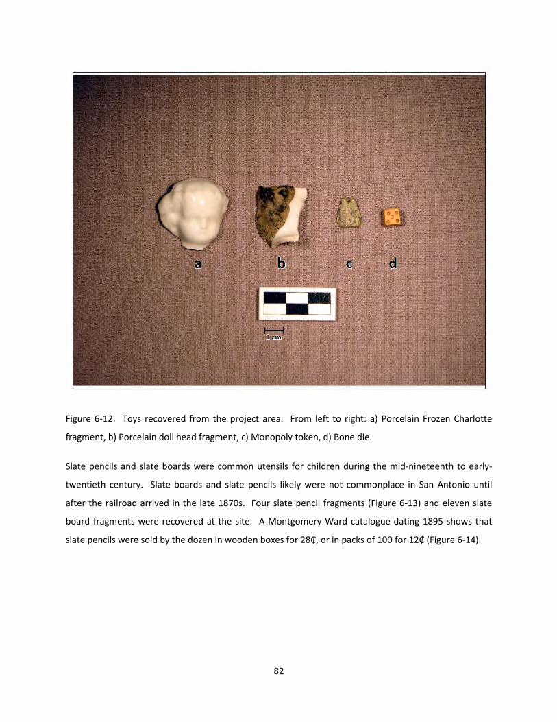
Figure 6-12. Toys recovered from the project area. From left to right: a) Porcelain Frozen Charlotte
fragment, b) Porcelain doll head fragment, c) Monopoly token, d) Bone die.
Slate pencils and slate boards were common utensils for children during the mid-nineteenth to early-
twentieth century. Slate boards and slate pencils likely were not commonplace in San Antonio until
after the railroad arrived in the late 1870s. Four slate pencil fragments (Figure 6-13) and eleven slate
board fragments were recovered at the site. A Montgomery Ward catalogue dating 1895 shows that
slate pencils were sold by the dozen in wooden boxes for 28₵, or in packs of 100 for 12₵ (Figure 6-14).
82

Figure 6-13. Four slate pencil fragments.
Figure 6-14. Excerpt from the 1895 Montgomery Ward catalogue showing slate pencil listings.
83

Chapter 7: Summary and Discussion
The augering of the parking lot located to the north of the Christopher Columbus Hall and San Francesco
di Paola Church revealed that the soils under the asphalt and base represent a mix of yellow clay and
dark grayish brown silty clay. The original ground surface that was assumed to be present under the fill
was not identified even in the auger bores that extended to seven feet below the surface. Since the
upper portion of the deposits found in the two 50-x-50 cm units excavated between the Church and
Community Hall also contained yellow clay, it is possible that the soils encountered under the asphalt
represent the parent soils that underlie the landform that forms the west bank of San Pedro Creek. It
also is possible that clay soils were brought in from another location to prepare the base for the
asphalted lot. This location could have been the grassy field that is immediately west of the parking lot.
This possibility is supported by the fact that the construction of the parking lot appears to have
coincided with the construction of the large turn-around loop that was built sometime between 1963
and 1966 in the area (Figure 3-3). If so, much of the yellow clay deposit is sterile and contains no cultural
materials and the clay substrate would not have been the best of fills on a sloping landform that is
intermittently subject to wetting from an underground spring that is in the immediate vicinity of the
Church.
Both the shovel tests and the single 1-x-1 meter unit excavated within the southern margins of the
grassy field yielded a large number of cultural materials. The materials came from the dark grayish
brown silty clay that is found immediately below the top soil. Even under the asphalted parking lot, the
only cultural materials were recovered from auger bores that encountered the dark grayish brown silty
clay soils.
Earlier in this report, a series of archaeological expectations were outlined regarding the potential
archaeological signatures of the first location of Mission San Antonio de Valero. The expectation
focused of features and facilities and material culture that may have been left behind during the 12- to
14-month occupation of the site. Here we consider the combined findings of the two field investigations
carried out at the site (UTSA-CAR and RKEI) and how they reflect upon the archaeological expectations
outlined earlier.
84

Features and Facilities
The two field projects conducted at the location have identified a single feature. The feature is a small
hearth located near the southeastern edge of the grassy field, just west of the asphalted parking lot near
the apex of the landform that borders San Pedro Creek (Nichols 2014:Figure 4-3). The southern and
eastern margins of the grassy field located to the west of the parking lot would have been immediately
outside of the area that was impacted by the turn-around loop that was built in 1966 (Figure 3-3).
No datable material has been recovered in association with the feature and therefore its age is not
known. The artifacts that were recovered in association with the feature consist of mid-20th century
materials, although their primary association with the feature is highly questionable. The morphology of
the feature suggests a shallow basin, possibly surrounded by rocks (Figure 4-3; Nichols 2014). The basin
hearth was not rock-lined suggesting very ephemeral use. As such, it may be associated either with a
proto-historic or Spanish Colonial Native American use of the study area. In addition, it may also
represent a historic Euro-American use of the feature, representing a picnic-associated cooking feature.
The other intriguing possibility is that the feature was employed as an outdoor cooking feature during
historic times but by a person of Native American descent. This possibility is supported by the presence
of several pieces of Goliad ceramics found in the general vicinity of the feature. Finally, given its near-
surface location, the hearth may also represent the remnants of a modern campfire built by homeless
people that often frequent this general vicinity of Columbus Park. This may be a less likely explanation
given that the area has been reasonably wide open and the property of the Christopher Columbus
Italian Society for a number of years and access to it has been limited.
Overall, the feature may be seen as associated either with a proto-historic or historic Spanish Colonial
Native American occupation of the location or a historic Euro-American residence. The most intriguing
possibility is that the feature could have been used by a person with Native American roots but married
into a Spanish family, such as many of the families that formed as soldiers married Native American
women as the missions were secularized during the early 19th century (1824). A less interesting option is
that the hearth is a modern creation reflective of the association of the locality with homeless
inhabitants.
The relative scarcity of features within the study area is not surprising but rather it may be the product
of the extensive land modifications that have taken place in the vicinity of the study area. Beginning
with the mid-19th century the study area has seen increasingly greater degree of development and
85

construction not only of the domestic residential type but also associated with civic and religious
character (i.e., the San Francesco di Paola Catholic Church). In addition, the construction of the IH-35
and I-10 interchange in the mid-20th century resulted in additional large-scale impacts to the landform
and the vicinity of the study area.
Artifact Assemblage
Review of the artifacts from the investigations indicates that the majority of the assemblage can be
dated to the mid-nineteenth to early-twentieth century. The excavations did not produce materials that
are commonly associated with the earliest colonial occupation of San Antonio. Overall, a small
proportion of the artifact collection that was recovered can be associated to the Spanish Colonial period
in San Antonio. However, these items, such as the majolicas and lead-glazed ceramics, span such a long
period of manufacture that they cannot be definitively linked to the earliest European occupation of the
area. In addition, the potential colonial artifacts were recovered in the same levels as the later material,
indicating either that the soils have been disturbed over the years or that the artifacts date to the later
period rather than the early portion of their temporal range.
The archaeological investigations conducted by RKEI produced a total of 723 and 5571.61 g of artifacts.
In addition, 1430 items and 6537.98 g of material were recovered during the 2013 investigations
conducted by UTSA-CAR. Furthermore, surface collections made prior to and during the UTSA-CAR
investigations identified an additional 44 artifacts, of which 30 (68%) may represent Spanish Colonial
Period-associated artifacts. The majority of the cultural material encountered during the investigations
dates from the mid-nineteenth to early-twentieth century. This should not be taken as an indicator of
the fact that the location is not the first site of the mission since it does correspond to the proportion of
time the landform would have been occupied by the mission versus the years of subsequent occupation
stretching into the 20th century (12-14 months versus nearly 300 years). Therefore, the proportional
under-representation of Spanish Colonial materials does match expectations rather than contradicts the
possibility that the location is the site of the first settlement.
The two projects produced a combined 117 artifacts that could be related to the Spanish Colonial Period
(Table 7-1). The artifacts include a small number of chipped stone artifacts, primarily unmodified lithic
debitage that represents a bi-product of stone tool manufacture. The manufacture of expedient tools is
well documented within the missions and the debris resulting from such activities should have been
some of the most common residue associated with a site. Therefore, the presence of chipped lithic
86

debris should be viewed as a positive indicator suggestive of the connection between Native American
occupants and the proto-historic or historic period. As in the case of the small hearth discussed earlier,
however, it is also possible that the materials are prehistoric in age and predate the Spanish Colonial
presence in the region. There is no clear evidence for a prehistoric association of the materials
recovered from either project, at least as it can be judged based on the lack of prehistoric temporally
diagnostic tools.
Table 7-1. List of all possible Spanish Colonial Period artifacts recovered from 41BX1968.
UTSA-CAR Excavations RKEI Excavations
All Surface Total
Unit 1 Unit 2 Unit 3 TU-1 TU-3 Augers
Shovel Test Surface
Lithic Debitage 14 9 2 1 1 2 29 Tool 1 1 2 Edge Modified 1 1 Possible Gunflint 1 1 Glass Olive Glass 4 3 3 1 11 Dark Olive Glass 1 7 1 9 Amber-Olive 1 1
Bead 3 3 Spanish Colonial Ceramics Galera 1 3 1 2 7 Yellow Lead Glazed 5 1 7 13 Unknown Sandy Paste 2 1 1 4 Green Lead Glazed 2 2 1 5 Olive Jar 1 1 Puebla Blue on White 1 1 2 4 Puebla Plain 1 1 1 3 Unknown Polychrome Majolica 1 1 Unglazed 1 1 Native American Ceramic Goliad 7 7 Metal Wrought iron fasteners 7 7 Unidentified Copper 2 2 Lead Fragments 5 5
Total 16 25 5 2 16 12 1 40 117
The lack of such tools may also be seen as indicative of the use-history of the site as it is expected that
short occupations that may result in the manufacture and discard of fewer stone tools than longer
occupations. Therefore, it may be possible to suggest that the occupation of a site for 12-14 months
would have resulted in the manufacture of formal tools that may not have exceeded their use lives prior
87

to the abandonment of the locality. Therefore, the bulk of the tools employed would have been
expedient varieties of cutting and scraping tools. However, only one expedient tool and a minimally
retouched cobble tool, were the only utilized chipped stone artifacts identified in the lithic collection.
This finding may suggest that the lithic artifacts recovered during the project may derive from a sparse
palimpsest of prehistoric cultural material accumulated on the surface that later saw the historic
occupation of the landform.
As in the case of the chipped lithic debris, the recovery of seven pieces of bone tempered pottery also
may correlate with the Native American occupation of the landform. However, the fact that one of the
pieces may actually retain a flat bottom rather than the more typical rounded base is intriguing. In
addition, the fact that both fragments are fully oxidized, even though at least the base fragment is
relatively thick, suggests that the fragments may be pieces of wheel-thrown vessels. If this is indeed the
case, the finds may correlate more directly with artifacts manufactured during the post-colonial period.
As such, they could be more directly linked to manufacture by potters with technological roots in the
Native American bone-tempered ceramic tradition.
The possible gunflint is yet another artifact that may be indicative of a Spanish Colonial connection of
the locality. The manufacture of gunflints by Native American neophytes was one way in which the
traditional lithic technology of prehistoric and proto-historic groups was modified during the
historic/Spanish Colonial Period. In particular, the expedient manufacture of gunflints, as well as the
recycling of prehistoric biface fragments, into gunflints, is a very typical approach to gunflint
manufacture by Native American flint knappers.
In addition to the aforementioned Native American-made items that were recovered from the site, a
number of additional artifacts have Spanish Colonial affinities and may date to the early 18th century.
For instance, the recovery of fragments of two blue glass trade beads (Figure 7-1) may also hint at the
possibility that some of these materials recovered from the site are associated with the Spanish Colonial
Period. Such trade beads were common presents that were given by Spanish explorers to members of
Indian Nations that they met during their exploration north of the Rio Grande River. The recovery of
three bead fragments, two of which refit into a single complete bead is suggestive of a Spanish Colonial
association.
88

Figure 7-1. Fragments of two glass beads recovered from surface prior to UTSA-CAR investigations.
Similarly, the recovery of olive and olive-amber glass may be suggestive of a Spanish Colonial
manufacture date, although olive glass has also been used in wine bottles that were manufactured at
later dates. Common use of olive glass for anything other than wine and champagne bottles ends circa
1890 (BLM 2015). Typically, when olive glass is recovered in the same context as Spanish Colonial
ceramics it is believed to be contemporaneous.
The Spanish Colonial ceramics recovered from the site include material culture would have been
dominated by tin and lead glazed wares such as Olive Jars, Yellow and Green Glazed wares, and Puebla
Blue on White (Figure 7-2) fragments. Each of these wares was being manufactured by the early 1700s.
However, they continued to be manufactured for nearly 100 years. Tin glazed wares that would be
strong indicators of the early-eighteenth century occupation of the mission site would include Abo
Polychrome and Puebla Polychrome, San Luis Polychrome, and Castillo Polychrome. Each of these types
was manufactured between the mid-seventeenth and first quarter of the eighteenth century (A.D. 1650-
1725) and therefore would be very tightly correlated to the 1718 founding date. Unfortunately
however, no fragments of these types have been found during the investigations.
89

Figure 7-2. Fragment of Puebla Blue on White recovered from surface prior to UTSA-CAR investigations.
Lead also was a common raw material in the manufacture of musket balls by presidio soldiers. The
soldiers would have needed to restock their supply of ammunition by melting lead and pouring into a
mold. During manufacture of the ammunition, the excess or seams would be trimmed (Figure 7-3). It is
possible that the lead fragments that were recovered at the site were related to the Spanish soldiers’
ammunition.
90

Figure 7-3. Lead fragments recovered from surface prior to UTSA-CAR investigation.
Wrought iron nails, spikes, and copper sheeting may also be associated with a Spanish Colonial
occupation of the site (Figure 7-4). At the time the expedition reached San Antonio, the only method of
producing metal objects such as nails, spikes, wire, horseshoes, and blades was through forging. Forged
metal would have needed high heats as well as a trained blacksmith. The objects would have been
important items transported into San Antonio as part of the supplies of the expedition until the villa and
missions could be established and a local blacksmith set up shop. After the colonial period, metal
manufacturing changed, and common goods such as nails and spikes would have been made through
the cutting process (i.e. cut nails), and later the use of machines replaced hand manufacturing with
automation. Copper sheets and patches were commonly found in the kits that the settlers and soldiers
brought with them. Should a pot crack, it was necessary to repair the pot rather than wait in hopes that
the next supply wagon would have new copper pots to sell. Once supplies more readily and reliably
made their way into San Antonio, the need for patching cracked pots and other metal objects was not as
necessary.
91

Figure 7-4. Possible forged nails recovered at the site.
Overall, however, when the temporal range of the ceramic sherds is consider, it is evident that the
Spanish Colonial artifacts recovered from the site can be attributed to a nearly 80 year long time period
(1718-1800). Unfortunately, because there is no way in which to narrow the temporal affiliation of the
materials recovered, it is not possible to link any one artifact to a narrow calendar date that is closely
linked to the one-year period when the mission was constructed and was occupied at the first site.
Currently there is not enough evidence to conclusively deduce that Mission San Antonio de Valero was
located at this site. Further investigations will likely not produce needed evidence to support the claim
due to the amount of disturbance. Therefore, RKEI does not recommend further investigations in the
area to locate remnants of the first Mission San Antonio de Valero. It may be likely, however, that
further archival research in primary source documents located in research libraries and depositories in
Mexico and Spain could help shed light on this founding period including potential clues that may help
archaeologists pinpoint additional diagnostic artifacts and features that may serve to unequivocally link
41BX1968 to the first site of the mission.
92

References
Almaraz, F.D. Jr. 1989 The San Antonio Missions and Their System of Land Tenure. University of Texas Press. Austin,
Texas.
Arneson, E. 2015 What tokens were originally included? What tokens are included today?
http://boardgames.about.com/od/monopolyfaq/f/tokens.htm. Accessed March 2015.
Belfiglio, V. 1995 Italian Experience in Texas: A Closer Look. Eakin Press. Austin, Texas.
BLM (Bureau of Land Management) 2015 Historic Glass and Bottle Identification and Information Website. Bureau of Land Management
and Society for Historical Archaeology. http://www.sha.org/bottle/. Accessed March 2015.
BCAD (Bexar County Appraisal District) Electronic Documents, http://www.bcad.org/clientdb/?cid=1. Accessed March 2015.
BCDR (Bexar County Deed Records) Electronic Resources, https://gov.propertyinfo.com/tx-bexar/. Accessed March 2015.
Carpentier, D. and J. Rickard 2001 Slip Decoration in the Age of Industrialization. In Ceramics in America edited by R. Hunter, pp.
115-134. Chipstone Foundation, Milwaukee.
Chabot, F.C. 1937 With the Makers of San Antonio. Artes graficas. San Antonio, Texas. Available at
http://digital.library.villanova.edu/Item/vudl:239303.
CCMM (City Council Meeting Minutes) http://www.sanantonio.gov/clerk/archivesearch/AdvancedSearch.aspx
CCO (City Council Ordinance) Electronic documents, http://www.sanantonio.gov/clerk/ArchiveSearch/AdvancedSearch.aspx.
Accessed March 2015.
CCIS (Christopher Columbus Italian Society) 2015 History of the Society. On Christopher Columbus Italian Society website. http://ccis-
satx.org/history.html. Accessed March 2015.
Cox, I.W. 2005 The Spanish Acequias of San Antonio. Maverick Publishing Company. San Antonio, Texas.
93

De la Teja, J.F 1995 San Antonio de Bexar: A Community on New Spain’s Northern Frontier. University of New
Mexico Press. Albuquerque.
Ewins, N 2008 Comparative Studies in Anglo-American Ceramic Demand. In Ceramics in America edited by R.
Hunter, pp. 109-142. Chipstone Foundation, Milwaukee.
FLMNH (Florida Museum of Natural History) 2015 Historical Arhcaeology. Digital Type Collections.
http://www.flmnh.ufl.edu/histarch/gallery_types/type_index_display.asp?type_name=YELLOW%20WARE. Accessed March 2015.
Fox, A.A., M. Renner, and R.J. Hard 1997 Archaeology at the Alamodome: Investigations of a San Antonio Neighborhood in Transition.
Volume III: Artifacts and Special Studies. Archaeological Report No. 238. Center for Archaeological Research, The University of Texas at San Antonio.
Habig, M.A. 1968 The Alamo Chain of Missions: A History of San Antonio’s Five Oldest Mission. Franciscan Herald
Press, Chicago. 1990 Spanish Texas Pilgrimage. Franciscan Herald Press, Chicago. Hitchcock, R.K. 1985 Sedentism and Site Structure: Organizational Changes in Kalahari Basarwa Residential Locations.
In Methods and Theory for Activity Area Research: An Ethnoarchaeological Approach, edited by S. Kent, pp. 374-423. Columbia University Press, New York.
Hoffman, Fritz L., translator 1935 Diary of the Alarcón Expedition Into Texas, 1718-1719. The Quiviria Society Publications Volume
V. Lancaster Press, Inc., Lancaster PA. 1938 The Mezquía Diary of the Alarcon Expedition Into Texas, 1718. Southwestern Historical Quarterly
41(April 1938): 312-323.
Institute of Texan Cultures 1973 The Italian Texans. The University of Texas at San Antonio Institute of Texan Cultures. San
Antonio, Texas. Ivey, J.E., M.B. Thurber, and S. Escobedo 1990 Of Various Magnificence. The Architectural History of the San Antonio Missions in the Colonial
Period and the Nineteenth Century. Volume I. National Park Service, Southwest Regional Office, Santa Fe, New Mexico.
Kelly, H.E., A.A. Kowalsky, and D.E. Kowalsky 2001 Spongeware 1835-1935: Makers, Marks, and Patters. Schiffer Publishing Ltd. Pennsylvania.
94

Kendrick, G. 1966 The Antique Bottle Collector. Edward Brothers, Inc. Ann Arbor, Michigan.
Labadie, J.H., K.M. Brown, A.A. Fox, S.P. Nesmith, P.S. Storch, D.D. Turner, S. Van der Veer, and A.J. Winkler 1986 La Villita Earthworks (41BX677): A Preliminary Report of Investigations of Mexican Siege Works
at the Battle of the Alamo. Archaeological Report No. 159. Center for Archaeological Research, The University of Texas at San Antonio.
Logan, H.C. 1959 Cartridges: A Pictorial Digest of Small Arms Ammunition. Bonanza Books, New York.
MHS (Maine Historical Society) 2015 Maine Memory Network: Shingling hatchet. Digital resource.
https://www.mainememory.net/artifact/11933. Accessed September 2015.
Newman, M 2013 The Story Behind Monopoly Pieces. On Cool Material. http://coolmaterial.com/feature/the-
story-behind-monopoly-pieces/. Accessed March 2015.
Nichols, K.M. 2014 Archaeological Investigations at the Christopher Columbus Society Property and Columbus Park:
41BX1968, the Possible First Site of Mission San Antonio de Valero. Archaeological Report No. 432. Center for Archaeological Research, The University of Texas at San Antonio.
Pilon, M. 2015 Monopoly Was Designed to Teach the 99% About Income Inequality. Smithsonian Magazine.
January 2015. http://www.smithsonianmag.com/arts-culture/monopoly-was-designed-teach-99-about-income-inequality-180953630/. Accessed March 2015.
SAMA (San Antonio Municipal Archives) 2015a. Subdivision, Civil Engineer, Survey Book 1, Page 377 of 478. http://www.sanantonio.gov/clerk/archivesearch/AdvancedSearch.aspx. Accessed March 2015. 2015b. City Council Ordinance Book NN March 13, 1963 - March 27, 1963. http://www.sanantonio.gov/clerk/archivesearch/AdvancedSearch.aspx. Accessed March 2015.
Santos, Richard, G. translator 1981 Aguayo Expedition into Texas. Jenkins Publishing Company, Austin, Texas.
Tennis, C. A. 1995 Exhumation of a Hero, Colonel Ben Milam, Milam Park Renovation Phase I, with Contributions by
Douglas W. Owsley, Karin L. Sandness, and Barbara A. Winkler. Technical Report, San Antonio: Center for Archeological Research, University of Texas San Antonio.
95

Tolson, H., E. Gerth, and N.C. Dobson 2008 Ceramics from the “Blue China” Wreck. In Ceramics in America edited by R. Hunter, pp. 163-
185. Chipstone Foundation, Milwaukee.
Tomka, S.A., A.L. Figueroa, L. Carbajal, and E. Poble 2013 Standing Structure Survey of a Portion of San Pedro Creek, San Antonio, Bexar County, Texas.
Technical No. 51. Center for Archaeological Research, The University of Texas at San Antonio.
Tomka, S.A. and J. J. Dowling 2009 Data Recovery at 41BX1798: The Miraflores Park Bridge Project. Archaeological Report No. 405.
Center for Archaeological Research, The University of Texas at San Antonio.
Tous, G 1930 The Espinosa-Olivares-Aguirre Expedition of 1709. In Preliminary Studies of the Texas Catholic
Historical Society. The Knights of Columbus Historical Commission.
Ulrich, K.M., J.L. Thompson, K. Hindes, B.K. Moses, J.J. Dowling, L.K. Wack, and B.A. Meissner 2010 Testing and Data Recovery at the Perez Ranch (41BX274). Archaeological Report No. 404.
Center for Archaeological Research, The University of Texas at San Antonio.
USDA (United States Department of Agriculture) 2015 An Axe to Grind: A Practical Ax Manual. United States Forestry Service, Technology
Development Program. http://www.fs.fed.us/eng/pubs/htmlpubs/htm99232823/page02.htm. Accessed March 2015.
Villalobos, C.R. 2003 A Study of Gunflints from Spanish Sites. Unpublished Master’s Thesis, Anthropology. The
University of Texas at San Antonio.
Visser, T.D. 1997 Field Guide to New England Barns and Farm Buildings. University Press of New England. New
Hampshire.
Wagner, H.R. 1967 The Spanish Southwest, 1542-1794. Arno Press. New York.
Weddle, R.S. 1968 San Juan Bautista Gateway to Spanish Texas. University of Texas Press, Austin.
96

Appendix A: Photographs of Artifacts that Potentially Relate to the Spanish
Colonial Period
Appendix A present the artifacts that were recovered either during field visits conducted by City
Archaeologist, Kay Hindes, or during the UTSA-CAR field investigations. The Christopher Columbus
Society loaned the collection to RKEI for photographing.
Figure A-1. Possible forged nails.
97

Figure A-2. Cuprous artifact, possible button.
Figure A-3. Forged metal objects.
98

Figure A-4. Horse/Mule shoe fragments.
Figure A-5. Lead fragments.
99

Figure A-6. Lead fragments. Left: Nail Seal (not colonial). Right: lead disk.
Figure A-7. Cuprous loop shank button.
100

Figure A-8. Possible forged spike.
Figure A-9. Lead glazed ceramics.
101

Figure A-10. Galera ware fragments recovered from surface and UTSA-CAR investigations.
Figure A-11. Lead glazed ceramics, likely undecorated fragments of Galera ware.
102

Figure A-12. High-fired lead glazed ceramics.
Figure A-13. Puebla Blue on White tin glazed ceramic.
103

Figure A-14. Heavily patinated glass. Left: amber glass. Right: light olive glass.
Figure A-15. Fragments of two glass beads.
104

Figure A-16. Chert debitage recovered from the site.
105


