Salt Production in Syracuse, New York (The Salt … · Salt Production in Syracuse, New York ("The...
8
uses science for a changing world Prepared in cooperation with Onondaga Lake Cleanup Corporation, U.S. Environmental Protection Agency-Region 2, New York State Department of Environmental Conservation Salt Production in Syracuse, New York ("The Salt City") and the Hydrogeology of the Onondaga Creek Valley The Salt Industry, Tully Farms, N Brine from springs in and around the southern end of Onondaga Lake, from former brine wells dug or drilled at the lakes' edge, and from wells that tapped halite (common salt) beds near Tully, N.Y., 15 miles south of Syracuse, were used commercially from the late 1700's through the early 1900's for salt production. The rapid development of this industry in tie 18th and 19th centuries led to the nicknaming of Syracuse as "The Salt City." The brine originates from halite beds of the Salina C roup shales of central New York. The dissolution of halite by ground water creates a brine that moves through an unconsolidated basal aquifer northward to the springs near Syracuse. This report briefly presents the history of salt production in the Syracuse area, explains the origin of the halite deposits and the ground-water flow paths from the halite beds to Onondaga Lake, and discusses the need to understand the hydrogeology of the Onondaga Valley and potential changes in water quality (specifically salt water) in relation to current remediation of Onondaga Lake and other contaminated sites in the Onondaga Creek watershed. Department of the Interior U.S. Geological Survey Fact Sheet FS 139-00 November 2000
Transcript of Salt Production in Syracuse, New York (The Salt … · Salt Production in Syracuse, New York ("The...

usesscience for a changing world
Prepared in cooperation with Onondaga Lake Cleanup Corporation, U.S. Environmental Protection Agency-Region 2, New York State Department of Environmental Conservation
Salt Production in Syracuse, New York ("The Salt City") and the Hydrogeology of the Onondaga Creek Valley
The Salt Industry, Tully Farms, N
Brine from springs in and around the southern end of Onondaga Lake, from former brine wells dug
or drilled at the lakes' edge, and from wells that tapped halite (common salt) beds near Tully, N.Y., 15
miles south of Syracuse, were used commercially from the late 1700's through the early 1900's for salt
production. The rapid development of this industry in tie 18th and 19th centuries led to the nicknaming
of Syracuse as "The Salt City."
The brine originates from halite beds of the Salina C roup shales of central New York. The dissolution
of halite by ground water creates a brine that moves through an unconsolidated basal aquifer northward
to the springs near Syracuse. This report briefly presents the history of salt production in the Syracuse
area, explains the origin of the halite deposits and the ground-water flow paths from the halite beds to
Onondaga Lake, and discusses the need to understand the hydrogeology of the Onondaga Valley and
potential changes in water quality (specifically salt water) in relation to current remediation of Onondaga
Lake and other contaminated sites in the Onondaga Creek watershed.
Department of the Interior U.S. Geological Survey
Fact Sheet FS 139-00 November 2000
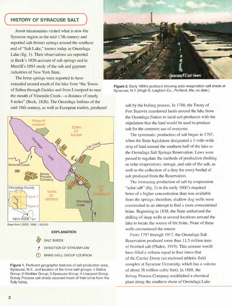
C HISTORY OF SYRACUSE SALT JJesuit missionaries visited what is now the
Syracuse region in the mid-17th century and reported salt (brine) springs around the southern end of "Salt Lake," known today as Onondaga Lake (fig. I). Their observations are reported in Beck's 1826 account of salt springs and in Merrill's 1893 study of the salt and gypsum industries of New York State.
The brine springs were reported to have extended around much of the lake from "the Towns of Salina through Geddes and from Liverpool to near the mouth of Ninemile Creek a distance of nearly 9 miles" (Beck, 1826). The Onondaga Indians of the mid-18th century, as well as European traders, produced
Onondaga County
Figure 1
Figure 3
Base from USGS, 1898, 1:48,000
EXPLANATION
^ SALT SHEDS
f DIRECTION OF STREAMFLOW
0 BRINE WELL GROUP LOCATION
Figure 1. Pertinent geographic features of salt-production area, Syracuse, N.Y., and location of the brine well groups: 1-Salina Group; 2-Geddes Group; 3-Syracuse Group; 4-Liverpool Group. Solvay Process salt sheds received much of their brine from the Tully Valley.
Figure 2. Early 1900's postcard showing solar-evaporation salt sheds at Syracuse, N.Y. (Hugh G. Leighton Co., Portland, Me, no date.)
salt by the boiling process. In 1788, the Treaty of Fort Stanwix transferred lands around the lake from the Onondaga Nation to local salt producers with the stipulation that the land would be used to produce salt for the common use of everyone.
The systematic production of salt began in 1797, when the State legislature designated a 1-mile-wide strip of land around the southern half of the lake as the Onondaga Salt Springs Reservation. Laws were passed to regulate the methods of production (boiling or solar evaporation), storage, and sale of the salt, as well as the collection of a duty for every bushel of salt produced from the Reservation.
The increasing production of salt by evaporation "solar salt"' (fig. 2) in the early 1800's required brine of a higher concentration than was available from the springs; therefore, shallow dug wells were constructed in an attempt to find a more concentrated brine. Beginning in 1838. the State authorized the drilling of deep wells at several locations around the lake to locate the source of the brine. None of these wells encountered the source.
From 1797 through 1917, the Onondaga Salt Reservation produced more than 11.5 million tons of finished salt (Phalen, 1919). This amount would have filled a volume equal to four times that of the Carrier Dome (an enclosed athletic-field complex at Syracuse University, which has a volume of about 38 million cubic feet). In 1888, the Solvay Process Company established a chemical plant along the southern shore of Onondaga Lake
(fig. 1) to manufacture soda ash from the halite and limestone resources found within the local bedrock. The concentration of brine from the springs and wells in the Salt Reservation was diminishing, however, and this forced the company to seek additional sources of brine.
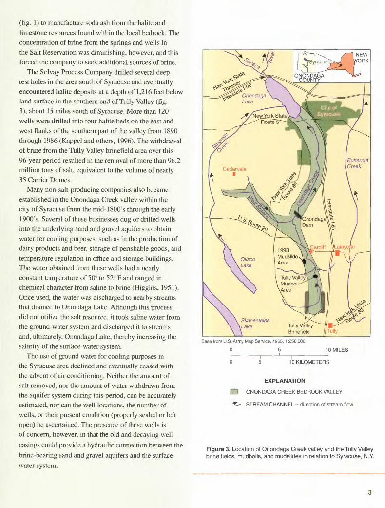
The Solvay Process Company drilled several deep test holes in the area south of Syracuse and eventually encountered halite deposits at a depth of 1,216 feet below land surface in the southern end of Tully Valley (fig. 3), about 15 miles south of Syracuse. More than 120 wells were drilled into four halite beds on the east and west flanks of the southern part of the valley from 1890 through 1986 (Kappel and others, 1996). The withdrawal of brine from the Tully Valley brinefield area over this 96-year period resulted in the removal of more than 96.2 million tons of salt, equivalent to the volume of nearly 35 Carrier Domes.
Many non-salt-producing companies also became established in the Onondaga Creek valley within the city of Syracuse from the mid-1800's through the early 1900's. Several of these businesses dug or drilled wells into the underlying sand and gravel aquifers to obtain water for cooling purposes, such as in the production of dairy products and beer, storage of perishable goods, and temperature regulation in office and storage buildings. The water obtained from these wells had a nearly constant temperature of 50° to 52° F and ranged in chemical character from saline to brine (Higgins, 1951). Once used, the water was discharged to nearby streams that drained to Onondaga Lake. Although this process did not utilize the salt resource, it took saline water from the ground-water system and discharged it to streams and, ultimately, Onondaga Lake, thereby increasing the salinity of the surface-water system.
The use of ground water for cooling purposes in the Syracuse area declined and eventually ceased with the advent of air conditioning. Neither the amount of salt removed, nor the amount of water withdrawn from the aquifer system during this period, can be accurately estimated, nor can the well locations, the number of wells, or their present condition (properly sealed or left open) be ascertained. The presence of these wells is of concern, however, in that the old and decaying well
casings could provide a hydraulic connection between the
brine-bearing sand and gravel aquifers and the surface-
water system.
Base from U.S. Army Map Service, 1965, 1:250,000
0 10 MILES
10 KILOMETERS
EXPLANATION
ONONDAGA CREEK BEDROCK VALLEY
STREAM CHANNEL -- direction of stream flow
Figure 3. Location of Onondaga Creek valley and the Tully Valley brine fields, mudboils, and mudslides in relation to Syracuse, N.Y.
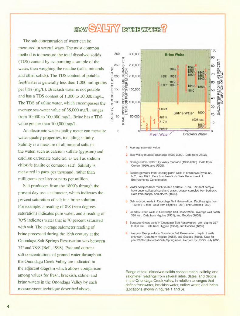
The salt concentration of water can be
measured in several ways. The most common
method is to measure the total dissolved solids
(TDS) content by evaporating a sample of the
water, then weighing the residue (salts, minerals
and other solids). The TDS content of potable
freshwater is generally less than 1,000 milligrams
per liter (mg/L). Brackish water is not potable
and has a TDS content of 1,000 to 10,000 mg/L.
The TDS of saline water, which encompasses the
average sea-water value of 35,000 mg/L, ranges
from 10,000 to 100.000 mg/L. Brine has a TDS
value greater than 100,000 mg/L.
An electronic water-quality meter can measure
water-quality properties, including salinity.
Salinity is a measure of all mineral salts in
the water, such as calcium sulfate (gypsum) and
calcium carbonate (calcite), as well as sodium
chloride (halite or common salt). Salinity is
measured in parts per thousand, rather than
milligrams per liter or parts per million.
Salt producers from the 1800's through the
present day use a salometer, which indicates the
percent saturation of salt in a brine solution.
For example, a reading of 0°S (zero degrees
saturation) indicates pure water, and a reading of
70°S indicates water that is 70 percent saturated
with salt. The average salometer reading of
brine processed during the 19th century at the
Onondaga Salt Springs Reservation was between
74° and 78°S (Bell, 1998). Past and current
salt concentrations of ground water throughout
the Onondaga Creek Valley are indicated in
the adjacent diagram which allows comparison
among values for fresh, brackish, saline, and
brine waters in the Onondaga Valley by each
measurement technique described above.
300
250
1 200oXI-DC £150
I °-100
50
300,000 DCLLJ 0_w 250,000
200,000=!^^rr cog 9 W 150,000Orr
100,000
Off
50,000
7 Brine Water
: 1842 1
1851,1853*
* 1 858 a~ c 633 ft 1840*
_
i
"
-- o
i*2 1 "
0 1.608ft
1842^
185101853 1858
1840
1840
*., - .
Saline Water462ft
517ft
ni-M-i x.1
ar*jJ 1uHHP^ n
-
1842-, 185f6 1840 w ~
i
1858* --
-
_
1900J ~
1925est.B -
1950P2000^ -
90
80
70
60
50
40
30
20
10
n
%°o:^ cc=>
LJW
O
Fresh Water- Brackish Water
1 Average seawater value
2 Tully Valley mudboil discharge (1992-2000). Data from USGS.
3 Springs within 1993 Tully Valley mudslide (1993-2000). Data from Curran (1999), and USGS.
4 Discharge water from "cooling plant" wells in downtown Syracuse, N.Y., July 1991. Data from New York State Department of Environmental Conservation.
5 Water samples from mudboil-area drillhole -1994. 298-foot sample from unconsolidated sand and gravel; deeper samples from bedrock. Data from Kappel and others, (1996).
6 Salina Group wells in Onondaga Salt Reservation. Depth ranges from 132 to 312 feet. Data from Higgins (1951), and Geddes (1859).
7 Geddes Group wells in Onondaga Salt Reservation. Average well depth 338 feet. Data from Higgins (1951), and Geddes (1859).
8 Syracuse Group wells in Onondaga Salt Reservation. Well depths 237 to 360 feet. Data from Higgins (1951), and Geddes (1859).
9 Liverpool Group wells in Onondaga Salt Reservation, depth of wells unknown. Data from Higgins (1951), and Geddes (1859). Data for year 2000 collected at Gale Spring near Liverpool by USGS, July 2000.
Range of total dissolved-solids concentration, salinity, and salometer readings from several sites, dates, and depths in the Onondaga Creek valley, in relation to ranges that define freshwater, brackish water, saline water, and brine. (Locations shown in figures 1 and 3).

GEOLOGIC AND GLACIAL HISTORY OF THE ONONDAGA CREEK VALLEY AND SYRACUSE REGION
Between 500 million and 300 million years ago, a mountain range as high as the present-day Himalayas formed along what is now the East Coast of North America as result of the collision of two landmasses that are now the European and North American continents. As the mountain range gradually rose, a large, shallow depression to the west became inundated to form an inland sea. Precipitation and runoff over millions of years slowly eroded the mountain range and deposited thousands of feet of sediment into the inland sea. Much of this sediment was in the form of mud and later became consolidated into the thick layers of shale that are found beneath the Syracuse area. Layers of limestone and sandstone also formed, and evaporation from the shallowest areas left layers of evaporites (salts) such as calcium sulfate (gypsum), calcium carbonate (calcite), and sodium chloride (halite or common salt) within the muddy sediments. The northern shore of the inland sea during the period of mineral-salt formation was about 5 miles south of today's city of Syracuse. The salt beds were subsequently buried by sediments produced through the continued erosion of the mountain range. These sediments eventually filled the inland sea, mostly with mudlike material that would become the shales found in the Syracuse region today.
The Salina Group Shales (first described in Salina, N.Y.; figs. 1, 3) consist of layers of shale interbedded with remnant salt-crystal casts. The beds of halite (rock salt) within the Salina Group begin near Cedarvale (fig. 3) and thicken southward (fig. 4). The composite salt thickness in the Tully area is about 150 feet, and the salt lies at a depth of about 1,300 feet below land surface. Further south, near the Pennsylvania border, the total salt thickness is more than 500 feet, and the salt lies at a depth of more than 2,000 feet below land surface (Rickard, 1969).
The halite beds that supply the brine springs at Onondaga Lake are south of Syracuse at depths greater than 1,000 feet. The northward movement of brine to the southern shore of Onondaga Lake results from artesian pressure, driven by elevational differences between the southern Tully Valley and Onondaga Lake. The unconsolidated glacial materials above the bedrock in the Onondaga Creek valley provide a the hydraulic connection between the halite deposits and the springs, as explained in the following section.
Beginning about 1.6 million years ago, massive ice sheets flowed southward (several times) across the North American continent (Isachsen and others, 1991). The last period of glaciation, known as the Wisconsin period,
began about 100,000 years ago and ended about 14,000 years ago. The weight and force of the 1-mile-thick, southward-moving ice sheet eroded hilltops and widened and deepened river valleys. These valleys in central New York are now known as the Finger Lake valleys one of which is the Tully Valley (fig. 3). Glacial scouring in the northern part of the Tully Valley exposed the halite-bearing Salina Group Shales to ground water in the base of the bedrock valley, near U.S. Route 20 and along the flanks of the West Branch valley of Onondaga Creek (figs. 3, 4).
The last major advance of the Wisconsin-aged glacier, about 20,000 years ago, also created large end moraines (mounds of glacial debris) at the southern end of the Finger Lake valleys. These moraines blocked the southward drainage of these valleys, and, as a result, the vast amounts of meltwater from the melting glacier formed proglacial lakes between the ice front to the north, the moraine to the south, and the east and west valley walls. The sediment discharged from the glacier formed deposits several hundred feet thick in each of the Finger Lake valleys. The coarse sediment particles (gravel and sand) were deposited close to the melting ice where the meltwater streams entered the lakes. The finer particles (silt and clay) were transported farther into the lakes, where they settled and capped the coarser deposits. Therefore, each Finger Lake valley's bedrock floor is overlain by coarse gravel and sand deposits and are overlain in many places by varying thicknesses of silt and clay.
This sediment sequence was confirmed by Mullens and others (1991), who studied the valley-fill sediments of eight Finger Lakes through marine-seismic-survey techniques. They found gravelly deposits overlying the bedrock floor, capped by mixed, finer grained deposits of clay, silt, and sand. The basal gravelly deposits appeared to be nearly continuous, to meander along the north-south axis of each valley and to form a basal, confined aquifer that is a conduit for water (or brine) movement.
After the glacier had retreated northward out of the Onondaga Valley, it began to discharge water and sediment onto the Lake Ontario Plain north of Syracuse (fig. 4). Glacial deposits on the Lake Ontario Plain differ from those in the Finger Lake valleys in that they are poorly sorted and are much thinner than those found in the narrow Finger Lake valleys.
Soil borings from construction projects around Onondaga Lake indicate that the glacial deposits around the lake range from fine to coarse but at the southeastern end of the lake, near the mouth of the Onondaga Creek valley, these deposits contain a high percentage of sand
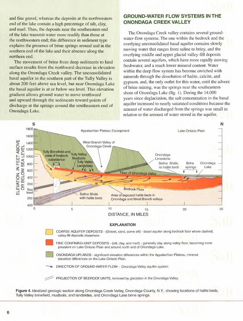
and fine gravel, whereas the deposits at the northwestern end of the lake contain a high percentage of silt, clay, and marl. Thus, the deposits near the southeastern end of the lake transmit water more readily than those at the northwestern end; this difference in sediment type explains the presence of brine springs around and in the southern end of the lake and their absence along the northern end.
The movement of brine from deep sediments to land surface results from the northward decrease in elevation along the Onondaga Creek valley. The unconsolidated basal aquifer in the southern part of the Tully Valley is about 200 feet above sea level, but near Onondaga Lake the basal aquifer is at or below sea level. This elevation gradient allows ground water to move northward and upward through the sediments toward points of discharge at the springs around the southeastern end of Onondaga Lake.
GROUND-WATER FLOW SYSTEMS IN THE ONONDAGA CREEK VALLEY
The Onondaga Creek valley contains several ground- water-flow systems. The one within the bedrock and the overlying unconsolidated basal aquifer contains slowly moving water that ranges from saline to briny, and the overlying middle and upper glacial valley-fill deposits contain several aquifers, which have more rapidly moving freshwater, and a much lower mineral content. Water within the deep flow system has become enriched with minerals through the dissolution of halite, calcite, and gypsum, and, the only outlet for this water, until the advent of brine mining, was the springs near the southeastern shore of Onondaga Lake (fig. 1). During the 14,000 years since deglaciation. the salt concentration in the basal aquifer increased to nearly saturated conditions because the amount of water discharged from the springs was small in relation to the amount of water stored in the aquifer.
N1800
LLJ
Appalachian Plateau Escarpment Lake Ontario Plain
West Branch Valley of Onondaga Creek
Tully Brinefield and area of bedrock Tully Valley Onondaga
Limestone Salina Shale, no halite beds
Mudboils ' Tully Valle Landslides
\\
Onondaga Lake
Floor of Onondaga Valley,
Salina Shale with halite beds
Area ofexposed halite beds in Onondaga and West Branch valleys
10 15
DISTANCE, IN MILES
EXPLANATION
I I COARSE AQUIFER DEPOSITS - (Gravel, sand, some silt) - basal aquifer along bedrock floor where dashed, valley-fill deposits elsewhere.
^| FINE CONFINING-UNIT DEPOSITS - (silt, clay, and marl) - generally clay along valley floor, becoming more prevalent on Lake Ontario Plain and around north end of Onondaga Lake.
It j ONONDAGA UPLANDS - significant elevation differences within the Appalachian Plateau, minimal elevation differences on the Lake Ontario Plain.
-^ DIRECTION OF GROUND-WATER FLOW - Onondaga Valley aquifer system.
;;:::::::: PROJECTION OF BEDROCK UNITS, removed by glaciation in the Onondaga Valley.
Figure 4. Idealized geologic section along Onondaga Creek Valley, Onondaga County, N.Y., showing locations of halite beds, Tully Valley brinefield, mudboils, and landslides, and Onondaga Lake brine springs.
The pumping of brine to the surface for salt production in the early 1800's, increased the amounts of brine leaving the deep ground-water flow system. The lowering of the outlet of Onondaga Lake at the Seneca River in 1822, lowered the water table around the lake and caused the brine springs to flow at higher rates than before. Subsequent increases in the rate of brine withdrawal from deep wells drilled near the lake in the mid-1800's allowed freshwater from the valley walls and the middle and upper aquifers throughout the Onondaga Creek Valley to recharge the deeper aquifer system and dilute the brine at depth. The resulting dilution caused the salt industry in Syracuse to decline by the late 1800's because the less concentrated brine required more time for evaporation, and yielded less salt than a more highly concentrated brine. At the same time, hard-rock mining of salt in other parts of the state and nation had become more productive and quickly eclipsed the importance of the Onondaga Salt Springs Reservation.
FUTURE IMPLICATIONS OF BRINE SPRINGS FOR ONONDAGA LAKE AND SYRACUSE
The closing of the Onondaga Salt Springs Reservation in the early 1900's, and the cessation of brine mining in the southern part of Tully Valley in the late 1900's, ended the final chapter of salt mining in the Syracuse region, but ground-water flowpaths along the southeastern shore of Onondaga Lake in Syracuse still allow salty water to migrate from the deep flow system to the springs in and around the lake. In the Tully Valley, however, bedrock subsidence and fracturing that resulted from nearly 100 years of halite removal have altered the local ground-water- flow system. The massive bedrock units that separate the Salina Group halite layers from the overlying bedrock units in the southern part of the valley became highly fractured as a consequence of the subsidence of the mined halite layers. The entire overlying bedrock sequence that extends upward from the mined-out halite zones to land surface has become fractured and provides hydraulic connections between bedrock aquifers (which were previously not connected), and to the adjacent valley-fill aquifers (Yanosky and Kappel, 1997). Thus, the bedrock and the unconsolidated aquifers in the southern end of the Tully Valley are now hydraulically connected and allow the migration of salty water to the valley-fill aquifer.
This hydraulic connection in the Tully Valley could increase the quantity, and diminish the quality, of water that flows through the rest of the Onondaga Creek valley aquifer system. No industries are known to be tapping the valley-fill aquifer near Syracuse, but water whose quality may vary from saline to a weak brine continues to discharge from the old springs around and beneath the
lake. The old cooling-plant wells, if they were not sealed after they were abandoned, also could provide migration pathways for saline to brine-laden water, as could other manmade flowpaths between aquifers, such as construction borings, deep pilings, or other excavations. If more highly concentrated salt water is now entering the basal aquifer in the Tully Valley, it could, in time, discharge from the springs or along old well casings near Onondaga Lake and warrant consideration in any long-term plans for water- quality remediation in and around the Lake.
SUMMARY AND CONCLUSIONS
The deep and shallow aquifer systems in the Onondaga Creek Valley provided the brine that built "The Salt City." The processes of glaciation and deglaciation eroded and modified the bedrock foundation of shale, limestone, and evaporite deposits, and the deposition of glacial deposits within the valley created the aquifers that provide a hydraulic connection between the halite deposits south of the city and the salt springs that discharge along and beneath the southeastern end of Onondaga Lake. The water-quality changes brought about by man's activities in the Onondaga Valley aquifer system over the past 200 years are unknown and cannot be reliably estimated. The compilation of available hydrogeologic information, the collection of new data, and the construction of a ground-water flow model could provide information on the changes in the quantity and quality of water discharged from the aquifer system over the last 200 years, and would allow simulation of the effects of future remediation efforts on the water quality of Onondaga Lake and the ground- water flowing to it.
by William M. Kappel
Illustrations by Kristin Linsey Layout & Graphic Design by Patricia Lee
For More Information Contact:Subdistrict Chief U.S. Geological Survey 30 Brown Road Ithaca, NY 14850

CHARACTERIZATION OF THE ONONDAGA VALLEY AQUIFER SYSTEM
The aquifer system in the Onondaga Creek valley is affected by the geology of the entire valley; thus, the
planning and implementation of ground-water-mitigation
projects for the cleanup of Onondaga Lake and other contaminated sites in the Onondaga Creek basin require extensive hydrogeologic data. Such data will help to define the interaction between ground water and surface water and
the relation between human activities that affect a given part of the aquifer and the results of those actions elsewhere.
A detailed characterization of the aquifer system would require the construction of conceptual models of the
geology and hydrology of the valley; this endeavor would require geologic and hydrologic data, as well as several other types of information:
Geologic data: Test-hole drilling data for construction activities (buildings, roads, bridges) are available but need
to be compiled and plotted to indicate the depth to bedrock, the stratigraphy of the overlying glacial sediments, and the extent and water-bearing capability of each stratum.
Hydrologic data: Test-hole information, well records, and water-level data on the various aquifers in the valley would need to be compiled and plotted to indicate the rate of ground-water flow within each aquifer and any connections between these aquifers.
Other information: Analysis of the above data would indicate the locations from which further information
is needed. Test holes in those areas would provide the additional data needed to complete the conceptual models of the aquifer system.
Once the conceptual geologic and hydrologic models are developed, a mathematical model of the ground-water-flow system can be constructed. The model can then be calibrated against data collected before and during model development and can then be used to predict future ground-water flow
patterns and water-quality conditions throughout the aquifer
system; it also could be used to simulate the interactions between aquifers and Onondaga Lake. If enough data are available, the model might also be used to simulate historical aquifer conditions to indicate how they may have been altered by man's activities.
SELECTED REFERENCES
Beck, Lewis C., 1826, An account of the salt springs at Salina, in Onondaga County, State of New York: New York, J. Seymour printer, 36 p.
Bell, Valeric, J., 1998, The Onondaga New York Salt Works (1654-1926): Onondaga County Office of Museums, Liverpool, N.Y., accessed January 19, 2000, at URL http://www.tribunes.com/tribune/sel/bell.htm
Curran, C.A., 1999, Saline springs of the 1993 Tully Valley landslide area evidence of brine migration and long term degradation of water quality in the Tully Valley, central New York: Syracuse, N.Y., Syracuse University Department of Civil and Environmental Engineering, unpublished master's thesis, 134 p.
Geddes, George, 1859, Chapter 3, Salt Springs: in Charles Van Benthuysen, ed., Transactions of the New York State Agricultural Society, Annual Report of New York State Agricultural Society, Albany New York: v. 29, p. 10-31.
Higgins, Jr., G.L., 1951, Saline ground water at Syracuse, New York: Syracuse University Department of Geology, unpublished master's thesis, 87 p.
Isachsen. Y.W., Landing, Ed, Lauber, J.M., Rickard, L.V., and Rogers, W.B., 1991, Geology of New York a simplified account; Albany, N.Y, New York State Museum-Geological Survey, Educational Leaflet no. 28, 284 p.
Kappel, W.M., Sherwood, D.L., and Johnston, W.H., 1996, Hydrogeology of the Tully Valley and characterization of mudboil activity, Onondaga County, New York: U.S. Geological Survey Water Resources Investigations Report 96-4043, 71 p.
Merrill, Frederick, J.H., 1893, Salt and gypsum industries of New York: Albany, N.Y, Bulletin of the New York State Museum, v. 3, no. 11, 84 p.
Mullens, H.T., Wellner, R.W., Petruccione, J.L., Hinchey, E.J., and Wanzer, Steven, 1991, Subsurface geology of the Finger Lakes Region, in J. R. Ebert, ed., Fieldtrip guide book: New York State Geological Association, 63rd Annual Meeting, Oneonta, N.Y, p. 1-48.
Phalen, W.C., 1919, Salt resources of the United States: Washington, D.C., U.S. Geological Survey Bulletin 669, 275 p.
Rickard, L. V, 1969, Stratigraphy of the Upper Silurian Salina Group, New York, Pennsylvania, Ohio, Ontario: Albany, N.Y, New York State Museum and Science Service, Map and Chart Series no. 12, 57 p.
Yanosky, T M., and Kappel, W.M. 1997, Effects of solution mining of salt on wetland hydrology as inferred from tree rings: Water Resources Research, v. 33, p. 457-470.
This fact sheet and related information can be found on the World Wide Web at: http://ny.usgs.gov