S a A nt o i C · Printing Date: 5/7/2009 LegendJ JSmall Colony (2 - 2000 birds) ... LESP Leach's...
4
Santa Cruz San Miguel ASSP, BRCO, PECO, BLOY, WEGU, PIGU ASSP, BLO WEG PIGU, CA WEGU, PIGU ASSP, BLOY, CAAU ASSP,BRCO,PECO, BLOY,WEGU, PIGU, CAAU BRCO, PECO, BLOY, WEGU, PIGU PECO, BLOY, WEGU, PIGU BRCO, PECO, WEGU, CAAU S a n t a Y n e z R i ve r S a n A ntoni o C re ek M o n o Cree k S a n ta Y n ez R i v e r S i s q u o c Ri v e r Mo no C r e e k S a n A n toni o Cr ee k S an t a Y n e z R iv e r E as t F o rk S a n t a C r u z C r e e k S a nt a Y n ez R i v er S i s q u oc R i v e r S a n t a C r u z C r eek S a n ta Y n e z R i v e r Carpinteria Santa Barbara Lompoc Goleta Point Rincon Poin Point Conception Santa Barbara Lompoc Carpinteria Point Conception Goleta Point Rincon Poin Name: NAD 1983 California Teale Albers Projection: Albers Datum: North American 1983 1:500,000 ± 0 4 8 2 Miles Bird Colonies - NOAA/USF&W seabird colony database Bird Diversity - NOAA Biogeographic Assessment - Channel Island NMS Projection Information: Data Sources : Marine Bird Breeding Colonies and At Sea Diversity Subregion 1 - Government Point to Rincon Point Map 3.2 - 1a Version: 2.0 Printing Date: 5/7/2009 Legend J Small Colony (2 - 2000 birds) J Medium (2001 - 10000 birds) J Large Colony (10001 - 25000 birds) South Coast Study Region Boundary Estuaries This data is based on at-sea bird sightings and is sumarized to show high and low densities At Sea Bird Diversity High : 2.01685 Low : 0 Key for Bird Species ASSP Ashy Storm-Petrel BLOY Black Oystercatcher BLSP Black Storm-Petrel BLSK Black Skimmer BRCO Brandt's Cormorant BRPE Brown Pelican CATE Caspian Tern CAAU Cassin's Auklet DCCO Double-crested Cormorant ELTE Elegant Tern FOTE Forster's Tern LESP Leach's Storm-Petrel LETE Least Tern PECO Pelagic Cormorant PIGU Pigeon Guillemot ROTE Royal Tern WEGU Western Gull XAMU Xantus's Murrelet California Marine Life Protection Act (MLPA) Initiative For more detailed maps please visit: www.marinemap.org/marinemap
-
Upload
nguyentruc -
Category
Documents
-
view
213 -
download
0
Transcript of S a A nt o i C · Printing Date: 5/7/2009 LegendJ JSmall Colony (2 - 2000 birds) ... LESP Leach's...

Data Sources: California Department of Fish and Game
Santa Cruz
Santa Rosa
San Miguel
Anacapa
ASSP, BRCO,PECO, BLOY,WEGU, PIGU
PECO, PIGU BRPE, DCCO,BLOY,
WEGU, PIGU
BRCO, PECO,BLOY, WEGU
BLOY,WEGU,XAMU
ASSP, BLOY,WEGU,
PIGU, CAAUWEGU,
PIGU
ASSP,BLOY,CAAU
ASSP, BRCO,PECO, BLOY,WEGU, PIGU
ASSP, BRCO,BLOY, WEGU,XAMU, CAAU
LESP, ASSP, DCCO,BRCO, PECO,BLOY, WEGU,
PIGU, XAMU, CAAU
ASSP,BRCO,PECO,BLOY,WEGU,PIGU, CAAU
BRCO, PECO,BLOY,
WEGU, PIGU
PECO, BLOY,WEGU, PIGU
BRCO, PECO, WEGU, CAAU
Sant a Ynez River
San Antonio Creek
Mono Cree k
S a nta Ynez River
S isquoc River
Mono C reek
San Antonio Creek
Sant a Yne z River
East Fork San ta Cruz
Cr eek
Santa Ynez Ri ver
Sisquoc River
Santa Cr uz Cr eek
San ta Yn ez R iver
Carpinteria
Santa Barbara
Lompoc
Goleta Point
Rincon Point
Point Conception Santa Barbara
Lompoc
Carpinteria
Point Conception
Goleta Point
Rincon Point
Name: NAD 1983 California Teale Albers Projection: Albers Datum: North American 1983
1:500,000±0 4 82 Miles Bird Colonies - NOAA/USF&W seabird colony database
Bird Diversity - NOAA Biogeographic Assessment - Channel Island NMS
Projection Information: Data Sources :
Marine Bird Breeding Colonies and At Sea Diversity Subregion 1 - Government Point to Rincon Point
Map 3.2 - 1a
Version: 2.0Printing Date: 5/7/2009
Legend
JSmall Colony (2 - 2000 birds)
JMedium (2001 - 10000 birds)
JLarge Colony (10001 - 25000 birds)
South Coast Study Region BoundaryEstuaries
This data is based on at-sea bird sightings and is sumarized to show high and low densities
At Sea Bird Diversity
High : 2.01685
Low : 0
Key for Bird Species
ASSP Ashy Storm-PetrelBLOY Black OystercatcherBLSP Black Storm-PetrelBLSK Black SkimmerBRCO Brandt's CormorantBRPE Brown PelicanCATE Caspian TernCAAU Cassin's AukletDCCO Double-crested CormorantELTE Elegant TernFOTE Forster's TernLESP Leach's Storm-PetrelLETE Least TernPECO Pelagic CormorantPIGU Pigeon GuillemotROTE Royal TernWEGU Western GullXAMU Xantus's Murrelet
California Marine Life Protection Act (MLPA) Initiative
For more detailed maps please visit:www.marinemap.org/marinemap
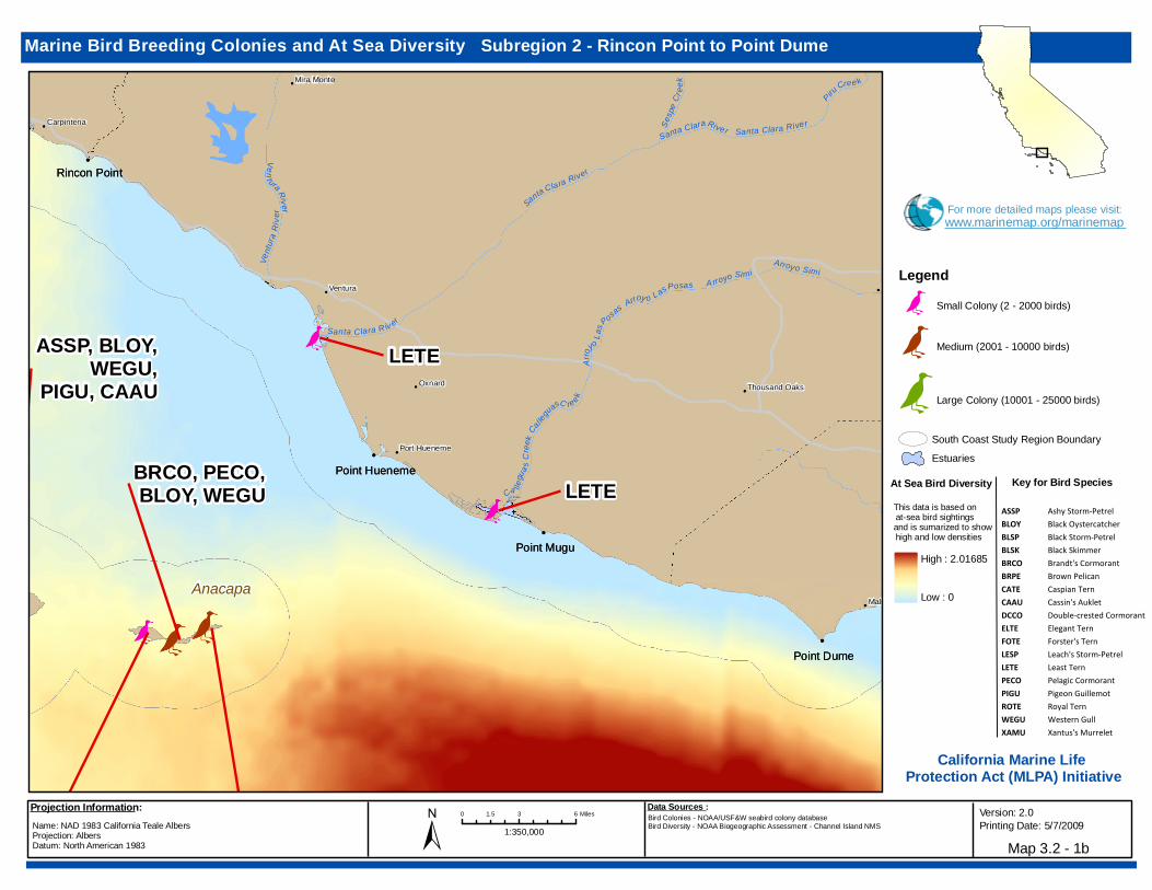
Data Sources: California Department of Fish and GameAnacapa
LETE
LETE
BRPE, DCCO,BLOY,
WEGU, PIGU
BRCO, PECO,BLOY, WEGU
BLOY,WEGU,XAMU
ASSP, BLOY,WEGU,
PIGU, CAAUWEGU,
PIGU
Vent ura Riv er
Arroy o Las Posas
Santa Clara River
Arroyo Simi
Calleg
uas C re ek
Santa Clara R iv er
A rroyo Sim i
Arroy
o Las P
osas
Santa Clara River
Ca llegua
s Cree
k
Sesp
e Cr e
ek
Piru Cree k
Ventu
ra Ri
ver Santa Clara River
Ventura Simi Valley
Port Hueneme
Mira Monte
Carpinteria
Malibu
Thousand OaksOxnard
Rincon Point
Point Mugu
Point Dume
Point Hueneme
Point Dume
Point Hueneme
Point Mugu
Rincon Point
Simi Valley
Mira Monte
Carpinteria
Ventura
Oxnard Thousand Oaks
Malibu
Port Hueneme
Name: NAD 1983 California Teale Albers Projection: Albers Datum: North American 1983
1:350,000±0 3 61.5 Miles Bird Colonies - NOAA/USF&W seabird colony database
Bird Diversity - NOAA Biogeographic Assessment - Channel Island NMS
Projection Information: Data Sources :
Marine Bird Breeding Colonies and At Sea Diversity Subregion 2 - Rincon Point to Point Dume
Map 3.2 - 1b
Version: 2.0Printing Date: 5/7/2009
Legend
JSmall Colony (2 - 2000 birds)
JMedium (2001 - 10000 birds)
JLarge Colony (10001 - 25000 birds)
South Coast Study Region BoundaryEstuaries
This data is based on at-sea bird sightings and is sumarized to show high and low densities
At Sea Bird Diversity
High : 2.01685
Low : 0
Key for Bird Species
ASSP Ashy Storm-PetrelBLOY Black OystercatcherBLSP Black Storm-PetrelBLSK Black SkimmerBRCO Brandt's CormorantBRPE Brown PelicanCATE Caspian TernCAAU Cassin's AukletDCCO Double-crested CormorantELTE Elegant TernFOTE Forster's TernLESP Leach's Storm-PetrelLETE Least TernPECO Pelagic CormorantPIGU Pigeon GuillemotROTE Royal TernWEGU Western GullXAMU Xantus's Murrelet
California Marine Life Protection Act (MLPA) Initiative
For more detailed maps please visit:www.marinemap.org/marinemap

Data Sources: California Department of Fish and Game
Santa Catalina
LETE
LETELETE
CATE, ELTE,FOTE,
LETE, BLSK
WEGU,XAMU
ASSP, BLSP, BRPE, DCCO, BRCO, PECO, BLOY, WEGU, PIGU, XAMU, CAAU
WEGU
LETE
LETE
LETE
M alib u Cre ek
L os
Angeles River
San Gabriel Rive r
Santa
A na R
iver
Ma libu C reek
Los A
ngeles R iver
San Ga
briel
River
Huntington Beach
Long Beach
Palos Verdes Estates
Hermosa Beach
Fullerton
Inglewood
Malibu Santa Monica
Los Angeles
Palos Verdes Point
Point Dume
Huntington Beach
Long Beach
Palos Verdes Estates
Hermosa Beach
Fullerton
Inglewood
Malibu Santa Monica
Palos Verdes Point
Point Dume
Los Angeles
Name: NAD 1983 California Teale Albers Projection: Albers Datum: North American 1983
1:400,000±0 3 61.5 Miles Bird Colonies - NOAA/USF&W seabird colony database
Bird Diversity - NOAA Biogeographic Assessment - Channel Island NMS
Projection Information: Data Sources :
Marine Bird Breeding Colonies and At Sea Diversity Subregion 3 - Point Dume to Newport Beach
Map 3.2 - 1c
Version: 2.0Printing Date: 5/7/2009
Legend
JSmall Colony (2 - 2000 birds)
JMedium (2001 - 10000 birds)
JLarge Colony (10001 - 25000 birds)
South Coast Study Region BoundaryEstuaries
This data is based on at-sea bird sightings and is sumarized to show high and low densities
At Sea Bird Diversity
High : 2.01685
Low : 0
Key for Bird Species
ASSP Ashy Storm-PetrelBLOY Black OystercatcherBLSP Black Storm-PetrelBLSK Black SkimmerBRCO Brandt's CormorantBRPE Brown PelicanCATE Caspian TernCAAU Cassin's AukletDCCO Double-crested CormorantELTE Elegant TernFOTE Forster's TernLESP Leach's Storm-PetrelLETE Least TernPECO Pelagic CormorantPIGU Pigeon GuillemotROTE Royal TernWEGU Western GullXAMU Xantus's Murrelet
California Marine Life Protection Act (MLPA) Initiative
For more detailed maps please visit:www.marinemap.org/marinemap
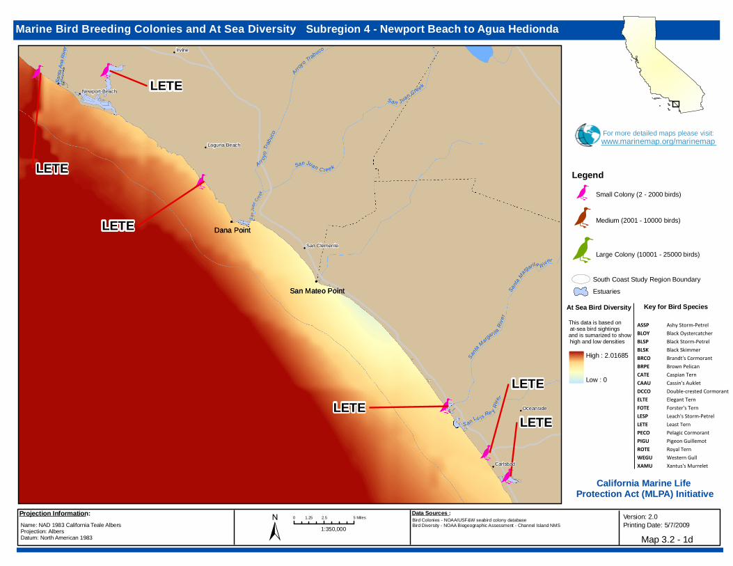
Data Sources: California Department of Fish and Game
LETELETE
CATE, ELTE,FOTE,
LETE, BLSK
LETE
LETE
LETELETE
LETE
LETE
LETE
LETE
S an J
uan C re ek
Santa
A na R
iv er
Ar r oyo T
r abuc
o
S an ta M argar i ta R iv
e r
S a n Juan C ree kS a n Lu is Re y Riv
er
A rroyo Trab uco
Sa nta Ma rgarita R iver
San Jua n C ree k
Irvine
Oceanside
Newport Beach
Laguna Beach
San Clemente
Carlsbad
Dana Point
San Mateo Point
Dana Point
San Mateo Point
Irvine
Oceanside
Newport Beach
Laguna Beach
San Clemente
Carlsbad
Name: NAD 1983 California Teale Albers Projection: Albers Datum: North American 1983
1:350,000±0 2.5 51.25 Miles Bird Colonies - NOAA/USF&W seabird colony database
Bird Diversity - NOAA Biogeographic Assessment - Channel Island NMS
Projection Information: Data Sources :
Marine Bird Breeding Colonies and At Sea Diversity Subregion 4 - Newport Beach to Agua Hedionda
Map 3.2 - 1d
Version: 2.0Printing Date: 5/7/2009
Legend
JSmall Colony (2 - 2000 birds)
JMedium (2001 - 10000 birds)
JLarge Colony (10001 - 25000 birds)
South Coast Study Region BoundaryEstuaries
This data is based on at-sea bird sightings and is sumarized to show high and low densities
At Sea Bird Diversity
High : 2.01685
Low : 0
Key for Bird Species
ASSP Ashy Storm-PetrelBLOY Black OystercatcherBLSP Black Storm-PetrelBLSK Black SkimmerBRCO Brandt's CormorantBRPE Brown PelicanCATE Caspian TernCAAU Cassin's AukletDCCO Double-crested CormorantELTE Elegant TernFOTE Forster's TernLESP Leach's Storm-PetrelLETE Least TernPECO Pelagic CormorantPIGU Pigeon GuillemotROTE Royal TernWEGU Western GullXAMU Xantus's Murrelet
California Marine Life Protection Act (MLPA) Initiative
For more detailed maps please visit:www.marinemap.org/marinemap


![Tincion Gram y Morfologia Bacteriana LESP [PQCMAOG]](https://static.fdocuments.net/doc/165x107/5571f19949795947648b641d/tincion-gram-y-morfologia-bacteriana-lesp-pqcmaog.jpg)