RUSUMO FALLS HYDROELECTRIC PROJECT DAM & POWERPLANT...
28
RUSUMO FALLS HYDROELECTRIC PROJECT – DAM & POWERPLANT COMPONENT ENVIRONMENTAL AND SOCIAL IMPACT ASSESSMENT (ESIA) NON-TECHNICAL SUMMARY DRAFT FINAL REPORT - REVISION 1 ARTELIA EAU & ENVIRONNEMENT ECHIROLLES 6, Rue de Lorraine 38130 Echirolles, France Tel.: +33 (0)4 76 33 40 00 Fax: +33 (0)4 76 33 43 32 NILE BASIN INITIATIVE (NBI) / NILE EQUATORIAL LAKES SUBSIDIARY ACTION PROGRAM (NELSAP) DATE: FEB. 2013 REF: 1770050 Coteba & Sogreah, same team, enhanced expertise Public Disclosure Authorized Public Disclosure Authorized Public Disclosure Authorized Public Disclosure Authorized Public Disclosure Authorized Public Disclosure Authorized Public Disclosure Authorized Public Disclosure Authorized
Transcript of RUSUMO FALLS HYDROELECTRIC PROJECT DAM & POWERPLANT...

RUSUMO FALLS HYDROELECTRIC
PROJECT – DAM & POWERPLANT
COMPONENT
ENVIRONMENTAL AND SOCI AL IMP ACT ASSESSMENT (ESI A)
NON-TECHNICAL SUMMARY
DRAFT FINAL REPORT - REVISION 1
ARTELIA EAU & ENVIRONNEMENT
ECHIROLLES
6, Rue de Lorraine 38130 Echirolles, France
Tel.: +33 (0)4 76 33 40 00 Fax: +33 (0)4 76 33 43 32
NILE BASIN INITIATIVE (NBI) / NILE EQUATORIAL LAKES SUBSIDIARY ACTION PROGRAM (NELSAP)
DATE: FEB. 2013 REF: 1770050 Coteba & Sogreah, same team, enhanced expertise
Pub
lic D
iscl
osur
e A
utho
rized
Pub
lic D
iscl
osur
e A
utho
rized
Pub
lic D
iscl
osur
e A
utho
rized
Pub
lic D
iscl
osur
e A
utho
rized
Pub
lic D
iscl
osur
e A
utho
rized
Pub
lic D
iscl
osur
e A
utho
rized
Pub
lic D
iscl
osur
e A
utho
rized
Pub
lic D
iscl
osur
e A
utho
rized
wb231615
Typewritten Text
E4144v2
RUSUMO FALLS HYDROELECTRIC PROJECT
DAM & POWERPLANT COMPONENT
E N V I R O N ME N TA L A N D SO C I A L I M P A CT A SS ES S ME N T ( ES IA ) : N O N - TE C H N I C AL S UM M AR Y
/ 1770050 / FEB 2013 DRAFT FINAL REPORT – REVISION 1 1 | P a g e
ABSTRACT
This Environmental and Social Impact Assessment (ESIA) has been prepared by Artelia Eau &
Environnement on behalf of the Nile Equatorial Lakes Subsidiary Action Program (NELSAP), which
has the responsibility of managing the Rusumo Falls hydroelectric Project;
The project is a Category A project with respect to the World Bank’s OP/BP 4.01 for Environmental
Assessment, and encompasses the construction and operation of a concrete gravity dam spanning
across the Kagera River upstream of the Rusumo Falls. The hydroelectric scheme will operate as a
Run-of-River scheme and there will be no water storage reservoir created upstream of the dam.
However the scheme will modify the seasonal flooding regime of the upstream marshland. Also the
Kagera River flowing over the Rusumo Falls and along a 500 metre stretch of river downstream from
the dam will be bypassed. There will be no changes in hydrology further downstream.
This ESIA addresses the environmental and social impacts associated with the construction,
operation and decommissioning of the structures and facilities. The project area of influence
encompasses areas in Rwanda (Kirehe district of the Eastern Province) and Tanzania (Ngara district
of the Kagera region). However, there are no predicted impacts in Burundi.
The ESIA has involved modelling of the changes in hydrology of the Kagera and Ruvubu Rivers in
order to predict impact on the natural and socioeconomic environment. Bibliographic review, interview
with national experts and field surveys have been carried out to determine the environmental
sensitivity of project affected areas.
A Resettlement Action Plan (RAP), including a Local Area Development Plan has been prepared in
parallel to ESIA as is issued as a separate stand-alone document.
The findings of this ESIA do not result in recommendations for changing the design of the structures
and facilities.
RUSUMO FALLS HYDROELECTRIC PROJECT
DAM & POWERPLANT COMPONENT
E N V I R O N ME N TA L A N D SO C I A L I M P A CT A SS ES S ME N T ( ES IA ) : N O N - TE C H N I C AL S UM M AR Y
/ 1770050 / FEB 2013 DRAFT FINAL REPORT – REVISION 1 2 | P a g e
NON-TECHNICAL SUMMARY
INTRODUCTION
Background: Lack of electricity is a key constraint hampering development in Burundi, Rwanda, and
Tanzania. The lack of access to reliable power supply services hampers growth potential, contributes
to the poverty and isolation of rural population. The Rusumo Falls Hydropower Project will play a role
in increasing regional power generation and to help meet national demand. The Project will enhance
economic and social development in the region.
Purpose of the Report: The Environmental and Social Impact Assessment (ESIA) and Resettlement
Action Plan (RAP) have been prepared to assess the environmental and social impacts associated
with the Run-of-River (RoR) Development Scheme of the dam and powerplant component of the
Rusumo Falls Hydroelectric Project1. The study has been prepared in order to comply with the
Safeguard Policies of the World Bank, which is the main International Funding Agency for the project,
and the environment regulatory requirements of Rwanda and Tanzania, which are the countries
affected by the Project.
Project Developer and the Role of the Nile Basin Initiative and NELSAP: The Project is a joint
development undertaking by the Governments of Burundi, Rwanda and Tanzania. The project
preparation management arrangements consist, at the regional level, of (i) a Council of Ministers in
charge of electricity in the three countries; (ii) a Project Implementation Committee (PIC) consisting of
the Managing Director/Director General of the Electricity Utility, Director General/
Commissioner/Director of Energy in each country, (iii) a Project Manager at the NELSAP Coordination
Unit (NELSAP-CU), and (iv) a Technical Advisory Committee. The aim of the Nile Basin Initiative
(NBI) is combating poverty and promoting socioeconomic development in the ten Nile riparian
countries. The NELSAP is part of the NBI. The immediate objectives of the NELSAP are to increase
the supply of electric power networks in the region and to guide policy makers in the development
process in the most efficient, economical and environmentally friendly way. Prior to the start of the
implementation phase, a Share Holders' Agreements (SHA) and an Implementation Agreement (IA)
will be established between the participating countries. Once the project is in the implementation
phase, the role of project owner will be delegated to a Special Purpose Vehicle Project Company
(SPV). The SPV shall be responsible for all aspects of project management, including those
associated with its environmental and social issues. The SPV will be assisted by an Owner’s Engineer
(OE) who will assist and collaborate with the the SPV, carry out the detailed design of the structures
and facilities, prepare tender documents and supervise the work of the construction contractor.
Financing of the Project: The Governments of Burundi, Rwanda and Tanzania will receive financial
support from various donors for the preparation of the Project. A Joint Project Development
Agreement was signed by the Ministers of Energy of the three countries in March 2006, reconfirming
their commitment to jointly develop the Project. A tripartite agreement was signed by the three
countries on the 16th February 2012.
Current stage of Project Preparation: The feasibility study for the dam and powerplant has been
completed and a call for tender has been launched for the owner’s engineer. The owner’s engineer
1 The assessment of the Transmission Lines component is not included in the report.
RUSUMO FALLS HYDROELECTRIC PROJECT
DAM & POWERPLANT COMPONENT
E N V I R O N ME N TA L A N D SO C I A L I M P A CT A SS ES S ME N T ( ES IA ) : N O N - TE C H N I C AL S UM M AR Y
/ 1770050 / FEB 2013 DRAFT FINAL REPORT – REVISION 1 3 | P a g e
will be responsible for preparing the detailed dam and powerplant design and preparation of tender
documents for the construction engineer.
SCOPE AND EXTENT OF THE ESIA
The ESIA was carried out during the period September 2012 – January 2013 and represents a
magnitude of effort of 24 man-months (12 man-months for international staff and 12 man-months for
local consultants. The work comprised adjusting, building upon and completing the ESIA for the Full
and Intermediate Development Schemes and included carrying out (i) additional environmental
expertise on the flora and fauna of the project’s area of influence, (ii) additional consultations with the
Project Affected People and (iii) additional hydraulic modelling to build upon previous work to
determine the impact of the physical presence of the dam on hydrology and changes to natural
seasonal variations in marshland flooding.
Contents of the ESIA
The ESIA report comprises 7 chapters as follows:
Chapter 1 – Introduction: The chapter provides information on the purpose of the report, the project developer. It provides an
overview of the project, the scope and extent of the ESIA and a summary of the ESIA report.
Chapter 2 – Legal and Administrative Framework: This chapter provides a summary description of the relevant key
administrative bodies and legislation and regulations relating the ESIA, environmental protection and resettlement in both
Rwanda and Tanzania. The international conventions and standards that are applicable are provided as are the safeguard
policies of the World Bank.
Chapter 3 – Project Description: This chapter provides a description of the structures and operating modes based on the
feasibility study for the Intermediate Development Scheme carried out by SLII in 2011/12. The structures and activities for the
RoR scheme will be much the same as for Intermediate Development Scheme.
Chapter 4 – Baseline Situation: The description of the environmental and social baseline situation comprises information
reported in previous studies and which comprises bibliographic data; findings of environmental field surveys carried out from
November 2007 to June 2008 and completed in January 2012 and February 2013, and social surveys conducted in 2011 and
2012. The previous studies have been complemented by the findings of environmental expertise and public consultations
carried out by Artelia during the period October 2012 –January 2013.
Chapter 5 – Alternatives: The alternatives which are addressed in this chapter comprise: (i) no project alternative, (ii)
alternative location, (iii) alternative design and (iv) alternative technology. A comparison of impacts for the Full, Intermediate
and Run-of-River Development Schemes is provided and a justification of the selection of the preferred alternative.
Chapter 6 – Assessment of Impacts and Mitigation Measures: The assessment and mitigation measures address the
impacts of construction, operation and deconstruction on the natural and human environment. The main issues related to the
construction phase include (i) the socioeconomic impacts associated with resettlement of households that are located in areas
needed for construction activities. These impacts are managed through the Resettlement Action Plan, which is issued as a
separate document and (ii) impacts on hydrology and consequently on flora and fauna associated with the diversion of the river
through a diversion channel thus bypassing the Rusumo Falls and a section of the river downstream. These impacts are
unavoidable. Other impacts on flora, fauna, air quality and water quality can be anticipated during construction and these will be
controlled through a number of environmental management plans.
Chapter 7 – Environmental and Social Management Plan: This chapter provides a summary of the environmental and social
impacts, the objectives of environmental and social management plan, general and specific management plans, the roles and
responsibilities for implementation and the implementation schedule and costs.
RUSUMO FALLS HYDROELECTRIC PROJECT
DAM & POWERPLANT COMPONENT
E N V I R O N ME N TA L A N D SO C I A L I M P A CT A SS ES S ME N T ( ES IA ) : N O N - TE C H N I C AL S UM M AR Y
/ 1770050 / FEB 2013 DRAFT FINAL REPORT – REVISION 1 4 | P a g e
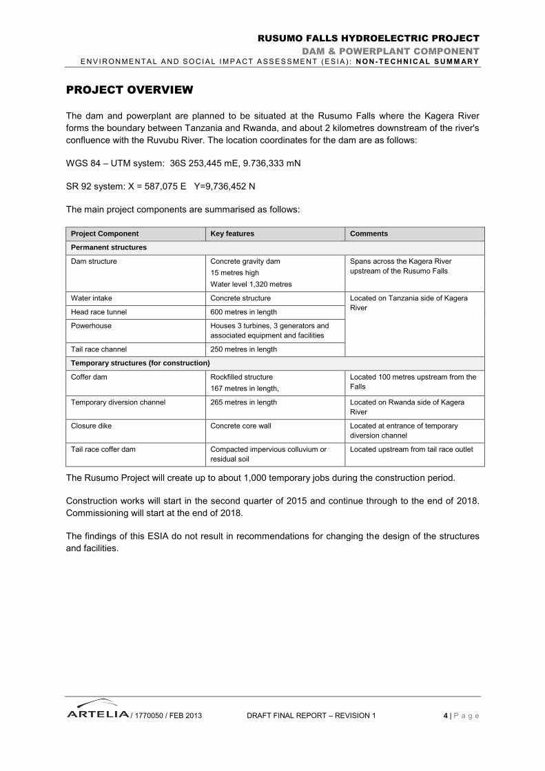
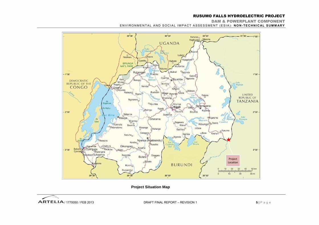
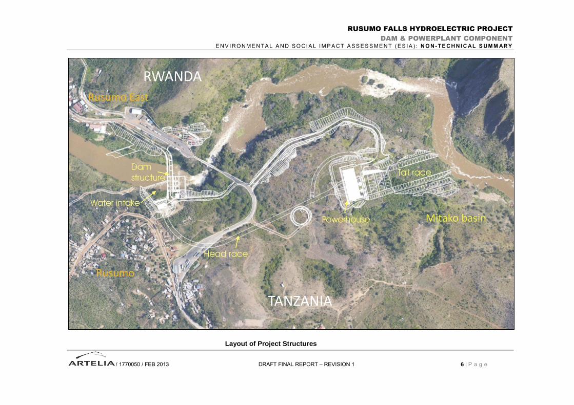
PROJECT OVERVIEW
The dam and powerplant are planned to be situated at the Rusumo Falls where the Kagera River
forms the boundary between Tanzania and Rwanda, and about 2 kilometres downstream of the river's
confluence with the Ruvubu River. The location coordinates for the dam are as follows:
WGS 84 – UTM system: 36S 253,445 mE, 9.736,333 mN
SR 92 system: X = 587,075 E Y=9,736,452 N
The main project components are summarised as follows:
Project Component Key features Comments
Permanent structures
Dam structure Concrete gravity dam
15 metres high
Water level 1,320 metres
Spans across the Kagera River
upstream of the Rusumo Falls
Water intake Concrete structure Located on Tanzania side of Kagera
River Head race tunnel 600 metres in length
Powerhouse Houses 3 turbines, 3 generators and
associated equipment and facilities
Tail race channel 250 metres in length
Temporary structures (for construction)
Coffer dam Rockfilled structure
167 metres in length,
Located 100 metres upstream from the
Falls
Temporary diversion channel 265 metres in length Located on Rwanda side of Kagera
River
Closure dike Concrete core wall Located at entrance of temporary
diversion channel
Tail race coffer dam Compacted impervious colluvium or
residual soil
Located upstream from tail race outlet
The Rusumo Project will create up to about 1,000 temporary jobs during the construction period.
Construction works will start in the second quarter of 2015 and continue through to the end of 2018.
Commissioning will start at the end of 2018.
The findings of this ESIA do not result in recommendations for changing the design of the structures
and facilities.
RUSUMO FALLS HYDROELECTRIC PROJECT
DAM & POWERPLANT COMPONENT
E N V I R O N ME N TA L A N D SO C I A L I M P A CT A SS ES S ME N T ( ES IA ) : N O N - TE C H N I C AL S UM M AR Y
/ 1770050 / FEB 2013 DRAFT FINAL REPORT – REVISION 1 5 | P a g e
Project Situation Map
Project Location
RUSUMO FALLS HYDROELECTRIC PROJECT
DAM & POWERPLANT COMPONENT
E N V I R O N ME N TA L A N D SO C I A L I M P A CT A SS ES S ME N T ( ES IA ) : N O N - TE C H N I C AL S UM M AR Y
/ 1770050 / FEB 2013 DRAFT FINAL REPORT – REVISION 1 6 | P a g e
Layout of Project Structures
RUSUMO FALLS HYDROELECTRIC PROJECT
DAM & POWERPLANT COMPONENT
E N V I R O N ME N TA L A N D SO C I A L I M P A CT A SS ES S ME N T ( ES IA ) : N O N - TE C H N I C AL S UM M AR Y
/ 1770050 / FEB 2013 DRAFT FINAL REPORT – REVISION 1 7 | P a g e
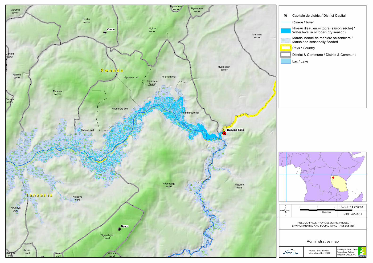
PROJECT AREA OF INFLUENCE AND ADMINISTRATIVE BOUNDERIES
The Project area of influence and the administrative boundaries are illustrated on the map overleaf.
In Rwanda, the project area of influence lies within the Kirehe district of the Eastern Province.
In Tanzania, it is the Ngara district of the Kagera region that is concerned by the project.
No detectable impacts are expected in Burundi.
Construction Activities
In Rwanda: The construction activities will affect:
The villages of Nyakwisi and Rusumo West, which are in the Nyankurazo cell, Kigarama Sector
The village of Rusumo East, which is in the Nyamugali sector
Tanzania: The construction activities will affect the village of Rusumo, which is situated in the Rusumo
Ward.
Operation Phase
The operation phase affects the marshlands upstream of the dam and a 500 metres stretch of river
immediately downstream from the dam.
In Rwanda, the affected marshland upstream from the dam is entirely located in Kigarama sector and
the concerned cells comprise: Nyankurazo, Kiremera, Kigalama, Nyakerera and Cyanya. No
detectable impacts in the Musaza sector (further upstream from Kigarama) are expected, though the
rate of seasonal changes in water level may be slightly modified in this area. The downstream
section of the river which is affected is in the Nyamugali sector
In Tanzania, the affected marshlands of the Kagera and Ruvubu valleys upstream from the dam are
entirely located in the Ngara district. Villages along the right bank of the Kagera marshland and left
bank of the Ruvubu marshland are located in the Nyamiyaga Ward. Villages along the right bank of
the Ruvubu valley are located in the Rusumo Ward.
!P
!P
!HCyanya cell
Kiremera cell
Nyakerera cell
Kiyalama cell
Nyankurazo cell
Kigaramasector
Musazasector
Nyamugarisector
Gatoresector
Kiginasector
Kirehesector
Mahamasector
Muramasector
Nyarubuyesector
Gaharasector
Nyarubuyesector
Gaharasector
Rusumoward
Nyamiyagaward
Ntobeyeward
Kirushyaward
Ngara Mjiniward
Kanaziward Kibimba
wardKanaziward
Mugomaward
Kagera
Ruvubu
Ngara
Kirehe
Rusumo Falls
R w a n d aR w a n d a
T a n z a n i aT a n z a n i a
2 0 2 41
Kilometres©Report n° 1 77 0050
Date : Jan. 2013
!(
Administrative map
RUSUMO FALLS HYDROELECTRIC PROJECTENVIRONMENTAL AND SOCIAL IMPACT ASSESSMENT
Nile Equatorial Lakes Subsidiary Action Program (NELSAP)
!P Capitale de district / District CapitalRivière / RiverNiveau d'eau en octobre (saison sèche) / Water level in october (dry season)Marais inondé de manière saisonnière / Marshland seasonally floodedPays / CountryDistrict & Commune / District & CommuneLac / Lake
source : SNC Lavalin International Inc, 2012
RUSUMO FALLS HYDROELECTRIC PROJECT
DAM & POWERPLANT COMPONENT
E N V I R O N ME N TA L A N D SO C I A L I M P A CT A SS ES S ME N T ( ES IA ) : N O N - TE C H N I C AL S UM M AR Y
/ 1770050 / FEB 2013 DRAFT FINAL REPORT – REVISION 1 9 | P a g e
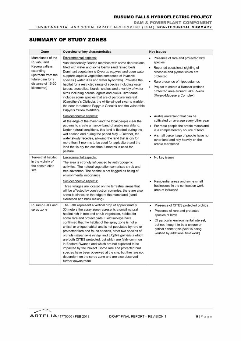
SUMMARY OF STUDY ZONES
Zone Overview of key characteristics Key Issues
Marshlands of the
Ruvubu and
Kagera valleys
extending
upstream from the
future dam for a
distance of 15-20
kilometres)
Environmental aspects:
Vast seasonally flooded marshes with some depressions
filled with water and some loamy sand raised beds.
Dominant vegetation is Cyperus papyrus and open water
supports aquatic vegetation composed of invasive
species ( water lilies and water hyacinths). Provides the
habitat for a restricted range of species including water
turtles, crocodiles, lizards, snakes and a variety of water
birds including herons, egrets and ducks. Bird fauna
includes some species that are of particular interest
(Carruthers’s Cisticola, the white-winged swamp warbler,
the near threatened Papyrus Gonolek and the vulnerable
Papyrus Yellow Warbler).
Presence of rare and protected bird
species
Reported occasional sighting of
crocodile and python which are
protected
Rare presence of hippopotamus
Project to create a Ramsar wetland
protected area around Lake Rweru
(Rweru-Mugesera Complex)
Socioeconomic aspects:
At the edge of the marshland the local people clear the
papyrus to create a narrow band of arable marshland.
Under natural conditions, this land is flooded during the
wet season and during the period May – October, the
water slowly recedes, allowing the land that is dry for
more than 3 months to be used for agriculture and the
land that is dry for less than 3 months is used for
pasture.
Arable marshland that can be
cultivated on average every other year
For most people the arable marshland
is a complementary source of food
A small percentage of people have no
other land and rely heavily on the
arable marshland
Terrestrial habitat
in the vicinity of
the construction
site
Environmental aspects:
The area is strongly influenced by anthropogenic
activities. The natural vegetation comprises shrub and
tree savannah. The habitat is not flagged as being of
environmental importance
No key issues
Socioeconomic aspects:
Three villages are located on the terrestrial areas that
will be affected by construction comprise, there are also
some business on the edge of the marshland (sand
extraction and brick making)
Residential areas and some small
businesses in the contraction work
area of influence
Rusumo Falls and
spray zone
The Falls represent a vertical drop of approximately
30 meters the spray zone represents a small natural
habitat rich in tree and shrub vegetation, habitat for
some rare and protect birds. Field surveys have
confirmed that the habitat of the spray zone is not a
critical or unique habitat and is not populated by rare or
protected flora and fauna species, other two species of
orchids (Impantiens irvingii and Elophia guinensis which
are both CITES protected, but which are fairly common
in Eastern Rwanda and which are not expected to be
impacted by the Project. Some rare and protected bird
species have been observed at the site, but they are not
dependent on the spray zone and are also observed
further downstream
Presence of CITES protected orchids
Presence of rare and protected
species of birds
Of particular environmental interest,
but not thought to be a unique or
critical habitat (this point is being
verified by additional field work)

RUSUMO FALLS HYDROELECTRIC PROJECT
DAM & POWERPLANT COMPONENT
E N V I R O N ME N TA L A N D SO C I A L I M P A CT A SS ES S ME N T ( ES IA ) : N O N - TE C H N I C AL S UM M AR Y
/ 1770050 / FEB 2013 DRAFT FINAL REPORT – REVISION 1 10 | P a g e
Zone Overview of key characteristics Key Issues
Downstream
rapids (500 metres
in length)
Environmental aspects:
The rapids stretches downstream from the Falls for a
distance of 800 metres. The principal land vegetation are
shrubs and tree savannahs. Local people report that
hippopotamus and Nile Crocodile from the Akagera
National Park are sometimes observed. This stretch of
river is important for fish and the fast moving waters are
probably a habitat for fish spawning. A specific survey of
of the fish in this zone was carried out in January 2012
and no protected or rare fish species were observed.
Possible important area for fish life;
Occasional presence of Crocodile,
hippopotamus (from Akagera National
Park)
Socioeconomic aspects:
The area is rich in fish and fishing activities take place in
area where local fishing cooperative is operating.
Fishing activities by local fishermen
Zone extending
further
downstream from
the rapids
The zone is not expected to be affected by the project
The zone is characterized by marshes and a complex
system of lakes located in the Akagara National Park
(60 kilometres downstream).
Presence of protected areas and game
reserves 60 km downstream

RUSUMO FALLS HYDROELECTRIC PROJECT
DAM & POWERPLANT COMPONENT
E N V I R O N ME N TA L A N D SO C I A L I M P A CT A SS ES S ME N T ( ES IA ) : N O N - TE C H N I C AL S UM M AR Y
/ 1770050 / FEB 2013 DRAFT FINAL REPORT – REVISON 1 11 | P a g e
General View of Marshland
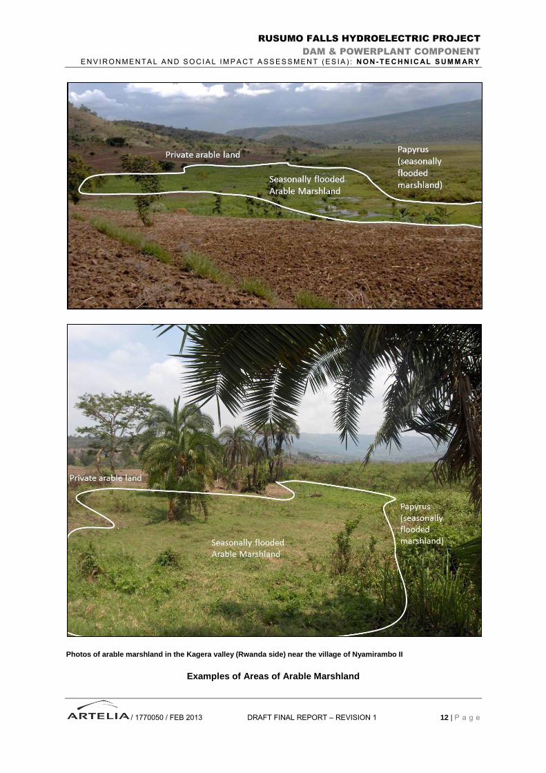
General View of valley with areas of marshland upstrealm from the future dam, filling most of the bottom of the valley, arable marshland bordering the papyrus marshland and intermediate (private arable land) set back at a slightly higer elevation.
RUSUMO FALLS HYDROELECTRIC PROJECT
DAM & POWERPLANT COMPONENT
E N V I R O N ME N TA L A N D SO C I A L I M P A CT A SS ES S ME N T ( ES IA ) : N O N - TE C H N I C AL S UM M AR Y
/ 1770050 / FEB 2013 DRAFT FINAL REPORT – REVISION 1 12 | P a g e
Photos of arable marshland in the Kagera valley (Rwanda side) near the village of Nyamirambo II
Examples of Areas of Arable Marshland
RUSUMO FALLS HYDROELECTRIC PROJECT
DAM & POWERPLANT COMPONENT
E N V I R O N ME N TA L A N D SO C I A L I M P A CT A SS ES S ME N T ( ES IA ) : N O N - TE C H N I C AL S UM M AR Y
/ 1770050 / FEB 2013 DRAFT FINAL REPORT – REVISION 1 13 | P a g e
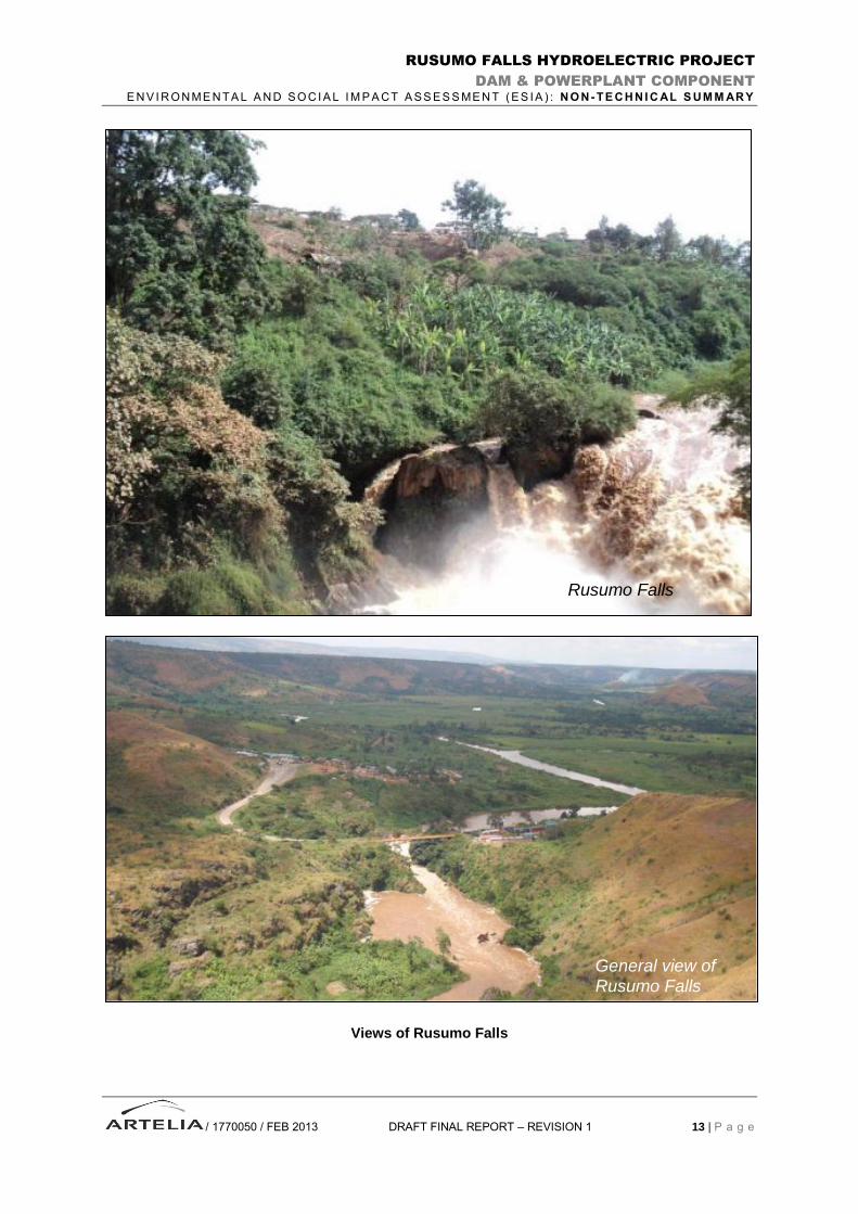
Views of Rusumo Falls
Rusumo Falls
General view of Rusumo Falls
RUSUMO FALLS HYDROELECTRIC PROJECT
DAM & POWERPLANT COMPONENT
E N V I R O N ME N TA L A N D SO C I A L I M P A CT A SS ES S ME N T ( ES IA ) : N O N - TE C H N I C AL S UM M AR Y
/ 1770050 / FEB 2013 DRAFT FINAL REPORT – REVISION 1 14 | P a g e
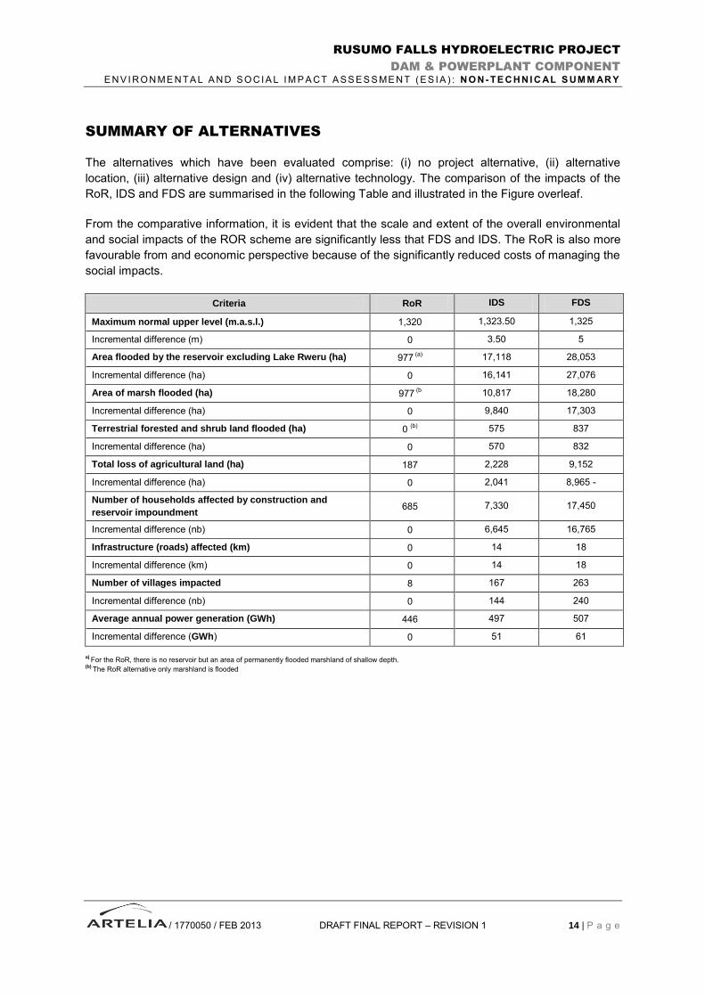
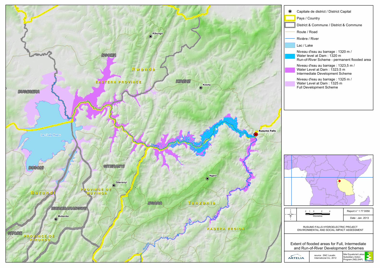
SUMMARY OF ALTERNATIVES
The alternatives which have been evaluated comprise: (i) no project alternative, (ii) alternative
location, (iii) alternative design and (iv) alternative technology. The comparison of the impacts of the
RoR, IDS and FDS are summarised in the following Table and illustrated in the Figure overleaf.
From the comparative information, it is evident that the scale and extent of the overall environmental
and social impacts of the ROR scheme are significantly less that FDS and IDS. The RoR is also more
favourable from and economic perspective because of the significantly reduced costs of managing the
social impacts.
Criteria RoR IDS FDS
Maximum normal upper level (m.a.s.l.) 1,320 1,323.50 1,325
Incremental difference (m) 0 3.50 5
Area flooded by the reservoir excluding Lake Rweru (ha) 977 (a)
17,118 28,053
Incremental difference (ha) 0 16,141 27,076
Area of marsh flooded (ha) 977 (b
10,817 18,280
Incremental difference (ha) 0 9,840 17,303
Terrestrial forested and shrub land flooded (ha) 0 (b)
575 837
Incremental difference (ha) 0 570 832
Total loss of agricultural land (ha) 187 2,228 9,152
Incremental difference (ha) 0 2,041 8,965 -
Number of households affected by construction and
reservoir impoundment 685 7,330 17,450
Incremental difference (nb) 0 6,645 16,765
Infrastructure (roads) affected (km) 0 14 18
Incremental difference (km) 0 14 18
Number of villages impacted 8 167 263
Incremental difference (nb) 0 144 240
Average annual power generation (GWh) 446 497 507
Incremental difference (GWh) 0 51 61
a) For the RoR, there is no reservoir but an area of permanently flooded marshland of shallow depth.
(b) The RoR alternative only marshland is flooded
!P
!P
!P
!P
!P
!P
!P
!H
E A S T E R N P R O V I N C EE A S T E R N P R O V I N C E
K A G E R A R E G I O NK A G E R A R E G I O N
P R O V I N C E D E P R O V I N C E D E M U Y I N G AM U Y I N G A
P R O V I N C E D E P R O V I N C E D E K I R U N D OK I R U N D O
KageraRu
vubu
Ngara
Kirehe
Kibungo
Mukenke
Giteranyi
Rusumo Falls
R w a n d aR w a n d a
T a n z a n i aT a n z a n i aB u r u n d iB u r u n d i
Lac / Lake Rweru
NGARA
KIREHE
NGOMA
BUSONI GITERANYI
BUGESERA
GITOBE
BWAMBARANGWE2 0 2 41
Kilometres©Report n° 1 77 0050
Date : Jan. 2013
!(
Extent of flooded areas for Full, Intermediate and Run-of-River Development Schemes
RUSUMO FALLS HYDROELECTRIC PROJECTENVIRONMENTAL AND SOCIAL IMPACT ASSESSMENT
Nile Equatorial Lakes Subsidiary Action Program (NELSAP)
!P Capitale de district / District CapitalPays / CountryDistrict & Commune / District & CommuneRoute / RoadRivière / RiverLac / LakeNiveau d'eau au barrage : 1320 m / Water level at Dam : 1320 m Run-of-River Scheme - permanent flooded areaNiveau d'eau au barrage : 1323,5 m / Water Level at Dam : 1323.5 m Intermediate Development SchemeNiveau d'eau au barrage : 1325 m / Water Level at Dam : 1325 m Full Development Scheme
source : SNC Lavalin International Inc, 2012
RUSUMO FALLS HYDROELECTRIC PROJECT
DAM & POWERPLANT COMPONENT
E N V I R O N ME N TA L A N D SO C I A L I M P A CT A SS ES S ME N T ( ES IA ) : N O N - TE C H N I C AL S UM M AR Y
/ 1770050 / FEB 2013 DRAFT FINAL REPORT – REVISION 1 16 | P a g e
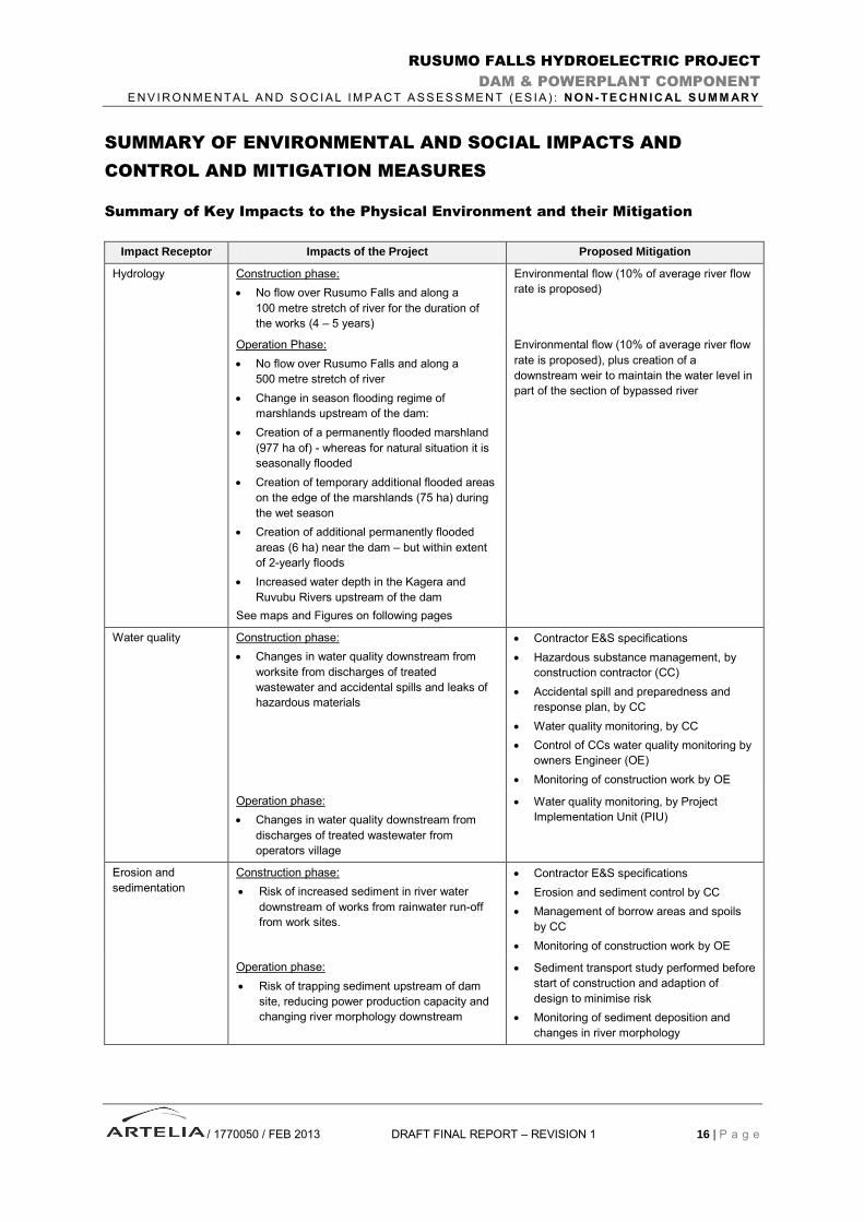
SUMMARY OF ENVIRONMENTAL AND SOCIAL IMPACTS AND
CONTROL AND MITIGATION MEASURES
Summary of Key Impacts to the Physical Environment and their Mitigation
Impact Receptor Impacts of the Project Proposed Mitigation
Hydrology Construction phase:
No flow over Rusumo Falls and along a
100 metre stretch of river for the duration of
the works (4 – 5 years)
Environmental flow (10% of average river flow
rate is proposed)
Operation Phase:
No flow over Rusumo Falls and along a
500 metre stretch of river
Change in season flooding regime of
marshlands upstream of the dam:
Creation of a permanently flooded marshland
(977 ha of) - whereas for natural situation it is
seasonally flooded
Creation of temporary additional flooded areas
on the edge of the marshlands (75 ha) during
the wet season
Creation of additional permanently flooded
areas (6 ha) near the dam – but within extent
of 2-yearly floods
Increased water depth in the Kagera and
Ruvubu Rivers upstream of the dam
See maps and Figures on following pages
Environmental flow (10% of average river flow
rate is proposed), plus creation of a
downstream weir to maintain the water level in
part of the section of bypassed river
Water quality Construction phase:
Changes in water quality downstream from
worksite from discharges of treated
wastewater and accidental spills and leaks of
hazardous materials
Contractor E&S specifications
Hazardous substance management, by
construction contractor (CC)
Accidental spill and preparedness and
response plan, by CC
Water quality monitoring, by CC
Control of CCs water quality monitoring by
owners Engineer (OE)
Monitoring of construction work by OE
Operation phase:
Changes in water quality downstream from
discharges of treated wastewater from
operators village
Water quality monitoring, by Project
Implementation Unit (PIU)
Erosion and
sedimentation
Construction phase:
Risk of increased sediment in river water
downstream of works from rainwater run-off
from work sites.
Contractor E&S specifications
Erosion and sediment control by CC
Management of borrow areas and spoils
by CC
Monitoring of construction work by OE
Operation phase:
Risk of trapping sediment upstream of dam
site, reducing power production capacity and
changing river morphology downstream
Sediment transport study performed before
start of construction and adaption of
design to minimise risk
Monitoring of sediment deposition and
changes in river morphology

RUSUMO FALLS HYDROELECTRIC PROJECT
DAM & POWERPLANT COMPONENT
E N V I R O N M E N T A L A N D S O C I A L I M P A C T A S S E S S M E N T ( E S I A )
/ 1770050 / FEB 2013 DRAFT FINAL REPORT – REVISON 1 17 | P a g e
Section of Kagera River Affected by Temporary Deviation Channel

RUSUMO FALLS HYDROELECTRIC PROJECT
DAM & POWERPLANT COMPONENT
E N V I R O N M E N T A L A N D S O C I A L I M P A C T A S S E S S M E N T ( E S I A )
/ 1770050 / FEB 2013 DRAFT FINAL REPORT – REVISON 1 18 | P a g e
Section of Kagera River Affected by Power Production
XWTANZANIA
RWANDA
Kagera
Ruvubu
Kivu
Kagali
Busoro
Kyenda
Kabuye RusumoGicuma
Kabuga
Gakoni
GatariKabeza
Ruhuha
Luhembe
Gwingwe
Kabigwa
Ntoboye
Gasenyi
Kigende
Kimeshu
Gahindu
MaremboKacyiru
Rwintuku
Gwintuku
MurukoliKanyosha
Kaguriro
Nyakwisi
Kumurenge
Nyamikono
Nyakiriba
Rwinyundo
Ryamukaza
Nyarutovu
Kabimba I
Nyarutojo
Nyakigera
Mukilelama
Songambele
Nyakahanga
Nyagahanga
Nyakabungo
Nyakariba I
Bweranka II
Nshungerezi
Rusumo WestRusumo East
Gasarabwayi
Mukatokatoke
Nyakariba II
Nyamirambo I
Nyamirambo II
1 0 1 20.5
Kilometres©Report n° 1 77 0050
Date : Jan. 2013
!(
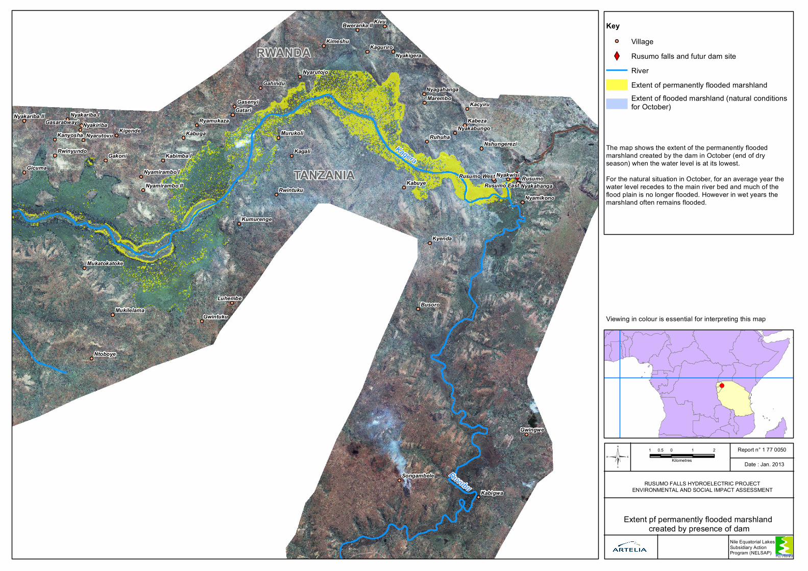
Extent pf permanently flooded marshland created by presence of dam
RUSUMO FALLS HYDROELECTRIC PROJECTENVIRONMENTAL AND SOCIAL IMPACT ASSESSMENT
Nile Equatorial Lakes Subsidiary Action Program (NELSAP)
KeyVillage
XW Rusumo falls and futur dam siteRiverExtent of permanently flooded marshlandExtent of flooded marshland (natural conditions for October)
The map shows the extent of the permanently flooded marshland created by the dam in October (end of dry season) when the water level is at its lowest.For the natural situation in October, for an average year the water level recedes to the main river bed and much of the flood plain is no longer flooded. However in wet years the marshland often remains flooded.
Viewing in colour is essential for interpreting this map
XWTANZANIA
RWANDA
Kagera
Ruvubu
Kivu
Kagali
Busoro
Kyenda
Kabuye RusumoGicuma
Kabuga
Gakoni
GatariKabeza
Ruhuha
Luhembe
Gwingwe
Kabigwa
Ntoboye
Gasenyi
Kigende
Kimeshu
Gahindu
MaremboKacyiru
Rwintuku
Gwintuku
MurukoliKanyosha
Kaguriro
Nyakwisi
Kumurenge
Nyamikono
Nyakiriba
Rwinyundo
Ryamukaza
Nyarutovu
Kabimba I
Nyarutojo
Nyakigera
Mukilelama
Songambele
Nyakahanga
Nyagahanga
Nyakabungo
Nyakariba I
Bweranka II
Nshungerezi
Rusumo WestRusumo East
Gasarabwayi
Mukatokatoke
Nyakariba II
Nyamirambo I
Nyamirambo II
1 0 1 20.5
Kilometres©Report n° 1 77 0050
Date : Jan. 2013
!(
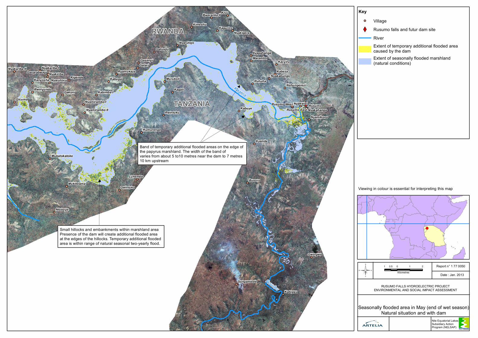
Seasonally flooded area in May (end of wet season)Natural situation and with dam
RUSUMO FALLS HYDROELECTRIC PROJECTENVIRONMENTAL AND SOCIAL IMPACT ASSESSMENT
Nile Equatorial Lakes Subsidiary Action Program (NELSAP)
KeyVillage
XW Rusumo falls and futur dam siteRiverExtent of temporary additional flooded area caused by the damExtent of seasonally flooded marshland (natural conditions)
Band of temporary additional flooded areas on the edge of the papyrus marshland. The width of the band of varies from about 5 to10 metres near the dam to 7 metres 10 km upstream
Small hillocks and embankments within marshland areaPresence of the dam will create additional flooded area at the edges of the hillocks. Temporary additional flooded area is within range of natural seasonal two-yearly flood.
Viewing in colour is essential for interpreting this map
RUSUMO FALLS HYDROELECTRIC PROJECT
DAM & POWERPLANT COMPONENT
E N V I R O N M E N T A L A N D S O C I A L I M P A C T A S S E S S M E N T ( E S I A )
/ 1770050 / FEB 2013 DRAFT FINAL REPORT – REVISION 1 21 | P a g e
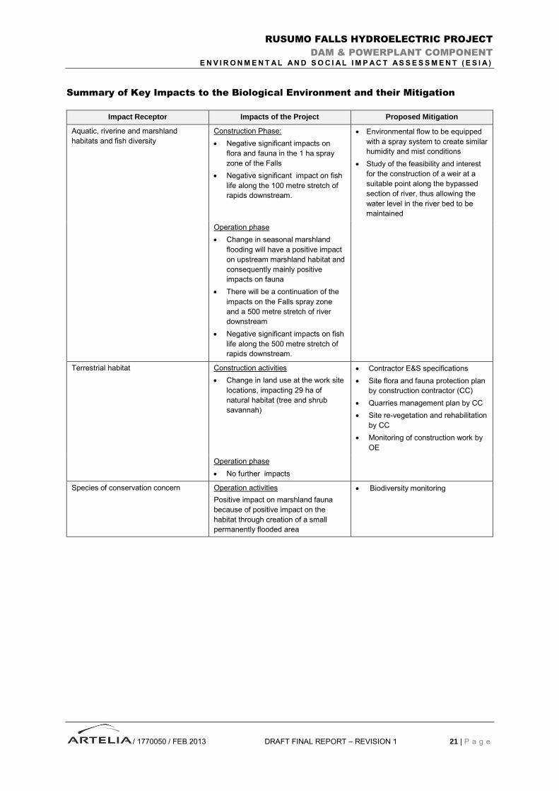
Summary of Key Impacts to the Biological Environment and their Mitigation
Impact Receptor Impacts of the Project Proposed Mitigation
Aquatic, riverine and marshland
habitats and fish diversity
Construction Phase:
Negative significant impacts on
flora and fauna in the 1 ha spray
zone of the Falls
Negative significant impact on fish
life along the 100 metre stretch of
rapids downstream.
Environmental flow to be equipped
with a spray system to create similar
humidity and mist conditions
Study of the feasibility and interest
for the construction of a weir at a
suitable point along the bypassed
section of river, thus allowing the
water level in the river bed to be
maintained
Operation phase
Change in seasonal marshland
flooding will have a positive impact
on upstream marshland habitat and
consequently mainly positive
impacts on fauna
There will be a continuation of the
impacts on the Falls spray zone
and a 500 metre stretch of river
downstream
Negative significant impacts on fish
life along the 500 metre stretch of
rapids downstream.
Terrestrial habitat Construction activities
Change in land use at the work site
locations, impacting 29 ha of
natural habitat (tree and shrub
savannah)
Contractor E&S specifications
Site flora and fauna protection plan
by construction contractor (CC)
Quarries management plan by CC
Site re-vegetation and rehabilitation
by CC
Monitoring of construction work by
OE
Operation phase
No further impacts
Species of conservation concern Operation activities
Positive impact on marshland fauna
because of positive impact on the
habitat through creation of a small
permanently flooded area
Biodiversity monitoring
RUSUMO FALLS HYDROELECTRIC PROJECT
DAM & POWERPLANT COMPONENT
E N V I R O N M E N T A L A N D S O C I A L I M P A C T A S S E S S M E N T ( E S I A )
/ 1770050 / FEB 2013 DRAFT FINAL REPORT – REVISION 1 22 | P a g e
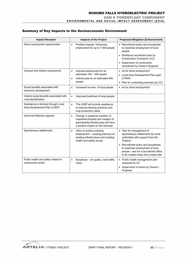
Summary of Key Impacts to the Socioeconomic Environment
Impact Receptor Impacts of the Project Proposed Mitigation (Enhancement)
Direct employment opportunities Positive impacts: Temporary
employment for up to 1,000 people
Recruitment policy and procedures
to maximise employment of local
people
Workforce recruitment plan by
Construction Contractor (CC)
Supervision of construction
recruitment by Owner’s Engineer
Induced and indirect employment Induced employment for an
estimated 100 – 200 people
Indirect jobs for an estimated 600
people
As for direct employment
Local Area Development Plan (part
of RAP)
Plan for contracting services (by CC)
Social benefits associated with
economic development
Increased income of local people As for direct employment
Indirect social benefits associated with
rural electrification
Improved livelihood of local people
Assistance to farmers through Local
Area Development Plan (LADP)
The LADP will provide assistance
to improve farming practices and
crop production yields
Improved fisheries capacity Change in seasonal variation of
marshland flooded and creation of
permanently flooded area will have
a positive impact on fish biomass
Spontaneous settlements Influx of workers seeking
employment – causing pressure on
existing infrastructure and creating
health and safety issues
Plan for management of
spontaneous settlements (by local
authorities with support from the
Project)
Recruitment policy and procedures
to maximise employment of local
people – and for a recruitment office
to be created away from project site
Public health and safety related to
construction works
Nuisances – air quality, road traffic,
noise
Public health management plan
prepared by CC
Supervision of works by Owner’s
Engineer
RUSUMO FALLS HYDROELECTRIC PROJECT
DAM & POWERPLANT COMPONENT
E N V I R O N M E N T A L A N D S O C I A L I M P A C T A S S E S S M E N T ( E S I A )
/ 1770050 / FEB 2013 DRAFT FINAL REPORT – REVISION 1 23 | P a g e
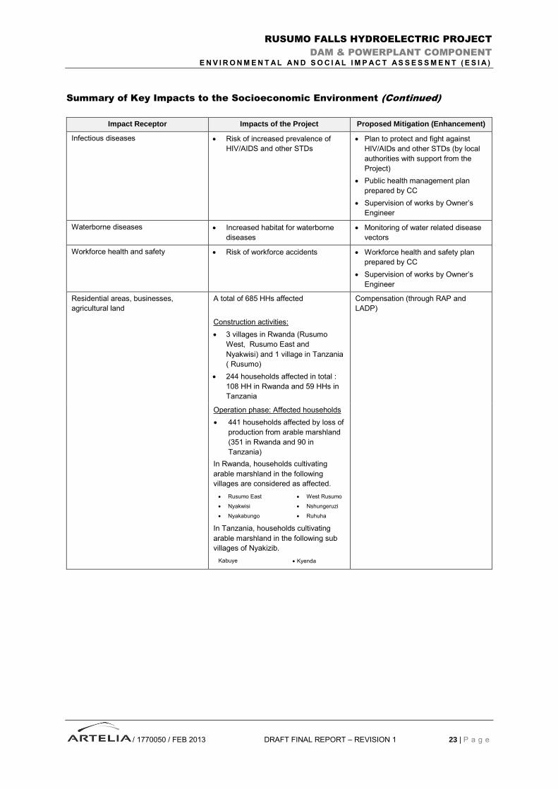
Summary of Key Impacts to the Socioeconomic Environment (Continued)
Impact Receptor Impacts of the Project Proposed Mitigation (Enhancement)
Infectious diseases Risk of increased prevalence of
HIV/AIDS and other STDs
Plan to protect and fight against
HIV/AIDs and other STDs (by local
authorities with support from the
Project)
Public health management plan
prepared by CC
Supervision of works by Owner’s
Engineer
Waterborne diseases Increased habitat for waterborne
diseases
Monitoring of water related disease
vectors
Workforce health and safety Risk of workforce accidents Workforce health and safety plan
prepared by CC
Supervision of works by Owner’s
Engineer
Residential areas, businesses,
agricultural land
A total of 685 HHs affected
Construction activities:
3 villages in Rwanda (Rusumo
West, Rusumo East and
Nyakwisi) and 1 village in Tanzania
( Rusumo)
244 households affected in total :
108 HH in Rwanda and 59 HHs in
Tanzania
Compensation (through RAP and
LADP)
Operation phase: Affected households
441 households affected by loss of
production from arable marshland
(351 in Rwanda and 90 in
Tanzania)
In Rwanda, households cultivating
arable marshland in the following
villages are considered as affected.
Rusumo East
Nyakwisi
Nyakabungo
West Rusumo
Nshungeruzi
Ruhuha
Nyakabungo
Ruhuha
In Tanzania, households cultivating
arable marshland in the following sub
villages of Nyakizib.
Kabuye Kyenda Sub-villages Kabuye
RUSUMO FALLS HYDROELECTRIC PROJECT
DAM & POWERPLANT COMPONENT
E N V I R O N M E N T A L A N D S O C I A L I M P A C T A S S E S S M E N T ( E S I A )
/ 1770050 / FEB 2013 DRAFT FINAL REPORT – REVISION 1 24 | P a g e
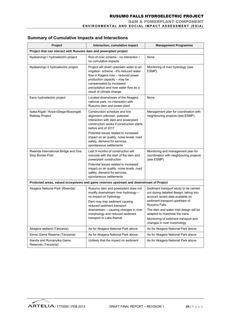
Summary of Cumulative Impacts and Interactions
Project Interaction, cumulative impact Management Programme
Project that can interact with Rusumo dam and powerplant project
Nyabarongo I hydroelectric project Run-of-river scheme - no interaction /
no cumulative impacts
None
Nyabarongo II hydroelectric project Project will divert upstream water to an
irrigation scheme - 6% reduced water
flow in Kagera river – reduced power
production capacity – may be
compensated by increased
precipitation and river water flow as a
result of climate change
Monitoring of river hydrology (see
ESMP)
Kano hydroelectric project Located downstream of the Akagera
national park, no interaction with
Rusumo dam and power plant
None
Isaka-Kigali / Keza-Gitega-Musongati
Railway Project
Construction schedule and line
alignment unknown, potential
interaction with dam and powerplant
construction works if construction starts
before end of 2017
Potential issues related to increased
impact on air quality, noise levels, road
safety, demand for services,
spontaneous settlements
Management plan for coordination with
neighbouring projects (see ESMP)
Rwanda International Bridge and One
Stop Border Post.
Last 9 months of construction will
coincide with the start of the dam and
powerplant construction
Potential issues related to increased
impact on air quality, noise levels, road
safety, demand for services,
spontaneous settlements
Monitoring and management plan for
coordination with neighbouring projects
(see ESMP)
Protected areas, valued ecosystems and game reserves upstream and downstream of Project
Akagera National Park (Rwanda) Rusumo dam and powerplant does not
modify downstream river hydrology –
no impact on hydrology
Dam may trap sediment causing
reduced sediment transport
downstream – causing changes in river
morphology and reduced sediment
transport to Lake Ihemat
Sediment transport study to be carried
out during detailed design, taking into
account recent data available on
sediment transport upstream of
Rusumo Falls.
The dam and water inlet design will be
adapted to maximise the trans
Monitoring of sediment transport and
changes in river morphology
Akagera wetland (Tanzania) As for Akagera National Park above As for Akagera National Park above
Kimisi Game Reserve (Tanzania) As for Akagera National Park above As for Akagera National Park above
Ibanda and Rumanyika Game
Reserves (Tanzania)
Unlikely that the impact on sediment As for Akagera National Park above
RUSUMO FALLS HYDROELECTRIC PROJECT
DAM & POWERPLANT COMPONENT
E N V I R O N M E N T A L A N D S O C I A L I M P A C T A S S E S S M E N T ( E S I A )
/ 1770050 / FEB 2013 DRAFT FINAL REPORT – REVISION 1 25 | P a g e
ENVIRONMENTAL MANAGEMENT PLAN
Public Consultation and Disclosure
A key guiding principle to the Public Consultation and Public Disclosure (PCDP) process has been that
it has involved free, prior and informed consultations with potentially affected communities to enable
informed participation.
Community engagement activities started in 2007 when the Full Development Scheme was being
studied. During 2007-2008 hundreds of interviews and focus groups were carried out in the Full
development Scheme project area of influence. Then in 2011 a comprehensive government
stakeholder consultation process was carried out and additional community and household
consultations and investigations. In July 2011 – Feb. 2012 further consultation with 9 000 Project
Affected People for the Intermediate Development Scheme was carried out and village-level
resettlement committees set up. In September 2011 in Kirehe and Ngoma workshops with district
officials were organised to prepare the Local Development Plan. In December 2011 and January 2012
in Kirehe and Ngoma, focus groups were held regarding on land tenure and vulnerable groups.
Under the RoR scheme there are reduced social and environmental impacts compared to the Full and
Intermediate Development Scheme. In November 2012 it was necessary to inform those people who
would no longer be impact by the project of the reduced impact. There expectations will be managed
through the Local Area Development Plan (LADP).
The Community engagement activities that were carried out for the Run-of-River Scheme have
involved a self-validation exercise to validate the list the Project Affecte People and the use of arable
marshland. Consultations with resettlement committees were carried out at the same time to establish
and assess how to manage village/sector grievances. Local/international NGOs and other
development partners attended these meetings.
The Process for approval and disclosure is in process. First draft reports of the ESIA, RAP and LADP
for the Run-of-River Scheme were presented to the Rusumo Technical Advisory Committee (TAC), the
Project Implementation Committee (PIC) and the Council of Ministers (COM) in Bujumbura on 27-28
November, 2012. In December 2012, the draft reports were presented to District Task Forces in their
respective countries. On the 18th December 2012, the draft reports were presented to Kirehe
Taskforce (Rwanda) and on 20th December, presented to Ngara Taskforce (Tanzania). In both cases,
the taskforces commended the progress made in the draft ESIA and RAP and were pleased with
reduced Environmental and Social Impacts. On 4th and 5th February 2013, the second draft reports
were discussed by representatives of various ministries from the three countries and the development
partners. Participants from the three countries represented institutions namely: Ministries of Energy,
Minerals, Environment, Agriculture, Natural Resources, National Environmental Management
Councils, Utility Agencies, District Heads, Country Investment Agencies, Forest Reserve Management
Heads, NGO representatives, and Development Partners.
The plan for disclosure is as follows: RAP, ESIA and LADP will be disclosed in the 28th February
2013. In March 2013 the Share Holder’s Agreement (SHA), Implementation Agreement (IA) and
Power Purchase Agreement (PPA) will be established. Project Appraisal (PAD) is also planned for
March 2013.

RUSUMO FALLS HYDROELECTRIC PROJECT
DAM & POWERPLANT COMPONENT
E N V I R O N M E N T A L A N D S O C I A L I M P A C T A S S E S S M E N T ( E S I A )
/ 1770050 / FEB 2013 DRAFT FINAL REPORT – REVISION 1 26 | P a g e
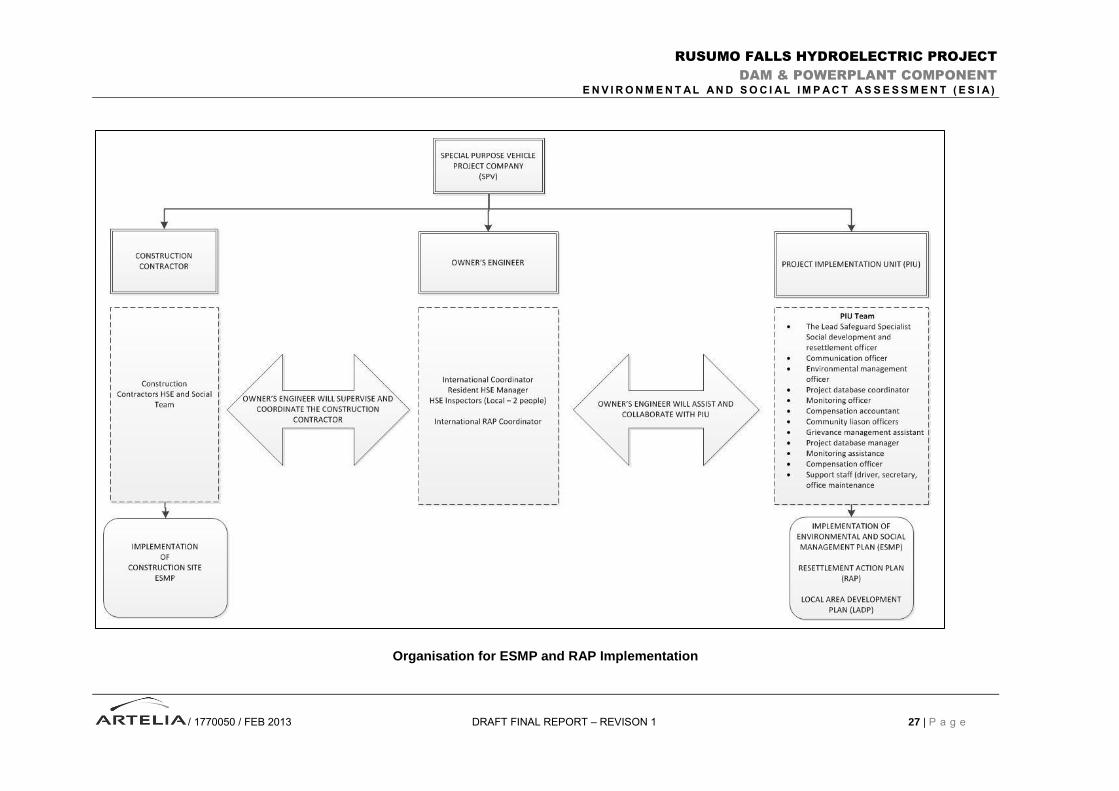
Organisation of Environmental and Social Management
The Project will be developed under the following conventional conditions:
The Project is a joint development undertaken by the Governments of Burundi, Rwanda and Tanzania. The role of project owner is delegated to a Special Purpose Vehicle Project Company (SPV). The SPV shall be responsible for all aspects of project management, including those associated with its environmental and social issues.
Appointment of an Owner’s Engineer (OE) to assist the Owner for the correct design and construction of the Project;
Appointment of Construction Contractors, the role of Head Contractor being dedicated to the one in charge of main civil works.
Three levels of organization, fully complementary, will be set-up:
The SPV, which will have to provide for all aspects related to environment and social (i) supervision of activities carried out prior, during and after construction of the project and (ii) coordination with other stakeholders including other Government Agencies and the World Bank. The SPV will create a unit referred to as the Project Implementation Unit (PIU) which will be responsible for E&S aspects;
The Owner’s Engineer Environmental and Social Management Team (OE-ESMT), who is to provide coordination and supervision for all environment-related activities during construction, and to report regularly to the PIU Project Director;
The Contractor Environmental Management Group (CC-EMG), who is to provide resources for, and effective implementation of, all measures which are defined in the ESMP and in the contract documentation. There will be one CC-EMG if a Head Contractor is overtaking coordination responsibility for all contractors or one CC-EMG for each major Construction Contract (for example civil works, electro-mechanical and transmission line).
Environmental staffs in the PIU, OE and CC are intended to be independent of construction staff.
Environmental staff will work alongside construction staff, however they will report through separate
management up to the Project Director for the OE and to the executive management level in the HC
and each CC.
The organisation is illustrated in the Figure overleaf.
Cost
The estimated project cost for the dam and powerplant is 346 million USD, which can be broken down
as follows:
Civil, Mechanical and Engineering costs: 317 Million USD
ESMP (see Chapter 7): 6.6 Million USD
RAP: 7.4 Million USD
LADP: 15 Million USD
RUSUMO FALLS HYDROELECTRIC PROJECT
DAM & POWERPLANT COMPONENT
E N V I R O N M E N T A L A N D S O C I A L I M P A C T A S S E S S M E N T ( E S I A )
/ 1770050 / FEB 2013 DRAFT FINAL REPORT – REVISON 1 27 | P a g e
Organisation for ESMP and RAP Implementation