Rush County Zoning Ordinance - IN.govsee... · 2 rush county zoning -- table of contents section _...
168
1
Transcript of Rush County Zoning Ordinance - IN.govsee... · 2 rush county zoning -- table of contents section _...

1

2
RUSH COUNTY ZONING -- TABLE OF CONTENTS
SECTION _ PAGE
General information 3
Section 1 - Establishment of Districts for Zoning Map 5
Section 2 - Rules of Interpretation of District Boundaries 7
Section 3 - Application of District Regulations 8
Section 4 - Non-Conformity 9
Section 5 - Definitions 15
Section 6 - Schedule of District Regulations Adopted 23
Wireless Telecommunication Facilities 24
Wind Energy Conversion Systems 27
Section 7 – Restrictions per District 47
Residential District R-1 47
Residential District R-2 54
Planned Unit Development District 58
Mobile Home District 63
Manufacturing District 65
Business District 76
Commercial District 83
Agriculture District A-1 92
Agriculture District A-1R 96
Agriculture District A-2 101
Agriculture District A-3 104
Agriculture District A-4 110
Animal Unit Conversion Chart Table A 115
Appendix A- Agricultural Definitions 116
Appendix B – CFO\CAFO Site Scoring System 119
Appendix C – Housing Scoring System 121
Appendix D – Notice of Agricultural Activities 122
Open Land District (Flood Hazard Area) 123
Section 8 - Administration and Enforcement 153

3
Section 9 - Board of Zoning Appeals 155
Section 10 – Board of Zoning Appeals, Powers & Duties 156
Section 11 – Appeals from the Board of Zoning Appeals 160 Section 11A – A Right to Enter 160 Section 11 B – Regulations of Nuisance Elements 161 Section 12 – Duties of Executive Director of Board of Zoning Appeals, Legislative Bodies & Courts on matter of appeal 161 Section 13 – Schedule of Fees 161
Section 14 - Amendments of Ordinance Minimum 163
Section 15 - Provisions to Requirements 164
Section 16 - Complaints Regarding Violations 164
Section 17 - Penalties for Violation 164
Section 18 – Separability Clause 165
Schedule of Uses 165
Amendments
Original Document Effective June 1974
First Revision February 1988
Second Revision August 1993
Third Revision October 1998
Fourth Revision Flood Ordinance Adopted 04-01-01
Fifth Revision Planned Unit Development 04-26-04
Add Code use 210 Manufacturing Workshop 06-01-04
Sixth Revision Set back for Arterial Highway 12-05-05
Seventh Revision Delete 6.3.1.9 Parking Storage of Equipment 2-7-06
R-2 Residential District 09-05-06, Update Flood Hazard
Ordinance 9-18-06, Wireless Telecommunication
Facilities 9-19-06, Amend Fee Schedule 9-25-06
Eighth Revision Delete Section 6.3.6 – add A-1, A-1R, A-2, A-3, A-4
07-02-07
Ninth Revision One Year review and update of eighth revision
01-05-09 and (added WECS ordinance section)
4
GENERAL INFORMATION
“Zoning is built on the premise that the private market for land use, in a mature urban society,
cannot be permitted to make land use allocations without creating severe diseconomies in the
urban development pattern.”* Zoning also derives from the belief that the individual land
owner does not and cannot, in today’s complex technological society, fully understand how to
make safe and efficient use of his land, both in the individual and the societal context. The
author of a zoning code must also be aware that often the individual does not care about such
things. Every loophole must be closed, so that the unscrupulous ones have no way to evade the
spirit of the ordinance. That is the tone in which many zoning ordinances are written.
However, the basic controversy which every zoning ordinance attempts to resolve is that of the
conflict between the rights of the individual as opposed to the rights of the society and vice
versa. Possible resolutions of this conflict range from anarchy to complete societal control of
every action and thought of the individual. In the United States, we tend to take a middle
course in everything, because we generally believe excesses are not desirable. Zoning is no
different. The general trend in zoning has been to maintain certain rights of the individual, but
to carefully control them in the hope that his development will not have adverse effects on the
society around him. This is the basic aim of zoning in general, and this ordinance in particular.
*Source: Mandelker, Dan R. The New Zoning: Legal, Administrative, and Economic Concepts and
Techniques (New York, 1970), pg. 14

5
An ordinance establishing comprehensive zoning regulations for the county of Rush and
providing for the administration, enforcement, and amendment thereof, in accordance with the
provisions of State Law and for the repeal of all ordinances in conflict herewith:
WHEREAS: State Law empowers the county to enact a zoning ordinance and to provide for
its administration, enforcement, and amendment and,
WHEREAS: the Board of County Commissioners, the City Council and the Town Board of
Trustees deems it necessary, for the purpose of promoting the health, safety, or general welfare
of Rush County to enact such an ordinance, and,
WHEREAS: the Board of County Commissioners, the City Council, and the Town Board of
Trustees pursuant to the provisions of State Statutes has appointed an Area Plan Commission
to recommend the boundaries of the various original districts and appropriate regulations to be
enforced therein, and,
WHEREAS: the Area Plan Commission has divided the County into districts and has
prepared regulations pertaining to such districts in accordance with a comprehensive plan to
the end that adequate light, air, convenience of access and safety from fire, flood, and other
danger may be secure; that congestion in the public streets may be lessened or avoided; that
property values may be preserved, that the public health, safety, comfort, convenience and
general welfare may be promoted, and
WHEREAS: the Area Plan Commission has given reasonable consideration, among other
things to the character of the districts and their particular suitability for particular uses, with a
view to conserving the value of buildings and encouraging the most appropriate use of land
throughout the County and,
WHEREAS: the Area Plan Commission has given due public notice of hearings related to
zoning districts, regulations, and restrictions, and has held such public hearings, and,

6
WHEREAS: all requirements of Chapter 138, Acts of 1957, as amended with regard to the
preparation of the ordinance has been met;
NOW THEREFORE BE IT ORDAINED BY THE PEOPLE OF THE COUNTY OF
RUSH, INDIANA:
SECTION 1: ESTABLISHMENT OF DISTRICTS PROVISION FOR
OFFICIAL ZONING MAP
1.1 OFFICIAL ZONING MAP - The County is hereby divided into zones, or districts, as
shown on the Official Zoning Map which, together with all explanatory matter thereon is
hereby adopted by reference and declared to be a part of this ordinance.
The Official Zoning Map shall be identified by certification by and bearing the seal of the
county under the following words: “This is to certify that this is the Official Zoning Map
referred to in Section 1 of Ordinance Number ___ of the County of Rush, State of Indiana, (or
Town of Carthage, or Town of Glenwood) together with the date of adoption of the
ordinance.” (Note: Rushville City Ordinance adopted March 2006)
Official zoning maps amended to include flood hazard areas as delineated on the Flood
Insurance Rate Maps and Flood Boundary-Floodway Maps included in the Flood Insurance
Study for Rush County dated December 1, 1982.
If in accordance with this provision of the ordinance and Chapter 138, Acts of 1957, changes
are made in district boundaries or other matter portrayed on the Official Zoning Map, such
changes shall be entered on the Official Zoning Map promptly after the amendment has been
approved by the Board of County Commissioners or Town Board of Trustees with an entry on
the Official Zoning Map as follows: On _________________ by official action of the Board
of County Commissioners (or City Council or Town Board of Trustees), the following changes
were made in the Official Zoning Map:
which entry shall be signed by the President of the Plan Commission and attested by the
County Auditor, or town Clerk-Treasurer. No amendment to this ordinance which involved
7
matter portrayed on the Official Zoning Map shall become effective until after such change and
entry has been made on said map.
No changes of any nature shall be made in the Official Zoning Map or matter shown thereon
except in conformity with the procedures set forth in this ordinance. Any unauthorized change
of whatever kind of any person or persons shall be considered a violations of this ordinance
and punishable as provided under Section 16.
Regardless of the existence of purported copies of the Official Zoning Map which may from
time to time be made or published, the Official Zoning Map which shall be located in the office
of the County Auditor shall be the final authority as to the current zoning status of land and
water area, buildings, and other structures in the county.
1.2 Replacement of Official Zoning Map - In the event that the Official Zoning Map
becomes damaged, destroyed, lost, or difficult to interpret because of the nature or number of
changes and additions, the Board of County Commissioners, or Town Board of Trustees may
by resolution adopt a new Official Zoning Map which shall supersede the prior Official Zoning
Map. The new Official Zoning Map may correct drafting or other errors or omissions in the
prior Official Zoning Map, but no such correction shall have the effect of amending the
original Official Zoning Map or any subsequent amendment thereof. The new Official Zoning
Map shall be identified by the signature of the President of the Plan Commission attested by
the County Auditor, or Town Clerk and bearing the seal of the county, or town under the
following words: “This is to certify that this Official Zoning Map supersedes and replaces the
Official Zoning Map adopted __________ as part of Ordinance No. _____ of the county of
Rush, Indiana” (or Town of Carthage or Town of Glenwood). Unless the prior Official Zoning
Map has been lost, or has been totally destroyed, the prior map or any significant parts thereof
remaining shall be preserved, together with all available records pertaining to its adoption or
amendment.

8
SECTION 2: RULES FOR INTERPRETATION OF DISTRICT
BOUNDARIES
Where uncertainty exists as to the boundaries of districts as shown of the Official Zoning Map,
the following rules shall apply:
2.1 Boundaries indicated as approximately following the center lines of streets, highways, or
alleys shall be considered to follow such center line;
2.2 Boundaries indicated as approximately following platted lot lines shall be construed as
following such lot lines;
2.3 Boundaries indicated as approximately following city limits shall be construed as following
such city limits;
2.4 Boundaries indicated as following railroad lines shall be construed to be midway between
the main tracks;
2.5 Boundaries indicated as following shore lines shall be construed to follow such shore lines,
and in the event of change in the shore line shall be construed as moving with the actual shore
line; boundaries indicated as approximately following the center lines of streams, rivers,
canals, lakes, or other bodies of water shall be construed to follow such center line;
2.6 Boundaries indicated as approximately following flood plain lines shall be construed to
follow such lines. In addition to the boundary shown on the zone maps, the boundary of minor
ditches and streams shall be designated as being at least 5 vertical feet from any stream or shall
be 100 feet horizontally from the edge of the water, whichever is the greater distance. A
stream, river or creek shall be defined as one which flows at least 180 days of the year.
Further, it is advised that the banks and at least 10 feet beyond the banks be left in as natural
state as possible.
9
2.7 Boundaries indicated as parallel to or extension of features indicated in subsections 1
through 6 above shall be so construed. Distances not specifically indicated on the Official
Zoning Map shall be determined by the scale of the map.
2.8 Where physical or cultural features existing on the ground are at variance with those shown
on the Official Zoning Map, or in other circumstances not covered by subsection 1 through 6
above, the Board of Zoning Appeals shall interpret the district boundaries.
2.9 Where a district boundary line divides a lot which was in single ownership at the time of
passage of this ordinance the Board of Zoning Appeals may permit, as a special exception, the
extension of the regulations for either portion of the lot not to exceed 50 feet beyond the
district line into the remaining portion of the lot.
SECTION 3: APPLICATION OF DISTRICT REGULATIONS
The regulations set by this ordinance within each district shall be minimum regulations and
shall apply uniformly to each class or kind of structure or land, and particularly, except as
hereinafter provided:
3.1 No building, structure, or land use change shall hereafter be erected, constructed,
reconstructed, moved, or structurally altered except in conformity with all of the regulations
herein specified for the district in which it is located (See exception in Agriculture District
6.3.13).
3.2 No building or other structure shall hereafter be erected or altered:
a. To exceed the floor area ratio
b. To have narrower or smaller rear yards, front yards, side yards, or open
spaces than herein required; or in any other manner contrary to the provisions of
this ordinance.
10
3.3 No part of a yard, or other open space, or off-street parking or loading space required about
or in connection with any building for the purpose of complying with this ordinance, shall be
included as part of a yard, open space, or off-street parking or loading space similarly required
for any other building.
3.4 No yard or lot existing at the time of passage of this ordinance shall be reduced in a
dimension or area below the minimum requirements set forth herein. Yards or lots created
after the effective date of this ordinance shall meet at least the minimum requirements
established by this ordinance.
SECTION 4: NON-CONFORMING LOTS, NON-CONFORMING
USES OF LAND, NON-CONFORMING STRUCTURES,
NON-CONFORMING USES OF STRUCTURES AND
PREMISES, AND NON-CONFORMING
CHARACTERISTICS OF USE
4.1 Intent – Within the districts established by this ordinance or amendments that may later be
adopted there exist
4.1.1 Lots
4.1.2 Structures
4.1.3 Uses of land and structures, and
4.1.4 Characteristics of use which were lawful before this ordinance was passed
or amended, but which would be prohibited, regulated, or restricted under
the terms of this ordinance or future amendment. It is the intent of this
ordinance to permit these non-conformities to continue until they are
removed, but not to encourage their survival. It is further the intent of
this ordinance that non-conformities shall not be enlarged upon, expanded
or extended, nor be used as grounds for adding other structures or uses
prohibited elsewhere in the same district. Non-conforming uses are
declared by this ordinance to be incompatible with permitted uses in the
11
districts involved. A non-conforming use of a structure, a
non-conforming use of land, or a non-conforming use of a structure
and land in combination shall not be extended or enlarged after passage of
this ordinance by attachment on a building or premises of additional signs
intended to be seen from off the premises, or by the addition of other
uses, of a nature which would be prohibited generally in the district
involved. It is the intent of this ordinance to exempt certain non-
conformities as provided in Section 4.4.4 and Section 4.5.7. To avoid
undue hardship, nothing in this ordinance shall be deemed to require a
change in the plans, construction, or designated use of any building on
which actual construction was lawfully begun prior to the effective date
of adoption or amendment of this ordinance and upon which actual
building construction has been carried on diligently. Where excavation
or demolition or removal of any existing building has been substantially
begun preparatory to rebuilding, such excavation or demolition or
removal shall be deemed to be actual construction, provided that work
shall be carried on diligently.
4.2 Non-Conforming Lots of Record
4.2.1 In any district in which single-family dwellings are permitted, a single-
family dwelling and customary accessory buildings may be erected on any
single lot of record at the effective date of adoption or amendment of this
ordinance, not withstanding limitations imposed by other provisions of this
ordinance. Such lot must be in separate ownership and not of continuous
frontage with other lots in the same ownership. These provisions shall apply
even though such lot fails to meet the requirements of area or width, or both,
that are generally applicable in the district, provided that yard dimensions and
requirements other than those applying to area or width, or both, of the lot shall
conform to the regulations for the district in which such lot is located. Variance
of yard requirements shall be obtained only through action of the Board of
Zoning Appeals. If two or more lots or combination of lots and portions of lots

12
with continuous frontage in single ownership are of record at the time of
passage or amendment of this ordinance and if all or part of the lots do not meet
the requirements established for lot width and area, the lands involved shall be
considered to be an undivided parcel for the purposes of this ordinance, and no
portion of said parcel shall be used or sold in a manner which diminishes
compliance with lot width and area requirements established by this ordinance,
nor shall any division of any parcel be made which creates a lot with width or
area below the requirements stated in this ordinance.
4.2.2 A legal lot of record, as evidenced by a deed which was recorded prior to
the adoption of this ordinance, may be used for any purpose permitted within its
agricultural district even if the size of the lot does not meet the developmental
standards or other requirements set forth herein so long as all other
developmental standards and requirements are met.
4.3 Non-Conforming Uses of Land (Or Land with Accessory Buildings only, such as Junk
Yards) Where at the time of passage of this ordinance lawful use of land exists which would
not be permitted by the regulations imposed by this ordinance, and where such use involved an
Accessory Building, the use may be continued so long as it remains otherwise lawful,
provided:
4.3.1 No such non-conforming use shall be enlarged or increased, nor extended
to occupy a greater area of land than was occupied at the effective date of
adoption or amendment of this ordinance;
4.3.2 No such non-conforming use shall be moved in whole or in part to any
portion of the lot or parcel other than that occupied by such use at the
effective date of adoption or amendment of this ordinance;
4.3.3 If any such non-conforming use of land ceases for any reason for a period
of more than 60 days, any subsequent use of such land shall conform to
13
the regulations specified by this ordinance for the district in which the land
is located.
4.3.4 No additional structure not conforming to the requirements of this
ordinance shall be erected in connection with such non-conforming use of land.
4.4 Non Conforming Structures Where a lawful structure exists at the effective date of
adoption or amendment of the ordinance that could not be built under the terms of the
ordinance by reason of restrictions on area, lot coverage, height, yards, its location on the lot,
or other requirements concerning the structure, such structure may be continued so long as it
remains otherwise lawful, subject to the following provisions:
4.4.1 No such non-conforming structure may be enlarged or altered in a way
which increases its non-conformity but any structure or portion thereof
may be altered to decrease its non-conformity. A single-family dwelling
may be enlarged and an Improvement Location Permit shall be issued
without a variance hearing provided that yard dimensions and
requirements other than those applying to area or width, or both, of the lot
shall conform to the regulations for the district in which such a lot is
located.
4.4.2 Should such non-conforming structure or non-conforming portion of
structure be destroyed by any means to an extent of more than 50 percent
of its replacement cost at time of destruction, it shall not be reconstructed
except in conformity with the provisions of this ordinance (as amended
effective 08-09-93).
4.4.3 Should such structure be moved for any reason for any distance whatever,
it shall thereafter conform to the regulations for the district in which it is
located after it is moved.

14
4.5 _ Non-Conforming Uses of Structures or of Structures and Premises in Combination
If lawful use involving individual structures or of structure and premises in combination exists
at the effective date of adoption or amendment of this ordinance that would not be allowed in
the district under the terms of this ordinance, the lawful use may be continued so long as it
remains otherwise lawful, subject to the following provisions:
4.5.1 No existing structure devoted to a use not permitted by this ordinance in
the district in which it is located shall be enlarged, extended, constructed,
reconstructed, moved or structurally altered except in changing the use of
the structure to a use permitted in the district in which it is located.
4.5.2 Any non-conforming use may be extended throughout any parts of a
building which were manifestly arranged or designed for such use at the
time of adoption or amendment of this ordinance, but no such use shall be
extended to occupy any land outside such building.
4.5.3. If no structural alterations are made, any non-conforming use of a
structure, or structure and premises, may as a special exception be
changed to another non-conforming use provided that the Board of
Zoning Appeals, either by general rule or by making findings in the
specific case, shall find that the proposed use is equally appropriate or
more appropriate to the district than the existing non-conforming use. In
permitting such change, the Board may require appropriate conditions and
safeguards in accord with provisions of this ordinance.
4.5.4 Any structure, or structure and land combination, in or on which a non-
conforming use is superseded by a permitted use, shall thereafter conform
to the regulations for the district, and the non-conforming use may not
thereafter be resumed.
15
4.5.5 When a non-conforming use of a structure, or structure and premises in
combination, is discontinued or abandoned for twelve consecutive months
or for 18 months during any three-year period (except when government
action impedes access to the Premises), the structure, or structure and
premises in combination, shall not thereafter be used except in conformity
with the regulations of the district in which it is located.
4.5.6 Where non-conforming use status applies to a structure and premises in
Combination, removal or destruction of the structure shall eliminate the non-
conforming status of the land. Destruction for the purpose of this subsection is
defined as damage to an extent of more than 50 percent of the replacement cost
at time of destruction.
4.5.7 In accord with IC 36-7-4-616, agricultural nonconforming use land
remains as nonconforming use land as long as the land is used for
agricultural purposes for any three (3) year period in a five (5) year period.
4.6 Repairs and Maintenance On any con-conforming structure or portion of a structure
containing a non-conforming use, work may be done in any period of 12 consecutive months
on ordinary repairs, or on repair or replacement of non-bearing walls, fixtures, wiring, or
plumbing, to an extent not exceeding 10 percent of the current replacement cost of the non-
conforming structure and market value of real estate, or non-conforming portion of the
structure as the case may be, provided that the cubic content existing when it became non-
conforming shall not be increased.
If a non-conforming structure or portions of a structure containing a non-conforming use
becomes physically unsafe or unlawful due to lack of repairs and maintenance, and is declared
by any duly authorized official to be unsafe or unlawful by reason of physical condition, it
shall not thereafter be restored, repaired, or rebuilt except in conformity with the regulations of
the district in which it is located. Nothing in this ordinance shall be deemed to prevent the
strengthening or restoring to a safe condition of any building or part whereof declared to be
unsafe by any official charged.

16
4.7 Uses Under Special Provisions Not Non-Conforming Uses Any use which is permitted
as special exception in a district under the terms of this ordinance (other than a change through
Board of Zoning Appeals action from a non-conforming use to another use not generally
permitted in the district) shall not be deemed a non-conforming use in such district, but shall
without further action be considered a conforming use.
4.8_ Non-Conforming Uses in Open Land (Flood Hazard) District Any building, structure
or use of land in the Open Land District which is not in conformance with the ordinance
constitutes a non-conforming use. All applications to repair, extend, or enlarge a non-
conforming use shall be forwarded to Indiana Department of Natural Resources for review and
comment. All terms and conditions imposed by Natural Resources for review and comment.
All terms and conditions imposed by Natural Resources shall be incorporated into the issuance
of any local permit.
SECTION 5: DEFINITIONS
5.1 For the purposes of this ordinance, certain terms or words used herein shall be interpreted
as follows:
5.1.1 Accessory building – A subordinate building such as a garage, enclosed
swimming pool or similar structure that is located on the same lot as the principal
building and is not used or designed for human occupancy.
5.1.2 Accessory use – An incidental and subordinate use such as driveways, curbs,
sidewalks, retaining walls, mailboxes, lamp posts, wireless telecommunications
structures for dwelling units, bird baths, fences and similar structures that relate to the
primary use of the lot and is a use other than human occupancy. The keeping of cats
and dogs which are domesticated to live inside the dwelling unit or in an outdoor
shelter is also an accessory use provided it is not for profit and is not a commercial
kennel.
17
5.1.3 Agriculture use on less than 10 acres (Code 824) – The growing of vegetation
including crops, horticulture, floriculture, and viticulture and the necessary buildings
and structures for packing and storing said products.
5.1.4 Alley – A right-of-way, other than a street, road, cross-walk, or easement, that
provides secondary access for the special accommodation of the abutting property.
5.1.5 Block – An area that abuts a street and lies between two adjoining streets or
barriers such as a railroad right-of-way or a water-way.
5.1.6 Boarding House – A building, not available to transients, in which meals are
regularly provided for compensation for at least three but not more than thirty persons.
5.1.7 Building – A roofed structure for the shelter, support, enclosure or protection of
persons, animals or property.
5.1.8 Business – Refers to the purchase, sale, or exchange of goods or services or the
maintenance for profit of offices or recreational or amusement enterprises.
5.1.9 Characteristic of Use – The use which is characteristic or the primary use of an
area of land.
5.1.10 Clean Record Award - Points are earned by an applicant who has operated a CFO/CAFO in Indiana for at least five (5) years without any IDEM violations during the previous five (5) year period. 5.1.11 D.U. (Dwelling Unit) – Any living unit of one room, or rooms connected
together intended to be occupied year-round by an economically independent unit of
humanity, such as bachelor, family, etc., as a place of abode or residence. This unit
usually contains a sleeping area, cooking and sanitary facilities. Occasionally, (as in
boarding houses) the cooking and/or sanitary facilities are shared with other people
18
who are not members of the same economic unit; included a mobile home if it has its
wheels and axle removed and is placed on a permanent foundation.
5.1.12 Farm – An area used for agricultural operations, including truck gardening,
forestry, the operation of a tree or plant nursery, or the production of livestock and
poultry. A farm is ten (10) acres or more. (As amended effective 02/01/88)
5.1.13 Flood Plain – those areas most vulnerable to flooding and other environmental
hazards which make them least suitable for development, and includes any flood plain,
floodway or floodway fringe district or combination thereof as illustrated on the official
zoning maps s the Open Land District which included the Flood Boundary and
Floodway Map as prepared by the Federal Insurance Administration.
5.1.14 Floor Area – The floor area means the sum of the gross horizontal area of the
several floors of the building or portion thereof, but not including floor area used for
off-street parking facilities and such basement floor areas that are used exclusively for
the maintenance and operation of the building. All horizontal dimensions shall be
taken from the exterior faces of the walls.
5.1.15 Floor area Ratio – The numerical value obtained through dividing the gross
floor area of a building or buildings by the total area of the lot or parcel of land on
which such building or buildings are located.
5.1.16 Front Lot Lines – Lot lines which border on a public right-of-way.
5.1.17 Front Yard – A yard extending between side lot lines across the front of a lot
adjoining a public street.
5.1.18 Home Occupation – A service occupation conducted in a D.U. but in which no
goods are sold on the premises other than what is produced there.
19
5.1.19 Junk Yard – A lot, land, or structure, or part there of, used for the collection,
storage or sale of waste paper, rags, scrap metal, or discarded material, or for the
collection, dismantling, storage, or salvage of machinery or vehicles not in running
condition, or for the sale of parts thereof. (As amended effective 02/01/88)
5.1.20 Livestock on less than 10 Acres (Code 825) - The keeping and raising of
livestock for pleasure or sale including horses, cattle, swine, sheep, goats, and similar
quadrupeds; chickens, turkeys, and similar fowl; dog and cat kennels and similar
domesticated pets; and, the necessary buildings for housing the livestock and storage of
their food supply. Does not include concentrated animal feeding operations (CAFO)
nor confinement feeding operations (CFO) as defined in the Ordinance.
5.1.21 Lot – An area of land, exclusive of street area but including adjacent areas that
are used as one.
5.1.22 Manufactured Home – A structure, transportable in one or more sections,
which is built on a permanent chassis and is designed for use with or without a
permanent foundation when attached to the required utilities. The term, “manufactured
home” does not include a recreational vehicle. (As amended effective 10/20/98
5.1.23 Manufactured Home Park – A parcel of land containing two or more spaces
with required improvements and utilities that are leased for the long term placement of
manufactured homes. (As amended effective 10/20/98)
5.1.24 Manufactured Home Subdivision – A subdivision containing individually
platted lots designed for the permanent placement of manufactured homes. (As
amended effective 10/20/98)
5.1.25 Manufactured Home Type 1 – A structure transportable in one or more
sections, which, in the completed mode, is twenty three (23) body feet or more in width
at its narrowest dimension, when erected on site is nine hundred fifty (950) or more
20
square feet, and which is built on a permanent chassis and designed to be used as a
dwelling with a permanent foundation when connected to the required utilities and
includes the plumbing, heating, and air conditioning and electrical systems contained
therein. It shall bear a label certifying it is built in compliance with the Federal
Manufactured Home Construction and Safety Act of 1974, which became effective
June 15, 1976. (As amended effective 10/20/98)
5.1.26 Manufactured Home Type 2 – A structure transportable in one or more
sections, which, in the traveling mode, is eight (8) body feet or more in width at its
narrowest dimension, or forty (40) body feet or more in length, or when erected on site
is at least three hundred twenty (320) or more square feet but not more than nine
hundred fifty (950) square feet, and which is built on a permanent foundation when
connected to the required utilities, and includes the plumbing, heating and air
conditioning, and electrical systems contained therein. It shall bear a label certifying it
is built in compliance with the Federal Manufactured Home Construction and Safety
Act of 1974, which became effective June 15, 1976. (As amended 10/20/98)
5.1.27 Manufacturing – The making of goods in a mechanical way, or anything so
made by machinery. (As amended effective 02/01/88)
5.1.28 Mobile – Either manufactured homes or mobile homes shall be considered to be
mobile if they are installed in a temporary fashion. Placement on a cement pad with tie
downs shall be considered to be temporary, when done in conjunction with the
attachment to other utilities. (As amended effective 10/20/98)
5.1.29 Mobile Home – A detached D.U. designed for transportation, after fabrication,
on streets or highways on its own wheels or on flatbed or other trailers, and arriving at
the site where it is to be occupied as a dwelling complete and ready for occupancy
except for minor and incidental unpacking and assembly operations, location on jacks
or other temporary foundations, connections to utilities, and the like. A travel trailer is

21
not to be considered a mobile home. A mobile home may be occupied as a dwelling
unit if it has its’ wheels and axle removed and is placed on a permanent foundation.
5.1.30 Mobile Home Park – An area of land on which two or more mobile homes are
regularly accommodated with or without charge including any building or other
structure, fixture or equipment that is used or intended to be used in providing that
accommodation.
5.1.31 Non-Conforming Use – A use that exists at the time a provision of this
ordinance is passed but does not comply with the same.
5.1.32 Parcel- Contiguous real estate that is identified by a given tax parcel number shall be considered a parcel herein.
5.1.33 Parking Stall – The area required for parking one automobile, with its
attendant maneuvering room. The area required for a parked car is held to be ten (10)
feet wide and twenty-two (22) feet long.
5.1.34 Permanent – Placement of a structure shall be considered to be permanent if it
is installed in such a fashion as to not be mobile. Pouring a cement footer and installing
a cement block foundation and securely attaching the structure to the foundation shall
be considered to be permanent, when done in conjunction with the attachment to other
utilities. (As amended effective 10/20/98)
5.1.35 Right-of-Way – That line which has been established as the edge of public
transportation rights, not necessarily the edge of the pavement of the road.
5.1.36 Public Thoroughfare – A right-of-way established for or dedicated to public
use.

22
5.1.37 Rear Lot Lines – Lot lines which intersect side lot lines but do not border
public rights-of-way, except alleys.
5.1.38 Rear Yard – A yard between the rear lot line (or lines) and the nearest
approach of a structure.
5.1.39 Recreational Equipment, Major – Equipment which must be hauled on a
trailer with two or more wheels or which has two or more wheels attached, such as a
boat trailer, travel trailer. The trailer by itself would be considered as being major
recreational equipment.
5.1.40 Satellite Dishes – Satellite Dishes are exempt from improvement location
permits, but must conform to zoning requirements. (As amended effective 02/01/88)
5.1.41 Setback – The shortest distance measured at right angles to a public right-of-
way which separates a structure from said public right-of-way.
5.1.42 Side Lot Lines – Lot lines which do not border on public rights-of-way except
alleys but which intersect lines that do border on public rights-of-way.
5.1.43 Side Yard – A yard between the side lot line (or lines) and the nearest approach
of a structure.
5.1.44 Sign – A free standing visual device or structure used for advertising display or
publicity purposes only.
5.1.45 Single Lot Subdivision – A subdivision that creates only one additional lot.
5.1.46 Special Exception – A use or structure which in most, many, or several cases
would be compatible with the type and character of development in a particular district.
Restrictions imposed by the Board of Zoning Appeals in addition to those for the
Permitted Uses of the district are required to be met. See Section 9.
23
5.1.47 Street – A right-of-way that is established by recorded plat to provide the
principal means of access to abutting property.
5.1.48 Structure – Anything constructed or erected with a fixed location on the
ground, or attached to something having a fix location on the ground. Local utility
poles providing local service are not considered structures. Satellite dishes are exempt
from improvement location permits, but must conform to zoning requirements. (As
amended effective 02/02/88)
5.1.49 Travel Trailer – A vehicular, portable structure built on a chassis, designed to
be used as a temporary dwelling for travel and recreational purposes, having a body
width not exceeding eight feet.
5.1.50 Travel Trailer Park – An area of land on which two or more travel trailers are
regularly accommodated with or without charge, including any building or any
structure, fixture, or equipment that is used or intended to be used in connection with
providing that accommodation.
5.1.51 Variance – A variance may be granted by the Board of Zoning Appeals to
allow an applicant relief from the requirements of the letter of the ordinance because of
unnecessary hardship or practical difficulty, as specified in Section 9.3.
5.1.52 Wind Energy Conversion System -Any structure or structures used for the capture of wind and used for the purpose of creating electric energy from that wind. 5.1.53 Wireless Telecommunications Facility – Any structure or structures used for the receiving and/or dispersal of radio, television, microwave, cellular telephone, paging, enhanced specialized mobile radio, personal communication services and similar technologies. A “tower” and an antenna” are wireless telecommunication structures.
SECTION 6: SCHEDULE OF DISTRICT REGULATIONS ADOPTED

24
6.1 Table: Schedule of Uses
6.1.1 The Schedule of Uses Table (See Appendix E) was prepared using a modified
form of the Standard System for Identifying and Coding Land Use Activities. A 3-digit
level of detail is indicated. All 3-digit numbers and descriptions of activities contain all
4-digit numbers and descriptions of activities as well. For example, if “711, Cultural
Activities” is indicted as permitted in the R district, then “7111: Libraries,” “7112
Museums.” “7113: Art Galleries,” and “7119: Other Cultural Activities,” are permitted
as well. (See Appendix E for the classification system.)
6.1.2 The table describes Permitted Uses; Special Exceptions and Prohibited uses for
each district established by this ordinance.
6.2 General Restrictions, Applicable to All Uses in All Districts
6.2.1 Any structure erected or moved for use as D.U. or with a replacement cost valued
at greater that $2,000.00 shall be easily accessible to fire and other emergency
equipment, and shall be on a lot adjacent to a public street or with access to an
approved private street.
6.2.2 Each proposed use shall not create such a volume of automotive traffic so as to
overburden the surrounding road system.
6.2.3 Temporary buildings and structures incidental to construction work are permitted,
only for the period of such work.
6.2.4 No accessory building shall be erected in any required yard, and no separate
accessory building shall be erected within 4 feet of any other building.

25
6.2.5 More than one structure housing a permitted or permissible principal use may be
erected on a single lot, provided that yard and other requirements of this ordinance shall
be met for each structure.
6.2.6 No structure, except fences and sign posts, shall be erected, placed, or moved
within 10 feet of any lot line.
6.2.7 Billboard and Advertising Sign-Boards- All freestanding billboards or advertising
sign-boards shall be 15 feet or more from any public right-of-way.
6.2.8 No structure shall be erected to a height greater than 35 feet; provided, however,
that this height limitation does not apply to barns and other farm buildings nor to spires,
belfries, cupolas, antennas, water tanks, ventilators, chimneys or other appurtenances
usually required to be placed above the roof level and not intended for human
occupancy. The height of wireless telecommunication facilities and of wind energy
conversion systems shall be as set by the Board of Zoning Appeals.
6.3 Wireless Telecommunication Facilities (Added effective 09-19-
2006)
6.3.1 Intent – The purpose of the wireless telecommunication regulations are to:
a. promote public safety by regulating structural standards, permitted
locations, height, fencing, and set backs.
b. promote the public’s general welfare by regulating tower spacing, co-
location, lighting, designs, and colors of structures.
c. encourage and facilitate installation of wireless telecommunications
facilities.
d. obtain public review of proposed wireless telecommunication towers
with a Special Exception hearing by the Board of Zoning Appeals.
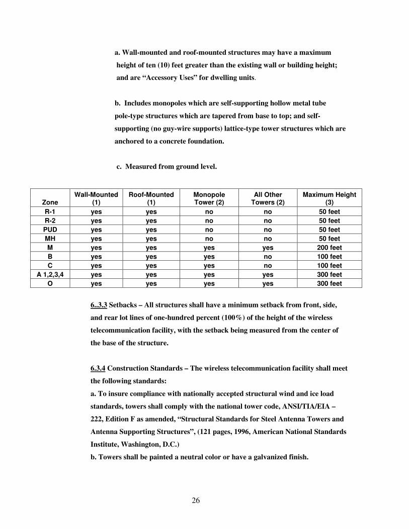
6..3.2 Location and Height – The following table specifies where wireless
telecommunication facilities are permitted and their maximum height:
26
a. Wall-mounted and roof-mounted structures may have a maximum
height of ten (10) feet greater than the existing wall or building height;
and are “Accessory Uses” for dwelling units.
b. Includes monopoles which are self-supporting hollow metal tube
pole-type structures which are tapered from base to top; and self-
supporting (no guy-wire supports) lattice-type tower structures which are
anchored to a concrete foundation.
c. Measured from ground level.
Zone Wall-Mounted
(1) Roof-Mounted
(1) Monopole Tower (2)
All Other Towers (2)
Maximum Height (3)
R-1 yes yes no no 50 feet
R-2 yes yes no no 50 feet
PUD yes yes no no 50 feet
MH yes yes no no 50 feet
M yes yes yes yes 200 feet
B yes yes yes no 100 feet
C yes yes yes no 100 feet
A 1,2,3,4 yes yes yes yes 300 feet
O yes yes yes yes 300 feet
6..3.3 Setbacks – All structures shall have a minimum setback from front, side,
and rear lot lines of one-hundred percent (100%) of the height of the wireless
telecommunication facility, with the setback being measured from the center of
the base of the structure.
6.3.4 Construction Standards – The wireless telecommunication facility shall meet
the following standards:
a. To insure compliance with nationally accepted structural wind and ice load
standards, towers shall comply with the national tower code, ANSI/TIA/EIA –
222, Edition F as amended, “Structural Standards for Steel Antenna Towers and
Antenna Supporting Structures”, (121 pages, 1996, American National Standards
Institute, Washington, D.C.)
b. Towers shall be painted a neutral color or have a galvanized finish.
27
c. Accessory equipment buildings shall meet setback, height and sign regulations
of the zone district in which located.
6.3.5 Tower Spacing – Towers which exceed one-hundred (100) feet in height shall
be located at least six (6) miles from other towers which exceed one-hundred (100)
feet in height.
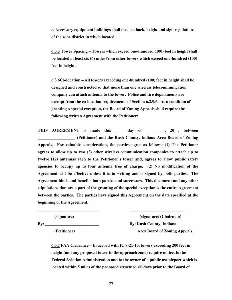
6.3.6Co-location – All towers exceeding one-hundred (100) feet in height shall be
designed and constructed so that more than one wireless telecommunication
company can attach antenna to the tower. Police and fire departments are
exempt from the co-location requirements of Section 6.2.9.6. As a condition of
granting a special exception, the Board of Zoning Appeals shall require the
following written Agreement with the Petitioner:
THIS AGREEMENT is made this ____ day of _________, 20__, between
__________________ (Petitioner) and the Rush County, Indiana Area Board of Zoning
Appeals. For valuable consideration, the parties agree as follows: (1) The Petitioner
agrees to allow up to two (2) other wireless communication companies to attach up to
twelve (12) antennas each to the Petitioner’s tower and, agrees to allow public safety
agencies to occupy up to four antenna free of charge. (2) No modification of the
Agreement will be effective unless it is in writing and is signed by both parties. The
Agreement binds and benefits both parties and successors. This document and any other
stipulations that are a part of the granting of the special exception is the entire Agreement
between the parties. The parties have signed this Agreement on the date specified at the
beginning of the Agreement.
_____________________________ __________________________
(signature) (signature) (Chairman)
By: __________________________ By: Rush County, Indiana
(Petitioner) Area Board of Zoning Appeals
6.3.7 FAA Clearance – In accord with IC 8-21-10, towers exceeding 200 feet in
height (and any proposed tower in the approach zone) require notice, to the
Federal Aviation Administration and to the owner of a public use airport which is
located within 5 miles of the proposed structure, 60 days prior to the Board of

28
Zoning Appeals Hearing. The Petitioner shall submit a copy of the Federal
Aviation Administration Form 7460-1 (notice of Proposed Construction or
Alteration) and if required by the FAA, shall install warning lights.
6.3.8 Fencing – The wireless telecommunication facility shall be enclosed by a
chain link metal fence at least seven (7) feet high, and shall be grounded in
compliance with the National Electrical Safety Code. The security fencing shall
include a vehicular gate. Wireless telecommunication facilities which are wall or
roof-mounted are exempt from fencing requirements.
6.3.9 Tower Removal – When the use of a wireless telecommunication facility has
been discontinued or abandoned for twelve consecutive months, the owner shall
have it removed within ninety (90) days of such cessation. Failure to remove the
abandoned wireless telecommunication facility shall constitute a violation of the
zoning ordinance.
6.3.10 Agencies that provide emergency services to the public are exempt from the
requirements of 6.2.9.2, 6.2.9.3, and 6.2.9.5.
Zones
Code # Category
R 1
R 2 M H
C
B
M
PUD
A-1 A-1R
A-2
A-3
A-4
O
470
Wireless Telecommunication Facilities
P
P P
X
X
X
P
X X
X
X X
X
480 Wind Energy Conversion Systems
X
X X
X
X
X
X
X X
X
X X
X
6.4 Wind Energy Conversion Systems Siting Regulations
6.4.1 Purpose: The purposes of this Chapter are to:
a. Assure that any development and production of wind-generated electricity
in Rush County is safe and effective;
b. Facilitate economic opportunities for local residents; and c. Promote the supply of wind energy in support of Indiana’s alternative energy sources potential and other such economic development tools. 6.4.2 Intent: It is the intent of the Wind Energy Conversion Systems (WECS) siting regulations to provide a regulatory scheme for the construction and

29
operation of WECS in the county; subject to reasonable restrictions these regulations are intended to preserve the health and safety of the public.
6.4.3 Applicability The provisions of this Chapter are applicable to those districts which allow wind energy conversion systems (WECS), govern the siting of WECS and substations that generate electricity to be sold to wholesale or retail markets, or that generate electricity for private use. A reasonable attempt shall be made to notify all property owners within the defined area of the WECS project prior to making application for a WECS permit. Notification may be done by media, separate mailings, or through the public notice requirements prescribed by IC 5-3-1 as amended from time to time. Said notice shall inform land owners of the intent to build a Commercial WECS and/or wind farm.
6.4.4 Prohibition No applicant shall construct, operate, or locate a wind energy conversion system (WECS) within Rush County without having fully complied with the provisions of this Chapter.
6.4.5 Conflict with Other Regulations Nothing in this Chapter is intended to preempt other applicable state and federal laws or regulations, including compliance with all Federal Aviation Administration rules and regulations and shall comply with the notification requirements of the FAA. Nor are they intended to interfere with, abrogate, or annul any other ordinance, rule, or regulation, statute or other provision of law. In the event that any provision of these regulations imposes restrictions different from any other ordinance, rule, regulation, statute, or provision of law, the provisions that are more restrictive or that imposes higher standards shall govern.
A: DEFINITIONS
1. APPLICANT: means the entity or person who submits to the Executive
Director an application for the siting of any WECS or Substation or thereafter operates or owns a WECS.
2. FINANCIAL ASSURANCE: means reasonable assurance from a creditworthy
party, examples of which include a surety bond, trust instrument, cash escrow, or irrevocable letter of credit or combinations thereof.
3. OPERATOR: means the entity responsible for the day-to-day operation on
maintenance of the WECS, including any third party subcontractors. 4. OWNER: means the entity or entities with an equity interest in the WECS(s),
including their respective successors and assigns. Owner does not mean (i) the property owner from who the land is leased for locating the WECS (unless the property owner has an equity interest in the WECS); or (ii) any person holding a security interest in the WECS(s) solely to secure an extension of credit, or a person foreclosing on such security interest provided that after foreclosure, such person seeks to sell the WECS(s) within one year of such event.

30
5. PROFESSIONAL ENGINEER: means a qualified individual who is licensed as
a professional engineer in any state in the United States. 6. PRIMARY STRUCTURE: means, for each property, the structure that one (1)
or more persons occupy the majority of the time on that property for either business or personal reasons. Primary Structure includes structures such as residences, commercial buildings, hospitals, and day care facilities. Primary Structure excludes structures such as hunting sheds, storage sheds, pool houses, unattached garages and barns.
7. SUBSTATION: means the apparatus that connects the electrical collection
system of the WECS(s) and increases the voltage for connection with the utility’s transmission lines.
8. SWITCHING STATION: shall be an apparatus/structure in the system similar
to a substation but not necessarily increasing voltage into the grid. 9. WECS PROJECT: means the collection of WECSs and Substations as
specified in the siting approval application. 10. WECS TOWER: means the support structure to which the nacelle and rotor
are attached, free standing or guyed structure that supports a wind turbine generator.
11. WECS TOWER HEIGHT: means the distance from the rotor blade at its
highest point to the top surface of the WECS foundation. 12. WIND ENERGY CONVERSION SYSTEM (“WECS”): means all necessary
devices that together convert wind energy into electricity and deliver that electricity to a utility’s transmission lines, including but not limited to the rotor, nacelle, generator, WECS Tower, electrical components, WECS foundation, transformer, electrical cabling for the WECS Tower to the Substation(s), switching stations, meteorological towers, communications facilities, and other required facilities and equipment, as related to the WECS project.
(A) Commercial WECS is defined for the purposes of the Rush County Zoning Ordinance to mean a wind energy system constructed on the property of another by a company or corporation or other entity, whose general intent is to capture wind energy and place it on the electrical grid for resale to a utility. (B) Non-Commercial WECS is defined as a wind energy collection system that is generally smaller than a commercial WECS and the primary purpose is to collect wind energy for purpose of supplying energy to the owners, such

31
as a business, school, or factory.
(C) Micro-WECS is defined as a small wind energy collection system whose general purpose is to provide energy to a residential or small business user such as a farmer or homeowners.

32
6.4.6 District Regulation
6.4.6.1 Location: Commercial, non-commercial, and micro-WECS will be permitted, or not permitted, in various districts as prescribed by the Official Schedule of Uses (Appendix E).
6.4.6.2 Height: Any Non-Commercial WECS or meteorological tower greater than two hundred (200) feet in height shall require a special exception use permit. For Commercial WECS there is no limitation on height, except those height limitations imposed by FAA rules and regulations. No Micro-WECS shall exceed sixty (60) feet in height.
6.4.6.3 Horizontal extension: The furthest horizontal extension of a WECS (including guy wires) shall not extend into a required setback by the zoning district or be closer than twelve (12) feet to any primary structure, or right-of-way easement for any above-ground telephone, electrical transmission or distribution lines.
6.4.6.4 Setback Requirements
6.4.6.4.1 Minimum setback distances for Commercial WECS
(Wind Energy Conversion Systems)
Distance from a… Minimum Setback Distance
Property line, measured from the center of the WECS to the property line
1.1 times the total height (where the blade tip is at its highest point) for non-participating landowners. The setback requirement may be waived, in writing, by participating landowners.
Residential dwellings, measured from the center of the WECS to the nearest corner of the structure
One thousand (1,000) feet for non-participating landowners.1 The setback requirement may be waived, in writing, by participating landowners.
Road right-of-way, measured from the center of the WECS to the edge of the right-of-way
1.1 times the total height (where the blade tip is at its highest point), provided that the distance is no less than three hundred and fifty (350) feet2
Other rights-of-way, such as railroads and utility easements, measured from the center of the WECS to the edge of the right-of-way
1.1 times the total height (where the blade tip is at its highest point), provided that the distance is no less than three hundred and fifty (350) feet
33
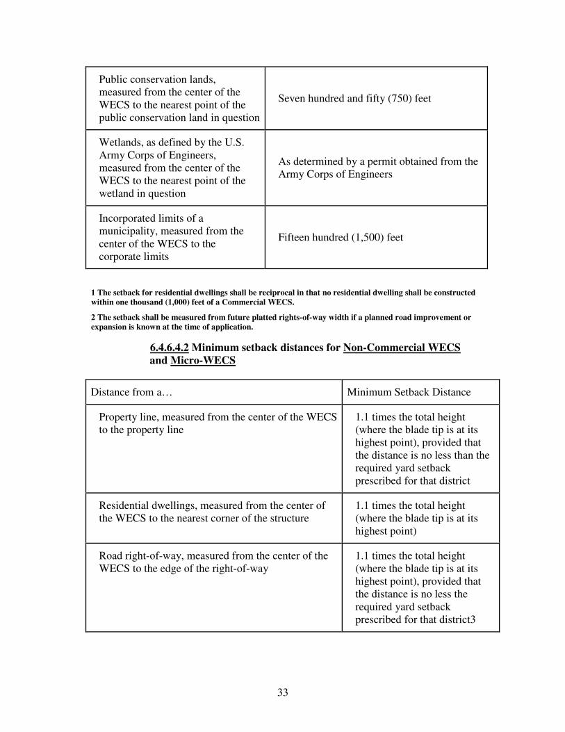
Public conservation lands, measured from the center of the WECS to the nearest point of the public conservation land in question
Seven hundred and fifty (750) feet
Wetlands, as defined by the U.S. Army Corps of Engineers, measured from the center of the WECS to the nearest point of the wetland in question
As determined by a permit obtained from the Army Corps of Engineers
Incorporated limits of a municipality, measured from the center of the WECS to the corporate limits
Fifteen hundred (1,500) feet
1 The setback for residential dwellings shall be reciprocal in that no residential dwelling shall be constructed within one thousand (1,000) feet of a Commercial WECS.
2 The setback shall be measured from future platted rights-of-way width if a planned road improvement or expansion is known at the time of application.
6.4.6.4.2 Minimum setback distances for Non-Commercial WECS and Micro-WECS
Distance from a… Minimum Setback Distance
Property line, measured from the center of the WECS to the property line
1.1 times the total height (where the blade tip is at its highest point), provided that the distance is no less than the required yard setback prescribed for that district
Residential dwellings, measured from the center of the WECS to the nearest corner of the structure
1.1 times the total height (where the blade tip is at its highest point)
Road right-of-way, measured from the center of the WECS to the edge of the right-of-way
1.1 times the total height (where the blade tip is at its highest point), provided that the distance is no less the required yard setback prescribed for that district3
34
Other rights-of-way, such as railroads and utility easements, measured from the center of the WECS to the edge of the right-of-way
1.1 times the total height (where the blade tip is at its highest point), provided that the distance is no less than the required yard setback prescribed for that district
Public conservation lands, measured from the center of the WECS to the nearest point of the public conservation land in question
Seven hundred and fifty (750) feet
Wetlands, as defined by the U.S. Army Corps of Engineers, measured from the center of the WECS to the nearest point of the wetland in question
As determined by a permit obtained from the Army Corps of Engineers
3 The setback shall be measured from future rights-of-way width if a planned road improvement or expansion is known at the time of application.
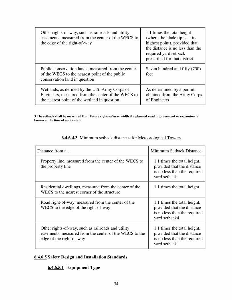
6.4.6.4.3 Minimum setback distances for Meteorological Towers
Distance from a… Minimum Setback Distance
Property line, measured from the center of the WECS to the property line
1.1 times the total height, provided that the distance is no less than the required yard setback
Residential dwellings, measured from the center of the WECS to the nearest corner of the structure
1.1 times the total height
Road right-of-way, measured from the center of the WECS to the edge of the right-of-way
1.1 times the total height, provided that the distance is no less than the required yard setback4
Other rights-of-way, such as railroads and utility easements, measured from the center of the WECS to the edge of the right-of-way
1.1 times the total height, provided that the distance is no less than the required yard setback
6.4.6.5 Safety Design and Installation Standards
6.4.6.5.1 Equipment Type
35
A. Turbines: ALL turbines shall be constructed of commercially available equipment.
B. Meteorological towers: Meteorological towers may be guyed.
C. Experimental, or proto-type equipment: Experimental or proto-type equipment still in testing which does not fully comply with industry standards, may be approved by the Board of Zoning Appeals per the variance process established by this Ordinance.
6.4.6.5.2 Industry Standards and other Regulations
All WECS shall conform to applicable industry standards, as well as all local, state and federal regulations. An applicant shall submit certificate(s) of design compliance that wind turbine manufacturers have obtained from Underwriters Laboratories, Det Norske Veritas, Germanishcher Lloyed Wind Energie, or an equivalent third party.
6.4.6.5.3 Controls and Brakes
A. Braking system: All WECS shall be equipped with a redundant braking system. This includes both aerodynamic over speed controls (including variable pitch, tip, and other similar systems) and mechanical brakes. Stall regulation shall not be considered a sufficient braking system for over speed protection.
B. Operation mode: All Mechanical brakes shall be operated in a fail-safe mode.
6.4.6.5.4 Electrical Components
A. Standards: All electrical components of all WECS shall conform to applicable local, state and national codes, and any relevant national and international standards.
B. Collection cables: All electrical collection cables between each WECS shall be located underground wherever possible.
C. Transmission lines: All transmission lines that are buried should be at a depth consistent with or greater than local utility and telecommunication underground lines standards or as negotiated with the land owner or the land owner’s designee until the same reach the property line or a substation adjacent to the property line.
6.4.6.5.5 Color and Finish
In addition to all applicable FAA requirements, the following shall also apply:

36
A. Wind turbines and towers: All wind turbines and towers that are part of WECS shall be white, grey, or another non-obtrusive color.
B. Blades: All blades shall be white, grey, or another non-obtrusive color. Blades may be black in order to facilitate deicing.
C. Finishes: Finishes shall be matte or non-reflective.
D. Variances: Variances may be granted by the Board of Zoning Appeals for meteorological towers, where concerns exist relative to aerial spray applicators.
6.4.6.5.6 Warnings
A. Towers, Transformers, and Substations:
For all Commercial WECS, a sign or signs shall be posted on the tower, transformer and substation warning of high voltage. Signs with emergency contact information shall also be posted on the turbine or at another suitable point.
B. Guy Wires and Anchor Points:
For all guyed towers, one of the following warning mechanisms shall be used for each anchor point:
1. Visible or reflective objects: Visible and reflective objects, such as flags, plastic sleeves, reflectors, or tape placed on the anchor points of guy wires and along the innermost guy wires up to eight (8) feet above the ground.
2. Visible Fencing: Visible fencing not less than four (4) feet in height installed around anchor points of guy wires.
C. Non-commercial WECS and Micro-WECS
The following notices shall be clearly visible on all Non-commercial WECS, and Micro-WECS towers and accessory facilities:
1. “No Trespassing” signs shall be attached to any perimeter
fence.
2. “Danger” signs shall be posted at the height of five (5) feet on WECS towers and accessory structures 3. A sign shall be posted on the tower showing an emergency telephone number 4. The manual electrical and/or overspeed shutdown disconnect switch(es) shall be clearly labeled.
D. Meteorological Towers
37
Consideration shall be given to paint aviation warning on all meteorological towers.
6.4.6.5.7 Climb Prevention All Commercial WECS tower designs shall include features to deter climbing or be protected by anti-climbing devices such as: A. Fences with locking portals at least six (6) feet in height; or B. Anti-climbing devices fifteen (15) feet vertically from the base of the WECS tower; or C. Locked WECS tower doors.
6.4.6.5.8 Blade Clearance
The minimum distance between the ground and any protruding blades(s) utilized on all Commercial WECS shall be twenty-five (25) feet, as measured at the lowest point of the arc of the blades. The minimum distance between the ground and any protruding blade(s) utilized on all remaining WECS shall be a minimum of fifteen (15) feet, as measured at the lowest point of the arc of the blades, provided the rotor blade does not exceed 20 feet in diameter. In either instance, the minimum distance shall be increased as necessary to provide for vehicle clearance in locations where over-sized vehicles might travel.
6.4.6.5.9 Lighting
A. Intensity and Frequency:
All lighting, including lighting intensity and frequency of strobe, shall adhere to but not exceed requirements established by Federal Aviation Administration permits and regulations.
B. Shielding
Except with respect to lighting required by the FAA, lighting may require shielding so that no glare extends substantially beyond any WECS structure.
6.4.6.5.10 Materials Handling, Storage and Disposal
A. Solid wastes
All solid wastes whether generated from supplies, equipment, parts, packaging, operation or maintenance of the facility, including old parts and equipment related to the construction, operation and/or maintenance of any WECS shall be removed from the site promptly and disposed of in accordance with all federal, state, and local laws.
B. Hazardous Materials

38
All hazardous materials or waste related to the construction, operation and/or maintenance of any WECS shall be handled, stored, transported and disposed of in accordance with all applicable local, state and federal laws.
6.4.7 Other Applicable Standards
6.4.7.1 Guyed Wire Anchors
No guyed wire anchors shall be allowed within any required road right-of-way setback.
6.4.7.2 Sewer and water
All WECS facilities shall comply with the existing septic and well regulations as required by the Rush County Health Department and/or the State of Indiana Department of Public Health.
6.4.7.3 Noise and Vibration
The noise level of Non-Commercial WECS shall be no greater than sixty (60) decibels measured from the nearest residence. This level may only be exceeded during short-term events such as utility outages and/or severe wind storms. All other noise and vibration levels shall be in compliance with all county, state and federal regulations.
6.4.7.4 Utility Interconnection
The WECS, if interconnected to a utility system, shall meet the requirements for interconnection and operate as prescribed by the applicable regulations of the electrical utility, as amended from time to time.
6.4.7.5 Signage
In addition to complying with Chapter 10, Sign Standards, the following signage regulations and standards shall also apply. In the event that one of the following regulations or standards conflicts with another sign regulation or standard prescribed by this ordinance, the most restrictive regulation or standard shall apply.
A. Surface area
No sign shall exceed sixteen (16) square feet in surface area.
B. Height
No sign shall exceed eight (8) feet in height.
C. Manufacturer’s or owner’s company name and/or logo
The manufacturers or owner’s company name and/or logo may be placed upon the compartment containing the electrical equipment.
39
D. Development signs
An identification sign relating to the wind farm development may be located on each side of the total project area, provided that there are no more than four (4) signs located on any one project site.
E. Other signs and logos
No other advertising signs or logos shall be placed or painted on any WECS.
6.4.7.6 Feeder lines
With the exception of minimum setback distances, feeder lines installed as part of any WECS shall not be considered an essential service. To wit, all communications and feeder lines installed as part of any WECS shall be buried underground wherever possible.
6.4.7.7 Other Appurtenances
No appurtenances other than those associated with the wind turbine operations shall be connected to any wind tower except with express, written permission by the Board of Zoning Appeals.
6.4.8 Operation and Maintenance
6.4.8.1 Physical Modifications
In general, any physical modification to any WECS that alters the mechanical load, mechanical load path, or major electrical components shall require re-certification. Like-kind replacements shall not require re-certification. Therefore, prior to making any physical modification, the owner or operator shall confer with the Executive Director and Board of Zoning Appeals to determine whether the physical modification requires re-certification.
6.4.8.2 Interference
Prior to construction, a communications study to minimize interference with public or public serving utility microwave transmissions shall be completed. If necessary, the applicant, owner and/or operator shall mitigate interference with electromagnetic communications, such as radio, telephone, microwaves, or television signals caused by any WECS. In addition, the applicant, owner, and/or operator shall comply with the following:
A. Pre-construction
The applicant shall complete a communications study prior to construction so as to minimize interference with any public or public serving utility microwave transmissions.
B. Post-construction
If, after construction of the WECS, the Executive Director, the owner or operator receives a written complaint related to interference with

40
the broadcast of residential television, telecommunication, communication or microwave transmissions, the owner or operator shall take reasonable steps to mitigate said interference. Interference with private telecommunications systems such as GPS shall be between the company and the complainant.
C. Failure to remedy a complaint
If an agreement to remedy a known interference is not reached within ninety (90) days, appropriate action will be taken by the Executive Director, which may result in requiring the WECS to become inactive. This does not apply to interference with private telecommunications systems.
6.4.8.3 Declaration of Public Nuisance
Any WECS thereof declared to be unsafe by the Rush County Executive Director by reason of inadequate maintenance, dilapidation, obsolescence, fire hazard, damage or abandonment is hereby declared to be a public nuisance and shall be abated by repair, rehabilitation, demolition or removal in accordance with the approved Decommissioning Plan.
6.4.8.4 Decommissioning Plan
Prior to receiving an Improvement Location Permit or Building Permit, or siting approval under this Ordinance, the Board of Zoning Appeals and the applicant, owner and/or operator shall formulate a decommissioning plan outlining the anticipated means and cost of removing a WECS at the end of their serviceable life or upon becoming a discontinued or abandoned use to ensure that the WECS is properly decommissioned.
6.4.8.4.1 Content
A decommissioning plan shall include, at a minimum, language to the following:
A. Assurance: Written assurance that the facilities will be properly decommissioned upon the project life or in the event that the facility is abandoned.
B. Cost estimates: The applicant shall provide a contractor cost estimate for demolition and removal of the WECS facility which cost estimate shall include any offsetting affects of salvage value. The cost estimates shall be made by a competent party: such as a professional engineer, a contractor capable of decommissioning or a person with suitable expertise or experience with decommissioning WECS.
C. Financial assurance: Applicant will provide financial assurance in an amount at least equal to said demolition and removal contractor cost estimate, through the use of a bond, letter of credit or other security acceptable to the County, for the cost of decommissioning each tower and related improvements constructed under the permit.
41
Said security will be released when each tower is properly decommissioned as determined by the Executive Director.
6.4.8.4.2 Discontinuation and Abandonment
A. Discontinuation: All WECS shall be considered a discontinued use after one (1) year without energy production, unless a plan is developed and submitted to the Executive Director outlining the steps and schedule for returning the WECS to service.
B. Abandonment by the owner or operator: In the event of abandonment by the owner or operator, the applicant will provide an affidavit to the Executive Director representing that all easements for wind turbines shall contain terms that provide financial assurance, including access to the salvage value of the equipment, for the property owners to ensure that facilities are properly decommissioned within one (1) year of expiration or earlier termination of the project.
6.4.8.4.3 Removal
An applicant’s obligations shall include removal of all physical material pertaining to the project improvements to no less than a depth of four (4) feet below ground level within three hundred sixty-five (365) days of the discontinuation or abandonment of the facility, and restoration of the project area to as near as practicable the condition of the site immediately before construction of such improvements by the owner, (unless otherwise agreed to by the property owner) or by Rush County at the owner’s expense.
6.4.8.4.4 Written Notices
Prior to implementation of the existing procedures for the resolution of such default(s), the Executive Director shall first provide written notice to the owner and/or operator, setting forth the alleged default(s). Such written notice shall provide the owner and/or operator a reasonable time period not to exceed sixty (60) days, for good faith negotiations to resolve the alleged default(s).
6.4.8.4.5 Costs Incurred by the County
If the County removes a tower and appurtenant facilities, it may sell the salvage to defray the costs of removal. By approval, the permittee or grantor grants a license to Rush County to enter the property to remove a tower pursuant to the terms of an approved decommissioning plan.
6.4.9 Liability Insurance
The owner or operator of any WECS shall maintain a current general liability policy covering bodily injury and property damage and shall be required to name Rush County as an additional insured with dollar
42
amount limits per occurrence, in the aggregate, and a deductible, which is suitable to the County.
6.4.10 Application Procedures
In accord with Appendix E, application shall be made to the Board of Zoning Appeals for a Special Exception. Permits and variances shall be applied for and reviewed under the procedures established by this Ordinance, except that the application for a commercial WECS Improvement Location Permit shall also include the following information:
6.4.10.1 Applications for All Wind Energy Conversion Systems
An application for ALL WECS shall include the following
information:
A. Contact information of project applicant: The name(s), address(es), and phone number(s) of the applicant(s), as well as a description of the applicant’s business structure and overall role in the proposed project.
B. Contact information of current project owner: The name(s), address(es), and phone number(s) of the owner(s), as well as a description of the owner’s business structure and overall role in the proposed project, and including documentation of land ownership or legal control of the property on which the WECS is proposed to be located. The Executive Director shall be informed of any changes in ownership.
C. Contact information of project operator: The name(s), address(es), and phone number(s) of the operator(s), as well as a description of the operator’s business structure and overall role in the proposed project.
D. Legal description: The legal description, address, and general location of the project.
E. Project description: A WECS Project Description, including to the extent possible, information on each wind turbine proposed, including:
1. Number of turbines; 2. Type; 3. Name plate generating capacity; 4. Tower height; 5. Rotor diameter; 6. Total height; 7. Anchor base; 8. The means of interconnecting with the electrical grid; 9. The potential equipment manufacturer(s); and

43
10. All related accessory structures.
F. A Site Layout Plan: A site plan, drawn to scale5, including distances and certified by a registered land surveyor.
G. Engineering Certification: For all WECS, the manufacturer’s engineer or another qualified registered professional engineer shall certify, as part of the building permit application that the turbine, foundation and tower design of the WECS is within accepted professional standards, given local soil and climate conditions. An engineering analysis of the tower showing compliance with the applicable regulations and certified by a licensed professional engineer shall also be submitted. The analysis shall be accompanied by standard drawings of the wind turbine structure, including the tower, base, and footings.
H. Proof of Correspondence and Cooperation with Wildlife Agencies: For the purposes of preventing harm to migratory birds and in compliance with the Migratory Bird Treaty Act, the applicant shall provide written documentation that he or she is in direct correspondence and cooperation with the U.S. Fish and Wildlife Service and the Indiana Department of Natural Resources. I. Plan Release from Fire Prevention and Building Safety The applicant for an WECS shall submit the application documents to the Indiana Fire Prevention and Building Safety Commission for certification that the WECS complies with the Uniform Building Code.
5 All drawings shall be at a scale not smaller than one inch equals fifty feet (1”=50’) with a scale of one inch equals thirty feet (“1=30’) being preferred. Any other scale must be approved by the Executive Director. No individual sheet or drawing shall exceed twenty-four inches by thirty-six inches (24” x 36”).
6 All drawings shall be at a scale not smaller than one inch equals fifty feet (1”=50’) with a scale of one inch equals thirty feet (“1=30’) being preferred. Any other scale must be approved by the Executive Director. No individual sheet or drawing shall exceed twenty-four inches by thirty-six inches (24” x 36”).
6.4.10.2 Applications for Non-Commercial Wind Energy Conversion Systems
In addition to the application requirements listed in 6.2.10.13, Applications for all Wind Energy Conversion Systems, applications for Non-Commercial WECS shall also include the following information:
A. Demonstration of Energy Need: The primary purpose of the production of energy from a Non-Commercial WECS shall be to serve the energy needs of that tract. The applicant(s) shall demonstrate how much energy is needed and how the proposed size and number of the WECS fulfills this need. Net-metering may be allowed, but shall not be the primary intent of the WECS.

44
B. Statement of FAA Compliance: A statement of compliance with all applicable FAA rules and regulations, including any necessary approvals for installations within close proximity to an airport.
C. Utility Notification: No Non-Commercial WECS shall be installed until evidence has been given that the local utility company has been informed of the customer’s intent to install an interconnected customer-owned generator. Off-grid systems shall be exempt from this requirement.
D. Compliance with National Electrical Code: A line drawing of the electrical components in sufficient detail to allow for a determination that the manner of installation conforms to the National Electrical Code. This information is frequently supplied by the manufacturer.
6.4.10.3 Applications for Commercial Wind Energy Conversion Systems
In addition to the application requirements listed in 6.2.10.13, Applications for all Wind Energy Conversion Systems, applications for Commercial WECS shall also include the following information:
A. A Preliminary Site Layout Plan: In place of the site layout plan described in 6.2.10.13.1(F) Applications for all Wind Energy Conversion Systems, an application for a Commercial WECS shall include a preliminary site layout plan with distances drawn to scale6 illustrating the following:
1. Property lines, including identification of adjoining
properties,
2. The latitude and longitude of each individual wind turbine, along with individual identification of each WECS.
3. Dimensional representation of the structural components of the tower construction including the base and footings
4. WECS access roads 5. Substations 6. Electrical cabling 7. Ancillary equipment 8. Primary structures within one quarter (1/4) mile of all proposed WECS 9. Required setback lines 10. Location of all public roads which abut, or traverse the proposed site 11. The location of all above-ground utility lines within a distance of two (2) times the height of any proposed WECS structure. 12. The location of any historic or heritage sites as recognized by the Division of Historic Preservation and Archeology of the

45
Indiana Department of Natural Resources, within one (1) mile of a proposed WECS 13. The location of any wetlands based upon a delineation plan prepared in accordance with the applicable U.S. Army Corps of Engineers requirements and guidelines, within one (1) mile of a proposed WECS 14. Any other item reasonably requested by the Board of Zoning Appeals.
a. Topographic map
b. USGS topographical map, or map with similar data, of the property and the surrounding area, including any other WECS within ten (10) rotor distance, but no less than a one quarter (1/4) mile radius from the proposed project site, with contours of not more than five (5) foot intervals.
c. Noise profile
d. Location of all known WECS within one (1) mile of the proposed WECS, including a description of the potential impacts on said WECS and wind resources on adjacent properties. e.. Copy of the Communications Study
6.4.10.4 Aggregated Project Applications
Aggregated projects may jointly submit a single application and be reviewed under joint proceedings, including notices, hearing, and reviews and as appropriate, approvals.
6.4.11 Fees
A. Commercial WECS, Non-Commercial WECS, Micro-WECS, and Meteorological Towers
As prescribed in Section 12 of this Ordinance: Fee Schedule.
7 All drawings shall be at a scale not smaller than one inch equals fifty feet (1”=50’) with a scale of one inch equals thirty feet (“1=30’) being preferred. Any other scale must be approved by the Executive Director.
B. Aggregated projects
Applications will be assessed fees for each construction phase within a single project, as prescribed in Section 12 of this Ordinance: Fee Schedule.
6.4.12 Permits
46
A. Commercial WECS, Non-Commercial WECS, Micro-WECS, and Meteorological Towers
As prescribed by Chapter 12, Administration, of this Ordinance.
B. Aggregated projects
Permits for aggregated projects will be issued by construction phases and recorded separately, as prescribed by Section 7. Administration and Enforcement, of this Ordinance.
6.4.13 Pre-Construction Requirements
Prior to the issuance of any Improvement Location Permit, the following shall be submitted to and reviewed by the Executive Director, who shall certify that the following are in compliance with all applicable regulations:
6.4.13.1 FAA permit application
6.4.13.2 Decommissioning Plan
A Decommissioning Plan as prescribed in 6.2.10.11 of this Chapter.
6.4.13.3 Economic Development, Drainage, and Road Use and Maintenance Agreements
An Economic Development Agreement, a Drainage Agreement, and a Road Use and Maintenance Agreement approved by the County Commissioners. The agreement shall be developed in conjunction with the Rush County Economic Development office. This agreement must be signed before any Improvement Location Permit is issued. The Drainage Agreement must prescribe or reference provisions to address crop and field tile damages.
6.4.13.4 Erosion Control Plan
An erosion control plan developed in consultation with the Natural Resources Conservation Services (NRCS), and any storm water quality management plan adopted by the applicable jurisdiction.
6.4.13.5 Utility Plan
A utility plan drawn to the same scale as the site plan illustrating the location of all underground utility lines associated with the total WECS project shall be submitted to Executive Director. No individual sheet or drawing shall exceed twenty-four inches by thirty-six inches (24” x 36”).
6.4.13.6 Final Site Layout Plan

47
Provide a copy of the Final Site Layout Plan illustrating the final location of all that is required in the preliminary site layout plan, as approved by the landowner.
6.4.13.7 Avoidance and Mitigation of Damages to Public Infrastructure
In addition to complying with the approved Road Use and Maintenance Agreement, an applicant, owner, or operator proposing to use any county road(s), for the purpose of transporting Commercial WECS or substation parts and/or equipment for construction, operation or maintenance of a Commercial WECS or substation, shall comply with the following pre-construction requirements.
A. Identification of roads and services
Identify all roads and services, to the extent that any proposed routes that will be used for construction and maintenance purposes shall be identified. If the route includes a public road, it shall be approved by the Rush County Highway Department.
B. Pre-construction survey
The applicant shall conduct a pre-construction baseline survey acceptable to the Highway Superintendent to determine existing road conditions for assessing potential future damage. The survey shall include photographs, or video, or a combination thereof, and a written agreement to document the condition of the public facility.
6.4.14 Construction Requirements
During construction, the applicant shall demonstrate that the following requirements are being met:
6.4.14.1 Dust Control
Reasonable dust control measures shall be required by the Board of Zoning Appeals during construction of a Commercial WECS.
6.4.14.2 Drainage
Reasonable storm water best management practices as required by the approved Drainage Plan/Agreement on file with the Rush County Surveyor.
6.4.15 Post-Construction Requirements
Post-construction, the applicant shall comply with the following provisions:
6.4.15.1 Road Repairs
48
Any road damage caused by the construction of project equipment, the installation of the same, or the removal of the same, shall be repaired to the satisfaction of the Rush County Highway Superintendent. The superintendent may choose to require either remediation of road repair upon completion of the project or are authorized to collect fees for oversized load permits. Further, a corporate surety bond in an amount to be fixed by a professional engineer may be required by the superintendent to insure the county that future repairs are completed to the satisfaction of the unit of local government. The cost of bonding is to be paid by the applicant.
6.4.15.2 As-Built Plans Requirement
Where upon completion of all development, the exact measurements of the location of utilities and structures erected during the development are necessary for public record and shall therefore be recorded. The applicant, owner, or operator shall submit a copy of the Final Construction Plans (as-built plans), as amended, to the Executive Director with the exact measurements thereon shown. The Building Inspector, after being satisfied that the measurements are substantially the same as indicated on the originally approved final plan(s), shall approve, date and sign said Construction Plans for the project, which the applicant, owner, or operator shall then record.
6.4.15.3 Change in Ownership
It is the responsibility of the owner or operator listed in the application to inform the Executive Director of all changes in ownership and operation during the life of the project, including the sale or transfer of ownership or operation.
SECTION 7. RESTRICTIONS PER DISTRICT
7.0 RESIDENTIAL DISTRICT (R1)
7.0.1 Intent – This district has been created to preserve and enhance a safe and
pleasant environment for the people of Rush County. It is intended to provide a
variety and mix of dwelling types and is an attempt to move away from single family
detached subdivisions flowing in an undifferentiated wave over the landscape. This
ordinance shall be interpreted as not being against single-family, detached housing,
but merely that it is not against other dwelling types and mixes and favors these
also, as other ordinances in the past have not.
49
7.0.2 Floor Area Ratio – Not to exceed .4.
7.0.3 Lot Area – Not less than 8,000 square feet per D.U. if connected to city water
and sewer; not less than one acre per D.U. if connected to a septic tank system. (As
amended effective 08-09-93
7.0.4 Lot Width – Not less than 70 feet.
7.0.5 Signs intended to be seen outside lot lines.
a. Non-illuminated business signs are permitted.
b. No sign shall project beyond a lot line, obstruct in any way a driver’s
vision of the road, or hinder his passage in any way.
c. No sign shall be placed so as to hinder or obstruct any pedestrian along
any pedestrian path.
d. No sign shall be larger than 4 sq. ft. per side.
e. Real Estate Signs
1. Size 7 ½ square feet per side
2. Temporary
7.0.6 Parking – 2 off street parking stalls shall be provided per D.U.
7.0.7 Visibility at Intersections – On a corner lot in any residential district,
nothing shall be erected, placed, planted or allowed to grow in such a
manner as materially to impede vision between a height of 2 ½ and 10 feet
above the centerline grades of the intersection streets, in the area bounded
by the street lines of such corner lots and a line joining points along the edge
of any yard, provided that no fence, wall, or hedge along the sides street line
50 feet from the point of the intersection.
7.0.8 Fences, Walls, and Hedges – Notwithstanding other provisions of this
ordinance, fences, walls, and hedges may be permitted in any required yard, or
along the sided or front edge of any front yard shall be over 4 feet in height.
However, a chain link or woven wire fence, that will not materially impede or
obstruct vision, may erect between a height of two and one half (2 ½) and ten (10)
feet.

50
7.0.9 Parking, Storage, or Use of Major Recreational Equipment -deleted 09/19/05.
7.0.10 Parking and Storage
Automotive vehicles or trailers of any kind or type without current license plates
shall not be parked or stored for more than 7 days on any residentially zoned
property other than in completely enclosed buildings with the exception of antique
vehicles. No residentially zoned property shall be used or maintained as a dumping
ground for rubbish, including but not limited to ; trash, garbage, metal, rope, bags
of paper, rags, glass, rubber, lumber, millwork, brick, or concrete blocks,; however,
such rubbish may be stored in a completely enclosed building or, may be kept in a
sanitary container for a maximum of 7 days.
7.0.11 Restrictions for 110: Household Units.
7.0.11.1
If built on a block or road where previous development has taken place:
a. Setbacks shall conform to within 10 feet either way of the average
setback of the D.U.’s located within 300 feet on each side of the said
D.U. along the same side of the same street or road, but shall in no
case be narrower than 25 feet.
b. Side yards shall conform to within 3 feet either way of the average
side yards of the D.U.’s on the block or side yards must conform to
within 3 feet either way of the average of the side yards of the D.U.’s
located within 300 feet on each side of said D.U. along the same side
of the same street or road, but shall in no case be narrower than 10
feet.
c. Rear yards shall be not less than 10 feet wide.
7.0.11.2
If built on a block or road where no previous residential development has
taken place:
a. Setbacks shall not be less than 30 feet from right-of-way line.
b. Side yards shall not be less than 10 feet wide. Side Yards
adjoining streets shall be not less than 30 feet wide.

51
c. Rear yards shall be not less than 10 feet wide.
d. For all side and rear yards:
1. For each full story above ground in excess of the ground
floor, increase minimum side and rear yard distances by 8
feet. A story which is more than half below ground level
from floor to ceiling shall be not considered a story for the
purpose of this ordinance.
EXAMPLE: A 2-story building shall have side and
rear yards at least 18 feet wide.
7.0.12 A mobile home may be permitted as a Temporary Special Exception
on a lot where a permanent dwelling unit exists and may be used by a blood
relative who requires nursing care from the resident of the existing dwelling
unit.
7.0.13 Restrictions for Special Exceptions (in addition to those specified in Section 9).
a. Restrictions for 111: Home Occupations
1. No structural additions are permitted on front or side of existing
D.U.
2. No more than 25% of the structure shall be used for non-
residential purposes.
3. Parking lots shall not exceed 4 stalls and shall not be within 30
feet of lot limits.
4. The occupation shall be conducted primarily by the resident of the
D.U. in which the activity is taking place.
5. No unsafe, uncomfortable, or offensive vibrations, noises, visual
effects, odors or air pollutants shall be allowed to radiate across
lot lines.
b. Restrictions for:
121: Rooming and Boarding Houses
124: Retirement Homes and Orphanages
125: Religious Quarters
130: Residential Hotels
1. Setbacks shall be not less than 30 feet from right-of-way
52
line
2. Side yards shall not be less than 30 feet wide.
3. Parking lots shall be placed behind or alongside the
principal buildings and shall be screened from the view of
the surrounding D.U.’s.
4. Parking areas shall not be located within 30 feet of lot
lines.
c. Restrictions for 470
refer to Section 6.2.9 Wireless Telecommunication Facilities
d. 480 Wind Energy Facilities
refer to Section 6.2.10 Wind Energy Conversion Systems
e. Restrictions for 481-484 (Utilities Substations)
1. No structure shall be placed within 30 feet of any lot line.
2. All structures erected, placed, or moved specifically for the
operation of the utility to which the lot is devoted shall be
completely surrounded or enclosed by a building or fence. A
fence shall be at least 7 feet high, in compliance with the
National Electric Safety Code.
3. No unsafe, uncomfortable, or offensive vibrations, noises,
visual effects, odors or air pollutants shall be allowed to
radiate across lot lines.
f. Restrictions for 651: Medical and other health services.
1. Facilities shall be located on a major street (any street
other than a local street as designated in Rush County
Comprehensive Plan or its revision).
2. Facilities shall be separated as mush as possible from
surrounding D.U.’s by streets, open space, fences and
vegetation.
3. No unsafe, uncomfortable or offensive vibrations, noises,
visual effects, odors, or air pollutants shall be allowed to
radiate across lot lines.
53
4. No structure or parking lot is permitted within 30 feet of
any lot line.
5. At least one parking stall per each five seats of waiting
room space.
g. Restrictions for 681 Nursery, Primary, and Secondary Education
1. Facilities shall be separated as much as possible from
surrounding D.U.’s by streets, open space, fences, and
vegetation.
2. No structure or parking lot shall be located within 30 feet
of any lot line.
RESIDENTIAL (R-1)
Permitted Uses 1. Dwelling unit 2. Freeways 3. Expressways 4. Parkways 5. Arterial Streets 6. Collector/Distributor Streets 7. Local Access Streets 8. Alleys 9. Automobile Parking 10. Playgrounds & Athletic Areas 11. Parks – General Recreation 12. Parks – Leisure & Ornamental Special Exceptions 1. Home Occupations 2. Rooming & Boarding Houses 3. Fraternity & Sorority Houses 4. Residents Halls or Dormitories 5. Retirement Homes & Orphanages 6. Religious Quarters

54
7. Other Group Quarters 8. Residential Hotels 9. Other Residential 10. Rapid Rail Transit & Street Railway Transportation 11. Other Highway and Street Right-of-Way 12. Telephone Communications (Local) 13. Telegraph Communications 14. Relay Towers & Transmitting Stations (TV and Radio) 15. Electric Utility 16. Gas Utility 17. Water Utilities and Irrigation 18. Wastewater Treatment Plant & Sewage Disposal 19. Retail – Grocers (with or without meat) 20. Retail – Meats and Fish 21. Retail – Fruits and Vegetables 22. Retail – Candy, Nut, Confectionery 23. Retail – Dairy Products 24. Retail – Bakeries 25. Retail – Other Food Trade 26. Retail – Eating Places 27. Retail – Drinking Places (alcoholic beverages) 28. Retail – Drug and Proprietary 29. Retail – Antiques and Secondhand Merchandise 30. Retail – Book and Stationery 31. Retail – Jewelry 32. Greenhouses 33. Banking and Bank-related Functions 34. Insurance Carriers, Agents, Brokers & Services 35. Real Estate and Related Services 36. Beauty & Barber Services 37. Funeral and Crematory Services 38. Cemeteries 39. Employment Services 40. Medical & Other Health Services 41. Legal Services 42. Sanitariums, Convalescent & Rest Home Services 43. Other Professional Services 44. Executive, Legislative & Judicial Functions 45. Protective Functions & their Related Activities 46. Postal Services 47. Nursery, Primary & Secondary Education 48. Religious Activities 49. Welfare & Charitable Services 50. Other Miscellaneous Services 51. Cultural Activities 52. Other Cultural Activities & Nature Exhibitions
55
53. Entertainment Assembly 54. Public Assembly, Misc. Purposes 55. Other Public Assembly 56. Sports Activities 57. Swimming Areas 58. Other Recreation (including camping & picnic areas) 59. Other Parks 60. Other Cultural, Entertainment & Recreational 61. Farms (predominately crop – Fibers) 62. Farms (predominately crop – Cash Grain) 63. Farms (Field Crops other than fiber or cash grain crops) 64. Wind Energy Conversion Systems
7.1 RESIDENTIAL DISTRICT (R 2) Added Effective 09-05-2006
7.1.1 Intent – The district has been created for the purpose of providing suburban size lots for single family dwelling units in areas adjacent to cities and towns. 7.1.2 Floor Area ratio – Not to exceed 0.4. 7.1.3 Lot Area – Not less than 20,000 square feet per Dwelling Unit. Lot must be connected to a municipal sanitary sewer collection system, a
municipal storm sewer and, to a public water supply system in accord with 327 IAC 3, 327 IAC 5, and 327 IAC 8 (Indiana Administrative Code).
Individual wells and septic tanks are prohibited; however, in the Western Rush County Regional Water & Sewer District and, in the Mays-Raleigh area where a public water supply system is not available, a community well or individual wells may be utilized. The subdivider may provide a “package wastewater treatment plant” and a certified operator or, may enter into an agreement with the municipality for the cost of wastewater treatment. 7.1.4 Lot width – Not less than 100 feet. 7.1.5 Signs intended to be seen outside lot lines: a. Non-illuminated business signs are permitted. b. No sign shall project beyond a lot line, obstruct in any way a driver’s vision of the road, or hinder his passage in any way. c. No sign shall be placed so as to hinder or obstruct any pedestrian along any pedestrian path. d. No sign shall be larger than 4 square feet per side. e. Real Estate Signs:

56
1. Size 7 ½ square feet per side. 2.Temporary. 7.1.6 Parking – 2 off-street parking stalls shall be provided per Dwelling Unit. 7.1.7 Visibility at Intersections – On a corner lot in any residential district, nothing shall be erected, placed, planted, or allowed to grow in such a manner as materially to impede vision between a height of 2 ½ and 10 feet above the centerline grades of the intersection streets, in the area bounded by the street lines of such corner lots and a line joining points along said street line 50 feet from the point of the intersection. 7.1.8 Fences, Walls, and Hedges – Notwithstanding other provisions of this ordinance, fences, walls and hedges may be permitted in any required yard, or along the edge of any yard, provided that no fence, wall or hedge along the sides or front edge or any front yard shall be over 4 feet in height. However, a chain link or woven wire fence, that will not materially impede or obstruct vision, may be erected between a height of 2 ½ and 10 feet. 7.1.9 Traffic Safety – To promote traffic safety, the subdivision shall comply with Title III, SECTION 3, item 2(a) of the Rush County Subdivision Control Ordinance which prohibits individual driveway access to a County Road. 7.1.10 Parking & Storage – Automotive vehicles or trailers of any kind or type without current license plates shall not be parked or stored for more than 7 days on any residentially zoned property other than in completely enclosed buildings with the exception or antique vehicles. No residentially zoned property shall be used or maintained as a dumping ground for rubbish, including but not limited to: trash, garbage, metal, rope, bags, paper, rags, glass, rubber, lumber, millwork, brick or concrete blocks; however, such rubbish may be stored in a completely enclosed building or, may be kept in a sanitary container for a maximum of 7 days. 7.1.11 Restrictions for 110: Dwelling Units. If built on a block or road where previous development has taken place: a. Setbacks shall conform to within 10 feet either way of the average setback of the Dwelling Units located within 300 feet on each side of the said Dwelling Unit along the same side of the same street or road, but shall in no case be narrower than 25 feet. b. Side yards shall conform to within 3 feet either way of the average side yards of the Dwelling Units on the block or side yards must conform to within 3 feet either way of the average of the side yards of the Dwelling Units located within 300 feet on each side of said

57
Dwelling Unit along the same side of the same street or road, but shall in no case be narrower than 10 feet. c. Rear yards shall be not less than 10 feet wide. 7.1.12 Restrictions for 110: Dwelling Units: If built on a block or road where no previous residential development has taken place: a. Setbacks shall be not less than 40 feet from right-of-way line. b. Side yards shall be not less than 10 feet wide. Side yards adjoining streets shall be not less than 30 feet wide. c. Rear yards shall be not less than 10 feet wide. d. For all side and rear yards: For each full story above ground in excess of the ground floor, increase minimum side and rear yard distances by 8 feet. A story which is more than half below ground level from floor to ceiling shall not be considered a story for the purpose of this ordinance. EXAMPLE: a 2-story building shall have side and rear yards at least 18 feet wide. 7.1.13 Restrictions for Special Exceptions a. Restrictions for 111: Home Occupations: 1. No structural additions are permitted on front or side of existing dwelling unit. 2. No more than 25% of the structure shall be used for non- residential purposes. 3. Parking lots shall not exceed 4 stalls and shall be not within 30 feet of lot limits. 4. The occupation shall be conducted primarily by the resident of the dwelling unit in which the activity is taking place. 5. No unsafe, uncomfortable, or offensive vibrations, noises, visual effects, odors or air pollutants shall be allowed to radiate across lot lines. b. Restrictions for: 124: Retirement Homes and Orphanages & 125: Religious Quarters 1. Setbacks shall not be less than 30 feet from right-of-way line. 2. Side yards shall not be les than 30 feet wide. 3. Parking lots shall be placed behind or alongside the principal buildings and shall be screened from the view of the surrounding dwelling units. 4. Parking areas shall not be located within 30 feet of lot lines. c. Restrictions for 470: Refer to Section 6.2.9 Wireless Telecommunication Facilities d. Restrictions for 480:

58
Refer to Section 6.2.10 Wind Energy Conversion Systems e. Restrictions for 481 to 483: (Utilities and Electric Substations) 1. No structure shall be placed within 30 feet of any lot line. 2. All structures erected, placed, or moved specifically for the operation of the utility to which the lot is devoted shall be completely surrounded or enclosed by a building or fence. A metal fence used to enclose electric supply stations shall be at least 7 feet high, and shall be grounded in compliance with the National Electrical Safety Code. 3. No unsafe, uncomfortable, or offensive vibrations, noises, visual effects, odors or air pollutants shall be allowed to radiate across lot lines. f. Restrictions for 681: Nursery, Primary and Secondary Education 1. Facilities shall be separated as much as possible from surrounding dwelling units by streets, open space, fences and vegetation. 2. No structure or parking lot shall be located within 30 feet of any lot line.
RESIDENTIAL – 2 (R-2) Permitted Uses 1. Dwelling Unit 2. Freeways 3. Expressways 4. Parkways 5. Arterial Streets 6. Collector/Distributor Streets 7. Local Access Streets 8. Alleys 9. Automobile Parking 10. Playgrounds & Athletic Areas 11. Parks – General Recreation 12. Parks – Leisure & Ornamental 13. Other Parks Special Exceptions 1. Home Occupations
59
2. Fraternity & Sorority Houses 3. Residents Halls or Dormitories 4. Retirement Homes & Orphanages 5. Religious Quarters 6. Rapid Rail Transit & Street Railway Transportation 7. Other Highway and Street Right-of-Way 8. Wireless Telecommunication Facilities 9. Telephone Communications (Local) 10. Telegraph Communications 11. Relay Towers & Transmitting Stations (TV and Radio) 12. Electric Utility 13. Gas Utility 14. Water Utilities and Irrigation 15. Wastewater Treatment Plant & Sewage Disposal 16. Cemeteries 17. Other Professional Services 18. Executive, Legislative & Judicial Functions 19. Protective Functions & their Related Activities 20. Postal Services 21. Nursery, Primary, & Secondary Education 22. Religious Activities 23. Welfare & Charitable Services 24. Other Miscellaneous Services 25. Cultural Activities 26. Other Cultural Activities & Nature Exhibitions 27. Entertainment Assembly 28. Public Assembly, Misc. Purposes 29. Other Public Assembly 30. Sports Activities 31. Swimming Areas 32. Other Recreation (including camping & picnic areas) 33. Other Cultural, Entertainment & Recreational 34. Farms (predominately crop – Fibers) 35. Farms (predominately crop – Cash Grain) 36. Farms (Field Crops other than fiber or cash grain crops) 37. Wind Energy Conversion Systems
7.2 PLANNED UNIT DEVELOPMENT DISTRICT (PUD) (Added
effective 05-18-2004)
7.2.1 Intent – The district has been created for the purpose of providing
Development flexibility and to encourage creative land planning and the

60
preservation of open space.
7.2.2 Rezoning Required-In accord with IC 36-7-4-1505, rezoning of the land tract
by the Area Plan Commission and the appropriate legislative body is required as
set forth in IC 36-7-4-602.
7.2.3 Filing Procedure – The Developer shall submit three copies of a preliminary
plan to the Area Plan Commission and the Board of Zoning Appeals. The
preliminary plan shall include:
a. Location and boundaries of the tract
b. Existing zoning of adjacent tracts
c. Proposed layout of streets, open space and lots.
d. Proposals for handling vehicular traffic.
e. Proposals to connect the development to a municipal sanitary sewer
collections system (in accordance with 327 IAC 3) and either a municipal
storm sewer system (in accordance with 327 IAC 5) or a Storm Water
Management Plan according to the Subdivision Control Ordinance
Title 3.4.5; or to connect to a public water supply system in accord with
327 IAC 8 (Indiana Administrative Code) if available.
f. Proposals to permanently reserve 15% of the total land area as open
space suitable for the common use of the public or the owners in the
development by covenant, dedication or easements. The land may be used
for forest preserve, recreational or open space.
g. Proposed covenants or commitments to be made a part of the
development.
h. Proposals to mitigate any adverse effects to adjoining property.
i. Proposed timetable for completing the development.
7.2.4 Preliminary Plan Hearing – Within twenty (20) days of the petitioner’s filing of the
Preliminary Development Plan, the Executive Director shall set a public hearing by
the Area Plan Commission and the Board of Zoning Appeals and after the hearings,
the Commission and the Board may approve, amend, or disapprove the plan and
may impose any reasonable condition upon its approval. If approved, the plan shall
be stamped “APPROVED PRELIMINARY PLANNED UNIT DEVELOPMENT
61
and shall be signed and dated by the President of the Commission and the Board.
The approved Preliminary Planned Unit Development shall then be certified to the
appropriate legislative body for adoption as a PUD District Ordinance in accord
with IC36-7-4-1512. Upon adoption by the legislative body, the Planned Unit
Development shall be returned to the Area Plan Commission which shall exercise
further jurisdiction pursuant to IC 36-7-4-1511.
7.2.6 Detailed Plan – Before any development occurs, the Developer shall prepare
detailed engineering plans showing the location of all streets, lots, utilities, building
setback lines, open space and other site development features in accord with Title
IV, Section 9 of the Subdivision Control Ordinance No. 1970-7 as amended.
The detailed plans shall be set for a public hearing by the Area Plan Commission.
Upon secondary review and a finding that the detailed plans are consistent with the
Approved Preliminary Planned Unit Development, the Area Plan Commission shall
grant secondary approval of the detailed plans which shall then be stamped
“APPROVED DETAILED PLANNED UNIT DEVELOPMENT” and which shall
be signed and dated by the President of the Commission.
7.2.7 Platting and Recording - In accord with IC 36-7-4-1513, the Approved Detailed
Planned Unit Development Plan shall qualify as the Secondary Plat required by the
Subdivision Control Ordinance No 1970-7 as amended and shall be the document
recorded by the county recorder. The Secondary Plat shall include covenants as
approved by the Area Plan Commission and shall provide for a property owners
association to own and manage the required open space and any private streets.
7.2.8 Bonding - In accord with IC 36-7-4-1512, the Developer shall comply with the
bonding requirements of Title IV, Section 10 of the Subdivision Control Ordinance
No 1970-7 as amended. Upon the furnishing of said bond, the Executive Director
may issue an Improvement Location Permit.
7.2.9 Expiration – In the event that the Detailed Plan required by Section 6.3.3.5 has not
been approved within one (1) year from the date of approval by the legislative body
of the Preliminary Plan required by Section 6.3.3.4, the Approved Preliminary
Planned Unit Development shall expire and the PUD rezoning shall be reclassified to

62
its prior zoning category. The Are Plan Commission may grant a one (1) time, one
(1) year extension of time to obtain secondary approval of the Detailed Plan.
7.2.10 Construction – Installation of improvement shall comply with the construction
Standards contained in the Title III, Section 4 of the Subdivision Control Ordinance
No. 1970-7 as amended. All construction must be completed within five (5) years of
the date of the Approved Detailed Planned Unit Development; otherwise, the
legislative body shall exercise its claim to the construction bonding.
7.2.11 Restrictions for Special Exceptions (in addition to those specified in Sec. 9)
a. Restrictions for 111:Home Occupations:
1. No more than 25% of the dwelling unit shall be used for non-
residential purposes.
2. The occupation shall be conducted primarily by the resident of
the dwelling unit in which the activity is taking place.
3. No unsafe, uncomfortable, or offensive vibrations, noises, visual
effects, odors, or air pollutants shall be allowed to radiate across
lot lines.
b. Restrictions for 124: Retirement Homes and Orphanages
125: Religious Quarters
1. Setbacks shall not be less than 40 feet from right-of-way line.
2. Side yards shall not be less than 30 feet wide.
3. Parking lots shall be placed behind or alongside the principal
buildings and shall be screened from the view of the surrounding
dwelling units.
4. Parking areas shall not be located within 30 feet of the lot lines.
c. Restrictions for 470: Refer to Section 6.2.9. Wireless Telecommunication
Facilities
d. Restrictions for 481 to 483: (Utilities and Electric Substations)
1. No structure shall be placed within 30 feet of any lot line.
2. All structures erected, placed, or moved specifically for the
Operation of the utility to which the lot is devoted shall be
Completely surrounded or enclosed by a building or fence. A
63
metal fence used to enclose electric supply stations shall be at least
7 feet high, and shall be grounded in compliance with the National
Electrical Safety Code.
3. No unsafe, uncomfortable, or offensive vibrations, noises, visual
effects, odors, or air pollutants shall be allowed to radiate across
lot lines.
e. Restrictions for 681: Nursery, Primary and Secondary Education
1. Facilities shall be separated as much as possible from
Surrounding dwelling units by streets, open spaces, fences and
vegetation.
2. No structure or parking lot shall be located within 30 feet of any
lot line.
PLANNED UNIT DEVELOPMENT DISTRICT (PUD) Permitted Uses 1. Dwelling 2. Freeways 3. Expressways 4. Parkways 5. Arterial Streets 6. Collector/Distributor Streets 7. Local Access Streets 8. Alleys 9. Automobile Parking 10. Wireless Telecommunication Facilities 11. Playgrounds & Athletic Areas 12. Parks – General Recreation 13. Parks – Leisure & Ornamental 14. Other Parks Special Exceptions 1. Home Occupations 2. Farm Dwelling Unit 3. Residents Halls or Dormitories 4. Retirement Homes & Orphanages 5. Religious Quarters 6. Rapid Rail Transit & Street Railway Transportation
64
7. Other Highway and Street Right-of-Way 8. Electric Utility 9. Gas Utility 10. Water Utilities & Irrigation 11. Nursery, Primary & Secondary Education 12. Religious Activities 13. Other Miscellaneous Services 14. Cultural Activities 15. Public Assembly, Misc. Purposes 16. Swimming Areas 17. Other Recreation (including camping & picnic areas) 18. Other Cultural, Entertainment & Recreational 19. Wind Energy Conversion Systems
7.3 MOBILE HOME DISTRICT (MH)
7.3.1 This district has been created to control the continued increase in mobile home
residences which this county has experienced, and restrict them to certain specific
areas.
7.3.2 Floor area ratio not to exceed .4.
7.3.3 No mobile home is permitted within 30 feet of lot lines of the mobile home
park or court.
7.3.4 All mobile homes shall be placed so that they can be moved and removed
individually without moving any other mobile home.
7.3.5 Signs intended to be viewed from outside the mobile home court:
a. One illuminated non-flashing sign is allowed per court, not to exceed 16
square feet in area.
65
7.3.6 If the mobile home court is designed to be occupied by 10 mobile homes or
more, not less that 15% of the gross land area of the court shall be improved for
recreational activities for the residents of the court.
7.3.7 Restrictions for Special Exceptions
a. Restrictions for 470 Refer to 6.2.9 Wireless Telecommunication Facilities
b. Restrictions for 480 Refer to 6.2.10 Wind Energy Conversion Systems
c. Restrictions for 481-484 (Utilities Substations)
1. See Section 6.3.1.14: Residential District Special Exceptions,
MOBILE HOME DISTRICT (MH) Permitted Uses 1. Mobile Home Parks or Courts 2. Automobile Parking 3. Playgrounds & Athletic Areas 4. Swimming Areas 5. Parks – General Recreation 6. Parks – Leisure & Ornamental Special Exceptions 1. Parkways 2. Arterial Streets 3. Collector/Distributor Streets 4. Local Access Streets 5. Alleys 6. Other Highway and Street Right-of-Way 7. Telephone Communications (Local) 8. Telegraph Communications 9. Electric Utility 10. Gas Utility 11. Water Utilities and Irrigation 12. Wastewater Treatment Plant & Sewage Disposal 13. Other Parks 14. Other Cultural, Entertainment & Recreational 15. Wind Energy Conversion Systems

66
7.4 MANUFACTURING DISTRICT (M)
7.4.1 This district has been created to set aside certain lands where manufacturing
uses may efficiently locate with a minimum of adverse effects to other uses in the
county. Certain harmful effluent have been limited in an attempt to avoid excessive
pollution.
7.4.2 Floor area ratio – not to exceed 1.
7.4.3 Lot area – not less than 10,000 sq. ft.
7.4.4 Any new industry shall provide a setback of at least 30 feet from right-of-way
lines.
7.4.5 Any new industry shall not build any structure other than parking lots and
fences or vision screening walls within 20 feet of any side or rear lot line.
7.4.6 Where any new industrial lot comes within 40 feet of a residential zone
boundary line, all uses shall be conducted within a building or within and area
enclosed on all sides with a solid wall, compact evergreen screen or uniformly
painted fence not less that 7 feet in height.
7.4.7 No manufacturing use structure, except fences and sign posts, shall come
within 35 feet of an R1, R2, PUD, or MH district boundary line.
7.4.8 At least one off-street parking stall shall be provided for each two workers.
7.4.9 Signs intended to be seen outside lot lines.
a. Illuminated business signs are permitted.
b. No sign shall project beyond a lot line, obstruct in any way a driver’s
vision of the road, or hinder his passage in any way.
c. No sign shall be placed so as to hinder or obstruct any pedestrian along
any pedestrian path.

67
D. No sign shall be larger than 50 square feet per side.
7.4.10 Performance Standards, as measured at the boundary lines of the “M”
district. All Standards are maximums. Manufacturing uses which exceed
these standards are considered to be in violation of this ordinance.
a. Performance Standards – Noise:
Sound levels shall be measured with a sound level meter and associated
octave band filter manufactured according to standards prescribed by the
American Standards Association. Measurements shall be made using the
flat network of the sound level meter. Impulsive type noises shall be subject
to the performance standards hereinafter prescribed, provided that such
noises shall be capable of being accurately measured with such equipment.
Noises capable of being so measured for the purpose of this ordinance shall
be those noises which cause rapid fluctuations of the needle of the sound
level meter, with a variation of no more than plus or minus two decibels.
Noises incapable of being so measured such as those of an irregular and
intermittent nature, shall be controlled so as not to become a nuisance to
adjacent uses. At no point on the boundary of the “M” District shall the
sound intensity level of any individual operation of plant (other than the
operation of motor vehicles or other transportation facilities) exceed the
decibel levels in the designated octave bands shown on the following table.
MAXIMUM PERMITTED SOUND
OCTAVE BAND FREQUENCY LEVEL IN DECIBELS
Cycles per second Resident Dist. Boundaries Business or Commercial Dist. Boundaries
0 to 75 72 75
75 to 150 67 70
150 to 300 59 63
300 to 600 52 57
600 to 1200 46 52
1200 to 2400 40 45
2400 to 4800 34 40
Above 4800 32 38
68
b. Performance Standards – Smoke and Particulate Matter:
The emissions of smoke or particulate matter in such a manner or
quantity as to endanger or to be detrimental to the public health,
safety, comfort, or welfare, is not permitted. For the purpose of
grading the density of smoke, the Ringelmann Chart, published and
used by the United States Bureau of Mines, shall be employed.
Large emission of smoke or particulate matter of a density greater
than No. 2 on the Ringelman Chart is prohibited at all times, except
as otherwise provided hereinafter. The emission, for all sources
within any lot area, of particulate matter containing more than ten
percent by weight of particles having a particle diameter larger than
44 microns is prohibited. Dust and other types of air pollution,
borne by the wind from such sources as storage area, yards, roads,
and the like, within lot boundaries, shall be kept to a minimum by
appropriate private landscaping, paving, oiling, fencing, or other
acceptable means. Emission of particulate matter from such sources
in excess of the weight limitation herein specified is prohibited.
Smoke:
The emission of more than eight smoke units per hour per stack is
prohibited, including smoke of a density in excess of Ringelmann No. 2.
However, during one one-hour period in each 24 hour day, each stack may
emit up to 1146 smoke units when blowing soot or cleaning fires. Only
during fire-cleaning periods, however, shall smoke of Ringelmann No. 3 be
permitted, and then for not more than three minutes.
c. Performance Standards – Toxic or Noxious Matter:
No use shall, for any period of time, discharge across the boundaries of the
lot wherein it is located toxic or noxious matter, such as sewage, in such
concentrations as to be detrimental to, or endanger the public health, safety,
comfort, or welfare, or cause injury or damage to property or business.
d. Performance Standards – Odors
The emission of odorous matter in such quantity as to be readily detectable
at any point along lot lines, or as to produce a public nuisance or hazard
beyond lot lines is prohibited.
e. Performance Standards – Fire and Explosion Hazard:

69
1. The storage, utilization or manufacture of materials, or products, ranging
from incombustible to moderate burning – as determined for liquids by a
closed cup flash point of not less that 187 degrees F – is permitted subject to
compliance with all other performance standards for the “M” District.
2. The storage, utilization, or manufacture of materials or products ranging
from free or active burning to intense burning - as determined for liquids by
a closed cup flash point of less than 187 degrees but not less than 105 degrees
Fahrenheit – is permitted, subject to compliance with all other performance
standards for the “M” District, and provided the following conditions are
met:
(i) Said materials or products shall be stored, utilized, or produced
within completely enclosed buildings or structures having
combustible exterior walls; and
(ii) All such buildings or structures shall be set back at least 40 feet
from lot lines, or, in lieu thereof, all such buildings or structures
shall be protected throughout by an automatic sprinkler system
complying with installation standards prescribed by the National
Fire Protection Association; or if the materials, goods, or products
are liquid, the protection thereof shall be in conformity with the
standards prescribed by the National Fire Protection Association.
3. The utilization in manufacturing processes of materials which produce
flammable or explosive vapors or gases – determined for liquids by a
closed cup flash point of less than 105 degrees F., shall be permitted in
this district provided:
(i) That the final manufactured product does not itself have closed
cup flash point of less than 187 degrees F.
(ii) That the use and storage of such materials shall be in conformity
with standards prescribed by the National Fire Protection
Association and the requirements of other ordinances of Rush
County.
(iii) That the storage of more than 50,000 gallons of materials or
products having a closed cup flash point of less than 105 degrees
Fahrenheit (exclusive of storage of finished products in original
sealed containers) is prohibited.
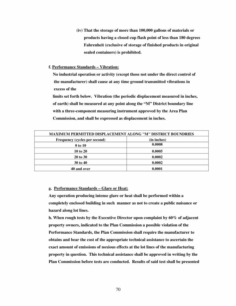
70
(iv) That the storage of more than 100,000 gallons of materials or
products having a closed cup flash point of less than 180 degrees
Fahrenheit (exclusive of storage of finished products in original
sealed containers) is prohibited.
f. Performance Standards – Vibration:
No industrial operation or activity (except those not under the direct control of
the manufacturer) shall cause at any time ground transmitted vibrations in
excess of the
limits set forth below. Vibration (the periodic displacement measured in inches,
of earth) shall be measured at any point along the “M” District boundary line
with a three-component measuring instrument approved by the Area Plan
Commission, and shall be expressed as displacement in inches.
MAXIMUM PERMITTED DISPLACEMENT ALONG "M" DISTRICT BOUNDRIES
Frequency (cycles per second) (in inches)
0 to 10 0.0008
10 to 20 0.0005
20 to 30 0.0002
30 to 40 0.0002
40 and over 0.0001
g. Performance Standards – Glare or Heat:
Any operation producing intense glare or heat shall be performed within a
completely enclosed building in such manner as not to create a public nuisance or
hazard along lot lines.
h. When rough tests by the Executive Director upon complaint by 60% of adjacent
property owners, indicated to the Plan Commission a possible violation of the
Performance Standards, the Plan Commission shall require the manufacturer to
obtains and bear the cost of the appropriate technical assistance to ascertain the
exact amount of emissions of noxious effects at the lot lines of the manufacturing
property in question. This technical assistance shall be approved in writing by the
Plan Commission before tests are conducted. Results of said test shall be presented
71
to the Plan Commission in writing. Any test result in excess of the appropriate
Performance Standard shall be considered a violation of the ordinance.
7.4.11 Restrictions for Special Exceptions
a. Restrictions for 470 Refer to 6.2.9 Wireless Telecommunication Facilities
b. Restrictions for 480 Refer to 6.2.10 Wind Energy Conversion Systems
c. Restrictions for 481-484: Utilities Substations
1. See Section 6.3.1.14: Residential District Special Exceptions,
Restrictions for 481-484 Utilities Substations.
d. Restrictions for 485: Solid Wastes Disposal and 486: Major Utilities,
Stations and Plants.
1. See Section 6.3.7.12: Commercial District Special Exceptions,
Restrictions for 485 and 486.
e. Restrictions for 824: Agriculture use on less than 10 acres
825: Livestock on less than 10 acres
1. If there is a dwelling unit on the lot, one acre shall be allocated to
the
dwelling unit.
2. Limit of one quadruped per acre of land.
3. Limit of ten fowl per acre of land.
4. Limit of five domesticated pets per acre of land.
MANUFACTURING DISTRICT (M) Permitted Uses 1. Manufacturing – Meat Products 2. Manufacturing – Dairy Products 3. Canning & Preserving Fruits, Vegetables, Seafood 4. Manufacturing – Grain Mill Products 5. Manufacturing – Bakery Products 6. Manufacturing Sugar 7. Manufacturing – Confectionary & Related Products 8. Manufacturing – Beverage 9. Manufacturing – Other Food Preparations & Kindred Products 10. Manufacturing – Other Small Wares (Cotton, Man-made Fibers, Silk, Wool) 11. Manufacturing – Knit Goods

72
12. Manufacturing – Dye & Finish of Textiles (except wool fabrics/knit goods) 13. Manufacturing – Floor Coverings (rug & carpets) 14. Manufacturing – Yarns and Thread 15. Manufacturing – Other Textile Goods 16. Manufacturing – Men’s, Youth & Boys’ Suit, Coats, Overcoats 17. Manufacturing – Men’s, Youth’s & Boy’s Furnishings, Work Clothing and Allied Garments 18. Manufacturing – Women’s, Misses, Junior’s, Girl’s, Children and Infants’ Outerwear 19. Manufacturing – Women’s, Misses’, Children and Infant Outerwear 20. Manufacturing – Hats, Caps, and Millinery 21. Manufacturing – Leather and Leather Goods 22. Manufacturing – Fur Goods 23. Manufacturing – Miscellaneous Apparel and Accessories 24. Manufacturing – Other Fabricated Textile Products 25. Sawmills and Planing Mills 26. Manufacturing – Millwork, Veneer, Plywood and Prefabricated Structural Wood Products 27. Manufacturing – Wooden Containers 28. Manufacturing – Other Lumber and Wood Products (except furniture) 29. Manufacturing – Household Furniture 30. Manufacturing – Office Furniture 31. Manufacturing – Public Building and Related Furniture 32. Manufacturing – Partitions, Shelving, Lockers, Office & Store Fixtures 33. Manufacturing – Other Furniture and Fixtures 34. Manufacturing – Pulp 35. Manufacturing – Paper (except building paper) 36. Manufacturing – Paperboard 37. Manufacturing – Converted Paper and Paperboard Products (except containers and boxes) 38. Manufacturing – Paperboard Containers and Boxes 39. Manufacturing – Building Paper and Building Board 40. Periodicals: Publishing, Publishing and Printing 41. Newspapers: Publishing, Publishing and Printing 42. Books: Publishing, Publishing and Printing 43. Commercial Printing 44. Manifold Business Forms 45. Manufacturing – Greeting Cards 46. Manufacturing – Bookbinding & Related Industries 47. Printing Trade Service Industries 48. Other Printing and Publishing 49. Manufacturing – Industrial Inorganic & Organic Chemicals 50. Manufacturing – Plastics, Materials & Synthetic Resins, Resins, Synthetic Rubber, Synthetic and other Man-made Fibers (except glass)

73
51. Manufacturing – Soap, Detergents & Cleaning Preparations, Perfumes, Cosmetics, and other toilet preparations 52. Manufacturing – Paints, Varnishes, Lacquers, Enamels, and Allied Products 53. Manufacturing – Gum & Wood Chemicals 54. Manufacturing – Agricultural Chemicals 55. Manufacturing – Petroleum Refining 56. Manufacturing – Paving & Roofing Materials 57. Other Petroleum Refining and Related Industries 58. Manufacturing – Tires and Inner Tubes 59. Manufacturing – Rubber Footwear 60. Reclaiming Rubber 61. Manufacturing – Miscellaneous Plastic Products 62. Manufacturing – Other Fabricated Rubber Products 63. Manufacturing – Flat Glass 64. Manufacturing – Glass and Glassware (pressed or blown) 65. Manufacturing – Cement (hydraulic) 66. Manufacturing – Structural Clay Products 67. Manufacturing – Pottery and Related Products 68. Manufacturing – Concrete, Gypsum & Plaster Products 69. Manufacturing – Cut Stone and Stone Products 70. Manufacturing – Abrasive, Asbestos & Misc. Non-metallic Mineral Products 71. Blast Furnaces, Steel Works, Rolling & Finishing Ferrous Metals 72. Iron and Steel Foundries 73. Primary Smelting & Refining of Nonferrous Metals 74. Secondary Smelting & Refining of Nonferrous Metals and Alloys 75. Rolling, Drawing and Extruding of Nonferrous Metals 76. Nonferrous Foundries 77. Other Primary Metal Industries 78. Ordnance & Accessories 79. Manufacturing – Machinery (except electrical) 80. Manufacturing – Electrical Machinery, Equipment & Supplies 81. Manufacturing – Transportation Equipment 82. Manufacturing – Other Fabricated Metal Products 83. Manufacturing – Engineering, Laboratory, Scientific and Research Instruments and Associated Equipment 84. Manufacturing – Instruments for Measuring, Controlling and Indicating Physical Characteristics 85. Manufacturing – Optical Instruments and Lenses 86. Manufacturing – Surgical, Medical, and Dental Instruments & Supplies 87. Manufacturing – Ophthalmic Goods 88. Manufacturing – Photographic Equipment & Supplies 89. Manufacturing – Watches, Clocks, Clockwork Operated Devices & Parts 90. Manufacturing – Jewelry, Silverware & Plated Ware 91. Manufacturing – Musical Instruments and Parts 92. Manufacturing – Toys, Amusement, Sporting and Athletic Goods 93. Manufacturing – Pen, Pencils and Other Office and Artist Materials

74
94. Manufacturing – Novelties, Buttons, and Misc. Notions (except precious metals 95. Manufacturing – Tobacco 96. Motion Picture Production 97. Other Miscellaneous Manufacturing 98. Railroad Transportation 99. Motor Freight Transportation 100. Freeways 101. Expressways 102. Parkways 103. Arterial Streets 104. Collector/Distributor Streets 105. Local Access Streets 106. Alleys 107. Automobile Parking 108. Transportation Services 109. Wholesale – Motor Vehicles & Automotive Equipment 110. Wholesale – Drugs, Chemicals, and Allied Products 111. Wholesale – Dry Goods & Apparel 112. Wholesale – Grocers and Related Products 113. Wholesale – Farm Products (raw materials) 114. Wholesale – Electrical Goods 115. Wholesale – Hardware, Plumbing, Heating Equipment & Supplies 116. Wholesale – Machinery, Equipment and Supplies 117. Wholesale – Other Wholesale Trade 118. Warehousing & Storage Services 119. Other Business Services 120. Other Professional Services 121. General Contract Construction Services 122. Special Construction Trade Services 123. Protective Functions & their Related Activities 124. Postal Services 125. Farms (predominately crop – Fibers) 126. Farms (predominately crop – Cash Grain) 127. Farms (Field Crops other than fiber or cash grain crops) 128. Farms (predominately crop – Fruits, Tree Nuts, or Vegetables) 129. Farms (predominately Dairy Products) 130. Farms & Ranches (Livestock other than Dairy) 131. Farms (predominately Poultry) 132. Farms (General – no predominance) 133. Other Agriculture & Related Activities 134. Animal Husbandry Services 135. Commercial Forestry Production Special Exception 1. Rapid Rail Transit & Street Railway Transportation

75
2. Other Motor Vehicle Transportation 3. Other Highway and Street Right-of-Way 4. Telephone Communications (Local) 5. Telegraph Communications 6. Radio Communications 7. Television Communication 8. Radio and Television Communication (combined systems) 9. Relay Towers & Transmitting Stations (TV and Radio) 10. Other Communications 11. Electric Utility 12. Gas Utility 13. Water Utilities and Irrigation 14. Wastewater Treatment Plant & Sewage Disposal 15. Solid Waste Disposal 16. Major Utilities, Stations and Plants 17. Other Utilities 18. Other Pipeline Right-of-Way and Pressure Control Stations 19. Other Transportation, Communication & Utilities 20. Wholesale – Junkyard 21. Retail – Lumber and Other Building Materials 22. Retail – Heating and Plumbing Equipment 23. Retail – Paint, Glass, and Wallpaper 24. Retail – Electrical Supplies 25. Retail – Hardware and Farm Equipment 26. Retail – Department Stores 27. Retail – Mail Order Houses 28. Retail – Limited Price Variety Stores 29. Retail – Merchandise Vending-Machine Operators 30. Retail – Direct Selling Organizations 31. Retail – Other Trade-General Merchandise 32. Retail – Grocers (with or without meat) 33. Retail – Meats and Fish 34. Retail – Fruits and Vegetables 35. Retail – Candy, Nut, and Confectionery 36. Retail – Dairy Products 37. Retail – Bakeries 38. Retail – Other Food Trade 39. Retail – Motor Vehicles 40. Retail – Tires, Batteries, and Accessories 41. Retail – Gasoline Service Stations 42. Retail – Other Automotive, Marine Craft, Aircraft & Accessories 43. Retail – Men’s and Boys Clothing and Furnishings 44. Retail – Women’s Ready-to-Wear 45. Retail – Women’s Accessories and Specialties 46. Retail – Children’s and Infant’s Wear 47. Retail – Family Clothing
76
48. Retail – Shoes 49. Retail – Custom Tailoring 50. Retail – Furriers and Fur Apparel 51. Retail – Other Apparel & Accessories Trade 52. Retail – Furniture, Home Furnishings and Equipment 53. Retail – Household Appliances 54. Retail – Radios, Televisions and Music Supplies 55. Retail – Eating Places 56. Retail – Drinking Places (alcoholic beverages) 57. Retail – Drug and Proprietary 58. Retail – Liquor 59. Retail – Antiques and Secondhand Merchandise 60. Retail – Book and Stationery 61. Retail – Sporting Goods and Bicycles 62. Retail – Farm and Garden Supplies 63. Retail – Jewelry 64. Retail – Fuel and Ice 65. Retail – Other Trade 66. Greenhouses 67. Banking and Bank-related Functions 68. Credit Services (other than banks) 69. Security & Commodity Brokers, Dealers, Exchanges & Services 70. Insurance Carriers, Agents, Brokers & Services 71. Real Estate and Related Services 72. Holding and Investment Services 73. Other Finance, Insurance & Real Estate Services 74. Laundering, Dry Cleaning and Dyeing Services 75. Photographic Services (including commercial) 76. Beauty & Barber Services 77. Funeral and Crematory Services 78. Other Personal Services 79. Dwelling & Other Building Services 80. News Syndicate Services 81. Employment Services 82. Automobile Repair & Service 83. Other Repair Services 84. Medical & Other Health Services 85. University, College, Junior College & Professional School Education 86. Special Training & Schooling 87. Other Miscellaneous Services 88. Other Cultural Activities & Nature Exhibitions 89. Public Assembly, Miscellaneous Purposes 90. Other Public Assembly 91. Playgrounds & Athletic Areas 92. Parks – General Recreation 93. Parks – Leisure & Ornamental
77
94. Other Parks 95. Other Cultural, Entertainment & Recreational 96. Agricultural Processing 97. Confinement Feeding 98. Agricultural Use, Less Than 10 Acres (other than confinement feeding) Special Exception in M, A, O Zones 99. Other Agricultural Related Activities 100. Forestry Service 101. Other Forestry Activities 102. Fisheries & Marine Products 103. Other Fishery Activities & Related Services 104. Wind Energy Conversion Systems
7.5 BUSINESS DISTRICT (B)
7.5.1 This district has been created to provide areas for certain
commercial and other services generally found in city and town
centers. It is intended to preserve and enhance the usefulness and
vitality of these centers through continuous change.
7.5.2 No part of a new building shall come closer to a public right-of-way
Line than adjacent buildings, or, if there are no immediately
Adjacent buildings, the minimum setback shall be the average
setbacks of all the buildings on the block, or, if there are no existing
buildings on the block, setbacks shall be not less that 15 feet.
7.5.3 Side yards are not required except side yards bordering alleys where
Side yards shall be at least 15 feet.
7.5.4 Lot area shall not be less that 8,000 square feet.
7.5.5 Any building intended for residential use on the first floor shall have
Side yards not less than 20 feet wide, and rear yard not less than 40
feet wide.
a. For a building more than three stories in height, there shall be
78
one square foot of open space for each two square feet of gross
floor area of such building, except floor area of basement or
attics not used for residential purposes. Required yards may
be included as a part of such open space, and one-half of
parking lots may also be included.
7.5.6 Parking Requirements
a. For residential use, at least 2 off-street parking stalls per D.U.
b. For auditoriums, stadiums, theater or other places of public
assembly, at least one parking stall per each 8 seats.
c. For hotels, at least one parking stall for each 3 guest sleeping
rooms.
d. For eating places, at least one parking stall for each 5 seats,
except when they are in a building which provides parking space, in
which no additional parking stalls are required.
e. For hospitals, at least one parking stall for each 5 patients.
f. For retail and wholesale stores, at least one parking stall for each
120 square feet of store floor devoted to sales.
g. For office uses, at least one parking stall for each 300 square feet
of office floor area.
h. All parking stalls provided pursuant to this section shall be on the
same lot with the building, except that the Board of Zoning Appeals
may permit the parking spaces to be on any lot within 500 feet of the
building, if it determines that it is impractical to provide parking on
the same lot with the building.
7.5.7 Signs intended to be seen outside the lot lines.
a. No sign shall project beyond a lot line, obstruct in any way a
driver’s vision of the road or hinder his passage in any way.
b. No sign shall be so placed as to hinder or obstruct any pedestrian
movement along any pedestrian path.
7.5.8 Off-Street Loading – On the same premises with every building or structure
erected hereafter and occupied for uses involving the receipt or distribution
by vehicle of material or merchandise, there shall be provided and

79
maintained on the lot adequate space for standing, loading, and unloading in
order to avoid undue interference with public use of the street or alley. Such
space, unless otherwise adequately provided for, shall include a ten (10) foot
by twenty-five (25) foot loading space with a fourteen (14) foot height
distance for every twenty thousand (20,000) square feet or fraction thereof
in excess of three thousand (3,000) square feet of floor area or land area
used for the aforementioned purposes. These requirements may upon
appeal be increased, modified, or waived by the Board of Zoning Appeals
where the conditions or circumstances justify such action provided
recommendations have been provided from the Law Enforcement Office
under whose jurisdiction the site falls.
7.5.9 Whenever a business use comes within 500 feet of an “R1, R2, PUD, or MH”
district, appropriate screening, such as vegetation, a wall, or uniformly
painted fence (none of which shall be not less that 7 feet in height), shall be
used to visually screen loading docks, and parking lots from the surrounding
D.U.’s (As amended effective 08-09-93).
7.5.10 Whenever 60% or more of the property owners adjacent to a property
Believe that they are been adversely affected by an activity of the property
owner in question, they may present a petition, signed by them, to the
Executive Director who shall research the issue and prescribe appropriate
action to be taken.
7.5.11 Restrictions for Special Exceptions (in addition to those specified in Section
9)
a. Restrictions for Code 210 Manufacturing Workshop
1. Manufacturing to be performed by a maximum of 10 full-
Time employees.
2. Manufacturing to be performed within an enclosed
building.
3. Raw materials and manufactured inventory to be stored
within an enclosed building; or within an area enclosed on
all sides with a solid wall, compact evergreen screen or

80
uniformly painted fence not less than 7 feet in height.
4. All Restrictions of 6.3.5 apply.
b. Restrictions for Manufacturing uses (as classified in Appendix E
between Code 211 and 400, and listed in the schedule of uses as
special exceptions.)
1. Employees shall not number greater than 10.
2. No unsafe, uncomfortable or offensive vibrations, noises,
` visual effects or air pollutants shall radiate across lot lines.
c. Restrictions for 470 Refer to 6.2.9 Wireless Telecommunication
Facilities
d. Restrictions for 480 Refer to 6.2.10 Wind Energy Conversion
Systems
e. Restrictions for 481-484 Utilities Substations
1. See Section 6.3.1.14: Residential District Special
Exceptions, Restrictions for 481-484: Utilities Substations
f. Restrictions for 637: Warehousing and Storage Services
1. All activities shall be carried out within a totally enclosed
building, except off-street loading facilities, which shall be
visually screened from public thoroughfares and pedestrian
sidewalks.
BUSINESS DISTRICT (B) Permitted Uses 1. Hotels, Tourist Courts, Motels 2. Railroad Passenger Terminals 3. Bus Transportation 4. Freeways 5. Expressways 6. Parkways 7. Arterial Streets 8. Collector/Distributor Streets 9. Local Access Streets 10. Alleys 11. Automobile Parking 12. Radio Communications

81
13. Television Communication 14. Radio and Television Communication (combined systems) 15. Transportation Ticket Arrangements 16. Retail – Lumber and Other Building Materials 17. Retail – Heating and Plumbing Equipment 18. Retail – Paint, Glass, and Wallpaper 19. Retail – Electrical Supplies 20. Retail – Hardware and Farm Equipment 21. Retail – Department Stores 22. Retail – Mail Order Houses 23. Retail – Limited Price Variety Stores 24. Retail – Merchandise Vending-Machine Operators 25. Retail – Direct Selling Organizations 26. Retail – Other Trade-General Merchandise 27. Retail – Grocers (with or without meat) 28. Retail – Meats and Fish 29. Retail – Fruits and Vegetables 30. Retail – Candy, Nut, and Confectionery 31. Retail – Dairy Products 32. Retail – Bakeries 33. Retail – Other Food Trade 34. Retail – Motor Vehicles 35. Retail – Tires, Batteries and Accessories 36. Retail – Gasoline Service Stations 37. Retail – Men’s and Boys Clothing and Furnishings 38. Retail – Women’s Ready-to-Wear 39. Retail – Women’s Accessories and Specialties 40. Retail – Children and Infant’s Wear 41. Retail – Family Clothing 42. Retail – Shoes 43. Retail – Custom Tailoring 44. Retail – Furriers and Fur Apparel 45. Retail – Other Apparel & Accessories Trade 46. Retail – Furniture, Home Furnishings and Equipment 47. Retail – Household Appliances 48. Retail – Radios, Televisions and Music Supplies 49. Retail – Eating Places 50. Retail – Drinking Places (alcoholic beverages) 51. Retail – Drug and Proprietary 52. Retail – Liquor 53. Retail – Antiques and Secondhand Merchandise 54. Retail – Book and Stationery 55. Retail – Sporting Goods and Bicycles 56. Retail – Farm and Garden Supplies 57. Retail – Jewelry 58. Retail – Fuel and Ice
82
59. Retail – Other Trade 60. Greenhouses 61. Banking and Bank-related Functions 62. Credit Services (other than banks) 63. Security & Commodity Brokers, Dealers, Exchanges & Services 64. Insurance Carriers, Agents, Brokers & Services 65. Real Estate and Related Services 66. Holding and Investment Services 67. Other Finance, Insurance & Real Estate Services 68. Laundering, Dry Cleaning and Dyeing Services 69. Photographic Services (including commercial) 70. Beauty & Barber Services 71. Apparel Repair, Alteration & Cleaning Pickup Service, Shoe Repair Service 72. Advertising Services 73. Consumer and Mercantile Credit Reporting Services: Adjustment and Collection Services 74. Duplicating Mailing & Stenographic Services 75. Dwelling & Other Building Services 76. News Syndicate Services 77. Employment Services 78. Other Business Services 79. Other Repair Services 80. Medical & Other Health Services 81. Legal Services 82. Other Professional Services 83. Executive, Legislative & Judicial Functions 84. Postal Services 85. Religious Activities 86. Welfare & Charitable Services 87. Other Miscellaneous Services 88. Cultural Activities 89. Entertainment Assembly 90. Sports Assembly 91. Public Assembly, Miscellaneous Purposes 92. Parks – Leisure & Ornamental. Special Exceptions 1. Dwelling Unit 2. Home Occupations 3. Rooming & Boarding Houses 4. Fraternity & Sorority Houses 5. Residents Halls or Dormitories 6. Retirement Homes & Orphanages
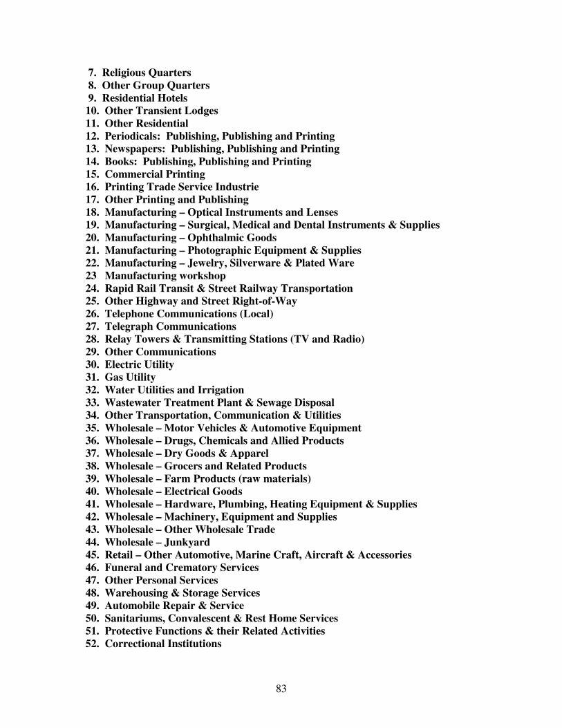
83
7. Religious Quarters 8. Other Group Quarters 9. Residential Hotels 10. Other Transient Lodges 11. Other Residential 12. Periodicals: Publishing, Publishing and Printing 13. Newspapers: Publishing, Publishing and Printing 14. Books: Publishing, Publishing and Printing 15. Commercial Printing 16. Printing Trade Service Industrie 17. Other Printing and Publishing 18. Manufacturing – Optical Instruments and Lenses 19. Manufacturing – Surgical, Medical and Dental Instruments & Supplies 20. Manufacturing – Ophthalmic Goods 21. Manufacturing – Photographic Equipment & Supplies 22. Manufacturing – Jewelry, Silverware & Plated Ware 23 Manufacturing workshop 24. Rapid Rail Transit & Street Railway Transportation 25. Other Highway and Street Right-of-Way 26. Telephone Communications (Local) 27. Telegraph Communications 28. Relay Towers & Transmitting Stations (TV and Radio) 29. Other Communications 30. Electric Utility 31. Gas Utility 32. Water Utilities and Irrigation 33. Wastewater Treatment Plant & Sewage Disposal 34. Other Transportation, Communication & Utilities 35. Wholesale – Motor Vehicles & Automotive Equipment 36. Wholesale – Drugs, Chemicals and Allied Products 37. Wholesale – Dry Goods & Apparel 38. Wholesale – Grocers and Related Products 39. Wholesale – Farm Products (raw materials) 40. Wholesale – Electrical Goods 41. Wholesale – Hardware, Plumbing, Heating Equipment & Supplies 42. Wholesale – Machinery, Equipment and Supplies 43. Wholesale – Other Wholesale Trade 44. Wholesale – Junkyard 45. Retail – Other Automotive, Marine Craft, Aircraft & Accessories 46. Funeral and Crematory Services 47. Other Personal Services 48. Warehousing & Storage Services 49. Automobile Repair & Service 50. Sanitariums, Convalescent & Rest Home Services 51. Protective Functions & their Related Activities 52. Correctional Institutions
84
53. University, College, Junior College & Professional School Education 54. Special Training & Schooling 55. Nature Exhibits 56. Other Cultural Activities & Nature Exhibitions 57. Other Public Assembly 58. Sports Activities 59. Playgrounds & Athletic Areas 60. Parks – General Recreation 61. Parks – Leisure & Ornamental 62. Other Parks 63. Other Cultural, Entertainment & Recreational 64. Wind Energy Conversion Systems
7.6 COMMERCIAL DISTRICT (C)
7.6.1 This district has been created to provide an area for necessarily commercial
uses generally found serving local areas in towns, highway traffic, etc. and
to contain these necessary activities so that they will not become a nuisance
to other types of uses.
7.6.2 Floor area ratio – not to exceed .7.
7.6.3 Lot area shall not be less than 8,000 square feet.
7.6.4 Setbacks shall come within 10 feet either way of the average setback of any
buildings within 400 feet on each side of the lot, but shall in no case be less
than 30 feet. If no other buildings exist within 400 feet, setback shall not be
less than 30 feet.
7.6.5 Any building intended for residential use on floors above the ground floor
shall have side yards not less than 30 feet wide, and rear yard not less than
40 feet wide.
a. For a building more than three stories in height, there shall be one
square foot of open space for each two square feet of gross floor area
of such building, except floor areas of basement or attics not used for
residence purposes. Required yards may be included as part of such

85
open space and one-half of parking lot area may also be included.
7.6.6 Parking Requirements
a. For residential use, at least 2 off-street parking stalls per D.U.
b. For hotels, at least one parking stall for each 3 guest sleeping rooms.
c. For eating and drinking places, at least one parking stall for each 5
seats, except when they are in a building which provides parking
space, in which case no additional parking stalls are required.
d. For retail and wholesale stores, at least one parking stall for each 120
square feet of store floor area devoted to sales.
e. For office uses, at least one parking stall for each 300 square feet of
office floor area.
f. All parking stalls provided pursuant to this section shall be on the
same lot with the building, except that the Board of Zoning Appeals
may permit the parking spaces to be on any lot within 250 feet of the
building, if it determines that it is impractical to provide parking on
the same lot with the building.
7.6.7 Signs intended to be seen outside the lot lines.
a. No sign shall project beyond a lot line, obstruct in any way a driver’s
vision of the road or hinder his passage in any way.
b. No sign shall be so placed as to hinder or obstruct any pedestrian
movement along any pedestrian path.
7.6.8 Off-Street Loading: On the same premises with every building or structure
erected hereafter and occupied for use involving the receipt or distribution
by vehicle of material or merchandise, there shall be provided and
maintained on the lot adequate space for standing, loading and unloading in
order to avoid undue interference with public use of the street or alley. Such
space, unless otherwise adequately provided for, shall include a ten (10) foot
height by twenty five (25) foot loading space with a fourteen (14) foot height
distance for every twenty thousand (20,000) square feet or fraction thereof
in excess of three thousand (3,000) square feet of floor area or land areas
86
used for the aforementioned purposes. These requirements may upon
appeal be increased, modified or waived by the Board of Zoning Appeals
where the conditions or circumstances justify such action provided
recommendations have been provided from the Law Enforcement Office
under whose jurisdiction the site falls.
7.6.9 Whenever a commercial use comes within five hundred (500) feet of an R1,
R-2, PUD, MH district, appropriate screening such as vegetation, wall, or
uniformly painted fence, at least seven (7) feet high, shall be used to screen
loading docks and parking lots visually from the surrounding D.U.’s.
7.6.10 No commercial building shall come within thirty five (35) feet of an R1, R2,
PUD, or MH district boundary line.
7.6.11 Whenever 60% or more of the property owners adjacent to a property
Believe that they are being adversely affected by an activity of the property
owner in question, they may present a petition, signed by them, to the
Executive Director who shall research the issue and prescribe appropriate
action to be taken.
7.6.12 Restrictions for Special Exceptions (in addition to those specified in Section
9)
a. Restrictions for Code 210 Manufacturing Workshop
1. Manufacturing to be performed by a maximum of 10 full-
time employees.
2. Manufacturing to be performed within an enclosed
building.
3. Raw materials and manufactured inventory to be stored
within an enclosed building; or within an area enclosed on all
sides with a solid wall, compact evergreen screen or
uniformly painted fence not less than 7 feet in height.
4. All Restrictions of 6.3.5 apply.

87
b. Restrictions for Manufacturing uses (as classified in Appendix E
between code 211 and 400, and listed in the schedule of uses as
special exceptions).
1. Employees shall not number greater than 15.
2. No unsafe, uncomfortable or offensive vibrations, noises,
visual effects or air pollutants shall be allowed to radiate
across lot lines.
c. Restrictions for 470
Refer to Section 6.2.9 Wireless Telecommunication Facilities
d. Restrictions for 480
Refer to Section 6.2.10 Wind Energy Conversion System
e. Restrictions for 481-484: Utilities Substations
1. See Section 6.3.1.14: Residential District Special
Exceptions,
Restrictions for 481-484: Utilities Substations
f. Restrictions for 485: Solid Waste Disposal and 486: Major
Utilities, Stations and Plants.
1. No structure shall be placed within sixty (60) feet of any
lot line.
2. All structures erected, placed or moved specifically for the
operation of the utility or for Solid Waste Disposal shall
be completely surrounded or enclosed by a building or
fence. A fence shall be at least nine (9) feet high.
3. No unsafe, uncomfortable, or offensive vibrations, noises,
visual effects, odors, or air pollutants shall be allowed to
radiate across lot lines.
4. All solid waste disposal sites shall conform to the
restrictions on their location and operation established by
the State Board of Health.
g. Restrictions for 637: Warehousing and Storage Services
1. All activities shall be carried out within a totally enclosed
building except off-street loading facilities, which shall be
visually screened from public thoroughfares and
pedestrians sidewalks.
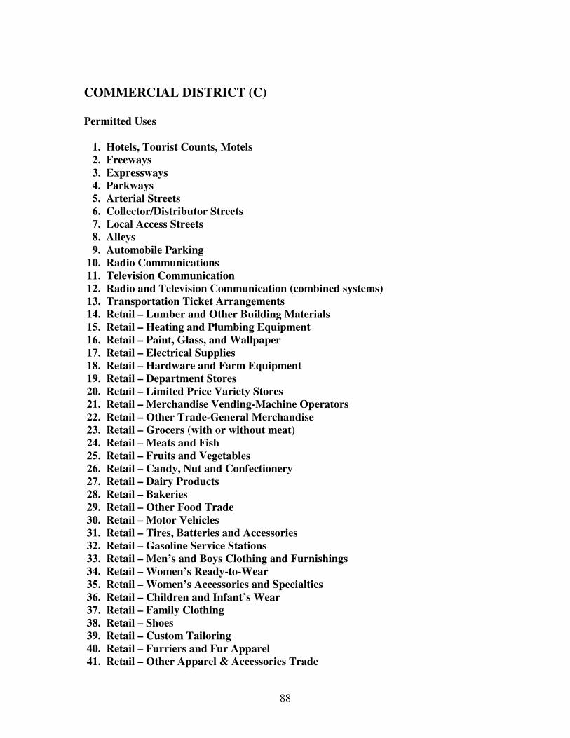
88
COMMERCIAL DISTRICT (C) Permitted Uses 1. Hotels, Tourist Counts, Motels 2. Freeways 3. Expressways 4. Parkways 5. Arterial Streets 6. Collector/Distributor Streets 7. Local Access Streets 8. Alleys 9. Automobile Parking 10. Radio Communications 11. Television Communication 12. Radio and Television Communication (combined systems) 13. Transportation Ticket Arrangements 14. Retail – Lumber and Other Building Materials 15. Retail – Heating and Plumbing Equipment 16. Retail – Paint, Glass, and Wallpaper 17. Retail – Electrical Supplies 18. Retail – Hardware and Farm Equipment 19. Retail – Department Stores 20. Retail – Limited Price Variety Stores 21. Retail – Merchandise Vending-Machine Operators 22. Retail – Other Trade-General Merchandise 23. Retail – Grocers (with or without meat) 24. Retail – Meats and Fish 25. Retail – Fruits and Vegetables 26. Retail – Candy, Nut and Confectionery 27. Retail – Dairy Products 28. Retail – Bakeries 29. Retail – Other Food Trade 30. Retail – Motor Vehicles 31. Retail – Tires, Batteries and Accessories 32. Retail – Gasoline Service Stations 33. Retail – Men’s and Boys Clothing and Furnishings 34. Retail – Women’s Ready-to-Wear 35. Retail – Women’s Accessories and Specialties 36. Retail – Children and Infant’s Wear 37. Retail – Family Clothing 38. Retail – Shoes 39. Retail – Custom Tailoring 40. Retail – Furriers and Fur Apparel 41. Retail – Other Apparel & Accessories Trade

89
42. Retail – Furniture, Home Furnishings and Equipment 43. Retail – Household Appliances 44. Retail – Radios, Televisions and Music Supplies 45. Retail – Eating Places 46. Retail – Drinking Places (alcoholic beverages) 47. Retail – Drug and Proprietary 48. Retail – Liquor 49. Retail – Antiques and Secondhand Merchandise 50. Retail – Book and Stationery 51. Retail – Sporting Goods and Bicycles 52. Retail – Farm and Garden Supplies 53. Retail – Jewelry 54. Retail – Fuel and Ice 55. Retail – Other Trade 56. Greenhouses 57. Banking and Bank-related Functions 58. Credit Services (other than banks) 59. Security & Commodity Brokers, Dealers, Exchanges & Services 60. Insurance Carriers, Agents, Brokers & Services 61. Real Estate and Related Services 62. Holding and Investment Services 63. Other Finance, Insurance & Real Estate Services 64. Laundering, Dry Cleaning and Dyeing Services 65. Photographic Services (including commercial) 66. Beauty & Barber Services 67. Apparel repair, Alteration & Cleaning Pick-up Service, Shoe Repair Service 68. Consumer and Mercantile Credit Reporting Services: Adjustment and Collection Services 69. Duplicating Mailing & Stenographic Services 70. Dwelling & other Building Services 71. Employment Services 72. Other Business Services 73. Automobile Repair & Service 74. Other Repair Services 75. Medical & Other Health Services 76. Legal Services 77. Other Professional Services 78. Protective Functions & their Related Activities 79. Postal Services 80. Welfare & Charitable Services 81. Entertainment Assembly 82. Playgrounds & Athletic Areas 83. Parks – Leisure & Ornamental 84. Animal Husbandry Services
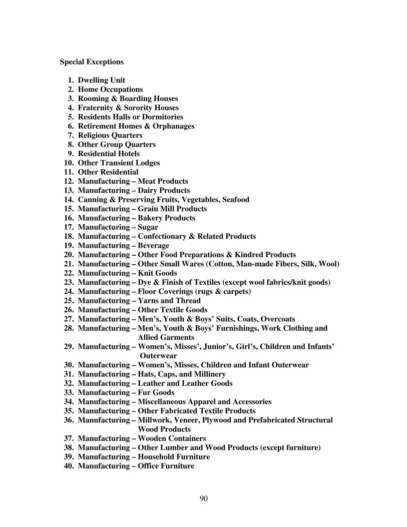
90
Special Exceptions 1. Dwelling Unit 2. Home Occupations 3. Rooming & Boarding Houses 4. Fraternity & Sorority Houses 5. Residents Halls or Dormitories 6. Retirement Homes & Orphanages 7. Religious Quarters 8. Other Group Quarters 9. Residential Hotels 10. Other Transient Lodges 11. Other Residential 12. Manufacturing – Meat Products 13. Manufacturing – Dairy Products 14. Canning & Preserving Fruits, Vegetables, Seafood 15. Manufacturing – Grain Mill Products 16. Manufacturing – Bakery Products 17. Manufacturing – Sugar 18. Manufacturing – Confectionary & Related Products 19. Manufacturing – Beverage 20. Manufacturing – Other Food Preparations & Kindred Products 21. Manufacturing – Other Small Wares (Cotton, Man-made Fibers, Silk, Wool) 22. Manufacturing – Knit Goods 23. Manufacturing – Dye & Finish of Textiles (except wool fabrics/knit goods) 24. Manufacturing – Floor Coverings (rugs & carpets) 25. Manufacturing – Yarns and Thread 26. Manufacturing – Other Textile Goods 27. Manufacturing – Men’s, Youth & Boys’ Suits, Coats, Overcoats 28. Manufacturing – Men’s, Youth & Boys’ Furnishings, Work Clothing and Allied Garments
29. Manufacturing – Women’s, Misses’, Junior’s, Girl’s, Children and Infants’ Outerwear
30. Manufacturing – Women’s, Misses, Children and Infant Outerwear 31. Manufacturing – Hats, Caps, and Millinery 32. Manufacturing – Leather and Leather Goods 33. Manufacturing – Fur Goods 34. Manufacturing – Miscellaneous Apparel and Accessories 35. Manufacturing – Other Fabricated Textile Products 36. Manufacturing – Millwork, Veneer, Plywood and Prefabricated Structural Wood Products 37. Manufacturing – Wooden Containers 38. Manufacturing – Other Lumber and Wood Products (except furniture) 39. Manufacturing – Household Furniture 40. Manufacturing – Office Furniture

91
41. Manufacturing – Public Building and Related Furniture 42. Manufacturing – Partitions, Shelving, Lockers, Office & Store Fixtures 43. Manufacturing – Other Furniture and Fixtures 44. Periodicals: Publishing, Publishing and Printing 45. Newspapers: Publishing, Publishing and Printing 46. Books: Publishing, Publishing and Printing 47. Commercial Printing 48. Manifold Business Forms 49. Manufacturing – Greeting Cards 50. Manufacturing – Bookbinding & Related Industries 51. Printing Trade Service Industries 52. Other Printing and Publishing 53. Manufacturing – Engineering, Laboratory, Scientific and Research Instruments and Associated Equipment 54. Manufacturing – Instruments for Measuring, Controlling and Indicating Physical Characteristics 55. Manufacturing – Optical Instruments and Lenses 56. Manufacturing – Surgical, Medical, and Dental Instruments & Supplies 57. Manufacturing – Ophthalmic Goods 58. Manufacturing – Photographic Equipment & Supplies 59. Manufacturing – Watches, Clocks, Clockwork Operated Devices & Parts 60. Manufacturing – Jewelry, Silverware & Plated Ware 61. Manufacturing – Musical Instruments and Parts 62. Manufacturing – Toys, Amusement, Sporting and Athletic Goods 63. Manufacturing – Pen, Pencils and Other Office and Artists Materials 64. Manufacturing – Novelties, Buttons, and Misc. Notions (except precious metals) 65. Manufacturing workshop 66. Motion Picture Production 67. Other Miscellaneous Manufacturing 68. Rapid Rail Transit & Street Railway Transportation 69. Railroad Passenger Terminals 70. Bus Transportation 71. Other Highway and Street Right-of-Way 72. Telephone Communications (Local) 73. Telegraph Communications 74. Relay Towers & Transmitting Stations (TV and Radio) 75. Other Communications 76. Electric Utility 77. Gas Utility 78. Water Utilities and Irrigation 79. Wastewater Treatment Plant & Sewage Disposal 80. Solid Waste Disposal 81. Major Utilities 82. Other Utilities 83. Other Pipeline Right-of-Way
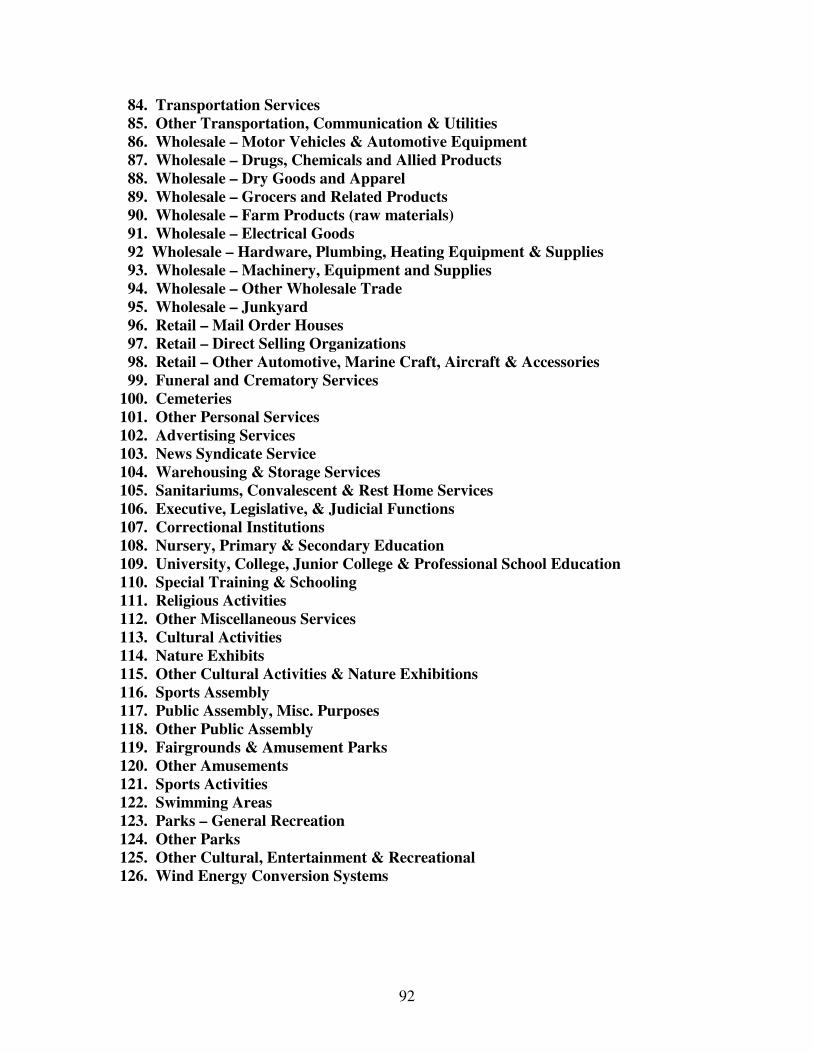
92
84. Transportation Services 85. Other Transportation, Communication & Utilities 86. Wholesale – Motor Vehicles & Automotive Equipment 87. Wholesale – Drugs, Chemicals and Allied Products 88. Wholesale – Dry Goods and Apparel 89. Wholesale – Grocers and Related Products 90. Wholesale – Farm Products (raw materials) 91. Wholesale – Electrical Goods 92 Wholesale – Hardware, Plumbing, Heating Equipment & Supplies 93. Wholesale – Machinery, Equipment and Supplies 94. Wholesale – Other Wholesale Trade 95. Wholesale – Junkyard 96. Retail – Mail Order Houses 97. Retail – Direct Selling Organizations 98. Retail – Other Automotive, Marine Craft, Aircraft & Accessories 99. Funeral and Crematory Services 100. Cemeteries 101. Other Personal Services 102. Advertising Services 103. News Syndicate Service 104. Warehousing & Storage Services 105. Sanitariums, Convalescent & Rest Home Services 106. Executive, Legislative, & Judicial Functions 107. Correctional Institutions 108. Nursery, Primary & Secondary Education 109. University, College, Junior College & Professional School Education 110. Special Training & Schooling 111. Religious Activities 112. Other Miscellaneous Services 113. Cultural Activities 114. Nature Exhibits 115. Other Cultural Activities & Nature Exhibitions 116. Sports Assembly 117. Public Assembly, Misc. Purposes 118. Other Public Assembly 119. Fairgrounds & Amusement Parks 120. Other Amusements 121. Sports Activities 122. Swimming Areas 123. Parks – General Recreation 124. Other Parks 125. Other Cultural, Entertainment & Recreational 126. Wind Energy Conversion Systems

93
7.7 RURAL RESIDENTIAL DISTRICT (A1) (Added effective 07-02-
2007)
7.7.1 Rural Residential (A-1): This district has been created to provide single
family housing for those who are not engaged in farming activities but nonetheless
seek housing outside the incorporated city limits in a transitional area between
traditional agricultural uses and urban areas. The use of municipal services and
utilities shall be encouraged in this district.
7.7.2 Uses.
See Appendix E for Permitted Uses and Special Exceptions.
7.7.3 Developmental Standards.
a. The maximum lot size for new construction is two (2) acres. The
maximum lot size for subdivision of a lot on which an existing home is
located is four (4) acres if such additional acreage is needed to comply with
setback requirements, inclusion of accessory buildings, and/or creation of a
remainder that is consistent with agricultural uses thereon. Variance from
lot size requirements may be granted by Board of Zoning Appeals. Homes
that utilize municipal sewer services may have a minimum lot size of one-
half (1/2) acre.
b. Minimum Lot Width is two hundred feet (200’) which shall be measured
by using the front property line.
c. Yard Setbacks for CFO/CAFO
1. Minimum Front Yard Setback is seven hundred fifty feet (750’)
from State highways which shall be measured for the edge of the
public right-of-way. Minimum Front Yard Setback is one thousand
five hundred feet (1500’) for Federal highways which shall be
measured from the edge of the public right-of-way. These setback
requirements may be reduced to six hundred sixty feet (660’) and
one thousand feet (1000’), respectively, if an industry approved
buffer, which is designed according to Natural Resources
Conservation Service (“NRCS”) guideline, is implemented.

94
2. Minimum Side Yard Setback is two hundred feet (200’) which
shall be measured from the property line.
3. Minimum Rear Yard Setback is two hundred feet (200’) which
shall be measured from the property line.
d. Yard Setbacks for Housing
1. Minimum Front Yard Setback is fifty feet (50’) which shall be
measured from the edge of the public right-of-way.
2. Minimum Side Yard Setback is twenty feet (20’) which shall be
measured from the property line.
3. Minimum Rear Yard Setback is twenty feet (20’) which shall be
measured from the property line.
e. Separation Distance from an existing Confined Feeding Operation
(“CFO”) or Concentrated Animal Feeding Operation (“CAFO”) structure
or an existing house shall be a minimum of seven hundred-fifty feet (750’)
which shall be measured from the nearest CFO/CAFO structure (including
lagoons) to the nearest house. This standard shall apply reciprocally to
residential and agricultural development. Separation distance from an
existing CFO/CAFO structure or school shall be a minimum of one (1) mile
which shall be measured from the nearest CFO/CAFO structure to the
school. This Standard shall apply reciprocally to school and agricultural
development.
f. Additional Standards
1. A cul-de-sac or T-shaped turnaround shall be provided on
a single lot subdivision so that vehicles need not back onto
the street or roadway.
2. Private water wells shall be located at least fifty feet (50’)
from all property lines.
3. All applicants shall sign the “Notice of Agricultural Activity” located in Appendix D and the “Deed of Dedication Agricultural Zone Covenants” as set forth in the Rush County Subdivision Control Ordinance.
4. Access: If a proposed single lot subdivision does not abut a public road, it may be provided access with a 50 foot
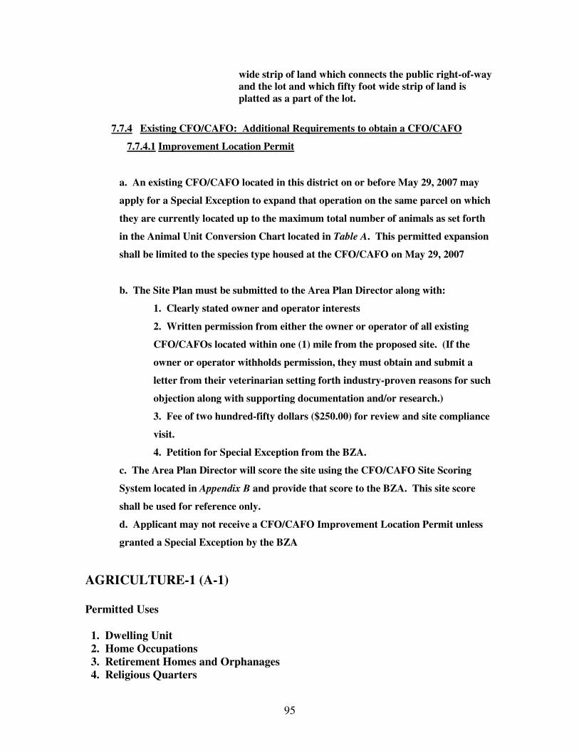
95
wide strip of land which connects the public right-of-way and the lot and which fifty foot wide strip of land is platted as a part of the lot.
7.7.4 Existing CFO/CAFO: Additional Requirements to obtain a CFO/CAFO
7.7.4.1 Improvement Location Permit
a. An existing CFO/CAFO located in this district on or before May 29, 2007 may
apply for a Special Exception to expand that operation on the same parcel on which
they are currently located up to the maximum total number of animals as set forth
in the Animal Unit Conversion Chart located in Table A. This permitted expansion
shall be limited to the species type housed at the CFO/CAFO on May 29, 2007
b. The Site Plan must be submitted to the Area Plan Director along with:
1. Clearly stated owner and operator interests
2. Written permission from either the owner or operator of all existing
CFO/CAFOs located within one (1) mile from the proposed site. (If the
owner or operator withholds permission, they must obtain and submit a
letter from their veterinarian setting forth industry-proven reasons for such
objection along with supporting documentation and/or research.)
3. Fee of two hundred-fifty dollars ($250.00) for review and site compliance
visit.
4. Petition for Special Exception from the BZA.
c. The Area Plan Director will score the site using the CFO/CAFO Site Scoring
System located in Appendix B and provide that score to the BZA. This site score
shall be used for reference only.
d. Applicant may not receive a CFO/CAFO Improvement Location Permit unless
granted a Special Exception by the BZA
AGRICULTURE-1 (A-1) Permitted Uses 1. Dwelling Unit 2. Home Occupations 3. Retirement Homes and Orphanages 4. Religious Quarters

96
5. Other Groups Quarters 6. Other Highway and Street Right-of-Way 7. Automobile Parking 8. Telephone Communications (Local) 9. Telegraph Communications 10. Dwelling & Other Building Services 11. Other Amusements 12. Farms (predominately crop – Fibers) 13. Farms (predominately crop - Cash Grain) 14. Farms (Field Crops other than fiber or cash grain crops) 15. Farms (predominately crop – Fruits, Tree Nuts, or Vegetables) 16. Farms (General – no predominance) 17. Other Agriculture & Related Activities 18. Agriculture Use, Less than 10 Acres (other than confinement feeding) 19. Other Agriculture Related Activities 20. Commercial Forestry Production 21. Forestry Service 22. Other Forestry Activities 23. Forest Reserves Special Exceptions 1. Rooming & Boarding Houses 2. Fraternity & Sorority Houses 3. Resident Halls or Dormitories 4. Residential Hotels 5. Hotels, Tourist Courts, Motels 6. Other Residential 7. Relay Towers & Transmitting Stations (TV and radio) 8. Electric Utility 9. Gas Utility 10. Water Utilities and Irrigation 11. Water Treatment Plant & Sewage Disposal 12. Solid Waste Disposal 13. Major Utilities, Stations and Plants 14. Other Utilities 15. Other Pipeline Right-of-Way and Pressure Control Stations 16. Transportation Service 17. Other Transportation, Communication & Utilities 18. Beauty & Barber Services 19. Cemeteries 20. Other Personal Services 21. Nursery, Primary, & Secondary Education 22. University, College, Junior College & Professional School Education 23. Special Training & Schooling
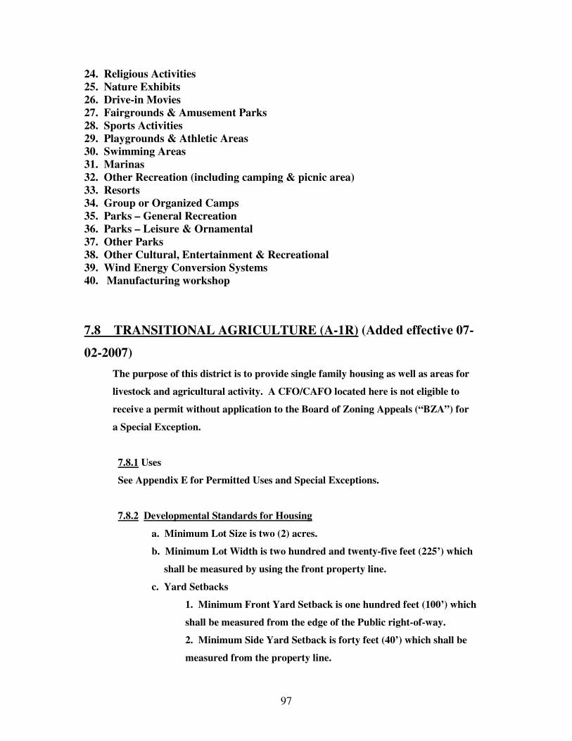
97
24. Religious Activities 25. Nature Exhibits 26. Drive-in Movies 27. Fairgrounds & Amusement Parks 28. Sports Activities 29. Playgrounds & Athletic Areas 30. Swimming Areas 31. Marinas 32. Other Recreation (including camping & picnic area) 33. Resorts 34. Group or Organized Camps 35. Parks – General Recreation 36. Parks – Leisure & Ornamental 37. Other Parks 38. Other Cultural, Entertainment & Recreational 39. Wind Energy Conversion Systems 40. Manufacturing workshop
7.8 TRANSITIONAL AGRICULTURE (A-1R) (Added effective 07-
02-2007)
The purpose of this district is to provide single family housing as well as areas for
livestock and agricultural activity. A CFO/CAFO located here is not eligible to
receive a permit without application to the Board of Zoning Appeals (“BZA”) for
a Special Exception.
7.8.1 Uses
See Appendix E for Permitted Uses and Special Exceptions.
7.8.2 Developmental Standards for Housing
a. Minimum Lot Size is two (2) acres.
b. Minimum Lot Width is two hundred and twenty-five feet (225’) which
shall be measured by using the front property line.
c. Yard Setbacks
1. Minimum Front Yard Setback is one hundred feet (100’) which
shall be measured from the edge of the Public right-of-way.
2. Minimum Side Yard Setback is forty feet (40’) which shall be
measured from the property line.
98
3. Minimum Rear Yard Setback is forty feet (40’) which shall be
measured from the property line.
d. Separated Distance from an existing CFO/CAFO structure or house shall
be a minimum of one thousand feet (1000’) which shall be measured from
the nearest CFO/CFO structure including lagoons to the nearest house. This
standard shall apply reciprocally to residential and agricultural
development. Separation distance from an existing CFO/CAFO structure or
school shall be a minimum of one (1) mile which shall be measured from the
nearest CFO/CAFO structure to the school. This standard shall apply
reciprocally to school and agricultural development.
e. Additional Standards
1. A cul-de-sac or T-shaped turnaround shall be provided on a
single lot subdivision so that vehicles need not back onto the
street or roadway.
2. Private water wells shall be located at least fifty feet (50’) from
a property line.
3. All applicants shall sign the “Notice of Agricultural Activity” Located in Appendix D and the Deed of Dedication Agricultural Zone Covenants as set forth in the Rush County Subdivision Control Ordinance.
4. Access: If a proposed single lot subdivision does not abut a public
road, it may be provided access with a 50 foot wide strip of land which connects the public right-of-way and the lot and which fifty foot wide strip of land is platted as a part of the lot.
7.8.3 Developmental Standards for CFO/CAFO
a. Minimum Lot Size is forty (40) acres.
b. Minimum Lot Width is two hundred fifty feet (250’) which shall be
measured by using the front property line.
c. Yard Setbacks
1. Minimum Front Yard Setback is seven hundred fifty feet (750’)
for state highways which shall be measured from the edge of the
public right-of-way. Minimum Front Yard Setback is one thousand
five hundred (1500’) for federal highways which shall be measured
from the edge of the public right-of-way. These setback
requirements may be reduced to six hundred sixty feet (660’) and
99
one thousand feet (1000’), respectively, if an industry approved
buffer, which is designed
according to Natural Resources Conservation Service (“NRCS”)
guideline, is implemented.
2. Minimum Side Yard Setback is two hundred feet (200’) which
shall be measured from the property line.
d. Separation Distance from an existing CFO/CAFO structure or house
shall be a minimum of seven hundred fifty feet (750’) which shall be
measured from the nearest CFO/CAFO structure (including lagoons) to the
nearest house. This standard shall apply reciprocally to residential and
agricultural development. Separation distance from an existing CFO/CAFO
structure or school shall be a minimum of one (1) mile which shall be
measured from the nearest CFO/CAFO structure to the school. This
standard shall apply reciprocally to school and agricultural development.
e. Additional Standards
1. A cul-de-sac or T-shaped turnaround shall be provided on a
single lot subdivision so that vehicles need not back onto the street or
roadway.
2. Private water wells shall be located at least fifty feet (50’) from all
property lines.
3. All applicants shall sign the “Notice of Agricultural Activity”
located in Appendix D and the Deed of Dedication Agricultural Zone
Covenants as set forth in the Rush County Subdivision Control
Ordinance.
7.8.4 Additional Requirements to obtain a CFO/CFO Improvement
Location Permit
a. The proposed CFO/CAFO must be located at least one (1) mile from all
public schools.
b. The Site Plan must be submitted to the Area Plan Director along with:
1. Clearly stated owner and operator interests.
2. Written permission from either the owner or operator of all
existing CFO/CAFOs located within one (1) mile from the proposed

100
site. (If the owner or operator withholds permission, they must
obtain and submit a letter from their veterinarian setting forth
industry-proven reasons for such objection along with supporting
documentation and/or research.)
3. Fee of two hundred-fifty dollars ($250.00) for review and site
compliance visit.
4. Petition for Special Exception from the BZA.
c. The Area Plan Director will score the site using the CFO/CAFO Site
Scoring System located in Appendix B and provide that score to the BZA.
d. Applicant may not receive a CFO/CAFO Improvement Location Permit
unless granted a Special Exception by the BZA.
7.8.5 Existing CFO/CAFO Special Exception
a. An existing CFO/CAFO located in this district on or before May 29, 2007
may apply for a Special Exception to expand that operation on the same
parcel on which they are currently located up to the maximum total number
of animals as set forth in the Animal Unit Conversion Chart located in Table
A.
b. Applicant may not receive a CFO/CAFO Improvement Location Permit
unless granted a Special Exception by the BZA.
AGRICULTURE -1R
Permitted Uses 1. Dwelling Unit 2. Home Occupations 3. Retirement Homes & Orphanages 4. Religious Quarters 5. Other Group Quarters 6. Other Highway and Street Right-of-Way 7. Automobile Parking 8. Telephone Communications (Local) 9. Telegraph Communications 10. Dwelling & Other Building Services 11. Other Amusements 12. Farms (predominately crop – Fibers) 13. Farms (predominately crop – Cash Grain) 14. Farms (Field Crops other than fiber or cash grain crops)

101
15. Farms (predominately crop – Fruits, Tree Nuts, or Vegetables) 16. Farms (General – no predominance) 17. Other Agriculture & Related Activities 18. Agriculture Use, Less Than 10 Acres (other than confinement feeding) 19. Other Agricultural Related Activities 20. Commercial Forestry Production 21. Forestry Service 22. Other Forestry Activities 23. Forest Reserves Special Exceptions 1. Rooming & Boarding Houses 2. Fraternity & Sorority Houses 3. Residents Halls or Dormitories 4. Residential Hotels 5. Hotels, Tourist Courts, Motels 6. Other Residential 7. Relay Towers & Transmitting Stations (TV and radio) 8. Electric Utility 9. Gas Utility 10. Water Utilities and Irrigation 11. Wastewater Treatment Plant & Sewage Disposal 12. Solid Waste Disposal 13. Major Utilities, Stations and Plants 14. Other Utilities 15. Other Pipeline Right-of-Way and Pressure Control Stations 16. Transportation Services 17. Other Transportation, Communication & Utilities 18. Beauty & Barber Services 19. Cemeteries 20. Other Personal Services 21. Nursery, Primary & Secondary Education 22. University, College, Junior College & Professional School Education 23. Special Training & Schooling 24. Religious Activities 25. Nature Exhibits 26. Drive-in Movies 27. Fairgrounds & Amusement Parks 28. Sports Activities 29. Playgrounds & Athletic Areas 30. Swimming Areas 31. Marinas 32. Other Recreation (including camping & picnic areas) 33. Resorts 34. Group or Organized Camps

102
35. Parks – General Recreation 36. Parks – Leisure & Ornamental 37. Other Parks 38. Other Cultural, Entertainment & Recreational 39. Wind Energy Conversion Systems 40. Manufacturing workshop
7.9 AGRI-BUSINESS (A-2) (Added effective 07-02-2007)
The purpose of this district is to allow agricultural-based businesses to locate in close
proximity to related agricultural activity.
7.9.1 Uses.
See Appendix E for Permitted Uses and Special Exceptions.
7.9.2 Developmental Standards
a. Minimum Lot Size is ten (10) acres.
b. Minimum Lot Width is two hundred and fifty feet (250’) which shall be
measured by using the front property line.
c. Yard Setbacks
1. Minimum Front yard Setback is sixty feet (60’) which shall be
measured from the edge of the public right-of-way.
2. Minimum Side Yard Setback is thirty feet (30’) which shall be
measured from the property line.
3. Minimum Rear Yard Setback is thirty feet (30’) which shall be
measured from the property line.
AGRICULTURE – 2 (A-2) Permitted Uses 1. Manufacturing – Agricultural Chemicals 2. Other Motor Vehicle Transportation 3. Airports and Flying Fields 4. Other Aircraft Transportation 5. Marine Terminals 6. Other Marine Craft Transportation 7. Other Highway and Street Right-of-Way 8. Automobile Parking 9. Telephone Communications (Local)
103
10. Telegraph Communications 11. Retail – Lumber and Other Building Materials 12. Retail – Heating and Plumbing Equipment 13. Retail – Paint, Glass and Wallpaper 14. Retail – Electrical Supplies 15 Retail – Hardware and Farm Equipment 16. Retail – Department Stores 17. Retail – Mail Order Houses 18. Retail – Limited Price Variety Stores 19. Retail – Merchandise Vending-Machine operators 20. Retail – Direct Selling Organizations 21. Retail – Other Trade-General Merchandise 22. Retail – Grocers (with or without meat) 23. Retail – Meat & Fish 24. Retail – Fruits & Vegetables 25. Retail – Candy, Nut and Confectionery 26. Retail – Dairy Products 27. Retail – Bakeries 28. Retail – Other Food Trade 29. Retail – Motor Vehicles 30. Retail – Tires, Batteries and Accessories 31. Retail – Gasoline Service Stations 32. Retail – Other Automotive, Marine Craft, Aircraft & Accessories 33. Retail – Men’s and Boys Clothing and Furnishings 34. Retail – Women’s Ready-to-Wear 35. Retail – Women’s Accessories and Specialties 36. Retail – Children and Infants Wear 37. Retail – Family Clothing 38. Retail – Shoes 39. Retail – Custom Tailoring 40. Retail – Furriers and Fur Apparel 41. Retail – Other Apparel & Accessories Trade 42. Retail – Furniture, Home Furnishings and Equipment 43. Retail – Household Appliances 44. Retail – Radios, Televisions and Music Supplies 45. Retail – Eating Places 46. Retail – Drinking Places (alcoholic beverages) 47. Retail – Drug and Propriety 48. Retail – Liquor 49. Retail – Antiques and Secondhand Merchandise 50. Retail – Book and Stationery 51. Retail – Sporting Goods and Bicycles 52. Retail – Farm and Garden Supplies 53. Retail – Retail Jewelry 54. Retail – Fuel and Ice 55. Retail – Other

104
56. Greenhouses 57. Banking and Bank-related Functions 58. Credit Services (other than banks) 59. Security & Commodity Brokers, Dealers, Exchanges & Services 60. Insurance Carriers, Agents, Brokers & Service 61. Real Estate and Related Services 62. Holding & Investment Services 63. Other Finance, Insurance & Real Estate Services 64. Photographic Services (including commercial) 65. Beauty and Barber Services 66. Cemeteries 67. Dwelling & Other Building Services 68. Warehousing & Storage Services 69. Automobile Repair & Service 70. Other Repair Services 71. General Contract Construction Services 72. Special Construction Trade Services 72. Marinas 73. Farms (predominately crop – Fibers) 74. Farms (predominately crop – Cash Grain) 75. Farms (Field Crops other than fiber or cash grain crops) 76. Farms (predominately crop – Fruits, Tree Nuts, or Vegetables) 77. Farms (General – no predominance) 78. Other Agriculture & Related Activities 79. Agriculture Use, Less Than 10 Acres (other than confinement feeding) 80. Other Agriculture Related Activities 81. Commercial Forestry Production 82. Forestry Service 83. Other Forestry Activities 84. Fisheries & Marine Products 85. Other Fishery Activities & Related Services 86. Forest Reserves Special Exceptions 1. Relay Towers & Transmitting Stations (TV and radio) 2. Electric Utility 3. Gas Utility 4. Water Utilities and Irrigation 5. Wastewater Treatment Plant & Sewage Disposal 6. Solid Waste Disposal 7. Major Utilities, Stations and Plants 8. Other Utilities 9. Other Pipeline Right-of-Way and Pressure Control Stations 10. Transportation Services 11. Other Transportation, Communication & Utilities

105
12. Military Bases & Reservations 13. Fairgrounds & Amusement Parks 14. Swimming Areas 15. Wind Energy Conversion Systems 16. Manufacturing workshop
7.10 REGULATED LIVESTOCK (A-3) (Added effective 07-02-2007)
This district has been created to encourage the continuation of agricultural uses of land
while discouraging the addition of single family housing by property owners who are not
engaged in those agricultural activities. Larger livestock operations, including
CFO/CAFOs and other Indiana Department of Environmental Management (“IDEM”)
regulated activities may be permitted in this district as well crop production and other
traditional agricultural operations.
7.10.1 Uses.
See Appendix E for Permitted Uses and Special Exceptions.
7.10.2 Developmental Standards
a. Minimum Lot size is forty (40) acres.
b. Minimum Lot Width is two hundred fifty feet (250’) which shall
be measured by using the front property line.
c. Yard Setbacks for CFO/CAFO
1. Minimum Front Yard Setback is seven hundred fifty feet
(750’) for state highways which shall be measured from the
edge of the public right-of-way. Minimum Front Yard
Setback is one thousand five hundred feet (1500’) for federal
highways which shall be measured from the edge of the
public right-of-way. These setback requirements may be
reduced to six hundred sixty feet (660’) and one thousand
feet’ (1000’), respectively, if an industry approved buffer,
which is designed according to Natural Resources
Conservation Service (“NRCS”) guideline, is implemented.
2. Minimum Side Yard Setback is two hundred feet (200’)
which shall be measured from the property line.
106
3. Minimum Rear Yard Setback is two hundred feet (200’)
which shall be measured from the property line.
d. Yard Setbacks for Housing
1. Minimum Front Yard Setback is one hundred feet (100’)
which shall be measured from the edge of the public right-of-
way.
2. Minimum Side Yard Setback is forty feet (40’) which shall
be measured from the property line.
3. Minimum Rear Yard Setback is forty feet (40’) which
shall be measured from the property line.
e. Separation Distance from an existing CFO/CAFO structure or
house shall be a minimum of seven hundred fifty feet (750’) which
shall be measured from the nearest CFO/CAFO structure (including
lagoons) to the nearest house. This standard shall apply reciprocally
to residential and agricultural development. Separation distance
from an existing CFO/CAFO structure or school shall be a minimum
of one (1) mile which shall be measured from the nearest
CFO/CAFO structure to the school. This standard shall apply
reciprocally to school and agricultural development.
f. Additional Standards
1. A cul-de-sac or T-shaped turnaround shall be provided on
a single lot subdivision so that vehicles need not back onto
the street or roadway.
2. Private water wells shall be located at least fifty feet (50’)
from all property lines
3. All applicants shall sign the “Notice of Agricultural
Activity” located in located in Appendix D and the Deed of
Dedication Agricultural Zone Covenants as set forth in the
Rush County Subdivision Control Ordinance.
4. Access: If a proposed single lot subdivision does not abut
a public road, it may be provided access with a 50 foot wide
strip of land which connects the public right-of-way and the
lot and which fifty foot wide strip of land is platted as a part
of the lot.

107
7.10.3 Additional Requirements to Obtain an Improvement Location
Permit For CFO/CAFO (Without Application for a Special
Exception)
a. The proposed CFO/CAFO must be located at least one (1) mile
from all public schools.
b. The total number of animals to be housed on the parcel shall be
no more than the total animal units equivalent to eight thousand
(8000) head of swine (See Table A “Animal Unit Conversion Chart”
for all livestock equivalent units) with a deviation of no more than
the lesser of ten percent (10%) or six hundred (600) head which may
occur temporarily in order to compensate for mortality rates.
c. The applicant must score at least four hundred forty-five (445)
points on the CFO/CAFO Site Scoring System located in Appendix
B.
d. The Site Plan must be submitted to the Area Plan Director along
with:
1. Clearly stated owner and operator interests.
2. Written permission from either the owner or operator of
all existing CFOs/CAFOs located within one (1) mile from
the proposed site. (If the owner or operator withholds
permission, they must obtain and submit a letter from their
veterinarian setting forth industry-proven reasons for such
objection along with supporting documentation and/or
research.)
3. Fee of two hundred-fifty dollars ($250.00) for review and
site compliance visit.
e. Upon receipt of all required information, documentation and fees,
the Area Plan Director shall render a decision within five (5)
business days of submission.
1. If the application is approved, the Area Plan Director
shall provide appropriate permits.
108
2. If the application is denied, applicant may apply for a
Special Exception IF all requirements set forth in 6.3.6.4.4
below are met.
7.10.4 Additional Requirements to Obtain an Improvement Location
Permit For CFO/CAFO (With Application for a Special Exception)
a. Applicants who receive an unfavorable decision from the Area
Plan Director pursuant to 6.3.6.4.3 above, due to an inadequate score
on the CFO/CAFO Site Scoring System, may file an application for
Special Exception if:
1. Applicant scored at least three hundred forty-five (345)
points or,
2. Applicant scored less than three hundred forty five (345)
points, but such score was the result of a previous IDEM
violation.
7.10.5 Additional Requirements to obtain an Improvement Location
Permit for Housing on Less than (40) Forty Acres (Without Application for
a Special Exception)
a. Existing Home
1. The existing home is split from the parcel.
2. Deed for remainder of parcel (without existing home) shall
contain the following recital: “Hereafter, there shall be no
residential structure erected on the within described real
estate unless a Special Exception is first granted by the Rush
County Board of Zoning Appeals or the governing body in
place at such time.
3. Lot Size shall be a minimum of two (2) acres.
b. New Home
1. Applicant must score at least twenty-seven (27) points on
the Regulated Livestock (A-3) Housing Scoring System
located in
Appendix C.
109
7.10.6 Additional Requirements to Obtain an Improvement Location
Permit for Housing on Less than Forty (40) Acres (With Application for
Special Exception)
a. Applicants who receive an unfavorable decision from the Area
Plan Director pursuant to 6.3.6.11.5 above due to an inadequate
score on the Regulated Livestock (A-3) Housing Scoring System may
file an application for Special Exception if:
1. Applicant scored at least twenty-one (21) points.
7.10.7 Mobile Home and Travel Trailer
a. A mobile home or travel trailer may be permitted in this district
if:
1. Mobile home or travel trailer is located on an existing
farm where a permanent dwelling exists, and
2. The mobile home or travel trailer is used by a blood
relative or employee of the resident or the permanent
dwelling, and
3. The mobile home or travel trailer is placed on a
permanent foundation with tie downs and skirting and is
located within one hundred feet (100’) of the permanent
dwelling, and
4. A Special Exception is granted by the BZA.
i. The Special Exception must contain a requirement
that applicant remain in compliance with the
aforementioned requirements and provide an update
of such compliance to the BZA every two (2) years
from the date the Special Exception was originally
granted.
ii. Failure to comply with the aforementioned
compliance updates will result in the denial of an
extension or renewal of the Special Exception.
AGRICULTURE – 3 (A-3) Permitted Uses

110
1. Manufacturing – Meat Products 2. Manufacturing – Dairy Products 3. Other Highway and Street Right-of-Way 4. Automobile Parking 5. Telephone Communications (Local) 6. Telegraph Communications 7. Greenhouses 8. Farms (predominately crop – Fibers) 9. Farms (predominately crop – Cash Grain) 10. Farms (Field Crops other than fiber or cash grain crops 11. Farms (predominately crop – Fruit, Tree Nuts, or Vegetables) 12. Farms (predominately Dairy Products) 13. Farms and Ranches (Livestock other than Dairy) 14. Farms (predominately Poultry) 15. Farms (General – no predominance) 16. Other Agriculture & Related Activities 17. Animal Husbandry Services 18. Confinement Feeding 19. Other Agricultural Related Activities 20. Commercial Forestry Production 21. Forestry Service 22. Other Forestry Activities 23. Fisheries & Marine Products 24. Other Fishery Activities and Related Services 25. Forest Reserves 26. Ethanol Production 27. Bio-diesel Production 28. Wind Farms 29. Manure Digesters 30. Waste-to-Energy Converters 31. Any New Technology Using Agriculture By-Products Special Exceptions 1. Dwelling Unit 2. Home Occupations 3. Relay Towers & Transmitting Stations (TV and radio) 4. Electric Utility 5. Gas Utility 6. Water Utilities and Irrigation 7. Water Treatment Plant & Sewage Disposal 8. Solid Waste Disposal 9. Major Utilities, Stations and Plants 10. Other Utilities 11. Other Pipeline Right-of-Way and Pressure Control Stations
111
12. Transportation Services 13. Other Transportation, Communication & Utilities 14. Beauty & Barber Services 15. Military Bases & Reservations 16. Nursery, Primary & Secondary Education 17. Religious Activities 18. Fairgrounds & Amusement Parks 19. Group or Organized Camps 20. Agriculture Use, Less Than 10 Acres (other than confinement feeding) 21. Metal Ore Mining 22. Coal Mining 23. Crude Petroleum & Natural Gas 24. Mining & Quarrying of Non-metallic Minerals (except fuels) 25. Mining Services 26. Other Resource Production & Extraction 27. Sanitary Landfill 28. Wind Energy Conversion Systems 29. Manufacturing workshop
7.11 AGRICULTURAL PARK (A-4) (Added effective 07-02-2007) The
purpose of this district is to allow industrial-type uses that are related to or service
agricultural activity.
7.11.1 Uses
See Appendix E for Permitted Uses and Special Exceptions.
7.11.2 Developmental Standards
a. Minimum Lot Size is forty (40) acres.
b. Minimum Lot Width is six hundred feet (600’) which shall be
measured by using the front property line.
c. Yard Setbacks
1. Minimum Front yard Setback is two hundred feet (200’)
for state highways which shall be measured from the edge of
the public right-of-way. Minimum Front Yard Setback is six
hundred and sixty feet (660’) for federal highways which
shall be measured from the edge of the public right-of-way.
112
2. Minimum Side Yard Setback is two hundred feet (200’)
which shall be measured from the property line.
3. Minimum Rear Yard Setback is two hundred feet (200’)
which shall be measured from the property line
d. Additional Standards
AGRICULTURE – 4 (A-4)
Permitted Uses 1. Manufacturing – Meat Products 2. Manufacturing – Dairy Products 3. Other Highway and Street Right-of-Way 4. Automobile Parking 5. Telephone Communications (Local) 6. Telegraph Communications 7. Greenhouses 8. Laundering, Dry Cleaning, and Dyeing Services 9. Warehousing & Storage Services 10. Farms (predominately crop – Fibers) 11. Farms (predominately crop – Cash Grain) 12. Farms (Field Crops other than fiber or cash grain crops) 13. Farms (predominately crop – Fruit, Tree Nuts, or Vegetables) 14. Farms (General – no predominance) 15. Other Agriculture & Related Activities 16. Agriculture Processing 17. Other Agricultural Related Activities 18. Commercial Forestry Production 19. Forestry Service 20. Other Forestry Activities 21. Fisheries & Marine Products 22. Other Fishery Activities and Related Services 23. Forest Reserves 24. Ethanol Production 25. Bio-diesel Production 26. Wind Farms 27. Manure Digesters 28. Waste-to-Energy Converters 29. Any New Technology Using Agriculture By-Products Special Exceptions 1. Relay Towers & Transmitting Stations (TV and radio)
113
2. Electric Utility 3. Gas Utility 4. Water Utilities and Irrigation 5. Wastewater Treatment Plant and Sewage Disposal 6. Solid Waste Disposal 7. Major Utilities, Stations and Plants 8. Other Utilities 9. Other Pipeline Right-of-Way and Pressure Control Stations 10. Transportation Services 11. Other Transportation, Communication & Utilities 12. Wind Energy Conversion Systems 13. Manufacturing workshop
7.11.3 General Provisions for Agricultural Zones
7.11.3.1 Signs
Signs intended to be seen outside the lot lines:
a. Non-flashing illuminated business signs are permitted.
b. No more than one (1), twelve (12) square foot sign per principal
use is permitted.
c. No sign shall project beyond a lot line, obstruct in any way a
driver’s vision of the road or hinder his passage in any way.
d. No sign shall be so placed as to hinder or obstruct any pedestrian
movement along any pedestrian path.
7.11.3.2 Violations and Remedies
a. Livestock shall not be placed in a new facility until the Area Plan
Director determines there is adequate compliance with the approved
site plan which shall be attached to, and remain filed with, the
permit application and site score.
b. If at any time a CFO/CAFO or residence is found to be in non-
compliance with the approved site plan the following procedures
shall be followed by the Area Plan Director:
1. First Offense: Delivery of a written warning to the owner
or operator of the CFO/CAFO by the Area Plan Director
and a Rush County Sheriff Department deputy.
114
2. Second Offense: Imposition of a fine in the amount of two
thousand five hundred dollars ($2500.00).
3. Third Offense: Imposition of a fine in the amount of five
thousand dollars ($5000.00).
4. Fourth Offense: Imposition of a fine in the amount of five
thousand dollars ($5000.00) per day until compliance is
achieved.
c. Non-compliance must be rectified within five (5) days time from
written notice is given or fine is imposed. Failure to timely rectify
such non-compliance will be treated as a subsequent offense.
7.11.3.3 Agricultural buildings are exempt from permit requirements;
however, such agricultural buildings still are subject to zoning
requirements. A farm dwelling is exempt from special exception
requirements; however, such dwelling is still subject to zoning requirements
and requires an improvements location permit and septic permits. Does not
include hardship cases.
7.11.3.4 Performance Standards concerning noise, smoke, and particulate
matters, odors, vibration, glare, or heat do not apply to farm uses, grain and
livestock. However, toxic or noxious matter and fire and explosion hazard
performance standards do apply.
7.11.3.5 Restrictions for Special Exceptions (in addition to those in Appendix
E), also see Section 9 of the Rush County Zoning Ordinance for BZA
procedures.
a. Restrictions for Code 210 Manufacturing Workshop
1. Manufacturing to be performed by a maximum of 10 full-
time employees.
2. Manufacturing to be performed within an enclosed
building.
3. Raw materials and manufactured inventory to be stored
within an enclosed building; or within an area enclosed on all

115
sides with a solid wall, compact evergreen screen or
uniformly painted fence not less than 7 feet in height.
4. All Restrictions of 6.3.5 apply.
b. Restrictions for 470
Refer to Section 6.2.9 Wireless Telecommunication Facilities
c. Restrictions for 480
Refer to Section 6.2.10 Wind Energy Conversion Systems
d. Restrictions for 481-484: Utilities Substations and 491: Other
Pipeline Stations.
1. See Section 6.3.1.14: Residential District Special
Exceptions, Restrictions for 481-484.
e. Restrictions for 485: Solid Waste Disposal and 486: Major
Utilities, Stations and Plants.
1. See Section 6.3.5.12: Commercial District Special
Exceptions, Restrictions for 485 and 486.
f. Restrictions for 623: Beauty and Barber Services.
1. See Section 6.3.5: Commercial District Restrictions. All
restrictions set forth in that section apply here also.
g. Restrictions for Code 637 Warehousing and Storage Services
1. All activities shall be carried out within a totally enclosed
building, except off-street loading facilities, which shall be
visually screened from public thoroughfares and pedestrian
sidewalks.
h. Restrictions for Code 824: Agriculture use on less than 10 acres
825: Livestock on less than 10 acres.
1. If there is a dwelling unit on the lot, one acre shall be
allocated to the dwelling unit.
2. Limit of one quadruped per acre of land.
3. Limit of ten fowl per acre of land.
4. Limit of five domesticated pets per acre of land.
i. Restrictions for 851: Mining and Quarrying of Nonmetallic
Minerals,
855: Mining Services
890: Other Resource Production and Extraction.
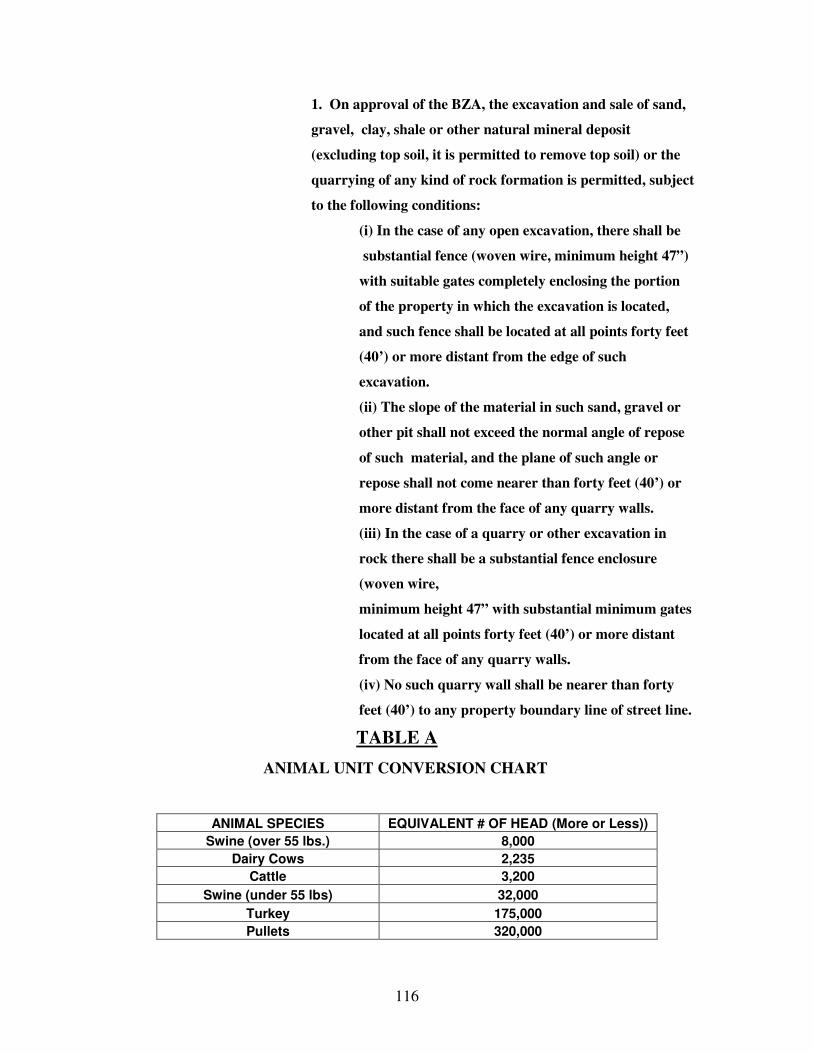
116
1. On approval of the BZA, the excavation and sale of sand,
gravel, clay, shale or other natural mineral deposit
(excluding top soil, it is permitted to remove top soil) or the
quarrying of any kind of rock formation is permitted, subject
to the following conditions:
(i) In the case of any open excavation, there shall be
substantial fence (woven wire, minimum height 47”)
with suitable gates completely enclosing the portion
of the property in which the excavation is located,
and such fence shall be located at all points forty feet
(40’) or more distant from the edge of such
excavation.
(ii) The slope of the material in such sand, gravel or
other pit shall not exceed the normal angle of repose
of such material, and the plane of such angle or
repose shall not come nearer than forty feet (40’) or
more distant from the face of any quarry walls.
(iii) In the case of a quarry or other excavation in
rock there shall be a substantial fence enclosure
(woven wire,
minimum height 47” with substantial minimum gates
located at all points forty feet (40’) or more distant
from the face of any quarry walls.
(iv) No such quarry wall shall be nearer than forty
feet (40’) to any property boundary line of street line.
TABLE A
ANIMAL UNIT CONVERSION CHART
ANIMAL SPECIES EQUIVALENT # OF HEAD (More or Less))
Swine (over 55 lbs.) 8,000
Dairy Cows 2,235
Cattle 3,200
Swine (under 55 lbs) 32,000
Turkey 175,000
Pullets 320,000

117
APPENDIX A
The following definitions and explanations shall apply to applications for Improvement Location Permits, the CFO/CAFO Site Scoring System, and the Regulated Livestock (A-3) Housing Scoring System.
1. CLEAN RECORD AWARD Points are earned by an applicant who has operated a CFO/CAFO in Indiana for at least five (5) years without any IDEM violations during the previous five (5) year period.
2. CLOSURE PLAN A closure plan sets forth the steps that will be implemented to remove and apply remaining manure and clean pits and/or lagoons if at any time a CFO/CAFO remains idle for twelve (12) consecutive months. An applicant is awarded points for submitting a copy of this plan when applying for a permit.
3. CONCENTRATED ANIMAL FEEDING OPERATIONS (CAFO) Concentrated Animal Feeding Operations or CAFO shall mean the definition as set forth in 327 IAC 5-4-3.
4. CONFINED FEEDING OPERATION (CFO) Confined Feeding Operation, or CFO, shall mean the definition as set forth in 327 IAC 16-2-5 and IC 13-11-2-40.
5. COUNTY VIOLATION An applicant who has had a violation under this ordinance for which a fine was imposed within the previous five (5) years receives a point deduction.
6. EXISTING LAND USE Points are awarded based on whether the land is currently being used for crops, pasture or woodland with greater points awarded for utilizing land that is not currently being used for agricultural activity.
7. HOMESTEAD AWARD An applicant is rewarded for placing a CFO/CAFO nearest to his or her own home (as compared to homes of adjoining property owners). The applicant must own the CFO/CAFO and the real estate on which the home is located or hold an ownership interest in the CFO/CAFO and real estate of at least ten percent (10%) held as a joint tenant, tenant in common, shareholder, partner, member, beneficiary or other legally recognized equity interest holder. Ownership by the applicant’s spouse and/or dependent child will also qualify applicant for points as if the ownership interest was applicant’s own.
118
8. IDEM/EPA VIOLATION In order to protect environmental interests and penalize repeat offenders, an applicant who has had a violation of state or federal CFO/CAFO regulations, including those regulated by the Indiana Department of Environmental Management (IDEM) and the Environmental Protection Agency (EPA), on record during the five (5) year period preceding this application, receives a point deduction. A violation shall be defined as a finding or order, by a governmental agency, such as IDEM or the EPA, or a court of law, in which the applicant as determined to be in violation of state or federal CFO/CAFO regulations. The applicant will be deemed to have such a violation if he or she holds an interest of at least ten percent (10%) in any CFO/CAFO or the real estate upon which it is located where the discharge occurred whether that interest is held as a joint tenant, tenant-in-common, shareholder, partner, member, beneficiary or any other legally recognized equity interest holder. Ownership by the applicant’s spouse and/or dependent child will also result in a deduction of points as if the ownership interest was the applicant’s own.
9. MANURE APPLICATION Manure may be applied by injection or land applied depending upon the type of manure as well as the topography and soil conditions of the application site. Injection is the preferred method, and more points are awarded to applicants who are able to utilize this method. Additional points are given if an attachment is used to cover the injection row in a single pass method. 10. NEIGHBOR NOTIFICATION At a minimum, applicant must notify all neighbors located within one-quarter (1/4) mile of the proposed CFO/CAFO building sites. In order to encourage open communication and positive neighbor relations, more points are awarded for notifying neighbors within one-half (1/2) mile or one (1) mile of the proposed location. Additionally, applicants must obtain written confirmation that they have notified all existing CFO/CAFO or IDEM-regulated operations located within one (1) mile of the proposed CFO/CAFO building sites. Personal notification is preferred for both of the aforementioned requirements. However, notice by certified mail is permitted when personal notification is not an available option.
11. NON-FARM HOME Any house that is not on the same parcel of land (as identified by tax parcel number) as the proposed CFO/CAFO. 12. NON-USE OF USABLE CRP GROUND In order to encourage applicants to use Conservation Reserve Program (“CRP”) land for site locations rather than land that is actively used for agricultural production, a point penalty is assessed to applicants who choose not to use their available CRP land. However, if the applicant’s CRP land is used as part of their Best Management Practices (“BMP”), such as grassed waterways, no point penalty will be imposed.

119
13. ODOR ABATEMENT An applicant may earn up to forty (40) points in each Tier for a total of eighty (80) points. Tier 1 Methods: Sprinkling of all gravel driveways Bio or biomass filters installed on appropriate exhaust fans Anaerobic Digester
Permeable cover or impermeable cover for manure storage and lagoon Liquid manure storage structure is covered Composting Surface of lagoon is aerated Other industry approved technology as approved by the BZA
Tier 2 Methods: Installation of Shelterbelt (mandatory) Windbreak walls Diet formulation (use of feeds that reduce odor and nutrient excretion) Manure additives Solids separation Other industry approved technology as approved by the BZA All CFO/CAFO’s must include a Shelterbelt regardless of which additional techniques are utilized. A shelterbelt shall be installed in accordance with NRCS standards. Driveway sprinkling may be done with emulsion oil, water or dust stay material similar to the material used by the highway department and should be repeated as frequently as is necessary for absorption.
14. PARCEL Contiguous real estate that is identified by a given tax parcel number shall be considered a parcel herein.
15. SECTION DENSITY Seven (7) levels are created based upon the number of non-farm homes located within a one-half (1/2) mile radius from the proposed site.
16. SEPARATION FROM HOUSE, PUBLIC USE FACILITY, CHURCH Applicants earn points based upon the separation distance from the proposed location of the CFO/CAFO facility to a house, public facility or church a “public use facility” shall include any facility located upon land owned by any federal, state, or local governmental or political entity which is operated to attract the public and allow them to congregate for significant periods of time. Public use facility shall include but not be limited to a park, picnic area, campground, lodge, shelter house, playground, lake, and swimming beach. A highway, road right-of- way, parking area, recreational trail and any other area used by the public for a
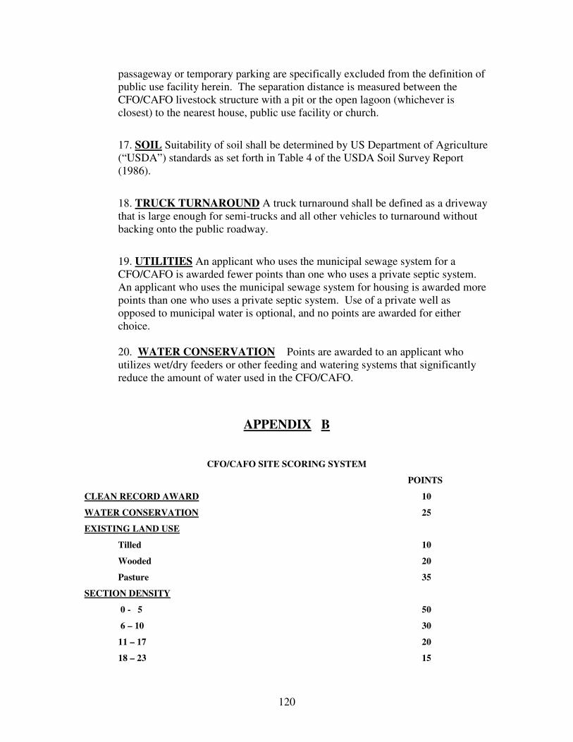
120
passageway or temporary parking are specifically excluded from the definition of public use facility herein. The separation distance is measured between the CFO/CAFO livestock structure with a pit or the open lagoon (whichever is closest) to the nearest house, public use facility or church.
17. SOIL Suitability of soil shall be determined by US Department of Agriculture (“USDA”) standards as set forth in Table 4 of the USDA Soil Survey Report (1986).
18. TRUCK TURNAROUND A truck turnaround shall be defined as a driveway that is large enough for semi-trucks and all other vehicles to turnaround without backing onto the public roadway.
19. UTILITIES An applicant who uses the municipal sewage system for a CFO/CAFO is awarded fewer points than one who uses a private septic system. An applicant who uses the municipal sewage system for housing is awarded more points than one who uses a private septic system. Use of a private well as opposed to municipal water is optional, and no points are awarded for either choice. 20. WATER CONSERVATION Points are awarded to an applicant who utilizes wet/dry feeders or other feeding and watering systems that significantly reduce the amount of water used in the CFO/CAFO.
APPENDIX B
CFO/CAFO SITE SCORING SYSTEM
POINTS
CLEAN RECORD AWARD 10
WATER CONSERVATION 25
EXISTING LAND USE
Tilled 10
Wooded 20
Pasture 35
SECTION DENSITY
0 - 5 50
6 – 10 30
11 – 17 20
18 – 23 15

121
24 – 38 10
39 – 49 5
50 + 0
UTILITIES
Municipal Sewer 15
Private Septic 50
SEPARATION FROM HOUSE/PUBLIC USE FACILITY/CHURCH
At least 250’ more than required by Developmental Standards 40
At least 500’ more than required by Developmental Standards 60
At least 750’ more than required by Developmental Standards 80
At least 1000’ more than required by Developmental Standards 120
1250’ or more than required by Developmental Standards 150
NON-USE OF USABLE CRP GROUND -50
TRUCK TURNAROUND 30
IDEM/EPA VIOLATION -150
COUNTY VIOLATION -50
HOMESTEAD AWARD 100
ODOR ABATEMENT
Tier 1 (20 points for the first method, and
5 points for each additional method up to a maximum of 40 points)
One method 20
Two methods 25
Three methods 30
Four methods 35
Five methods 40
Tier 2 (20 points for first method, and 5 points for each additional method up to
a maximum of 40 points)
One method 20

122
Two methods 25
Three methods 30
Four methods 35
Five methods 40
NEIGHBOR NOTIFICATION
Within one-quarter (1/4) mile (mandatory) 5
Within one-half (1/2) mile 15
Within one (1) mile 30
MANURE APPLICATION
Injection 40 Use of attachment with Injection 5 Land applied (incorporated within 24 hours) 25
CLOSURE PLAN 50
TOTAL SCORE _________/655
APPENDIX C
REGULATED LIVESTOCK (A-3) HOUSING SCORING SYSTEM
SOILS
SUITABLE 5
NOT SUITABLE 2
EXISTING LAND USE
TILLABLE 0
WOODED 3
PASTURED 5
SECTION DENSITY
0 – 5 0
6 – 10 1
11 – 17 3
18 – 23 5
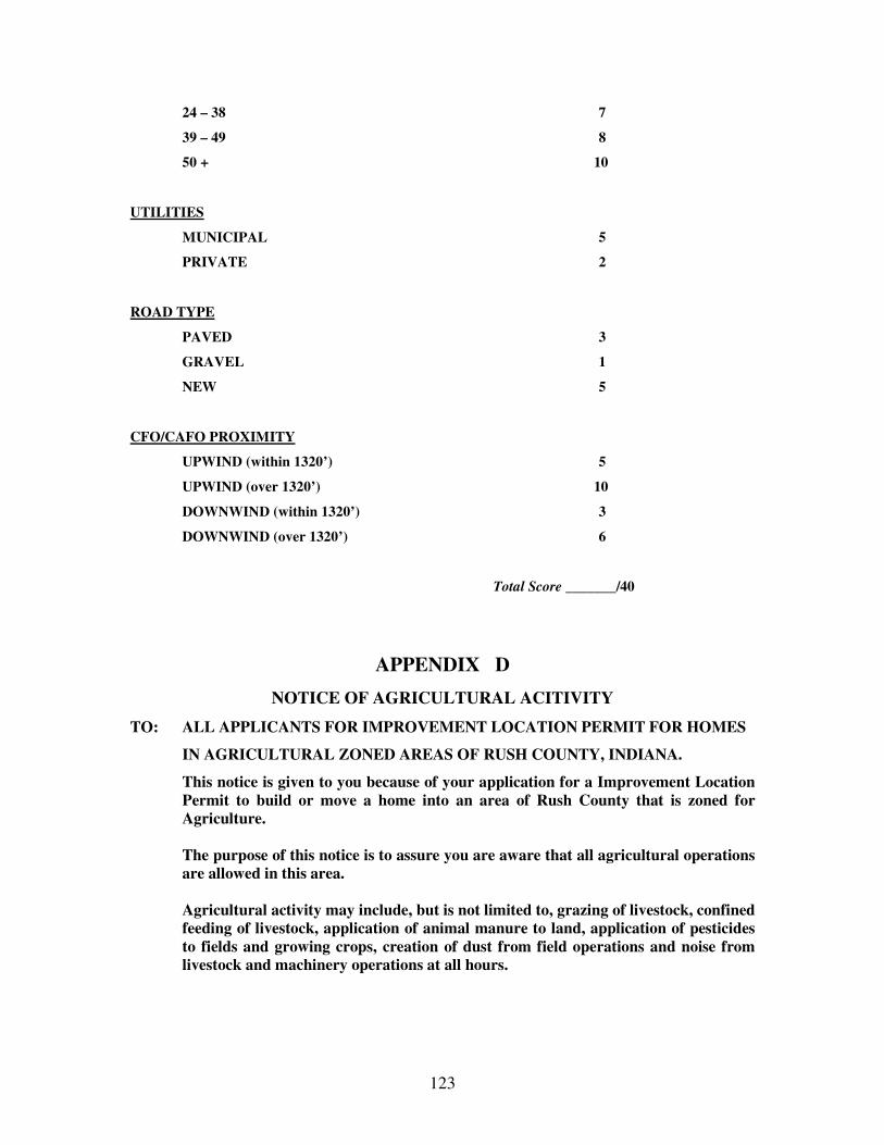
123
24 – 38 7
39 – 49 8
50 + 10
UTILITIES
MUNICIPAL 5
PRIVATE 2
ROAD TYPE
PAVED 3
GRAVEL 1
NEW 5
CFO/CAFO PROXIMITY
UPWIND (within 1320’) 5
UPWIND (over 1320’) 10
DOWNWIND (within 1320’) 3
DOWNWIND (over 1320’) 6
Total Score _______/40
APPENDIX D
NOTICE OF AGRICULTURAL ACITIVITY
TO: ALL APPLICANTS FOR IMPROVEMENT LOCATION PERMIT FOR HOMES
IN AGRICULTURAL ZONED AREAS OF RUSH COUNTY, INDIANA.
This notice is given to you because of your application for a Improvement Location Permit to build or move a home into an area of Rush County that is zoned for Agriculture.
The purpose of this notice is to assure you are aware that all agricultural operations
are allowed in this area. Agricultural activity may include, but is not limited to, grazing of livestock, confined
feeding of livestock, application of animal manure to land, application of pesticides to fields and growing crops, creation of dust from field operations and noise from livestock and machinery operations at all hours.

124
Single family dwellings are permitted uses of land in an Agricultural Zone, and this is not restricted to farm families. However, people who choose to live in these areas must understand that agricultural operations may be occurring nearby. You must also understand that Indiana has a “RIGHT TO FARM” law that protects farm operations form unwarranted nuisance suits by neighbors who move next to an existing farm operation. Farm operations do not constitute a nuisance so long as they are not negligently maintained, do not endanger human health and do not cause bodily injury to third parties. By signing this notice form you verify that you have received it, read it and understand it. You are not giving up the right to seek redress for negligence by individuals associated with a farm operation or by other residents of the area.
MY SIGNATURE CERTIFIES THAT I HAVE RECEIVED THIS NOTICE. I HAVE READ IT AND UNDERSTAND IT.
__________________________ __________________________ Printed Name Signature
__________________________ __________________________ Street Address Date
__________________________ __________________________
City, State, Zip Code Permit Number
7.12 Open land District (Flood Hazard Areas) (Amended effective 09-18-06)
Article 1
Statutory Authorization, Findings of Fact, Purpose and Objectives
Section A Statutory Authorization The Indiana Legislature has in IC 36-7-4 and IC 14-28-4 granted the power to local government units to control land use within their jurisdictions. Therefore, the Board of Commissioners of Rush County, the City Council of Rushville, the Town Board of Glenwood, and the Town Board of Carthage does hereby adopt the following floodplain management regulation.
125
Section B. Findings of Fact (1) The flood hazard areas of Rush County, the City of Rushville, and the Town of
Carthage are subject to periodic inundation which results in loss of life and property, health and safety hazards, disruption of commerce and governmental services, extraordinary public expenditures for flood protection and relief, and impairment of the tax base, all of which adversely affect the public health, safety, and general welfare.
(2) These flood losses are caused by the cumulative effect of obstructions in
floodplains causing increases in flood heights and velocities, and by the occupancy in flood hazard areas by uses vulnerable to floods or hazardous to other lands which are inadequately elevated, flood-proofed, or otherwise unprotected from flood damages.
Section C. Statement of Purpose It is the purpose of this ordinance to promote the public health, safety, and general welfare and to minimize public and private losses due to flood conditions in specific area by provisions designed to:
(1) Restrict or prohibit uses which are dangerous to health, safety, and property due to water or erosion hazards, which result in damaging increases in erosion or in flood heights or velocities;
(2) Require that uses vulnerable to floods, including facilities which serve such uses, be protected against flood damage at the time of initial construction;
(3) Control the alteration of natural floodplains, stream channels, and natural protective barriers which are involved in the accommodation of flood waters;
(4) Control filling, grading, dredging, and other development which may increase erosion or flood damage;
(5) Prevent or regulate the construction of flood barriers which will unnaturally divert floodwaters or which may increase flood hazards of other lands; and,
(6) Make federally subsidized flood insurance available for structures and their contents in Rush County, the City of Rushville, and the Towns of Glenwood and Carthage by fulfilling the requirements of the National Flood Insurance Program.
Section D. Objectives

126
The objectives of this ordinance are: (1) To protect human life and health
(2) To minimize expenditure of public money for costly flood control projects;
(3) To minimize the need for rescue and relief efforts associated with flooding and generally undertaken at the expense of the general public.
(4) To minimize prolonged business interruptions; (5) To minimize damage to public facilities and utilities such as water and gas
mains, electric, telephone, and sewer lines, streets, and bridges located in floodplains;
(6) To help maintain a stable tax base by providing for the sound use and development of flood prone area in such a manner as to minimize flood blight areas, and;
(7) To ensure that potential homebuyers are notified that property is in a flood area.
Article 2 Definitions
Unless specifically defined below, words or phrases used in this ordinance shall be interpreted so as to give them the meaning they have in common usage and to give this ordinance its most reasonable application. A zone means portions of the SFHA in which the principal source of flooding is runoff from rainfall, snowmelt, or combination of both. In A zones, floodwaters may move slowly or rapidly, but waves are usually not a significant threat to buildings. These area are labeled as Zone A, Zone AE, Zones A1-A30, Zone AO, Zone AH, Zone AR, and Zone A99 or a FIRM or FHBM. The definitions are presented below:
Zone A: Areas subject to inundation by the one-percent annual chance flood event. Because detailed hydraulic analyses have not been performed, no base flood elevation or depths are shown. Mandatory flood insurance purchase requirements apply. Zone AE and A1-30: Areas subject to inundation by the one-percent annual chance flood event determined by detailed methods. Base flood elevations are shown within these zones. Mandatory flood insurance purchase requirements apply. (Zone AE is on new and revised maps in place of Zones A1-30.) Zone AO: Areas subject to inundation by one-percent annual chance shallow flooding (usually sheet flow on sloping terrain) where average depths are between one and three feet. Average flood depths derived from detailed hydraulic analyses are shown within this zone. Mandatory flood insurance purchase requirements apply.

127
Zone AH: Areas subject to inundation by one-percent annual chance shallow flooding (usually areas of ponding) where average depths are 1-3 feet. Average flood depths derived from detailed hydraulic analyses are shown within this zone. Mandatory flood insurance purchase requirements apply. \ Zone AR: Areas that result from the decertification of a previously accredited flood protection system that is determined to be in the process of being restored to provide base flood protection. Mandatory flood insurance requirements apply. Zone A99: Areas subject to inundation by the one-percent annual chance flood event, but which will ultimately be protected upon completion of an under-construction Federal flood protection system. These are areas of special flood hazard where enough progress has been made on the construction of a protected system, such as dikes, dams, and levees, to consider it complete for insurance rating purposes. Zone A99 may only be used when the flood protection system has reached specified statutory progress toward completion. No base flood elevations or depths are shown. Mandatory flood insurance purchase requirements apply.
Accessory structure (appurtenant structure) means a structure that is located on the same parcel of property as the principal structure and the use which is incidental to the use of the principal structure. Accessory structures should constitute a minimal initial investment, may not be used for human habitation, and be designed to have minimal flood damage potential. Examples of accessory structures are detached garages, carports, storage sheds, pole barns, and hay sheds. Addition (to an existing structure) means any walled and roofed expansion to the perimeter of a structure in which the addition is connected by a common load-bearing wall other than a firewall. Any walled and roofed addition, which is connected by a firewall or is separated by independent perimeter load-bearing walls, is new construction. Appeal means a request for a review of the floodplain administrator’s interpretation of any provision of the ordinance or a request for a variance. Area of shallow flooding means a designated AO or AH Zone on the community’s Flood Insurance Rate Map (FIRM) with base flood depths from one to three feet where a clearly defined channel does not exist, where the path of flooding is unpredictable and indeterminate, and where velocity flow may be evident. Such flooding is characterized by ponding or sheet flow. Base Flood Elevation (BFE) means the elevation of the one-percent annual chance flood. Basement means that portion of a structure having its floor sub-grade (below ground level) on all sides.
128
Building – see “Structure.” Community means a political entity that has the authority to adopt and enforce floodplain ordinances for the area under its jurisdiction. Community Rating System (CRS) means a program developed by the Federal Insurance Administration to provide incentives for those communities in the Regular Program that have gone beyond the minimum floodplain management requirements to develop extra measures to provide protection from flooding. Critical facility means a facility for which even a slight chance of flooding might be too great. Critical facilities include, but not limited to, schools, nursing homes, hospitals, police, fire, and emergency response installations, installations which produce, use or store hazardous materials or hazardous waste. Development means any man-made change to improved or unimproved real estate including but not limited to:
(1) construction, reconstruction, or placement of a structure or any addition to a Structure; (2) installing a manufactured home on a site, preparing a site for a manufactured home or installing recreational vehicle on a site for more than 180 days; (3) installing utilities, erection of walls and fences, construction of roads, or similar projects; (4) construction of flood control structures such as levees, dikes, dams, channel improvements, etc.; (5) mining, dredging, filling, grading, excavation, or drilling operations; (6) construction and/or reconstruction of bridges or culverts; (7) storage of materials; or (8) any other activity that might change the direction, height, or velocity of flood or surface waters. “Development” does not include activities such as the maintenance of existing structures and facilities such as painting, re-roofing; resurfacing roads; or gardening, plowing, and similar agricultural practices that do not involved filling, grading, excavation, or the construction of permanent structures.
129
Elevated structure means a non-basement structure built to have the lowest floor elevated above the ground level by means of fill, solid foundation perimeter walls, pilings, or columns (posts and piers) Elevation Certificate is a certified statement that verifies a structure’s elevation information. Emergency Program means the first phase under which a community participates in the NFIP. It is intended to provide a first layer amount of insurance at subsidized rates on all insurable structures in that community before the effective date of the initial FIRM. Encroachment means the advance or infringement of uses, fill, excavation, buildings, permanent structures or development into a floodplain, which may impede or alter the flow capacity of a floodplain. Existing Construction means any structure for which the “start of construction” commenced before the effective date of the community’s first floodplain ordinance. Existing manufactured home park or subdivision means a manufactured home park or subdivision for which the construction of facilities for servicing the lots on which the manufactured homes are to be affixed (including the installation of utilities, the construction of streets, and either final site grading or the pouring of concrete pads) is completed before the effective date of the community’s first floodplain ordinance. Expansion to an existing manufactured home park or subdivision means the preparation of additional sites by the construction of facilities for servicing the lots on which the manufactured homes are to be affixed (including the installation of utilities, the construction of streets, and either final site grading or the pouring of concrete pads.) FEMA means the Federal Emergency Management Agency Five-hundred year flood (500-yer flood) means the flood that has a 0.2 percent chance of being equaled or exceeded in any year. Flood means a general and temporary condition of partial or complete inundation of normally dry land areas from the overflow, the unusual and rapid accumulation, or the runoff of surface waters from any source. Flood Boundary and Floodway Map (FBFM) means an official map on which the Federal Emergency Management Agency (FEMA) or the Federal Insurance Administration (FIA) has delineated the areas of flood hazards and regulatory floodway. Flood Hazard Boundary Map (FHBM) means an official map of a community, issued by FEMA, where the boundaries of the areas of special flood hazard have been identified as Zone A.

130
Flood Insurance Rate Map (FIRM) means an official map of a community, on which FEMA has delineated both the area of special flood hazard and the risk premium zones applicable to the community Flood Insurance Study (FIS) is the official hydraulic and hydrologic report provided by FEMA. The report contains flood profiles, as well as the FIRM, FBFM (where applicable), and the water surface elevation of the base flood. Floodplain means the channel proper and the areas adjoining any wetland, lake or watercourse which have been or hereafter may be covered by the regulatory flood. The floodplain includes both the floodway and the fringe districts. Floodplain management means the operation of an overall program of corrective and preventive measures for reducing flood damage and preserving and enhancing, where possible, natural resources in the floodplain, including but not limited to emergency preparedness plans, flood control works, floodplain management regulations, and open space plans. Floodplain management regulations means this ordinance and other zoning ordinances, subdivision regulations, building codes, health regulations, special purpose ordinances, and other applications of police power which control development in flood-prone areas. This term describes federal, state, or local regulations in any combination thereof, which provide standards for preventing and reducing flood loss and damage. Floodplain management regulations are also referred to as floodplain regulations, floodplain ordinance, flood damage prevention ordinance, and floodplain management requirements. Flood Protection Grade (FPG) is the elevation of the regulatory flood plus two feet at any given location in the SFHA (see “Freeboard”) Floodproofing (dry floodproofing) is a method of protecting a structure that ensures that the structure, together with attendant utilities and sanitary facilities, is watertight to the floodproofed design elevation with walls that are substantially impermeable to the passage of water. All structural components of these walls are capable of resisting hydrostatic and hydrodynamic flood forces, including the effects of buoyancy, and anticipated debris impact forces. Floodproofing certificate is a form used to certify compliance for non-residential structures as an alternative to elevating structures to or above the FPG. The certification must be by a Registered Professional Engineer or Architect. Floodway is the channel of a river or stream and those portions of the floodplains adjoining the channel which are reasonably required to efficiently carry and discharge the peak flood flow of the regulatory flood of any river or stream.

131
Freeboard means a factor of safety, usually expressed in feet above the BFE, which is applied for the purposes of floodplain management. It is used to compensate for the many unknown factors that could contribute to flood heights greater than those calculated for the base flood. Fringe is those portions of the floodplain lying outside the floodway. Functionally dependent facility means a facility which cannot be used for its intended purpose unless it is located or carried out in close proximity to water, such as a docking or port facility necessary for the loading and unloading of cargo or passengers, shipbuilding, ship repair, or seafood processing facilities. The term does not include long-term storage, manufacture, sales, or service facilities. Hardship (as related to variances of this ordinance) means the exceptional hardship that would result from a failure to grant the requested variance. The Board of Zoning Appeals requires that the variance is exceptional, unusual, and peculiar to the property involved. Mere economics or financial hardship alone is NOT exceptional. Inconvenience, aesthetic considerations, physical handicaps, personal preferences, or the disapproval of one’s neighbors likewise cannot, as a rule, qualify as an exceptional hardship. All of these problems can be resolved through other means without granting a variance, even if the alternative is more expensive, or requires the property owner to build elsewhere or put the parcel to a different use than originally intended. Highest adjacent grade means the highest natural elevation of the ground surface, prior to the start of construction, next to the proposed walls of a structure. Historic structure means any structure individually listed on the National Register of Historic Places or the Indiana State Register of Historic Sites and Structures. Increased Cost of Compliance (ICC) means the cost to repair a substantially damaged structure that exceeds the minimal repair cost and that is required to bring a substantially damaged structure into compliance with the local flood damage prevention ordinance. Acceptable mitigation measures are elevation, relocation, demolition, or any combination thereof. All renewal and new business flood insurance policies with effective dates on or after June 1, 1997, will include ICC coverage. Letter of Map Amendment (LOMA) means an amendment to the currently effective FEMA map that establishes that a property is not located in a SFHA. A LOMA is issued only by FEMA. Letter of Map Revision (LOMR) means an official revision to the currently effective FEMA map. It is issued by FEMA and changes flood zones, delineations, and elevation. Letter of Map Revision Based on Fill (LOMR-F) means an official revision by letter to an effective NFIP map. A LOMR-F provided FEMA’s determination concerning
132
whether a structure or parcel has been elevated on fill above BFE and excluded from SFHA. Lowest adjacent grade means the lowest elevation, after completion of construction, of the ground, sidewalk, patio, deck support, or basement entryway immediately next to the structure. Lowest floor means the lowest of the following: (1) the top of the lowest level of the structure; (2) the top of the basement floor; (3) the top of the garage floor, if the garage is the lowest level of the structure; (4) the top of the first floor of a structure elevated on pilings or pillars; (5) the top of the first floor of a structure constructed with a crawl space, provided that the lowest point of the interior grade is at or above the BFE and construction meets requirements of a 6.a; or (6) the top of the floor level of any enclosure, other than a basement, below an elevated structure where the walls of the enclosure provide any resistance to the flow of flood waters unless:
a). the walls are designed to automatically equalize the hydrostatic flood forces on the walls by allowing for the entry and exit of flood waters, by providing a minimum of two openings (in addition to doorways and windows) having a total net area of one (1) square inch for every square foot of enclosed area subject to flooding. The bottom of all such openings shall be no higher than one (1) foot above grade; and, b). such enclosed space shall be usable solely for the parking of vehicles and building access.
Manufactured home means a structure, transportable in one or more sections, which is built on a permanent chassis and is designed for use with or without a permanent foundation when attached to the required utilities. The term “manufactured home” does not include a “recreational vehicle.” Manufactured home park or subdivision means a parcel (or contiguous parcels) of land divided into two or more manufactured home lots for rent or sale. Map amendment means a change to an effective NFIP map that results in the exclusion from the SFHA of an individual structure or a legally described parcel of land that has been inadvertently included in the SFHA (i.e. no alterations of topography have occurred

133
since the date of the first NFIP map that showed the structure or parcel to be within the SFHA). Map panel number is the four-digit number followed by a letter suffix assigned by FEMA on a flood map. The first four digits represent the map panel, and the letter suffix represents the number of times the map panel has been revised. (The letter “A” is not used by FEMA, the letter “B” is the first revision.) Market value means the building value, excluding the land (as agreed to between a willing buyer and seller), as established by what the local real estate market will bear. Market value can be established by independent certified appraisal, replacement cost depreciated by age of building (actual cash value), or adjusted assessed values. Mitigation means sustained actions taken to reduce or eliminate long-term risk to people and property from hazards and their effects. The purpose of mitigation is two fold: to protect people and structures, and to minimize the cost of disaster response and recovery. National Flood Insurance Program (NFIP) is the federal program that makes flood insurance available to owners of property in participating communities nationwide through the cooperative efforts of the Federal Government and the private insurance industry. National Geodetic Vertical Datum (NGVD) as corrected in 1929 is a vertical control used as a reference for establishing varying elevations within the floodplain. New construction means any structure for which the “start of construction” commenced after the effective date of the community’s first floodplain ordinance. New manufactured home park or subdivision means a manufactured home park or subdivision for which the construction of facilities for servicing the lots on which the manufactured homes are to affixed (including at a minimum, the installation of utilities, the construction of streets, and either final site grading or the pouring of concrete pads) is completed on or after the effective date of the community’s first floodplain ordinance. North American Vertical Datum of 1988 (NAVD 88) as adopted in 1993 is a vertical control datum used as a reference for establishing varying elevations within the floodplain. Obstruction includes, but is not limited to, any dam, wail, wharf, embankment, levee, dike, pile, abutment, protection, excavation, canalization, bridge, conduit, culvert, building, wire, fence, rock, gravel, refuse, fill, structure, vegetation, or other material in, along, across or projecting into any watercourse which may alter, impede, retard, or change the direction and/or velocity of the flow of water, due to its location, its propensity to snare or collect debris carried by the flow of water, or its likelihood of being carried downstream.

134
One-hundred year flood (100-year flood) is the flood that has a one percent (1%) chance of being equaled or exceeded in any given year. Any flood zone that begins with the letter A is subject to the one-percent annual chance flood. See “Regulatory Flood”. One-percent annual chance flood is the flood that has a one percent (1%) chance of being equaled or exceeded in any given year. Any flood zone that begins with the letter A is subject to the one-percent annual chance flood. See “Regulatory Flood”. Participating community is any community that voluntarily elects to participate in the NFIP by adopting and enforcing floodplain management regulations that are consistent with the standards of the NFIP. Physical Map Revision (PMR) is an official republication of a community’s FEMA map to effect changes to base (1-percent annual chance) flood elevation, floodplain boundary delineations, regulatory floodways, and planimetric features. These changes typically occur as a result of structural works or improvements, annexations resulting in additional flood hazard areas, or correction to base flood elevations of SFHAs. Post-FIRM construction means construction or substantial improvement that started on or after the effective date of the initial FIRM of the community or after December 31, 1974, whichever is later. Pre-FIRM construction means construction or substantial improvement, which started on or before December 31, 1974, or before the effective date of the initial FIRM of the community, whichever is later. Probation is a means of formally notifying participating communities of violations and deficiencies in the administration and enforcement of the local floodplain management regulations. Public safety and nuisance, is defined as anything which is injurious to the safety or health of an entire community, neighborhood or any considerable number of persons, or lawfully obstructs the free passage or use, in the customary manner, or any navigable lake, or river, bay, stream, canal, or basin. Recreational vehicle means a vehicle which is (1) built on a single chassis; (2) 400 square feet or less when measured at the largest horizontal projections; (3) designed to be self-propelled or permanently towable by a light duty truck; and (4) designed primarily not for use as a permanent dwelling, but as a quarters for recreational camping, travel, or seasonal use. Regular program means the phase of the community’s participations in the NFIP where more comprehensive floodplain management requirements are imposed and higher amounts of insurance are available based upon risk zones and elevations determined in a FIS.

135
Regulatory flood means the flood having a one percent (1%) chance of being equaled or exceeded in any given year, as calculated by a method and procedure that is acceptable to and approved by the Indiana Department of Natural Resources and the Federal Emergency Management Agency. The regulatory flood elevation at any location is as defined in Article 3 (B) of the ordinance. The “Regulatory Flood: is also known by the term “Base Flood”, “One-Percent Annual Chance Flood”, and “100-Year Flood”. Repetitive loss means flood-related damages sustained by a structure on two separate occasions during a 10-year period ending on the date of the event for which the second claim is made, in which the cost of the repairing the flood damage, on the average, equaled or exceeded 25% of the market value of the structure at the time of each such flood event. Section 1316 is that section of the National Flood Insurance Act of 1968, as amended, which states that no new flood insurance coverage shall be provided for any property that the Administrator finds has been declared by a duly constituted state or local zoning authority or other authorized public body to be in violation of state or local laws, regulations, or ordinances that intended to discourage or otherwise restrict land development or occupancy in flood-prone areas. Special Flood Hazard Area (SFHA) means those lands within the jurisdiction of Rush County, the City of Rushville, the Town of Glenwood, and the Town of Carthage subject to inundation by the regulatory flood. The SFHAs of Rush County are generally identified as such on the Flood Insurance Rate Map of the County dated December 1, 1982, prepared by the Federal Emergency Management Agency. The SFHAs of the City of Rushville are generally identified as such on the Flood Insurance Rate Map prepared for the City of Rushville by the Federal Emergency Management Agency and dated November 3, 1982. The SFHAs of the Town of Carthage are generally identified as such on the Flood Insurance Rate Map prepared for the Town of Carthage by the Federal Emergency Management Agency and dated November 2, 1983. (These areas are shown on the FHBM or FIRM as Zone A, AE, A1-A30, AH, AR, A99, AO). Start of construction includes substantial improvement, and means the date the building permit was issued, provided the actual start of construction, repair, reconstruction, or improvement was within 180 days of the permit date. The actual start means the first placement or permanent construction of a structure (including a manufactured home) on a site, such as the pouring of slabs or footing, installation of piles, construction of columns, or any work beyond the stage of excavation for placement of a manufactured home on a foundation. Permanent constructions does not include land preparation, such as clearing, grading and filling; nor does it include the installation of streets and/or walkways; nor does it include excavation for a basement, footings, piers, foundations, or the erection of temporary forms; nor does it include the installation on the property of accessory buildings, such as garages or sheds not occupied as dwelling units or not part of the main structure. For substantial improvement, the actual start of construction means the first alteration of any wall, ceiling, floor, or other structural part of a building, whether or not that affects the external dimensions of the building.
136
Structure means a structure that is principally above ground and is enclosed by walls and a roof. The term includes a gas or liquid storage tank, a manufactured home, or a prefabricated building. The term also includes recreational vehicles to be installed on a site for more than 180 days. Substantial improvement means any reconstruction, rehabilitation, addition, or other improvement of a structure, the cost of which equals or exceeds 50 percent of the market value of the structure before the “start of construction” of the improvement. This term includes structures that have incurred “repetitive loss” or substantial damage” regardless of the actual repair work performed. The term does not include improvements of structures to correct existing violations of state or local health, sanitary, or safety code requirements or any alteration of a “historic structure”, provided that the alteration will not preclude the structures continued designation as a “historic structure”. Suspension means the removal of a participating community from the NFIP because the community has not enacted and/or enforced the proper floodplain management regulations required for participation in the NFIP. Variance is a grant of relief from the requirements of this ordinance, which permits construction in a manner otherwise prohibited by this ordinance where specific enforcement would result in unnecessary hardship. Violation means the failure of a structure or other development to be fully compliant with this ordinance. A structure or other development without the elevation, other certification, or other evidence of compliance required in this ordinance is presumed to be in violation until such time as that documentation is provided. Watercourse means a lake, river, creek, stream, wash, channel or other topographic feature on or over which waters flow at least periodically. Watercourse includes specifically designated areas in which substantial flood damage may occur. Water surface elevation means the height, in relation to the North American Vertical Datum of 1988 (NAVD 88) or National Geodetic Vertical Datum (NGVD) of 1929, (or other datum where specified) of floods of various magnitudes and frequencies in the floodplains of riverine areas. X zone means the area where the flood hazard is less than that in the SFHA. Shaded X zones shown on recent FIRMs (B zones on older FIRMS) designated areas subject to inundation by the flood with a 0.2 percent chance of being equaled or exceeded (the 500-year flood). Unshaded X zones (C zones on the older FIRMs) designate areas where the annual exceedance probability of flooding is less than 0.2 percent. Zone means a geographical area shown on the FHBM or FIRM that reflects the severity or type of flooding in the area.

137
Zone A (see definition for A zone) Zone B, C, and X means areas identified in the community as areas of moderate or minimal hazard from the principal source of flood in the area. However, buildings in these zones could be flooded by severe, concentrated rainfall coupled with inadequate local drainage systems. Flood insurance is available in participating communities but is not required by regulation in these zones. (Zone X is used on new and revised maps in place of Zones B and C.)
Article 3 General Provision
Section A. Lands to Which This Ordinance Applies This ordinance shall apply to all SFHAs within the jurisdiction of Rush County, the City of Rushville, and the Towns of Carthage and Glenwood. Section B. Basis for Establishing Regulatory Flood Data This ordinance’s protection standard is the regulatory flood. The best available regulatory flood data is listed below. Whenever a party disagrees with the best available data, the party submitting the detailed engineering study needs to replace existing data with better data and submit it to the Indiana Department of Natural Resources for review and approval.
1) The regulatory flood elevation, floodway, and fringe limits for the studied SFHAs of the Big Blue River, the Flatrock River, Six Mile Creek, Goose Creek, Three Mile Creek, and Charlottes Brook shall be delineated on the 100 year flood profiles in the Flood Insurance Study of Rush County dated June 1, 1982 and the corresponding FBFM dated December 1, 1982 prepared by the Federal Emergency Management Agency with the most recent date. (2) The regulatory flood elevation, floodway, and fringe limits for the studied SFHAs of the Flatrock River and Hodges Branch shall be as delineated on the 100 year flood profiles in the Flood Insurance Study of the City of Rushville dated May 3, 1982 and the corresponding FBFM dated November 3, 1982 prepared by the Federal Emergency Management Agency with the most recent date including the Letter of Map Revision dated July 20 2001, for the Flatrock River at Rushville, IN. (3) The regulatory flood elevation, floodway, and fringe limits for the studied SFHAs of the Big Blue River shall be as delineated on the 100 year flood profiles in the Flood Insurance Study of the Town of Carthage dated May 2, 1983 and the
138
corresponding FBFM dated November 2, 1983, prepared by the Federal Emergency Management Agency with the most recent date. (4) The regulatory flood elevation, floodway, and fringe limits for each of the remaining SFHAs delineated as “Zone A” on the Flood Insurance Rate Maps of Rush County, the City of Rushville, the and the Towns of Carthage and Glenwood shall be according to the best data available as provided by the Indiana Department of Natural Resources.
Section C. Establishment of Floodplain Development Permit A Floodplain Development Permit shall be required in conformance with the provisions of this ordinance prior to the commencement of any development activities in areas of special flood hazard. Section D. Compliance No structure shall hereafter be located, extended, converted or structurally altered within the SFHA without full compliance with the terms of this ordinance and other applicable regulations. No land or stream within the SFHA shall hereafter be altered without full compliance with the terms of the ordinance and other applicable regulation. Section E. Abrogation and Great Restrictions This ordinance is not intended to repeal, abrogate or impair any existing easements, covenants, or deed restrictions. However, where this ordinance and another conflict or overlap, whichever imposes the more stringent restrictions shall prevail. Section F. Discrepancy between Mapped Floodplain and Actual Ground Elevations
(1) In cases where there is a discrepancy between the mapped floodplain (SFHA) or the FIRM and the actual ground elevations, the elevation provided on the profiles shall govern. (2) If the elevation of the site in question is below the base flood elevation, that site shall be included in the SFHA and regulated accordingly. (3) If the elevation (natural grade) of the site in question is above the base flood elevation, that site shall be considered outside the SFHA and the floodplain regulations will not be applied. The property owner should be advised to apply for a LOMA.
139
Section G. Interpretation In the interpretation and application of this ordinance all provisions shall be: (1) Considered as minimum requirements (2) Liberally construed in favor of the governing body; and, (3) Deemed neither to limit nor repeal any other powers granted under state statutes. Section H. Warning and Disclaimer of Liability The degree of flood protection required by this ordinance is considered reasonable for regulatory purposes and is based on available information derived from engineering and scientific methods of study. Larger floods can and will occur on rare occasions. Therefore, this ordinance does not create any liability on the part of Rush County, the City of Rushville, the Town of Carthage, the Town of Glenwood, the Indiana Department of Natural Resources, or the State of Indiana, for any flood damage that results from reliance on this ordinance or any administrative decision made lawfully there under. Section I. Penalties for Violation Failure to obtain a Floodplain Development Permit in the SFHA or failure to comply with the requirements of a Floodplain Development Permit or conditions of a variance shall be deemed to be a violation of this ordinance. All violations shall be considered a common nuisance and be treated as such in accordance with the provisions of the Zoning Code for Rush County. All violations shall be punishable by a fine not exceeding $2,500.00 (1) A separate offense shall be deemed to occur for each day the violation continues to exist. (2) The Rush County Area Plan Commission shall inform the owner that any such violation is considered a willful act to increase flood damages and therefore may cause coverage by a Standard Flood Insurance Policy to be suspended.
(3) Nothing herein shall prevent the Rush County Area Plan Commission and/or the Board of Zoning Appeals from taking such other lawful action to prevent or remedy any violations. All costs connected therewith shall accrue to the person or persons responsible
Article 4 Administration
Section A. Designation of Administrator The County Commissioners of Rush County, the Common Council of the City of Rushville, and the Town Boards of the towns of Carthage and Glenwood, In, hereby appoints the Executive Director of the Rush County Area Plan Commission to administer
140
and implement the provisions of this ordinance and is herein referred to as the Floodplain Administrator. Section B. Permit Procedures Application for a Floodplain Development Permit shall be made to the Floodplain Administrator on forms furnished by him or her prior to any development activities, and may include, but not be limited to, the following plans in duplicate drawn to scale showing the nature, location, dimensions, and elevations of the area in question; existing or proposed structures, earthen fill, storage of materials or equipment, drainage facilities, and the location of the foregoing. Specifically the following information is required: (1) Application stage. a. A description of the proposed development; b. Location of the proposed development sufficient to accurately locate
property and structure in relation to existing roads and streams. c. A legal description of the property site; d. A site development plan showing existing and proposed development locations and existing and proposed land grades; e. Elevation of the top of the lowest floor (including basement) of all proposed buildings. Elevation should be in NAVD 88 or NGVD. f. Elevation (in NAVD88 or NGVD) to which any non-residential structure will be floodproofed; g. Description of the extent to which any watercourse will be altered or related as a result of proposed development, and;
(2) Construction stage. Upon placement of the lowest floor; or floodproofing, it shall be the duty
of the permit holder to submit to the Floodplain Administrator a certification of the NAVD 88 or NGVD elevation of the lowest floor or floodproofed elevation, as built. Said certification shall be prepared by or under the direct supervision of a registered land surveyor or professional engineer and certified by the same. When floodproofing is utilized for a particular structure said certification shall be prepared by or under the direct supervision of a professional engineer or architect and certified by same. Any work undertaken prior to submission of the certification shall be at the permit holder’s risk. (The Floodplain Administrator shall review the lowest floor and floodproofing elevation survey data submitted.) The permit holder shall correct deficiencies detected by such review before any further work is allowed to proceed. Failure to submit the survey or failure to make said corrections required, hereby, shall be cause to issue a stop-work order for the project.
Section C. Duties and Responsibilities of the Floodplain Administrator
141
The Floodplain Administrator and/or designated staff is hereby authorized and directed to enforce the provisions of this ordinance. The administrator is further authorized to render interpretations of this ordinance, which are consistent with its spirit and purpose. Duties and Responsibilities of the Floodplain Administrator shall include, but not limited to:
(1) Review all floodplain development permits to assure that the permit requirements of this ordinance have been satisfied. (2) Inspect and inventory damaged structures in SFHA and complete substantial damage determinations. (3) Ensure that construction authorization has been granted by the Indiana Department of Natural Resources for all development projects subject to Article 5, Section E and G (1) of this ordinance, and maintain a record of such authorization (either copy of actual permit or floodplain analysis/regulatory assessment.) (4) Ensure that all necessary federal or state permits have been received prior to issuance of the local floodplain development permit. Copies of such permits are to be maintained on file with the floodplain development permit. (5) Notify adjacent communities and the Stated Floodplain Coordinator prior to any alteration or relocation of a watercourse, and submit copies of such notifications to FEMA. (6) Maintain for public inspection and furnish upon request local permit documents, damaged structure inventories, substantial damage determinations, regulatory flood data, SFHA maps, Letters of Map Amendment (LOMA), Letters of Map Revision (LOMR), copies of DNR permits and floodplain analysis and regulatory assessments (letters of recommendation), federal permit documents, and “as built” elevation and floodproofing data for all buildings constructed subject to the ordinance. (7) Utilize and enforce all letters of Map Revision (LOMR) or Physical Map Revisions (PMR) issued by FEMA for the currently effective SFHA maps of the community. (8) Assure that maintenance is provided within the altered or relocated portion of said watercourse so that the flood-carrying capacity is not diminished. (9) Verify and record the actual elevation of the lowest floor (including basement) of all new or substantial improved structures, in accordance with Article 4, Section B.
142
(10) Verify and record the actual elevation to which any new or substantially improved structures have been floodproofed, in accordance with Article 4, Section B. (11) Review certified plans and specifications for compliance. (12) Stop Work Orders a). Upon notice from the Floodplain Administrator, work on any building, structure or premises that is being done contrary to the provisions of this ordinance shall immediately cease. b). Such notice shall be in writing and shall be given to the owner of the property. Or to his agent, or to the person doing the work, and shall state the conditions under which work may be resumed. (13) Revocation of Permits a. The Floodplain Administrator may revoke a permit or approval, issued under the provisions of the ordinance, in cases where there has been any false statement or misrepresentation as to the material fact, in the application or plans on which the permit or approval was based. b. The Floodplain Administrator may revoke a permit upon determination by the Floodplain Administrator that the construction, erection, alteration, repair, moving, demolition, installation, or replacement of the structure for which the permit was issued is in violation of, or not in conformity with, the provisions of this ordinance.
Article 5
Provisions for Flood Hazard Reduction
Section A. General Standards
In all SFHAs the following provisions are required:
(1) New construction and substantial improvements shall be anchored to prevent flotation, collapse or lateral movement of the structure;
(2) Manufactured homes shall be anchored to prevent flotation, collapse, or lateral
movement. Methods of anchoring may include, but not limited to, use of over-the-top or frame ties to ground anchors. This standard shall be in addition to and consistent with applicable state requirements for resisting wind forces;

143
(3) New construction and substantial improvements shall be constructed with materials and utility equipment resistant to flood damage below the FPG;
(4) New construction and substantial improvements shall be constructed by methods
and practices that minimize flood damage; (5) Electrical, heating, ventilation, plumbing, air conditioning equipment and other
service facilities shall be designed and/or located so as to prevent water from entering or accumulating within the components during conditions of flooding;
(6) New and replacement water supply systems shall be designed to minimize or
eliminate infiltration of flood waters into the system. (7) New and replacement sanitary sewage systems shall be designed to minimize or
eliminate infiltration of flood waters into the system. (8) On-site water disposal systems shall be located and constructed to avoid
impairment to them or contamination from them during flooding. (9) Any alteration, repair, reconstruction or improvements to a structure that is in
compliance with the provisions of the ordinance shall meet the requirements of the “new construction” as contained in the ordinance, and,
(10) Any alteration, repair, reconstruction, or improvement to a structure that is not in compliance with the provisions of this ordinance, shall be undertaken only if said non-conformity is not further, extended, or replaced. Section B. Specific Standards. In all SFHAs, the following provisions are required:
(1) In addition to the requirements of Article 5, Section A, all structures to be located in the SFHA shall be protected from flood damage below the FPG. This building protection requirement applies to the following situations:
a. Construction or placement of any new structure having a floor area greater than 400 square feet; b. Structural alterations made to:
(i) an existing (previously unaltered structure), the cost of which equals or exceeds 50% of the value of the pre-altered structure (excluding the value of the land); (ii) any previously altered structure.

144
c. Reconstruction or repairs made to a damaged structure that are valued at more than 50% of the market value of the structure (excluding the value of the land) before damage occurred; d. Installing a travel trailer or recreational vehicle on a site for more than 180 days; e. Installing a manufactured home on a new site or a new manufactured home on an existing site. This ordinance does not apply to returning the existing manufactured home to the same site it lawfully occupied before it was removed to avoid flood damage, and f. Reconstruction or repairs made to a repetitive loss structure.
(2) Residential Construction. New construction or substantial improvement of any residential structure (or manufactured home) shall have the lowest floor,
including the basement, at or above the FPG (two feet above the base flood elevation). Should solid foundation perimeter walls be used to elevate a structure, openings sufficient to facilitate the unimpeded movements of floodwaters shall be provided in accordance with the standards of Article 5, Section B (4).
(3) Non-Residential Construction. New construction or substantial improvement
of any commercial, industrial, or non-residential structure (or manufactured) shall have the lowest floor, including basement, elevated to or above the FPG (two feet above the base flood elevation). Structures located in all “A Zones” may be floodproofed in lieu of being elevated if done in accordance with the following:
a. A Registered Professional Engineer or Architect shall certify that the structure has been designed so that below the FPG the structure and attendant utility facilities are watertight and capable of resisting the effects of the regulatory flood. The structure design shall take into account flood velocities, duration, rate of rise, hydrostatic pressures, and impacts from debris or ice. Such certification shall be provided to the official as set forth in Article 4, Section C (10). b. Floodproofing measures shall be operable without human intervention and without an outside source of electricity.
(4) Elevated Structures. New construction or substantial improvements of elevated structures that included fully enclosed areas formed by foundation and other exterior walls below the base flood elevations shall be designed to preclude finished living space and designed to allow for the entry and exit of floodwaters to automatically equalize hydrostatic flood forces on exterior walls.
145
a. Designs for complying with this requirement must either be certified by a professional engineer or architect or meet the following minimum criteria:
(i) provide a minimum of two openings having a total net area of not less than one square inch for every square foot of enclosed area subject to flooding. (ii) the bottom of all openings shall be no higher than one foot above foundation interior grade (which must be equal to or higher in elevation than the exterior foundation grade); and (iii) openings may be equipped with screens, louvers, valves or other coverings or devices provided they permit the automatic flow of floodwaters in both directions. (iv) access to the enclosed area shall be the minimum necessary to allow for parking for vehicles (garage door) or limited storage of maintenance equipment used in connection with the premises (standard exterior door) or entry to the living area (stairway or elevator); and (v) the interior portion of such enclosed area shall not be partitioned or finished into separate rooms. (vi) portions of the building below the flood protection grade must be constructed with materials resistant to flood damage.
(5) Structures Constructed on Fill. A residential or nonresidential structure may
be constructed on a permanent land fill in accordance with the following: a. The fill shall be placed in layers no greater that 1-foot deep before
compacting to 95% of the maximum density obtainable with the Standard Proctor Test method. b. The fill should extend at least ten feet beyond the foundation of the structure before sloping below the FPG. c. The fill shall be protected against erosion and scour during flooding by vegetative cover, riprap, or bulkheading. If vegetative cover is used, the slopes shall be no steeper than 3 horizontal to 1 vertical. d. The fill shall not adversely affect the flow of surface drainage from or onto neighboring properties. e. The top of the lowest floor including basements shall be at or above the FPG.
(6) Standards for Structures Constructed with a Crawlspace. A residential or nonresidential structure may be constructed with a crawlspace located below the flood protection grade provided that the following conditions are met:
146
a. The building must be designed and adequately anchored to resist flotation, collapse, and lateral movement of the structure resulting from hydrodynamic and hydrostatic loads, including the effects of buoyancy, and: b. Any enclosed area below the flood protection grade shall have openings that equalize hydrostatic pressures by allowing for the automatic entry and exit of floodwaters. Provide a minimum of two openings having a total net area of not less than one square inch for every one square foot of enclosed area. The bottom of the openings shall be no more than one foot above grade; and c. The interior grade of the crawlspace must be at or above the base flood elevation; and d. The interior height of the crawlspace measured from the interior grade of the crawlspace to the top of the foundation wall must not exceed four feet at any point; and e. An adequate drainage system must be installed to remove floodwaters from the interior area of the crawlspace within a reasonable period of time after a flood event; and f. Portions of the building below the flood protection grade must be constructed with materials resistant to flood damage; and g. Utility systems within the crawlspace must be elevated above the flood protection grade.
(7) Standards for Manufactured Homes and Recreational Vehicles. Manufactured
homes and recreational vehicles to be installed or substantially improved on a site for more than 180 days must meet one of the following requirements:
a. The manufactured home shall be elevated on a permanent foundation such that the lowest floor shall be at or above the FPG and securely anchored to an adequately anchored foundation system to resist flotation, collapse, and lateral movement. This requirement applies to all manufactured homes to be placed on a site; (i) outside a manufactured home park or subdivision; (ii) in a new manufactured home park or subdivision;
(iii) in an expansion to an existing manufactured home park or subdivision; or (iv) in an existing manufactured home park or subdivision on

147
which a manufactured home has incurred “substantial damage” as a result of a flood. b. The manufactured home shall be elevated so that the lowest floor of
the manufactured home chassis is supported by reinforced piers or other foundation elevations that are no less than 36 inches in height above grade and be securely anchored to an adequately anchored foundation system to resist flotation, collapse, and lateral movement. This requirement applies to all manufactured homes to be placed on a site in an existing manufactured home park or subdivision that has not been substantially damaged by a flood. c. Recreational vehicles placed on a site shall either: (i) be on site for less than 180 days; and, (ii) be fully licensed and ready for highway use (defined as being
on its wheels or jacking system, is attached to the site only by quick disconnect type utilities and security devices, and has no
permanently attached additions); or
(iii) meet the requirements for “manufactured home” as stated earlier in this section.
Section C. Standards for Subdivision Proposals (1) All subdivision proposals shall be consistent with the need to minimize flood
damage. (2) All subdivision proposals shall have public utilities and facilities such as
sewer, gas, electric, and water systems located and constructed to minimize flood damage.
(3) All subdivision proposals shall have adequate drainage provided to reduce
exposure to flood hazards, and, (4) Base flood elevation data shall be provided for subdivision proposals and
other proposed development (including manufactured home parks and subdivisions), which is greater than the lesser of fifty lots or five acres.
Section D. Critical Facility. Construction of new critical facilities shall be, to the extent possible, located
outside the limits of the SFHA. Construction of new critical facilities shall be permissible within the SFHA is no feasible alternative site is available. Critical facilities constructed within the SFHA shall have the lowest floor elevated to or
148
above the FPG at the site. Floodproofing and sealing measures must be taken to ensure that toxic substances will not be displaced by or released into floodwaters. Access route elevated to or above the FPG shall be provided to all critical facilities to the extent possible.
Section E. Standards for Identified Floodways. Located within SFHAs, established in Article 3, Section B. are areas designated
as floodways. The floodway is an extremely hazardous area due to the velocity of floodwaters, which carry debris, potential projectiles, and has erosion potential. If the site is in an identified floodway, the Floodplain Administrator shall require the applicant to forward the application, along with all pertinent plans and specifications, to the Indiana Department of Natural Resources and apply for a permit for construction in a floodway. Under the provisions of IC 14-28-1, a permit for construction in a floodway from the Indiana Department of Natural Resources is required prior to the issuance of a local building permit for an excavation, deposit, construction or obstruction activity located in the floodway. This includes land preparation activities such as filling, grading, clearing, paving, etc, undertaken before the actual start of construction of the structure. However, it does exclude non-substantial additions/improvements to existing (lawful) residences in a non-boundary river floodway. (IC 14-28-1-26 allows construction of non-substantial additions/improvements to residences in a non-boundary river floodway without obtaining a permit for construction in a floodway from the Indiana Department of Natural Resources. Please note that if fill is needed to elevate an addition above the existing grade, prior approval (construction in a floodway permit) for the fill is required from the Indiana Department of Natural Resources.)
No action shall be taken by the Floodplain Administrator until a permit (when
applicable) has been issued by the Indiana Department of Natural Resources granting approval for construction in a floodway. Once a permit for construction in a floodway has been issued by the Indiana Department of Natural Resources, the Floodplain Administrator may issue the local Floodplain Development Permit, provided the provisions contained in Article 5 of this ordinance has been met. The Floodplain Development Permit cannot be less restrictive than the permit for construction in a floodway issued by the Indiana Department of Natural Resources. However a community’s more restrictive regulations (if any) shall take precedence.
No development shall be allowed which acting alone or in combination with existing or future development will increase the regulatory flood more than 0.14 of one foot. For all projects involving channel modifications of fill (including levees) the Rush County Area Plan Commission shall submit the data and request that the Federal Emergency Management Agency revise the regulatory flood data.

149
Section F. Standards for Identified Fringe. If the site is located in an identified fringe, then the Floodplain Administrator may issue the local Floodplain Development Permit provided the provisions contained in Article 5 of this ordinance have been met. The key provision is that the top of the lowest floor of any new or substantially improved structure shall be at or above the FPG. Section G. Standards for SFHAs Without Established Base Flood Elevation and/or Floodways/Fringes. (1) Drainage area upstream of the site is greater than one square mile: If the site is in an identified floodplain where the limits of the floodway
and fringe have not yet been determined, and the drainage area upstream of the site is greater than one square mile, the Floodplain Administrator shall require the applicant to forward the application, along with all the pertinent plans and specifications, to the Indiana Department of Natural Resources for review and comment. No action shall be taken by the Floodplain Administrator until either a permit for construction in the floodway or a floodplain analysis/regulatory assessment citing the 100 year flood elevation and the recommended Flood Protection Grade have been received from the Indiana Department of Natural Resources. Once the Floodplain Administrator has received the proper construction in a floodway permit or floodplain analysis/regulatory assessment approving the proposed development, a Floodplain Development Permit may be issued provided the conditions of the Floodplain Development Permit are not less restrictive than the conditions received from the Indiana Department of Natural Resources and the provisions contained in Article 5 of this ordinance have been met.
(2) Drainage area upstream of the site is less than one square mile: If the site is in an identified floodplain where the limits of the floodway and fringe have not yet been determined and the drainage area upstream of
the site is less than one square mile, the Floodplain Administrator shall require the applicant to provide an engineering analysis showing the limits of the floodway, fringe and 100-year flood elevation for the site.
Article 6
150
Variance Procedures Section A. Designation of Variance and Appeals Board The Board of Zoning Appeals as established by the County Commissioners of Rush County, the Common Council of the City of Rushville, and the Town Boards of Glenwood and Carthage, shall hear and decide appeals and requests for variances from requirements of this ordinance. Section B. Duties of Variance and Appeals Board The board shall hear and decide appeals when it is alleged an error in any requirement, decision, or determination is made by the Floodplain Administrator in the enforcement or administration of this ordinance. Any person aggrieved by the decision of the board may appeal such decision to the Rush County Circuit Court, as provided for in Indiana Statutes. Section C. Variance Procedures In passing upon such applications, the Board of Zoning Appeals shall consider all technical evaluations, all relevant factors, all standards specified in other sections of this ordinance, and; (1) The danger of life and property due to flooding or erosion damage; (2) The susceptibility of the proposed facility and its contents to flood damage and the effect of such damage on the individual owner; (3) The importance of the services provided by the proposed facility to the community; (4) The necessity to the facility of a waterfront location, where applicable; (5) The availability of alternative locations for the proposed use which are not subject to flooding or erosion damage; (6) The compatibility of the proposed use with existing and anticipated development; (7) The relationship of the proposed use to the comprehensive plan and floodplain management program for that area; (8) The safety of access to the property in times of flood for ordinary and emergency vehicles;

151
(9) The expected height, velocity, duration, rate of rise, and sediment of transport of the floodwaters at the site; and (10) The costs of providing governmental services during and after flood conditions, including maintenance and repair of public utilities and facilities such as sewer, gas, electrical, water systems, streets and bridges. Section D. Conditions for Variances (1) Variances shall only be issued when there is: a). A showing of good and sufficient cause;
b). A determination that failure to grant the variance would result in exceptional hardship; and,
c). A determination that the granting of a variance will not result in increased flood heights, additional threats to public safety, extraordinary public expense, create nuisances, cause fraud or victimization of the public, or conflict with existing laws or ordinances.
(2) No variance for a residential use within a floodway subject to Article 5, Section E or Section G (1) of this ordinance may be granted. (3) Any variance granted in a floodway subject to Article 5, Section E or Section G (1) of this ordinance will require a permit from the Indiana Department of Natural Resources. (4) Variances to the Provisions for Flood Hazard Reduction of Article 5, Section B, may be granted only when a new structure is to be located on a lot of one- half acre or less in size, contiguous to and surrounded by lots with existing structures constructed below the flood protection grade. (5) Variances shall only be issued upon a determination that the variance is the minimum necessary, considering the flood hazard to afford relief. (6) Variances may be granted for the reconstruction or restoration of any structure individually listed on the National Register of Historic Places or the Indiana State Register of Historic Sites and Structures. (7) Any application to whom a variance is granted shall be given written notice specifying the difference between the base flood elevation and the elevation to which the lowest floor is to be built and stating that the cost of the flood insurance will be commensurate with the increased risk resulting from the reduced lowest floor elevation (See Section E).

152
(8) The Floodplain Administrator shall maintain the records of appeal actions and report any variances to the Federal Emergency Management Agency or the Indiana Department of Natural Resources upon request. (See Section E). Section E. Variance Notification Any applicant to whom a variance is granted shall be given written notice over the signature of the floodplain administrator that: (1) The issuance of a variance to construct a structure below the base flood elevation will result in increased premium rates for flood insurance up to amounts as high as $25 for $100 of insurance coverage; and, (2) Such construction below the base flood level increases risks to life and property.
The Floodplain Administrator will maintain a record of all variance actions, including justification for their issuance, and report such variances issued in the community’s biennial report submission to the Federal Emergency Management Agency. Section F. Historical Structure Variances may be issued for the repair or rehabilitation of “historic structures” upon a determination that the proposed repair or rehabilitation will not preclude the structure’s continued designation as an “historic structure” and the variance is the minimum to preserve the historic character and design of the structure. Section G. Special Conditions Upon the consideration of the factors listed in Article 6, and the purposes of this ordinance, the Board of Zoning Appeals may attach such conditions to the granting of variances as it deems necessary to further the purposes of this ordinance.
Article 7 Severability
If any section, clause, sentence, or phrase of the Ordinance is held to be invalid or unconstitutional by any court of competent jurisdiction, then said holding shall in no way effect the validity of the remaining portions of the Ordinance.
Article 8
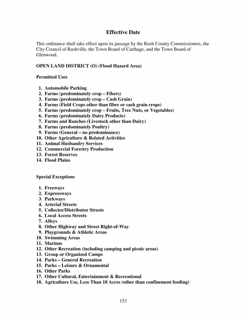
153
Effective Date This ordinance shall take effect upon its passage by the Rush County Commissioners, the City Council of Rushville, the Town Board of Carthage, and the Town Board of Glenwood.
OPEN LAND DISTRICT (O) (Flood Hazard Area)
Permitted Uses 1. Automobile Parking 2. Farms (predominately crop – Fibers) 3. Farms (predominately crop – Cash Grain) 4. Farms (Field Crops other than fiber or cash grain crops) 5. Farms (predominately crop – Fruits, Tree Nuts, or Vegetables) 6. Farms (predominately Dairy Products) 7. Farms and Ranches (Livestock other than Dairy) 8. Farms (predominately Poultry) 9. Farms (General – no predominance) 10. Other Agriculture & Related Activities 11. Animal Husbandry Services 12. Commercial Forestry Production 13. Forest Reserves 14. Flood Plains Special Exceptions 1. Freeways 2. Expressways 3. Parkways 4. Arterial Streets 5. Collector/Distributor Streets 6. Local Access Streets 7. Alleys 8. Other Highway and Street Right-of-Way 9. Playgrounds & Athletic Areas 10. Swimming Areas 11. Marinas 12. Other Recreation (including camping and picnic areas) 13. Group or Organized Camps 14. Parks – General Recreation 15. Parks – Leisure & Ornamental 16. Other Parks 17. Other Cultural, Entertainment & Recreational 18. Agriculture Use, Less Than 10 Acres (other than confinement feeding)

154
19. Forestry Service 20. Other Forestry Activities 21. Fisheries and Marine Products 22. Other Fishery Activities and Related Services 23. Wind Energy Conversion Systems
SECTION 8: ADMINISTRATION AND ENFORCEMENT- IMPROVEMENT LOCATION PERMITS AND CERTIFICATES OF ZONING COMPLIANCE 8.1 Administrative and Enforcement The Executive Director designated by the Area Plan Commission shall Administer and enforce this ordinance. He may be provided with the assistance of such other persons as the Area Plan Commission may direct. If the Executive Director shall find that any of the provisions of this ordinance are being violated, he shall notify in writing the person responsible for such violations, indicating the nature of the violation and ordering the action necessary to correct it. He shall order discontinuance of illegal use of land, buildings, or structures; removal of illegal buildings or structures or of illegal additions, alterations, or structural changes; discontinuance of any illegal work being done; or shall take any other action authorized by this ordinance to ensure compliance with or to prevent violation of its provisions. 8.2 Improvement Location Permits Required
No building or other structure shall be erected, moved, added to, or structurally altered without a permit therefore, issued by the Executive Director. No improvement location permit shall be issued by the Executive Director except in conformity with the provisions of this ordinance, unless he receives a written order from the Board of Zoning Appeals in the form of an administrative review, special exception, or variance as provided by this ordinance.
8.3 Application for Improvement Location Permit
All applications for improvement location permits shall be accompanied by plans in triplicate drawn to scale, showing the actual dimensions and shape of the lot(s) to be built upon; the exact sizes and locations on the lot(s) of buildings already existing, if any, and the location and dimensions of the proposed building(s) or alterations. The application shall include such other information as lawfully may
155
be required by the Executive Director, including existing or proposed building or alteration; existing or proposed uses of the building and land; the number of families, housekeeping units, or rental units the building is designed to accommodate; conditions existing on the lot; and such other matters as may be necessary to determine conformance with, and provide for the enforcement of, this ordinance. One copy of the plans shall be returned to the applicant by the Executive Director, after he shall have marked such copy either as approved or disapproved and attested to same by his signature on such copy. The original and one copy of the plans, similarly marked, shall be retained by the Executive Director.
8.4 Certificates of Zoning Compliance for New, Altered, or Non-Conforming Uses
It shall be unlawful to use or occupy or permit the use of occupancy of any building or premises, or both, or part thereof hereafter created, erected, changed,
converted, or wholly or partly altered or enlarged in its use or structure until a certificate of zoning compliance shall have been issued therefore by the Executive Director stating that the proposed use of the building or land conforms to the requirements of this ordinance. No non-conforming structure or use shall be renewed, changed, or extended until a certificate of zoning compliance shall have been issued by the Executive Director. The certificate of zoning compliance shall state specifically wherein the non-conforming use differs from the provisions of this ordinance. (As amended effective 02-01-88) No permit for erection, alteration, moving, or repair of any building shall be issued until an application has been made for a certificate of zoning compliance, and the certificate shall be issued in conformity with the provisions of this ordinance upon completion of the work. A temporary certificate of zoning compliance may be issued by the Executive Director for a period not exceeding six months during alterations or partial occupancy of a building pending its completion, provided that such temporary certificate may include such conditions and safeguards as will protect the safety of the occupants and the public. The Executive Director shall maintain a record of all certificates of zoning compliance, and a copy shall be furnished upon request to any person. Failure to obtain a certificate of zoning compliance shall be a violation of this ordinance and punishable under Section 16 of this ordinance. Certificates of Zoning Compliance shall be issued by the Executive Director. 8.5 Expiration of Improvement Location Permit
If the work described in any improvement location permit has not begun within

156
90 days from the date of the issuance thereof, said permit shall expire; it shall be cancelled by the Executive Director; and written notice thereof shall be given to the persons affected. Debris at construction sites shall be removed at least once a week and weeds shall not exceed two feet in height. (As amended effective 08-09-93) If the work described in any improvement location permit has not been substantially completed within one year of the date of issuance thereof, said permit shall expire and be cancelled by the Executive Director and written notice thereof shall be given to the persons affected, together with notice that further work as described in the cancelled permit shall not proceed unless and until a new improvement location permit has been obtained.
8.5.1 Revocation of Improvement Location Permit If the Improvement Location Permit has been issued based upon false, incomplete
or inaccurate information provided by the applicant, the Executive Director may revoke the Improvement Location Permit by sending Certified Mail notice of the reason for such revocation.
8.6 Construction and Use to be as Provided in Applications, Plans, Permits, and Certificates of Zoning Compliance Improvement Location Permits or Certificates of Zoning Compliance issued on
the basis of plans and applications approved by the Executive Director authorize only the use, arrangement, and construction set forth in such approved plans and applications, and no other use, arrangement, or construction. Use, arrangement, or construction at variance with that authorized shall be deemed a violation of this ordinance, and punishable as provided in Section 16 hereof.
8.7 National Flood Insurance Program Regulations The Executive Director during his review of Improvement Location Permits shall assure that all NFIP regulations pertaining to State and Federal permits, building permit review procedures, subdivision review procedures, utility construction, record keeping (lowest floor elevations including basements), water-course alteration and maintenance and mobile home tie downs have been met. The regulations can be found in Federal Regulations CFR 44, Chapter 60.3 (d).\
SECTION 9: BOARD OF ZONING APPEALS 9.1 Proceedings of the Board of Zoning Appeals The Board of Zoning Appeals shall adopt rules necessary to the conduct of its affairs and in keeping with the provisions of this ordinance. Meetings shall be
157
held at the call of the chairman and at such times as the Board may determine. The chairman, or in his absence the acting chairman, may administer oaths and compel the attendance of witnesses. All meetings shall be open to the public.
The Board of Zoning Appeals shall keep minutes of its proceedings, showing the vote of each member upon each question, or if absent or failing to vote indicating such fact, and shall keep records of its examinations and other official actions, all of which shall be a public record and be immediately filed in the office of the Board.
9.2 Hearings; Appeals; Notice Appeals to the Board of Zoning Appeals concerning interpretation or administration of this ordinance may be taken by any person aggrieved or by any officer or bureau of the governing body of the area affected by any decision of the Executive Director. Such appeals shall be taken within a reasonable time, not to exceed 30 days by filing with the Executive Director and with the Board of Zoning Appeals a notice of appeal specifying the grounds thereof. The Executive Director shall forthwith transmit to the Board all papers constituting the record upon which the action appealed from was taken. (As amended effective 02-01-88)
The Board of Zoning Appeals shall fix a reasonable time for the hearing of appeal, give public notice thereof as well as due notice to the parties of interest, and decide the same within a reasonable time. At the hearing, any party may appear in person or by agent or attorney.
9.3 Stay of Proceedings An appeal stays all proceedings in furtherance of the action appealed from, unless the Executive Director from whom the appeal is taken certifies to the Board of Zoning Appeals after the notice of appeal is filed with him, that by reason of facts stated in the certificate, a stay would, in his opinion, cause imminent peril to life and property. In such case, proceedings shall not be stayed other than by a restraining order which may be granted by the Board of Zoning Appeals or by a court of record on application, on notice to the Executive Director from whom the appeal is taken and on due cause shown.
SECTION 10: THE BOARD OF ZONING APPEALS: POWERS AND DUTIES
The Board of Zoning Appeals shall have the following powers and duties:
10.1 Administrative Review To hear and decide appeals where it is alleged there is an error in any order, requirements, decision, or determination made by the Executive Director in the
158
enforcement of this ordinance. 10.2 Special Exceptions: Conditions Governing Applications; Procedures To hear and decide only such special exception as the Board of Zoning Appeals is specifically authorized to pass on by the terms of this ordinance; to decide such questions as are involved in determining whether special exceptions should be granted; and to grant special exceptions with such conditions and safeguards as are appropriate under this ordinance, or to deny special exceptions when not in harmony with the purpose and intent of this ordinance. A special exception shall not be granted by the Board of Zoning Appeals unless and until: a. A written application for a special exception is submitted indicating the
section of this ordinance under which the special exception is sought and stating the ground on which it is requested. b. Notice shall be given at least 10 days in advance of public hearing. The owner of the property for which special exception is sought or his agent shall be notified by mail. Notice of such hearings shall be posted on the property for which special exception is sought, in one other public place, and in newspaper of general circulation at least ten (10) days prior to the public hearing. (As amended 02-01-88) c. The public hearing shall be held. Any party may appear in person, or by agent or attorney. d. The Board of Zoning Appeals shall make a finding that it is empowered under the section of this ordinance described in the application to grant the Special Exception, and that the granting of the Special Exception will not adversely affect the public interest. e. Before any Special Exception shall be issued, the Board shall make written findings certifying that all applicable restrictions of the district in which the Special Exception is to be located have been followed, as well as such additional restrictions which the Board may see fit to impose. The Board shall ascertain that satisfactory provision and arrangement has been made concerning the following, where applicable: (1). Ingress and Egress to property and proposed structures
thereon with particular reference to automotive and pedestrian safety and convenience, traffic flow and control, and access in case of fire or catastrophe; (2). Off-street parking and loading areas where required, with particular attention to the items in (1) above and the economic,
159
noise, glare, or odor effects of the special exception on adjoining properties generally in the district; (3). Refuse and service areas, with particular reference to the items in (1) and (2) above; (4). Utilities, with reference to locations, availability and compatibility; (5). Screening and buffering of objectionable or unsafe views, odors, noises, or vibrations, with reference to type, dimensions, and character; (6). Signs, if any, and proposed exterior lighting with reference to glare, traffic safety, economic effect, and compatibility and harmony with properties in the district; (7). Required yards and other open space; (8). General compatibility with adjacent properties and other property in the district.
10.3 Variances’ Conditions Governing Applications; Procedure To authorize upon appeal in specific cases such variance from the terms of this ordinance as will not be contrary to the public interest where, owing to special conditions, a literal enforcement of the provisions of this ordinance would result
in unnecessary hardship. A variance from the terms of this ordinance shall not be granted by the Board of Zoning Appeals unless and until:
a. A written application for a variance is submitted demonstrating: (1). The grant will not be injurious to the public health, safety, morals, and general welfare of the community; (2). The use or value of the area adjacent to the property included in the variance will not be adversely affected; (3). The need for the variance arises from some condition peculiar to the property involved and does not exist in similar property in the same zone; (4). The strict application of the terms of the ordinance will constitute an unusual and unnecessary hardship as applied to the property for which a variance is sought;
160
(5). No non-conforming use of neighboring lands, structures, or buildings in the same district, and no permitted or non-conforming use of lands, structures, or buildings in other districts shall be considered grounds for the issuance of a variance.
b. Notice of public hearing shall be given as in Section 9.2 above;
c. The public hearing shall be held. Any party may appear in person, or by agent or by attorney; d. The Board of Zoning Appeals shall make findings that the requirements of Section 9.3a have been met by the applicant for variance; e. The Board of Zoning Appeals shall further make a finding that the reasons set forth in the application justify the granting of the variance, and that the variance is the minimum variance that will make possible the reasonable use of the land, building, or structure. f. The Board of Zoning Appeals shall further make a finding that the granting of the variance will be in harmony with the general purpose and intent of this ordinance, and will not be injurious to the neighborhood, or otherwise detrimental to the public welfare. g. In granting any variance, the Board of Zoning Appeals may prescribe appropriate conditions and safeguards in conformity with this ordinance. Violation of such conditions and safeguards, when made a part of the terms under which the variance is granted, shall be deemed a violation of this ordinance and punishable under Section 16 of this ordinance. h. Under no circumstances shall the Board of Zoning Appeals grant a variance to allow a use not permissible under the terms of this Ordinance in the district involved, or any use expressly or by implication prohibited by the terms of this ordinance in said district.
10.4 Temporary Special Exception
When the acceptability of a Special Exception cannot be determined by the Board of Zoning Appeals, the Board may grant a one (1) year Temporary Special Exception and Temporary Variances. At the end of the one year, the Board may (a) renew the Temporary Special Exception for an additional year, (b) renew the Temporary Special Exception for five (5) years, (c) grant a permanent Special Exception and permanent Variances or, (d) terminate the Special Exception. If the renewal is for five years, at the end of the five years, the Board may renew or

161
terminate the Temporary Special Exception or grant a permanent Special Exception and permanent Variances.
10.5 Variance in Open Land (Flood Hazard) District
Applications for variances to the petitioner of this ordinance shall be forwarded to the Indiana Department of Natural Resources for review and comment. All terms and conditions imposed by the Natural Resources shall be incorporated into the issuance of any local permit.
10.6 Board Has Powers of Executive Director on Appeals; Reversing Decision of Executive Director
In exercising the above mentioned powers, the Board of Zoning Appeals may, so long as such action is in conformity with the terms of this ordinance, reverse or affirm, wholly or partly, or may modify the order, requirement, decision, or determination as ought to be made, and to that end shall have the powers of the Executive Director from whom the appeal is taken. A majority vote of the members of the Board shall be necessary to reverse any order, requirement, decision, or determination of the Executive Director, or to decide in favor of the applicant on any matter upon which it is required to pass under this ordinance, or to effect any variation in the application of this ordinance.
SECTION 11: APPEALS FROM THE BOARD OF ZONING APPEALS Any person or persons, or any taxpayer, department, board, or bureau of the city aggrieved by any decision of the Board of Zoning Appeals may seek review by a court of record of such decision, in the manner provided by the laws of the State of Indiana and particularly by State Statutes.
SECTION 11-A: A RIGHT TO ENTER The Executive Director or employees assigned to him, so far as it may be necessary in the performance of their duties shall have, upon reasonable notice to the property owner, the right to enter and check the nature and use of the property and structures. These persons shall, in the performance of their duties, have the right to: a. Enter upon and/or into any structure which is under alteration, construction, repair, change of use, or which has been damaged by other causes. (As amended effective 02-01-88)

162
SECTION 11-B: REGULATION OF NUISANCE ELEMENTS Definition of Elements: No use or structure in any district shall be used or occupied in such a manner so as to create any dangerous, injurious, noxious, toxic or otherwise fire, explosive or hazard; or other disturbance, as to adversely effect the surrounding area. All petitioners of use or structure shall record with the Executive Director of the Area Plan Commission and the local fire department(s) a list of all confinements, to be reviewed at least once each six (6) months in accordance with the prevailing Federal Statute(s). (As amended effective 02-01-88)
SECTION 12: DUTIES OF EXECUTIVE DIRECTOR, BOARD OF ZONING APPEALS, LEGISLATIVE BODIES AND COURTS ON MATTERS OF APPEAL. It is the intent of this ordinance that all questions of interpretation and enforcement shall be first presented to the Executive Director and that such questions shall be presented to the Board of Zoning Appeals only on appeal from the decision of the Executive Director and that recourse from the decisions of the Board of Zoning Appeals shall be the courts as provided by law and particularly by State Statutes. It is further the intent of this ordinance that the duties of the Board of County Commissioners, the City Council and the Town Boards of Trustees in connection with this ordinance shall not include hearing and deciding questions of interpretation and enforcement that may arise. The procedure for deciding such questions shall be as stated in this section and this ordinance. Under this ordinance, the Board of County Commissioners, the City Council and the Town Boards of Trustees shall have only the Duties:
1. Of considering and adopting or rejecting proposed amendments of the repeal of this ordinance, as provided by law, and; 2. Of establishing a schedule of fees and charges as stated in Section 12.
SECTION 13: FEE SCHEDULE
FEE SCHEDULE RUSH COUNTY AREA PLAN

163
APC
Subdivision-Primary NonResidential $300.00 + $25.00 per each additional Lot Subdivision-Secondary NonResidential $50.00 per lot Major Subdivision-Residential $100.00 + $25.00 per additional Lot Minor Subdivision-Residential $100.00 Planned Unit Development-Preliminary $100.00 up to 5 Lots, $300.00 > 5 Lots PUD-Approval of Final Detailed Plan $50.00 Replat-Major Subdivision-Multi Lot $100.00 Replat-Minor Subdivision $100.00 Petition to Rezone $50.00 Petition to Amend Ordinance Text $200.00 Special Meeting $400.00
BZA Special Exception-Residential Use $50.00 Special Exception-Commercial/Industrial $200.00 Renewal of Home Occupation Permit Temporary to Permanent $50.00 Variances $50.00 Corridor Plan Review $100.00 Vacation of Lot $150.00 + $10.00 per lot over 5 lots Extension of plat application $100.00 Plat Amendment $100.00 Appeal Hearing $20.00 Special Meeting $400.00
BUILDING PERMITS Signs 1-16 Sq Ft $50.00+.50 cents per Sq Ft over 16 Sq Ft Mini Barn 120 sq ft runners/skids $25.00 permanent placement of mini barns Unipour structures up to 721 Sq Ft $50.00 Business-New 3000 sq ft and under $300.00 + .05 per Sq Ft > 3000 Sq Ft Business-Alteration 3000 sq ft and under $300.00 + .025 pr sq ft > 3000 Sq Ft Commercial/Industrial-new $300.00 + .05 per Sq Ft > 3000 Sq Ft Commercial/Industrial-Alteration $300.00 + .025 per Sq Ft > 3000 Sq Ft Temporary Mobile Homes $100.00 per unit + Septic Permit Temporary Structures $100.00 per unit + Septic Permit, if required Multi Family Dwelling $100.00 per unit + Septic Two Family Dwelling $50.00 per unit + Septic Single Family Dwelling $200.00 + Septic Single Family Dwelling-alteration $50.00 Non Occupancy (pool, deck, etc) $25.00 Land Use Certificate/Zoning Compliance $30.00 Certificate of Occupancy $25.00

164
INSPECTION FEES Residential Single Family Dwelling x 3 $100.00 Two Family Dwelling x 3 $100.00 per unit Multi Family Dwelling x 3 $100.00 per unit Manufactured Home x 3 $100.00 Alteration/Repair 0-721 Sq Ft x 1 $25.00 Alteration/Repair over 721 sq ft x 3 $100.00 Business New 3000 Sq Ft and under x 3 $150.00 Business Alteration/Repair <3000 Sq Ft x 3 $150.00 Commercial/Industrial-New/Repair/Alter x 3 $150.00 Church/Library/Museum-New/Repair/Alter Waived Temporary-Mobile Home and Structure x 1 $50.00 Swimming Pool-Above Ground $50.00 Swimming Pool-In Ground $50.00 Electrical Upgrade $50.00 Signs (electrical inspection) if needed $50.00 Re-inspection-Residential $35.00 Office/Commercial/Manufacturers Re-inspect $50.00 Drainage Inspections $75.00 per ordinance
FINES Starting work without proper permits Double Building Permit Fee Occupying building without occupancy permit $100.00 per day
OFFICE MATERIALS Rules of Procedure APC/BZA $5.00 Subdivision Control Ordinance City/Co $20.00 Zoning Ordinance City/Co $20.00 Comprehensive Plan $25.00 Maps Per Ordinance Drainage Ordinance $5.00 In addition, the petitioner shall assume the cost of the required legal notice of public hearings and the cost of due notice to interested parties with respect to Special Exceptions, Variances, Amendments to the Zoning Ordinance, and Appeals. (As amended effective 02-01-88)
SECTION 14. AMENDMENTS The regulations, restrictions, and boundaries set forth in this ordinance may from time to time be amended, supplemented, changed, or repealed provided however that no such
165
action may be taken until after a public hearing in relation thereto, at which parties in interest and citizens shall have an opportunity to be heard. At least 10 days notice of the time and place of such hearing shall be published in a newspaper of general circulation in the county. When a proposed amendment affects the zoning classification of property, and in case a protest against such change is signed by the owners of 20 percent or more wither of the area of the lots included in such proposed change, or of those immediately adjacent in the rear thereof extending 200 feet there from, or of those directly opposite thereto extending 100 feet from the street frontage of such opposite lots, then such amendments shall not become effective except by the favorable vote of the Area Plan Commission and subsequently by the favorable vote of a constitutional majority of the respective legislative bodies.
SECTION 15: PROVISIONS OF ORDINANCE DECLARED TO BE MINIMUM REQUIREMENTS In their interpretation and application, the provisions of this ordinance shall be held to be minimum requirements, adopted for the promotion of the public health, safety, or general welfare. Whenever the requirements of this ordinance are at variance with the requirements of any other lawfully adopted rules, regulations, ordinances, deed restrictions, or covenants, the most restrictive or that imposing the higher standards, shall govern.
SECTION 16: COMPLAINTS REGARDING VIOLATIONS Whenever a violation of this ordinance occurs, or is alleged to have occurred, any person may file a written complaint. Such complaint stating fully the causes and basis thereof shall be filed with the Executive Director. He shall record properly such complaint, immediately investigate, and take action thereon as provided by this ordinance.
SECTION 17: PENALTIES FOR VIOLATION Violations of the provisions of this ordinance or failure to comply with any of its requirements (including violations of conditions and safeguards established in connection with grants of variances or special exceptions) shall constitute a common nuisance. Any person who violates this ordinance or fails to comply with any of its requirements shall be subject to all remedies and/or a fine not less than $50.00 nor more than $2,500.00 and shall pay all costs. (As amended effective 08-09-93) Each day such violation continues shall be considered a separate offense. (as amended effective 02-01-88) The owner or tenant of any building, structure, premises, or part thereof, and any architect, builder, contractor, agent, or other person who commits, participates in, assists
166
in, or maintains such violation may each be found guilty of a separate offense and suffer the penalties herein provided. Nothing herein contained shall prevent the county, city, or towns from taking such other lawful action as is necessary to prevent or remedy any violation.
SECTION 18: SEPARABILITY CLAUSE Should any section or provision of this ordinance be declared by the courts to be unconstitutional or invalid, such decision shall not affect the validity of the ordinance as a whole or any part thereof other than the part so declared to be unconstitutional or invalid.
The SCHEDULE OF USES is intended to be used in conjunction
with a set of zoning districts
The Districts have been chosen as follows:
R-1: Residential District: Provisions include all dwelling types. R-2: Residential District: Provisions for suburban sized lots for single family dwelling units in areas adjacent to cities and towns. PUD: Planned Unit Development District: Provisions for flexibility to encourage creative land planning and preservation of open space. MH: Mobile Home District: Regulate and restrict mobile home residences to certain specific areas. M: Manufacturing District: Provisions where manufacturing uses may efficiently locate with a minimum of adverse effects, including pollution, to other uses in the county. B: Business District: Provisions for certain commercial and other services generally found in city and town centers. C: Commercial District: Provisions for commercial uses generally found serving local area in town, highway traffic, etc., and to contain these activities as not to become a nuisance to other types of uses. A-1: Rural Residential District: Provisions for single family housing for those not engaged in farming but seek housing outside the incorporated city limits. The use of municipal services and utilities shall be encouraged.

167
A-1R: Restricted Agricultural District: Provisions for single family housing as well as areas for livestock and agricultural activity. A-2: Agri-Business District: Provisions to allow agricultural-based business to locate in close proximity to related agricultural activity. A-3: Regulated Livestock District. Provisions to encourage agricultural uses while discouraging additional single family housing by property owners who are not engaged in those agricultural activities. A-4: Agricultural Park District: Provisions for industrial-type uses that are related to or service agricultural activity. O: Open Land District (Flood Hazard Area): Provisions and regulations for floodplain uses.

168