Global Accessibility Awareness Day 2014 WordPress Accessibility

Rural Accessibility & Mobility in Ntchisi District, Malawi Andreski, Kaira & Chagunda
PIARC – RGC, Siem Reap, November 2005 Paper 2 Page 1
SEMINAR: SUSTAINABLE ACCESS AND LOCAL RESOURCE SOLUTIONS
Date : 28 – 30 November 2005
TITLE: Rural Accessibility and Mobility in Ntchisi District, Malawi,
AUTHORS: Adam Andreski, Charles Kaira and Jephthah Chagunda
1. Introduction
The Rural Accessibility and Mobility Pilot Activity (RAMPA) is part of the Malawi Rural Transport & Travel Project, funded through a World Bank loan to the Government under the Ministry of Local Government. I.T. Transport of UK and the local consultant, Chapita provides consulting services to manage the assignment. Over the 18 month project period this included provision of a Civil Engineer as Team Leader, Road Engineer, Sociologist and Data Expert. Specialist expertise such as Geographical Information System (GIS) was provided by the Government Decentralisation Secretariat.
The aim of the pilot activity in Ntchisi district is to institutionalise Integrated Rural Accessibility Planning (IRAP) into the District Planning procedures, increase mobility through intermediate modes of transport (IMT) and pilot community contractors. This will then reduce one of the fundamental causes of rural poverty, namely isolation. The key tasks and initiatives within the project are:
The collection and collation together with the District Authority of household mobility and accessibility data and the mapping of this data using a GIS. The planning and budgeting at the District level of targeted interventions to promote increased Mobility and Accessibility of rural households. The planning and implementation of initiatives to promote the use of Intermediate Modes of Transport (IMT). The training and use of local small scale contractors and local communities for infrastructure improvement and maintenance. The monitoring and evaluation of the whole project in terms of effectiveness, replicability and sustainability considering environmental, gender, HIV/AIDS and social exclusion issues.
The preparation of the District Development Plan (DDP) has five stages, namely:
1. Preparation of Socio Economic Profile 2. Needs Gap Analysis 3. Preparation of District Development Framework 4. Identification of Projects 5. Preparation of Investment Plan
The IRAP tool provides valuable data for the first two stages and thus provides a sound foundation for developing the District Plan. It helps in the compilation of data for the Socio Economic Profile including a GIS of all infrastructure in the district. The IRAP survey process then provides information on accessibility to this infrastructure which contributes to a Needs Gap Analysis of the District.
All sectors were covered in the project but for illustrative purposes this paper reviews the use of IRAP/GIS in education, markets, farm inputs, water, health and transport sectors in Ntchisi District. The paper than briefly touches upon the other components of the project namely development of Community Contractors for road improvements and promotion of IMTs.

Rural Accessibility & Mobility in Ntchisi District, Malawi Andreski, Kaira & Chagunda
PIARC – RGC, Siem Reap, November 2005 Paper 2 Page 2
2. Summary Profile of Ntchisi District
Ntchisi district is located in the Central Region of Malawi, 96 km north of Lilongwe, the capital city of Malawi. The total land area of the district is 1,655 sq km with a population of 212,000, giving a density of 128 persons per square kilometre. Ntchisi lies at an altitude of between 1,300 to 1,700 meters above the sea level. The eastern and north-eastern parts are hilly whereas the north, western and southern parts are generally flat. The mean annual temperature varies between 22 degrees Celsius in low altitude areas and 18 degrees Celsius in high altitude areas. Annual rainfall ranges from 900mm to 1, 500mm. A road map of Malawi showing location of Ntchisi District is given in Annex 1.
Ntchisi District Assembly is a statutory body established under the Local Government Act (1998) Section 5.00 of the Laws of Malawi. It is supposed to be headed by the Chairperson selected from among the 26 councillors each representing a ward in the district. Since June 2005, the Assembly is run without elected members as their term of office ended in March 2005. The other members of the District Assembly include 7 Chiefs, 4 elected Members of Parliament and 5 Co-opted members. The District Commissioner is now the controlling officer of the Assembly and heads the Assembly Secretariat or District Executive Committee which is composed of Professional Heads of Government Sectors in the district.
The District is then divided into Area Development Committees (ADC) which are representative bodies of all Village Development Committees (VDC) under a Traditional Authority. Its membership could range from 25 to 60 under the leadership of the Chief. There are 7 ADCs in the district with a total population of 212,073 as shown in the table 1 below.
Table 1: Traditional Authorities, their VDCs & Villages TraditionalAuthority
No. of VDCs
No. of Villages
TotalPopulation
Chikho 31 165 18,073 Chilooko 41 338 68,227 Kalumo 55 349 46,044 Kasakula 45 267 20,471 Malenga 45 247 30,407 Nthondo 24 162 19,222 Vuso Jere 15 72 9,629 Totals 256 1,600 212,073
Agriculture forms around 80% of the district economy where 15% of cultivable land are estates producing mostly tobacco with the remainder small holder farms producing a range of crops such as maize, beans, groundnuts, potatoes and cassava. Livestock, forestry and irrigation are also important activities in the district. There is little private industry in the District and Government is by far the largest employer. According to “Profile of Poverty in Malawi, 1998” the poverty rate in the district was 76.3%.
3. Development of District Development Plan Using IRAP
3.1 Establishment of Databank
To prepare the Socio-Economic Profile of Ntchisi District three databases were set up. The first contained primary survey data collected using the IRAP method stored on Microsoft Access software. The second contained secondary data that the district authorities had collected on various sectors from a number of different sources stored in another MS Access file. Finally, information on the location of infrastructure was stored in the GIS, ArcView.
Primary data was collected during a physical survey conducted by Ntchisi District Assembly Staff including the Executive Committee, extension workers as well as school leavers who

Rural Accessibility & Mobility in Ntchisi District, Malawi Andreski, Kaira & Chagunda
PIARC – RGC, Siem Reap, November 2005 Paper 2 Page 3
had received training using the International Labour Organisation/ASIST Training Module. 25 Teams of 3 people (1 Committee member as supervisor, and 2 enumerators - 1 extension worker and 1 school leaver) collected the data. Participatory Rural Appraisals were conducted on the first day and the questionnaire the next. The data on households and villages was then collected from the 256 Village Development Committees (VDC). Information collected covered:
Section Information Part A: Administration Details of VDC, villages, key informants and physical features such as terrain. Part B: VDC Structure Name of villages & details on: population structure (male/female, over 18/ under
18 years; household structure (number, female headed, child headed); and average distance to village.
Part C: Transport Infrastructure
Distances per village to nearest motorable road and nearest public transport stage; type of infrastructure connecting to motorable road; and most important tracks used by village within VDC.
Part D: Means of Transport
For each village, number of non-motorised means of transport per household such as oxen, donkey carts, hand-cart, wheelbarrow, bicycle, bicycle ambulance; and number of motorised means per household.
Part E: Transport Services
Motorised transport services available for VDC per village giving details such as: from/to; nearest stop; distance to nearest stop; one-way fare; frequency per week; and seasonal.
Part F: Energy Type of fuel used by village details including: source & type of energy (generator, solar); distance to source; frequency of collection; who is responsible; number of households using means of transport; number of households use of electricity.
Part G: Water Supply Water sources for VDCs by village: type (protected, unprotected well & springs, rivers, dams, boreholes, gravity schemes, piped by pump); and condition (bad taste, smell, not working, pumps little, periodic); number of households using source; travel time to source; queuing time; means of transport used; who is responsible; and frequency.
Part H: Health Facilities
By village type of facility details including: managed by location; accessibility - type of Rura; Transport Infrastructure (RTI), degree e.g. all year round, problems e.g. lack of water crossing); distance to facility; number of households using means of transport.
Part I: Education List of education institutions in VDC children go to by village detailing: within/outside village; type of school; managed by; enrolment (female/male); accessibility (type of RTI, degree, problem); average distance; number of children using means of transport; reasons for dropping out of school e.g. hunger, child labour, menstruation, etc.
Part J: Farm Inputs Farm inputs used by village detailing: type; source; accessibility (RTI, degree, problems); distances; means of transport.
Part K: Crop Production & Marketing
Main crops & livestock per village detailing: type; average distance to farm; amount used/sold; accessibility to type of market; distance; number of households using means of transport.
Part L: Maize Grinding Grinding mills used by village detailing: type; condition; accessibility; who goes; distance; price per kg; number of households using means of transport.
Part N: Social And Economic Services
Type of socio-economic services available to each village detailing: type & location; accessibility (degree, problems); distance; number of households using means of transport; employment opportunities available by village detailing: type: farming, fishing, trading, etc.; number of people participating gender streamlined; average distance; number of people using transport means.
Part O: Main Access Problems
List three access problems in order of priority.

Rural Accessibility & Mobility in Ntchisi District, Malawi Andreski, Kaira & Chagunda
PIARC – RGC, Siem Reap, November 2005 Paper 2 Page 4
The secondary database covers every sector including information on:
Land use Population Crop production LivestockForestry FishingIrrigationExtension work School enrolment Healthcare Electricity consumption Water availability Social problems such as practices likely to promote HIV/AIDS PolicingCrime PrisonsRoads & Bridges Public transport Employment Telecoms
3.2 Establishment of Geographical Information System (GIS)
Malawi already has a national GIS that includes information on roads, rivers and contours for each district. The national information was then extracted for Ntchisi and supplemented with further details. The location of socio-economic facilities such as schools, wells, boreholes, and grinding mills were first identified by villagers who prepared an initial map, such as Map 1 shown below:
Map 1: Map Prepared by Villagers
A small team including the village headman on motorcycles then verified these facilities using a Global Positioning System (GPS). The coordinates and data were then entered into the Geographical Information System (ArcView). An example map that can be produced by the GIS, featuring health centres is given below:

Rural Accessibility & Mobility in Ntchisi District, Malawi Andreski, Kaira & Chagunda
PIARC – RGC, Siem Reap, November 2005 Paper 2 Page 5
Map 2: ArcView View of Villages and Health Facilities
The Malawi Government has a policy that every village should be within 5km of a health centre. It can be seen from the circles drawn above that many villages lie outside this 5km radius.
Lessons learned during the data collection exercise included:
Get District Council staff to fully participate in surveys and questionnaires Provide a goat to feed the villagers Train & employ female school leavers since there are very few female extension workersAdvance information in writing to the Group Village Headperson Involving Council Chairpersons is crucial for mobilisation of communities & success of the survey
3.3 Identifying Demand for Services through the Accessibility Indicator
The basic formula for the Accessibility Indicator, AI = #HH x TT, where #HH = Number of Households seeking access to a specific service, and TT = Average Travel Time to reach a specific service.
EDUCATION
An example is given in Chart 1 below for primary school accessibility where the greatest demand is in Chilooko and Kalumo areas.

Rural Accessibility & Mobility in Ntchisi District, Malawi Andreski, Kaira & Chagunda
PIARC – RGC, Siem Reap, November 2005 Paper 2 Page 6
Chart 1: Primary School Accessibility
0
200000
400000
600000
800000
AI
ADC
Primary School Accessibility Indicator
Series1 446579 630905 532017 159721 219221 359961 54331
Chikho Chilooko Kalumo Kasakula Malenga Nt hondo Vuso Jere
However, this does not give the full picture where it can be seen in Charts 2 and 3 that the number of households is high in Chilooko and that average travel time to reach school is over 80 minutes in Chikho area.
Chart 2: Primary School Households
0
5000
10000
15000
20000
Hou
seho
lds
ADC
Households for Primary School AI
Series1 4712 17539 11724 4782 5914 5508 1910
Chikho Chilooko Kalumo Kasakula M alenga Nthondo Vuso Jere
Chart 3: Primary School Travel Time
0
50
100
Trav
el T
ime
ADC
Primary School Average Travel Time
Series1 82.2 34.89 39.12 34.44 35.84 65.81 27.92
Chikh Chiloo Kalum Kasak M alen Nthon Vuso
FARM INPUTS Charts 4 and 5 on farm input accessibility are given below.
Chart 4: Farm Input Accessibility
Rural Accessibility & Mobility in Ntchisi District, Malawi Andreski, Kaira & Chagunda
PIARC – RGC, Siem Reap, November 2005 Paper 2 Page 7
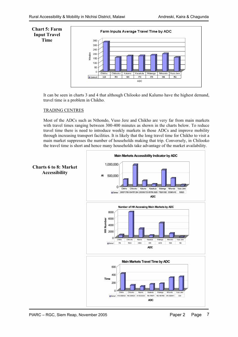
Chart 5: Farm Input Travel
Time
It can be seen in charts 3 and 4 that although Chilooko and Kalumo have the highest demand, travel time is a problem in Chikho.
TRADING CENTRES
Most of the ADCs such as Nthondo, Vuso Jere and Chikho are very far from main markets with travel times ranging between 300-400 minutes as shown in the charts below. To reduce travel time there is need to introduce weekly markets in those ADCs and improve mobility through increasing transport facilities. It is likely that the long travel time for Chikho to visit a main market suppresses the number of households making that trip. Conversely, in Chilooko the travel time is short and hence many households take advantage of the market availability.
Charts 6 to 8: Market Accessibility
0
500,000
1,000,000
AI
ADC
Main Markets Accessibility Indicator by ADC
Series1 296571.789 934787.264 236308.733 85795.3929 715261.382 353961.412 50820
Chikho Chilooko Kalumo Kasakula Malenga Nthondo Vuso Jere
0
2000
4000
6000
8000
HH
Num
ber
ADC
Number of HH Accessing Main Markets by ADC
Series1 718 7833 2593 579 4410 1126 154
Chikho Chilooko Kalumo Kasakula Malenga Nthondo Vuso Jere
0
200
400
600
Time
ADC
Main Markets Travel Time by ADC
Series1 413.052632 119.339623 91.1333333 148.178571 162.190789 314.352941 330
Chikho Chilooko Kalumo Kasakula Malenga Nthondo Vuso Jere

Rural Accessibility & Mobility in Ntchisi District, Malawi Andreski, Kaira & Chagunda
PIARC – RGC, Siem Reap, November 2005 Paper 2 Page 8
#Y
$T$T
$T
$T
$T
$T
$T
$T
$T
$T
$T$T
$T
$T$T$T
$T$T
$T $T$T
$T
$T
$T
$T$T$T$T
$T
$T
$T$T
$T
$T
$T$T
$T
$T$T
$T
$T
$T
$T$T
$T$T
$T
$T$T
$T
$T
$T
$T
$T$T$T
$T
$T
$T
$T
$T
$T
$T$T
$T
$T$T
$T
$T
$T
$T$T
$T$T
$T
$T
$T
$T$T
$T
$T
$T$T
$T
$T$T
$T$T
$T
$T
$T
$T$T
$T
$T
$T
$T$T$T $T
$T
$T$T
$T
$T
$T
$T
$T$T
$T$T
$T
$T
$T$T
$T$T
$T
$T
$T
$T
$T
$T$T$T
$T
$T
$T$T$T
$T
$T
$T
$T
$T
$T
$T
$T
$T
$T$T
$T$T
$T$T
$T
$T
$T
$T$T $T$T $T$T
$T
$T
$T$T
$T
$T $T
$T
$T
$T
$T
$T
$T$T
$T
$T
$T
$T$T$T
$T$T
$T
$T
$T
$T
$T
$T
$T
$T
$T
$T
$T$T
$T
$T
$T
$T
$T
$T
$T
$T
$T
$T
$T
$T
$T
$T
$T
$T
$T$T
$T$T
$T
$T
$T
$T$T
$T
$T
$T$T
$T
$T$T$T
$T$T
$T
$T
$T
$T
$T
$T
$T$T
$T
$T
$T
$T
$T
$T
$T
$T
$T
$T
$T
$T
$T
$T
$T$T
$T
$T$T
$T
$T
$T
$T
$T
$T
$T
$T
$T
$T
$T
$T$T$T$T
$T
$T
$T
$T
$T
$T
$T $T
$T
$T
$T
$T
$T
$T$T
$T
$T
$T
$T$T
$T
$T
$T
$T
$T
$T
$T
$T
$T
$T
$T
$T
$T
$T
$T
$T
$T
$T$T
$T
$T
$T
$T
$T
$T
$T
$T
$T
$T
$T$T
$T $T
$T
$T
$T$T
$T
$T
$T
$T
$T
$T
$T
$T
$T
$T
$T
$T
$T
$T$T
$T
$T
$T$T
$T
$T$T
$T
$T
$T
$T
$T
$T
$T
$T
$T
$T
$T
$T
$T
$T
$T
$T
$T
$T
$T
$T$T
$T
$T$T
$T
$T$T
$T
$T
$T $T
$T
$T
$T
$T
$T
$T
$T
$T
$T
$T
$T
$T
$T
$T
$T
$T
$T
$T
$T
$T
$T
$T
$T
$T
$T
$T$T
$T$T
$T
$T
$T
$T
$T
$T
$T
$T$T
$T$T
$T
$T
$T
$T
$T
$T
$T
$T
$T
$T
$T
$T
$T$T
$T
$T
$T $T
$T
$T$T
$T
$T
$T
$T
$T
$T
$T
$T
$T
$T$T
$T$T$T
$T
$T
$T
$T
$T $T$T
$T $T
$T
$T
$T$T
$T$T
$T
$T
$T
$T
$T
$T
$T
$T$T
$T
$T
$T
$T
$T
$T
$T
$T
$T
$T$T
$T
$T$T
$T
$T
$T
$T
$T
$T
$T
$T
$T$T
$T
$T$T$T
$T
$T
$T
$T
$T
$T
$T
$T
$T
$T
$T
$T
$T
$T
$T
$T
$T $T
$T
$T
$T
$T$T$T
$T
$T
$T
$T
$T
$T
$T
$T
$T$T
$T
$T
$T
$T
$T
$T$T
$T
$T
$T
$T
$T
$T
$T
$T
$T
$T
$T
$T
$T
$T
$T
$T
$T
$T
$T
$T
$T
$T
$T
$T
$T
$T
$T
%U
%U%U
%U
%U
%U %U
%U%U
%U
%U
%U
%U
%U
%U
%U%U
%U %U
%U
%U
%U
%U
C h i l o o k o
M a l e n g a
K a l u m o
V u s o J e r e
C h i k h o
K a s a k u l a
N t h o n d o
B o m a
C h i n t h e m b w e
C h i m b i n d u
K a n s o n g a
N y a l a b v i
K a n t h u n g o
C h i b i n y a
K a n g o l i w a
C h i b i s a
C h i l o o k o
N g 'o m b eM a l i k e t i
K a s a k u l a
K a n g o l w a
L i w o n d e
C h i m b w e y a
C h i n k h a n d w e
C h i k h oK h u w i
M p a l o
K a l u m o
5 8 0 0 0 0
5 8 0 0 0 0
6 0 0 0 0 0
6 0 0 0 0 0
6 2 0 0 0 0
6 2 0 0 0 0
8520
000 8520000
8540
000 8540000
8560
000 8560000
N t c h i s i D i s t r i c t - L o c a t i o n o f T r a d i n g C e n t r e s
4 0 4 8 K i l o m e t e r s
S c a l e 1 : 6 0 0 , 0 0 0
N
C o n t o u r l i n e s
M i n o r
M a jo rV i l l a g e s$T
B o m a#Y
D i s t r i c t B o u n d a r y
T A B o u n d a r ie sN t c h i s i D i s t r i c t A s s e m b l y
R A M P A P r o j e c t
D a t e : 2 1 S e p t e m b e r 2 0 0 5 / S o u r c e : A r c V i e w 3 . 3 , A r c G I S 8 . 1 / S c a le : 1 : 6 0 0 , 0 0 0 / P r o j e c t i o n : U T M Z o n e 3 6 / P r e p a r e d b y : C o s t l y C h a n z a
L e g e n d
T r a d i n g C e n t r e s%U
M a i n R o a d
D i s t r i c t R o a d
S e c o n d a r y R o a d
T e r t i a r y R o a d
O t h e r R o a d s
V i e w 1
9 . 0
A detailed topographic map showing the location of the main trading centres is given in Map 3 below:
Map 3: Topographical Map of Ntchisi District Showing Main Roads, Trading Centres and Villages

Rural Accessibility & Mobility in Ntchisi District, Malawi Andreski, Kaira & Chagunda
PIARC – RGC, Siem Reap, November 2005 Paper 2 Page 9
#Y %U
%U%U
%U
%U
%U %U
%U%U
%U
%U
%U
%U
%U
%U
%U%U
%U %U
%U
%U
%U
%U
Chilooko
Malenga
Kalum o
Vuso Jere
Chikho
Kasaku la
Nthondo
Boma
Chinthembwe
Chimbindu
Kansonga
Nyalabvi
Kanthungo
Chib inya
Kangol iwa
Chib isa
Chilooko
Ng'ombeMaliketi
Kasakula
Kangolwa
Liwonde
Chimbw eya
Chinkhandwe
ChikhoKhuwi
Mpalo
Kalumo
4 0 4 8 Kilo meter s
Sc ale1 :600,000
N
View1
#Y
$T$T
$T
$T
$T
$T
$T
$T
$T
$T
$T$T
$T
$T$T$T
$T$T
$T$T$T
$T
$T
$T
$T$T$T$T
$T
$T
$T$T
$T
$T
$T$T
$T
$T$T
$T
$T
$T
$T$T
$T$T
$T
$T$T
$T
$T
$T
$T
$T$T$T
$T
$T
$T
$T
$T
$T
$T$T
$T
$T$T
$T
$T
$T
$T$T
$T$T
$T
$T
$T
$T$T
$T
$T
$T$T
$T
$T$T
$T$T
$T
$T
$T
$T$T
$T
$T
$T
$T$T$T $T
$T
$T$T
$T
$T
$T
$T
$T$T
$T$T
$T
$T
$T$T
$T$T
$T
$T
$T
$T
$T
$T$T$T
$T
$T
$T$T$T
$T
$T
$T
$T
$T
$T
$T
$T
$T
$T$T
$T$T
$T$T
$T
$T
$T
$T$T $T$T $T$T
$T
$T
$T$T
$T
$T $T
$T
$T
$T
$T
$T
$T$T
$T
$T
$T
$T$T$T
$T$T
$T
$T
$T
$T
$T
$T
$T
$T
$T
$T
$T$T
$T
$T
$T
$T
$T
$T
$T
$T
$T
$T
$T
$T
$T
$T
$T
$T
$T$T
$T$T
$T
$T
$T
$T$T
$T
$T
$T$T
$T
$T$T$T
$T$T
$T
$T
$T
$T
$T
$T
$T$T
$T
$T
$T
$T
$T
$T
$T
$T
$T
$T
$T
$T
$T
$T
$T$T
$T
$T$T
$T
$T
$T
$T
$T
$T
$T
$T
$T
$T
$T
$T$T$T$T
$T
$T
$T
$T
$T
$T
$T $T
$T
$T
$T
$T
$T
$T$T
$T
$T
$T
$T$T
$T
$T
$T
$T
$T
$T
$T
$T
$T
$T
$T
$T
$T
$T
$T
$T
$T
$T$T
$T
$T
$T
$T
$T
$T
$T
$T
$T
$T
$T$T
$T $T
$T
$T
$T$T
$T
$T
$T
$T
$T
$T
$T
$T
$T
$T
$T
$T
$T
$T$T
$T
$T
$T$T
$T
$T$T
$T
$T
$T
$T
$T
$T
$T
$T
$T
$T
$T
$T
$T
$T
$T
$T
$T
$T
$T
$T$T
$T
$T$T
$T
$T$T
$T
$T
$T $T
$T
$T
$T
$T
$T
$T
$T
$T
$T
$T
$T
$T
$T
$T
$T
$T
$T
$T
$T
$T
$T
$T
$T
$T
$T
$T$T
$T$T
$T
$T
$T
$T
$T
$T
$T
$T$T
$T$T
$T
$T
$T
$T
$T
$T
$T
$T
$T
$T
$T
$T
$T$T
$T
$T
$T $T
$T
$T$T
$T
$T
$T
$T
$T
$T
$T
$T
$T
$T$T
$T$T$T
$T
$T
$T
$T
$T $T$T
$T $T
$T
$T
$T$T
$T$T
$T
$T
$T
$T
$T
$T
$T
$T$T
$T
$T
$T
$T
$T
$T
$T
$T
$T
$T$T
$T
$T$T
$T
$T
$T
$T
$T
$T
$T
$T
$T$T
$T
$T$T$T
$T
$T
$T
$T
$T
$T
$T
$T
$T
$T
$T
$T
$T
$T
$T
$T
$T $T
$T
$T
$T
$T$T$T
$T
$T
$T
$T
$T
$T
$T
$T
$T$T
$T
$T
$T
$T
$T
$T$T
$T
$T
$T
$T
$T
$T
$T
$T
$T
$T
$T
$T
$T
$T
$T
$T
$T
$T
$T
$T
$T
$T
$T
$T
$T
$T
$T
%U
%U%U
%U
%U
%U %U
%U%U
%U
%U
%U
%U
%U
%U
%U%U
%U %U
%U
%U
%U
%U
Chilooko
Malenga
Kalum o
Vuso Jere
Chikho
Kasakula
Nthondo
Boma
Chin thembwe
Chimbindu
Kansonga
Nyalabvi
Kanthungo
Chibinya
Kango l iwa
Chib isa
Chilooko
Ng'ombeMaliketi
Kasaku la
Kangolwa
Liwonde
Chimbw eya
Chinkhandwe
ChikhoKhuwi
Mpalo
Kalumo
4 0 4 8 Kilo m eter s
Sc ale1:600,000
N
View1
Map 4 below shows that some of these markets are not linked by a secondary or main road. Map 5 below shows the location of villages in relation to these markets.
Map 4: Main Roads and Markets
Map 5: Villages and Markets

Rural Accessibility & Mobility in Ntchisi District, Malawi Andreski, Kaira & Chagunda
PIARC – RGC, Siem Reap, November 2005 Paper 2 Page 10
Map 8 shows villages with a health AI of greater than 5,000. Chilooko ADC has already been identified as having a problem from the bar charts. From this chart building a health centre in the north of Chilooko, improving access west of Chikwakwa and Kasonga health centres, and improving access north of Kangolwa health centre in Kasakula ADC would be well justified.
$
$$
$
$
$
$
$
$
$$
$
$
$
$
$
$$
$ $
$
$
$$
$
$
$
$
$
$
$
$
$
$
$$
$$
$
$
$
$
Ý
Ý
Ý
Ý
Ý
Ý
Ý
ÝÝ Ý
Ý
#Y
Chilooko
Malenga
Kalumo
Vuso Jere
Chikho
Kasakula
Nthondo
Nthondo Mndinda
Mkhuzi Mpherere
Chinthembwe
Kangolwa
Mzandu
Chikwakwa
Boma
District H os pital
Kansonga
Khuwi
4 0 4 8 KilometersSc ale1:600,000
N
Map 8: Villages with Health AI>5,000

Rural Accessibility & Mobility in Ntchisi District, Malawi Andreski, Kaira & Chagunda
PIARC – RGC, Siem Reap, November 2005 Paper 2 Page 11
ÊÚ ÊÚ
ÊÚÊÚ
ÊÚ
ÊÚ
ÊÚÊÚ
ÊÚ
ÊÚ
ÊÚ
ÊÚÊÚ
ÊÚ
ÊÚ
ÊÚ
ÊÚÊÚÊÚ
ÊÚ
ÊÚÊÚ
ÊÚ
ÊÚ
ÊÚÊÚ
ÊÚ
ÊÚÊÚ
ÊÚ
ÊÚÊÚ
ÊÚÊÚ
ÊÚ
ÊÚ
ÊÚÊÚ
ÊÚÊÚ
ÊÚ
ÊÚ
ÊÚ
ÊÚÊÚ
ÊÚ
ÊÚ
ÊÚ
ÊÚÊÚÊÚ
Ý
Ý
Ý
Ý
Ý
Ý
Ý
ÝÝ Ý
#Y
Chilooko
Malenga
Kalumo
Vuso Jere
Chikho
Kasakula
Nthondo
Nthondo Mndinda
Mkhuzi Mpherere
Chinthembwe
Kangolwa
Mzandu
Chikwakwa
Boma
Kansonga
Khuwi
4 0 4 8 Kilometer sSc ale1:600,000
N
It is interesting to note that there are more traditional healers in Ntchisi than health centres as illustrated in map 9. The role of such people should not be dismissed since they provide a affordable services that the Government authorities cannot provide. However, these “Healers” also offer a number of other services such as identifying thieves and helping people to become promoted.
TRANSPORT
Ntchisi District is linked to other districts through a network of roads. There are five classes of roads in the district, namely, main, secondary, tertiary, district, and undesignated roads. The district has a road network of 877km. Most of these are earth roads, which are in poor condition but still passable throughout the year. Within this road network are 51 bridges, 608 culverts and 31 drifts. Charts 12 to 14 below show that the time householders take to reach transport services can be nearly two hours in Chikho area. The high AI in Chilooko area shows a high demand for services and that is related to its relatively high population.
Map 9: Location of Traditional Healers

Rural Accessibility & Mobility in Ntchisi District, Malawi Andreski, Kaira & Chagunda
PIARC – RGC, Siem Reap, November 2005 Paper 2 Page 12
Charts 12 to 14 Transport Service
Accessibility
The World Bank is promoting the target of accessibility of all to within 2km of an all weather road. The GIS has been queried to identify villages that are more than 2km from a classified road. These villages are shown red dots in Map 10 opposite. Unfortunately,not all classified roads are all weather in Malawi, but that should also be a long term target and the power of GIS is illustrated.
##
#
#
#
#
#
#
#
#
##
#
###
##
###
#
#
#
####
#
#
##
#
#
##
#
##
#
#
#
##
##
#
##
#
#
#
#
###
#
#
#
#
#
#
##
#
##
#
#
#
##
##
#
#
#
##
#
#
##
#
##
##
#
#
#
##
#
#
#
### #
#
##
#
#
#
#
##
##
#
#
#
###
#
#
#
#
#
###
#
#
###
#
#
#
#
#
#
#
#
#
##
##
##
#
#
#
## ## ##
#
#
##
#
# #
#
#
#
#
#
##
#
#
#
###
##
#
#
#
#
#
#
#
#
#
#
##
#
#
#
#
#
#
#
#
#
#
#
#
#
#
#
#
##
##
#
#
#
##
#
#
##
#
###
##
#
#
#
#
#
#
##
#
#
#
#
#
#
#
#
#
#
#
#
#
#
##
#
##
#
#
#
#
#
#
#
#
#
#
#
####
#
#
#
#
#
#
# #
#
#
#
#
#
##
#
#
#
##
#
#
#
#
#
#
#
#
#
#
#
#
#
#
#
#
#
##
#
#
#
#
#
#
#
#
#
#
##
# #
#
#
##
#
#
#
#
#
#
#
#
#
#
#
#
#
##
#
#
##
#
##
#
#
#
#
#
#
#
#
#
#
#
#
#
#
#
#
#
#
#
##
#
##
#
##
#
#
# #
#
#
#
#
#
#
#
#
#
#
#
#
#
#
#
#
#
#
#
#
#
#
#
#
#
##
##
#
#
#
#
#
#
#
##
##
#
#
#
#
#
#
#
#
#
#
#
#
# #
#
#
# #
#
##
#
#
#
#
#
#
#
#
#
##
###
#
#
#
#
# ##
# #
#
#
##
##
#
#
#
#
#
#
#
##
#
#
#
#
#
#
#
#
#
##
#
##
#
#
#
#
#
#
#
#
##
#
###
#
#
#
#
#
#
#
#
#
#
#
#
#
#
#
#
# #
#
#
#
###
#
#
#
#
#
#
#
#
##
#
#
#
#
#
##
#
#
#
#
#
#
#
#
#
#
#
#
#
#
#
#
#
#
#
#
#
#
#
#
#
#
#
Chilooko
Malenga
Kalumo
Vuso Jere
Chikho
Kasakula
Nthondo
Chidziko
Ngopi II
Kayoyo
Kawam ba
Za mb ala
Mchere/Mo to
Th en doChika dewa
Chabz ala
Mn gopi II
Mtaw ira
Md akulen ga
Khond owe
Mn dindaMd in da
Mn gopi I
Kayera
Chapa ula
Mg opi IIChiond oMb ulum a
Msa ka ch alo
Sanin ga
Chbzyala
Chipomph a
Nya nja IChagu nda
Ntchisi Bo ma
Kapon da
Chikw asa
Chand awiraChaga lawan da
ChibwenjeMa sankhula
Mwa lumo
Ma sacheChikh o II
Ban ja
Nkh untho
Ma ta koMn kh ang'a
Chom be Jeredi
Mzo ma
Ma yem be
Chatire
Chikh o
Mn th ewe IMtsekamph
Mu nika
Kachipap a
Kapatu ka
Bowa
Chabin yaChifwelek
Chikw akw a
Chimb iya
Chimb ulan
Ching'amb
Chipacha
Chipon da
Chithund uDzim we
Gam ba
Kabenu
Kalupsa
Kamphikul
Kanda le M
Kanyere I
Kapulu la
Kasiya
Katang alaLend o
Ma fu ta
Ma ta mu la
Mb iya
Mchere Mo to
Mp henyeng
Msh am boza
Nandeta
Kando do
Ngolomi
Chigwe
Chiku numb
ChithonjeChiunjizaKacheren ga
Kakonkhwe
Kapichira
Katapa (K
Kazionets
Kazon gaMa ta pa (C
Mg olo
Mn dambo I
Ntcha ch e
Kanchocho
Chapu ch ap
Chiku sa
Kapim phi
Khwamba
Mfwitizal
Mp hombwe
Simo n
Ma la mb ilo II
Chentch eMvula
Ma nong 'oMa leng a IIMb uluma
Mjim aSolomoni
Tchite
Mching aleza
Za mb a
Ma ta nda
Zu nga
Chidatha
Chidzalo
Chitawo T
Gwenembe
Kafanikha
Kando do
Kanyam a
Katantha
Mb ulawo
Mikwala IMkazind in
Mza ndu I
Ndoli
Ngwewa
Ntcheto
Nyem be
Bumph ula
Chankha la
Chapin gam
Chifisa IChifisa I
Chikh o
Chiku ta
Chikw awe
ChilookoChilooko
Chima imb a
Chimb alan
Chimb iri
Chimkwend
Chimp hon d
Chimu nthu
Chimw ala
Chingluw e
Ching'omb
Chioza
Chipendek
Chipinjik
ChipolokaChipolop o
Chitambwe
Chithyola
Chiweza
Chizewe
Chizula
Cholamaka
Chombe
Choveka
Chung u
Dete
Gom e
Gum ba
Gweluka
Head Quar
Kachere I
Kachingu n
Kadza mira
Kadzeya
Kadzidzi
Kalilangw
Kalindama
Kam amchen
Kanda le
Kang'ombe
Kanyra M a
Kanyulun y
Kapala
Kapan gam a
Kapha tikaKaphiri
Kaphu ka
Kasinja
Kater a
Kavulala
Kavwen je
Kazon golo
Khuwi
Kwen dakwi
Lu kwa , Mz
Lu mb eMa la mb o
Ma lo moMa lo mo A r
Ma lu za
Ma nkhaka
Ma nkhudzu
Ma nthalu
Ma sanya
Ma tid zaMa tu kwa no
Mb ewa
Mb obo
Mb om ba I
Mizo ndo
Mkan ileMkom be
Mkon kha
Mkwech e
Mn desi
Mn dimb aMn duka
Mn ja le
Mp ofu
Msu kuMtseche
Mwin ama
Nduwa
Nelesoni
Ngom a
Nja kw a
Njo we
Sankha niTimoti Za mb aler o
Biwi Chazim 'bo
Kachulu
Kalima mkuKambwemb w
Kayed zeka
Mb ondo ma
Mp am ira
Ngo'm be
Nkh adan i
Th und uzi
Bzyobzyo
Chalum ako
Cham phu la
Chaun ga
Chibisa
Chima tir o
Chipon do
Chisala
Chisong a
Chiziko
Gaw en i
Gideon
Gula
Kankowe
Kanyerere
Ma were I
Ma were II
Mithi
Mn g'on ga
Mo to
Nduwa I
Nkh ako
Nkwichi
Nsankhire
Ntchere
Nya nja II
Shad reck
Tso ko nom b
Und i
ChaolaChawa la
Chidambo
Chimw ala
Chisamba
Chiwaula
Ndund u
Nth ukwa
Nya nga
Sofasi
Vuso Jere
Binga mvulBwan am ali Chaseta
Chimb alu
Chimb wand
Chiopya ChipolwaChulu I
Efelemu
Gomezani
Gwilan g'o
Jab es i
Jere
Kalong a
Kam gom a
Kamsonga
Kanthu ngo
Katen je IKatimb a
Kazon ga
Lo ngwe
Ma la itcha
Ma la ngo I
Mb ototoMb ulum a
Md ambo I
Mfwiri
Mkumbula
Mp hambaMsa gadi
Mteya
Mteya K an
Mtha ila
Mtuta
Mwa nsan ga
Mweso
Nikisi
Nkh alam o
Nkh alapa t
Saulo si
Simwa za
Ta ndwe
Za ma ngwe
Ban dawe
Binga mvul
Chabu ka
Chabw in kh
Chana ngaChand awil
Chibisa
Chidzaye
Chikh ugwa
Chikh utu
Chikh wakh
Chiku wi
Chilasa I
Chimb akaChimw ala
Chingu wo
Chipeni
Chipoloka
Chisoso
Chitete
Chiwaliwa
Chorwe
Chulu II
Jenula
Kachilam n
Kadan go
Kafwafwa
Kalowan g'
Kalumo
Kanyenda
Katsika
Kawenda I
Khofi
Khuwi
Ma ka nda
Ma la ma
Ma leng am k
Ma ndoMa vwa nje
Mb en de
Mcheteche
Ming u
Mkab asi
Mkhu zi
Mn jin gi
Mp haleMp hasa
Mp otacham
Mwa lala I
Mzu ma zi
Ng'an ga
Ng'ombe T
Nya la bvu
Petro Bwa
Reuben so
Sajeni S a
Saom ba nje
Sibawo
Tcha le
Th en geza
Tsa bvu
Tso nga
Visambo
Mg owo
4 0 4 8 Kilo meter s
Sc ale1:600,000
N
Map 10: Villages Coloured Red Further than 2km from a Classified Road

Rural Accessibility & Mobility in Ntchisi District, Malawi Andreski, Kaira & Chagunda
PIARC – RGC, Siem Reap, November 2005 Paper 2 Page 13
WATER
The GIS has also been queried to identify villages that are more than 300m from a borehole, well, river or spring. These are shown as red dots in Map 11 and clearly a water project starting up in the district should pay attention to these red villages, such as those circled below.
3.4 Updating Socio-economic Profile of District
Much of the information above has been fed into a document entitled the “Socio-Economic Profile” of the District, and the RAMPA project has been instrumental in preparing the most comprehensive one in the District. Unfortunately, funds available from internal sources to solve the problems identified by the project are limited (~US$50,000 p.a.) as shown in the following charts and tables. (MK125=US$1)
##
#
#
#
#
#
#
#
#
##
#
#
##
##
##
#
#
#
#
###
##
#
#
#
#
#
#
#
#
#
#
#
#
#
##
##
#
#
#
#
#
#
#
##
#
#
#
#
#
#
#
##
#
##
#
#
#
#
#
#
#
#
#
#
##
#
#
#
#
#
##
#
#
#
#
#
##
#
#
#
##
##
#
##
#
#
#
#
##
#
#
#
#
#
##
#
#
#
#
#
#
##
#
#
#
##
#
#
#
#
#
#
#
#
#
##
##
##
#
#
#
## ## ##
#
#
##
#
# #
#
#
#
#
#
#
#
#
#
#
#
##
##
#
#
#
#
#
#
#
#
#
#
##
#
#
#
#
#
#
#
#
#
#
#
#
#
#
#
#
#
#
#
##
#
#
#
#
##
##
#
#
#
#
#
#
#
#
#
#
#
#
#
#
#
#
#
#
#
#
#
#
#
##
#
#
#
#
#
#
#
#
#
#
#
####
#
#
#
#
#
# #
#
#
#
#
#
##
#
#
#
##
#
#
#
#
#
#
#
#
#
#
#
#
#
#
##
#
#
#
#
#
#
#
#
#
##
# #
#
#
#
#
#
#
#
#
#
#
#
#
#
#
#
#
#
##
#
#
#
#
#
#
#
#
#
#
#
#
#
#
#
#
#
#
#
#
#
#
#
#
#
#
#
#
#
#
#
#
##
#
#
##
#
#
#
#
#
#
#
#
#
#
#
#
#
#
#
#
#
#
#
#
#
#
#
#
#
##
##
#
#
#
#
#
#
#
##
##
#
#
#
#
#
#
#
#
#
#
#
##
#
#
#
##
##
#
#
#
#
#
###
#
#
#
#
# #
## #
##
#
#
#
#
#
#
#
#
#
#
#
#
#
#
#
#
#
#
#
#
##
#
#
#
#
#
#
#
#
##
#
###
#
#
#
#
#
#
#
#
#
#
#
#
#
#
#
#
# #
#
#
#
###
#
#
#
#
#
#
#
#
##
#
#
#
#
#
##
#
#
#
#
#
#
#
#
#
#
#
#
#
#
#
#
#
#
#
#
#
#
#
#
#
#
#
#Y
Chilooko
alenga
Kalumo
Vuso Jere
Chikho
Kasakula
Nthondo
Boma
Mphe l el e
Dwanzi
Nkhula
Kaml enje
Mphele le
Z in do
C himbwazi
Ch afumb i
Chafumbi
K aombe
Nd a wu
Mbwetwe
Nk ula
Kala
Na chiwa li
Lifu liza
Chipa
2 0 2 4 Kilo me te rs
Scale 1:60 0,00 0
N
Map 11: Villages Coloured Red that are More Than 300m from Water Supply

Rural Accessibility & Mobility in Ntchisi District, Malawi Andreski, Kaira & Chagunda
PIARC – RGC, Siem Reap, November 2005 Paper 2 Page 14
Chart 15: District Revenue
Allocations to the District from Central Government over the last two years are low but more than doubled over the two years as shown in the table below.
Month 2003 / 2004 2004 / 2005 Total 1,872,261.00 4,521,415.00
Nevertheless, there are a number of NGOs working in the District such as:
(i) Public Affairs Committee-National Initiative for Civic Education (PAC-NICE); (ii) World Vision International (WVI); (iii) Malawi Red Cross Society; (iv) National Smallholder Farmers Association of Malawi (NASFAM); (v) CARE;(vi) Circle for Integrated Community Development (CICOD); (vii) Target National Relief and Development (TANARD); (viii) Civil Rights Advocacy Centre (CRAC); and (ix) Civil Liberties Committee (CILIC).
Development Partners operating in the district include: European Union, DFID, World Bank, African Development Bank, UNDP, UNICEF and WHO. All of these organisations are now in a position to better target their interventions due to the establishment of the IRAP and GIS databases by the RAMPA project.
The sums provided by these various partners greatly exceed the direct government allocations. Consequently, it should be made known to all of them the planning facilities now available.
0.00
200,000.00
400,000.00
600,000.00
800,000.00
1,000,000.00
1,200,000.00
1,400,000.00A
mou
nt c
olle
cted
Revenue Source by year
District Revenue Base
2002/2003 469,670.00 356,640.00 203,935.00 155,600.00 410,970.12 28,450.00 1,200.00 0 0
2003/2004 0 199,730.00 166,633.00 105,910.00 914,839.00 25,650.00 2,700.00 0 65,750.00
2004/2005 1,231,455. 324,048.00 473,405.00 189,428.00 859,892.00 67,400.00 250.00 160,000.00 61,000.00
Market fees
Resthouse fees
Business premises licence
Rental fees
Commercial
undertakin
Registration fees
Liquor Licence
Rent Income
Conferenc
Miscellaneous Sale of Document

Rural Accessibility & Mobility in Ntchisi District, Malawi Andreski, Kaira & Chagunda
PIARC – RGC, Siem Reap, November 2005 Paper 2 Page 15
3.5 Updating District Development Plan
One of the main uses of this information is to update the District Development Plan and the latest version for the 3-year period 2006-2008 will be available in December 2005. As part of the preparation for the new Plan, a review was carried out of progress made over the period 2003 to 2005 on all the various sectors in the District and an example for Roads and Fisheries is given in Table 3 following page. Heads of department of the all the District Council sections such as Works, Education, Police and Water assembled in September and October 2005 to consider the plan, identify needs for services, this time taking into account the IRAP information.
4. Improvement in Mobility
The RAMPA project also looked at how to improve mobility within the District. This focussed on providing Intermediate Modes of Transport (IMT). The IRAP survey indicated that walking and head-loading is the most dominant form of transport and hence IMTs could ease this burden.
The survey data given in the table below indicates that the district has IMTs in the form of bicycles, oxen, donkeys, oxcarts, and wheelbarrows, bicycle trailers and ambulances. The predominant IMT is the bicycle. The bicycle and oxcarts are mostly operational in flat and rolling terrains of Kalumo, Malenga and part of Chiloko and there are markedly less operational in the hilly and mountainous terrains of Nthondo, Chikho, Vuso Jere, and Kasakula. The Wheelbarrow is mostly used for construction purposes.
With regard to gender access to the available Intermediate Means of Transport, the databank reveals that women own less of the IMTs and have limited access to the available means of transport. Yet, they share the greatest burden of domestic activities and assist males in field activities in addition to domestic chores. The male farm work is usually four months of the year (November – February). The women take over harvest jobs and other post harvest chores. Their most common mode of travel and transport is walking and head-loading. As such, women bear the greatest burden of rural travel and transport burden in the district.
Table 2: Ownership of IMTs in Ntchisi District Type of IMT TA Owner-
ship1
OxenDonkey Animal
Cart Handcart W/barrow Bicycle Bicycle
TrailerMHH 3 0 1 5 4 133 3
Chikho FHH 0 0 0 0 1 1 0 MHH 28 8 60 0 11 888 0 Chilooko FHH 1 0 3 0 0 9 0 MHH 68 4 104 0 17 356 1 Kalumo FHH 2 0 4 0 2 3 0 MHH 8 3 3 0 6 189 1 Kasakula FHH 0 0 0 0 0 22 2 MHH 28 2 48 15 11 296 10
Malenga FHH 0 0 0 1 0 1 0 MHH 2 0 8 0 2 165 0 Nthondo FHH 0 0 2 0 2 0 0 MHH 11 0 8 0 23 89 0 Vuso Jere FHH 0 1 0 0 4 2 0 MHH 148 17 232 20 74 2,116 15 Total FHH 3 1 9 1 9 38 2
MHH= Male headed households; FHH= Female headed household

Rur
al A
cces
sibi
lity
& M
obili
ty in
Ntc
hisi
Dis
trict
, Mal
awi
And
resk
i, K
aira
& C
hagu
nda
PIA
RC
– R
GC
, Sie
m R
eap,
Nov
embe
r 200
5 P
aper
2P
age
16
Sect
or
Dev
elop
men
t O
bjec
tive
Prog
ram
me
Targ
et
Plan
ned
Ach
ieve
men
t Fa
ilure
R
emar
ks
Com
men
ts
Roa
ds
To im
prov
e th
e liv
ing
stan
dard
s of
peo
ple
thro
ugh
enha
nced
and
eq
uita
ble
Roa
d ne
twor
k di
strib
utio
n to
ac
cess
Soc
io-
econ
omic
s fa
cilit
ies.
2002
1.1
HIP
IC g
radi
ng
1.2
Rel
ief c
ash
for
wor
k (L
abou
r in
tens
ive)
1.3a
R
oads
re
habi
litat
ions
1.3b
B
ridge
re
habi
litat
ions
1.4
Gra
vel b
ase
reco
nstru
ctio
n an
d cu
lver
ts in
stal
latio
n
(449
.2K
m)
201.
6Km
180K
m
40.9
m (2
0 N
o.)
5.6K
m
359K
m
38K
m
135.
4Km
180K
m
40.9
m (5
No.
)
5.6K
m
90.2
Km
163K
m
To p
rovi
de
stru
ctur
alcr
ossi
ngs o
n im
prov
ed
earth
wor
ks
Inad
equa
te
fund
ing
Polic
y re
stric
tions
Con
tract
ual
syst
em
Con
tract
ual
syst
em
Nat
iona
l Roa
ds A
utho
rity
(NR
A)
Mal
awi S
ocia
l Act
ion
Fund
(MA
SAF)
Gov
ernm
ent,
EU P
ublic
W
orks
Pro
gram
me
Gov
ernm
ent,
EU P
ublic
W
orks
Pro
gram
me
MA
SAF,
WV
I , N
RA
Fish
erie
s To
ens
ure
that
80
% o
f far
m
fam
ilies
are
food
se
cure
d by
200
5
1.1
DD
P fis
h fa
rmin
g 30
0 Po
nds
106
Pond
In
adeq
uate
reso
urce
s to
reac
h 34
4 Po
nds.
1.2
Fish
reso
urce
s m
anag
emen
t FF
-80%
FF
-20%
FF
-60%
The
reso
urce
s wer
e no
t ad
equa
te to
reac
h 80
%
1.3
EU m
ulti
annu
al
food
secu
rity
18
9 Po
nds
9 Po
nds
1.4
Fish
erie
s (H
IPIC
) 32
78
Pon
ds
1.5
Wor
ld v
isio
n
40
19 P
onds
21
T
able
3: R
oad
and
Fish
erie
s Sec
tor
Dev
elop
men
t Pla
n T
arge
ts a
nd A
chie
vem
ents
200
3 - 2
005

Rural Accessibility & Mobility in Ntchisi District, Malawi Andreski, Kaira & Chagunda
PIARC – RGC, Siem Reap, November 2005 Paper 2 Page 17
Under the project, four artisans have had two weeks training at Rumphi Polytechnic in making axles and wheels for animal carts. Thirty axles and wheels have been made and after delivery the artisans built the carts. Also, 32 donkeys have been purchased in Mozambique and are under quarantine until blood sample results come from South Africa. Delivery will take place as soon as the import licence requirements for Government of Malawi are met. Regarding credit, a Memorandum of Understanding has been signed between Malawi Rural Finance Company and Malawi Rural Transport & Travel Project/Ntchisi District Assembly for the administration of the credit. Groups have already been identified from the 7 ADCs; and will be handed over to MRFC for screening for the loans.
5. Improvement in Access
Another element of the programme looked at improving accessibility. Training of Small Scale Community Contractors was completed with the construction of 1 km of earth road labour-based standard in the 7 ADCs with structures such as culverts and drifts including one wooden deck bridge. The graduation was 1 July 2005 and this was followed by award of trial maintenance contracts at the end of August 2005 to the seven newly formed construction companies by the trainees. During the graduation, the National Construction Council Directors Technical and Training were part of the Team that inspected the works and they were quite impressed and advised the trainees to seek registration with them.
A total of 37 km were maintained under the trial contracts and all were completed well with minimum supervision. This exercise demonstrated that labour based road maintenance can be managed at district level rather than through central programmes.
6. Conclusions
The RAMPA project has been highly successful in incorporating the planning tools IRAP and GIS into the District planning cycle. Further analysis is still required following the integration of the IRAP database into the GIS. This would then enable us to pick out villages with a particular AI and then group them in a certain area for project design purposes for the other sectors not covered in this paper.
Since Ntchisi District now has the most comprehensive data and planning tool available in Malawi, the Government and its Development Partners should take advantage of this to develop well target projects in the District. A new paved road linking the District with the rest of the paved road network is now under construction. Consequently, there is every opportunity to prepare and implement a model integrated infrastructure development plan in Ntchisi District.
The cost of the RAMPA project was $700,000 including consultancy, IRAP and GIS surveys, collection of secondary data, preparation of Socio-Economic Profile and District Development Plan, contractor training/trial contracts and IMT promotion. However, this was a pilot and it is estimated that a rollout to the remaining 25 districts in the country would cost around $250,000 per district. This information is valid for at least five years and hence around $50,000 per year would be spent on planning.
Malawi receives around $500 million per year in development aid (OECD statistics). If half of it goes to district development then each district would receive around $10m/year each. This means that around 0.5% of aid would be spent on an efficient planning system and consequently it is recommended that this pilot now be rolled out country wide.

Rural Accessibility & Mobility in Ntchisi District, Malawi Andreski, Kaira & Chagunda
PIARC – RGC, Siem Reap, November 2005 Paper 2 Page 18
ANNEX 1: ROAD MAP OF MALAWI
Namitete
Salima
Chipoka
Mozambique
LILONGWEDEDZA
Tsangano
Lake Malawi
LILONGWE
Lobi
Nathenje
DedzaGolomoti
Ntcheu
Jenda
Lake Malawi
MZIMBA
Karonga
Rumphi
Mzuzu
ZAMBIA
TANZANIA
Lake Malawi
Nkhata Bay
Chintheche
Chilumba
RUMPHI
NKHATA BAY
Chitipa
Kafukule
Usisya
Mzimba
Edingeni
MZIMBA
Euthini
Chisenga
EkwendeniChikwina
Nkhotakota
Mtanga
Ntchisi
MkhotaDowa
ZAMBIA
NKHOTAKOTA
Mponela
Nthunga
KASUNGU
NTCHISI
DOWA
MCHINJI
Mchinji
Kasungu
Liwonde
Ntaja
Zomba
Namadzi
Phalombe
Milange
Mulanje
Nambazo
Mozambique
Lake Chilwa
MACHINGA
Machinga
ZOMBA
MULANJE
Monkey Bay
Mangochi
Makanjila
Mandimba
MozambiqueLake Malombe
MANGOCHI
Balaka
Lake Chiuta
Neno
ChiradzuluBlantyre Limbe
Thyolo
N’gabu
Bangula
Chikwawa
Nsanje
Mwanza
MWANZA BLANTYRE
THYOLO
NSANJE
CHIKWAWA
Luchenza
CHITIPA
KARONGA
SALIMA
Senga Bay
NTCHEU
Thekerani
KeyMain Roads
Secondary Roads
District BoundaryInternational DISTRICT NAME
Tertiary Roads