Rule 609 Statewide Groundwater Baseline Sampling and ... · 609. STATEWIDE GROUNDWATER BASELINE...
51
Rule 609 Statewide Groundwater Baseline Sampling and Monitoring Arthur W. Koepsell, P.G.
Transcript of Rule 609 Statewide Groundwater Baseline Sampling and ... · 609. STATEWIDE GROUNDWATER BASELINE...

Rule 609 Statewide Groundwater Baseline
Sampling and Monitoring
Arthur W. Koepsell, P.G.

609. STATEWIDE GROUNDWATER BASELINE SAMPLING AND MONITORING:
Rule 609 applies to Oil and Gas Wells, Multi-Well Sites, and Dedicated Injection Wells as defined in the 100- Series Rules, for which a Form 2 Application for Permit to Drill is submitted on or after May 1, 2013. Rule 609 does not apply to an existing Oil or Gas Well that is re-permitted for use as a Dedicated Injection Well. This rule does not apply to Oil and Gas Wells, Multi-Well Sites, or Dedicated Injection Wells that are regulated under Rule 608.b. or Rule 318A.e.(4).

100 Series Definitions WATER SOURCE shall mean water wells that are registered with Colorado Division of Water Resources, including household, domestic, livestock, irrigation, municipal/public, and commercial wells, permitted or adjudicated springs, or monitoring wells installed for the purpose of complying with groundwater baseline sampling and monitoring requirements under Rules 318A.e.(4), 608, or 609. AVAILABLE WATER SOURCE shall mean a water source for which the water well owner, owner of a spring, or a land owner, as applicable, has given consent for sampling and testing and has consented to having the sample data obtained made available to the public, including without limitation, being posted on the COGCC website.

609. STATEWIDE GROUNDWATER BASELINE SAMPLING AND MONITORING:
Sampling locations. Initial baseline samples and subsequent monitoring samples shall be collected from all Available Water Sources, up to a maximum of four (4), within a one-half (1/2) mile radius of a proposed Oil and Gas Well, Multi-Well Site, or Dedicated Injection Well. If more than four (4) Available Water Sources are present within a one-half (1/2) mile radius of a proposed Oil and Gas Well, Multi-Well Site, or Dedicated Injection Well, the operator shall select the four sampling locations based on the following criteria:

609. STATEWIDE GROUNDWATER BASELINE SAMPLING AND MONITORING: (1) Water Sources closest to the Well are preferred.
(2) Well maintained domestic water wells are preferred over other Available Water Sources. (3) To extent groundwater flow direction is known or reasonably can be inferred, sample locations from both downgradient and up-gradient are preferred over cross-gradient locations. (4) Where multiple defined aquifers are present, sampling the deepest and shallowest identified aquifers is preferred. (5) An operator is not required to sample Water Sources that are determined to be improperly maintained, nonoperational, or have other physical impediments to sampling.

609. Sample Site Selection
Oil & Gas Well Location
Selected Water Wells
Select 4 Groundwater Sources within 1/2 Mile
Closest to O&G Location Preferred
Opposite Sides of O&G Location
Deepest and shallowest aquifer for Wells

609. STATEWIDE GROUNDWATER BASELINE SAMPLING AND MONITORING:
Inability to locate an Available Water Source. Prior to spudding, an operator may request an exception from the requirements of this Rule 609 by filing a Form 4 Sundry Notice for the Director’s review and approval if: No Available Water Sources are located within one-half (1/2) mile The only Available Water Sources are determined to be unsuitable. An operator seeking an exception on this ground shall document the condition of the Available Water Sources it has deemed unsuitable. The owners of all Water Sources suitable for testing under this Rule refuse to grant access despite an operator’s reasonable good faith efforts to obtain consent to conduct sampling.. The operator will need to document the efforts made to gain permission.

609. STATEWIDE GROUNDWATER BASELINE SAMPLING AND MONITORING:
If the Director takes no action on the Sundry Notice within ten (10) business days of receipt, the requested exception from the requirements of this Rule 609 shall be deemed approved. The Sundry Notice Will need to be filed Electronically through Eforms. The new Eform Sundry Notice will be online prior to May 1.
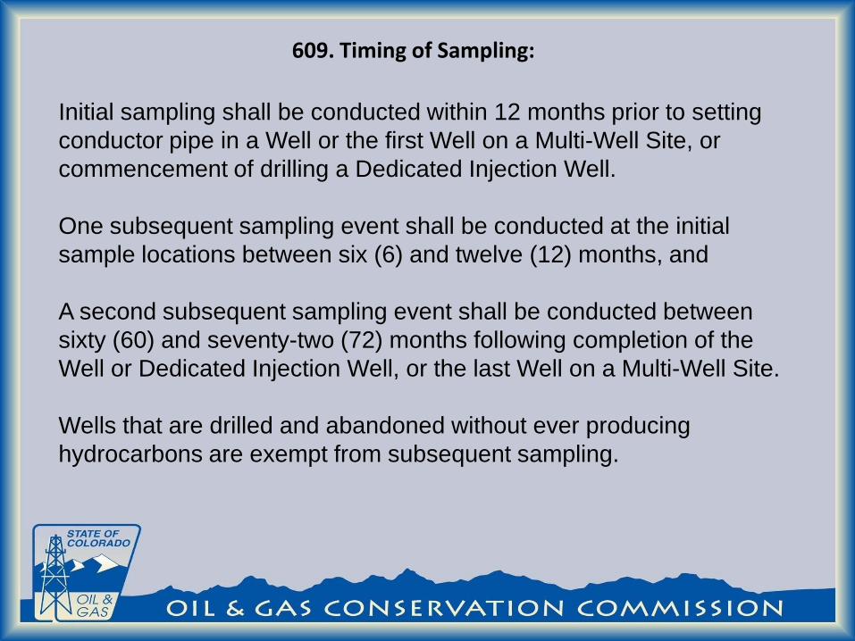
609. Timing of Sampling:
Initial sampling shall be conducted within 12 months prior to setting conductor pipe in a Well or the first Well on a Multi-Well Site, or commencement of drilling a Dedicated Injection Well. One subsequent sampling event shall be conducted at the initial sample locations between six (6) and twelve (12) months, and A second subsequent sampling event shall be conducted between sixty (60) and seventy-two (72) months following completion of the Well or Dedicated Injection Well, or the last Well on a Multi-Well Site. Wells that are drilled and abandoned without ever producing hydrocarbons are exempt from subsequent sampling.
609. Previously sampled Water Sources. In lieu of conducting the initial sampling required pursuant to subsection d.(1) or the second subsequent sampling event required pursuant to subsection d.(2), an Operator may rely on water sampling analytical results obtained from an Available Water Source within the sampling area provided: The previous water sample was obtained within the 18 months preceding the initial sampling event or the second subsequent sampling event required. The sampling procedures, including the constituents sampled for, and the analytical procedures used for the previous water sample were substantially similar to those required. The request to use a previous sample will be done with the Eform Sundry Notice.
609. Previously sampled Water Sources.
Sampling and analysis shall be conducted in conformance with an accepted industry standard as described in Rule 910.b.(2). A model Sampling and Analysis Plan (“COGCC Model SAP”) will be posted on the COGCC website prior to May 1, and shall be updated periodically to remain current with evolving industry standards. Upon request, an operator shall provide its sampling protocol to the Director.

609. Analyte List
Analyte Initial
Baseline
Susequent
Sampling
Analyte Initial
Baseline
Susequent
Sampling
pH X magnesium X Xspecific conductance X manganese X
total dissolved solids (TDS) X X potassium X Xdissolved methane X X sodium X Xdissolved ethane X X barium X
dissolved propane X X boron Xtotal bicarbonate as CaCO3 X X selenium X
carbonate as CaCO3 X X strontium Xbromide X X iron related bacteria Xchloride X X sulfate reducing bacteria Xfluoride X X slime forming bacteria Xsulfate X X TPH X X
nitrate and nitrite as N X benzene X Xphosphorus X toluene X X
calcium X X ethylbenzene X Xiron X xylenes X X
609. Previously sampled Water Sources. If free gas or a dissolved methane concentration greater than 1.0 mg/l is detected in a water sample, gas compositional analysis and stable isotope analysis of the methane shall be performed to determine gas type. The operator shall notify the Director and the owner of the water well immediately if: A. the test results indicated thermogenic or a mixture of
thermogenic and biogenic gas;
B. the methane concentration increases by more than 5.0 mg/l between sampling periods; or C. the methane concentration is detected at or above 10 mg/l. The operator shall notify the Director immediately if BTEX compounds or TPH are detected in a water sample.
609. Sampling Results. Copies of all final laboratory analytical results shall be provided to the Director and the water well owner or landowner within three (3) months of collecting the samples. The analytical results, the surveyed sample Water Source locations, and the field observations shall be submitted to the Director in an Electronic Data Deliverable Format. (1) The Director shall make such analytical results available publicly by
posting on the Commission’s web site or through another means announced to the public.
(2) Upon request, the Director shall also make the analytical results and surveyed Water Source locations available to the Local Governmental Designee from the jurisdiction in which the groundwater samples were collected, in the same electronic data deliverable format in which the data was provided to the Director.

609. Exception Request
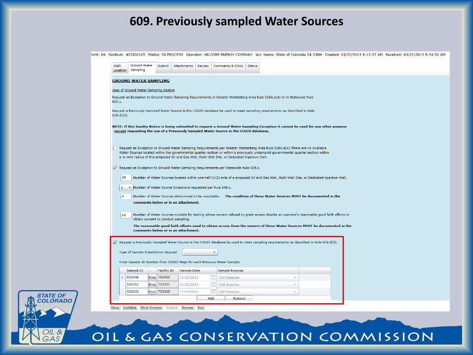
609. Previously sampled Water Sources

Web Access: https://cogcc.state.co.us/RbdmsEnv/
Contact information:
Arthur W. Koepsell [email protected]
303-894-2100 ext 5148

STEP 1: To get onto the system each individual who
is going to submit data on behalf of an Operator is required to have a Designation of Agent (Form 1A) on File with the COGCC prior to submitting Data. A blank Form 1A can be downloaded from: http://cogcc.state.co.us Once the Form is submitted a user name and temporary password will be submitted by COGCC staff.

STEP 2: Log on to the System at:
https://cogcc.state.co.us/RbdmsEnv/

HOMEPAGE After login the user is brought to
the home page.

The query builder can be used to search for locations

Clauses can be added to the query builder to narrow results
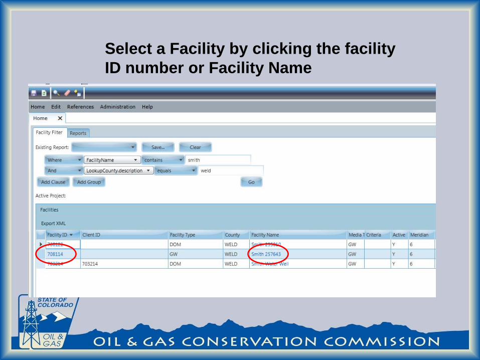
Select a Facility by clicking the facility ID number or Facility Name

Location information can be found on the location Tab of the Facility Edit page.

Sample information can be found on the bottom of the Facility Edit page.

Clicking on the Sample ID number takes the user to the Sample Page

Locations are kept unique by using the Latitude and Longitude of the Sample point. Prior to creating a new location the user should check to see if the location has been sampled before. The COGCC maps can be used to find previously sampled locations.
Creating Locations

The map can be found on the COGCC website at: http://dnrwebcomapg.state.co.us/mg2010app/ Select the Add Point Tool
Creating Locations

Place the latitude and longitude in the Point Capture Tool and click the add point button.
Creating Locations

A red X should appear on the map at the sample location
Creating Locations

Turn on sample layer on the left side of the map screen. In this case no new Facility ID is needed.
Creating Locations

If no diamond or triangle appear near the sample point latitude and longitude than a new Facility ID can be created
Creating Locations
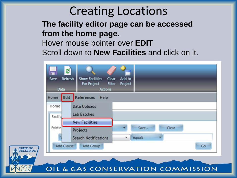
The facility editor page can be accessed from the home page. Hover mouse pointer over EDIT Scroll down to New Facilities and click on it.
Creating Locations

Click or green arrow to create a new record. Enter Facility Name.
Creating Locations
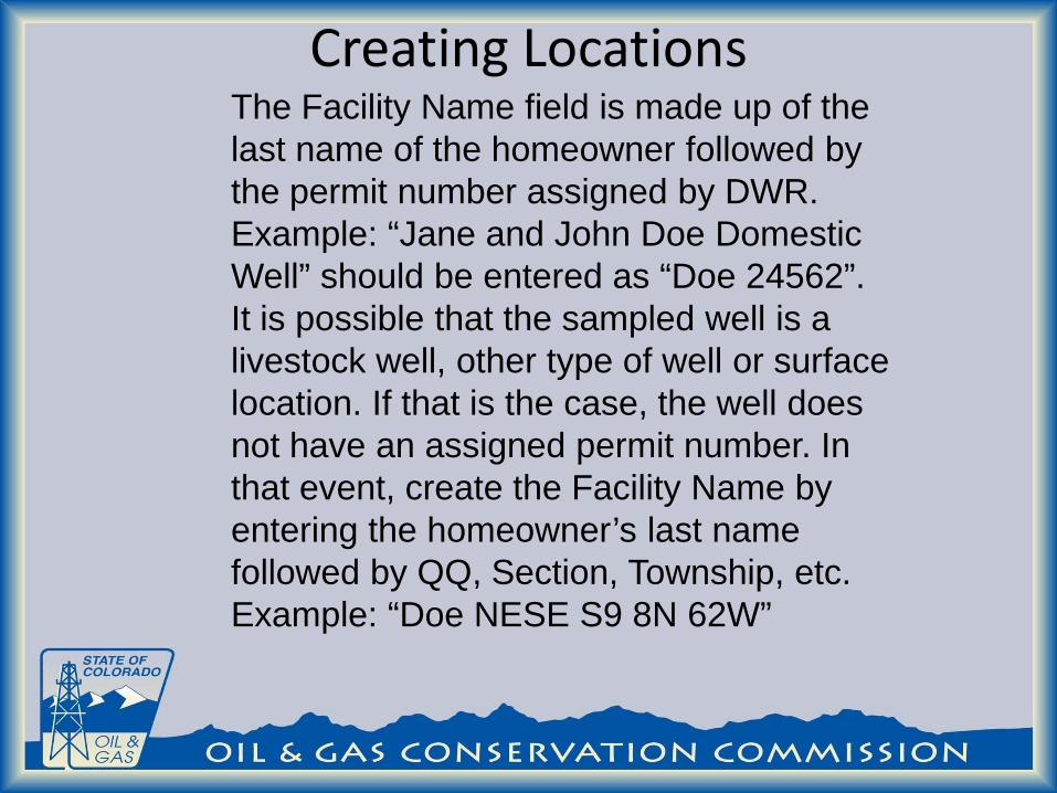
The Facility Name field is made up of the last name of the homeowner followed by the permit number assigned by DWR. Example: “Jane and John Doe Domestic Well” should be entered as “Doe 24562”. It is possible that the sampled well is a livestock well, other type of well or surface location. If that is the case, the well does not have an assigned permit number. In that event, create the Facility Name by entering the homeowner’s last name followed by QQ, Section, Township, etc. Example: “Doe NESE S9 8N 62W”
Creating Locations

Creating Locations Click on Enter Address button (shown on figure below).
Click on green arrow

Creating Locations Click on green +
Enter Address1, City, State (as CO), and Postal Code data. Click on Save and Set Actions button. This tab will close and New Facilities tab is now visible.
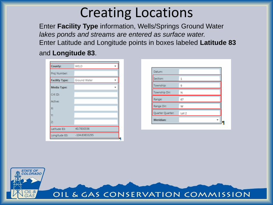
Creating Locations Enter Facility Type information, Wells/Springs Ground Water lakes ponds and streams are entered as surface water. Enter Latitude and Longitude points in boxes labeled Latitude 83 and Longitude 83.

Creating Locations Enter operator name for the COORD Source. DWR Permit #, Receipt # and Well Depth if available
Uploading Data Data is required to be submitted to the database by formatted Electronic Data Deliverable (EDD). Two versions of the EDD are accepted an Excel Version and an XML version. The XML is the preferred version. Information regarding the COGCC formatted EDD can be found at: http://rbdmsonline.org/RbdmsEnv/Help/CO_ExampleLabDataSpreadsheet.xls http://www.rbdmsonline.org/xml/COEnvEDD/COEnvEDD.html

Uploading Data The EDD must include the Facility_ ID number to be accepted into the database.

Uploading Data The upload utility can be found under the Edit menu.

Uploading Data Click on Import an EDD file and import to the database with a pending status button (see picture below). In your computer, locate the EDD to be uploaded. Click Open. The selected EDD will now appear on the screen. Click on the arrow to the left of the record to select the row to validate. Click on Parse and validate the EDD batch button. Under Sort, on the left side of the screen, click on Accepted. The uploaded EDD should appear on that list of records. .

Uploading Data To review the analytical data in the EDD or complete the sample record select the review EDD in the accepted screen.

Uploading Data To edit the sample information highlight the sampleID to be edited .

Uploading Data Information regarding the sample is located on the right of the screen..

Uploading Data Information regarding the associated Oil and Gas well can now be added to sample before verification. This creates a relationship between an oil and gas well and the water sample. Multiple wells can be associated with one sample water sample.

Uploading Data The Oil and Gas well can be found by entering the county code and sequence number . Once selected the operator number , operator name and facility Name auto-populate.

Uploading Data The sample reason is then added by a drop down list. One sample could be utilized to meet the sample requirements of more than one oil and gas well. For example a post drilling sample from one well could be used as the pre drilling sample for a different well.

Uploading Data Once the changes have been made to the sample information the changes can be saved by clicking the save button in the upper left of
the screen. Final Acceptance and verification is done by COGCC staff.

Web Access: https://cogcc.state.co.us/RbdmsEnv/
Contact information:
Arthur W. Koepsell [email protected]
303-894-2100 ext 5148