RUGBY RADIO STATION, RUGBY DEVELOPMENT SPECIFICATION submission 2011... · RUGBY RADIO STATION,...
30
RUGBY RADIO STATION, RUGBY DEVELOPMENT SPECIFICATION David Lock Associates on behalf of Rugby Radio Station Limited Partnership February 2011
Transcript of RUGBY RADIO STATION, RUGBY DEVELOPMENT SPECIFICATION submission 2011... · RUGBY RADIO STATION,...
RUGBY RADIO STATION, RUGBY
DEVELOPMENT SPECIFICATION
David Lock Associates
on behalf of Rugby Radio Station Limited Partnership
February 2011

CONTENTS 1.0 INTRODUCTION ............................................................................................................3
Purpose of the Development Specification ...............................................................3 Structure of the Development Specification..............................................................4
2.0 THE OUTLINE PLANNING APPLICATION ..................................................................5 Proposed Uses and Floorspace..................................................................................6 Proposed Development Programme and Sequencing .............................................6
3.0 PARAMETER PLANS....................................................................................................7 Parameter Plan A: Planning Application Boundary..................................................7 Parameter Plan B: Development Framework Plan ....................................................7 Parameter Plan C: Access and Movement.................................................................7 Parameter Plan D: Green Infrastructure Plan ............................................................7 Parameter Plan E: Development Parcels ...................................................................7 Parameter Plan G: Massing .........................................................................................8 Parameter Plan H: Development Sequencing Plan...................................................8
4.0 DEVELOPMENT FIXES .................................................................................................9 Built Development Floorspace....................................................................................9 Residential Development ...........................................................................................10
Quantum and Housing Mix......................................................................................10 Density ......................................................................................................................10
Non-Residential Development...................................................................................10 Retail Uses ................................................................................................................10 Commercial Development (Use Class B1, B2, B8) ...............................................11 Hotel ..........................................................................................................................11 Social and Community Infrastructure & Leisure Uses.........................................12 Retention of the listed ‘C’ Station...........................................................................13 Retention of other existing buildings.....................................................................13
Mixed Use Areas .........................................................................................................13 Maximum Height, Length and Width of Buildings...................................................13 Open Space Provision, Green Infrastructure and Biodiversity .............................14
Formal and Informal Open Space...........................................................................14 New Woodland and Bund........................................................................................15 Water Courses, Attenuation Lakes and Ponds .....................................................15 Hedgerows ................................................................................................................15 Productive Landscapes – Orchards and Allotments............................................15 Green Infrastructure & Biodiversity Strategy........................................................16
Primary and Secondary Streets ................................................................................16 Local Routes ...............................................................................................................17 Footpath Connections................................................................................................17 Energy..........................................................................................................................17 Sustainability...............................................................................................................18 Flood Risk....................................................................................................................18 Development Parcels .................................................................................................19
APPENDICES Appendix A: Parameter Plans

Rugby Radio Station Sustainable Urban Extension
Development SpecificationRugby Radio Station Limited Partnership
David Lock Associates February 2011
3
1.0 INTRODUCTION 1.1 This Development Specification defines the development for which approval has
been sought by means of an Outline Planning Application (OPA) with details of the
A428 accesses submitted in full. The OPA is submitted on behalf of Rugby Radio
Station Limited Partnership for the comprehensive redevelopment of approximately
483.5 hectares of land known as the Rugby Radio Station. This document has been
prepared to ensure that there is sufficient information and certainty about what is
proposed.
Purpose of the Development Specification
1.2 This Development Specification, incorporating the Parameter Plans, provides
sufficient information to define the scheme for which planning permission is sought
and which has been assessed through the Environmental Impact Assessment. The
Development Specification also provides sufficient information to meet the
regulations on outline planning applications (Guidance on information requirements
and validation, March 2010). With regard to the full details of the A428 accesses,
these do not require further definition given that all details are provided on the
relevant planning application drawings and associated information. Therefore these
are not detailed further in this Development Specification.
1.3 The Development Specification should be read in conjunction with the Parameter
Plans (Section 3 of this document), the Design and Access Statement and other
documents that support the Outline Planning Application. An ‘Illustrative’ Master
Plan has also been prepared, which demonstrates how the Application Site could be
developed within the defined Development Specification and the Parameter Plans.
1.4 It is the intention of RRSLP that the Parameter Plans described in Section 3 and
appended at Appendix A, and the Development Fixes in Section 4 should act as a
single reference to condition the planning permission to ensure that aspects of the
scheme as detailed in the outline planning permission are fixed. This will assist in
delivery of a high quality development.
1.5 The development shall be carried out in accordance with the Parameter Plans
appended at Appendix A and as described in Sections 3 and 4 of this document,
unless otherwise approved in writing by the local authority. A planning condition
would be imposed upon the granting of Outline Planning Consent requiring all
subsequently submitted reserved matters details to generally conform with the
Rugby Radio Station Sustainable Urban Extension
Development SpecificationRugby Radio Station Limited Partnership
David Lock Associates February 2011
4
detailed parameters outlined within the Parameter Plans described in Section 3 and
provided in Appendix A, and the Development Fixes set out in Section 4.
Structure of the Development Specification
1.6 Section 2 of this document provides information about the Application Site and
proposals for which outline planning permission is sought (the Parameter Plans).
The Parameter Plans cover a range of issues including uses, the principle means of
access and circulation, massing, landscaping and open space, and development
sequencing. Section 4 then sets out in words all other matters besides those
indicated on the Parameter Plans, which are also to be fixed at this stage.
Section 1: Introduction
Section 2: The Outline Planning Application
Section 3: Parameter Plans
Section 4: Development Fixes
Appendix A: Parameter Plans
Rugby Radio Station Sustainable Urban Extension
Development SpecificationRugby Radio Station Limited Partnership
David Lock Associates February 2011
5
2.0 THE OUTLINE PLANNING APPLICATION 2.1 The Outline Planning Application (OPA) reserves all matters for future determination
except the access points on the A428. The OPA site is identified on the Parameter
Plan A: Planning Application Boundary. The OPA is described in detail in the Design
and Access Statement and in the Environmental Statement. In addition, more
detailed descriptions of the proposals and mitigation measures are provided in the
relevant sections of the Environmental Statement.
2.2 The full description of development is as follows:
Description of Development ‘Outline planning application for an urban extension to Rugby for up to 6,200
dwellings together with up to 12,000 m² retail (A1), up to 3,500 m² financial services
(A2) and restaurants (A3-A5), up to 3,500 m² for a hotel (C1), up to 2,900 m² of
community uses (D1), up to 3,100 m² assembly and leisure uses (D2), up to 106,000
m² commercial and employment space (B1, B2 and B8), and ancillary facilities; a
mixed use district centre and 3 subsidiary local centres; land reserved for a
secondary school and 3 primary schools; public art; green infrastructure including,
formal and informal open space and amenity space; retained existing hedgerows,
ridge and furrow and areas of grassland; new woodland areas, allotments and areas
for food production, wildlife corridors; supporting infrastructure (comprising utilities
including gas, electricity, water, sewerage, telecommunication, renewable energy
infrastructure, energy centre(s) and diversions as necessary); sustainable urban
drainage systems including ponds, lakes and water courses; a mixed use traffic route
to Rugby, connections to the surrounding highway, cycleway and pedestrian network
and ground remodelling.’

Rugby Radio Station Sustainable Urban Extension
Development SpecificationRugby Radio Station Limited Partnership
David Lock Associates February 2011
6
Proposed Uses and Floorspace 2.3 The total proposed built floorspace for the non-residential principle uses would be
within the maximum floorspace thresholds set out in Table 2.1 below. In addition up
to 6,200 residential dwellings are proposed (TCPA Use Class Order 2005: C3).
Table 2.1: Non-Residential Land Use Schedule of the SUE TCPA Use Class Order 2005 Use Non-residential Floorspace (m²) A1 Retail Up to 12,000 A2 Financial Etc A3,4,5 Restaurants etc Up to 3,500 B1(a,b,c) Up to 75,000 B2 Up to 15,500 B8
Employment Up to 15,500
C1 Hotel Up to 3,500
D1 Community Up to 2,900
D1 Secondary School Up to 10,000
D1 Primary School Up to 10,200
D2 Assembly and Leisure Up to 3,100
Sui Generis Up to 200 Total Up to 151,400
Note 1: The table shown above excludes potential floorspace in the listed ‘C’ Station, which is to be retained. If a requirement for another major use emerges it will be subject to a separate application.
Proposed Development Programme and Sequencing
2.4 It is anticipated that residential development would start in 2013. This would follow
site preparatory works. Thereafter the pace of development will be dependent on
market conditions.
2.5 It is envisaged that the first sequence of development would gain access from the
A428 and residential units would be developed along the primary route terminating at
the ‘C’ Station. This sequence would include the first primary school, the first local
centre and first elements of the District Centre.
Rugby Radio Station Sustainable Urban Extension
Development SpecificationRugby Radio Station Limited Partnership
David Lock Associates February 2011
7
3.0 PARAMETER PLANS 3.1 The disposition of land uses and open space has evolved through detailed analysis
of the wider location and contextual influences and a rigorous consideration of how
the site and the proposed development would best relate to the surrounding existing
and planned land uses, infrastructure, established landscape, areas of natural
interest and local route networks.
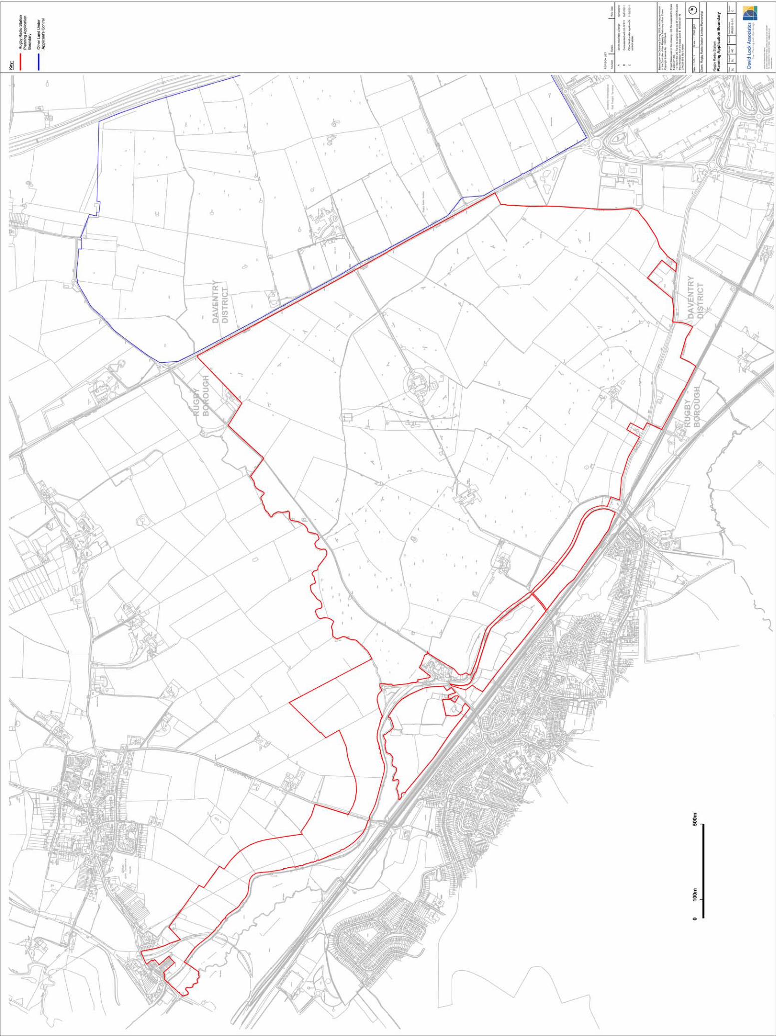
Parameter Plan A: Planning Application Boundary
3.2 This plan fixes the application boundary and indicates adjacent land under controlled
and ownership by the Joint Venture RRSLP.
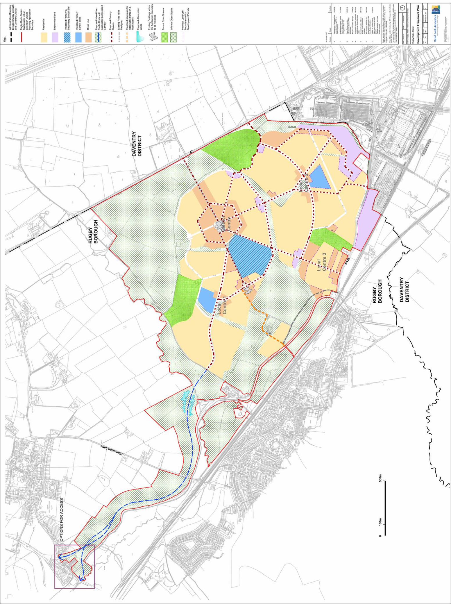
Parameter Plan B: Development Framework Plan
3.3 This plan fixes the type and disposition of the various land uses proposed within the
SUE. The areas of primary infrastructure, built development and open space and
landscape are also shown.
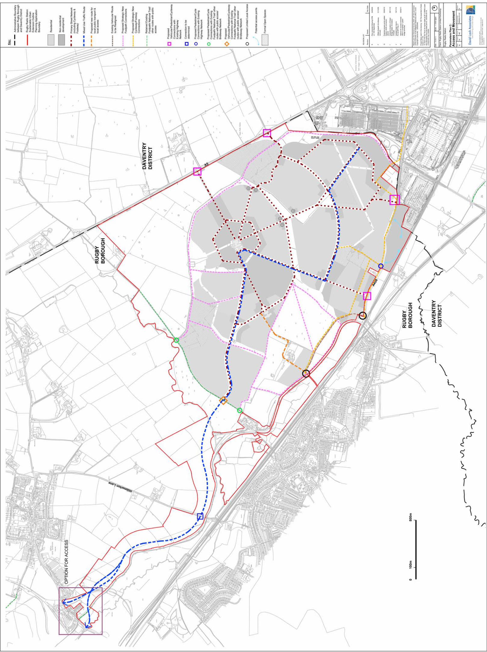
Parameter Plan C: Access and Movement
3.4 This plan sets out the primary access points into the site from the surrounding cycle,
pedestrian, and road network. It also shows the movement corridors and networks
across the site.
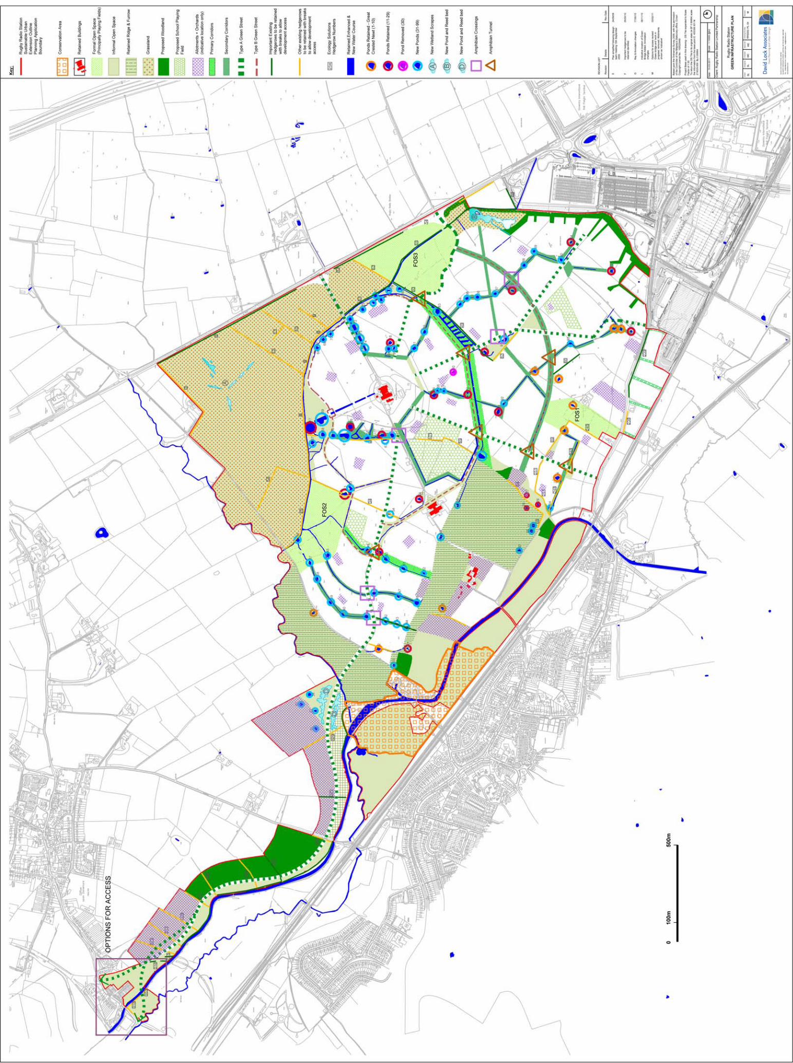
Parameter Plan D: Green Infrastructure Plan 3.5 This plan shows how existing landscape elements have been retained and
incorporated into the development framework, how this influences the network of new
green infrastructure which runs through and around the development area. This plan
also defines the retained and proposed habitat areas and corridors.
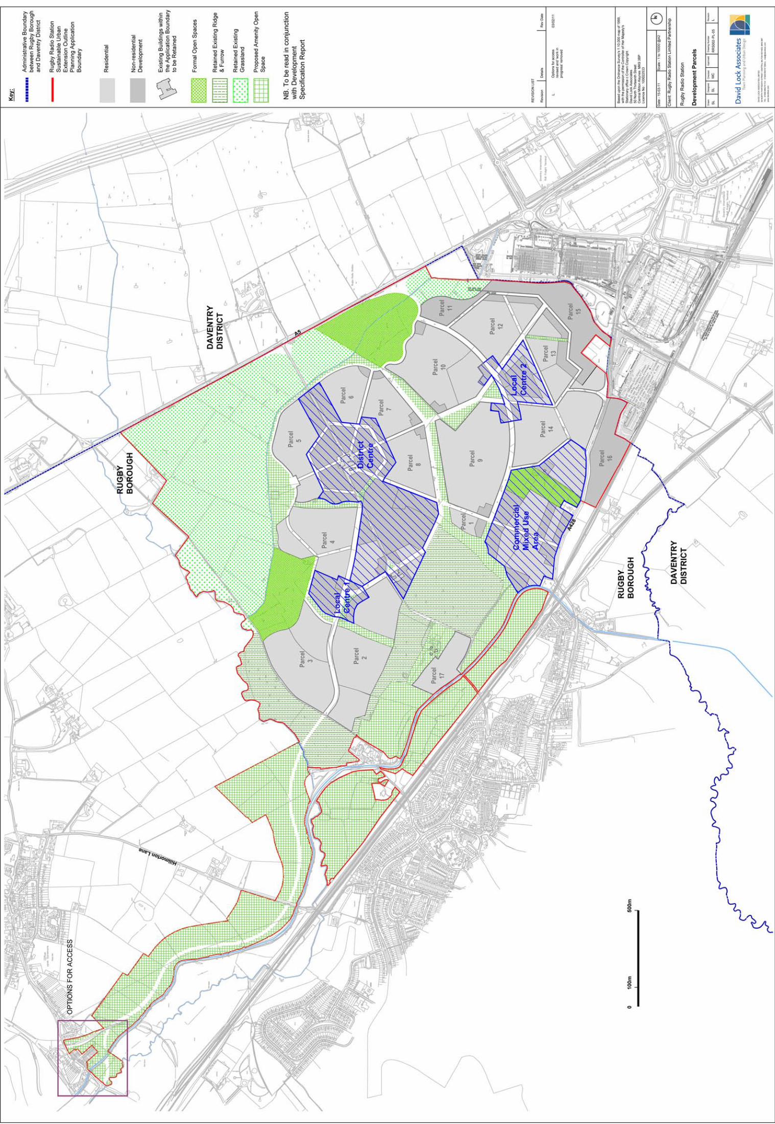
Parameter Plan E: Development Parcels
3.6 This plan sets out existing buildings within the application boundary and shows where
new built development is proposed and whether it is residential or non-residential
development. The plan also shows areas of Formal Open Space, Proposed Amenity
Open Space, retained existing ridge and furrow, and retained existing grassland.
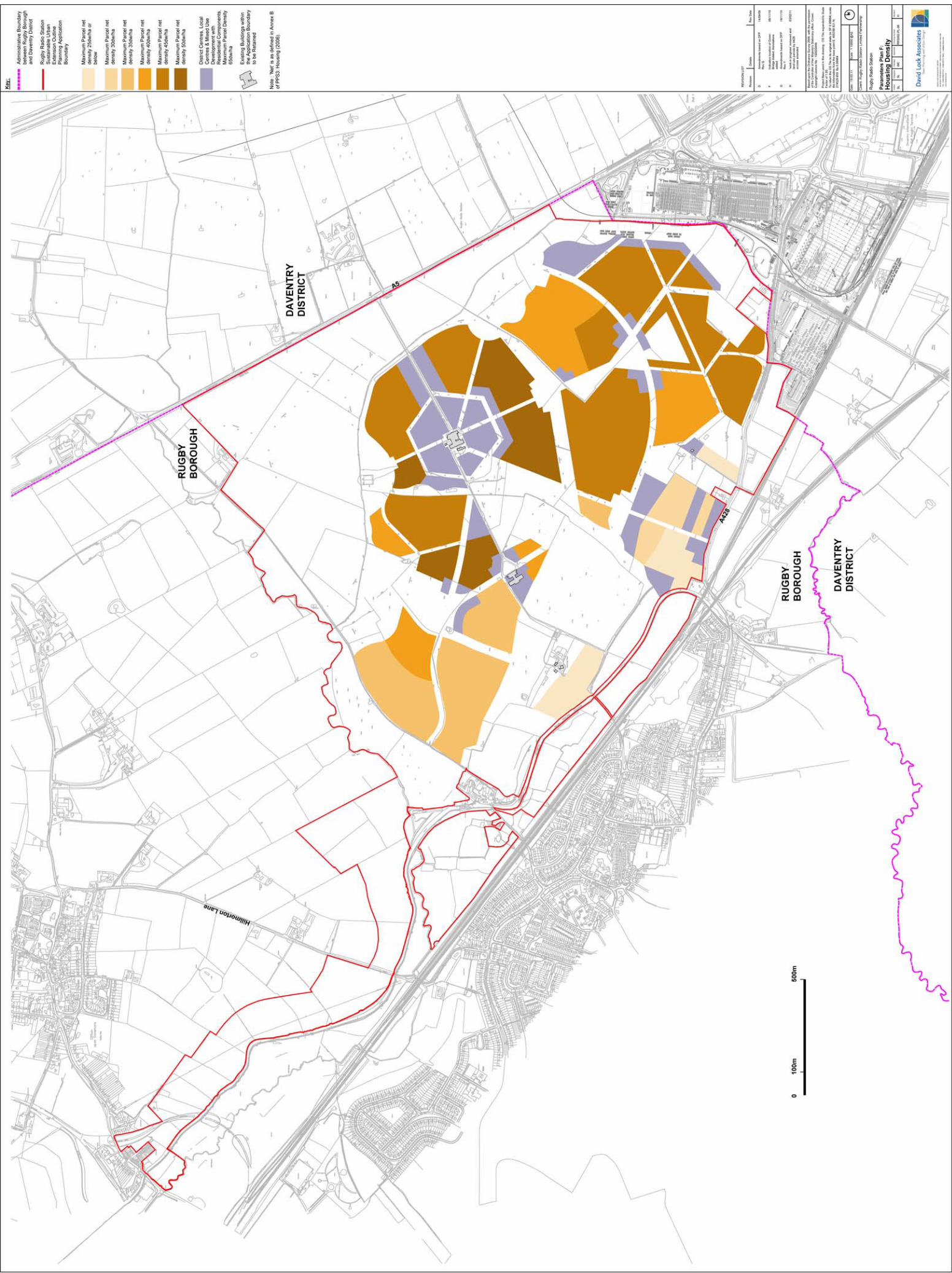
Parameter Plan F: Density
3.7 This plan sets out the density ranges for RRS. Densities range from a maximum of
25dph in the peripheral parts of the site to a maximum parcel density of 65dph in the
residential component of the district, local and mixed used centres.
Rugby Radio Station Sustainable Urban Extension
Development SpecificationRugby Radio Station Limited Partnership
David Lock Associates February 2011
8
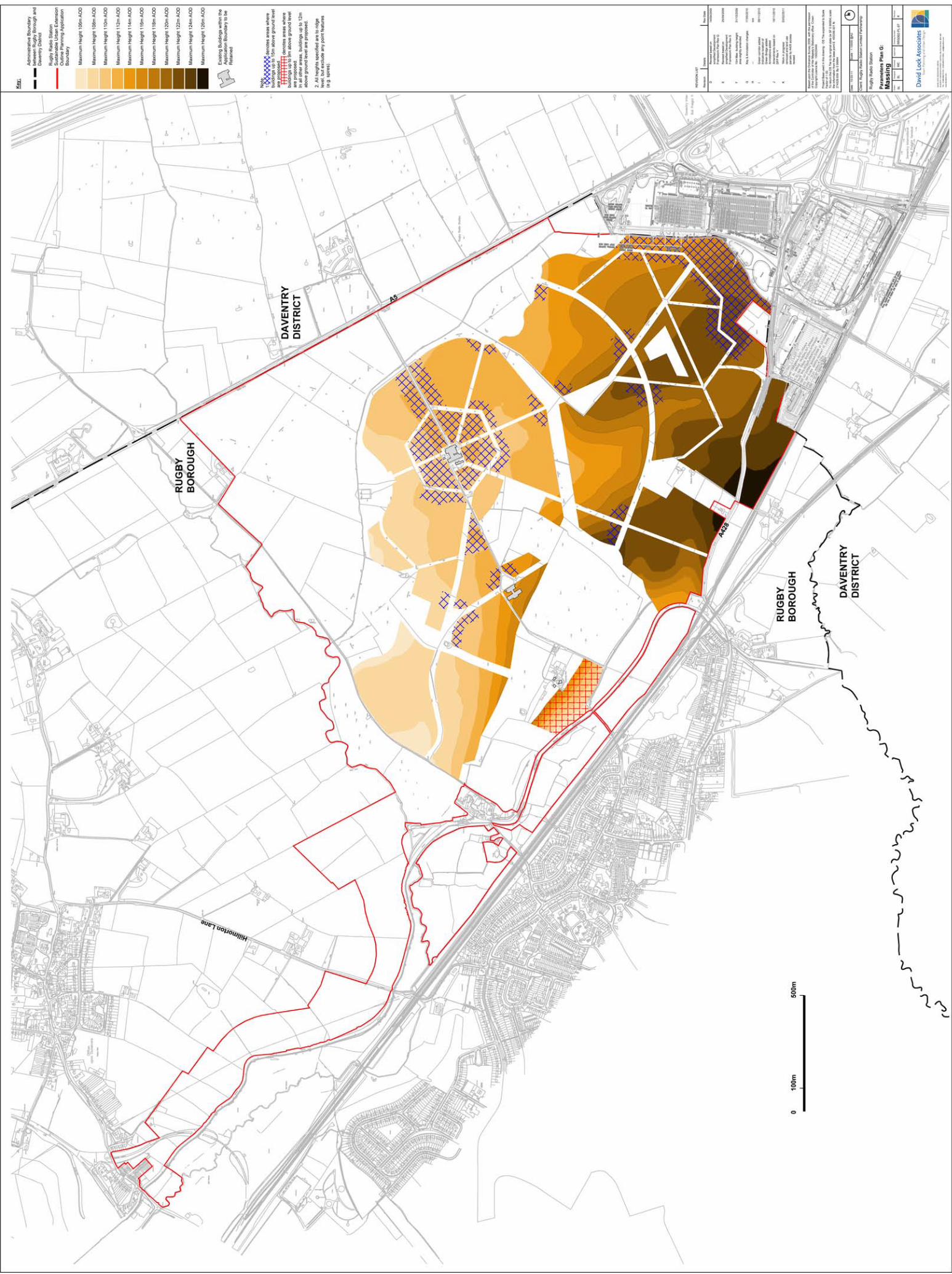
Parameter Plan G: Massing 3.8 This plan shows the maximum building heights within each area of the proposed
development. This is provided as maximum heights above Ordnance data (AOD).
The plan also denotes areas where buildings would be up to 9 m, 12m and 15m
above ground level. The plan includes provision for landmark or gateway buildings at
key entrances or intersections within the site.
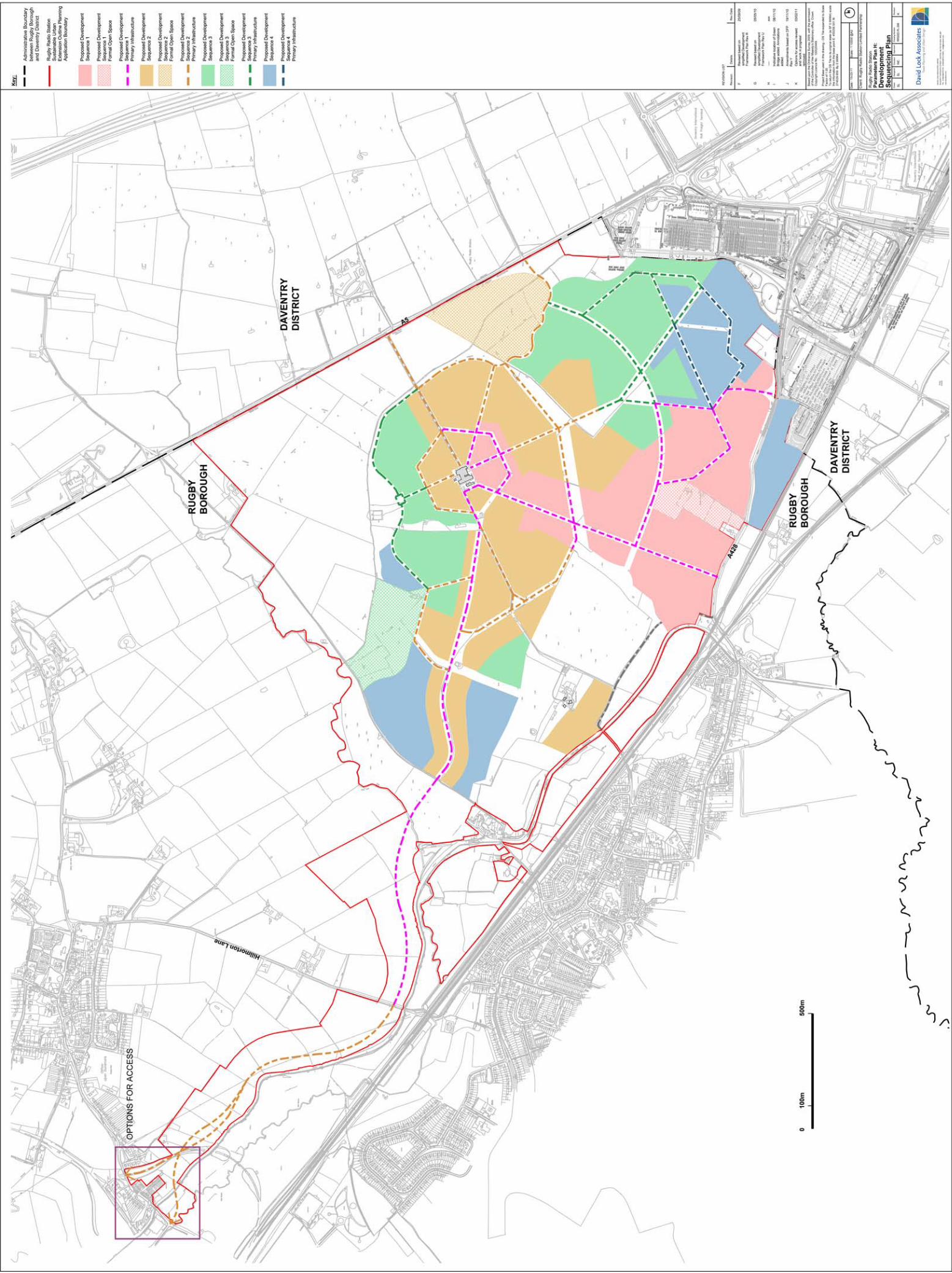
Parameter Plan H: Development Sequencing Plan
3.9 This plan outlines the proposed phasing strategy for the development, showing the
proposed sequence of development parcels, open space and primary infrastructure.
Rugby Radio Station Sustainable Urban Extension
Development SpecificationRugby Radio Station Limited Partnership
David Lock Associates February 2011
9
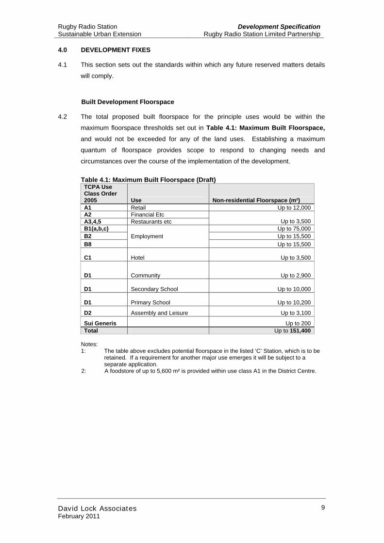
4.0 DEVELOPMENT FIXES 4.1 This section sets out the standards within which any future reserved matters details
will comply.
Built Development Floorspace 4.2 The total proposed built floorspace for the principle uses would be within the
maximum floorspace thresholds set out in Table 4.1: Maximum Built Floorspace, and would not be exceeded for any of the land uses. Establishing a maximum
quantum of floorspace provides scope to respond to changing needs and
circumstances over the course of the implementation of the development.
Table 4.1: Maximum Built Floorspace (Draft) TCPA Use Class Order 2005 Use Non-residential Floorspace (m²) A1 Retail Up to 12,000 A2 Financial Etc A3,4,5 Restaurants etc Up to 3,500 B1(a,b,c) Up to 75,000 B2 Up to 15,500 B8
Employment Up to 15,500
C1 Hotel Up to 3,500
D1 Community Up to 2,900
D1 Secondary School Up to 10,000
D1 Primary School Up to 10,200
D2 Assembly and Leisure Up to 3,100
Sui Generis Up to 200 Total Up to 151,400
Notes: 1: The table above excludes potential floorspace in the listed ‘C’ Station, which is to be
retained. If a requirement for another major use emerges it will be subject to a separate application.
2: A foodstore of up to 5,600 m² is provided within use class A1 in the District Centre.
Rugby Radio Station Sustainable Urban Extension
Development SpecificationRugby Radio Station Limited Partnership
David Lock Associates February 2011
10
Residential Development
Quantum and Housing Mix 4.3 The residential floorspace will be constructed to provide up to 6,200 residential units
within a range of tenures and unit sizes to be agreed with the local planning authority.
The intention is that the development will provide a proportion of affordable housing
units split between private, social rented and intermediate housing.
Density 4.4 The variety and range of housing across the site will generate an average of 39
dwellings per hectare (dph) across the site as a whole. Density will range across
plots with some areas as low as 20 dph in some areas and up to 65 dph in other
areas, such as adjacent to the District Centre. This seeks to ensure that a range of
housing types can be accommodated across the development, including family
homes and homes to serve niche markets, and higher density development close to
public transport infrastructure and local and district centres.
Non-Residential Development
Retail Uses
4.5 The location of retail floorspace (A1-A5 uses) will be located within the following
Development Parcels up to a maximum of 12,000 m² A1 use and 3,500 m² of A2-A5
uses:
• District Centre • Local Centre 1; • Local Centre 2; • Local Centre 3; • Parcel 10; • Parcel 12; and • Parcel 13.
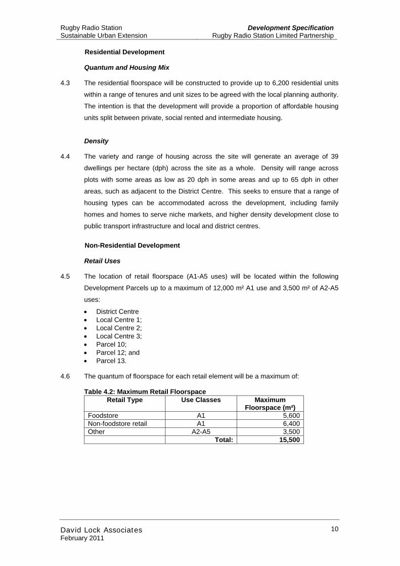
4.6 The quantum of floorspace for each retail element will be a maximum of:
Table 4.2: Maximum Retail Floorspace Retail Type Use Classes Maximum
Floorspace (m²) Foodstore A1 5,600 Non-foodstore retail A1 6,400 Other A2-A5 3,500 Total: 15,500
Rugby Radio Station Sustainable Urban Extension
Development SpecificationRugby Radio Station Limited Partnership
David Lock Associates February 2011
11
Commercial Development (Use Class B1, B2, B8)
4.7 The commercial development (B1, B2, B8 uses) will be located within the following
Development Parcels up to a maximum of 106,000 m²:
• District Centre;
• Local Centre 2;
• Local Centre 3;
• Parcel 1
• Parcel 6;
• Parcel 7;
• Parcel 8;
• Parcel 9;
• Parcel 10;
• Parcel 11;
• Parcel 12;
• Parcel 13;
• Parcel 14;
• Parcel 15; and
• Parcel 16.
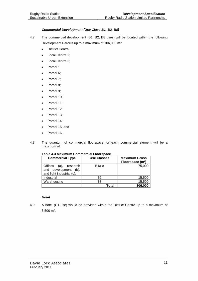
4.8 The quantum of commercial floorspace for each commercial element will be a
maximum of:
Table 4.3 Maximum Commercial Floorspace Commercial Type Use Classes Maximum Gross
Floorspace (m²) Offices (a), research and development (b), and light industrial (c);
B1a-c 75,000
Industrial B2 15,500 Warehousing B8 15,500 Total: 106,000
Hotel
4.9 A hotel (C1 use) would be provided within the District Centre up to a maximum of
3,500 m².
Rugby Radio Station Sustainable Urban Extension
Development SpecificationRugby Radio Station Limited Partnership
David Lock Associates February 2011
12
Social and Community Infrastructure & Leisure Uses 4.10 A range of social and community facilities and leisure uses will be provided within the
development. These will comprise:
• Three primary schools; • One secondary school; • Health facilities; • Community facilities; and • Leisure facilities.
4.11 The schools will be located in the Development Parcels District Centre and Local
Centres 1 and 2. The broad location for the schools and the school playing fields is
shown on the Parameter Plans. Co-location of services will be sought wherever
possible. One of the primary schools and the secondary school within the District
Centre Parcel will be co-located with potential to form a single ‘campus site’. All of
the school sites will be designed to provide dual use facilities for use by both students
and the community wherever practicable. The potential for shared use of some
community facilities is under exploration. The detailed design, location and
orientation of the schools and the playing fields will be discussed at a subsequent
design stage with the relevant planning and education authorities.
4.12 The location for health facilities will be within local neighbourhood centres and the
District centre with the exact locations to be determined through more detailed
discussions with the local authority and the NHS to ensure adequate services will
meet the needs of the new population. Facilities for pharmacies, dentist and
opticians may be provided as part of a health centre or as is often the case, in retail
premises.
4.13 Leisure facilities would be provided up to a maximum of 3,100 m². The type of
leisure facilities is yet to be determined.
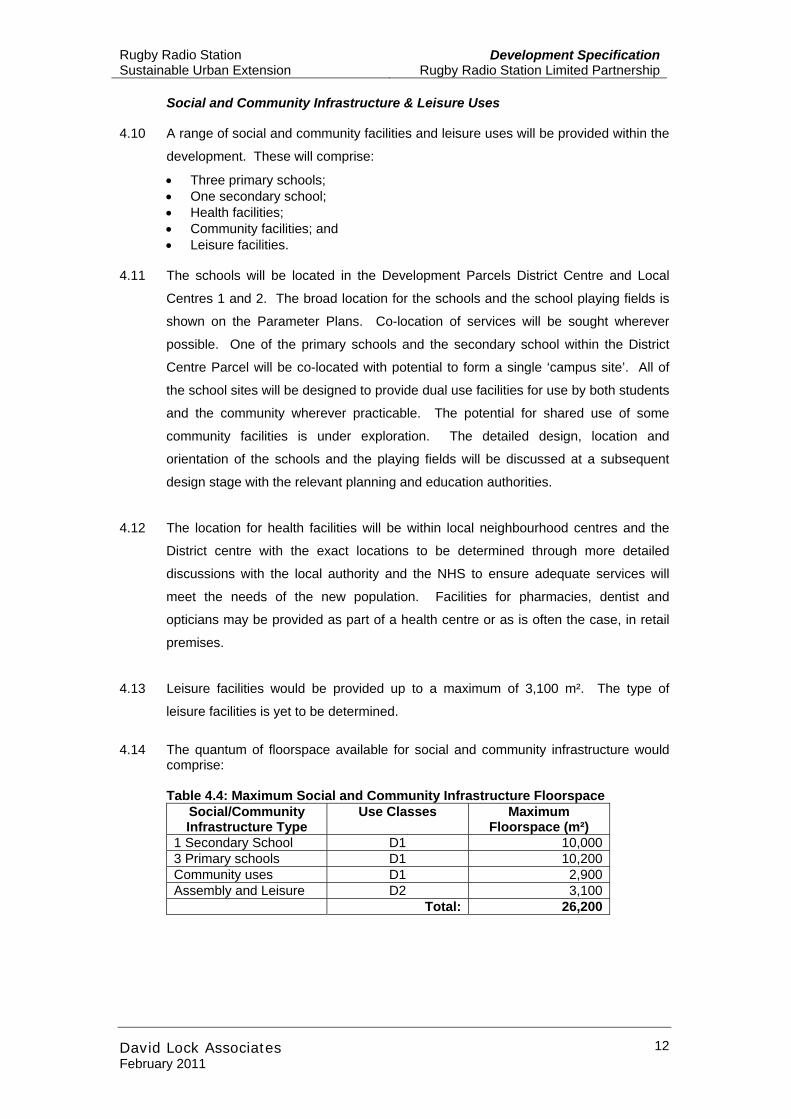
4.14 The quantum of floorspace available for social and community infrastructure would
comprise:
Table 4.4: Maximum Social and Community Infrastructure Floorspace Social/Community Infrastructure Type
Use Classes Maximum Floorspace (m²)
1 Secondary School D1 10,000 3 Primary schools D1 10,200 Community uses D1 2,900 Assembly and Leisure D2 3,100 Total: 26,200
Rugby Radio Station Sustainable Urban Extension
Development SpecificationRugby Radio Station Limited Partnership
David Lock Associates February 2011
13
Retention of the listed ‘C’ Station 4.15 It is intended that the listed ‘C’ Station is to be retained and would be re-used and
refurbished. A range of uses may be appropriate in this building, including
community uses. The quantum of floorspace would be additional to that set out in
this Development Specification. The existing avenue approach from the A5 to the
listed ‘C’ Station would be retained.
Retention of other existing buildings 4.16 It is intended that some existing buildings at Normandy Farm would be retained to
support the development of character and identity associated with new development
adjacent to the canal.
4.17 It is also intended that the farmhouse at Dolman’s Farm would be retained and have
a suitable new use. It will also continue to serve as an ecological habitat, and in
particular as a maternity bat roost habitat.
Mixed Use Areas 4.18 Mixed Use areas are shown on the Parameter Plans including the District Centre, the
three Local Centres and some other areas at high profile locations, on street corner
plots or along primary routes. These mixed use areas are intended to accommodate
more than one use with potential in some locations for both commercial and
community facilities/services to be accommodated at ground level with residential
units above. The mix of commercial and community facilities/services for each mixed
use area will vary and the components for each could include the following uses:
local shops and shops (A1-A5 uses), offices and/or workshops (B1 and B2 uses),
community spaces (D1 and D2 uses), hotel (C1 uses in the District Centre), and
residential (C3 uses). The mixed use would be integrated within residential
neighbourhoods and would be occupied by a range of business types and sizes.
Maximum Height, Length and Width of Buildings 4.19 The scale of the proposed development in terms of building heights is shown in
Parameter Plan G: Massing (RRS002-PL-007 Rev K). This indicates that building
heights will vary across the site in order to respond appropriately to the existing
topography and proposed uses. The maximum height will be up to 15 m (5 storeys)
above ground level in higher mixed use and employment areas. In the lower density
area west of Normandy Farm a reduced scale of development is sought with
buildings no taller than 9m above ground level (3 storeys). In all other medium
density areas the maximum building height will be 12m above ground level (4
storeys).
Rugby Radio Station Sustainable Urban Extension
Development SpecificationRugby Radio Station Limited Partnership
David Lock Associates February 2011
14
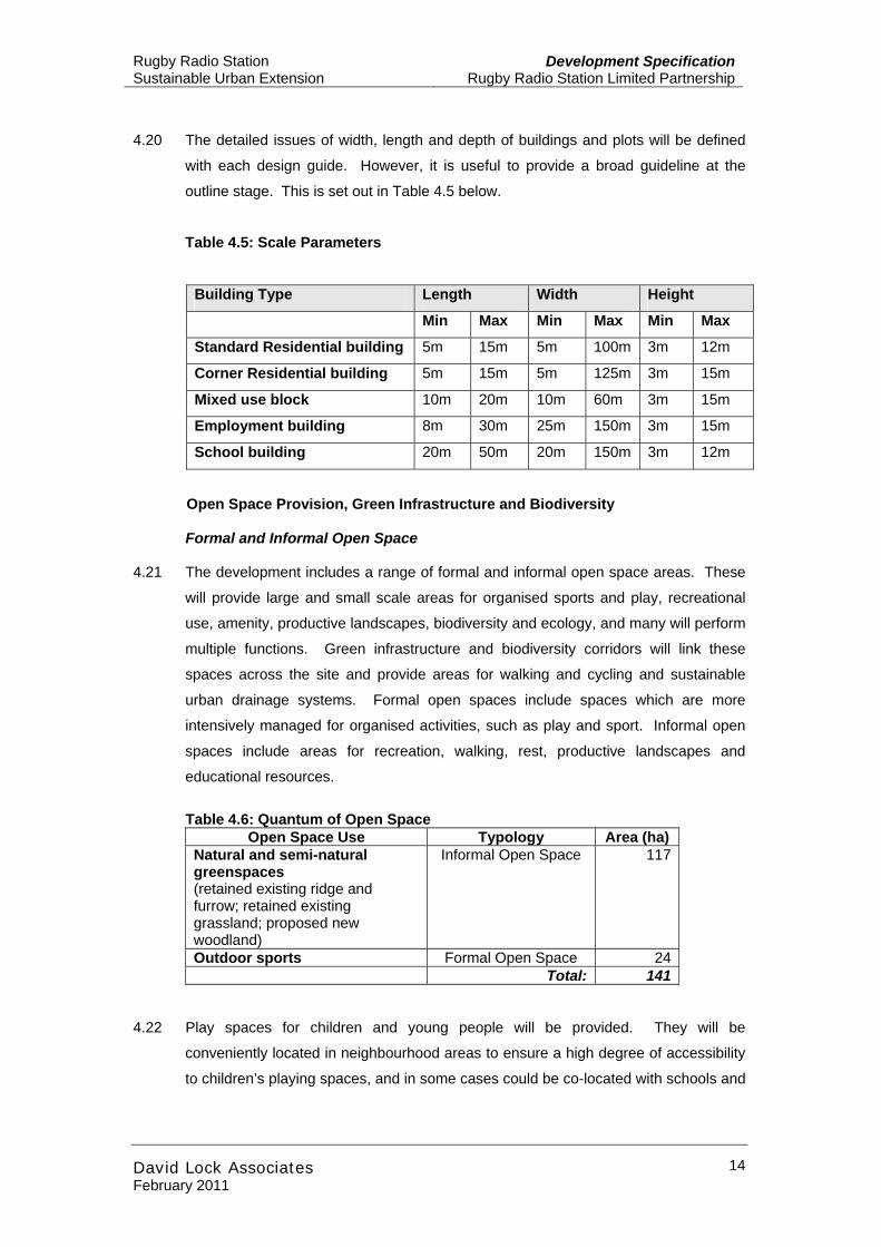
4.20 The detailed issues of width, length and depth of buildings and plots will be defined
with each design guide. However, it is useful to provide a broad guideline at the
outline stage. This is set out in Table 4.5 below.
Table 4.5: Scale Parameters
Building Type Length Width Height
Min Max Min Max Min Max
Standard Residential building 5m 15m 5m 100m 3m 12m
Corner Residential building 5m 15m 5m 125m 3m 15m
Mixed use block 10m 20m 10m 60m 3m 15m
Employment building 8m 30m 25m 150m 3m 15m
School building 20m 50m 20m 150m 3m 12m
Open Space Provision, Green Infrastructure and Biodiversity
Formal and Informal Open Space
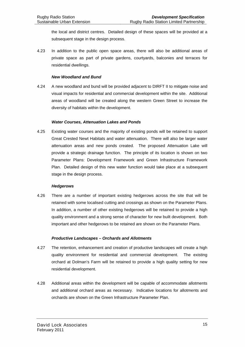
4.21 The development includes a range of formal and informal open space areas. These
will provide large and small scale areas for organised sports and play, recreational
use, amenity, productive landscapes, biodiversity and ecology, and many will perform
multiple functions. Green infrastructure and biodiversity corridors will link these
spaces across the site and provide areas for walking and cycling and sustainable
urban drainage systems. Formal open spaces include spaces which are more
intensively managed for organised activities, such as play and sport. Informal open
spaces include areas for recreation, walking, rest, productive landscapes and
educational resources.
Table 4.6: Quantum of Open Space
Open Space Use Typology Area (ha) Natural and semi-natural greenspaces (retained existing ridge and furrow; retained existing grassland; proposed new woodland)
Informal Open Space 117
Outdoor sports Formal Open Space 24 Total: 141
4.22 Play spaces for children and young people will be provided. They will be
conveniently located in neighbourhood areas to ensure a high degree of accessibility
to children’s playing spaces, and in some cases could be co-located with schools and
Rugby Radio Station Sustainable Urban Extension
Development SpecificationRugby Radio Station Limited Partnership
David Lock Associates February 2011
15
the local and district centres. Detailed design of these spaces will be provided at a
subsequent stage in the design process.
4.23 In addition to the public open space areas, there will also be additional areas of
private space as part of private gardens, courtyards, balconies and terraces for
residential dwellings.
New Woodland and Bund
4.24 A new woodland and bund will be provided adjacent to DIRFT II to mitigate noise and
visual impacts for residential and commercial development within the site. Additional
areas of woodland will be created along the western Green Street to increase the
diversity of habitats within the development.
Water Courses, Attenuation Lakes and Ponds 4.25 Existing water courses and the majority of existing ponds will be retained to support
Great Crested Newt Habitats and water attenuation. There will also be larger water
attenuation areas and new ponds created. The proposed Attenuation Lake will
provide a strategic drainage function. The principle of its location is shown on two
Parameter Plans: Development Framework and Green Infrastructure Framework
Plan. Detailed design of this new water function would take place at a subsequent
stage in the design process.
Hedgerows
4.26 There are a number of important existing hedgerows across the site that will be
retained with some localised cutting and crossings as shown on the Parameter Plans.
In addition, a number of other existing hedgerows will be retained to provide a high
quality environment and a strong sense of character for new built development. Both
important and other hedgerows to be retained are shown on the Parameter Plans.
Productive Landscapes – Orchards and Allotments 4.27 The retention, enhancement and creation of productive landscapes will create a high
quality environment for residential and commercial development. The existing
orchard at Dolman’s Farm will be retained to provide a high quality setting for new
residential development.
4.28 Additional areas within the development will be capable of accommodate allotments
and additional orchard areas as necessary. Indicative locations for allotments and
orchards are shown on the Green Infrastructure Parameter Plan.
Rugby Radio Station Sustainable Urban Extension
Development SpecificationRugby Radio Station Limited Partnership
David Lock Associates February 2011
16
Green Infrastructure & Biodiversity Strategy 4.29 The Green Infrastructure is shown on Parameter Plan D: Green Infrastructure. The
biodiversity elements of the green infrastructure are illustrated on the supporting
Biodiversity Plan.
Ponds
4.30 A network of new ponds will be created within the wildlife corridors to provide newt
habitats. These ponds will supplement the retained ponds located throughout the
development area.
Amphibian Crossings
4.31 Amphibian crossings will be provided at the intersections of the primary road network
and the wildlife corridors to maintain the connectivity of the corridors and decrease
the risk of amphibian mortality.
Wildlife Corridors
4.32 Two primary wildlife corridors are proposed to provide major connectivity between
areas of retained and created habitat and existing green spaces and ponds. Primary
wildlife corridors will have a minimum width of 60m.
4.33 Secondary wildlife corridors will also provide connectivity between areas of retained
and created habitat and will have a minimum width of 20m.
Ecological Park
4.34 Land for an ecological park will be provided between the railway and canal, on the
south western side of the SUE. The park will be specifically managed to create
lowland neutral grassland.
Grassland / Meadow
4.35 The area of open space to the north of the development area will be retained as
lowland grassland and meadow to increase biodiversity.
Primary and Secondary Streets 4.36 Primary and secondary streets will provide the two main street typologies for the
street network as shown on the Parameter Plans. Primary streets will provide direct
radial routes from the District Centre to the five primary access points. Secondary
streets will connect the primary streets and increase accessibility to residential areas,
local centres and mixed use areas.
Rugby Radio Station Sustainable Urban Extension
Development SpecificationRugby Radio Station Limited Partnership
David Lock Associates February 2011
17
4.37 Primary streets would include footways, cycleways, carriageways and public
transport lanes, and verges and swales including car parking and bus stop areas.
Secondary streets would include footways, cycleways, carriageways and public
transport lanes, and verges, swales, car parking and bus stops. Tree planting will be
an integral part of the character of the primary and secondary streets and will perform
a number of functions, including an important landscaping role. More details,
including illustrative drawings for each typology can be found in the Design and
Access Statement.
Local Routes 4.38 The development’s District Centre would be linked with the community of Hillmorton
via a proposed new route passing through Normandy Hill farm and following Lower
Street to pass underneath the West Coast Main Line railway. This route would make
use of some existing roads to create a new route for local public transport and local
access.
Footpath Connections 4.39 The Strategic New Footpath Connections shown on Parameter Plan C Access and
Movement would provide a comprehensive network of pedestrian routes across the
site to increase accessibility by sustainable modes.
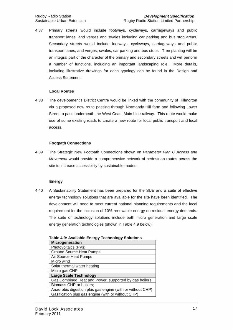
Energy 4.40 A Sustainability Statement has been prepared for the SUE and a suite of effective
energy technology solutions that are available for the site have been identified. The
development will need to meet current national planning requirements and the local
requirement for the inclusion of 10% renewable energy on residual energy demands.
The suite of technology solutions include both micro generation and large scale
energy generation technologies (shown in Table 4.9 below).
Table 4.9: Available Energy Technology Solutions Microgeneration Photovoltaics (PVs) Ground Source Heat Pumps Air Source Heat Pumps Micro wind Solar thermal water heating Micro gas CHP Large Scale Technology Gas Combined Heat and Power, supported by gas boilers Biomass CHP or boilers; Anaerobic digestion plus gas engine (with or without CHP) Gasification plus gas engine (with or without CHP)
Rugby Radio Station Sustainable Urban Extension
Development SpecificationRugby Radio Station Limited Partnership
David Lock Associates February 2011
18
4.41 The Sustainability Statement takes a resilience approach to understanding energy
demand and assessing the on-site capacity to generate energy and distribute energy.
This approach has been taken in light of the rapidly changing legislative programme,
technology advances and consumer demands that will occur over the next 20 years.
Change energy requirements and technologies will affect the best approach to
powering the SUE, and how a deliverable and sustainable energy infrastructure
provision can be developed.
4.42 Following this resilience approach, the formal decision on the actual energy
generation technology adopted for the site needs to be undertaken at a more detailed
design stage. Property energy demand can be established with more certainty and
the balanced energy generation requirements established.
4.43 To accommodate the energy requirements of the site it is anticipated that one or
more energy centres may be required. The actual energy plant type, size and
optimum location within the SUE will be decided at the detailed design stage. Should
this lead to an increase in the maximum proposed built floorspace for the SUE as set
out in Table 4.1, it will be subject to a separate detailed planning application.
Sustainability 4.44 All residential units will be designed to achieve the required current Code for
Sustainable Homes Level. Other sustainability measures will include:
• Water efficiency: ;
• Modal shift toward sustainable modes of transport (walking, cycling, public
transport);
• Energy efficiency:
• Renewable Energy:
• Waste management (recycling);
• Passive design of the urban environment to encourage day lighting and reduce
the need for lighting during the day; and
• Highly efficient buildings that reduce the electrical and heat energy demand.
Flood Risk 4.45 The proposals include an area in the Environment Agency’s Flood Zone. All built
development within the SUE will be located outside the floodplain within Flood Zone
1, which is appropriate for all land uses. The floodplain will be left undeveloped, as
formal and informal open space.
Rugby Radio Station Sustainable Urban Extension
Development SpecificationRugby Radio Station Limited Partnership
David Lock Associates February 2011
19
4.46 The Functional Flood Zone 3b is crossed by ‘Essential Infrastructure’, as defined in
PPS25. The three access roads which cross the floodplain are essential to the
development and meet the requirements of the Exception Test in PPS25. The
Environmental Statement and Planning Statement address the PPS25 Sequential
Test and Exception Test in detail.
4.47 The roads will be designed to comply with current legislation for safety and the Flood
Risk Assessment accompanying the OPA demonstrates that the development will
meet the definition of ‘safe’ as set out in Rugby’s Strategic Flood Risk Assessment.
The roads will be raised above the 100 year plus climate change level. Measures
such as flood relief culverts have been incorporated into the design to ensure that
there is no detriment offsite. A larger volume of flood storage will be provided as
compensation than is lost, providing additional floodplain storage. More detail is
included in the Flood Risk Assessment and Water chapter of the ES.
Development Parcels 4.48 Parameter Plan E Development Parcels defines individual development parcels
which have been used for Environmental Assessment purposes and for planning
implementation and development sequencing. This plan should be considered
alongside Parameter Plan B Development Framework Plan (DFP) and Parameter
Plan H Development Sequencing Plan. ‘Potential Land Use Boundaries’ on the DFP
show areas that would have some flexibility for minor amendments to the areas
defined within the Development Parcels (shown in Parameter Plan E Development
Parcels) at later design stages.
Rugby Radio Station Sustainable Urban Extension
Development SpecificationRugby Radio Station Limited Partnership
David Lock Associates February 2011
20
Appendix A: Parameter Plans