RSPO NOTIFICATION OF PROPOSED NEW PLANTING RSPO NOTIFICATION OF... · “Hasil Hutan Non-Kayu dalam...
20
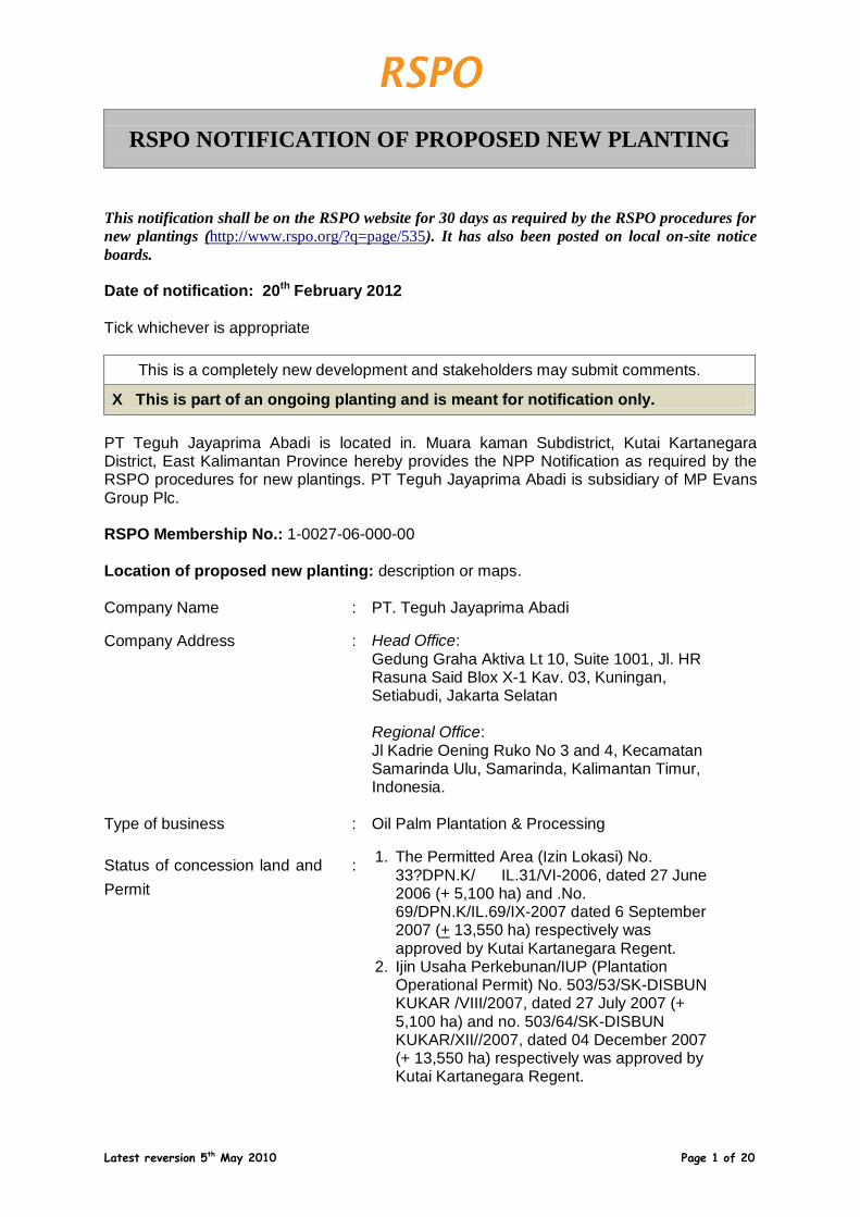
Latest reversion 5 th May 2010 Page 1 of 20 RSPO NOTIFICATION OF PROPOSED NEW PLANTING This notification shall be on the RSPO website for 30 days as required by the RSPO procedures for new plantings (http://www.rspo.org/?q=page/535 ). It has also been posted on local on-site notice boards. Date of notification: 20 th February 2012 Tick whichever is appropriate This is a completely new development and stakeholders may submit comments. X This is part of an ongoing planting and is meant for notification only. PT Teguh Jayaprima Abadi is located in. Muara kaman Subdistrict, Kutai Kartanegara District, East Kalimantan Province hereby provides the NPP Notification as required by the RSPO procedures for new plantings. PT Teguh Jayaprima Abadi is subsidiary of MP Evans Group Plc. RSPO Membership No.: 1-0027-06-000-00 Location of proposed new planting: description or maps. Company Name : PT. Teguh Jayaprima Abadi Company Address : Head Office: Gedung Graha Aktiva Lt 10, Suite 1001, Jl. HR Rasuna Said Blox X-1 Kav. 03, Kuningan, Setiabudi, Jakarta Selatan Regional Office: Jl Kadrie Oening Ruko No 3 and 4, Kecamatan Samarinda Ulu, Samarinda, Kalimantan Timur, Indonesia. Type of business : Oil Palm Plantation & Processing Status of concession land and Permit : 1. The Permitted Area (Izin Lokasi) No. 33?DPN.K/ IL.31/VI-2006, dated 27 June 2006 (+ 5,100 ha) and .No. 69/DPN.K/IL.69/IX-2007 dated 6 September 2007 (+ 13,550 ha) respectively was approved by Kutai Kartanegara Regent. 2. Ijin Usaha Perkebunan/IUP (Plantation Operational Permit) No. 503/53/SK-DISBUN KUKAR /VIII/2007, dated 27 July 2007 (+ 5,100 ha) and no. 503/64/SK-DISBUN KUKAR/XII//2007, dated 04 December 2007 (+ 13,550 ha) respectively was approved by Kutai Kartanegara Regent.
Transcript of RSPO NOTIFICATION OF PROPOSED NEW PLANTING RSPO NOTIFICATION OF... · “Hasil Hutan Non-Kayu dalam...
Latest reversion 5th May 2010 Page 1 of 20
RSPO NOTIFICATION OF PROPOSED NEW PLANTING
This notification shall be on the RSPO website for 30 days as required by the RSPO procedures for
new plantings (http://www.rspo.org/?q=page/535). It has also been posted on local on-site notice
boards.
Date of notification: 20th February 2012 Tick whichever is appropriate
This is a completely new development and stakeholders may submit comments.
X This is part of an ongoing planting and is meant for notification only.
PT Teguh Jayaprima Abadi is located in. Muara kaman Subdistrict, Kutai Kartanegara District, East Kalimantan Province hereby provides the NPP Notification as required by the RSPO procedures for new plantings. PT Teguh Jayaprima Abadi is subsidiary of MP Evans Group Plc. RSPO Membership No.: 1-0027-06-000-00 Location of proposed new planting: description or maps. Company Name : PT. Teguh Jayaprima Abadi
Company Address : Head Office: Gedung Graha Aktiva Lt 10, Suite 1001, Jl. HR Rasuna Said Blox X-1 Kav. 03, Kuningan, Setiabudi, Jakarta Selatan Regional Office: Jl Kadrie Oening Ruko No 3 and 4, Kecamatan Samarinda Ulu, Samarinda, Kalimantan Timur, Indonesia.
Type of business : Oil Palm Plantation & Processing
Status of concession land and
Permit
: 1. The Permitted Area (Izin Lokasi) No.
33?DPN.K/ IL.31/VI-2006, dated 27 June 2006 (+ 5,100 ha) and .No. 69/DPN.K/IL.69/IX-2007 dated 6 September 2007 (+ 13,550 ha) respectively was approved by Kutai Kartanegara Regent.
2. Ijin Usaha Perkebunan/IUP (Plantation
Operational Permit) No. 503/53/SK-DISBUN KUKAR /VIII/2007, dated 27 July 2007 (+ 5,100 ha) and no. 503/64/SK-DISBUN KUKAR/XII//2007, dated 04 December 2007 (+ 13,550 ha) respectively was approved by Kutai Kartanegara Regent.
Latest reversion 5th May 2010 Page 2 of 20
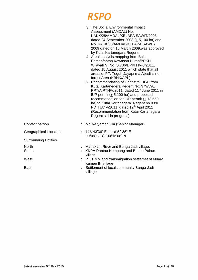
3. The Social Environmental Impact
Assessment (AMDAL) No. KAKK/28/AMDAL/KELAPA SAWIT/2008, dated 24 September 2008 (+ 5,100 ha) and No. KAKK/08/AMDAL/KELAPA SAWIT/ 2009 dated on 16 March 2009.was approved by Kutai Kartanegara Regent.
4. Areal analysis mapping from Balai
Pemanfaatan Kawasan Hutan/BPKH Wilayah VI No. S.736/BPKH IV-3/2011, dated 15 August 2011 which state that all areas of PT. Teguh Jayaprima Abadi is non forest Area (KBNK/APL)
5. Recommendation of Cadastral HGU from
Kutai Kartanegera Regent No. 379/590/ PPT/A.PTN/V/2011, dated 11th June 2011 in IUP permit (+ 5.100 ha) and proposed recommendation for IUP permit (+ 13,550 ha) to Kutai Kartanegara Regent no.039/ PD TJA/IV/2011, dated 12th April 2011 (Recommendation from Kutai Kartanegara Regent still in progress)
Contact person : Mr. Veryaman Hia (Senior Manager)
Geographical Location : 116o43’36” E - 116o52’35” E 00o09’17” S -00o15’06” N
Surrounding Entities
North : Mahakam River and Bunga Jadi village.
South : KKPA Rantau Hempang and Benua Puhun village
West : PT. PMM and transmigration settlemet of Muara Kaman Ilir village
East : Settlement of local community Bunga Jadi villlage

Latest reversion 5th May 2010 Page 3 of 20
Picture 1. Location of PT Teguh Jayaprima Abadi in East Kalimantan Province
Picture 2. Location of PT. Teguh Jayaprima Abadi in Kutai Kartanegara District.
Latest reversion 5th May 2010 Page 4 of 20
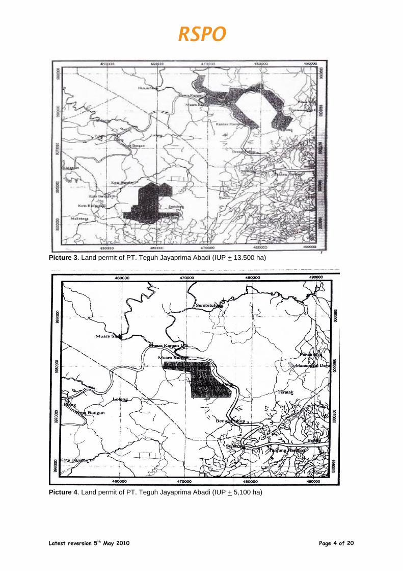
Picture 3. Land permit of PT. Teguh Jayaprima Abadi (IUP + 13.500 ha)
Picture 4. Land permit of PT. Teguh Jayaprima Abadi (IUP + 5,100 ha)
Latest reversion 5th May 2010 Page 5 of 20
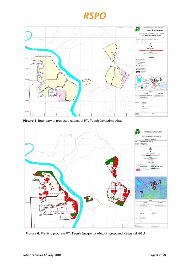
Picture 5. Boundary of proposed cadastral PT. Teguh Jayaprima Abadi
Picture 6. Planting program PT. Teguh Jayaprima Abadi in proposed Kadastral HGU
Latest reversion 5th May 2010 Page 6 of 20
SUMMARY FROM SEIA ASSESSMENTS:
Assessors and their credentials: The Social Impact Assessment of PT TJA was carried out on 17 – 24 June 2012 by Aksenta which is located at Jl. Gandaria VIII/10, Kebayoran Baru, Jakarta 12130; Telephone/fax: +62 21 739-6518, E-mail: [email protected]. The key consultants conducting these
assessments have been accredited and approved by RSPO. The team members are:
1. Gelar Satya Budhi, He graduated Master of Science in Community Development from
University of Putra Malaysia. He is senior researcher on social economic and community development aspect, which is some commodities are plantation, food plants, horticulture, ranch and forestry. Ever collaborated in research of applied research and participatory action research with some national institution (Bappenas, Bank Indonesia Pusat, Bank Indonesia Bandung, Kementerian Pertanian, Pemda DKI, IPB, Unpad) either or international (ICRAF, CIFOR, IFPRI, ACIAR, JBIC, ESCAP, IDRC). Active writing an article on some journals in Indonesian language and English about some topics, which is published by PSE-KP, UI and some universities. In teens articles release in some mass media like Kompas, Suara Pembaruan, Bisnis Indonesia, Suara Karya and Pikiran Rakyat. Conveying working paper on some seminars in Indonesia or abroad, like under one’s belt by Asian Productivity Organization (APO). Some writes from his research published on book Improving Smallholder Farming Systems in Imperata Areas of Southeast Asia published with International. Since 2007 – 2009 become member of eight teams to help research of Agriculture Ministry. Now Gelar Satya Budhi engage in some Social Impact Assessment (SIA) and HCV activitiy in social and culture sector in Aksenta. His role in this Social Impact Assessment is as a Team Leader.
2. Muayat Ali Muhshi ([email protected]), He graduated from the Faculty of Forestry
Graduated from Bogor Agricultural University (IPB) – Bogor majoring in Forest Resources Conservation. He is experienced as a reseracher at WALHI and as a member of Book Editor “Peran HPH dalam Pembangunan Ekonomi Regional Kaltim” (Walhi and World Resources Institute, 1990-1991). He is also experienced as a Forestry Program Coordinator in Pelangi Indonesia Foundation and doing a studi: “Integrasi Bina Desa dalam Kerangka Pengelolaan KPHP” supported by ODA – in cooperation with Ministry of Forestry – UK Tropical Forestry Management Program; and the study of “Hasil Hutan Non-Kayu dalam Rangka Pengelolaan Hutan Berbasis Masyarakat” supported by NOVIB – the Netherlands (1991-1997). And also he worked in many roles for many years. His role in this Social Impact Assessment is as a team member.
3. Nandang Mulyana ([email protected]), He graduated from the Faculty of
Agriculture Graduated from UMJ (Jakarta Muhammadiyah University) – Jakarta majoring in Economics and a Master Degree holder from Bogor Agriculture University. He is experienced in the field of education, environment, socio-environment, and community development programme (CDCSR), collaborated with Unocal Geothermal of Indonesia Ltd and Chevron Geothermal Salak since 2000. Nandang Mulyana wrote a book on “Membedah UMKM di Indonesia; Sebuah Kajian tentang Strategi Pemberdayaan dan Pengembangan UMKM Indonesia” published by Lugas. He has
conducted several HCV and Social Impact Assessments in oil palm plantations in Indonesia with Aksenta. In year 2010. achieved the RSPO accreditation as Discipline Specialist Social (Participatory rural assessment; socioeconomic or cultural studies; participatory mapping; conflict resolution). His role in this Social Impact Assessment is as The Team member focus on social economic and community development assessment. Companies
Latest reversion 5th May 2010 Page 7 of 20
Assessment Methods (data sources, collection, dates, program, and visited places) SEIA assessment Methods
SEIA assessment was conducted by Aksenta in Desa Rantau Hempang and Bunga Jadi during the same time as the HCV assessment. SEIA activities were carried out over a period of 8 days from 17th to 24th June 2012 by the team consisting of Erizal, Gelar S. Budhi, Mimin Aminah, Miranty Magetsari, Muayat Ali Muhshi, and Nandang Mulyana. Assessments were conducted by field observations, interviews, FGD (Focus Group Discussion) and document reviews. Stages of the SIA assessment included: 1. Social rapid Assessment 2. Document reviews 3. Participatory mapping Data collection method included: 1. Primary and secondary data reviews 2. Dialogues 3. Field Observations 4. Indepth Interviews 5. Triangulation The methods used to analyze the social impacts and risks were qualitative using the tools of sustainable livelihood, RSPO Principles and Criteria, FPIC principles, national laws and regulations, and other applicable standards. Public consultation was conducted on 22th June 2012 to obtain feedback from the findings of HCV and SEIA from various interested parties. Inputs from the public consultation are documented as evidence in the Final HCV and SEIA reports. The Public Consultation was attended by Aksenta, PT Teguh Jayaprima Abadi employee, leaders of cooperatives (KKPA), community leaders, traditional leaders, village chiefs, district representatives, and government agencies.
Summary of SEIA Findings a positive impact on the livelihoods of the surrounding villagers who also viewed the activities of the company favorably. Some of the positive impacts were: 1. Palm oil development has utilized land that had been abandoned. 2. Palm oil development also increases various job opportunities for local people including
women and elderly people. 3. Palm oil development and the KKPA scheme has enabled the villagers to gain
employment, have a steady source of income and subsequently will enhance the economic potential of the villagers.
4. Palm oil development has created a positive social impact whereby relationship among the villagers is now more harmonious than previously.
5. With opening of estate roads, children from the desas have better access for schooling and people in general have better access to economic opportunities, education and health care.
Latest reversion 5th May 2010 Page 8 of 20
Strategic issues highlighted in the study include : 1. There is concern of environmental pollution of rivers and reduction in traditional fishing
area. 2. CSR activities need to be increase and improve. 3. The lack of facilities such as workers housing, schools, clinics and electricity supply which
is limited. 4. Although most of employees are permanent (SKU) and contracted (PKWT) workers
(SKU) there is still some workers engaged on temporary system (BHL).. 5. Some areas in the “Proposed Kadastral Area” overlap with “Izin” for Mining Companies
and this has to be resolved amicably. Village boundaries have not been verified by the authorities.
SUMMARY FROM HCV ASSESSMENT(S):
Assessors and their credentials The HCV assessment in the Proposed cadastral of HGU PT. Teguh Jayaprima Abadi by the RSP0 accredited assessors. The HCV assessment conducted from 15th – 24th June 2012 in the proposed cadastral of HGU and villagges surrounding area was carried by Aksenta, located at Jl. Gandaria VIII/10, Kebayoran Baru, Jakarta 12130; Telephone/fax: +62 21 739-6518, E-mail: [email protected]. Key consultants from Aksenta have been accredited and approved by RSPO. The team members are: 1. Pupung F. Nurwatha ([email protected]), Biology Scholar from Padjajaran
University, Bandung. Get training about Fieldwork Techniques for Conservational Expeditions on year 2002 in London, UK. Experienced in wildlife research since 1990, expertise in Community Based on Biodiversity Assessment and managing a wildlife conservationist grouping in Bandung. HCV assessment studies in plantations sector and registered in RSPO Accredited HCV Assessor – Discipline Specialist in HCV 1, 2, and 3 Biodiversity and Conservation
2. Idung Risdiyanto ([email protected]), Master degree in Environmental
Management technology in International Program of Bogor Agricultural University (IPB), after he graduated from undergraduate degree of Applied Meteorology in Mathematic and Natural Science Faculty of Bogor Agriculture University (IPB). He started carrier with doing a research about Green House Gasses and water resources together with UNEP and PPLH IPB at 1997. Else, he did many researchs with good institutions, such as LIPI, LAPAN, BPPT, and BMKG. Almost his entire work related to the natural resources management especially water resources, land and climate using GIS technology, remote sensing, spatial analysis and modelling. He is experianced for doing HCV assessment in plantation sector and also already registered as a RSPO Approved HCV assessor – discipline specialist with specialization HCV 4 (Hydrology and Environmental Services.
3. Gena Lysistrata ([email protected]), she graduated from social science in
Faculty of Social Science, University of Indonesia. She is a researcher and involve actively in to various social research, and experienced in to community empowerment programmes, family strengthen, and evaluating the community participatory. She started her involvement as a SIA assessor in Aksenta since 2010 and already registered as an approved HCV assessor in RSPO for discipline specialist with specialization HCV 5 and HCV 6.
Latest reversion 5th May 2010 Page 9 of 20
4. Diah Rany P. Swasti ([email protected]), she graduated from Faculty of
Forestry, Bogor Agricultural University (IPB). She is still involve actively in to various activities related to the research of forestry issues and experienced in GIS and remote sensing. She did various studies related to the fussion technique of pankromatik image spot, for this HCV assessment of PT TJA, she is involved as a GIS team member in Aksenta.
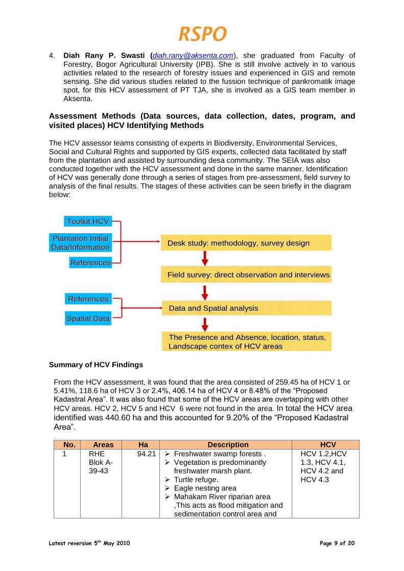
Assessment Methods (Data sources, data collection, dates, program, and visited places) HCV Identifying Methods The HCV assessor teams consisting of experts in Biodiversity, Environmental Services, Social and Cultural Rights and supported by GIS experts, collected data facilitated by staff from the plantation and assisted by surrounding desa community. The SEIA was also conducted together with the HCV assessment and done in the same manner. Identification of HCV was generally done through a series of stages from pre-assessment, field survey to analysis of the final results. The stages of these activities can be seen briefly in the diagram below:
Toolkit HCVToolkit HCV
Plantation Initial Plantation Initial
Data/Information Data/Information
ReferencesReferences
Desk study: methodology, survey design Desk study: methodology, survey design
Field survey: direct observation and interviewsField survey: direct observation and interviews
Data and Spatial analysis Data and Spatial analysis
The Presence and Absence, location, status, The Presence and Absence, location, status,
Landscape Landscape contexcontex of HCV areasof HCV areas
Spatial DataSpatial Data
ReferencesReferences
Summary of HCV Findings
From the HCV assessment, it was found that the area consisted of 259.45 ha of HCV 1 or 5.41%, 118.6 ha of HCV 3 or 2.4%, 406.14 ha of HCV 4 or 8.48% of the “Proposed Kadastral Area”. It was also found that some of the HCV areas are overlapping with other
HCV areas. HCV 2, HCV 5 and HCV 6 were not found in the area. In total the HCV area identified was 440.60 ha and this accounted for 9.20% of the “Proposed Kadastral Area”.
No. Areas Ha Description HCV
1 RHE Blok A-39-43
94.21 Freshwater swamp forests . Vegetation is predominantly
freshwater marsh plant. Turtle refuge. Eagle nesting area Mahakam River riparian area
,This acts as flood mitigation and sedimentation control area and
HCV 1.2,HCV 1.3, HCV 4.1, HCV 4.2 and HCV 4.3
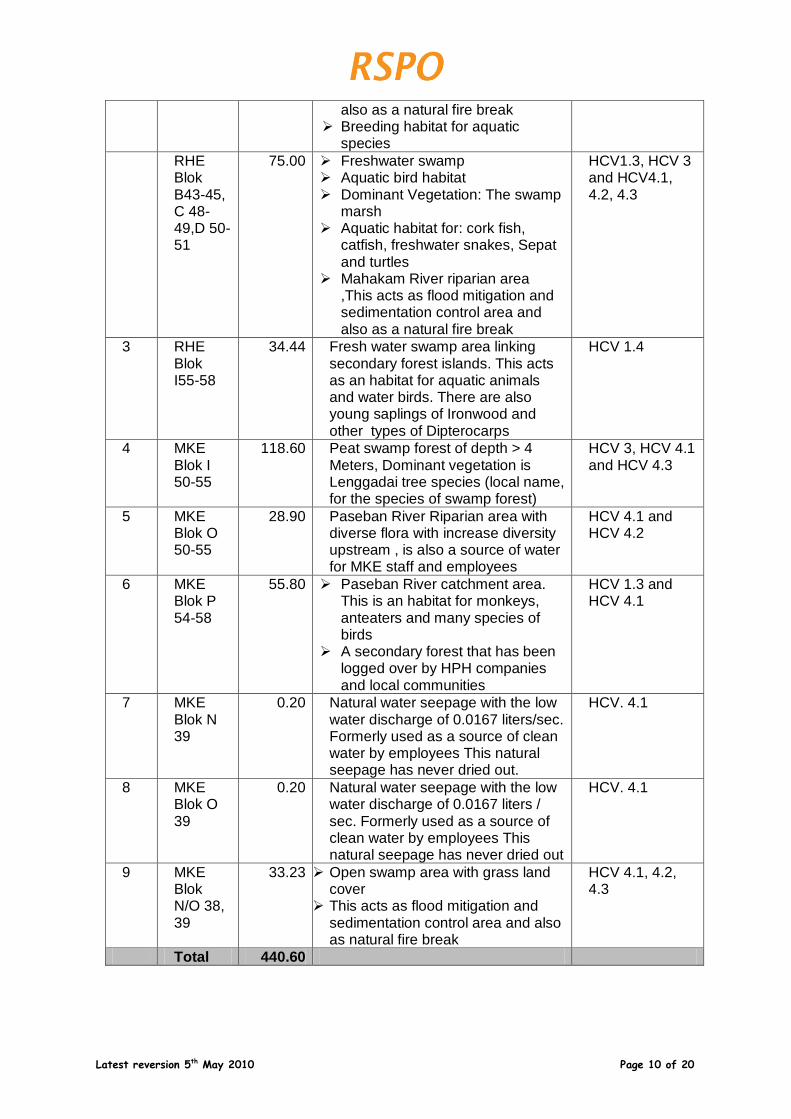
Latest reversion 5th May 2010 Page 10 of 20
also as a natural fire break Breeding habitat for aquatic
species
RHE Blok B43-45, C 48-49,D 50-51
75.00 Freshwater swamp Aquatic bird habitat Dominant Vegetation: The swamp
marsh Aquatic habitat for: cork fish,
catfish, freshwater snakes, Sepat and turtles
Mahakam River riparian area ,This acts as flood mitigation and sedimentation control area and also as a natural fire break
HCV1.3, HCV 3 and HCV4.1, 4.2, 4.3
3 RHE Blok I55-58
34.44 Fresh water swamp area linking secondary forest islands. This acts as an habitat for aquatic animals and water birds. There are also young saplings of Ironwood and other types of Dipterocarps
HCV 1.4
4 MKE Blok I 50-55
118.60 Peat swamp forest of depth > 4 Meters, Dominant vegetation is Lenggadai tree species (local name, for the species of swamp forest)
HCV 3, HCV 4.1 and HCV 4.3
5 MKE Blok O 50-55
28.90 Paseban River Riparian area with diverse flora with increase diversity upstream , is also a source of water for MKE staff and employees
HCV 4.1 and HCV 4.2
6 MKE Blok P 54-58
55.80 Paseban River catchment area. This is an habitat for monkeys, anteaters and many species of birds
A secondary forest that has been logged over by HPH companies and local communities
HCV 1.3 and HCV 4.1
7 MKE Blok N 39
0.20 Natural water seepage with the low water discharge of 0.0167 liters/sec. Formerly used as a source of clean water by employees This natural seepage has never dried out.
HCV. 4.1
8 MKE Blok O 39
0.20 Natural water seepage with the low water discharge of 0.0167 liters / sec. Formerly used as a source of clean water by employees This natural seepage has never dried out
HCV. 4.1
9 MKE Blok N/O 38, 39
33.23 Open swamp area with grass land cover
This acts as flood mitigation and sedimentation control area and also as natural fire break
HCV 4.1, 4.2, 4.3
Total 440.60
Latest reversion 5th May 2010 Page 11 of 20
SUMMARY OF PLANs:
Development of HCV and SIA Management Plans
PT Teguh Jayaprima Abadi received licenses (Izin Lokasi) to use land areas of + 5,100 ha and + 13,500 Ha through SK Bupati Kutai Kartanegara No. 33/DPN.K/IL.31/ VI-2006 dated June 2006 and SK Bupati Kutai Kartanegara No 69/DPN.K/IL.69/IX-2007 dated September 2007 respectively PT Teguh Jayaprima Abadii has conducted a review of the environmental and social factors highlighted in the EIA document that has been verified by the government through SK Bupati Kutai Kartanegara No. KAKK/08/AMDAL/KELAPA SAWIT/2009 and KAKK/28/AMDAL/KELAPA SAWIT/2008 dated 24 September 2008. .The Plantation Operational Permit (Izin Usaha Perkebunan,/IUP) for both these Izin Lokasi were obtained through SK Bupati Kutai Kartanegara no. 503/53/SK-DISBUN KUKAR /VIII/2007, dated 27 July 2007 and no. 503/64/SK-DISBUN KUKAR/XII//2007, dated 04 December 2007 respectively was approved by Bupati Kutai Kartanegara. . The findings on both the HCV and SIA have been incorporated in the oil palm development plan of PT Teguh Jayaprima Abadi which includes the HCV and SIA management and monitoring plans of PT. Teguh Jayaprima Abadi. The results of the assessment and the management plans are documented and presented and discussed in a stakeholders’ consultation on 22th June 2012 in PT. TJA’s office. The feedback from this stakeholders’ consultation have also been incorporated into the oil palm development plan as well as the HCV and SIA management plan. The implementation of the HCV and SIA management & monitoring plans in the field will be implemented by experienced personnel who possessed a high level of dedication of knowledge and special technical skills. RSPO team, Pemitra/Scheme Manager and support by D & L Dept. (Document and Legal) stationed at the location, will provide support in these activities. The Estate Manager is directly responsible on the implementation of the plans of management and monitoring.. The Head of Operation Agronomy is accountable and responsible to ensure that the Overall Development Plan including the management of HCV and SIA is implemented according to the time plan and budget. The management team is supported and supervised by the President Director.
Stakeholders to be involved’ The Stakeholders’ Consultation was held on 22th June 2012 in PT. TJA’s office (List of attendance stkaholders meeting in appendix. 1) to provide opportunities for communication and sharing the informations/opinion/suggestions. This is also part of the process of free, prior and informed consent procedures to ensure that there is a balance in the social and environmental harmony in the development of the oil palm planting project between PT. Teguh Jayaprima Abadi and the stakeholders. The summary of the consultation with highlights of key suggestions from the consultation on HCV, SIA, and RSPO P&C are as follow: 1. Is there any important area for flora and fauna?
Head of village: Mahakam estate, Orang Utan still exist, perhaps because they had a boundary with industrial wood concession (HTI) Tanjung Karas, also because in those concession area there are exist the community land which is still forest cover.
Latest reversion 5th May 2010 Page 12 of 20
Rantau hempang and Muara Kaman Hilir found many Dutch Monkey and Orang Utan. But, it seems that they are influenced by the reducing of HCV because the mining activities.
Rantau hempang, there are still many of wildlife, however at recent days they are rare to be found.
For protection area, it depends on the local government regulation whether giving a permit for mining or not.
PT TJA concession area already worked on. The wildlife disappeared after an issuance of PT TJA concession area.
It is good to be recommended to the local government, that there are a conservation area in this area, so that no license could be issued to the mining company.
After doing this study and to be reported if the company ruled to open the land of PT PMM and PT TJA, what will happenning next?
Head of cooperation (KPPA): What is the differenciacies between public consultation of EIA and HCV? Why it’s done after the land opening already done? Whereas if this public consultation were done before the opening land, many areas will be saved.
BLHD: Community involved to arrange the documents of EIA, there are a rules said the company should reseved 10% from the concession area. Basically those two activities are related each other. An EIA documents arrangement involving many stakeholders.
Dishutbun (Forest and Plantation Agency): Does on the studies of Aksenta already considered a several things related to the issues that the company permit were overlaid with mining company and when the company operated their activities, what will be doing by the company? And whether this studies already considered the periodic swamp and permanent swamp around the concession area?
Head of Loleng Village: There are conservation forest that already reseved. And we are talking about the continuity of wildlife. From the management is should be better if prioritized an important person in the field, so that the management were doing the monitoring in accordance to the inside-plantation-activities, and as a community we know that it is important to had a cooperation.
Cooperation head: Commonly in this forest, there are many fruits can be found and also many kinds of wood can be found. As a community, we are inviting the company management for doing an enrichment again an existing conservation area.
2. Is there still any an important water resources?
Sumelis river
There is a mill located at the upstream of Sumelis river.
Ishak: Bukit Jering, there is a well/water resource which is entered by the hand, we can feel an electricity (already confirmed by the field team of HCV assessment)/
3. Is there any an important places for the continuity of local cultural identities?
No, there aren’t. The HCV assessment team didn’t find any places to become a cultural identity. It is already confirmed by the visiting of HCV assessment team.
SIA Management and Mitigation Plan PT Teguh Jayaprima Abadi has developed the plans for the conservation impacts and social impacts as the operational efforts on social and conservation mitigation. The SIA development and preparation of management & monitoring plans was mainly based on the SIA Assessment result administered in 17th – 24th June 2012, in corporate with the Aksenta; consultant accredited and approved by RSPO and the Social Environment Impact Assessment (AMDAL) was approved by Kutai Kartenagara Regent, No. KAKK/28/AMDAL/KELAPA SAWIT/2008, dated 24 September 2008 (5,100 ha) and No.
Latest reversion 5th May 2010 Page 13 of 20
KAKK/08/AMDAL/KELAPA SAWIT/2009 dated on 16st March 2009, in principle, referred to the related laws in Indonesia. Summary of SEIA Management and Mitigation Plan as follows:
No.
Description Management Objective
Action Plan PIC Target
1 Land acquisition by Company
To ensure that the land acquisition process is in accordance with the principles of FPIC
Resocialization of SOPs on Land acquisition
Manager D&L
01-2013
2 KKPA Cooperatives
Fostering integrity and accountability in the KKPA Cooperatives
Conduct education and training to Management representatives and members of Cooperatives .
Assisting and guiding Cooperative management representatives in making transparent and credible financial statements.
Continuously supervising Cooperatives to conduct Annual General Meetings of members as scheduled and required by law.
Engaging with the Department of Cooperatives to supervise the AGMs and monitoring the Cooperatives activities and the relevant reports needed to be submitted to the various Authorities
Pemitra/ Scheme Manager Pemitra/ Scheme Manager Pemitra/ Scheme Manager Pemitra/ Scheme Manager
2013 Continual Continual Continual
3 CSR Programs
Prepare CSR programs according to the needs of the surrounding communities within the financial capabilities of the Company
Conduct consultations with local government and community leaders on the needs of the villages.
Estate Manager
2013

Latest reversion 5th May 2010 Page 14 of 20
4 Internal issues
Develop programs to improve Occupational Health and Safety (OSH) for employees • Develop programs to improve the welfare of employees
Develop understanding and cooperation with the nearest Health Care Clinics
Budgeting and planning for the construction of clinics in the estates
Provide and improve creche
Improve transportation facilities for schoolchildren
2012 2013 2012 2012
HCV Management and Mitigation Plan The HCV development and preparation of management & monitoring plans was based on the result of the HCV assessment which was administered in 15th – 24th March 2012 by independent consultants from Aksenta who has been accredited and approved by RSPO. The HCV development and preparation of management & monitoring plans was implemented with the aim to provide guideline for the company in planning and management of its programs or activities in managing the HCV present within the concession area. Summary of HCV Management and Mitigation Plan as follows:
No.
HCV Area
Ha HCV Criteria
Management Program Target
1 RHE Blok A-39-43
94.21 HCV1.2, HCV 1.3, HCV 4.1, HCV 4.2 and HCV 4.3
Purpose:
To Protection of biodiversity/ conservation area.
Objective:
To protect and maintain the buffers around the streams
Program: Management and monitoring action of HCV Area
Method:
Delineation of HCV areas on site according to results of HCV identification
Conducting patrolling and monitoring of the conservation areas
Socialization to staff, employees and the public on the presence of HCV and inform what actions are permitted and prohibited in the conservation areas
Construction and improvement of signboards and notice boards/ warning signage around the HCV areas
Improving the quality of the habitat in the conservation areas through enrichment by planting appropriate forest plants.
Ensure that conservation areas identified are not mistakenly cleared for planting
Conduct fire patrols during dry seasons
2012 2012 and continual 2012 2013 2012 and continual continual continual
Latest reversion 5th May 2010 Page 15 of 20
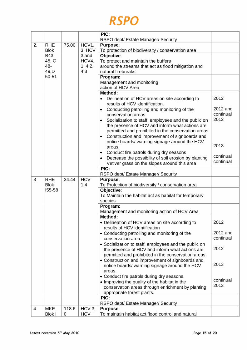
PIC: RSPO dept/ Estate Manager/ Security
2. RHE Blok B43-45, C 48-49,D 50-51
75.00 HCV1.3, HCV 3 and HCV4.1, 4.2, 4.3
Purpose: To protection of biodiversity / conservation area
Objective: To protect and maintain the buffers around the streams that act as flood mitigation and natural firebreaks
Program:
Management and monitoring action of HCV Area
Method:
Delineation of HCV areas on site according to results of HCV identification.
Conducting patrolling and monitoring of the conservation areas
Socialization to staff, employees and the public on the presence of HCV and inform what actions are permitted and prohibited in the conservation areas
Construction and improvement of signboards and notice boards/ warning signage around the HCV areas.
Conduct fire patrols during dry seasons
Decrease the possibility of soil erosion by planting Vetiver grass on the slopes around this area
2012 2012 and continual 2012 2013 continual continual
PIC: RSPO dept/ Estate Manager/ Security
3 RHE Blok I55-58
34.44 HCV 1.4
Purpose: To Protection of biodiversity / conservation area
Objective: To Maintain the habitat act as habitat for temporary species
Program: Management and monitoring action of HCV Area
Method:
Delineation of HCV areas on site according to results of HCV identification
Conducting patrolling and monitoring of the conservation area.
Socialization to staff, employees and the public on the presence of HCV and inform what actions are permitted and prohibited in the conservation areas.
Construction and improvement of signboards and notice boards/ warning signage around the HCV areas.
Conduct fire patrols during dry seasons.
Improving the quality of the habitat in the conservation areas through enrichment by planting appropriate forest plants.
2012 2012 and continual 2012 2013 continual 2013
PIC:
RSPO dept/ Estate Manager/ Security
4 MKE Blok I
118.60
HCV 3, HCV
Purpose:
To maintain habitat act flood control and natural
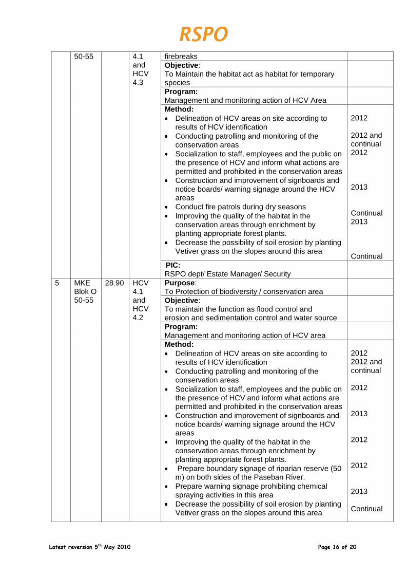
Latest reversion 5th May 2010 Page 16 of 20
50-55
4.1 and HCV 4.3
firebreaks
Objective: To Maintain the habitat act as habitat for temporary species
Program: Management and monitoring action of HCV Area
Method:
Delineation of HCV areas on site according to results of HCV identification
Conducting patrolling and monitoring of the conservation areas
Socialization to staff, employees and the public on the presence of HCV and inform what actions are permitted and prohibited in the conservation areas
Construction and improvement of signboards and notice boards/ warning signage around the HCV areas
Conduct fire patrols during dry seasons
Improving the quality of the habitat in the conservation areas through enrichment by planting appropriate forest plants.
Decrease the possibility of soil erosion by planting Vetiver grass on the slopes around this area
2012 2012 and continual 2012 2013 Continual 2013 Continual
PIC: RSPO dept/ Estate Manager/ Security
5 MKE Blok O 50-55
28.90 HCV 4.1 and HCV 4.2
Purpose: To Protection of biodiversity / conservation area
Objective: To maintain the function as flood control and erosion and sedimentation control and water source
Program: Management and monitoring action of HCV area
Method:
Delineation of HCV areas on site according to results of HCV identification
Conducting patrolling and monitoring of the conservation areas
Socialization to staff, employees and the public on the presence of HCV and inform what actions are permitted and prohibited in the conservation areas
Construction and improvement of signboards and notice boards/ warning signage around the HCV areas
Improving the quality of the habitat in the conservation areas through enrichment by planting appropriate forest plants.
Prepare boundary signage of riparian reserve (50 m) on both sides of the Paseban River.
Prepare warning signage prohibiting chemical spraying activities in this area
Decrease the possibility of soil erosion by planting Vetiver grass on the slopes around this area
2012 2012 and continual 2012 2013 2012 2012 2013 Continual

Latest reversion 5th May 2010 Page 17 of 20
PIC: RSPO dept/ Estate Manager/ Security
6 MKE Blok P 54-58
55.80 HCV 1.3 and HCV 4.1
Purpose: To Protection of biodiversity / conservation area
Objective: To Maintain the function of area as a habitat for the spesies with limited distribution and as water resources
Program:
Management and monitoring action of HCV Area
Method:
Delineation of HCV areas on site according to results of HCV identification
Conducting patrolling and monitoring of the conservation areas
Socialization to staff, employees and the public on the presence of HCV and inform what actions are permitted and prohibited in the conservation areas
Construction and improvement of signboards and notice boards/ warning signage around the HCV areas
Improving the quality of the habitat in the conservation areas through enrichment by planting appropriate forest plant
Prepare boundary signage of riparian reserve (50 m) on both sides of the Paseban River.
Prepare warning signage prohibiting chemical spraying activities in this area
Decrease the possibility of soil erosion by planting Vetiver grass on the slopes around this area
2012 2012 and continual 2012 2013 2012 2012 2013 Continual
PIC: RSPO dept/ Estate Manager/ Security
7 MKE Blok N 39
0.20 HCV. 4.1
Purpose: To Protection of biodiversity / conservation area
Objective: To Maintain the function of area as the water resources
Program:
Management and monitoring action of HCV Area
Method:
Delineation of HCV areas on site according to results of HCV identification
Conducting patrolling and monitoring of the conservation areas
Socialization to staff, employees and the public on the presence of HCV and inform what actions are permitted and prohibited in the conservation areas
Construction and improvement of signboards and notice boards/ warning signage around the HCV areas
Improving the quality of the habitat in the conservation areas through enrichment by planting
2012 2012 and continual 2012 2013 2013
Latest reversion 5th May 2010 Page 18 of 20
appropriate forest plants..
PIC: RSPO dept/ Estate Manager/ Security
8 MKE Blok O 39
0.20 HCV. 4.1
Purpose: To Protection of biodiversity / conservation area
Objective: To Maintain the function of area as the water resources
Program: Management and monitoring action of HCV Area
Method:
Delineation of HCV areas on site according to results of HCV identification
Conducting patrolling and monitoring of the conservation areas
Socialization to staff, employees and the public on the presence of HCV and inform what actions are permitted and prohibited in the conservation areas
Construction and improvement of signboards and notice boards/ warning signage around the HCV areas
Improving the quality of the habitat in the conservation areas through enrichment by planting appropriate forest plants
2012 2012 and continual 2012 2013 2013
PIC: RSPO dept/ Estate Manager/ Security
9 MKE Blok N/O 38, 39
33.23 HCV 4.1, 4.2, 4.3
Purpose: To Protection of biodiversity / conservation area
Objective: To maintain the function as flood control and natural firebreaks
Program:
Management and monitoring action of HCV Area
Method:
Delineation of HCV areas on site according to results of HCV identification
Conducting patrolling and monitoring of the conservation areas
Socialization to staff, employees and the public on the presence of HCV and inform what actions are permitted and prohibited in the conservation areas
Construction and improvement of signboards and notice boards/ warning signage around the HCV areas
Conduct fire patrols during dry seasons
Improving the quality of the habitat in the conservation areas through enrichment by planting appropriate forest plants.
2012 2012 and continual 2012 2013 Continual 2013
PIC: RSPO dept/ Estate Manager/ Security
Total 440.6
Latest reversion 5th May 2010 Page 19 of 20
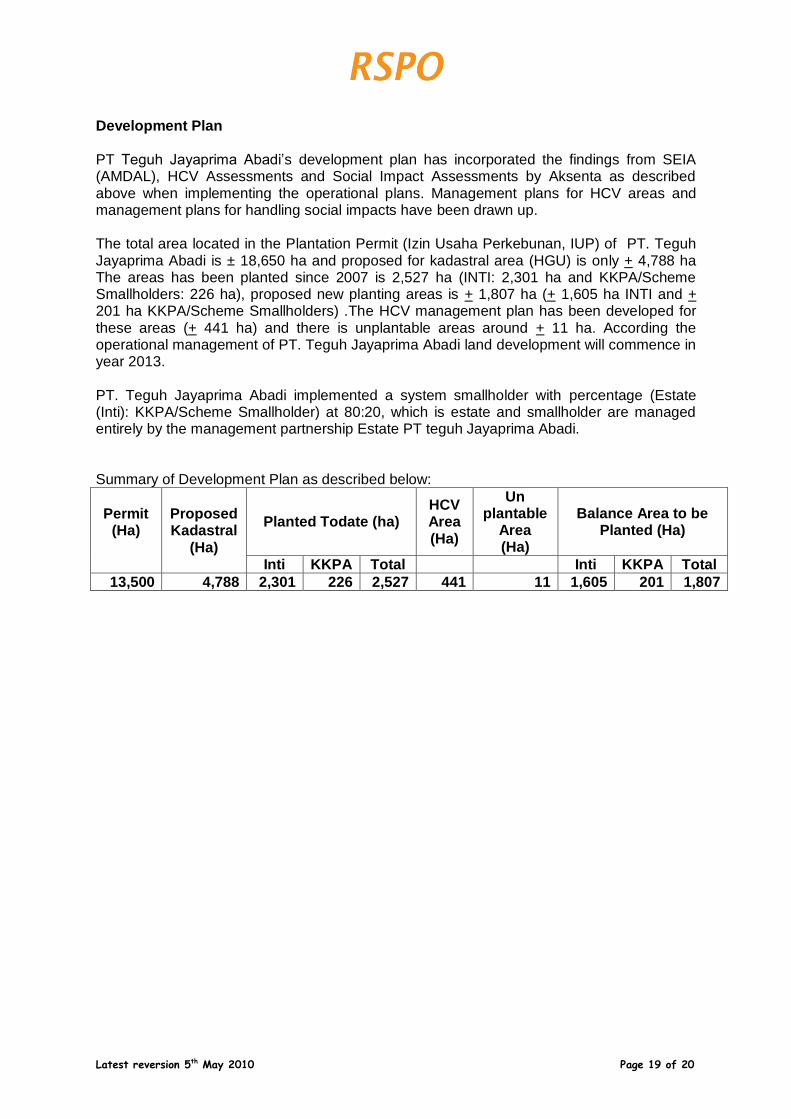
Development Plan PT Teguh Jayaprima Abadi’s development plan has incorporated the findings from SEIA (AMDAL), HCV Assessments and Social Impact Assessments by Aksenta as described above when implementing the operational plans. Management plans for HCV areas and management plans for handling social impacts have been drawn up. The total area located in the Plantation Permit (Izin Usaha Perkebunan, IUP) of PT. Teguh Jayaprima Abadi is ± 18,650 ha and proposed for kadastral area (HGU) is only + 4,788 ha The areas has been planted since 2007 is 2,527 ha (INTI: 2,301 ha and KKPA/Scheme Smallholders: 226 ha), proposed new planting areas is + 1,807 ha (+ 1,605 ha INTI and + 201 ha KKPA/Scheme Smallholders) .The HCV management plan has been developed for these areas (+ 441 ha) and there is unplantable areas around + 11 ha. According the operational management of PT. Teguh Jayaprima Abadi land development will commence in year 2013. PT. Teguh Jayaprima Abadi implemented a system smallholder with percentage (Estate (Inti): KKPA/Scheme Smallholder) at 80:20, which is estate and smallholder are managed entirely by the management partnership Estate PT teguh Jayaprima Abadi. Summary of Development Plan as described below:
Permit (Ha)
Proposed Kadastral
(Ha)
Planted Todate (ha) HCV Area (Ha)
Un plantable
Area (Ha)
Balance Area to be Planted (Ha)
Inti KKPA Total Inti KKPA Total
13,500 4,788 2,301 226 2,527 441 11 1,605 201 1,807
Latest reversion 5th May 2010 Page 20 of 20
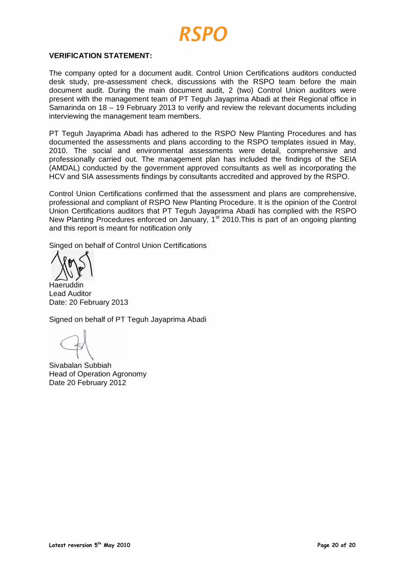
VERIFICATION STATEMENT:
The company opted for a document audit. Control Union Certifications auditors conducted desk study, pre-assessment check, discussions with the RSPO team before the main document audit. During the main document audit, 2 (two) Control Union auditors were present with the management team of PT Teguh Jayaprima Abadi at their Regional office in Samarinda on 18 – 19 February 2013 to verify and review the relevant documents including interviewing the management team members. PT Teguh Jayaprima Abadi has adhered to the RSPO New Planting Procedures and has documented the assessments and plans according to the RSPO templates issued in May, 2010. The social and environmental assessments were detail, comprehensive and professionally carried out. The management plan has included the findings of the SEIA (AMDAL) conducted by the government approved consultants as well as incorporating the HCV and SIA assessments findings by consultants accredited and approved by the RSPO. Control Union Certifications confirmed that the assessment and plans are comprehensive, professional and compliant of RSPO New Planting Procedure. It is the opinion of the Control Union Certifications auditors that PT Teguh Jayaprima Abadi has complied with the RSPO New Planting Procedures enforced on January, 1st 2010.This is part of an ongoing planting and this report is meant for notification only Singed on behalf of Control Union Certifications
Haeruddin Lead Auditor Date: 20 February 2013 Signed on behalf of PT Teguh Jayaprima Abadi
Sivabalan Subbiah Head of Operation Agronomy Date 20 February 2012