RSPO New Planting Procedures Summary Report of · PDF fileRSPO New Planting Procedures Summary...
25
NPP Summary of SEIA & HCV Assessments for Olam International Ltd May 2012 1 RSPO New Planting Procedures Summary Report of SEIA and HCV Assessments 1. Executive Summary Olam Palm Gabon, a subsidiary of Olam International, and the Government of the Republic of Gabon have partnered in a 70:30 Joint Venture to develop industrial and smallholder oil palm plantations and processing facilities in Gabon over two phases. The development is part of new national policies aiming to eradicate poverty and implement structural reforms to diversify sources of growth. The palm oil produced will be sold in both local and international markets. In September 2011, Olam Palm was granted a 35,354 ha concession located in Ngounié Province (the “Mouila concession”), for agro-industrial oil palm plantation development. Olam Palm commissioned a High Conservation Value assessment and Social & Environmental Impact assessment (SEIA). The SEIA and HCV assessments were completed to identify the potential impacts on the environment and communities and to subsequently support the definition of the geographical area where the actual project will be implemented, after excluding all high conservation value and riparian areas. Additionally, Olam Palm Gabon has engaged communities to obtain their free, prior and informed consent. Assessment of Forest Areas The forest inventory from 72 plots recorded 9,444 trees (>10cm dbh) grouped into 264 species from 56 families dominated by Caesalpiniaceae, Burseraceae, Euphorbiaceae, Olacaceae and Ebenaceae. The dominant species overall is Okoumé (Aucoumea klaineana) which is highly typical of disturbed or secondary forests as is Rikio (Uapaca guineensis) but other dominant species are typical of flooded forests (e.g. Hymenostegia sp.) or more mature forests (e.g. Strombosiopsis sp., Diospyros sp.). The terra firma forests are composed of a complex mixture of young, degraded or old secondary forests, but do not represent ‘primary forest’ as it is understood in Gabon i.e. large expanses of ‘ancient forests’. Seasonally flooded forests show the fewest signs of anthropogenic disturbance in this landscape, and have the most interesting flora from a conservation perspective. They are characterised by a strong dominance of an unknown Hymenostegia sp. and Assongho (Anthostema aubyranum), as well as the strong presence of two Cynometra species (one of which is also unknown). Seasonally flooded forests are considered HCV 3. Areas required to maintain or enhance one of more HCV Areas supporting HCV 1.2, 1.3, 3, 4.1, 5 & 6 were identified during the HCV assessment. These areas are further discussed below. Peat soils There are no peat soils within the project area, evidenced by the soil and agronomic studies. The soils encountered on the project site fall within three classes: ferralitic soils, hydromorphic soils, which are soils are in sinkholes and drainage axes, soils on simple slopes or the tops of hills where the terrain increases slightly. In addition there are a few spots of podzolic soil. All these soils are closely interwoven, forming a mosaic directly related to the topography. Local peoples’ lands (addressed in HCV 5 & 6) Local peoples’ lands were identified through social participatory mapping. This process identified both the areas currently used for hunting, fishing and collection of forest products, but also sacred and culturally important sites. Preliminary maps produced through this process will be refined through the FPIC process. Identification of areas important to local communities was completed in two phases. The first phase, involved a socio-economic survey of each village potentially impacted by the project. In the second step, a team of IRET experts completed participatory mapping in each village.
Transcript of RSPO New Planting Procedures Summary Report of · PDF fileRSPO New Planting Procedures Summary...
NPP Summary of SEIA & HCV Assessments for Olam International Ltd May 2012 1
RSPO New Planting Procedures Summary Report of SEIA and HCV Assessments
1. Executive Summary
Olam Palm Gabon, a subsidiary of Olam International, and the Government of the Republic of Gabon have partnered in a 70:30 Joint Venture to develop industrial and smallholder oil palm plantations and processing facilities in Gabon over two phases. The development is part of new national policies aiming to eradicate poverty and implement structural reforms to diversify sources of growth. The palm oil produced will be sold in both local and international markets.
In September 2011, Olam Palm was granted a 35,354 ha concession located in Ngounié Province (the “Mouila concession”), for agro-industrial oil palm plantation development. Olam Palm commissioned a High Conservation Value assessment and Social & Environmental Impact assessment (SEIA). The SEIA and HCV assessments were completed to identify the potential impacts on the environment and communities and to subsequently support the definition of the geographical area where the actual project will be implemented, after excluding all high conservation value and riparian areas. Additionally, Olam Palm Gabon has engaged communities to obtain their free, prior and informed consent.
Assessment of Forest Areas The forest inventory from 72 plots recorded 9,444 trees (>10cm dbh) grouped into 264 species from 56 families dominated by Caesalpiniaceae, Burseraceae, Euphorbiaceae, Olacaceae and Ebenaceae. The dominant species overall is Okoumé (Aucoumea klaineana) which is highly typical of disturbed or secondary forests as is Rikio (Uapaca guineensis) but other dominant species are typical of flooded forests (e.g. Hymenostegia sp.) or more mature forests (e.g. Strombosiopsis sp., Diospyros sp.). The terra firma forests are composed of a complex mixture of young, degraded or old secondary forests, but do not represent ‘primary forest’ as it is understood in Gabon i.e. large expanses of ‘ancient forests’. Seasonally flooded forests show the fewest signs of anthropogenic disturbance in this landscape, and have the most interesting flora from a conservation perspective. They are characterised by a strong dominance of an unknown Hymenostegia sp. and Assongho (Anthostema aubyranum), as well as the strong presence of two Cynometra species (one of which is also unknown). Seasonally flooded forests are considered HCV 3.
Areas required to maintain or enhance one of more HCV Areas supporting HCV 1.2, 1.3, 3, 4.1, 5 & 6 were identified during the HCV assessment. These areas are further discussed below.
Peat soils There are no peat soils within the project area, evidenced by the soil and agronomic studies.
The soils encountered on the project site fall within three classes: ferralitic soils, hydromorphic soils, which are soils are in sinkholes and drainage axes, soils on simple slopes or the tops of hills where the terrain increases slightly. In addition there are a few spots of podzolic soil. All these soils are closely interwoven, forming a mosaic directly related to the topography.
Local peoples’ lands (addressed in HCV 5 & 6)
Local peoples’ lands were identified through social participatory mapping. This process identified both the areas currently used for hunting, fishing and collection of forest products, but also sacred and culturally important sites. Preliminary maps produced through this process will be refined through the FPIC process.
Identification of areas important to local communities was completed in two phases. The first phase, involved a socio-economic survey of each village potentially impacted by the project. In the second step, a team of IRET experts completed participatory mapping in each village.

2 NPP Summary of SEIA & HCV Assessments for Olam International Ltd May 2012
Village Activities and resources within the Mouila concession HCV
5
HCV
6
Moudouma No overlap with Olam concession Abs Abs
Douya Virtually no overlap with the Olam concession Abs Abs
Guiamba Several overlapping activities, sacred sites, old villages, lakes. Fishing,
hunting and gathering and some old agricultural fallows located in the
concession area.
Pres Pres
Mutame Sane
Fumu
Overlaps with active agricultural fields and fallows, old villages, lakes, sacred
sites, hunting and gathering activities.
Pres Pres
Doubou 5 old villages, cemeteries, lakes, hunting and fishing camps, gathering.
Expressed concern over having adequate buffer zone between concession
and village.
Pres Pres
Mboukou Fields and fallows, 10 old villages, 3 sacred sites, 2 cemeteries, hunting,
fishing, gathering activities
Pres Pres
Ditounga 1 sacred site, lake, camp, hunting and fishing Pres Pres
Rembo 3 camps, 1 old village, lakes, hunting, fishing and gathering. Expressed
concern over having adequate buffer zone between concession and village
Pres Pres
Guidouma Low impact – a few fishing and hunting activities within the concession. Poss Poss
St. Martin Located on the other side of the river, some hunting, fishing and gathering
activities within the concession
Pres Poss
Migabe Located on the other side of the river, some hunting, fishing and gathering
activities within the concession
Pres Poss
Ningui not impacted – far from concession limits. HCV 5 & 6 absent. Abs Abs
NPP Summary of SEIA & HCV Assessments for Olam International Ltd May 2012 3
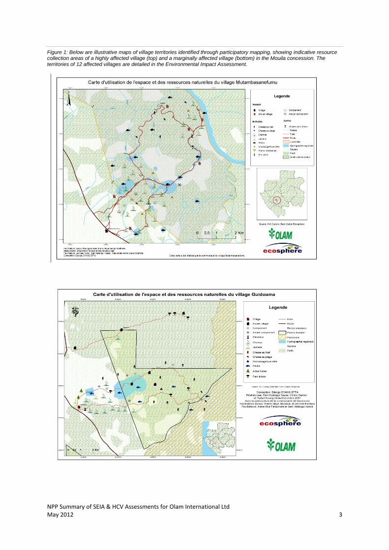
Figure 1: Below are illustrative maps of village territories identified through participatory mapping, showing indicative resource collection areas of a highly affected village (top) and a marginally affected village (bottom) in the Mouila concession. The territories of 12 affected villages are detailed in the Environmental Impact Assessment.
NPP Summary of SEIA & HCV Assessments for Olam International Ltd May 2012 4
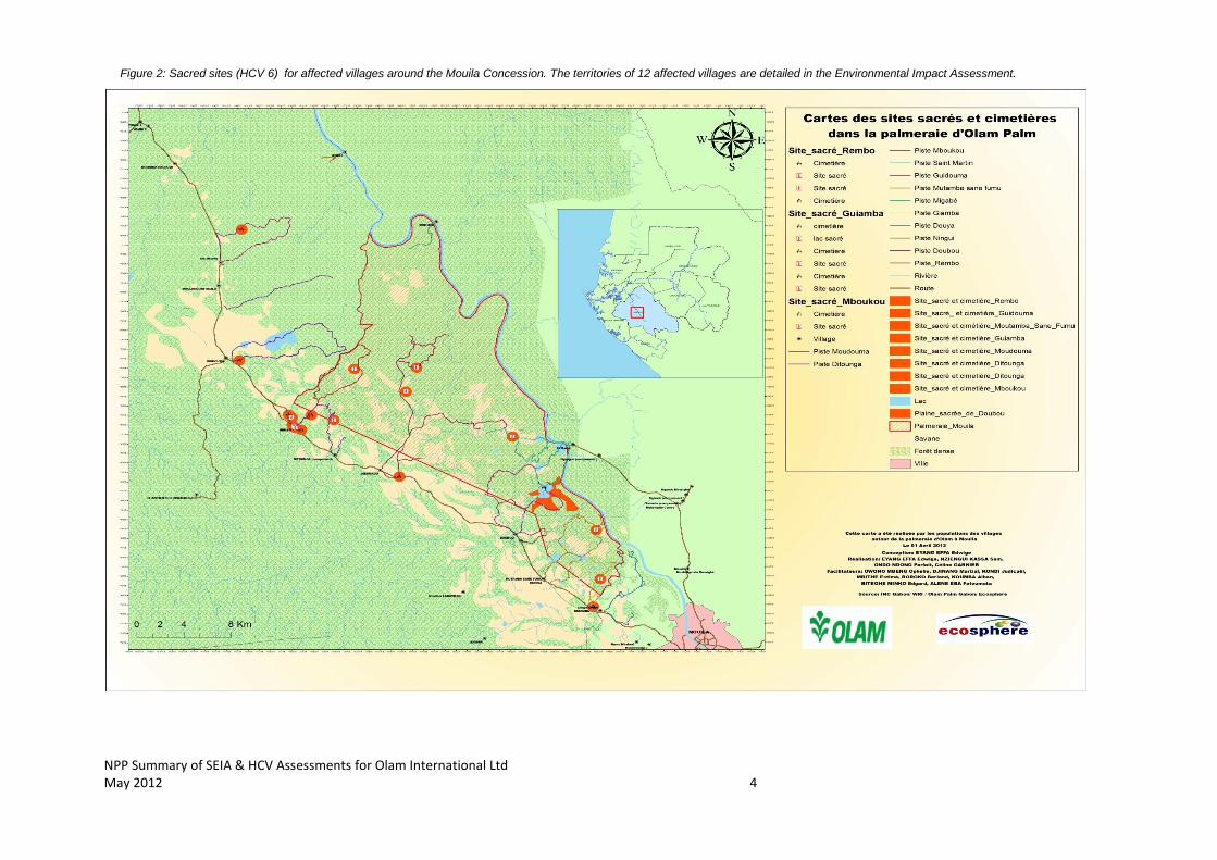
Figure 2: Sacred sites (HCV 6) for affected villages around the Mouila Concession. The territories of 12 affected villages are detailed in the Environmental Impact Assessment.

NPP Summary of SEIA & HCV Assessments for Olam International Ltd May 2012 5
2. Scope of The SEIA and HCV Assessment
Organisational information and contact persons Olam Palm engaged Ecosphere SARL
1, a Gabonese environmental consultancy, and Proforest (UK)
2,
to respectively conduct an SEIA and HCV assessment of a 35,354 ha concession north of Mouila between September 2011 and March 2012.
Name Role and Institution Expertise
Proforest: High Conservation Value Assessment
Christopher STEWART Proforest, RSPO Lead Assessor
Biodiversity/ conservation expertise
Ellen BROWN Proforest Socio-economic and participatory rural assessment expertise
Ecosphere: Social and Environmental Impact Assessment
Victor BOUMONO MOUKOUMI,
Michelle Sylvana TSIOBA MOUBOUALI,
Gerly EKOTY
Ecosphere SEIA coordinators
Legal documents, regulatory permits and property deeds related to the areas assessed
Concession agreement for long-term lease between the Government of Gabon (GoG), represented by the Prime Minister, and Olam Palm Gabon: This agreement summarizes the rights and obligations of Olam Palm Gabon on the acquisition of a concession north of Mouila with a total area of 35,354 ha (period of 50 years, renewable once) to be developed for oil palm.
Decision No. 141/11 of 18 October 2011: Authorization issued to Olam Palm Gabon by the Ministry of Water and Forestry for conducting surveys in forest concessions covering an area of 35,354 ha, up to one year, to determine the feasibility of agro-industrial plantations.
DGEF-Ordnance - November 2010 Cartographic Project for Olam Palm Gabon: These documents define the site boundaries of Mouila concession awarded to Olam Palm Gabon by the Convention on the grant of long leases.
Location maps and description The Mouila concession covers 35,354 ha northwest of the town of Mouila in Ngounié Province, approximately 440 km southeast of Libreville, and is located in the forest-savannah transition region of southern Gabon. It is on a gently undulating plain over limestone/shale bedrock, yielding soils of moderate to low fertility (including small, highly infertile patches and areas of hard pan and concretions); however, most soils are suitable for palm plantations according to soil analyses commissioned by OLAM, with fertiliser additions as required for economic yields. Located on the left bank of the Ngounié River, the concession is in the catchment of three minor rivers: Rembo, Doubou and Douya, which have their source in the Tandou mountains of the Mayombe massif to the west and flow in the direction southwest - northeast emptying into the Ngounié. These rivers flow through the concession area for 21.7 km (Rembo), 8.3 km (Doubou) and 9.4 km (Douya) respectively. The concession is delimited by the Ngounié River in the North, the Rembo in the NE and the Douya in the SW. There are also smaller permanent water courses in the south eastern section of the concession, most notably the Douguehy River.
The savannah areas in the concession are irregular in shape and range from a few dozen meters wide to open plains a kilometre or so across. They may be linked together or entirely surrounded by
1 ECOSOPHERE SARL, Quartier Montagne Sainte, Libreville, Gabon
2 www.proforest.net
6 NPP Summary of SEIA & HCV Assessments for Olam International Ltd May 2012
trees. Drier savannah areas are characterised by grasses or sedges whist the shallow cockpits3 have
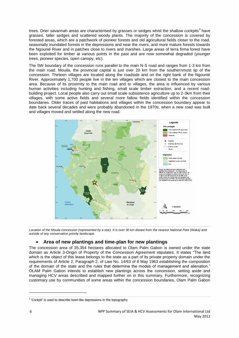
grasses, taller sedges and scattered woody plants. The majority of the concession is covered by forested areas, which are a patchwork of pioneer forests and old agricultural fields closer to the road, seasonally inundated forests in the depressions and near the rivers, and more mature forests towards the Ngounié River and in patches close to rivers and marshes. Large areas of terra firma forest have been exploited for timber at various points in the past and are now somewhat degraded (younger trees, pioneer species, open canopy, etc).
The SW boundary of the concession runs parallel to the main N-S road and ranges from 1-3 km from the main road. Mouila, the provincial capital is just over 20 km from the southernmost tip of the concession. Thirteen villages are located along the roadside and on the right bank of the Ngounié River. Approximately 1,700 people live in the ten villages which are closest to the main concession area. Because of its proximity to the main road and to villages, the area is influenced by various human activities including hunting and fishing, small scale timber extraction, and a recent road-building project. Local people also carry out small scale subsistence agriculture up to 2-3km from their villages, with some active fields and several more fallow fields identified within the concession boundaries. Older traces of past habitations and villages within the concession boundary appear to date back several decades and were probably abandoned in the 1970s, when a new road was built and villages moved and settled along the new road.
Location of the Mouila concession (represented by a star). It is over 30 km distant from the nearest National Park (Waka) and outside of any conservation priority landscape.
Area of new plantings and time-plan for new plantings The concession area of 35,354 hectares allocated to Olam Palm Gabon is owned under the state domain as Article 3-Origin of Property of the Concession Agreement stipulates. It states “The land which is the object of this lease belongs to the state as a part of its private property domain under the requirements of Article 2, Paragraph 2, of Law No. 14/63 of 8 May 1963 establishing the composition of the domain of the state and the rules that determine the modes of management and alienation.” OLAM Palm Gabon intends to establish new plantings across the concession, setting aside and managing HCV areas described and mapped further on in this summary. Furthermore, recognizing customary use by communities of some areas within the concession boundaries, Olam Palm Gabon
3 ‘Cockpit’ is used to describe bowl-like depressions in the topography
NPP Summary of SEIA & HCV Assessments for Olam International Ltd May 2012 7
will map these areas in a participatory manner with the relevant villages and either excise or indemnify the appropriate parties as per agreement during the FPIC process.
Establishment of a nursery is underway and was described in a previous HCV report, which is available on the RSPO website. Commencement of planting is planned in the south of the site in the end of 2012, and further land clearance towards the Centre and Northern half of the concession will proceed in 2013 based on further modelling of the hydrological processes and detailed mapping of HCV areas (biological and social). Proforest has provided a detailed schedule and procedure to safeguard HCVs during land clearance operations.
NPP Summary of SEIA & HCV Assessments for Olam International Ltd May 2012 8
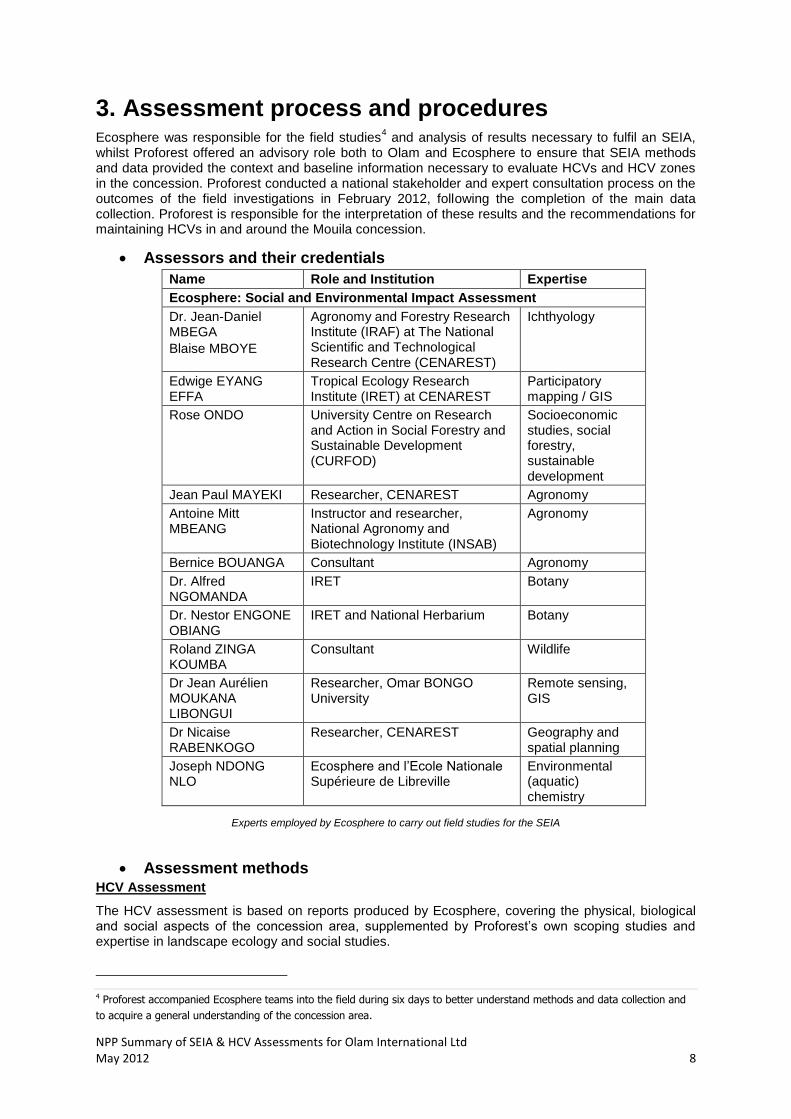
3. Assessment process and procedures Ecosphere was responsible for the field studies
4 and analysis of results necessary to fulfil an SEIA,
whilst Proforest offered an advisory role both to Olam and Ecosphere to ensure that SEIA methods and data provided the context and baseline information necessary to evaluate HCVs and HCV zones in the concession. Proforest conducted a national stakeholder and expert consultation process on the outcomes of the field investigations in February 2012, following the completion of the main data collection. Proforest is responsible for the interpretation of these results and the recommendations for maintaining HCVs in and around the Mouila concession.
Assessors and their credentials
Name Role and Institution Expertise
Ecosphere: Social and Environmental Impact Assessment
Dr. Jean-Daniel MBEGA
Blaise MBOYE
Agronomy and Forestry Research Institute (IRAF) at The National Scientific and Technological Research Centre (CENAREST)
Ichthyology
Edwige EYANG EFFA
Tropical Ecology Research Institute (IRET) at CENAREST
Participatory mapping / GIS
Rose ONDO University Centre on Research and Action in Social Forestry and Sustainable Development (CURFOD)
Socioeconomic studies, social forestry, sustainable development
Jean Paul MAYEKI Researcher, CENAREST Agronomy
Antoine Mitt MBEANG
Instructor and researcher, National Agronomy and Biotechnology Institute (INSAB)
Agronomy
Bernice BOUANGA Consultant Agronomy
Dr. Alfred NGOMANDA
IRET Botany
Dr. Nestor ENGONE OBIANG
IRET and National Herbarium Botany
Roland ZINGA KOUMBA
Consultant Wildlife
Dr Jean Aurélien MOUKANA LIBONGUI
Researcher, Omar BONGO University
Remote sensing, GIS
Dr Nicaise RABENKOGO
Researcher, CENAREST Geography and spatial planning
Joseph NDONG NLO
Ecosphere and l’Ecole Nationale Supérieure de Libreville
Environmental (aquatic) chemistry
Experts employed by Ecosphere to carry out field studies for the SEIA
Assessment methods HCV Assessment
The HCV assessment is based on reports produced by Ecosphere, covering the physical, biological and social aspects of the concession area, supplemented by Proforest’s own scoping studies and expertise in landscape ecology and social studies.
4 Proforest accompanied Ecosphere teams into the field during six days to better understand methods and data collection and
to acquire a general understanding of the concession area.

NPP Summary of SEIA & HCV Assessments for Olam International Ltd May 2012 9
Pre-assessment Methods comprised of a pre-assessment with desk-based research, a scoping visit and preliminary stakeholder consultation process, and field assessments to identify potential HCVs.
Scoping visits and main assessment Proforest and Ecosphere conducted scoping visits in September and October 2011. Several teams conducted field data collection between October 2011 and February 2012. Technical details are summarised in the next section.
Expert and national stakeholder consultations Proforest convened a meeting of the various SEIA team leaders and field technicians in February 2012, to collate results, compare opinions across different fields of expertise and to develop a preliminary interpretation of the HCVs present in the concession. Based on these results, Proforest then conducted consultations with national stakeholders and independent experts in February 2012.
Dates & Programme
Summary timetable of the SEIA and HCV assessment
SEIA Assessment
For this study, field missions were conducted by each Ecosphere expert to examine botany, ichthyology, agronomy, hydrology, soil science, entomology, carbon sequestration, socioeconomic factors, fauna and geophysics. Each field study was conducted through methodologies summarized below.
Data Collection
Agronomy: Several samples were taken in savanna areas using augers in addition to digging holes to examine the soil horizon. Additionally, the aim was to observe the different types of reliefs (slope, dune areas of congestion, etc.). Potential areas for implementation of the nursery were examined based on several criterions, such as: meeting nursery irrigation requirements of 750m
3 / d; proximity
to labor; topography; soil characteristics and lastly, the significance of risks posed by agricultural activity to the environment. Soil: Soil samples were taken along parallel transects oriented in a west-northeast direction, and depending on the slope of the terrain. A total of 24 survey areas were sampled. Morphological analysis was performed, taking into account the surrounding vegetation, and hydrography. Additionally, soil was modeled and characterized by its color, texture, structure, porosity, biological activity and the presence of coarse fragments in the soil profile. A physicochemical analysis was
No. Task Sept. 2011
Oct. 2011
Nov. 2011
Dec. 2011
Jan. 2012
Feb. 2012
Mar. 2012
1 HCV scoping visit
2 Initial field visits (botany, aquatic life, entomology)
3 First field data mission – nursery scoping
4 Second phase of field data collection – full SEIA
5 Socioeconomic surveys
6 Participatory mapping
7 Public consultation – Mouila concession
8 HCV national stakeholder consultations
9 Elaboration of SEIA and HCV reports
10 NPP Summary of SEIA & HCV Assessments for Olam International Ltd May 2012
carried out to determine the particle size. Further chemical analysis was limited to the determination of soil pH, exchangeable bases, exchangeable anions, calculation of the cationic exchange ratio (CEC) and carbon/nitrogen (C/N) ratio Flora: Botanical surveys of selected sites and a systematic forest inventory were conducted to characterise and evaluate vegetation types. Field data are cross-referenced with remote sensing data (canopy height and topography) obtained through a LIDAR survey at 1m precision. 72 plots of 0.5 ha placed every 500m along 7 transects were inventoried across the concession, representing ca. 0.2% of the total area.
Fauna: A literature survey was conducted to identify the faunal species which were potentially to be found in the concession, and to determine the conservation and protection status of the species encountered. A faunal survey was conducted along 8 transects ranging from 2-10 km long. Encounter rates for most species were low, and the data obtained are suitable for an analysis of relative encounter rates.
Aquatic biodiversity: Fish samples were collected from 20 sampling stations, across eight different streams covering a range of aquatic habitats. Fish were identified in situ, or preserved and sent to the national lab.
Hydrology: Major hydrological features were characterized according to size, depth, substrate and watershed. Width and depth of the streams and water velocity and flow rates were recorded. Water samples from 13 rivers and streams were analysed for temperature, pH, dissolved solids, dissolved oxygen, salinity and transparency. Water samples were submitted to comprehensive analysis as required by Gabonese law.
Socioeconomic surveys and participatory mapping: A socioeconomic survey was conducted in 12 villages surrounding the concession which included 106 household surveys and one group interview with community members in each of the survey villages. The survey questionnaire covered the following: household composition, educational level of family members, place of birth, activities of household members, household income, housing conditions, household goods and comfort, use of space and resources of the forest, and the project and development potential. Participatory mapping was conducted in 12 villages in order to identify economically and culturally important resources and sites for local communities. The social assessment process also included administrative and village meetings as required by law.
HCV interpretation: The HCV assessment consisted of literature reviews, scoping visits, continual support and an advisory role during the SEIA, HCV stakeholder consultations and SEIA evaluation and interpretation.
NPP Summary of SEIA & HCV Assessments for Olam International Ltd May 2012 11
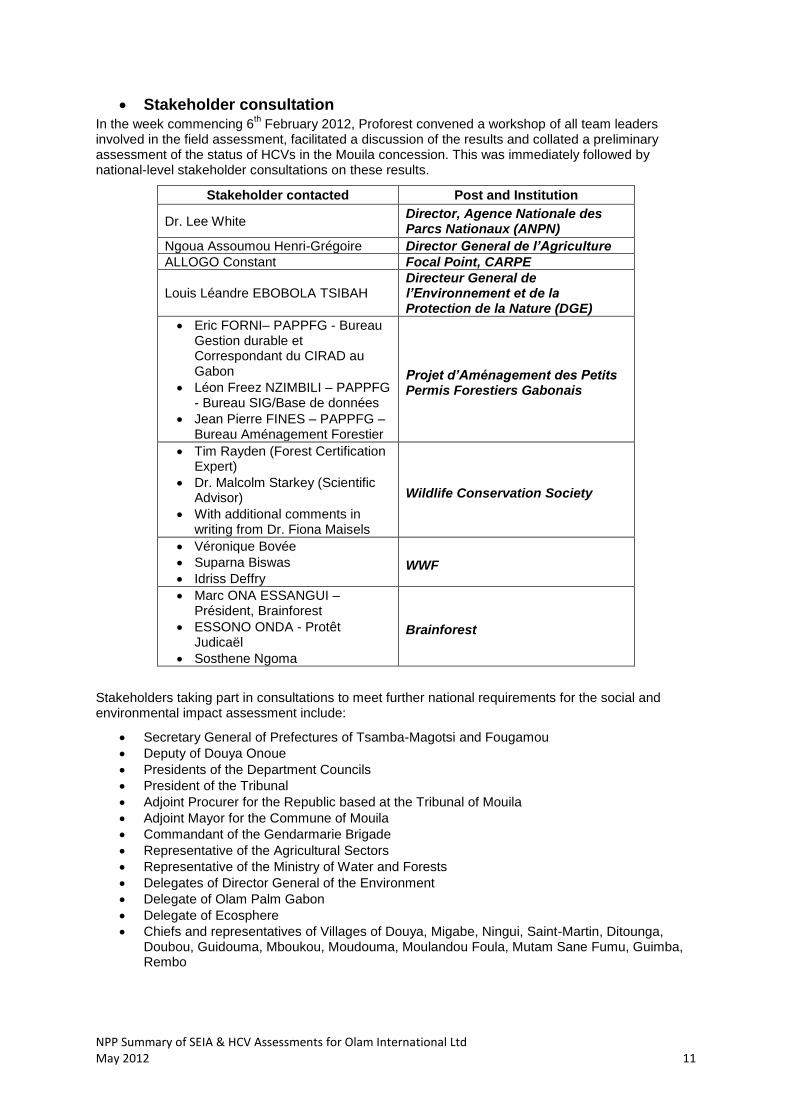
Stakeholder consultation In the week commencing 6
th February 2012, Proforest convened a workshop of all team leaders
involved in the field assessment, facilitated a discussion of the results and collated a preliminary assessment of the status of HCVs in the Mouila concession. This was immediately followed by national-level stakeholder consultations on these results.
Stakeholder contacted Post and Institution
Dr. Lee White Director, Agence Nationale des Parcs Nationaux (ANPN)
Ngoua Assoumou Henri-Grégoire Director General de l’Agriculture
ALLOGO Constant Focal Point, CARPE
Louis Léandre EBOBOLA TSIBAH Directeur General de l’Environnement et de la Protection de la Nature (DGE)
Eric FORNI– PAPPFG - Bureau Gestion durable et Correspondant du CIRAD au Gabon
Léon Freez NZIMBILI – PAPPFG - Bureau SIG/Base de données
Jean Pierre FINES – PAPPFG – Bureau Aménagement Forestier
Projet d’Aménagement des Petits Permis Forestiers Gabonais
Tim Rayden (Forest Certification Expert)
Dr. Malcolm Starkey (Scientific Advisor)
With additional comments in writing from Dr. Fiona Maisels
Wildlife Conservation Society
Véronique Bovée
Suparna Biswas
Idriss Deffry WWF
Marc ONA ESSANGUI – Président, Brainforest
ESSONO ONDA - Protêt Judicaël
Sosthene Ngoma
Brainforest
Stakeholders taking part in consultations to meet further national requirements for the social and environmental impact assessment include:
Secretary General of Prefectures of Tsamba-Magotsi and Fougamou
Deputy of Douya Onoue
Presidents of the Department Councils
President of the Tribunal
Adjoint Procurer for the Republic based at the Tribunal of Mouila
Adjoint Mayor for the Commune of Mouila
Commandant of the Gendarmarie Brigade
Representative of the Agricultural Sectors
Representative of the Ministry of Water and Forests
Delegates of Director General of the Environment
Delegate of Olam Palm Gabon
Delegate of Ecosphere
Chiefs and representatives of Villages of Douya, Migabe, Ningui, Saint-Martin, Ditounga, Doubou, Guidouma, Mboukou, Moudouma, Moulandou Foula, Mutam Sane Fumu, Guimba, Rembo
12 NPP Summary of SEIA & HCV Assessments for Olam International Ltd May 2012
List of Legal, regulatory and other guidance referenced
The laws applicable in the matter of environmental protection at the international level are: • The WTO Agreement on Sanitary and Phytosanitary Measures • The Convention on Biological Diversity (CBD) • The Cartagena Protocol on Biosafety • The Rotterdam Convention on Chemicals and Pesticides in International Trade • The Stockholm Convention on Persistent Organic Pollutants (POPs) • The Algiers Convention on the Conservation of Nature and Natural Resources • The Vienna Convention on the Protection of the Ozone Layer and the Montreal Protocol on substances that deplete the ozone layer • The United Nations Framework Convention on Climate Change (UNFCCC) • The Kyoto Protocol • The Convention on the Ban of the Import into Africa and the Obligation to Cooperate and Fight Against the Importation of Waste • The Basel Convention on the Control of Trans-boundary Movements of Hazardous Wastes and their Disposal
The following national laws governing the management and protection of the environment are applicable:
• The Constitution of the Gabonese Republic, which enshrines the right to own property and to a healthy environment; • Law No. 16/01 of December 31, 2001- Forestry Code in the Gabonese Republic • Decree No. 161/PR/MEF of 19 January 2011 laying down the conditions for issuing permits and licenses for hunting and capturing • Decree No. 162/PR/MEF of 19 January 2011 laying down detailed rules for the recognition and enforcement of certain offenses against water and forests • Decree No. 163/PR/MEF of 19 January 2011 laying down the conditions of detention, transportation and marketing of wild animals, trophies and hunting products • Decree No. 164 of 19 January 2011 regulating the classification and latitudes of slaughtering animals • Decree No. 679/PR/MEFCR of 28 July 1994 laying down the periods of opening and closing of hunting • Decree No. 115/PR/MAEFDR of 3 February 1981 on the protection of wildlife • Order No. 2043/PM/MEFPCEPN of 13 August 2003 prohibiting hunting, taking, possession, transportation and consumption of primates • Order No. 481/MEFPE of 14 August 1995 setting the dates of opening and closing of hunting • Law No. 22/2008 on Agricultural Code in the Gabonese Republic • Law No. 23/2008 on sustainable agricultural development policy • Law No. 16/93 26 August 1993 on the Protection and Improvement of the Environment and its implementing regulations that are:
-Decree No. 539/PR/MEFEPEPN of 15 July 2005, regulating the impact on the environment -Decree No. 541/PR/MEFEPEPN regulating waste disposal -Decree No. 542/PR/MEFEPEPN regulating the discharge of certain products in surface water, groundwater and marine -Decree No. 545/PR/MEFEPEPN regulating the recovery of waste oils; -Decree No. 653/PR/MTEPN on the preparation and the fight against pollution by oil and other harmful substances
• Order No. 2/PM/MEPNRT of 14 April 2006 laying down the procedures for issuing an authorization to perform impact studies on the environment • The Labour Code and Law No. 6/75, November 25, 1975 Carrying Code of Social Security • Law No. 6/61 of May 10, 1961 Regulating the expropriation for public utility easements and establishing for the execution of public works • Law No. 7/77 of 15 December 1977 on the establishment of a phytosanitary policy in the Gabonese Republic • Law No. 15/63 of 8 May 1963 establishing the regime of land ownership • Order 247/1996 of 12 March 1996 on mandatory regulations on imports for distribution and use of pesticides or plant protection
NPP Summary of SEIA & HCV Assessments for Olam International Ltd May 2012 13
• Order No. 2149/PM/MAEDRDHM, 30 November 2004 establishing a Committee on pesticide registration • The national implementation of the Stockholm Convention on Persistent Organic Pollutants in Gabon
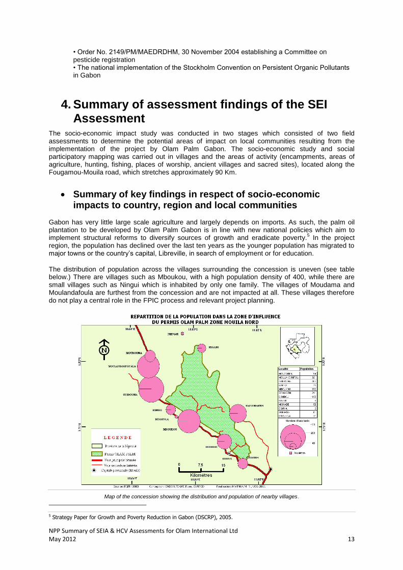
4. Summary of assessment findings of the SEI Assessment
The socio-economic impact study was conducted in two stages which consisted of two field assessments to determine the potential areas of impact on local communities resulting from the implementation of the project by Olam Palm Gabon. The socio-economic study and social participatory mapping was carried out in villages and the areas of activity (encampments, areas of agriculture, hunting, fishing, places of worship, ancient villages and sacred sites), located along the Fougamou-Mouila road, which stretches approximately 90 Km.
Summary of key findings in respect of socio-economic impacts to country, region and local communities
Gabon has very little large scale agriculture and largely depends on imports. As such, the palm oil plantation to be developed by Olam Palm Gabon is in line with new national policies which aim to implement structural reforms to diversify sources of growth and eradicate poverty.
5 In the project
region, the population has declined over the last ten years as the younger population has migrated to major towns or the country’s capital, Libreville, in search of employment or for education.
The distribution of population across the villages surrounding the concession is uneven (see table below.) There are villages such as Mboukou, with a high population density of 400, while there are small villages such as Ningui which is inhabited by only one family. The villages of Moudama and Moulandafoula are furthest from the concession and are not impacted at all. These villages therefore do not play a central role in the FPIC process and relevant project planning.
Map of the concession showing the distribution and population of nearby villages.
5 Strategy Paper for Growth and Poverty Reduction in Gabon (DSCRP), 2005.
14 NPP Summary of SEIA & HCV Assessments for Olam International Ltd May 2012
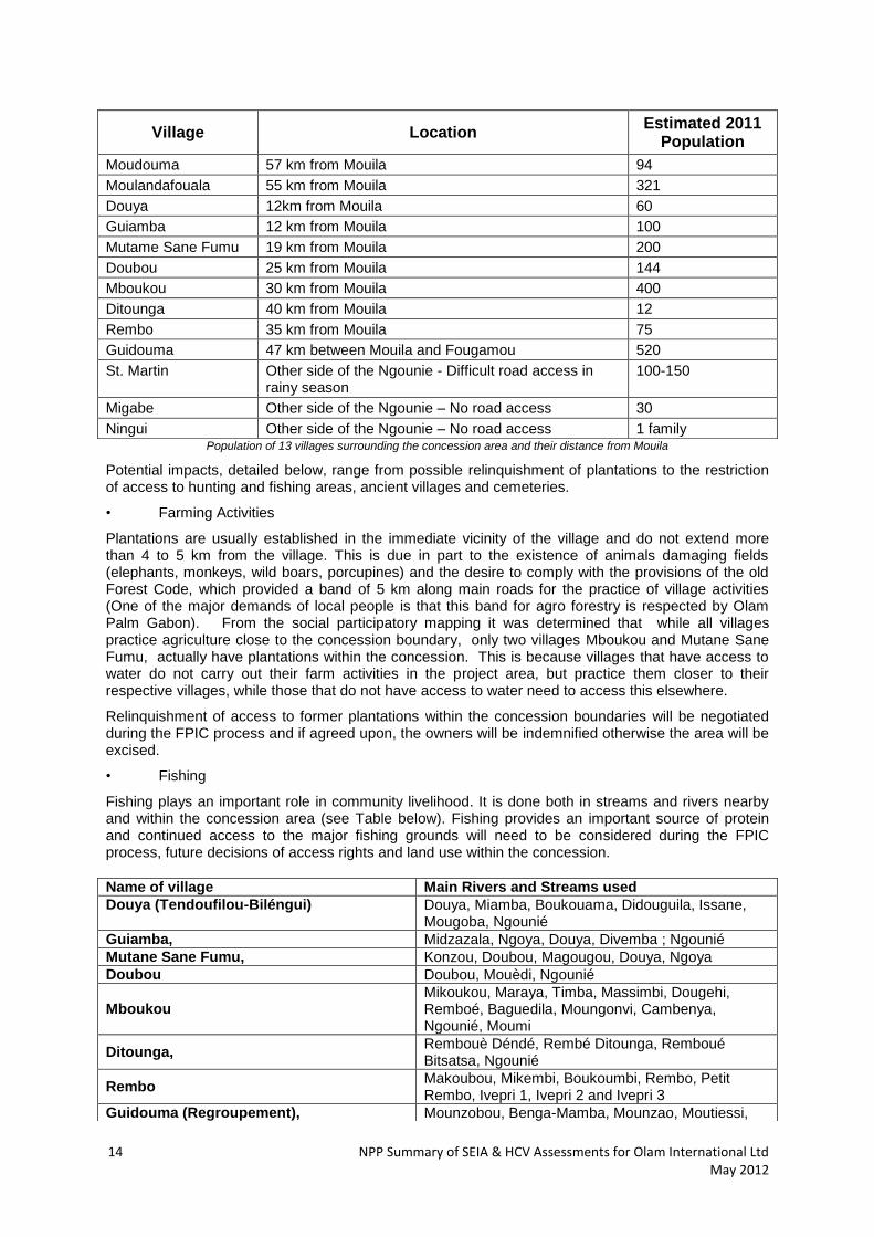
Population of 13 villages surrounding the concession area and their distance from Mouila
Potential impacts, detailed below, range from possible relinquishment of plantations to the restriction of access to hunting and fishing areas, ancient villages and cemeteries.
• Farming Activities
Plantations are usually established in the immediate vicinity of the village and do not extend more than 4 to 5 km from the village. This is due in part to the existence of animals damaging fields (elephants, monkeys, wild boars, porcupines) and the desire to comply with the provisions of the old Forest Code, which provided a band of 5 km along main roads for the practice of village activities (One of the major demands of local people is that this band for agro forestry is respected by Olam Palm Gabon). From the social participatory mapping it was determined that while all villages practice agriculture close to the concession boundary, only two villages Mboukou and Mutane Sane Fumu, actually have plantations within the concession. This is because villages that have access to water do not carry out their farm activities in the project area, but practice them closer to their respective villages, while those that do not have access to water need to access this elsewhere.
Relinquishment of access to former plantations within the concession boundaries will be negotiated during the FPIC process and if agreed upon, the owners will be indemnified otherwise the area will be excised.
• Fishing
Fishing plays an important role in community livelihood. It is done both in streams and rivers nearby and within the concession area (see Table below). Fishing provides an important source of protein and continued access to the major fishing grounds will need to be considered during the FPIC process, future decisions of access rights and land use within the concession.
Village Location Estimated 2011
Population
Moudouma 57 km from Mouila 94
Moulandafouala 55 km from Mouila 321
Douya 12km from Mouila 60
Guiamba 12 km from Mouila 100
Mutame Sane Fumu 19 km from Mouila 200
Doubou 25 km from Mouila 144
Mboukou 30 km from Mouila 400
Ditounga 40 km from Mouila 12
Rembo 35 km from Mouila 75
Guidouma 47 km between Mouila and Fougamou 520
St. Martin Other side of the Ngounie - Difficult road access in rainy season
100-150
Migabe Other side of the Ngounie – No road access 30
Ningui Other side of the Ngounie – No road access 1 family
Name of village Main Rivers and Streams used
Douya (Tendoufilou-Biléngui) Douya, Miamba, Boukouama, Didouguila, Issane, Mougoba, Ngounié
Guiamba, Midzazala, Ngoya, Douya, Divemba ; Ngounié
Mutane Sane Fumu, Konzou, Doubou, Magougou, Douya, Ngoya
Doubou Doubou, Mouèdi, Ngounié
Mboukou Mikoukou, Maraya, Timba, Massimbi, Dougehi, Remboé, Baguedila, Moungonvi, Cambenya, Ngounié, Moumi
Ditounga, Rembouè Déndé, Rembé Ditounga, Remboué Bitsatsa, Ngounié
Rembo Makoubou, Mikembi, Boukoumbi, Rembo, Petit Rembo, Ivepri 1, Ivepri 2 and Ivepri 3
Guidouma (Regroupement), Mounzobou, Benga-Mamba, Mounzao, Moutiessi,

NPP Summary of SEIA & HCV Assessments for Olam International Ltd May 2012 15
• Hunting
Hunting is presently practiced by most communities in much of the concession area. It begins in the vicinity of villages (small hunting) and gradually extends into the forest (large hunting). It is the activity for which communities travel the longest distances. It remains the prerogative of a small number of people in the villages, especially with regards to hunting larger game. In villages, the differentiation between small and big game hunting is done on the basis of the hunting area, the equipment used and the type of game hunted.
Denial of hunting rights within the concession will impact an important source of revenue (as per the socio-economic study, hunters have the highest income among all occupations) and impact an important protein source to most villages. Access to the major hunting grounds will need to be considered during the FPIC process and future decisions of land use within the concession, keeping in mind that any hunting on palm concessions may contravene RSPO Principles and Criteria, and that Olam must takes steps to discourage, reduce or eliminate illegal and unsustainable hunting e.g. protected species.
• Other Aspects of Village Activity in the Concession Area As can be seen from the social participatory mapping there are several ancient villages, cemeteries and sacred sites. Olam Palm must discuss and resolve access to these areas of native customary value during the FPIC process.
Summary of key findings in respect of socio-economic impact in respect of emergent communities
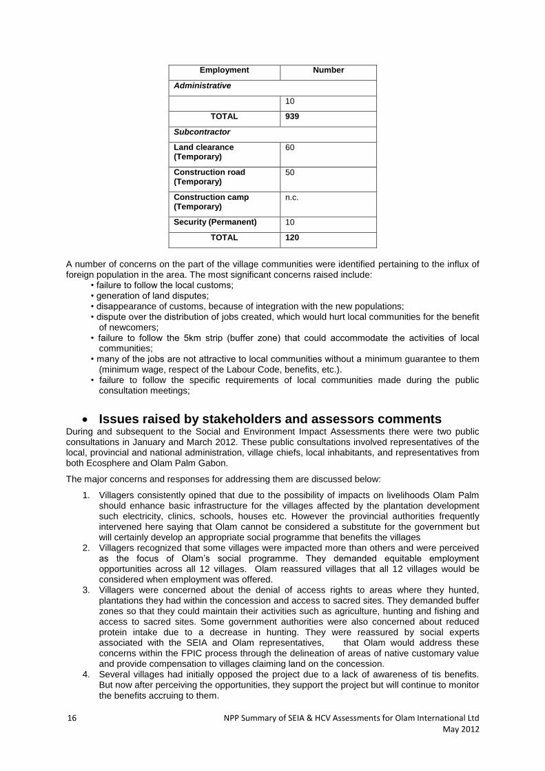
Jobs will be created through infrastructure development for the palm oil plantation. Subcontractors are expected to hire their workforce locally. One of the responsibilities of the monitoring committee (a standing committee of company and community representatives) will be to initiate micro projects which build the capacity of the local workforce. The jobs being created will fall under two categories: temporary, which are those lasting for a limited amount of time (ie. road construction) and permanent, more sustainable roles (harvesters, maintenance workers, social workers, administration, health and safety). This infrastructure development is likely to generate a dynamic economy in the region.
Employment Number
Permanent
Plantation
Maintenance 357
Harvest 475
Team Leaders 80
Technical Assistants 10
Managers 2
Mechanics
Mechanic 4
Workshop Leader 1
Bindougoulou, Mbamba, Miniengui, Remboè, Douguehi, Ngounié
Moudouma Moabi, Mbamba, Mamimba, Diga, Dougoumbi, Ngouniè
Ningui Ngounié, Dougoumbi, Mossanda, Nzokou, Petit Nzokou
St Martin des Apindji Ndoubou, Leyeye, Ngounié
Migabé Leyeye, Dourembou, Woupou-Woupou, Remboué, Ngounié
16 NPP Summary of SEIA & HCV Assessments for Olam International Ltd May 2012
Employment Number
Administrative
10
TOTAL 939
Subcontractor
Land clearance (Temporary)
60
Construction road (Temporary)
50
Construction camp (Temporary)
n.c.
Security (Permanent) 10
TOTAL 120
A number of concerns on the part of the village communities were identified pertaining to the influx of foreign population in the area. The most significant concerns raised include:
• failure to follow the local customs; • generation of land disputes; • disappearance of customs, because of integration with the new populations; • dispute over the distribution of jobs created, which would hurt local communities for the benefit
of newcomers; • failure to follow the 5km strip (buffer zone) that could accommodate the activities of local
communities; • many of the jobs are not attractive to local communities without a minimum guarantee to them
(minimum wage, respect of the Labour Code, benefits, etc.). • failure to follow the specific requirements of local communities made during the public
consultation meetings;
Issues raised by stakeholders and assessors comments During and subsequent to the Social and Environment Impact Assessments there were two public consultations in January and March 2012. These public consultations involved representatives of the local, provincial and national administration, village chiefs, local inhabitants, and representatives from both Ecosphere and Olam Palm Gabon.
The major concerns and responses for addressing them are discussed below:
1. Villagers consistently opined that due to the possibility of impacts on livelihoods Olam Palm should enhance basic infrastructure for the villages affected by the plantation development such electricity, clinics, schools, houses etc. However the provincial authorities frequently intervened here saying that Olam cannot be considered a substitute for the government but will certainly develop an appropriate social programme that benefits the villages
2. Villagers recognized that some villages were impacted more than others and were perceived as the focus of Olam’s social programme. They demanded equitable employment opportunities across all 12 villages. Olam reassured villages that all 12 villages would be considered when employment was offered.
3. Villagers were concerned about the denial of access rights to areas where they hunted, plantations they had within the concession and access to sacred sites. They demanded buffer zones so that they could maintain their activities such as agriculture, hunting and fishing and access to sacred sites. Some government authorities were also concerned about reduced protein intake due to a decrease in hunting. They were reassured by social experts associated with the SEIA and Olam representatives, that Olam would address these concerns within the FPIC process through the delineation of areas of native customary value and provide compensation to villages claiming land on the concession.
4. Several villages had initially opposed the project due to a lack of awareness of tis benefits. But now after perceiving the opportunities, they support the project but will continue to monitor the benefits accruing to them.
NPP Summary of SEIA & HCV Assessments for Olam International Ltd May 2012 17
A number of meetings took place in Libreville and Mouila, as shown below.
Stakeholder consultation in Libreville
A process of consultation of stakeholders (ANPN, CARPE, DGEPN, PAPPFG, WCS, WWF) of the project proposed by Olam Palm Gabon, was undertaken by the firm Proforest in Libreville, on issues of HCV and local communities, in February 2012. Emerging from the stakeholder consultation the following concerns, among others, have been issued (full details in Proforest’s main HCV report):
Verify the existence of certain species of Caesalpiniaceae (Hymenostegia sp.) in the project area;
Develop a management plan of the great apes (gorillas, chimpanzees);
Develop a strategy for managing conflict with elephants;
Assess in greater detail the populations of priority species with appropriate methods.
Assess the amount of carbon in the project area by the method approved by Gabon;
Consider potential archaeological and historical sites present in the project area;
Develop a management plan for pesticides and fertilizers in the project Olam Palm Gabon;
Evaluate through detailed hydrological modelling and direct verification the full extent and duration of seasonal flooding.
Take into account the requirements of local communities;
Public consultations in major community groupings of the project area of Mouila
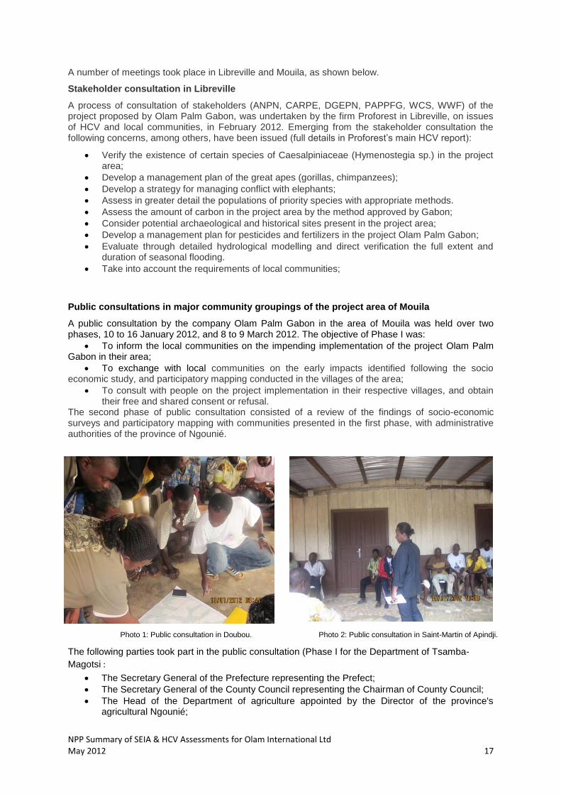
A public consultation by the company Olam Palm Gabon in the area of Mouila was held over two phases, 10 to 16 January 2012, and 8 to 9 March 2012. The objective of Phase I was:
To inform the local communities on the impending implementation of the project Olam Palm Gabon in their area;
To exchange with local communities on the early impacts identified following the socio economic study, and participatory mapping conducted in the villages of the area;
To consult with people on the project implementation in their respective villages, and obtain their free and shared consent or refusal.
The second phase of public consultation consisted of a review of the findings of socio-economic surveys and participatory mapping with communities presented in the first phase, with administrative authorities of the province of Ngounié.
Photo 1: Public consultation in Doubou. Photo 2: Public consultation in Saint-Martin of Apindji.
The following parties took part in the public consultation (Phase I for the Department of Tsamba-
Magotsi :
The Secretary General of the Prefecture representing the Prefect;
The Secretary General of the County Council representing the Chairman of County Council;
The Head of the Department of agriculture appointed by the Director of the province's agricultural Ngounié;
18 NPP Summary of SEIA & HCV Assessments for Olam International Ltd May 2012
The Brigade Commander;
Residents of several villages located in the vicinity of the project. For the Department of Douya-Onoye:
The Secretary General of the Prefecture representing the Prefect;
The Chairman of the County Council;
The Secretary General of the County Council;
An Officer of the Provincial Forestry representing the agricultural provincial director.
The Head of the agricultural sector commissioned by the director of the agricultural province;
The Brigade Commander;
The Deputy Brigade Commander;
Residents of several villages located in the vicinity of the project.
The participation in the second phase of the consultation involved all the administrative authorities of the province of Ngounié, the public and the leaders of 12 villages (Ningui being absent). The list of participants in the public consultation, the minutes of meetings and the Minutes of the circumstance, are appended to the SEIA report.
5. Summary of assessment findings for HCV assessments
Data sources and quality
The data sources used in the HCV assessment are primarily the expert reports developed by Ecosphere consultants based on their field assessments, supplemented extensively by Proforest’s background knowledge and consultations with independent experts. Data quality issues include:
Poor available background data on the hydrology, rainfall, topography, social and biodiversity of this area of Gabon, which has been little-studied.
Field studies conducted during the rainy season, severely hampering faunal assessments in particular, and preventing access to the more difficult terrain close to the Ngounié River.
Initial refusal of some villages to participate in social assessments.
HCV toolkits employed
The HCV National Toolkit for Gabon was the main HCV reference document for this study. The HCV tool kit and the Gabonese National HCV Interpretation were used as guiding documents. The Gabonese National HCV Interpretation is still in draft form and there is no direct guidance on the identification of HCVs in grasslands or on the management of HCVs in the context of industrial scale oil palm plantations. Therefore, Proforest conducted consultations with experts and accompanied the SEIA technical staff during field studies in order to provide guidance on the interpretation of field survey results and to determine the status of HCVs in the Mouila concession site.
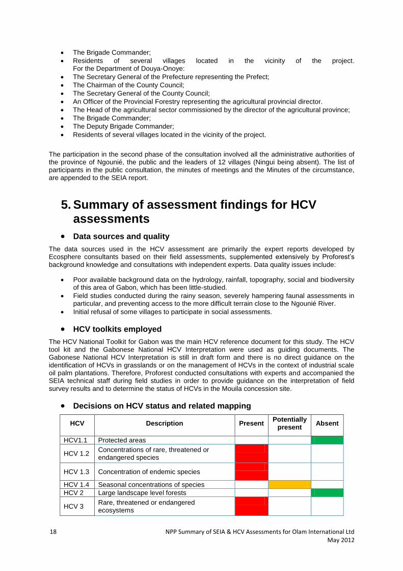
Decisions on HCV status and related mapping
HCV Description Present Potentially
present Absent
HCV1.1 Protected areas
HCV 1.2 Concentrations of rare, threatened or endangered species
HCV 1.3 Concentration of endemic species
HCV 1.4 Seasonal concentrations of species
HCV 2 Large landscape level forests
HCV 3 Rare, threatened or endangered ecosystems

NPP Summary of SEIA & HCV Assessments for Olam International Ltd May 2012 19
HCV 4.1 Forest areas critical to water catchments
HCV 4.2 Forest areas critical to erosion control
HCV 4.3 Forest areas providing natural barriers to destructive fire
HCV 5 Forest areas fundamental to meeting basic needs of local communities
HCV 6 Forest areas critical to local communities traditional cultural identity
A detailed map of HCV management areas is provided below (but subject to changes after the completion of further hydrological modelling and validation by an independent expert). It requires a detailed hydrological model of the floodplains and ground-truthing to set aside HCV 3 flooded forests. The map below provides a draft spatial plan designed to meet the objectives of biodiversity conservation for HCV 1, HCV 3 and HCV 4. The plan outlines a contiguous conservation area spanning the concession, with three main features:
A large area of seasonally flooded forest and savannah in the NW (Igegi/Ngounie floodplains);
The low-lying and poorly drained, seasonally flooded portion of the “Central Bowl”;
A 300+ m buffer along most of the length of the Ngounie River.
This map will also need to be combined with HCV 5 and HCV 6 area (e.g. see Figure 1 & 2). Significant areas of HCV 3 and HCV 4.1 forest are linked in two places through the use of habitat corridors, which are essential for the proposed Great Ape management plan. The corridor linking the “Central Bowl” to the Igegi floodplain should be crossed by a single, narrow road to provide access to the plantation area closest to the Ngounie (area C on map below). The broad floodplains of the main tributary rivers have also been included as HCV 3 and HCV 4.1 conservation areas, whilst riparian buffers have been added to the streams outside of the conservation areas.

20 NPP Summary of SEIA & HCV Assessments for Olam International Ltd May 2012
2
1
3
4
5
A
B
C
Seasonally flooded savannah area providing habitat for buffalo, elephant, and other grazing ungulates
Floodplain of the Igegi river
and tributaries
Conservation corridor between “Central bowl” and Igegi/Ngounie
flooded forests
Conservation corridor between “Central bowl” and Dakar/Ngounie flooded forests
Flooded forest of the “Central bowl”
Broad floodplains of Douya
and Doubou rivers
Broad floodplains of the Rembo and its tributaries
NPP Summary of SEIA & HCV Assessments for Olam International Ltd May 2012 21
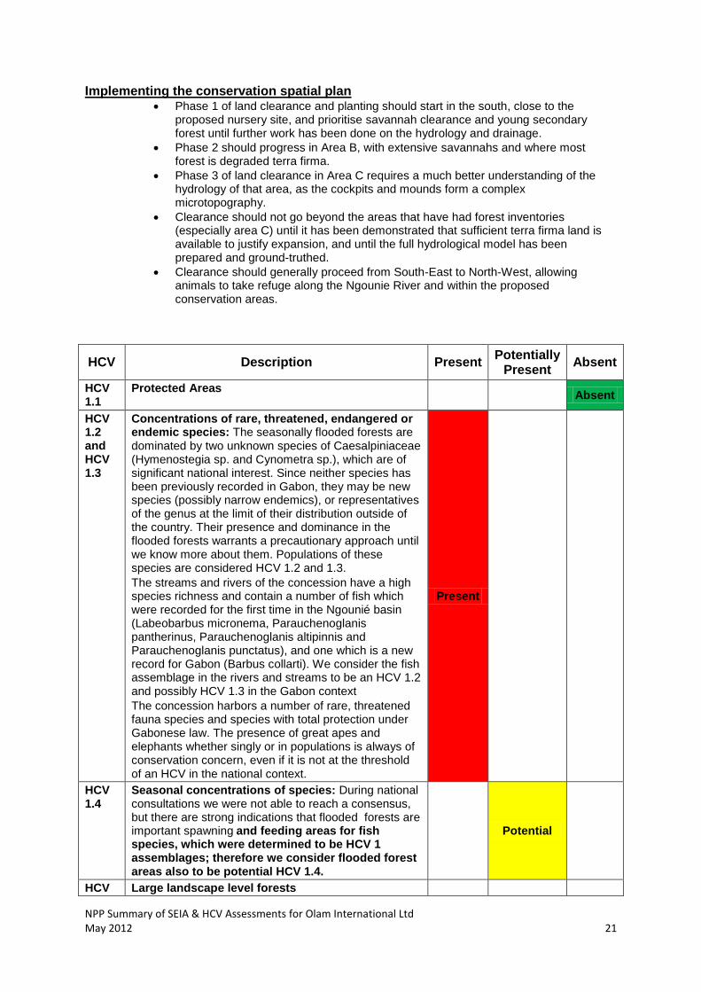
Implementing the conservation spatial plan Phase 1 of land clearance and planting should start in the south, close to the
proposed nursery site, and prioritise savannah clearance and young secondary forest until further work has been done on the hydrology and drainage.
Phase 2 should progress in Area B, with extensive savannahs and where most forest is degraded terra firma.
Phase 3 of land clearance in Area C requires a much better understanding of the hydrology of that area, as the cockpits and mounds form a complex microtopography.
Clearance should not go beyond the areas that have had forest inventories (especially area C) until it has been demonstrated that sufficient terra firma land is available to justify expansion, and until the full hydrological model has been prepared and ground-truthed.
Clearance should generally proceed from South-East to North-West, allowing animals to take refuge along the Ngounie River and within the proposed conservation areas.
HCV Description Present Potentially
Present Absent
HCV 1.1
Protected Areas Absent
HCV 1.2 and HCV 1.3
Concentrations of rare, threatened, endangered or endemic species: The seasonally flooded forests are dominated by two unknown species of Caesalpiniaceae (Hymenostegia sp. and Cynometra sp.), which are of significant national interest. Since neither species has been previously recorded in Gabon, they may be new species (possibly narrow endemics), or representatives of the genus at the limit of their distribution outside of the country. Their presence and dominance in the flooded forests warrants a precautionary approach until we know more about them. Populations of these species are considered HCV 1.2 and 1.3.
The streams and rivers of the concession have a high species richness and contain a number of fish which were recorded for the first time in the Ngounié basin (Labeobarbus micronema, Parauchenoglanis pantherinus, Parauchenoglanis altipinnis and Parauchenoglanis punctatus), and one which is a new record for Gabon (Barbus collarti). We consider the fish assemblage in the rivers and streams to be an HCV 1.2 and possibly HCV 1.3 in the Gabon context
The concession harbors a number of rare, threatened fauna species and species with total protection under Gabonese law. The presence of great apes and elephants whether singly or in populations is always of conservation concern, even if it is not at the threshold of an HCV in the national context.
Present
HCV 1.4
Seasonal concentrations of species: During national consultations we were not able to reach a consensus, but there are strong indications that flooded forests are important spawning and feeding areas for fish species, which were determined to be HCV 1 assemblages; therefore we consider flooded forest areas also to be potential HCV 1.4.
Potential
HCV Large landscape level forests
22 NPP Summary of SEIA & HCV Assessments for Olam International Ltd May 2012
HCV Description Present Potentially
Present Absent
2
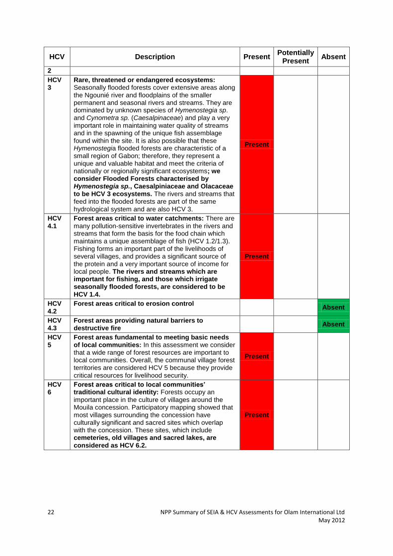
HCV 3
Rare, threatened or endangered ecosystems: Seasonally flooded forests cover extensive areas along the Ngounié river and floodplains of the smaller permanent and seasonal rivers and streams. They are dominated by unknown species of Hymenostegia sp. and Cynometra sp. (Caesalpinaceae) and play a very important role in maintaining water quality of streams and in the spawning of the unique fish assemblage found within the site. It is also possible that these Hymenostegia flooded forests are characteristic of a small region of Gabon; therefore, they represent a unique and valuable habitat and meet the criteria of nationally or regionally significant ecosystems; we consider Flooded Forests characterised by Hymenostegia sp., Caesalpiniaceae and Olacaceae to be HCV 3 ecosystems. The rivers and streams that feed into the flooded forests are part of the same hydrological system and are also HCV 3.
Present
HCV 4.1
Forest areas critical to water catchments: There are many pollution-sensitive invertebrates in the rivers and streams that form the basis for the food chain which maintains a unique assemblage of fish (HCV 1.2/1.3). Fishing forms an important part of the livelihoods of several villages, and provides a significant source of the protein and a very important source of income for local people. The rivers and streams which are important for fishing, and those which irrigate seasonally flooded forests, are considered to be HCV 1.4.
Present
HCV 4.2
Forest areas critical to erosion control Absent
HCV 4.3
Forest areas providing natural barriers to destructive fire
Absent
HCV 5
Forest areas fundamental to meeting basic needs of local communities: In this assessment we consider that a wide range of forest resources are important to local communities. Overall, the communal village forest territories are considered HCV 5 because they provide critical resources for livelihood security.
Present
HCV 6
Forest areas critical to local communities’ traditional cultural identity: Forests occupy an important place in the culture of villages around the Mouila concession. Participatory mapping showed that most villages surrounding the concession have culturally significant and sacred sites which overlap with the concession. These sites, which include cemeteries, old villages and sacred lakes, are considered as HCV 6.2.
Present
NPP Summary of SEIA & HCV Assessments for Olam International Ltd May 2012 23
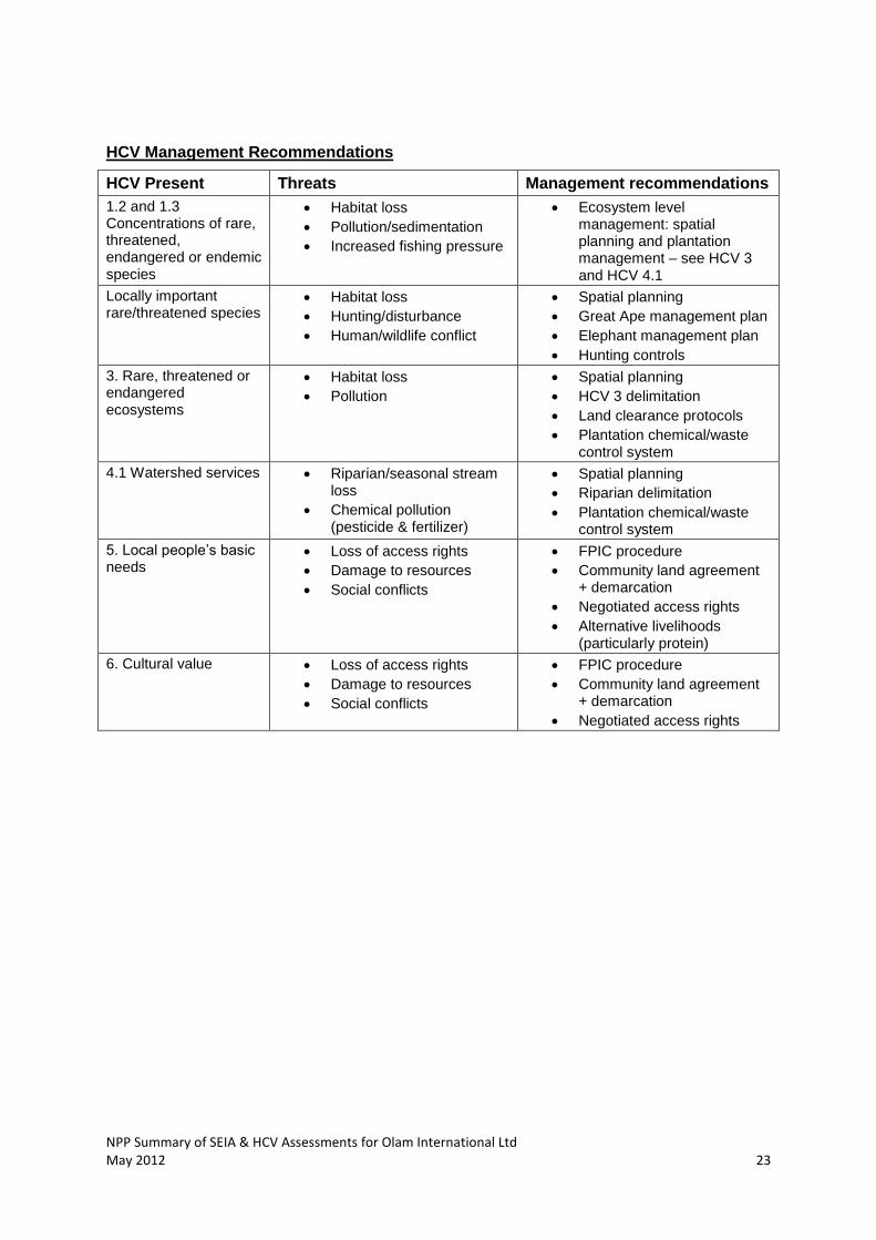
HCV Management Recommendations
HCV Present Threats Management recommendations
1.2 and 1.3 Concentrations of rare, threatened, endangered or endemic species
Habitat loss
Pollution/sedimentation
Increased fishing pressure
Ecosystem level management: spatial planning and plantation management – see HCV 3 and HCV 4.1
Locally important rare/threatened species
Habitat loss
Hunting/disturbance
Human/wildlife conflict
Spatial planning
Great Ape management plan
Elephant management plan
Hunting controls
3. Rare, threatened or endangered ecosystems
Habitat loss
Pollution
Spatial planning
HCV 3 delimitation
Land clearance protocols
Plantation chemical/waste control system
4.1 Watershed services Riparian/seasonal stream loss
Chemical pollution (pesticide & fertilizer)
Spatial planning
Riparian delimitation
Plantation chemical/waste control system
5. Local people’s basic needs
Loss of access rights
Damage to resources
Social conflicts
FPIC procedure
Community land agreement + demarcation
Negotiated access rights
Alternative livelihoods (particularly protein)
6. Cultural value Loss of access rights
Damage to resources
Social conflicts
FPIC procedure
Community land agreement + demarcation
Negotiated access rights
24 NPP Summary of SEIA & HCV Assessments for Olam International Ltd May 2012
Free, Prior and Informed Consent The process to obtain FPIC among villages surrounding the concession is an on-going process which has commenced. From the 6 steps recommended for completing the FPIC process, each of which have several key components, the social team of Olam Palm Gabon have completed the following actions against each step:
1. Step 1(SEIA): The SEIA has been submitted to the Director General of Environment, subsequent to public consultations informing all stake-holders about the impacts of the project and addressing any concerns raised. The SEIA also includes a study for the impact of the project on subsistence activities (farming, hunting, gathering, collection and fishing) in and around the concession area and the recommended action to mitigate this.
2. Step 2: (Elaboration of the FPIC process to stakeholders): The details of the FPIC process have been elaborated to local communities and relevant provincial and national government agencies. An information campaign on impacts of the project is presently underway. A register of information requested, issues, claims and complaints has been opened in the offices of Olam, the Prefectures of Mouila and Fougamou and villages potentially affected by the project. Furthermore a list of all stake-holders is maintained and a record of communications, consultations and actions arising from these, is regularly updated.
3. Step 3: (Identification of stakeholders, definition of participative modes of consultations, representation and negotiations): A steering committee to monitor and guide the FPIC process has been established.
4. Step 4 (Identification of the persons affected by the project and estimation of indemnification required): An agricultural inventory was carried out to identify owners of crops, plantations and timber permits within the concession, allowing Olam Gabon to plan for indemnification of owners in accordance to Gabonese law.
The last two steps, 5 and 6, facilitate obtaining free, prior and informed consent from the villagers and other stakeholders formally, validated through a social contract and a ritualization ceremony. Carrying out each action is supported by documentary evidence signed by the relevant stakeholders and Olam Palm Gabon.

NPP Summary of SEIA & HCV Assessments for Olam International Ltd May 2012 25
Internal responsibility
This document is the summary of SEIA (Social and Environmental Impact Assessment) and HCV (High Conservation Value) assessments for the 35,354 hectares area north of Mouila proposed for development of oil palm plantations by Olam Palm Gabon and has been accepted by the Management of Olam Palm Gabon. We the undersigned accept responsibility for the assessments and summary.
Signed on behalf of SEIA assessors Signed on behalf of HCV Assessors
Ecosphere SARL, Gabon Proforest Ltd, UK
The assessment results for the SEIA and HCV assessments carried out by Ecosphere SARL and Proforest Ltd. Summarized here are accepted as part of the guidelines for managing the Olam Palm Mouila concession of 35,354 hectare in Ngounie Province, Gabon.
Alexandra Booth Manager-Sustainability
Palm Division, Olam International