RRA REPORT OF XISHUANGBANNA DAI NATIONALITY · PDF fileXishuangbanna Dai Nationality...
48
Regional Environmental Technical Assistance 5771 Poverty Reduction & Environmental Management in Remote Greater Mekong Subregion Watersheds Project (Phase I) RRA REPORT OF XISHUANGBANNA DAI NATIONALITY AUTONOMOUS PREFECTURE Watershed Profile By Bo Zhou Meng Guangtao Fang Bo Dai Yiyuan CONTENTS 1. BACKGROUND Xishuangbanna Dai Nationality Autonomous Prefecture is located in Southwest part of Yunnan Province, 99 o 58 o to 101 o 50 o E, and 21 o 09 o to 22 o 36 o N, with a total land area of 19,124.5 km 2 , of which hills and mountains account for 95%. The Prefecture borders Burma and Lao PDR. There is a provincial route of highway accessible to the capital Jinghong City of the Prefecture from provincial capital Kunming, with the length of about 730 km. The flights from Kunming to Jinghong only take about 50 minutes. 1. BACKGROUND 2. SELECTION OF SAMPLE VILLAGES 3. ROUGH AND ELEMENTARY OPINIONS 3.1 Traditional Land and Natural Resource Use Patterns Affecting Environment 3.2 Elementary Opinion of Education, Health, and Development Plan 3.3 Land Use Conditions 3.4 Agricultural Production Technologies 3.5 Human Pressures to Forest Resources 4. SUGGESTIONS Page 1 of 8
Transcript of RRA REPORT OF XISHUANGBANNA DAI NATIONALITY · PDF fileXishuangbanna Dai Nationality...

Regional Environmental Technical Assistance 5771 Poverty Reduction & Environmental Management in Remote Greater
Mekong Subregion Watersheds Project (Phase I)
RRA REPORT OF XISHUANGBANNA DAI NATIONALITY AUTONOMOUS PREFECTURE
Watershed Profile
By
Bo Zhou Meng Guangtao
Fang Bo Dai Yiyuan
CONTENTS
1. BACKGROUND
Xishuangbanna Dai Nationality Autonomous Prefecture is located in Southwest part of Yunnan Province, 99o58 o to 101 o 50 o E, and 21 o 09 o to 22 o 36 o N, with a total land area of 19,124.5 km2, of which hills and mountains account for 95%. The Prefecture borders Burma and Lao PDR. There is a provincial route of highway accessible to the capital Jinghong City of the Prefecture from provincial capital Kunming, with the length of about 730 km. The flights from Kunming to Jinghong only take about 50 minutes.
1. BACKGROUND
2. SELECTION OF SAMPLE VILLAGES
3. ROUGH AND ELEMENTARY OPINIONS
3.1 Traditional Land and Natural Resource Use Patterns Affecting Environment
3.2 Elementary Opinion of Education, Health, and Development Plan
3.3 Land Use Conditions
3.4 Agricultural Production Technologies
3.5 Human Pressures to Forest Resources
4. SUGGESTIONS
Page 1 of 8

Xishuangbanna Dai Nationality Autonomous Prefecture is also located in the drainage area of Lancang River water systems, in which 2,762 great and small rivers are distributed. Mainly, there are 16 arterial anabranches such as Luosuo River, Nanla River, Liusha River, Nanxian River, and Nanguo River, and 65 secondary anabranches in the region. The great rivers (main streams) flow 187.5 km in the Prefecture. There are 53 waterpower stations in the region, with 61,003 kilowatts of installed capacity in total.
Under influences of both the Indian Ocean monsoon and the Pacific Ocean monsoon, the region has characteristics of monsoon climate in the transition zone of northern tropics and southern subtropics. All the year round, dry season and rainy season are clearly demarcated. The mean annual precipitation is 1,193.7–2,491.5 mm, while the mean annual temperature is in the range from 15.1 to 21.7�. The rainy season ranges from May to October every year, and the precipitation in the rainy season accounts for 84.1% of the all-year total.
Xishuangbanna Dai Nationality Autonomous Prefecture covers one city and two counties, i.e., Jinghong City, Menghai County, and Mengla County, and 40 townships, 198 administrative villages, 2,095 villager committees, and 11 state-own farms. Among 40 townships, there are 7 townships belonging to 506 aid-the-poor townships of Yunnan Province, which are charged as fortified positions by Provincial Government (average annual incomes for individuals below 500 CNY according to the fixed price in 1990, and average annual possessing food for individuals below 300 kg). Average annual incomes for individuals and average annual possessing food for individuals of agricultural population of the whole Prefecture are 1,471 CNY and 664 kg respectively. In whole Prefecture, present poverty population is 50 thousand people, of which minority population represents over 95%. According to statistic results in 1997, the length of frontier line in the Prefecture is 966.29 km, and the total land area is 19,124.5 km2. Of which, the area of infields and farmlands is 104,000 ha, with 123,840 ha of plantations, 10,444.67 ha of forestlands, 596,333.3 ha of barren-lands and grasslands, 18,666.67 ha of water areas, and 25,160 ha of other kinds of land. Owing to unreasonable land use system, the area of soil and water loss accounts for 29.03% of the Prefecture’s total. With the development of crop production, there is a trend that the areas of soil and water loss will be further expanded in the near future.
The total population of Xishuangbanna Dai Nationality Autonomous Prefecture is 838,400 people inhabiting in 212,201 families, of which the total minority population is 619,220 people, accounting for 73.86% of the Prefecture’s total. The natural population growth rate is 5.58%. Among the minority population, the population of Dai minority represents 34.66%, with 18.84% of Hani people, 5.69% of Lahu people, 4.17% of Bulang people, 4.2% of Yi people, 2.1% of Jinuo people, and 1.9% of Yao people. Census and statistic data of the Prefecture revealed that the population mounts up rapidly. For instance, the total population of the Prefecture was 210,349 people in 1950, 240,751 people in 1955, 311,054 people in 1960, 402,894 people in 1965, 480,005 people in 1970, 598,212 people in 1975, 622,522 people in 1980, 691,442 people in 1985, 781,710 people in 1990, and 817,772 people in 1995. We can get the information from above data that the total population of the Prefecture has increased 2.89 times in late four decades.
The Governments of Xishuangbanna Dai Nationality Autonomous Prefecture have been recognising and thinking much of education and health care. There are only 2 middle schools and 11 elementary schools in the whole Prefecture in 1950, in which 20 teachers were engaged and 300 students were enrolled. In 1997, however, there are 61 middle schools and 545 elementary schools in the Prefecture, in which allocated 8,911 teachers and recruited 140,941 students. In whole Prefecture, 254 health institutions have been established, in which 9,809 doctors, nurses, and other professional health workers are engaged in their occupations. Every township has one Township Health Centre.
Basically, Dai, Han, Hui, and Bai people who are engaged in paddy plantation and handicraft industry live in basins; so, we call them as basin nationalities or basin residents. Hani, Lahu, Jinuo, Bulang, and Yao people who are engaged in wadi and tea plantation, as well as collection and cultivation of other economic plants, live in mountainous areas; so, we name them as mountainous nationalities or mountainous residents.
Minority autonomous policies make the minority population grow in a certain extent. However, the growth of population, the widespread practices of slash-and-burn agriculture, and the continuous expansion of rubber plantation have resulted in further degradation of forests and environment. For instance, the area of tropical rain forests is 520,000 ha now, which has decreased about 40% comparing with the total in 1975. The area of rubber plantation please refers to annex.
Xishuangbanna National Nature Reserve is located in 21 o 10 o –22 o 14 o of northern latitude, and 100 o 16 o
–101 o 50 o of eastern longitude. The Nature Reserve was approved/admitted as a network member of MAB by UNESCD in October 1993. The total area of the Nature Reserve is 241,776 ha, accounting for 12.6% of the Prefecture’s total. The core area of the Nature Reserve covers 126,566.6 ha, representing 52.4% of the
Page 2 of 8

Nature Reserve’s total, while experimental zone covers 115,209.4 ha, accounting for 47.6% of the total. The main purpose of the Nature Reserve is to protect tropical rain forests, monsoon rain forests, rare wildlife population, and their habitats. Xishuangbanna is not only the most enrichment area of species in China, but it is also the region where has the highest value of biodiversity protection.
2. SELECTION OF SAMPLE VILLAGES
According to requirements of the Outline of Project Report, we, survey team, have comprehensively analysed many factors as follows:
1) Not the same sites of other foreign projects;
2) Minority villages;
3) Relative poor villages;
4) Degree or extent of land degradation;
5) Present condition of agricultural ecosystems; and
6) Other factors.
After survey team and the Prefecture Government officials’ repeated argumentation, we selected four natural villages as our sampling villages. The four villages and their features are detailed as follows:
A. Xiaonuoyou Down Village, located inside Bannahe Provincial Nature Reserve, is the village in which Lahu minority lives. The Village is subordinated to Mengsong Township that is one of the 506 aid-the-poor townships of Yunnan Province, which are charged as fortified positions by Provincial Government.
B. Mansaoxiu Natural Village, located in basin area surrounding Mangao Nature Reserve, is the village in which Dai minority lives. The reason why we chose it as sample village is that the village is located in basin area, but its economic development is very behindhand comparing with other villages in basin areas.
C. Manping Natural Village, located in experimental zone of Shangyong Nature Reserve, is the village in which Yao minority lives. The village is one of the relocated villages from core area of the Nature Reserve.
D. Naxiu Natural Village, located in experimental zone of Mengla region of the Natural Reserve, is the village in which Hani minority lives. The village is one of the 17 aid-the-poor villages of Mengla County, which are charged as fortified positions by the County Government.
The four villages we selected contain main minorities of Xishuangbanna Dai Nationality Autonomous Prefecture, of which not only includes basin nationalities such as Dai minority, but mountainous nationalities have also been involved, such as Hani, Lahu, and Yao minorities. All four villages are typical poor villages, which are located in the areas inside or surrounding the Nature Reserves. Under the influences and affections of living custom and economic condition, the sampling villages have their respective characteristics of resource utilisation and environment degradation.
We, using Village Profile Chart, Problem Analysis Chart, and Questionnaire for Household Interview, have taken the interview method of semi-structure. Four villages’ interviews have been accomplished through filling Village Profile Charts for each village, filling 12 Questionnaires for Household Interview during interview. At the same time, using relief map of the region where the sample village is located, we have drawn land use systems and types for each village. Moreover, combining field investigation, we have identified the range and outline of soil and water loss and land degradation, and analysed the reason resulting in soil erosion, soil and water loss, and land degradation and probable approaches and solutions.
We have collected a lot of secondary information from different authority institutions, such as Prefecture Government, Prefecture Bureau of Environment Protection, Prefecture Aid-the-Poor Office, and Management
Page 3 of 8

Bureau of Nature Reserve, and many County-level institutions such as Bureau of Environment Protection and Statistic Bureau of Menghai County and Mengla County. We organised many colloquia with participants of administrative officials of the Prefecture, Counties, and Townships respectively. From the colloquia, basic characteristics of the Prefecture and basic situations of communities surrounding the Nature Reserve were available, which provided the greatest help for our selection of sampling villages.
3. ROUGH AND ELEMENTARY OPINIONS
3.1 Traditional Land and Natural Resource Use Patterns Affecting Environment
In the long period of historical development, every nationality in Xishuangbanna harmoniously gets along with the nature, such as Dai people’s culture of sacred forest and hill, artificial fuelwood forests, paddy agriculture, and etc. All of these perfect custom and patterns are compliant with local ecological environment. If we earnestly make a conclusion of the custom and patterns, we can extend them to other regions where have the similar natural background, such as Burma and Thailand. Mountainous residents’ main agricultural production pattern is the widespread practice of slash-and-burn agriculture. Based on plentiful lands and adopting proper methods, traditional slash-and-burn agriculture does not take more affection to the environment. Moreover, through the agriculture pattern, sufficient manure and fertiliser will be gained from forests, and the fire used in the slash-and-burn agriculture may benefit for weed and pest and vermin control. Overmuch, with the social development, population expansion, the slash-and-burn agriculture undoubtedly brings on serious degradation of environment. The problems raised from crop production in the three investigated villages also show human severe pressure to natural environment.
3.2 Elementary Opinion of Education, Health, and Development Plan
The education condition of the Autonomous Prefecture still stay in the primary phrase, and there is no college or university in the Prefecture. In 1991, there are only 7,362 students who graduated from vocational schools and middle schools. Most residents in Xishuangbanna Autonomous Prefecture are illiteracy. More than half of residents over 12-year old cannot read. Excepting Jinuo minority, two third of mountainous residents are illiteracy, and most of them are female. In the rural area, it is essential to develop complete elementary schools and to popularise elementary education.
The lowest level institution of health care has been built in administrative villages. In the whole Prefecture, every administrative village has one rural clinic, in which only one or two health workers are employed. The health worker only can treat some simple and common diseases and carry out immunity work of maternity and child assigned from upper health institutions and governments. Four investigated villages are located in remote areas, resulting in conditions of lack of doctor and shortage of medicines, and it is very difficult to see a doctor for local people.
In poor villages, the incompletely settled problem of drinking water cannot guarantee local villagers’ clean drinking water, which severely threatens villagers’ health. Most of villagers were infected by malaria, with high incidence of the disease.
Mountainous villages are lacking of agricultural techniques and preventive knowledge of livestock diseases. Commonly, administrative village has no agricultural technician and veterinarian to provide appropriate services for local farmers. Excepting Mansaoxiu Natural Village, no hold a training course on agricultural technologies in other investigated villages.
The lowest level institutions of Rural Credit Union were established in the places where the township governments are located. Common rural people hardly to be granted a loan from Rural Credit Union. Micro-credit, which has gained obvious and great achievements in other areas of Yunnan Province, is not extended into these regions. We, survey team, have learnt from field investigation that rural development is restricted by lack of financial resources, resulting in good projects and plans cannot to be implemented although local villagers have many nice desirability and programs.
3.3 Land Use Conditions
In 1980s, same as other regions all around China, the contract responsibility system of farmlands has been carried out in Xishuangbanna Dai Nationality Autonomous Prefecture. Farmers and villagers can plant all
Page 4 of 8

kinds of crops as their wishes and gain profits from the responsibility lands. According to the policy of ‘Liangshan (two kinds of forests in mountains in Chinese, i.e., responsibility forests and household forests) allocated to households’, local villagers can independently manage these two kinds of forests and forestlands, while Villager Committee on the behalf of villages enforce the ownership of collective forests. Originally, according to custom and practices of slash-and-burn agriculture in mountainous villages, local governments demarcated a certain areas for shifting cultivation. Every household can reclaim dry lands in these areas base on their labour force capacity. Since 1998, Central Government and Provincial Government have been conducting Natural Forests and Protection Forests Conservation Project in whole country, which requires that dry lands must be fixed, and felling of natural forests are forbidden. And then, activities of destroying forests are strictly controlled. Our survey also find that, for the purposes of matching the requirement of food and expanding economic forests, the areas of forests and shifting cultivation, and fishery resources have obviously decreased for late decade. However, damages of environments still can not make local people shake off the poverty, furthermore, made them step in a vicious cycle.
3.4 Agricultural Production Technologies
The productive force level of investigated villages is low, which presents as lack of efficient irrigation systems and lack of agricultural sciences and technologies, resulting in low yields and outputs; for in stance, the yield of paddy lands only ranges from 3,000 to 7,500 kg per ha. Local people cultivate farmlands only once (a season) a year round, that is, the multiple crop index is low. With the expansion of population, four surveyed villages whack up food gross outputs commonly through distending the areas of farmlands. Average annual possessing food for individuals, however, does not increase so much.
3.5 Human Pressures to Forest Resources
The forest coverage of Xishuangbanna Prefecture decreases rapidly. The forest coverage of the Prefecture was 66.9% in 1950, which decreased to 33.9% in 1983. Local people in Xishuangbanna region damage forests in various patterns, which mainly include:
1. Miscarried policies such as the policies of ‘Liangshan allocated to households’ and ‘The Great Leap Forward’;
2. Human pressures arisen from natural population growth and overmuch relocatees, resulting in overmuch developing crop production that commonly give priority to rubber, sugarcane, and tea; and
3. Most energy resources of industries and households thoroughly depend upon forests.
The survey revealed that every household in four investigated villages needs 4 – 5 m3 of fuelwood per year, and local villagers are facing the present condition that forest annual increment is less than annual consumption and sustainable development of forest resources are lacking of potentiality. Therefore, villagers have to go into nature reserves, state forests to collect fuelwood and fell timber. In addition, mountainous residents plant amomum fruit and some other economic crops inside nature reserves - regarded as reasonable development of bio-resources. If it is not strictly controlled, in the near few years, most natural forests will be converted to artificial forests.
4. SUGGESTIONS
(1) Developing education in Xishuangbanna Dai Nationality Autonomous Prefecture is a very important work. It is suitable to take the following activities:
a. To establish complete elementary schools;
b. To establish vocational schools and middle schools;
c. To debase the pass line of college and university enrolments for minority students in Xishuangbanna region; and
d. To develop facilities of newspaper, broadcast, and television related to commonalty education.
Page 5 of 8

(2) Health condition needs to improve.
a. To help local people to alter their imperfect traditional living custom;
b. To resolve the "three accessible" problem for poor villages, i.e., drinking water accessible, electricity accessible, and routes accessible; and
c. To establish prevention and medical treatment systems for human and livestock, in particular prevention of tropical contagious diseases.
(3) Agricultural techniques and agriculture-related facility need to extend and promote.
It is very essential to establish extension and training systems of agricultural techniques, such as management techniques for agriculture cultivation, techniques for pests and diseases and weed control, in rural area, especially, in mountainous villages. Meanwhile, it has great contributions to local people to help them to build efficient irrigation systems for increasing multiple crop index and single yield of paddy lands. Increment of food yield not only can match local needs, but also can bring a certain economic incomes for local people.
(4) Management measures of natural forests need to strengthen
Through protecting natural forests, decrease the extent of damaging forests and reclaiming farmland by destroying forests. Xishuangbanna is the unique region where numerous tropical forests have been protected in China. The region is the perfect places to conduct study on biodiversity origins, to organise instructional and educational activities of environment and nature resources. Economic development brings on severe pressure to the environment, meanwhile, is a common phenomenon in the region, which are also valuable instructional materials. For instance, consequences of different land use systems show the great contrasts, which are successions from fresh green tropical rain forests to lots of barren lands due to over-exploitation.
(5) Land use systems need to rationalise
As stated above, since 1998, Central Government and Provincial Government have been conducting Natural Forests and Protection Forests Conservation Project in whole country. The project requires returning the grain plots to forestry, where the gradient is over 25 degree. Aimed at surveyed villages, the following measures are suitable to be taken:
a. To convert slope farmlands to terraces;
b. To establish steady high-yield fertile lands to meet local food consumption;
c. To develop agroforestry systems or Taungya systems to plant high-efficiency tropical economic forests;
d. To develop artificial fuelwood forests, such as planting Cassia siamea.
(6) Suggestions for second phase
After survey and study on the four natural villages, we have analysed integrated factors and conditions of the region in every direction. Based on the visualisation of regions co-operation project in second phase, it is suggested to let feasibility study of second phase emphasise particularly on borders between China and Lao PDR. The village sequence to execute feasibility study is Nanping, Naxiu, Xiaonuoyou Down Village, and Mansaoxiu. Primary plan is to make the sites in China connect with villages in Lao PDR, with their residents’active participation, which will be formed a regions co-operation project, and to implement the feasibility study of second phase as soon as possible.
Table of Rubber Plantation of Xishuangbanna Prefecture
Year 1963 1970 1975 1983 1990 1993 1997
Area (ha) 6,130 18,282 27,227 49,678 88,711 88,911 108,065
Page 6 of 8

Table of Census and Nationality Breakdown of Xishuangbanna Prefecture
Table of Illiterate Rate of Main Nationalities over 12 years old of Xishuangbanna Prefecture
Sources: Yunnan Vital Statistics Compilation, Yunnan People’s Publishing House, 1990; and Yunnan Minority Vital Statistics Data, Yunnan People’s Publishing House, 1992.
Statistic Bureau of Xishuangbanna Dai Nationality Autonomous Prefecture Notes: mu is a Chinese land measure, and 1 ha = 15 mu
Annex to RRA Report Xishuangbanna
Yield (ton) 27 732 1,767 17,426 53,400 123,557
Year Total
(person) Dai (%)
Han (%)
Han (%)
Lahu (%)
Bulang (%)
Yi (%)
Jinuo (%)
Yao (%)
1949 199,300 57.4 0.3 16.0 6.5 6.8 2.2 2.0 1.2
1956 258,645 49.1 8.8 17.8 6.2 7.4 2.3 2.1 2.5
1982 646,449 34.9 28.8 19.1 5.1 4.2 2.4 1.7 1.5
1985 691,462 34.9 28.9 17.6 5.1 4.3 2.6 2.0 1.7
1990 781,710 34.6 25.8 19.7 6.0 4.2 5.0 2.3 1.2
1997 838,400 34.7 26.1 18.8 5.7 4.2 4.2 2.1 1.9
Nationality Dai Han Hani Lahu Bulang Yi Jinuo Yao
Total 39.38 45.09 70.14 82.29 73.55 55.70 50.55 78.51
Male 31.96 30.66 56.10 77.65 63.15 39.42 42.13 63.86
Female 46.88 59.95 84.42 86.98 84.01 72.21 58.65 93.28
1 RRA REPORT OF MANSHAOXIU NATURAL VILLAGE, MENGHAI COUNTY, XISHUANGBANNA DAI NATIONALITY AUTONOMY PREFECTURE
Watershed profile
2 RRA REPORT OF NANPING NATURAL VILLAGE, MENGLA COUNTY, XISHUANGBANNA DAI NATIONALITY AUTONOMY PREFECTURE
Watershed Profile
3 RRA REPORT OF NAXIU NATURAL VILLAGE, MENGLA COUNTY, XISHUANGBANNA DAI NATIONALITY AUTONOMY PREFECTURE
Watershed Profile
Page 7 of 8

4 RRA REPORT OF XIAONUOYOU NATURAL VILLAGE, MENGHAI COUNTY, XISHUANGBANNA DAI NATIONALITY AUTONOMY PREFECTURE
Watershed Profile
Page 8 of 8

Regional Environmental Technical Assistance 5771 Poverty Reduction & Environmental Management in Remote Greater
Mekong Subregion Watersheds Project (Phase I)
Annex to RRA Report Xishuangbanna
RRA REPORT OF MANSHAOXIU NATURAL VILLAGE,
MENGHAI COUNTY, XISHUANGBANNA DAI NATIONALITY
AUTONOMY PREFECTURE
Watershed profile
By
Bo Zhou
1. Description of surveyed villages, size, location, main features of interest
1.1 Size
Manshaoxiu natural village, a village of Dai Nationality, has a total area of 4311 Chinese mu. There are 71 families and 370 persons in the village. The hamlet takes up 93 Chinese mu land.
1.2 Location
With all villagers settling in the foot of the hill, the village, which is at the connection of the flat area and the hilly region, lies in the Mangao Nature Reserve. Its altitude is 1208 meters with the back of the village being hills and the front being paddy fields. It is 6 kilometers far away from the village to Mangao Township and 17 kilometers to Menghai County.
1.3 Main Features of Interest
All villagers with low cultural level belong to Dai nationality. They settle in the edge part of the flat area and the nature reserve as well. There are less forest resources, less cultivated land area and more paddy fields in the area. Sugarcane is mainly planted in the hillside where the situation of the soil degradation is very serious. The villagers' lives are poor.
2. Resource base
� Natural forest
The total area of the natural forest of the village is 750 Chinese mu. The natural forest, which is
Page 1 of 11

more than one kilometer far away from the village, distributes at the altitute range from 1250m to 1310m.
� Plantations
There is nothing but 40 Chinese mu economic forest, which is planted recently, mainly formed by orange, pomelo, longan and lychee. There is not timber forest in the area.
� Water supply
Each family has tap water in the village. The water is drawn into the village with plastic waterpipe from the mountain spring, which is 1.5 kilometer far away from the village.
� Fisheries
The total area of fish farm of the village is 4 Chinese mu now. There are grass carp, blunt-snout, and loach, etc. A part of villagers make full use of the unused fields in winter to raise fish. The total fish production is about 13 tons per year including 2.6 ton fish production provided by unused fields in winter.
� Livestock
Now, because villagers use tractors to plough the field, few people raise buffaloes.
3. Land use pattern
� Shifting cultivation
The total area of rotational tillage land is 30 Chinese mu. They are located in the hillside. The villagers plant upland rice and corn on it.
� Paddy
The total area of the paddy field is 1125 Chinese mu. It lies in the east of the flat area, which is known as the best land. About 148 Chinese mu paddy field is used to plant hybrid rice. And the total yield of the rice is 8168000 kilograms per year.
� Other
The tillage area of corn is 65 Chinese mu with a total production of 65800 kilograms;
The tillage area of potato is 10 Chinese mu with a total production of 67000 kilograms;
The tillage area of peanut is 26 Chinese mu, and the total production of the peanut is 130000 kilograms;
The tillage area of tea is 375 Chinese mu with a total production of 11000 kilograms.
The tillage area of bannana is 46.1 Chinese mu with a total production of 32270 kilograms;
The tillage area of other fruit is 2.4 Chinese mu with a total production of 720 kilograms.
4. Land and resource tenure
Now, villagers are signing the second round of the land contract dating thirty years with
Page 2 of 11

government. On the fixed cultivated land, villagers can decide when and what kind of crops they plant. Without the management of Nature reserve permitting, villagers can not cut any tree except fruit tree planted by them. Since the implement of the protection project of the natural forest, the villagers don't be permitted to cut any living tree. They have to collect deadwood as firewood. So it is difficult to collect firewood.
5. Summary of environmental conditions
� Extent of degradation
Now, the range of the land degradation is bigger. Land degradation is most seriously given expression to sugarcane land, which is generally located in the hillside. With a long run cultivation, the lack of fertilizer and the shortage of protection measures for soil erosion, the soil gradually change into barren resulting in sugarcane growth and production poor. In addition, tea fields suffer land degradation, too. Tea grows together with forest along the hillside without terrace. Reclamation results in land degradation every year. Not applying fertilizer is another important reason of land degradation.
� Resource and land sustainability
Because natural forest is managed and used by the nature reserve, the villagers can just gather deadwood as firewood from it and they have no rights to use these resources. The villagers use improperly the fixed tillage land and tea field leads to land degradation and worse continuity.
Paddy field is located in the flat area where soil erosion is not very serious and the continuity is better.
� Planned development structures, roads, dams, etc
Up to now, there is not new development plan in the village
6. Demographic features
� Population and growth
Up to 1998, there are 71 families and 370 persons in the village. All villagers are Dai Nationality people. Among them, there are 182 male and 188 female. The rate of illiteracy is one third. While in 1982, there were 47 families and 299 persons in the village. We can know from this that population has increased twenty percent in the past 17 years, the rate of population growth is 1.4%.
� Gender issues
There is no sexual distinction in the tradition of Dai nationality. Men and women have equal status. Two children are born in each family. as far as social division of labor is concerned, men lay particular stress on physical labor while women on household chores. Meanwhile, they do other farming work together. Dai nationality professes Buddhism, so boys must go into Buddhism temple to be a monk temporarily and learn Dai nationality culture when they are seven or eight years old.
� Ethnicity and its effect on environmental management and poverty
The Dai people consider human beings and their environment as a whole formed by natural component and artificial component. Among all these components, forest is the most important, for example, there is original forest called "longshan" -- a saint hill, where any life should be protected rigidly and can't be invaded. All families develop the habit of planting firewood forest
Page 3 of 11
near the village.
When they plant paddy rice, Dai nationality villagers never use fertilizer and pesticide resulting in the low yield.
Now, the Dai villagers continue the traditional customs, which is the important reason of low average income.
7. Poverty indicators
7.1 Education
� Current status and opportunity
Manshaoxiu village has an uncompleted primary school with two classes and 46 pupils. After graduated from Grade 4, the pupils have to go to the completed primary school of Mangao Administrational Village. Then, they enter the middle school of Menghai Township, which is 15 kilometers far away from the village.
The villagers who are over 40 years old are general illiteracy. Nobody owns the junior degree in the village. Children often leave off their study after finishing Grade 4 of primary school. However, boys must go into temple to study Dai culture (including Dai language), after they leave the primary school.
� Future scenario
With the Xishuanganna Autonomy prefecture government attaching importance to the education, villagers' consciousness of paying attention to education has changed a lot. In the future, the situation of children's education will become better.
7.2 Housing
� Current status
The village is situated at the flat area of the foot of the hill, beside a stream. The whole village is charged with electricity and tap water. Villagers often live in a two-story tile-roofed wooden house, which occupies a total area of 150square meter. The second story is supplied to people to live in, while the first floor is used to raise livestock and poultry or to pile up firewood and stack various household supplies. Round the house, wood or bamboo fence builds a small yard.
Each family has a TV set. There is less furniture in the house and simple equipment in the kitchen. Villagers still use "huotang", which means a pile of dry wood burn on the floor, to cook food.
In each family, there is a sewing machine. The whole village has one TV set, fourteen recorders and three bikes.
� Future opportunity
The common aspiration of villagers is that they can build two-story brick house to improve housing conditions after they become rich.
7.3 Health
� Current picture
There isn't any health worker in the village. If they were sick seriously, the villagers had to see the doctor in the hospital of Menghai County, which is 17 kilometers away from the village. If the
Page 4 of 11

illness isn't serious, they treat it themselves with herbal medicine.
There is a veterinary in the administrational village. He injects bacterin once a year for all livestock. In five years recently, no epidemic disease has taken place.
Because of traditional customs, no toilet is in the village that threatens villagers' health in rainy season.
Polished glutinous rice is villagers' staple food. They eat little meat and the diet isn't very rational, which is harmful to children's growth.
� Future opportunity
With the guide of the government and the improvement of living standard, villagers will abandon their bad traditional customs, improve medicine and health situation and enhance everybody's quality.
7.4 Employment opportunities
Few villagers go out to work. In addition, because of low educational degree, few opportunities they can work in enterprise and institution.
8. Development priorities
The main problems of the natural village are following as:
1. It is very difficult to irrigate paddy field and dry land in dry season.
2. The multiple crop index is low (about 1.06).
3. Villagers know little about agricultural technology.
4. Firewood will be lack in coming future.
To improve the irrigation situation of farmland, it is necessary for villagers to rebuild a dam on the base of destroyed one. To rebuild the dam will submerge 150 Chinese mu land, but local villagers still have a strong wish to do it. After the dam is built, the multiple crop index will be increased greatly and nine villages will make a profit from it (four villages inside the nature reserve and five one outside the nature reserve).
Dai nationality people have the traditional customs of planting firewood forest, so it is possible to solve the problems of the shortage of firewood by enlarging the area of firewood forest.
9. Conclusions and recommendations for Phase
1. Build a dam;
2. Train villagers in practical agricultural technique.
Page 5 of 11

Profile Chart of Mansaoxiu Village
Page 6 of 11

Manshaoxiu Village (1208m. Above sea level, inside the Mangaonatural reserve)
Name of Village:
Mangshaoxiu Village, Menghai Township, Menghai County, Xishuangbanna Dai Autonomous Prefecture
Date: Mar. 28, 1999
Prepared by: Meng Guangtao, Fang Bo, Dai Yiyuan
In discussion with: Ai Xiangdan, position: Chief of Manshaoxiu natural village and with Ai Shai, position: secretary of the Party branch, and with Ai Lou, position: Accountant of the village, etc.
Native language(s) of informants:
Dai language (Chinese while interviewing)
1. Village Location including distances from neChinese mut paved road and from neChinese mut markets town.
Located inside the experimental zone of the Mangao Natural Reserve. 17 kilometers away from the capital town of Menghai County, about 10 kilometers is rough road, the neChinese mut market is the capital town of Menghai County and the Mengzhe township (about 12 kilometers, rough road)
2 kilometers away from the Mangao administrational village
2. Village Population:
No. of families (with approximate ethnic breakdown), no. of people including male/female, age groups breakdown, and the number of immigration and out if available to get the trend of population
Population: 370, families: 71, all Dai people, male: 182, female: 188; (the data of 1998) 299 persons, 47 households
Immigration in: 4, immigration out: none
Birth: 9, death: 5
3. Village History (settlement, culture and belief)
Settlement: Too long, can’t remember. Before the establishment of the People’s Republic of China, more than 200 hundred years.
Culture: The Dai Nationality has its own language and letter, the boy or young people will go to the temple to learn the language. But they married younger than other nationalities; most of the couple only wants two children. Each village has a certain area of "longshan", which means saint hill where they burn the body of death people. It is a saint place for the Dai nationality, and it is forbidden to cut the timber or firewood in the ‘longshan’.
Belief: Buddhism
4. Resource base (ask key informants to sketch a map)
-Total area of paddy land (rainfed, wet-season irrigated, dry-season irrigated)
Irrigated: 1125 Chinese mu (at the east of village), rainfed: 2 Chinese mu (at the opposition hills of the village, at the south-west of village, about 3 kilometers)
Page 7 of 11

Hilly land: 750 Chinese mu (at the east of village, 1 or 2 kilometers)
Shifting cultivation field: 30 Chinese mu
Total area of agriculture land: 1907 Chinese mu
-Total area of natural forest land (now and 30 years ago)
Natural forestland: 750 Chinese mu
30 years ago: about 1500 Chinese mu
‘Longshan’: 93 Chinese mu
One forest ranger employed by the natural reserve, his salary is 90 CNY per month.
-Total area of plantation forest land, if any
Tea yard: 375 Chinese mu; Fruit yard: 40 Chinese mu
-Total area of slash and burn agriculture in a most recent year
None
-Water supplies, access to drinking and bathing water, to water for irrigation
Drinking and bathing water: mountain spring water, purified simply and channeled into village
Water for irrigation: rain; a dam was built in 40 years ago, but it has been damaged and can’t retain water to irrigate the paddy field now. It is difficult to irrigate in dry season.
-Availability of fish (domestic and wild)
Domestic fish: raise the fish in the paddy field, about 10 Chinese mu. It is still stay at the experimental phase.
-Total livestock figures for village
Buffaloes: none
Cattle: none
Pigs: 230
Chicken: difficult to do the statistics
The murrain was found in 1993, the death number of the livestock was few. After then, all of the livestock and poultry are injected kinds of bacterin to prevent from the murrain
The villagers tillage their paddy and dry field with tractors replacing the cattle or buffaloes.
5. Resource Tenure and Management Incentives
-Is forest state-owned, community owned, or household owned?
750 mu of forest collective owned, none forest household owned
-What incentives for rapid/pre-emotive extraction of forest resources exist?
Page 8 of 11

Planting plum. An agricultural technician planted 4-Chinese-mu plum ten years ago, and he has got about 10 thousand-yuan RMB.
Enlargement the area of planting plum
-What incentives for sustainable management of forest resources exist?
There is state-owned forest nearby, and it is forbidden them to lumber in the forest. The villagers can collect deadwood and a few of herbal medicines.
-Describe traditional tenure and management practices and how these may have broken down.
A lot of deforestation while forest ownership not been identification
6. Availability of government/private sector service
-Health service
No clinic rooms in the village, one health workers. There is one toilet in the primary school only, none in the village.
-NeChinese mut school, to what level, use of indigenous languages in primary school
A primary school in the village, there are only two grades (Grade One and Grade Two), using ‘putonghua’ (standard Chinese pronunciation) in class.
There is a temple in the village, where the children can learn Dai language and letter.
-Veterinary services
There is One veterinarian in administrational village, none in natural village.
The villagers purchase the bacterin to inject the livestock or poultry themselves under the direction of the veterinarian.
-Agricultural extension
There is one agricultural technician, two assistance of planting sugarcane in administrational village.
There are 7 times of agricultural technique training organized by the agricultural extension station in the Mangao administrational village each year, including 3 times of training about cultivating rice, 2 times of tea and two times of sugarcane. The technique of raising fish in paddy is popularized in the village at present.
-Agricultural credit
None
-Availability of electricity
Normal
7. Livelihood Strategies (time may allow only brief coverage of these topics
-Occupations (by gender, by socioeconomic group)
One female clerk in the administrational village, one clerk of women affairs in the village, her task is propagandizing the policy of family birth control and handling with the conflicts involving
Page 9 of 11

with the woman in the village.
-Labor patterns for meeting basic needs (by gender, by socioeconomic group)
Nearly equal, but the women is more toilsome than the man.
-Use and control of resources and benefits (by gender, by socioeconomic group)
Mainly by man.
-Income and expenditure patterns (by gender, by socioeconomic group)
Decided by man.
8. Development Priorities
-Key problems (by gender, by socioeconomic group)
The paddy and hill fields are difficult to irrigated in dry season.
The science and technology knowledge of the villagers is little, and the educational degree is low.
The firewood lack in the future.
-Proposed development activities (by gender, by socioeconomic group)
Built a reservoir or a dam near the village on the base of the damaged dam to promote the water supply condition. If so, not only this village, but also only the near villages can benefit from the dam or reservoir.
Plant the firewood forest suited to the local environment.
-Best Bet Action Plans (by gender, by socioeconomic group)
Credit without interest may be the best or micro credit
Problem Analysis Chart of Xiaonuoyou Down Village
Problems Causes Coping Strategies Opportunities
Health & Sanitation Build toilets in the village
Animal health Not strike out.
Education The children don’t want to learning in school.
Increase the proportion of practical science and technology knowledge in the education.
Erosion Slight, but serious in the sugarcane field
Rotate the sugarcane field.
Water Lack of irrigation water in dry season
rebuild a dam on the base of the damaged dam which built in 1957.
Many villages will benefit from it.
The local people have a strong will to change their irrigation condition.
Page 10 of 11
Go back the Main Report
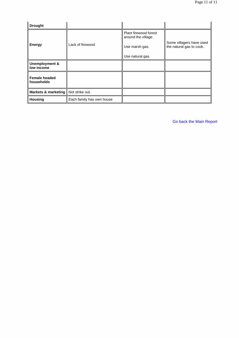
Drought
Energy Lack of firewood
Plant firewood forest around the village.
Use marsh gas.
Use natural gas.
Some villagers have used the natural gas to cook.
Unemployment & low income
Female headed households
Markets & marketing Not strike out.
Housing Each family has own house
Page 11 of 11
Regional Environmental Technical Assistance 5771 Poverty Reduction & Environmental Management in Remote Greater
Mekong Subregion Watersheds project (Phase I)
Annex to RRA Report Xishuangbanna
RRA REPORT OF NANPING NATURAL VILLAGE, MENGLA COUNTY,
XISHUANGBANNA DAI NATIONALITY AUTONOMY PREFECTURE
Watershed Profile
By
Bo Zhou
CONTENTS
1. Description of Surveyed Villages, Size, Location, Main Features of Interest
2. Resource base
3. Land use pattern
4. Land and resource tenure
5. Summary of environmental conditions
6. Demographic features
7. Poverty indicators
7.1 Education
7.2 Housing
7.3 Health
7.4 Employment opportunities
8. Development priorities
9. Conclusions and recommendations for Phase 2
Page 1 of 11

1. Description of Surveyed Villages, Size, Location, Main Features of Interest
Nanping village, a village of Yao Nationality, is located in the southeast of Mengman Township, Mengla County with an altitude of 682m. The road is rough for sugarcane transportation in dry season while only tractors or jeeps can get pass it in rainy season. The villager marches with Shangyong Natural Reserve. The stockade village lies in the hillside with a bigger gradient. The total area of the village is 2156 Chinese mu.
Naping village is a village of hilly region where Yao nationality inhabits. It is located in the experimental zone of Nature Reserve with poor condition and inconvenient communication. In past several years, a large area of forest has been destroyed by deforestation and asserts to plant sugarcane and rubber tree, so soil degradation is very serious and it puts great pressure on natural resources.
Key map of the area
2. Resource base
� Natural forest
The total area of better-preserved natural forest, which is situated on the back of the village, is 469 Chinese mu. The vegetation is monsoon evergreen broad-leaved forest. The appearance of forest is in good order and the vegetation is in a high density. To conserve water source as well as conserve water and soil is the major objective of natural forest.
� Plantations
Page 2 of 11

Since 1994, villagers have planted rubber forest about 656 Chinese mu. The large part of the rubber forest is in no crown closure and soil erosion is serious. In addition, villagers plant 53 Chinese mu firewood forest around the village to solve the shortage of fuel.
� Water supply
The village hasn't tap water. Water is drawn into each family with bamboo tube. Paddy field lies in the ravine of the foot of the hill, where there is no irrigation and water conservancy installations. In every dry season, villagers spend a lot of labour force on constructing temporary irrigation canals and ditches.
� Fisheries
There is no fishpond in the village. There are a lot of small fish in the brook, which is a half-kilometre away from the village. In October and November of each year, villagers catch fish in the brook. As a result of fishing without control, less and less there are fish in the brook. Now, each family can catch fish about 10 kilograms every year.
� Livestock
In 1998, there are 53 buffaloes, 138 pigs and 497 poultry in the village.
3. Land use pattern
� Shifting cultivation
The total area of rotational cultivation land is 188 Chinese mu. Because the rotation period is short, it is difficult for forest to return to normal. The forestland appears degradation condition. With the development of Planting Project, the rotational cultivation land may be cultivated to be dry land.
� Paddy
The total area of paddy field is 79 Chinese mu with a total production of 23383 kilograms. The breeds of planted paddy rice are crossbreed and "201".
� Rubber Forest
Since 1994, 656 Chinese mu rubber trees have been planted. The large part of them are in no crown closure. Rubber trees have been planted along contour line where there is no ground litter and soil erosion is very serious with bad biological diversity.
� Sugarcane Field
The total area of sugarcane is 172 Chinese mu with a total production of 619.9 tons.
� Peanut
The total area of peanut is 30 Chinese mu with a total production of 1250 kilograms.
� Amomum fruit
25 Chinese mu amomum fruit has been planted under the natural forest inside the nature reserve. The total production is 90 kilograms.
Page 3 of 11

4. Land and resource tenure
Land utilisation includes several types following as:
1. Forest land: includes natural forest and man-made forest;
2. Cultivated land: includes paddy field, dry land and shifting field.
For forest land, with the approve of forestry department, the natural forest owned by collective provides firewood and building material, which costs 50 Chinese yuan per cube meter. Meanwhile, man-made forest planted by each family belongs to private property.
For cultivated land, paddy field has been distributed to each family to plant rice when the production responsibility system is applied in 1980s.
Dry land comes from destroyed forestland. In that time, labour force is only restraint factor.
Now, villagers are signing the second round of land contract dating thirty years with government. On the fixed cultivated land, villagers have rights to decide when and what they plant with the government guide. Villager committee stands for the village deciding the utilisation of the collective forest owned by collective.
5. Summary of environmental conditions
� Extent of degradation
Now, except for 548 Chinese mu paddy field and natural forest, all lands appear degradation condition. Most serious degradation is given expression to the sugarcane land, which is located at the hillside and the foot of the hill. Because villagers have cultivated along the slope for a long time without applying fertiliser as well as serious soil erosion every rainy season, the fertility of soil drops and the growth of the sugarcane is poor. Even like this, water and soil conservation measures don't applied when villagers plant rubber trees, so a large number of water and fertiliser has lost before rubber forest is formed. Because rotational period is short (less than five years), it is difficult for soil to return good condition. In shifting field, Eupartorium odoratum and Imperata cylindrica, which are the indicators of soil degradation, have grown.
� Resource and land sustainability
The total area of forest is 522 Chinese mu (not include rubber forest). While the consumption of firewood is eighty cube meter per year, which means the growth quality of forest is less than the consumption of forest. So resources can not be used sustainably.
Man-made rubber forest is single-layer forest with serious erosion and bad continuity.
The gradient of dry land (including shifting field) is bigger. Meanwhile, the backward in technique and poor application of agricultural technology results in soil degradation.
� Planned development structures, roads, dams, etc
The local government has planned to build a dam at the water source to develop planting and deal with farm irrigation. But, because of the lack of fund, it is impossible to carry out now.
6. Demographic features
� Population and growth
Page 4 of 11

There are 20 families and 102 persons in the village. All villagers are Yao Nationality. Among them, there are 54 male and 48 female. Most of families have three generations, five to six persons are general in a family. In 1986, there are 98 persons in the village. Comparing with present condition, population growth is slow. However, many families want to have three children. It can be predicted that population will obviously increase in the future.
� Gender issues
Yao nationality often pays more attention to boys than girls. To have a boy results in the birth out of control serious. Man controls the family. as for as social division of labour is concerned, men lay particular stress on physical labour, while women on household chores. Meanwhile, they do other farm works together.
� Ethnicity and its effect on environmental management and poverty
Yao nationality villagers live in the mountain area. They are mainly engaged in upland agriculture of slash and burn agriculture following the rotation system. The production of upland crops is low and unsteady. The shortage of grains certainly leads to expand the planting area and shorten rotation period, which do great damage to the environment.
Because of low average paddy area, mountain inhabitants often expand the planting area for increasing average income, which inevitably destroys forest and environment.
7. Poverty indicators
7.1 Education
� Current status and opportunity
The village has a lessens-given point. Fourteen kilometres away from the village, there is a complete primary school in Daguang administrational village. The pupils have to go to the middle school of Mengman Township after graduating from primary school.
The enrolled rate of the children suited to go to school is 100%. Among the 102 villagers, one person has senior degree (go out to work), five persons have junior degree, sixty-one persons have primary degree, eighteen persons go to school and eighteen persons are illiteracy.
� Future scenario
A TV satellite receiver, which provides more education opportunities, has been installed in the village recently. Villagers' consciousness of paying attention to education has developed a lot. As a result, they encourage their children to read more books.
7.2 Housing
� Current status
The village is located in the flat area of hillside. There is no tap water in the village and lighting obtained through the small hydropower station in the night. The management bureau of Xishuangbanna Nature Reserve helps each family build brick house, which occupies a total area of 200 square meters. The yard occupying about 1 Chinese mu is very spacious. In addition, there are a 20 square meter wooden storehouse to store the crops and a kitchen of 20 square meters.
Villagers use energy-saving stove to cook hog feeding while use "huotang" to prepare food for them.
Each family has a TV set.
Page 5 of 11

� Future opportunity
They will make efforts to obtain fund to solve the tap water problem, increase the generated energy of the small hydropower station and satisfy with villagers the needs for electricity.
7.3 Health
� Current picture
There is no clinic or doctors in the village. The patient has to go to the Mengman Township Hospital to see doctor, which is 14 kilometres away from the village. If the illness is not very serious, they treat it themselves by herbal medicine collected from the forest.
Because of bad traditional customs, there is no any toilet in the village, which threaten villagers' health. Villagers are easily infected by malaria. Most of people in the village have this kind of germ in their bodies. Every year, about fifteen persons fall ill.
� Future opportunity
With the improvement of living standard and sanitary condition such as drawing tap water, building toilet and curing malaria, the possibility of infection and falling ill will come down greatly.
7.4 Employment opportunities
Few villagers go out to work. Nobody works in enterprise and institutions either.
8. Development priorities
The key problem of Nanping village is farm irrigation. As a result of bad irrigation and water conservancy facilities, the yield of crops is very low. Villagers hope eagerly to obtain fund to build irrigation channel. In addition, because of too small cistern, the generated energy of the small hydropower station just can provide one-hour electricity. So it is necessary to enlarge the reservoir to lengthen the time of generating electricity to satisfy with villagers' needs.
9. Conclusions and recommendations for Phase 2
1. Train villagers in practical agricultural technique;
2. Build irrigation channel;
3. Build bigger reservoir.
Profile Chart of Nanping Village
Page 6 of 11

Nanping Village (Altitude: 800m. Adjacent to the Shangyong Nature Reserve)
Name of Village:
Nanping Village, Mengman Township, Mengla County, Xishuangbanna Dai Autonomous Prefecture
Date: Mar. 31, 1999
Prepared by: Meng Guangtao, Fang Bo, and Dai Yiyuan
In discussion with: Li ruocai, position: Chief of Nanping natural village and with Zhao jinjing, position: Accountant of the village, and with Deng jincai, position: Keeper of the village, etc.
Native language(s) of informants:
Yao language (Chinese while interviewing)
1. Village Location including distances from neChinese mut paved road and from neChinese mut markets town.
Located at the boundary of the Shangyong Nature Reserve. 17 kilometres away from the paved road, the road to the village is rough. The neChinese mut markets town is Mengman Township, 17 kilometres away from the township. 5 kilometres away from the Daguang administrational village
2. Village Population: no. of families (with approximate ethnic breakdown), no. of people including male/female, age groups breakdown, and the number of immigration and out if available to get the trend of population
Population: 107, families: 20, all Yao people, male: 51, female: 56; (the data of 1998) Immigration in: 1, immigration out: none Birth: 1, death: 1
Page 7 of 11
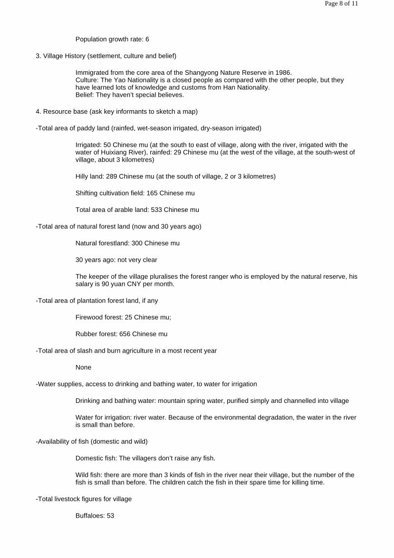
Population growth rate: 6
3. Village History (settlement, culture and belief)
Immigrated from the core area of the Shangyong Nature Reserve in 1986. Culture: The Yao Nationality is a closed people as compared with the other people, but they have learned lots of knowledge and customs from Han Nationality. Belief: They haven’t special believes.
4. Resource base (ask key informants to sketch a map)
-Total area of paddy land (rainfed, wet-season irrigated, dry-season irrigated)
Irrigated: 50 Chinese mu (at the south to east of village, along with the river, irrigated with the water of Huixiang River), rainfed: 29 Chinese mu (at the west of the village, at the south-west of village, about 3 kilometres)
Hilly land: 289 Chinese mu (at the south of village, 2 or 3 kilometres)
Shifting cultivation field: 165 Chinese mu
Total area of arable land: 533 Chinese mu
-Total area of natural forest land (now and 30 years ago)
Natural forestland: 300 Chinese mu
30 years ago: not very clear
The keeper of the village pluralises the forest ranger who is employed by the natural reserve, his salary is 90 yuan CNY per month.
-Total area of plantation forest land, if any
Firewood forest: 25 Chinese mu;
Rubber forest: 656 Chinese mu
-Total area of slash and burn agriculture in a most recent year
None
-Water supplies, access to drinking and bathing water, to water for irrigation
Drinking and bathing water: mountain spring water, purified simply and channelled into village
Water for irrigation: river water. Because of the environmental degradation, the water in the river is small than before.
-Availability of fish (domestic and wild)
Domestic fish: The villagers don’t raise any fish.
Wild fish: there are more than 3 kinds of fish in the river near their village, but the number of the fish is small than before. The children catch the fish in their spare time for killing time.
-Total livestock figures for village
Buffaloes: 53
Page 8 of 11

Cattle: none
Pigs: 138
Chicken: 497
The murrain didn’t occur in recent year due to the villagers injected their livestock and poultry with bacterin when they found the animal were sick.
5. Resource Tenure and Management Incentives
-Is forest state-owned, community owned, or household owned?
250 Chinese mu of forest collective owned, none forest household owned
-What incentives for rapid/pre-emotive extraction of forest resources exist?
Planting rubber at the top of hill.
Planting amomum fruit in the rain forest.
The villagers plant the firewood forest near their village, it can reduce the pressure on the natural forest.
-What incentives for sustainable management of forest resources exist?
Plant the firewood near the village, enlarge the area of the firewood forest.
Most of the natural forests near the village are state own, the villagers are forbidden to lumber in the forest. They can collect deadwood and a few of herbal medicines.
-Describe traditional tenure and management practices and how these may have broken down.
A lot of deforestation while forest ownership not been identification
6. Availability of government/private sector services
-Health service
No clinic rooms in the village, one health workers. There is one toilet in the primary school only, none in the village.
-NeChinese mut school, to what level, use of indigenous languages in primary school
A primary school in the village. Using ‘putonghua’ (standard Chinese pronunciation) in class.
-Veterinary services
There is One veterinarian in administrational village, none in natural village.
The villagers purchase the bacterin to inject the livestock or poultry themselves under the direction of the veterinarian.
-Agricultural extension
None.
-Agricultural credit
Page 9 of 11

None
-Availability of electricity
There is a small dynamotor which use the fall of water to generate 5.5 kilowatt electricity in the village. It is can provide normal electricity for the villagers. The villagers can not only light but also see TV programs.
7. Livelihood Strategies (time may allow only brief coverage of these topics)
-Occupations (by gender, by socioeconomic group)
One female clerk in charge of the family birth control in the administrational village.
-Labour patterns for meeting basic needs (by gender, by socioeconomic group)
Nearly equal, but the women is more toilsome than the man.
-Use and control of resources and benefits (by gender, by socioeconomic group)
Mainly by man.
-Income and expenditure patterns (by gender, by socioeconomic group)
Decided by man.
8. Development Priorities
-Key problems (by gender, by socioeconomic group)
The paddy and hill fields are difficult to irrigated in dry season.
The science and technology knowledge of the villagers is little, and the educational degree is low.
The firewood will be lack in the future.
-Proposed development activities (by gender, by socioeconomic group)
Building a large pond to enhance the capacity of electricity generated.
Build water channel to irrigate the paddy.
-Best Bet Action Plans (by gender, by socioeconomic group)
Credit without interest may be the best or micro credit
Problem Analysis Chart of Xiaonuoyou Down Village
Problems Causes Coping Strategies Opportunities
Health & Sanitation Build toilets in the village
Animal health Not strike out.
Education The children don’t want to learning in school.
Increase the proportion of practical science and technology knowledge in the education.
Page 10 of 11

Go back the Main Report
Erosion Slight, but serious in the sugarcane field
Rotate the sugarcane field.
Water
Lack of irrigation water in dry season
rebuild a dam on the base of the damaged dam which built in 1957.
Many villages will benefit from it.
The local people have a strong will to change their irrigation condition.
Drought
Energy Lack of firewood
Plant fuelwood forest around the village.
Use marsh gas.
Use natural gas.
Some villagers have used the natural gas to cook.
Unemployment & low income
Female headed households
Markets & marketing Not strike out.
Housing Each family has own house
Page 11 of 11

Regional Environmental Technical Assistance 5771 Poverty Reduction & Environmental Management in Remote Greater
Mekong Subregion Watersheds Project (Phase I)
Annex to RRA Report Xishuangbanna
RRA REPORT OF NAXIU NATURAL VILLAGE, MENGLA COUNTY,
XISHUANGBANNA DAI NATIONALITY AUTONOMY PREFECTURE
Watershed Profile
By
Bo Zhou
1. General Description
Naxiu natural village, a village of Aini Nationality, is located inside Mengla Nature Reserve, to the southeast of Mengla County, adjacent to Laos. The management of this village appertains to Jingpiao administrational village, Mengla Township, Menghai County. It is 65km far away from the capital town of Mengla County, where the Mengla Township is located in. The neChinese mut market place is Mengban Township, 28km far away from the village. The road to the village is very rough and wandering. It is difficult to get to the village in rain season by car or by jeep. There is a small river called Napiao River to the south of the village, which is the 3rd level branch of Langcang River (Mekong River).
The village occupies a total area of 3.1 km2. There are 24 households and 144 persons in the village (male: 79, female: 65). The villagers are all Aini Nationality, a branch of Hani Nationality. The annual average revenue of the villagers is just 478 Chinese yuan, lower than the absolute poverty line.
The Aini Nationality is the 3rd nationality in Xishuangbanna Dai Nationality Autonomy Prefecture. Most of them settle in the mountain area, where the communication is very inconvenience. Because the education in the mountain area is very bad, and some villagers can't afford their children to reading in the school, the children have few opportunities of education in their lives.
2. Resource Base
The village has a total area of 25hm2 natural forest, which is collective own. The vegetation of the natural forest mainly belongs to the mountain rain forest. The villagers can collect the non-timber forest product (NTFP) in the forest, such as bamboo shoot, herbal medicine, and wild vegetable, etc.
The villagers haven't plant any trees in the hill or around their village.
There is a small river near the village, which origin is in the territory of Laos. The rate of flow is very small in
Page 1 of 9
dry season. The villagers irrigate their paddy with the water in the river. There are some mountain springs near the village. They channeled the mountain spring water with bamboo into the village to drink for themselves and their livestock.
The villagers' harvesting of fish from the river is about 800kg each year, but the amount is less than before. The male does fishing with net or by blocking up the river to get fish. They don't sale the fish. And they don't raise the domestic fish too.
There are 95 livestock (including 91 buffaloes and 4 horse), 200 pigs, 4 goat and 170 poultry in the village. The villagers plough their paddy with buffaloes. All of these animals are not stable breeding, so the pigs are very thin. The villagers raise their buffaloes in the hills around their village. When they plough their paddy in spring, they look for the animals, find them and drive them home to plough paddy. Livestock murrain often occurred in the village. All the pigs died in 3 years ago. And in 1997, 13 buffaloes died and about 180 pigs infected by murrain.
3. Land use pattern
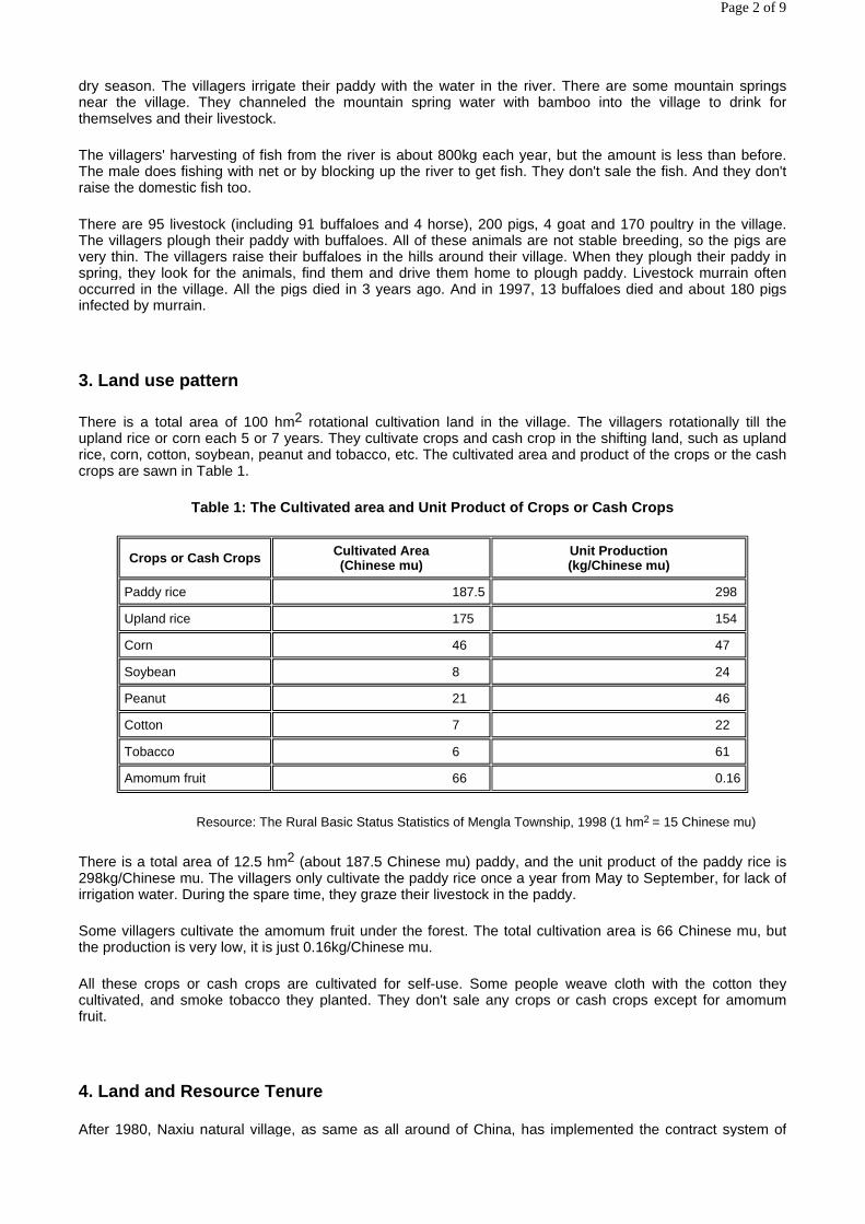
There is a total area of 100 hm2 rotational cultivation land in the village. The villagers rotationally till the upland rice or corn each 5 or 7 years. They cultivate crops and cash crop in the shifting land, such as upland rice, corn, cotton, soybean, peanut and tobacco, etc. The cultivated area and product of the crops or the cash crops are sawn in Table 1.
Table 1: The Cultivated area and Unit Product of Crops or Cash Crops
Resource: The Rural Basic Status Statistics of Mengla Township, 1998 (1 hm2 = 15 Chinese mu)
There is a total area of 12.5 hm2 (about 187.5 Chinese mu) paddy, and the unit product of the paddy rice is 298kg/Chinese mu. The villagers only cultivate the paddy rice once a year from May to September, for lack of irrigation water. During the spare time, they graze their livestock in the paddy.
Some villagers cultivate the amomum fruit under the forest. The total cultivation area is 66 Chinese mu, but the production is very low, it is just 0.16kg/Chinese mu.
All these crops or cash crops are cultivated for self-use. Some people weave cloth with the cotton they cultivated, and smoke tobacco they planted. They don't sale any crops or cash crops except for amomum fruit.
4. Land and Resource Tenure
After 1980, Naxiu natural village, as same as all around of China, has implemented the contract system of
Crops or Cash Crops Cultivated Area (Chinese mu)
Unit Production (kg/Chinese mu)
Paddy rice 187.5 298
Upland rice 175 154
Corn 46 47
Soybean 8 24
Peanut 21 46
Cotton 7 22
Tobacco 6 61
Amomum fruit 66 0.16
Page 2 of 9

crop-yield responsibility, i.e. the contract of farmland using. Every household in rural area has several Chinese mu of farmland, including irrigated field, dry land and some woody-hilly land, which being controlled by farmer. The term of the contract of farmland using is extended for 30 years from 1998. Farmer or villager can plant any kind of crops as his or her wish and gain any profit from the land of responsibility.
5. Summary of Environmental Condition
Because the villagers till their rotational fields once two or there years without using any fertilizers, the period of slash and burn agriculture is shorter than the before, about 580 Chinese mu of shifting land of the village has grown with Eupatorium odoratum and Imperata cylindrica, which are indicators of soil degradation. It is difficult to cultivate any crops in the field. Due to the deforestation, the soil erosion often occurs in rain season. The fertility of the hill land decreased, and the production of the crop decreased too.
6. Demographic features
There are 144 persons in the village. Each family has 3 to 5 children exceeding the permission of family birth control policy. Though the birth rate is high, the population growth rate isn't high for the high mortality. The population growth rate keeps 0.6% during the past 20 years.
The status of Aini nationality female is lower than the male. They haven't the chance of education, and they have to obey the orders of their fathers or husbands in their lives. They are hardship than man, they not only labor as man, but also raise children and looking after the old, do cooking and washing.
Most of Aini people settle at the mountain area, they farm with traditional cultivation method --slash and burn agriculture. For the recovery of vegetation in Xishuangbanna Dai Nationality Prefecture is quicker than in other place in China, if the period of rotation were long enough, for example, more than 7 years, the use of land resource would be sustainable. But now, for the case of population pressure and the policy of natural forest protection, the villagers have to cultivate their shifting land once two or three years. The traditional cultivation method -- slash and burn agriculture isn't sustainable any more.
7. Poverty Indicators
7.1 Education
The education in the mountain area is underdeveloped in China, especially in the remote mountain area. There is an uncompleted primary school in the village. The classroom is simple, there are one blackboard, 6 desks in the room. Only one informal teacher teaches the 12 pupils the courses of Chinese, Maths, and History of China in 'putonghua' (standard Chinese pronunciation). The pupils are all boys, and the girls have no chance to be educated. So, almost all of the women or the girls are illiteracy.
7.2 Housing
The villagers' housing are made of wood, the floor board is scraggy soil. There are little furniture, such as table and stools. There isn't any durable consumer goods or household appliances.
7.3 Health
There isn't any clinic or health worker in the village. The main disease found among the villagers is malaria that is infected by mosquitoes. If they were very sick, they had to go to clinic of Mengban Township or to the hospital in the capital town of Mengla County. The health worker from the clinic of Mengla Township vaccinates the children once a year. Some villagers collect herbal medicine to cure small disease, such as cold, cough and tummy.
7.4 Employment Opportunities
Page 3 of 9

The Aini people consider that it is a disgraceful thing to go out to do odd jobs. On the other hand, they have no chance to work due to their low degree of education.
8. Development Priorities
Naxiu natural village is really an absolute poverty village. There are many problems need to be solved, such as the water supply, health and treatment, electricity, and education, etc. But the important thing is the education, especially the education to the female. Another thing is to solve the water supply condition. A pond should be built to purify the water and piped to the household.
9. Conclusions and Recommendations for Phase II
1. Building a classroom for the pupil;
2. Building a pond and piping the water to the family;
3. Promote the status of women by propaganda and education;
4. Carry out agricultural extension to adopt advanced agricultural technology to promote the yield of crops.
Profile Chart of Naxiu Village
Page 4 of 9

Annex: Checklist for Village Interview
Naxiu Village (Altitude: 1133m, inside Mengla Nature Reserve, adjacent to Laos)
Name of Village:
Naxiu Village, Mengla Township, Mengla County, Xishuangbanna Dai Autonomous Prefecture
Date: Apr. 1, 1999
Prepared by: Meng Guangtao, Fang Bo, and Dai Yiyuan
In discussion with: Jin Baiyang, position: villager and with Ma Gaxiu, position: villager, and with Wang Lansan, position: villager, etc.
Native language(s) of informants:
Aini language (Chinese while interviewing)
1. Village Location including distances from neChinese mut paved road and from neChinese mut markets town.
Located in the Mengla Nature Reserve.
65 kilometers away from capital town of Mengla County, rough road.
The neChinese mut markets town is MengBan Township, 28 kilometers away from the village.
10 kilometers away from the Daguang administrational village
2. Village Population: no. of families (with approximate ethnic breakdown), no. of people including male/female, age groups breakdown, and the number of immigration and out if available to get the trend of population
Page 5 of 9

Population: 144, families: 24, all Aini people, male: 79, female: 65; (the data of 1998) Immigration in: 1, immigration out: none Birth: 1, death: 1 Population growth rate: 6 Village History (settlement, culture and belief) Settled in 1973. The villagers don't intermarry with other people except for their own people lived near their village and in Laos. They adapt the traditional till mode -- slash and burn agriculture. For example, they cut down all the trees in their shifting field and burn off to bald, then dig the soil to cultivate upland rice or corn without fertilization. Belief: They haven’t special beliefs.
3. Resource base (ask key informants to sketch a map)
-Total area of paddy land (rainfed, wet-season irrigated, dry-season irrigated)
Paddy: 187.5 Chinese mu of lowland rice, the product is 298kg per Chinese mu.
Hilly land (including the fallow): 175 Chinese mu of dry rice, the product is 154kg per Chinese mu. 7 Chinese mu of cotton, the product is 22kg per Chinese mu; 21 Chinese mu of peanut, the product is 46kg per Chinese mu; 6 Chinese mu of tobacco, the product is 61kg per Chinese mu; 8 Chinese mu of soybean, the product is 24kg per Chinese mu. 66 Chinese mu of Amomum fruit, the product is very low.
Total area of arable land: 329 Chinese mu
-Total area of natural forest land (now and 30 years ago)
Natural forestland: 25hm2 (273 Chinese mu)
30 years ago: not very clear, more than the present.
-Total area of plantation forest land, if any
None.
-Total area of slash and burn agriculture in a most recent year
144 Chinese mu.
-Water supplies, access to drinking and bathing water, to water for irrigation
Drinking and bathing water: river water, purified simply, burden home with thick bamboo tube
Water for irrigation: river water. Because of the environmental degradation, the water in the river is small than before.
-Availability of fish (domestic and wild)
Domestic fish: The villagers don’t raise any fish.
Wild fish: there are more than 3 kinds of fish in the river near their village, but the number of the fish is small than before. The men catch the fish by using nets or by blocking up the water. They catch 800kg per year.
-Total livestock figures for village
Buffaloes: 91
Cattle: none
Page 6 of 9

Horse: 5
Goat: 4
Pigs: 55
Chicken: 170
Murrain occurred in 1996, many livestock and pigs died. Due to the villagers injected their livestock and poultry with bacterin when they found the animal were sick, the murrain didn't occurr in large-scale.
4. Resource Tenure and Management Incentives
-Is forest state-owned, community owned, or household owned?
25 hm2 of forest collective own. None forest household owned
-What incentives for rapid/pre-emotive extraction of forest resources exist?
Plant Amomum fruit under the galley rain forest.
-What incentives for sustainable management of forest resources exist?
Plant the firewood near the village, enlarge the area of the firewood forest.
Most of the natural forests near the village are state own, the villagers are forbidden to lumber in the forest. They can collect deadwood and a few of herbal medicines.
-Describe traditional tenure and management practices and how these may have broken down.
A lot of deforestation while forest ownership not been identification
5. Availability of government/private sector services
-Health service
No clinic rooms in the village, no health workers.
-NeChinese mut school, to what level, use of indigenous languages in primary school
An uncompleted primary school in the village. Cause the village settled recently, the school is still building. Using ‘putonghua’ (standard Chinese pronunciation) in class.
-Veterinary services
There is One veterinarian in administrational village, none in natural village.
The villagers purchase the bacterin to inject the livestock or poultry themselves under the direction of the veterinarian.
The main disease of the livestock and poultry is murrain.
-Agricultural extension
None
-Agricultural credit
Page 7 of 9

None
-Availability of electricity
None
6. Livelihood Strategies (time may allow only brief coverage of these topics)
-Occupations (by gender, by socioeconomic group)
None
-Labour patterns for meeting basic needs (by gender, by socioeconomic group)
Nearly equal, but the women is more toilsome than the man
-Use and control of resources and benefits (by gender, by socioeconomic group)
Mainly by man
-Income and expenditure patterns (by gender, by socioeconomic group)
Decided by man
7. Development Priorities
-Key problems (by gender, by socioeconomic group)
The paddy and hill fields are difficult to irrigated in dry season.
The science and technology knowledge of the villagers is little, and the educational degree is low.
The firewood will be lack in the future.
The status of women is lower, the girl has no chance to be educated.
-Proposed development activities (by gender, by socioeconomic group)
Building a pond and piping the water to the household.
Building a classroom for the pupils.
-Best Bet Action Plans (by gender, by socioeconomic group)
Credit without interest may be the best or micro credit
Problem Analysis Chart of Naxiu Village
Problems Causes Coping Strategies Opportunities
Health & Sanitation malaria Cure and vaccinate.
Animal health murrain Cure and vaccinate.
The girls have no chance to be educated.
Page 8 of 9
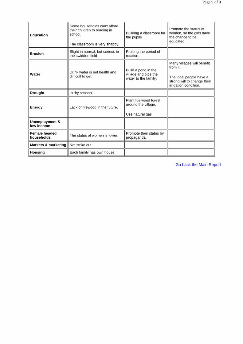
Go back the Main Report
Education
Some households can't afford their children to reading in school.
The classroom is very shabby.
Building a classroom for the pupils.
Promote the status of women, so the girls have the chance to be educated.
Erosion Slight in normal, but serious in the swidden field
Prolong the period of rotation.
Water Drink water is not health and difficult to get.
Build a pond in the village and pipe the water to the family.
Many villages will benefit from it.
The local people have a strong will to change their irrigation condition.
Drought In dry season.
Energy Lack of firewood in the future.
Plant fuelwood forest around the village.
Use natural gas.
Unemployment & low income
Female headed households The status of women is lower. Promote their status by
propaganda.
Markets & marketing Not strike out.
Housing Each family has own house
Page 9 of 9

Regional Environmental Technical Assistance 5771 Poverty Reduction & Environmental Management in Remote Greater
Mekong Subregion Watersheds Project (Phase I)
Annex to RRA Report Xishuangbanna
RRA REPORT OF XIAONUOYOU NATURAL VILLAGE, MENGHAI COUNTY,
XISHUANGBANNA DAI NATIONALITY AUTONOMY PREFECTURE
Watershed Profile
By
Bo Zhou
1. Description of surveyed villages, size, location, main features of interest
Xiaonuoyou Dowm natural village, a village of Lahu Nationality, is located inside Naban River Watershed Nature Reserve. The management of this village appertains to Nuoyou administrational village, Mengsong Township, Menghai County. It is 80km away from the place where the government of Mengsong Township, 85 km away from the capital town of Menghai County, and 40 km away from Jinhong municipality. The neChinese mut market place is Jinhong City, the capital city of Xishuangbanna Dai Nationality Autonomy Prefecture. The road to the village is very rough and wandering. The village occupies a total area of 3539 Chinese mu, including the paddy, hilly land and forest, etc. There are 19 households 86 people in the village. It is 4 kilometers away from the place where Nuoyou administratonal village located.
There is a rough road leaded to the village, and the electricity of the village is normal. But there isn't water supply in the village. The villagers channeled the water from the mountain spring with bamboo tube to the housing. The drinking water is simply purified. All of the fields of the villagers are located inside the Naban River Watershed Nature Reserve.
Because of the history and custom of the Lahu nationality, most of them lived in the hilly regions. Though the area of the villagers' shifting fields is large, they are still poor. And the living status of Lahu people in Xiaonuoyou village can present the Lahu people lived at other places in Xishuangbanna Dai Nationality Autonomy Prefecture.
2. Resource base
� Natural forest
The natural forest of the village occupies a total area of 2336 Chinese mu (155.7ha), among the rest, over 1000 Chinese mu is secondary forest reforested in the shifting fields. The vegetation of 656 Chinese mu original forest belongs to the monsoon evergreen broad-leaved forest, which distributes the back hill of the village; and the vegetation of 680 Chinese mu origin forest belongs to the cleuch rain forest.
Page 1 of 9

� Plantations
There is no man-made timber forest and firewood forest. Villagers have planted 400 pomelo trees for 2 or 3 years. These trees occupy a total area of about 10 Chinese mu.
� Water supply
There is no perfect water supply in the village. The dry land and terraced field are irrigated with rain. The paddy fields are distributed at the foot of hill near the river, irrigated with the river water by channeling simply.
The drinking water is channel to the village with bamboo tube from the mountain spring, which is 1.5 kilometers far away from the village.
� Fisheries
There is no fishpond in the village. But there are some kinds of wild fish in the river near the village. The amount of the fish in the river is few than before.
� Livestock
The sale of livestock is one of the main cash incomes of the villagers. There were 13 yellow cattle, 32 buffaloes and 54 pigs in 1998. Serious murrain occurred in the end of 1998, most of the livestock died for it. There are 5 yellow cattle, 17 buffaloes, 20 pigs and 190 poultry in the village now.
3. Land use pattern
� Shifting cultivation
The shifting cultivated field occupies a total area of 683 Chinese mu. Villagers plant corn and upland rice in it, but the yield is low.
� Paddy
The paddy field occupies a total area of 76.8 Chinese mu.
� Other
Villagers plant some pomelo trees in their dry land.
4. Land and resource tenure
Now, villagers are signing the second round of the land contract dating thirty years with government. On the fixed cultivated land, villagers can decide when and what kind of crops they plant. Without the management of Nature reserve permitting, villagers can not cut any tree except fruit tree planted by them. Since the implement of the protection project of the natural forest, the villagers don't be permitted to cut any living tree. They can collect deadwood as firewood. In addition, villagers cut the firewood in their shifting cultivated field.
5. Summary of environmental conditions
� Extent of degradation
There are about 1683 Chinese mu land, which is found of the soil erosion phenomenon. These lands
Page 2 of 9

are dry land and secondary forestland.
� Resource and land sustainability
The village has big land area and small amount of people. The rotational cultivated period is about 5 to 10 years; the vegetation can renew well during the period. So the use of the forest resource is sustainable.
� Planned development structures, roads, dams, etc
Under the aid and guide of the Management Station of Naban River Watershed Nature Reserve, the villagers have planted some pomelo trees.
6. Demographic features
� Population and growth
There are 19 families, 86 persons (male: 39, female: 47) in the village in 1998. The rate of population growth is 0.6%. Most of the families has 3 children.
� Gender issues
The status of women is equal to the man's. Due to the traditional customs, the education level of women is lower than man's. Women are more toilsome than man. They do not only the household chores but the farm works.
� Ethnicity and its effect on environmental management and poverty
Lahu people follow the traditional cultivation mode-- slash and burn agriculture. The area of paddy is few, and the upland is unfixed. They apply the rotational cultivation system. The area of the rotational cultivated land is large. As the population growth, the consumption of the firewood increases too. The rotation period has been shortened, Eupatorium odoratum, an indicator of soil degradation, grow in the shifting field. So, the slash and burn agriculture maybe a serious threaten to the environment.
The upland crops include upland rice, corn and soybean. Because of the degradation of soil fertility and the backward of agricultural technique, the yield of the crops is unsteady and low. Villagers haven't insufficient food supply.
7. Poverty indicators
7.1 Education
� Current status and opportunity
The children have to go to the uncompleted primary school of Nuoyou administrational village, which is 4 kilometers away from the village. Cause of the far distance and poverty, many families can't afford their children going to high school in the township or in the county. There are 3 persons with junior degree in the village. Most of the villagers have the primary degree. 33 persons are illiteracy.
� Future scenario
The government of Xishuangbanna Dai Nationality Autonomy Prefecture pay more attention on the education. The uncompleted primary school of Nuoyou administrational village will be established as a completed primary school, and applies the 6-year compulsory education to promote the villagers culture degree.
7.2 Housing
Page 3 of 9

� Current status
The housings of ten households are thatched cottages, the housings of 9 households are brickwork. About 80% families in the village have TV set, and about 50% families have sawing machine. There are 3 tractors in the village.
� Future opportunity
The families, who live in the thatched cottages, want to improve their living condition by building brickwork if they have enough money.
7.3 Health
� Current picture
There is no clinic or health worker in the village. The health condition is bad and it is to infect by disease. About 50% villagers are infected by malaria. All the children are injected with immunity bacteria.
� Future opportunity
As the promoting of the living condition and sanitation, the rate of illness will decrease.
7.4 Employment opportunities
There is no villager go out to work.
8. Development priorities
The key problems of the village is following as:
1. The water supply system is bad;
2. The villager's culture degree is low, and the origin of income is few.
3. There is no agricultural extension and the villager's agricultural technique is low.
We, the investigation team, suggest doing some activities to solve these problems. The activities are following as:
1. Building a tap water system;
2. Training the villagers with rural practical agricultural technique;
3. Providing the fruit seedling to the villagers;
4. Credit without interest to the villagers.
9. Conclusions and recommendations for Phase
1. Implement the design and plan of development as soon as possible;
2. Training the fellows who involved in the project.
Page 4 of 9

Profile Chart of Xiaonuoyou Down Village
Page 5 of 9

Xiaonuoyou Down Village (1006m. Above sea level, inside the Naban Natural Reserve)
Name of Village:
Xiaonuoyou Down Village, Mengsong Township, Menghai County, Xishuangbanna Dai Autonomous Prefecture
Date: Mar. 26, 1999
Prepared by: Meng Guangtao, Fang Bo, Dai Yiyuan
in discussion with: Li Zhala, position: Chief of Xiaonuoyou Down Village and with Yang Guangying, position: Accountant of the village, Zhang Sanbao, position: villager, 61 years old, etc.
Native language(s) of informants:
Lahu language (Chinese while interviewing)
1. Village Location including distances from neChinese mut paved road and from neChinese mut markets town.
Located inside the experimental zone of the natural reserve. 40 kilometers away from Jinghong municipality, rough road, the neChinese mut market is Jinghong municipality
4 kilometers away from the administrational village
2. Village Population
No. of families (with approximate ethnic breakdown), no. of people including male/female, age groups breakdown, and the number of immigration and out if available to get the trend of population
Population: 86, families: 19, all Lahu people, male: 39, female: 47;
Above 50 age years old: 7, 18-50 years old year: 36, below 18 years old: 43
Immigration in: 4, immigration out: none
Birth: 2, death: 4
Population growth rate: 6
3. Village History
Immigrated from the old village of Xiaonuoyou Up village about 10 kilometers away in 1991. The old village existed before the liberation of the People’s Republic of China, not very clear. ‘Nuoyou’ in Dai language means ploy-grandsons.
4. Resource base (ask key informants to sketch a map)
-Total area of paddy land (rainfed, wet-season irrigated, dry-season irrigated)
Irrigated: 25.8 Chinese mu (at the south-west of village, along the Naban river, 1 kilometer from the village), rainfed: 50 Chinese mu (at the opposition hills of the village, to the south-west of village, about 3 kilometers)
Hilly land: 97.4 Chinese mu (at the east of village, 1 or 2 kilometers)
-Total area of natural forest land (now and 30 years ago)
Page 6 of 9
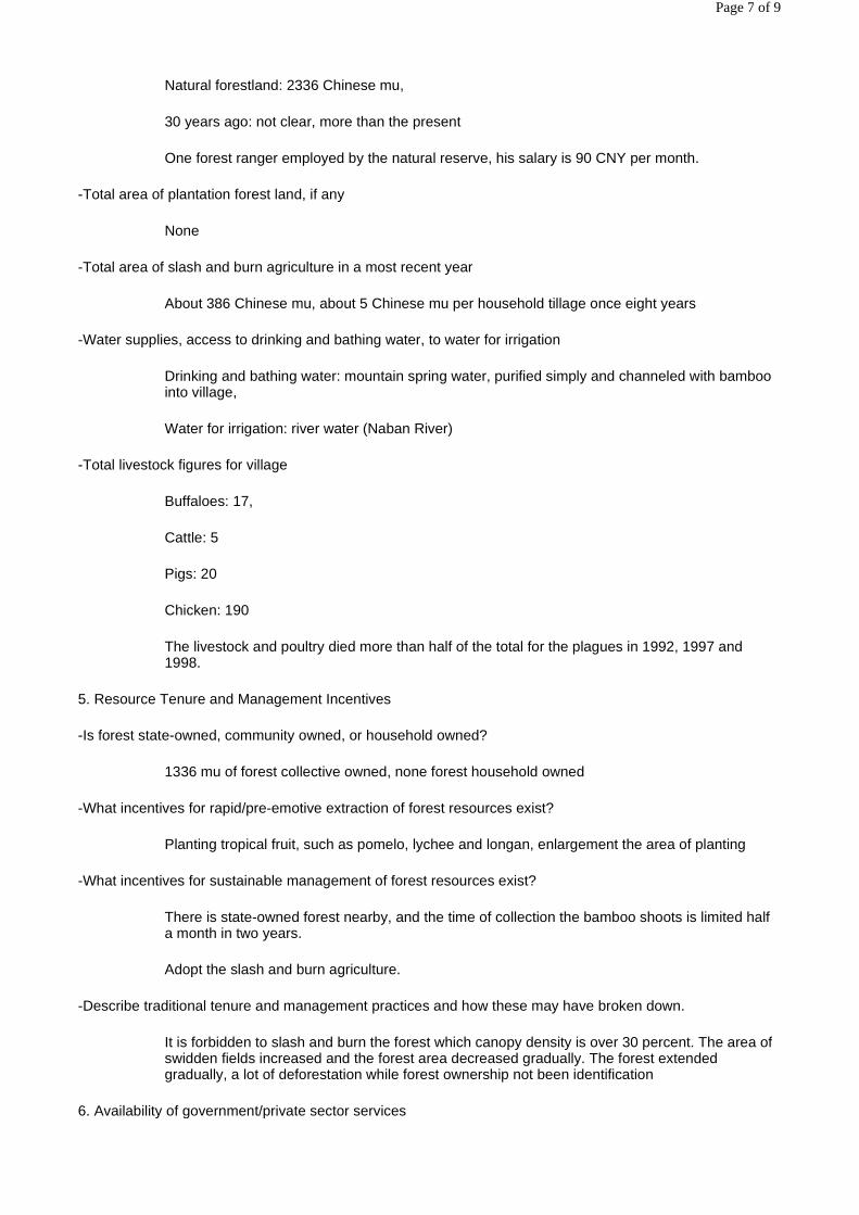
Natural forestland: 2336 Chinese mu,
30 years ago: not clear, more than the present
One forest ranger employed by the natural reserve, his salary is 90 CNY per month.
-Total area of plantation forest land, if any
None
-Total area of slash and burn agriculture in a most recent year
About 386 Chinese mu, about 5 Chinese mu per household tillage once eight years
-Water supplies, access to drinking and bathing water, to water for irrigation
Drinking and bathing water: mountain spring water, purified simply and channeled with bamboo into village,
Water for irrigation: river water (Naban River)
-Total livestock figures for village
Buffaloes: 17,
Cattle: 5
Pigs: 20
Chicken: 190
The livestock and poultry died more than half of the total for the plagues in 1992, 1997 and 1998.
5. Resource Tenure and Management Incentives
-Is forest state-owned, community owned, or household owned?
1336 mu of forest collective owned, none forest household owned
-What incentives for rapid/pre-emotive extraction of forest resources exist?
Planting tropical fruit, such as pomelo, lychee and longan, enlargement the area of planting
-What incentives for sustainable management of forest resources exist?
There is state-owned forest nearby, and the time of collection the bamboo shoots is limited half a month in two years.
Adopt the slash and burn agriculture.
-Describe traditional tenure and management practices and how these may have broken down.
It is forbidden to slash and burn the forest which canopy density is over 30 percent. The area of swidden fields increased and the forest area decreased gradually. The forest extended gradually, a lot of deforestation while forest ownership not been identification
6. Availability of government/private sector services
Page 7 of 9

-Health service
A clinic room, three health workers in administrational village. No clinic room and health worker in natural village
-NeChinese mut school, to what level, use of indigenous languages in primary school
A completed primary school in administrational village, using ‘putonghua’ (standard Chinese pronunciation) in class
-Veterinary services
One veterinarian in administrational village, none in natural village
-Agricultural extension
One agricultural technician in administrational village
A demonstration base of pomelo planting of Xishuangbanna Naban River Watershed Natural Reserve nearby the village
-Agricultural credit
None
-Availability of electricity
Normal
7. Livelihood Strategies (time may allow only brief coverage of these topics)
-Occupations (by gender, by socioeconomic group)
One female accountant in village in charge of economic fair and the statistics of the village, but none at the level of administrative village
-Labor patterns for meeting basic needs (by gender, by socioeconomic group)
Nearly equal
-Use and control of resources and benefits (by gender, by socioeconomic group)
About one third of households by women, two third households by man
-Income and expenditure patterns (by gender, by socioeconomic group)
About one third households decided by women, two third households decided by man
8. Development Priorities
-Key problems (by gender, by socioeconomic group)
to promote the water supply condition
to promote the educated level
-Proposed development activities (by gender, by socioeconomic group)
Page 8 of 9

planting the tropical fruits may be one of development activities
-Best Bet Action Plans (by gender, by socioeconomic group)
credit without interest may be the best or micro credit
Problem Analysis Chart of Xiaonuoyou Down Village
Go back the Main Report
Problems Causes Coping Strategies Opportunities
Health & Sanitation More than half of the adult has been infected by malaria
Animal health Most of the livestock died for the murrain in 1992, 1996 and 1998
Education Some families can’t afford their children to read in the primary school
Not to think of
Erosion Slight, but serious in the swidden field
Water Lack of drink in dry season
Drought When dry year, few occurred
Energy Waste many firewood in the traditional cooking stove to cook the pig’s foodstuff
Should use wood-saving cooking stove or raise the pigs with fresh foodstuff
Unemployment & low income
Female headed households
Markets & marketing Some middleman outside the community come to the village to purchase the bamboo shoots or the watermelon, the villagers can get a few benefit from the bargain
Housing Each family has own house
Page 9 of 9