RPT ON STRIPPING & SAMPLING PROG TIONEGA PROP …
24
42B01SE2005 2.23325 PENHORWOOD 010 REPORT ON THE TIONEGA PROPERTY PENHORWOOD TOWNSHIP PORCUPINE MINING DIVISION STRIPPING AND SAMPLING PROGRAM For Leo Alarie and Sons Limited S.23325 RECEIVED JUL 17 2002 GEOSCIENCE ASSESSMENT _____OFFICE Submitted by: Don T. Fudge Fudge (fe Associates March, 2002 Revised July, 2002 N.T.S. 42B.S.E. 17U 0417886E UTM 5327200 NAD 27
Transcript of RPT ON STRIPPING & SAMPLING PROG TIONEGA PROP …

42B01SE2005 2.23325 PENHORWOOD 010
REPORT ON THE TIONEGA PROPERTY
PENHORWOOD TOWNSHIP
PORCUPINE MINING DIVISION
STRIPPING AND SAMPLING PROGRAM
For
Leo Alarie and Sons Limited
S.23325
RECEIVEDJUL 17 2002
GEOSCIENCE ASSESSMENT _____OFFICE
Submitted by: Don T. Fudge Fudge (fe Associates March, 2002 Revised July, 2002
N.T.S. 42B.S.E.
17U 0417886E UTM 5327200 NAD 27

Leo Alarie and Sons Limited - Tionaga Project
TABLE OF CONTENTS
Page No.
l .0 Introduction 3
2.0 Location and Access 3
3.0 Claim Status 4
4.0 Personnel 4
5.0 Previous Work 4
6.0 General Geology 5
7.0 Work Program 5
8.0 Conclusions and Recommendations 6
9.0 Cost Summary 7
List of Figures
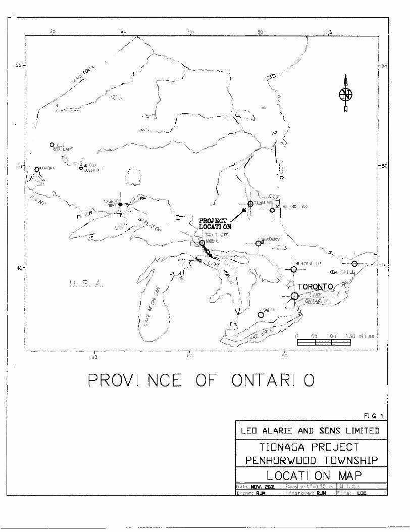
Location Map Figure l
Stripping and Sampling Area Map Figure 2
Appendix
Appendix "A" - Laboratory Test Results
February 2002 Fudge & Associates Page 2 of 8

Leo Alarie and Sons Limited - Tionaga Project
1.0 Introduction
This report deals with the logistics and results of a stripping, mapping, trenching,
sampling and laboratory analysis work program carried out on the "Tionaga Property" in
Penhorwood Township of Leo Alarie and Sons Limited in the Porcupine Mining Division
during the between May and November, 2001.
The Tionaga Property is comprised of 3 unpatented mining claims recorded in the name
of Leo Alarie and Sons Limited, Timmins, Ontario. Overburden stripping, mapping,
drilling, blasting and sampling was carried out under the direction of Fudge *fe Associates
of North Bay, Ontario.
The purpose of the program was to determine if the outcropping & sub-cropping rock
was significantly uniform in composition, and sufficiently chemically and physically
stable to meet rail ballast specifications.
2.0 Location and Access
The property is located immediately adjacent to the C.N.R Tionaga siding in Penhorwood
Township. Road access from Timmins is via Highway 101 West, and then south on the
graveled Penhorwood main road to the C.N.R. main line. The property is 82 km from
Timmins and approximately 2 km east of the Rosevale Silica Mine. The C. N. Rail.
Main line bisects the claim group in an east-west direction. See Figure 2.
February 2002 Fudge *Si Associates Page 3 of 8
™"" X PROJECT X LOCATION
f : -.". { -:
PROVI NCE OF ONTARI O
FI G 1
LED ALARIE AND SDNS LIMITED
TIDNAGA PROJECT PENHDRVDDD TDWNSHIP
LOCATI ON MAPHJH RJM LDC.

Leo Alarie and Sons Limited - Tionaga Project
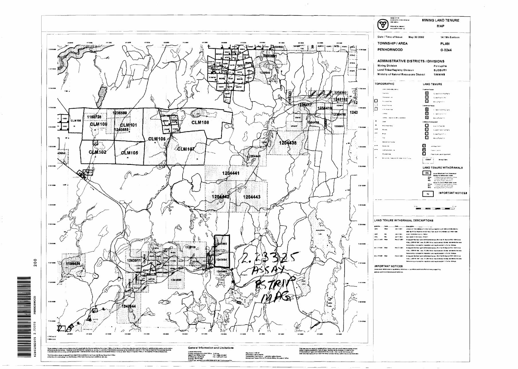
3.0 Claim Status
The Tionaga claim group is comprised 3 contiguous mining claims comprising a total of
10-16.5 ha units each held 10007o by Leo Alarie and Sons Limited, P.O. Box 912,
Timmins, Ontario. The claims are as follows:
Claim
Number
P 1243683
P 1243684
P 1243685
Number of Units
4
4
2
Registered Owner
Leo Alarie and Sons Ltd.
Leo Alarie and Sons Ltd.
Leo Alarie and Sons Ltd.
Interest Held
10007o
10007o
10007o
4.0 Personnel
The following personnel were directly involved with the stripping, and mapping program:
Don T. Fudge
Ray Meilkle
J. Demers
Fudge (fe Associates North Bay, Ontario
Fudge *fe Associates North Bay, Ontario
Leo Alarie and Sons Limited Timmins, Ontario
5.0 Previous Work
There is no evidence of earlier work in the Assessment Files of the Ministry of Northern
Development covering the claim group.
February 2002 Fudge Jt Associates Page 4 of 8

jOf. a C-1
MAGNETIC HIGH AXIS
UTM MAP DATUM - NAD 93
FUDGE &C ASSOCIATES
LED ALARIE and SONS EIMITED
PENHDRVDDD PROPERTY MAGNETIC SURVEY GRID
PQRCIPINE MINING DIVISIDN SCALE 13000
PENHORVEinD TOWNSHIP

Leo Alarie and Sons Limited - Tionaga Project
6.0 General Geology
Rock units underlying Penhorwood Township consist of a complex folded mass of mafic
metavolcanics, pyroclastics and metasediments, cut by mafic, ultramafic, and felsic
intrusives. Granite and granodiorites intrude these units. Late phase northerly trending
Matachewan Diabase Dykes cut all rock units.
Based upon published geological Map 2627 (OGS Report 297, 1995, J. A. Ayer), the
claim group is underline on the north by an 800 to 1000 meter wide mafic metavolcanic
unit trending north 60 degrees east and is thought to be part of the Hardiman Deformation
Zone The southern portion of the property is underline by a granite/granodiorite intrusive.
One or more north trending matachewan diabase dykes intrude the central portion of the
property and are the primary focus of this investigation.
7.0 Work Program
A stripping, mapping and lab work program followed reconnaissance prospecting
undertaken in June 2000. Reconnaissance prospecting confirmed the presence of massive
high-density diabase though to have potential for development of a quarry suitable for
rail ballast production
On May 12 th 13 th and 14l two test locations were stripped using hand tools to expose
bedrock. The test locations were then drilled, blasted and a 50-kilo sample from each
location was packed out and sent to John Emery Geotechnical Engineering Limited in
Toronto for analysis. Sample PH-2001-01 consisted of granodiorite. Sample PH 2002-01
consisted of matachewan diabase. Reference samples were retained at the office of Fudge
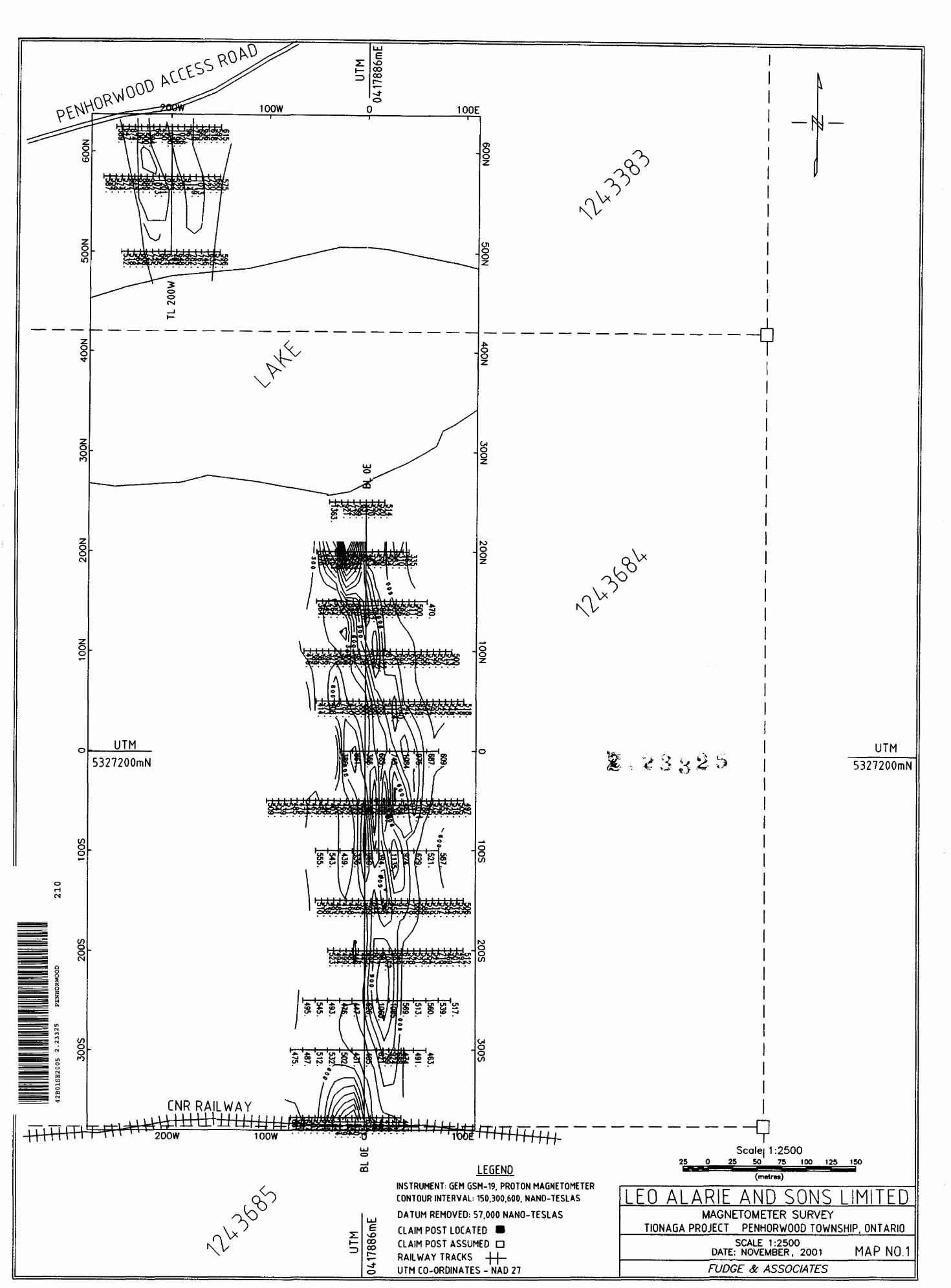
Se Associates in North Bay. On June 11,2001 a test line with a GSM-816 Magnetometer
was completed to determine magnetic susceptibly and resultant potential to use the
magnetic response use as a mapping tool.
A further magnetic survey followed immediately by mechanical trenching, and mapping
was completed in November 2001.
February 2002 Fudge tfi Associates Page 5 of 8

Leo Alarie and Sons Limited - Tionaga Project
The samples were tested and reported for:
* Bulk Relative Density and Absorption M.T.O. LS-604
* Magnesium Sulphate Soundness M.T.O. LS-606
* Mill Abrasion 070 Loss
* Petrographic Examination M.T.O. LS-609
* Micro-Deval Abrasion M.T.O. LS-618
* Loss Angels Abrasion 07o loss
Test Results are listed in Appendix "A"
Based upon initial laboratory analysis which confirmed only marginal suitability of the
Granodiorite sample, a second field program was undertaken to determine the location
and extent of the diabase dykes which passed initial testing.
A Komatsu PC 200 excavator was brought in from Timmins and a limited trenching
program was undertaken. An earlier magnetometer test had identified a magnetic
signature interpreted to be associated with the diabase dyke. The program focused on
further magnetic survey and trenching the magnetic anomaly in an attempt to correlated
magnetic signature with the underlying diabase. Four shallow trenches were dug across
strike over the anomaly to expose bedrock. The trenches were mapped and re-filled.
8.0 Conclusions and Recommendations
Initial testing of two 50-kg samples obtained in May 2001 confirmed that the diabase
sample is the preferred source of rail ballast and the only one of the samples submitted to
meet rail-ballast requirements.
Test showed the granodiorite was susceptible to abrasion and would not meet
specifications. The granodiorite sample returned a LA Abrasion loss of 21.507o, exceeding
February 2002 Fudge *fe Associates Page 6 of 8

Leo Alarie and Sons Limited - Tionaga Project
the 20^0 maximum by l .5 07o. Diabase returned a comparable value of 11 .707o. All other
tests for both samples were within specification limits. Test results are shown in
Appendix "A"
Trenching of geophysical targets confirmed that the magnetic anomaly is coincident with
the diabase dyke(s) and accordingly the magnetic signature associated with diabase is a
useful tool in developing geophysically inferred tonnage, in this case, for this deposit.
Trenching along with the magnetic survey appears to confirm the continuity of a 25 to 30
meter wide diabase zone over a strike length of 200 meters. A second parallel zone of
unknown dimensions approximately 20 meters west of the main showing is indicated.
Due to its close proximity to C.N.'s Tionaga Rail Siding the property is likely suitable for
ballast production. Mineable tonnage should be further confirmed to "proven" prior to a
production decision. Geophysical/geological inferred reserves are estimated at 15,000
tonnes per vertical meter. The main zone is open on the north and south.
9.0 Program Cost Summary
John Emery Geotechnical - Lab S 2,240.58
Fudge SL AssociatesMarch 15, 2002 - Report S 800.00 Dec 31, 2001 - Drill/Blast, Sample Collection 8c Shipment to Laboratory, Reconnaissance Geophysics
514,136.00
Leo Alarie and Sons Limited Nov. 19-23, 2001Float Komatsu B-hoe Timmins to Property206 Km. return S 529.00 Komatsu B-Hoe 26 hrs @ S77.007hr +GST S 2,442.14 Service Truck S 86.82
Total Expenditures 520,234.54
February 2002 Fudge *S Associates Page l of 8
Leo Alarie and Sons Limited - Tionaga Project
I, Donald Thomas Fudge of the City of North Bay, Ontario hereby certify that:
1. I hold a three year Business Administration Diploma from Cambrian College of
Applied Arts in North Bay, Ontario obtained in 1969 and a Bachelor of Arts
obtained from Carleton University in Ottawa in 1974.
2. That I am a Prospector and have been practicing my Profession since 1975 in
Ontario, Quebec, Newfoundland, Manitoba, Alberta, British Columbia, The
United States of America, Jamaica and China.
3. That I have been employed directly with Teck Corporation, Metallgessellshaft
Canada Limited, the Ontario Ministry of Natural Resources and I have been self
employed with Fudge & Associates since 1984.
4. That l have based my conclusions and recommendations contained in this report
on knowledge of the area, my previous experience and on the results of fieldwork
conducted on the property in 2001.
5. I hold no interest, directly or indirectly in this property, nor do I expect to receive
any interest or consideration from this property other than for professional fees
rendered.
Dated at North Bay this 15thlh day of
March, 2002
Don T. Fudge
February 2002 Fudge & Associates Page S of 8

Appendix "A"

i r"*J") r Y*I P^N /^\ 11— 160Bryan Rond,North Bm/, Ontario
Canada P1C1C2
Dtfrriionlink.net Tel: (705) 472-3053 Gel; (705) 494-0890 Fax: (705) 472-9244
May 15,2001
Branislava VujanovicJohn Emery Geotechnical Engineering Ltd. #1, 109 Woodbine Downs Boulevard Etobicoke, Ontario
Tel: 416-213-1060 ext. 225 (B.V. ext 237) Fax:416-213-1070
Reference: Penhorwood Quarry-Rail Ballast Testing: Sample PH-2001-01, PH-2001-03
Dear Sir:
Being shipped today: Two samples, two pails/sample, require the following analysis per requirements:
] . Petrographic Analysis2. L.A. Abrasion3. Magnesium Sulphate Soundness4. Absorption5. Mill Abrasion (for ballast)6. Abrasion Number (calculated for ballast)7. Specific Gravity
Please advise me when the results will be available, fax results as they come available, and call me if you have any questions.
Yours truly
C: Leo Alarie & Sons Limited, Jan Luthe, P.Eng.
200.22.54

raye
JOHN EMERY GEOTECHNICAL ENGINEERING LIMITEDCONSULTING ENGINEERS
#1, 109 Woodbine Downs Boulevard. Toronto. Ontario M9W 6Y1 Telephone: (416) 213-1Q6O Facsimile: (416) 213-1O7O E-Mail: [email protected] www,iegel.com
Fudge Si Associates160 Bryan RoadNorth Bay, Ontario PIC 1C2
July 31, 2001JEGEL Project: 101066Invoice; 2/377
Tel: 705-472-3053 Fax: 705-472-9244
Attention: Mr. Don Fudge
INVOICE FOR PROFESSIONAL SERVICES
Laboratory Testing of a Samples Identified as PH-2001-01 and PH-2001-03 from Penhorwood Quarry.
Laboratory Testing of [JEGEL #4556, 4776] Sample Crushing and Preparation
Bulk Relative Density Se Absorption
Magnesium Sulphate Soundness
Petrographic Examinations
Los Angeles Abrasion
Mill Abrasion
4 hours @
2 @
2 @
2 @
2 @
2 @
TOTAL THIS
8RT.)
S 46.00
S 55.00
S 225.00
S 225.00
S 175.00
S 275.00
Subtotal GST
INVOICE
S 184.
110.
450.
450.
350.
550.
S 2,094. 146.
00
00
00
00
00
00
00 58
S 2.240,68l
ffi(This total includes S146.5 8 GST. Our GST Number is 102687118RT.)
Notes. I.Net 15 days from receipt of this Invoice, i VzVo per rnomh (i9.6yo per annum)surcharge on overdue accounts.
2. We appreciate the opportunity to be of service and trust this Invoice is in order.
ci
ISO 9001Engineering 7 Research 7 Development 7 Education
Soil 7 Rock 7 Aggregates 7 Slags 7 Asphalt 7 Cement 7 Concrete 7 ByproductsJEGEL* PAVMATEC

JOHN EMERY GEOTECHNICAL ENGINEERING LIMITEDCONSULTING ENGINEERS
#1, 10Q Woodbine Dcwum* Boulevard. Toianco. Ontario MOW 6Y1 loiephone [416J Slfl-IDfin FHnwmiU. f416) S13-1D/CJ t Mail |sgeUPcorrrf:bUn rfvwjcgel.com
FACSIMILE COVER
TO: Don FudgeFadco &L Associates
.IFGFX: 101066 JECEL m#: 004556 Facsimile-: 705-472-9244
FROM: Branislava Vujanovic
DATE: May IS/01
FACIES: 2 (Including this cover sheet.)
\1ESSA(jK.: Los Angeles Abrasion Testing
ORIGINAL: -Not Sem
Don,
Here is Table l with the I..os Angeles abrasion lest results for the two samples labelled as
Pil-2001 -01 and PH-2001-03.
TABLE l LOS ANGKJ-FS ABBRASTON TEST RESL'LTS
TEST
,os Annclcs Abrasion, 'Vo Loss
TEST RESULT
PH-2001-01
2!.5
PH-7001
11.7
MO'I'F.: //"jw" /'"i1* rtfceiwd this facsimile in vrror ptw\t: notify us immediately and return thisfucMttti/e tu us by mail without making a copy. This fQGSlmifo i\ intended only for the adarea&tte, may be subject to privilege oy contain cMnfidential information or hath.
ISO 9001Engineering / Rasiarch / Developmartt x Education
Boil / Rock / Aggr&oatBS / Slags X Asphalt / Camant / Concrete f ByproductsJEGEL* PAVMAFEC

JEGEL101066
TABLE l AGGREGATE PHYSICAL PROPERTIES TEST RESULTS
TEST
Bulk Relative Density
Absorption, 'V0
Sample
Control
Sample
Control
Hot Mix Surface Treatment and Concrete Petrographic Number
Los Angeles Abrasion, V0 Loss
Magnesium Sulphate Soundness, "/o Loss
Sample
Control
Mill Abrasion, QA Loss
TEST RESULT
PH-2001-01
2.651
1 PH-2001-03
2,966
2.676
0.43 0.25
0.68
101
21.5
2.0
....
103
1L7
2,8 1
11.5
2.81 4.81
ISO (J001cl com

RECEIVEDJUL 17 2002
GEOSCIENCE ASSESSMENT OFFICE
Tionaga Property Penhorwood Township
May 2001 trenching and blastingStripping with hand tools, drill blast pack samples
June 2001
November 2001
Magnetometer survey (RJM) Geometrics G-816 (DTF RJM - test of several lines to establish suitability of magnetics as a tool.
Magnetometer, Mechanical Trenching 8z, stripping, mapping

MINISTRY OF NORTHERN DEVELOPMENT AND MINES
Transaction No:
Recording Date:
Approval Date:
C)ient(s):
159410
Survey Type(s):
W0260.00589
2002-MAR-19
2002-JUL-18
Work Report Summary
Status: APPROVEDWorkDonefrom: 2001-MAY-13
to: 2001-NOV-23
LEO ALARIE AND SONS LIMITED
ASSAY MAG PSTRIP
Work Report Details:
Claim#
P 1243683
P 1243684
P 1243685
External Credits:
Reserve:
Perform Applied Perform Approve Applied Approve Assign
32,538 32,123 56,400 56,400 SO
322,838 619,106 36,400 36,400 37,062
SO 30 33,200 33,200 SO
325,376 521,229 516,000 516,000 57,062
SO
35,229 Reserve of Work Report* W0260.00589
35,229 Total Remaining
Assign Reserve Approve Reserve Approve Due Date
0 50 50 2006-DEC-04
7,477 39,376 35,229 2006-DEC-04
0 SO SO 2006-DEC-04
37,477 59,376 35,229
Status of claim is based on information currently on record.
42B01SE2005 2.23325 PENHORWOOD 900
2002-Jul-25 16:23 McAuleyJ Page 1 of 1

Ministry ofNorthern Developmentand Mines
Date:2002-JUL-19
Ministere duD^veloppement du Nord et des Mines Ontario
GEOSCIENCE ASSESSMENT OFFICE 933 RAMSEY LAKE ROAD, 6th FLOOR SUDBURY, ONTARIO P3E 6B5
LEO ALARIE AND SONS LIMITED BOX 912TIMMINS, ONTARIO P4N 7H1 CANADA
Tel: (888) 415-9845 Fax:(877)670-1555
Dear Sir or Madam
Submission Number: 2.23325 Transaction Number(s): W0260.00589
Subject: Approval of Assessment Work
We have approved your Assessment Work Submission with the above noted Transaction Number(s). The attached Work Report Summary indicates the results of the approval.
At the discretion of the Ministry, the assessment work performed on the mining lands noted in this work report may be subject to inspection and/or investigation at any time.
The revisions outlined in the Notice dated June 04, 2002 have been corrected. As well, your request to adjust the assessment credit for this submission has been incorporated into the final approved assessment dollar value. Accordingly, assessment work credit has been approved as outlined on the Distribution of Assessment Work Credit sheet attached. The confidential documents that you supplied to address the items in the 45 Day Notice have been destroyed as you had requested.
If you have any question regarding this correspondence, please contact STEVEN BENETEAU by email at [email protected] or by phone at (705) 670-5855.
Yours Sincerely,
Ron GashinskiSenior Manager, Mining Lands Section
Gc: Resident Geologist
Don Thomas Fudge (Agent)
Leo Alarie And Sons Limited (Assessment Office)
Assessment File Library
Leo Alarie And Sons Limited (Claim Holder)
Visit ourwebsite at http://www.gov.on.ca/MNDM/LANDS/mlsmnpge.htm Page: 1 Correspondence 10:17295
O O CN
taM
OCD
G*n*ra' Information And LlniiUllon*eritirt*!.:
I.MRWKI Hgi;grf*i*'oniiii i m ti*g
OH PIE
PftDVIHTMI. HMHIO
RFC DRM RV w ria
MINING LAND TENURE
MAP
Date l Tim c of Issue May 30 2002
TOWNSHIP y AREA
PENHORWOOD
14:18h Eastern
PLAN
04244
ADMINISTRATIVE DISTRICTS l DIVISIONSMining Division Porcupln* Land Titlo/Rcgistry Division SUDBURY Ministry of Natural Resources District TIMMINS
TOPOGRAPHIC
p z1.";* a ir..r.
LAND TENURE
Q O QQ H,.,,,,M, :
S ^i V-1* * i-"', 1* "~ f
E B[J
1 l J WIT * hi, in C Mn
LAND TENURE WITHDRAWALS
|L ffi1* f lieiiWUidrowifiBiri DIVMIBUUH
Ojutr V Cuvrcl Wthni wwl Typtc
IMPORTANT NOTICES
LAND TENURE WITHDRAWAL DESCRIPTIONS
l 11 IftHI -tltC.ja.HU 11'/*l 3 H.fl 1
* W-LL JMlfll OMT. He*. 11.2001 Nan. bita kniint wy eh ttV rif^miti Bil B trinHtMiwurvEDMdfri i*wMkrit *m m^i ki nbjul Lil PiMlHP than HI.
* A4.L f WIT* l ON L No*. *t 2WH Hoi* HIM Utard wv eh li* riprMvrtt m* AI
l Pi S* w/tm Nm i l 2001 Hiiiiq end tart K* nahii itMbnriMil 4.(imn M ofihi Minh* *-rlB*0 ifv?0rd" H LL-2DQ1 VI Cm T. Mn 31, 2DD1 HDlrttH VDVM vy tBi^/^l OMKI M Jl
IMPORTANT NOTICESi*(1fcHif VMM 1*1 i* *IWTI nnnnai proi^f rt
riofcmi aibrimlnaml *
Thi lifb,,nanun .huwn li tmMt hamri (hi Urn at downlaidliig ft nin.lH* Mlnl*by
CNR RAILWAY
-N
UTM5327200mN
CO CO
LEGENDINSTRUMENT: GEM GSM-19, PROTON MAGNETOMETER CONTOUR INTERVAL; 150,300.600, NANO-TESLAS
DATUM REMOVED: 57,000 NANO-TESLASCLAIM POST LOCATED m CLAIM POST ASSUMED D RAILWAY TRACKS -|-(- UTM CO-ORDINATES - NAD 27
25Scale] 1:2500
25 50^^75^ 100 125 150•^S^HS^™ (metres)
LEO ALARIE AND SONS LIMITEDMAGNETOMETER SURVEY
TIONAGA PROJECT PENHORWOOD TOWNSHIP. ONTARIOSCALE 1:2500
DATE: NOVEMBER, 2001 MAP N0.1
FUDGE: # ASSOCIATES

CNR RAILWAY
MD 00 00
LEGENDCLAIM POST ASSUMED G RAILWAY TRACKS -|-|-
GROUND MAGNETIC CONTOURS ^- -
CONTOUR INTERVAL: 150.300.600. NANO-TESLAS
6ACKHOE TRENCH CMATACHEWAN DIABASE
GRANODIORITEGEOLOGICAL CONTACTGEOPHYSICAUY INFERRED CONTACT
UTM CO-ORDINATES - NAD 27
25Scale 1:2500
25 50 75 100 125 150
(metres)
EO ALAR E AND SONS L M TEDTRENCH LOCATION l GEOLOGICAL MAP
TIONAGA PROJECT PENHORWOOD TOWNSHIP. ONTARIOSCALE 1:2500
DATE: NOVEMBER, 2001 MAP N0.2
FUDGE to ASSOCIATES

E\0 00 00
100W 100E
o o10
l l l l l l? l ) ? t l t M l l l
o o
O O CM
O O
CO O O
(f.
CN
K
tin l l l ITTH
DRILL/BLAST LOCATION SAMPLE NO. PH 2001-03 2m X 2m TRENCH GApBRO
V
l ) l l l M l H
i
H-H-
.. iv.v
I l l l l l l l l#j
UTM5327200mN
DRILL/BLAST LOCATION SAMPLE NO. PH 2001-01 2m X 3m TRENCH MEDIUM GRAINED FELStC VOLCANIC
l l I+-H H-4-H-f-f4-4'4
l l H H l l
1 1 1
t—t—l—l—h
l—l—l—l—h
CNR RAILWAY
1 1 1 1 1 1 1
;f. l l l l l l l—l
.H l l l l l l l l l l l
l l l t l l l
,*SS:5:Sx? ' "'"**-*H—f 4—l
tt l li l M l l l
H—l—l—l—l
•z.
2
D
O Oto
OJ
8LO
42B01SE2005 2.23325 PENHORWOOD ?OO CO
LEGEND
CLAIM POST ASSUMED D RAILWAY TRACKS
HANDSTRIPPED TRENCH
DRILL/BLAST SAMPLE LOCATION1
MATACHEWAN DIABASEGRANODKJRfTEGEOLOGICAL CONTACT fg" j j'GEOPHYStCALLY INFERRED CONTACT *
UTM CO-ORDINATES - NAD 27
-N-
UTM5327200mN
Scale 1:250025- P ^5 50 75 100 125 ISO
(metm)
LhU ALARIF AND SON^ l IMITFHDRILL/BLAST * SAMPLE LOCATIONS
——TIONAGA PROJECT PENHORWOOD TOWNSHIP. ONTARIOSCALE 1:2500
DATE: NOVEMBER. 2001 MAP NO.3
FUDGE to ASSOCIA TES
c
O O
(f) O O
o*J*CN
8os w o
COo oCM
toO O
ta m
100E
M l l l l l l l l M
l l l l l M l ? l l l l l l l j
V
1111 f
UTM5327200mN
l i l l l l l
linn
TRENCH
T:iiT'1 l l l l l l t l l l l
TRENCH #3
n t i i n i 1 1 i i i i i i
i — t — i — i —
^:^:v,Y.Y.y.:;
^vXvX-Xvlv/Xv"*
aiSffiiffii- i ...|-
i i i r-t-H
H — 1
TRENCH tt2 2
CNR RAILWAY
200W 100W
o
\
-N
l l
CJIOo
O
o
•sV!o
E\D OO 00
LEGENDCLAIM POST ASSUMED D RAILWAY TRACKS -|-(-
BACKHOE TRENCH C MATACHEWAN DIABASE GRANODIORITE GEOLOGICAL CONTACT f
OUTLINE OF DETAIL GEOLOGICAL/ TRENCH MAP 1:500
UTM
5327200mN
Scale 1:250025 50 75 100 125 150
(metres)
GEOPHYSICALLY INFERRED CONTACT mmmiziMMmm*
UTM CO-ORDINATES - NAD 27
EO ALARIE AND SONS LIMITEDBACKHOE TRENCH LOCATION i GEOLOGY
TIONAGA PROJECT PENHORWOOD TOWNSHIP, ONTARIOSCALE 1:2500
DATE: NOVEMBER, 2001 MAP NO.4FUDGE Se ASSOCIATES

GRANODIORITE
Fine Grained Dioabase Sharpe contact with Granodiorite. Gram size increases towards center
of dike.
GRANODIORITE
GRANODIORITEGRANODIORITE
17U 0417887mE UTM 5327155mN
GRANODIORITE
Fine Grained Diabase
17llini178i89mE
UTMS327185mN
GRANODIORITEGRANODIORITE
GRANODIORITE
GRANODIORITE
Fine Grained DioabaseSharpe contact with Granodiorite
GRANODIORITE
Diabase17U 0417883mE
GRANODIORITE
GRANODIORITE
O O
l
- O
o o00
I\J o o00
EEGEND 25 O
BACKHOE TRENCH MATACHEWAN D ABASE GRANODORTEGEOPHYSCAELY NFERRED CONTACT
r
UTM CO-ORD NATES - NAD 27
42B01SE2005 2.23325 PENHORWOOD 250
ft i * • v i'.'v T^ J ̂ r^
25
bca e50 75 100 125 150
(meters)
\A
DETA LED GEOLOG CAL/TRENCH MAPTIONAGA PROJECT PENHORWOOD TOWNSHIP. ONTARIO
SCALE 1:500 DATE: NOVEMBER, 2001 MAP NO. 5
FUDGE 8c ASSOCIATES