Rozelle and Blackwattle Bays Maritime Precincts...for associated maritime activities that are...
82
www.waterways.nsw.gov.au forward Master Plan Rozelle and Blackwattle Bays Maritime Precincts Waterways Authority
Transcript of Rozelle and Blackwattle Bays Maritime Precincts...for associated maritime activities that are...

www.waterways.nsw.gov.au
forward
Master PlanRozelle and Blackwattle Bays Maritime Precincts
Waterways Authority
How to use this PDFNavigation:
Bookmarks have been set up in this document for ease of navigation. To view bookmarks, press “F5” on you keyboard.The bookmarks will appear in the window to the left of the document.
Alternatively, you can move from page to page by pressing the “page up” and “page down” key on your key board or by clicking on the navigational buttons located bottom right of the page with the mouse.
Zoom:
To increase the size of the page, go to “view” on main menu and click on the “zoom in” or “zoom out” option.Alternatively, by clicking on the zoom to field in this menu, you can elect a specific size.
Printing:
Go to “file” on the main menu and select print option.
back forwardMaster Plan for Rozelle and Blackwattle Bays Maritime Precincts

back forward
Master Plan for Rozelle and Blackwattle Bays Maritime Precincts back forward
1.1 Introduction 1
1.2 The Sites 2
1.3 History 3
1.4 The Role of the Master Plan 5
1.5 Planning Context 6
1.6 Industry and Community Consultation 7
1.7 Accompanying Documents 8
2.1 Site Vision 9
2.2 Land Use 10
2.3 Views, Built Form and Urban Design 13
2.4 Ecologically Sustainable Development Principles 43
2.5 Access and Circulation 49
2.6 Landscapes 52
2.7 Heritage 67
2.8 Outdoor Advertising and Signage 69
2.9 Utilities and Infrastructure 71
2.10 Implementation and Phasing 72
Figure 1: Master Plan Area 5
Figure 2: Land Use Zones 6
Figure 3: Major Land Use Precincts 10
Figure 4: Major Boat Repair Precinct (Site R1) 11
Figure 5: Maritime Operations Precinct (Site R2) 11
Figure 6: Commercial & Recreational Boating Precinct (Sites R3, R4, R5) 11
Figure 7: Marine Contracting Precinct (Sites R6, R7, R8) 12
Figure 8: Marine Heritage Precinct (Site B1) 12
Figure 9: Commercial Boating Precinct (Sites B2, B3) 12
Figure 10: Visual Catchment 13
Figure 11: Building Height Limits – Rozelle Bay 24
Figure 12: Rozelle and Blackwattle Bay – Sections A-A, B-B, M-M 25
Figure 13: Rozelle Bay – Sections C-C, D-D, E-E 26
Figure 14: Rozelle Bay – Sections F-F, G-G, H-H, I-I 27
Figure 15: Rozelle Bay Site R1 28
1.0 Background
Contents
2.0 Master Plan
List of Figures
back forward
Figure 16: Site R1 – Urban Design Controls 29
Figure 17: Rozelle Bay Site R2 30
Figure 18: Site R2 – Urban Design Controls 31
Figure 19: Rozelle Bay Site R3 32
Figure 20: Sites R3, R4, R5 – Urban Design Controls 33
Figure 21: Rozelle Bay Site R4 34
Figure 22: Rozelle Bay Site R5 34
Figure 23: Rozelle Bay Site R6 35
Figure 24: Sites R7, R8 – Urban Design Controls 36
Figure 25: Rozelle Bay Site R7 36
Figure 26: Rozelle Bay Site R8 37
Figure 27: Rozelle Bay Site R9 38
Figure 28: Public Boating Facilities Opportunity 38
Figure 29: Rozelle Bay Site R10 39
Figure 30: Blackwattle Bay Site B1 39
Figure 31: Sites B1, B2, B3 – Urban Design Controls 40
Figure 32: Blackwattle Bay – Sections J-J, K-K, L-L 41
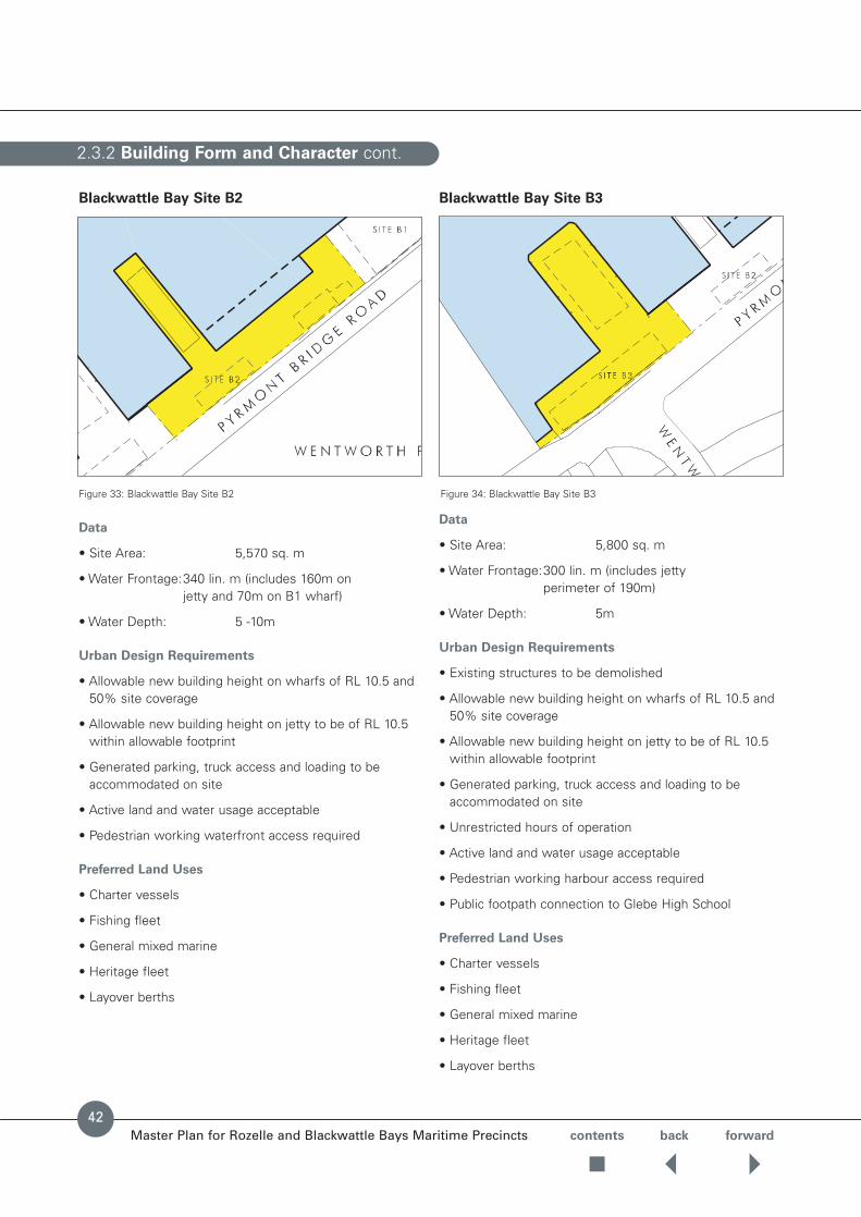
Figure 33: Blackwattle Bay Site B2 42
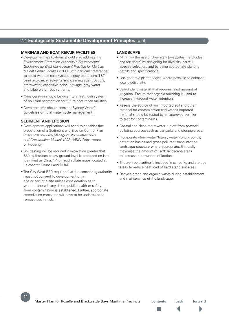
Figure 34: Blackwattle Bay Site B3 42
Figure 35: Roads, Easements, Setbacks and Access 51
Figure 36: Landscape and Public Domain 55
Figure 37: Landscape and Public Domain 56
Figure 38: Landscape and Public Domain Detail – Major Street 58
Figure 39: Landscape and Public Domain Detail – Minor Street 59
Figure 40: Landscape and Public Domain Detail – 24 hour Public Access 60
Figure 41: Landscape and Public Domain Detail – Restricted Public Access 61
Figure 42: Landscape and Public Domain Detail – Public Access Through Site 62
Figure 43: Landscape and Public Domain Detail – Public Access Street Edge 63
Figure 44: Landscape and Public Domain Detail – Blackwattle Bay Street Edge 64
Figure 45: Adaptive Reuse of Coal Bunker Structures 67
List of Figures
Appendices
Master Plan for Rozelle and Blackwattle Bays Maritime Precincts
Contents
Appendix A – Development Proposals spanning Land and Water at Blackwattle and Rozelle Bays 74
Appendix B – Objectives of the Waterfront Use Zone under the City West REP 75
Appendix C – Public Domain Technical Standards 76

The wharves of Rozelle and Blackwattle Bays are a vitalworking part of Sydney Harbour, continuing the strongmaritime traditions of the local area. The WaterwaysAuthority intends to maintain its sites at Rozelle Bay and Blackwattle Bay for maritime industrial uses and for associated maritime activities that are Harbour-related such as the waterfront construction industry and charter/cruise boat servicing.
In November 1997, the subject sites were incorporatedinto Sydney Regional Environmental Plan No. 26 – City West(City West REP) as part of the Bays Precinct. The CityWest REP retains the Bays Precinct as working waterfrontfor port and other maritime purposes by ensuring theforeshore is zoned for these uses and requires thepreparation of a Master Plan for the sites.
The Master Plan is designed to set the program andprinciples for the future rejuvenation of the maritimeprecinct at Rozelle and Blackwattle Bays. Figure 1 shows the area covered by the Master Plan.
Elsewhere, Sydney Harbour’s industrial waterfront sitesare under intense pressure for redevelopment with thedemands of high value residential and commercialinterests competing with the demands of traditional and new working waterfront operations.
As Sydney’s growth continues, arising demands for itsforeshores include:
• Loading and berthing facilities for marine contractorswho repair and maintain wharves, bridges and othermarine facilities;
• The repair and maintenance of working and recreationalboats with many councils restricting repair operationsnear residential areas;
• Additional charter vessel facilities required with increasedtourism;
• Continued gentrification of inner harbour front suburbsresulting in the growth of recreational boating anddemand for land and water storage facilities;
• Additional berthing facilities for working and commercialvessels displaced from other parts of the Harbour;
• Facilities for the heritage fleet;
• Shipwright, chandlery and refuelling facilities;
• Berthing, maintenance and servicing of large visitingrecreational yachts;
• Continued areas for public boating and rowing clubs,some of which have a long history on the waterways of Sydney Harbour; and
• Additional public foreshore access and open space.
1.1 Introduction
Master Plan for Rozelle and Blackwattle Bays Maritime Precincts
Background
contents back forward
1

contents back forward
The Master Plan for Rozelle and Blackwattle Bay coverstwo waterfront sites with an already rich and diversehistory of maritime and industrial activities. Both sites have the benefit of immediate access to major arterialroads and combined with their inner-harbour location andextensive waterfrontage continue to represent prime sitesfor maritime and maritime-related uses. The majority of the land within the Master Plan area is owned by theWaterways Authority.
The Rozelle Bay site is the larger of the two and extendsalong the northern foreshore of Rozelle Bay from the oldGlebe Island Bridge in the east, swinging around south of Whites Creek and terminating at the western edge ofBicentennial Park, east of the Light Rail viaduct. VictoriaRoad and The Crescent extend along the northernboundary. James Craig Road traverses the site from The Crescent to the Glebe Island Dockyard area. Much of the Rozelle Bay site is reclaimed and a piled wharfextends along a major portion of the waterfrontage.
The major developments surrounding the site are eithermaritime (White Bay and Glebe Island port facilities) orindustrial (Rozelle marshalling yards and White Bay powerstation). Residential and open space uses dominate on the opposite foreshore of Rozelle Bay.
The Blackwattle Bay site is located at the head ofBlackwattle Bay between the Pyrmont Peninsula and the foreshores of Glebe. The site is irregularly shaped and is bounded by Pyrmont Bridge Road and BlackwattleBay. It is approximately 1.3 hectares in area, part of whichis reclaimed land and the balance, wharf structures built onpiles over submerged land. Glebe High School isimmediately south-west of the site and the Sydney Fish Markets immediately north-east. Wentworth Park lies directly opposite, separated from the site by PyrmontBridge Road. The major developments surrounding the siteare maritime, commercial/retail (Fish Markets), special uses and open space.
The sites have a total area, excluding road easements andopen space, of 113,000m2. The Rozelle Bay site has anarea of 95,700m2 whilst the Blackwattle Bay site has anarea of 14,300m2.
1.2 The Sites
Master Plan for Rozelle and Blackwattle Bays Maritime Precincts
Rozelle Bay site from Anzac Bridge southern pylon Blackwattle Bay site from Anzac Bridge southern pylon
2

contents back forward
Rozelle and Blackwattle Bays have a long history ofwaterfront maritime activity extending from the early1830’s and are an important element of Sydney Harbour as they are amongst the few remaining bays that continueto be actively used for maritime and waterfront facilities.
18th Century
The areas surrounding Johnstons Bay (including White,Blackwattle & Rozelle Bays) were let in grants to notablessuch as George Johnson of Annandale, William Balmainand the Rev Richard Johnson at the end of the 18thcentury and the early 19th century. Some subdivision did occur in Glebe in 1828 and buyers were wealthySydney notables attracted to waterside locations.
19th Century
Noxious industries, forced out of Sydney Town, began tolocate in the area from the 1830’s and included tanneries,copper smelting, pig yards and tobacco works. The mostsignificant were the Glebe Island Abattoirs in the 1850’s,which further attracted industries such as soap factoriesand candle makers. The Government Abattoirs were aheavy source of pollution within the Bays and by the1870’s local protests led to a Commission of Enquiry in 1879 and petitions by 1887 for its closure and relocation to Homebush.
1.3 History
Master Plan for Rozelle and Blackwattle Bays Maritime Precincts3

contents back forward
Major land reclamation occurred in the later nineteenthcentury for industrial sites and for recreational areas. Land reclamation also created deeper water berthsreplacing early jetties such as those along Rozelle Bay. The foreshores were also developed for industrial uses in the late 1890’s including Langdon and Langdon’s SawMill, Lever Brothers Soap Factory and the Sunlight Oil Works.
At Blackwattle Bay, the head of Blackwattle Bay wasknown as Black Wattle Cove or Swamp. The perimeter of the bay was used for abattoirs and boiling down worksfrom the 1830s to 1860s. Infilling of the swamp and creekoccurred in 1876 with the aim of eliminating the noxioussmells associated with the removal of the pollutingindustries from the area.
Construction of Wentworth Park commenced in 1882.During World War I, the park was utilised for timber sheds and wool stores. Landscape elements such as the lakes and the northern sports ground were removed.The railway which crosses the park was built in 1916.
20th Century
Industrial development of the bays was further supported bythe construction of the existing Glebe Island Bridge in 1901and rail tracks through Rozelle linking to Pyrmont and DarlingHarbour in 1919. In 1926, the Sydney Harbour Trust builtextensive wharfage for timber shipment together with railconnections. Reclamation of mangrove swamps on RozelleBay in 1908 created land which now forms Jubilee Park.
The decline of the Bays Precincts areas industrialsignificance began after World War II, when the relocationof industrial uses to larger sites in Western Sydney began.
More recently, significant changes have taken place witholder industrial sites becoming obsolete or under-utilised.For instance, between the mid-1980’s and early 1990’s the Maritime Services Board transferred a number ofwaterfront sites to Leichhardt Council which now form part of Bicentennial Park.
The images, drawn from the Godden McKay October 1990study, graphically depict the growth of the bays area fromthe 1850’s to the 1960’s.
1.3 History cont.
Master Plan for Rozelle and Blackwattle Bays Maritime Precincts4

contents back forward
A Master Plan is a stage in the planning process betweenthe provisions of the City West REP and a developmentapplication. This means that future developmentapplications on land covered by the Master Plan will needto take account of and be assessed against the provisionsof the City West REP and this Master Plan. A Master Planis not a development application.
The purpose of a Master Plan is to:
• Provide guidance to developers and authorities on the type, scale and form of development which will be acceptable in a particular location, within a publiclyaccountable process;
• Enable development to proceed efficiently, by clarifyingissues and identifying requirements for coordination and consultation.
• Assist the public in understanding the future character ofthe area and to assist them to comment on developmentapplications; and
• Assist consent authorities when they are consideringdevelopment applications.
This Master Plan must be read in conjunction with the CityWest REP and any Master Plan adopted for adjoining land(eg Sydney Port Corporation’s Glebe Island and White BayMaster Plan). The guiding principles of State EnvironmentalPlanning Policy No.56 – Sydney Harbour Foreshores and Tributaries are also relevant to the provisions of thisMaster Plan. The Sharing Sydney Harbour Regional ActionPlan should also be taken into account.
It should be noted that the City West REP incorporatesonly land and existing wharves and not the waterways of the Bays themselves. Works proposed within the Baysand outside the City West REP boundaries are within thejurisdiction of the Waterways Authority and will beassessed in accordance with the environmentalassessment procedures under Part 5 of the Environmental Planning and Assessment Act 1979.
Both agencies will have regard to the Master Plan duringthe consideration of applications.
One of the major planning principles of the Bays Precinctunder the City West REP is to reinforce and complementthe role of the precinct as a major inner harbour port andmaritime location. Figure 1 shows the area covered by this Master Plan.
1.4 The Role of the Master Plan
Master Plan for Rozelle and Blackwattle Bays Maritime Precincts
Figure 1: Master Plan Area
White Bay Johnston Bay
Glebe Island
Blackwattle Bay
Glebe
Rozelle Bay
Rozelle
Pyrmont
5

contents back forward
The Rozelle and Blackwattle Bays sites are predominantlyzoned Waterfront Use apart from an area east of AnzacBridge, which is zoned Port & Employment. Figure 2indicates the relevant land use zonings under the CityWest REP.
Under the City West REP, permissible uses in theWaterfront Use zone must satisfy one or more of the following objectives:
• To provide for development of water based commercialand recreational activities, including facilities for theservicing, mooring, launching and storage of boats.
• To allow a range of commercial maritime facilities (suchas boating industry facilities, marinas, waterfront serviceoperations, waterfront commercial and tourism facilitiesand uses associated with services temporary mooring,launching and storage of boats and uses ancillary tothese) which will take advantage of the harbour location.
• To provide public access within and across the zone tofacilitate the extension of the Ultimo-Pyrmont foreshorepromenade from Blackwattle to Rozelle Bay and link withpublic access networks surrounding the precinct.
• To create, retain and enhance views and links betweenWentworth Park and the foreshores of Blackwattle Bay.
• Uses such as hotels, hotel apartments and tourist resortdevelopment will not be permitted.
Permissible uses in the Port and Employment zone
must satisfy one or more of the following objectives:
• To facilitate the continuation of commercial port uses.
• To allow a range of commercial port facilities (such asbuildings, structures, activities or operations and usesancillary to these, associated with carrying goods fromone port to another and associated with storage andhandling and access to the port).
• To encourage development on Glebe Island and landadjoining White Bay which requires close proximity to the port.
• To encourage a mix of land uses which generateemployment opportunities, particularly in relation to port and maritime uses.
• To allow a mix of uses which generate employmentopportunities in the White Bay Power Station site.
• To encourage port-related uses and provide road and rail access to the port and related activities.
• To provide pedestrian and cyclist links with surroundingpublic access networks.
1.5 Planning Context
Master Plan for Rozelle and Blackwattle Bays Maritime Precincts
Figure 2: Land Use Zones
Port & Employment
Waterfront use
Deferred
6

As part of the preparation of the Master Plan a number of workshops were held to canvass issues facingdevelopment of the site.
The demands of various industry groups and therequirements of Leichhardt Council and State Government Agencies were identified through twostakeholder workshops. The concerns and ideas of the local community from the Leichhardt local government area were identified through two communitymeetings and consultation with specific interest groups.
The Government Agencies, Marine-related Groups andCommunity Groups consulted during preparation of theMaster Plan include:
Government Agencies
Environment Protection Authority
Department of Urban Affairs and Planning
Leichhardt Council
Roads and Traffic Authority
Sydney Harbour Foreshore Authority (formerly the City West Development Corporation)
Sydney Ports Corporation
State Rail Authority
Marine-related Groups
Charter Vessel Association
Sydney Fish Markets
Sydney Heritage Fleet
Sydney University Women’s Rowing Club
Waterfront Contractors
Yachting Association
Community
Local residents
Glebe Chamber of Commerce
Save Rozelle Bay Association
The Glebe Society Inc
The Local Member for Port Jackson, the HonourableSandra Nori MP also took part in the consultation process.
1.6 Industry and Community Consultation
Master Plan for Rozelle and Blackwattle Bays Maritime Precincts contents back forward
7

A number of supporting studies were prepared for thisMaster Plan including:
• Supporting information – Devine Erby Mazlin.
• Landscape Report for Blackwattle and Rozelle BayMaster Plan – Landscan, September 1988.
• Heritage Guidelines – Brian McDonald & Associates,September 1998.
• Traffic and Access Report – Masson Wilson Twiney Trafficand Transport Consultants, September 1998.
• Bays Precinct Transport Study Report – Department of Urban Affairs and Planning, August 1998.
• Infrastructure/Maritime Aspects for Blackwattle and Rozelle Bay Master Plan – Patterson Britton &Partners, August 1999.
• Conservation Management Plan – Coal Loader, OMA. (now the Maritime Assets Division, Waterways Authority).
• Maritime Industries’ Demand for Foreshore Land andWater Space, Sydney Harbour and the Parramatta River –J.T. Rolls Pty Limited for the Maritime Assets Division,Waterways Authority, April 1999.
1.7 Accompanying Documents
Master Plan for Rozelle and Blackwattle Bays Maritime Precincts contents back forward
8

contents back forward
The Master Plan for the maritime sites at Rozelle andBlackwattle Bays supports the Government’s workingharbour strategy, Sharing Sydney Harbour Regional ActionPlan, by retaining and developing waterfront sites to caterfor a range of maritime industries.
Sydney Harbour requires the development of modernmaritime facilities to cater for growing operationalrequirements of the charter vessel, marine contracting,major boat repair, dry boat storage, private and commercialboating industries. A major upgrade of facilities is requiredto service these requirements over the next 20 years.
The Government proposes to invite industry to fund anddevelop the facilities in accordance with the Master Plan.
The Master Plan has been prepared in consultation with industry and community groups. The preferred land uses nominated in the Master Plan were arrived at, in recognition of the need for cooperative coexistencebetween commercial maritime users and passiverecreational uses such as rowing and canoeing in Rozelleand Blackwattle Bays. In addition to considering industryland and water based requirements, the Master Plan alsoaddressed a range of planning and urban design issues.
The existing views from around the Bays have beenanalysed. The height controls and the placement of builtforms have allowed for views through and over the sites.The Master Plan provides for an improvement in thequality of development through design standards,landscaping and the application of ESD (ecologicallysustainable development) practices.
In essence, the planning and urban design vision forRozelle and Blackwattle Bays follows the objectives in the City West REP is to:
• Protect and reinforce the precinct as an inner-locationwhere maritime industries essential to the economic life of the Harbour are based.
• Sensitively upgrade and redevelop the area to optimiseits viability and flexibility for a range of maritimeoperations.
• Increase public access within the maritime precinct to link with existing and planning pedestrian and cyclenetworks and that has appropriate regard to the working nature of the maritime precinct.
• Conserve and interpret the significant maritime industrialheritage features of the sites.
• Encourage ecologically sustainable development.
• Safeguard the continued use of Rozelle and BlackwattleBays for non-motorised water-based recreationalactivities such as rowing and canoeing.
Master Plan for Rozelle and Blackwattle Bays Maritime Precincts
2.1 Site Vision
Master Plan
9
2.2 Land Use
Master Plan for Rozelle and Blackwattle Bays Maritime Precincts contents back forward
10
Principles
• Land use within the Blackwattle & Rozelle Bay MasterPlan is to provide a working waterfront environment.
• Land use character of the precinct should reinforce and complement the role of the precinct as a majorinner-harbour working waterfront.
• Future development should retain the existing diversityand maritime character of the precinct.
• Accommodation of future development at Rozelle andBlackwattle Bays may involve 24 hour operations.
• Development is to make a significant contribution to ecological sustainability.
• Development is to have no adverse impact on waterquality.
• Development is to encourage the conservation ofand adaptation for re-use of existing structures
of heritage significance.
Provisions
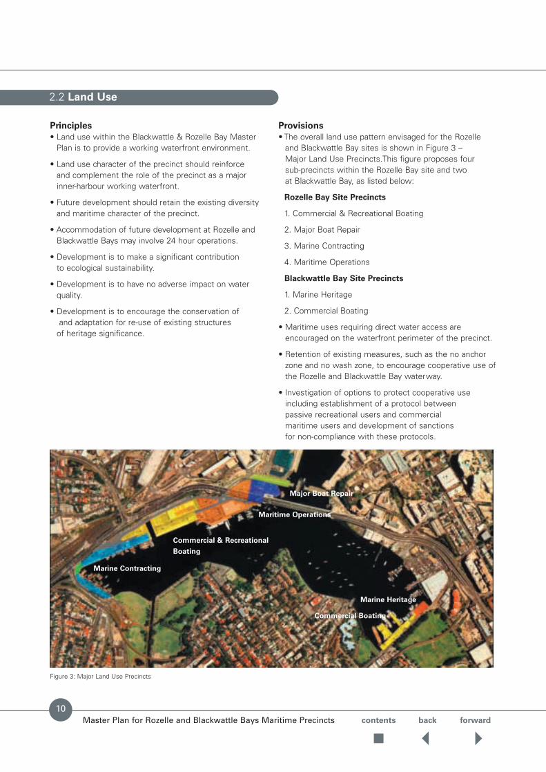
• The overall land use pattern envisaged for the Rozelleand Blackwattle Bay sites is shown in Figure 3 – Major Land Use Precincts.This figure proposes four sub-precincts within the Rozelle Bay site and two at Blackwattle Bay, as listed below:
Rozelle Bay Site Precincts
1. Commercial & Recreational Boating
2. Major Boat Repair
3. Marine Contracting
4. Maritime Operations
Blackwattle Bay Site Precincts
1. Marine Heritage
2. Commercial Boating
• Maritime uses requiring direct water access areencouraged on the waterfront perimeter of the precinct.
• Retention of existing measures, such as the no anchorzone and no wash zone, to encourage cooperative use ofthe Rozelle and Blackwattle Bay waterway.
• Investigation of options to protect cooperative useincluding establishment of a protocol between passive recreational users and commercial maritime users and development of sanctions for non-compliance with these protocols.
Figure 3: Major Land Use Precincts
Major Boat Repair
Maritime Operations
Commercial & Recreational
Boating
Marine Contracting
Marine Heritage
Commercial Boating

Master Plan for Rozelle and Blackwattle Bays Maritime Precincts contents back forward
• A pedestrian and cycle connection is to be includedalong the alignment of the internal access road forRozelle Bay and along Pyrmont Bridge Road inBlackwattle Bay.
• Future development of the existing coal bunker structuremust consider its potential for adaptive re-use whilstacknowledging its heritage significance.
• On a temporary basis, provide for layover berthing ofvessels and other non-commercial uses, which do not prejudice future maritime operations.
• Provide a facility for passive public watercraft at thewestern end of Rozelle Bay on the site identified as R9 in Figures 27 and 28.
• Provide facilities for local food / retail outlets associatedwith the working waterfront operation, as appropriate.
Preferred Land Uses for Major Land Use Precincts
Preferred land uses for each precinct sites are nominatedin Figures 4 – 9. Further detail is provided on preferredland uses and urban design controls for individual sites in Figures 11 – 34.
Preferred Land Uses – Site R1
Preferred Land Uses – Site R2
Preferred Land Uses – Sites R3, R4 and R5
2.2 Land Use cont.
Figure 4: Major Boat Repair Precinct (Site R1)
• Charter vessels
• Heritage fleet
• Dry boat storage
• Marine contractors
• General mixed marine
• Marine repairs
• Heavy marine repairs
• Charter vessels
• Heritage fleet
• Dry boat storage
• Layover berths
• General mixed marine
• Marine contractors
• Heavy marine repairs
• Marine repairs
Figure 6: Commercial & Recreational Boating Precinct (Sites R3, R4, R5)
• Charter vessels
• General mixed marine
• Commercial marineoffices
• Layover berths
• Food & retail outletancillary to the main use
• Waterways operations
Figure 5: Maritime Operations Precinct (Sites R2)
11

2.2 Land Use cont.
Master Plan for Rozelle and Blackwattle Bays Maritime Precincts contents back forward
12
Preferred Land Uses – Sites R6, R7 and R8
• Charter vessels
• Marine contractors
• General mixed marine
• Marine repairs
• Heritage fleet
Preferred Land Uses – Site B1
Preferred Land Uses – Sites B2 and B3
• Charter vessels
• Heritage fleet
• Fishing fleet
• Layover berths
• General mixed marine
Figure 7: Marine Contracting Precinct (Sites R6, R7, R8)
Figure 8: Marine Heritage Precinct (Site B1)
Figure 9: Commercial Boating Precinct (Sites B2, B3)
• General mixed marine
• Maritime-related retail and/or commercial uses
• Non-conforming uses may be considered

Master Plan for Rozelle and Blackwattle Bays Maritime Precincts contents back forward
13
Both the Rozelle Bay site and the Blackwattle Bay site are highly visible from surrounding areas and are ringed by major arterial roads. Rozelle Bay is defined by ridges at Johnston Street, Glebe Point Road and Victoria Roadwith the wide flat valleys of Jubilee Park/Bicentennial Park and the valley traversed by the City West Link Road.
Figure 10 shows the major view corridors and view pointsfrom the water’s edge and adjacent area. The major viewcorridors to the Rozelle Bay site occur at Victoria Road,Glebe Point Road, Johnston Street. See photos and figure.Foreshore viewpoints include the junction of City WestLink with The Crescent, Anzac Bridge and Glebe Point.
Key visual landmarks around Rozelle Bay and BlackwattleBay include:
• Anzac Bridge
• Old Glebe Island Bridge
• White Bay Power Station
• Coal bunkers & gantry crane
• Glebe Island silos
• Sydney University boat shed
• Fig trees (Wentworth Park & Glebe Point)
• Pioneer Concrete plant
The major items to be addressed include maintenance ofimportant view corridors, public domain, foreshore accessand recognition of major focal points and vistas.
Principles
• Provide for a range of opportunities for those workingand visiting the precinct that reflect the maritimetraditions of the working harbour.
• Step down building heights to respect landforms andview sharing.
• Built form must not present a wall of development to thepublic domain.
• Maintain existing views to landmarks to reinforce thediverse visual quality of the area.
• Provide flexibility for the location of maritime buildingsand structures.
• Ensure that development within the sites achieves a high standard of urban design and contributes to a high quality public domain.
• Reinforce major gateways as shown within theLeichhardt Town Plan 2000.
• Ensure the application of the principles of ecologicallysustainable development.
2.3 Views, Built Form and Urban Design
Figure 10: Visual Catchment
View Corridors
Viewpoints
Visually significant
focal points
1
2
6
4
5
3
White BayPower Station
Glebe IslandSilos
SydneyUniversity
PioneerBatching Plant Fig Trees
Coal Bunker
Anzac Bridge

contents back forward
2.3 Views, Built Form and Urban Design cont.
Master Plan for Rozelle and Blackwattle Bays Maritime Precincts
Provisions
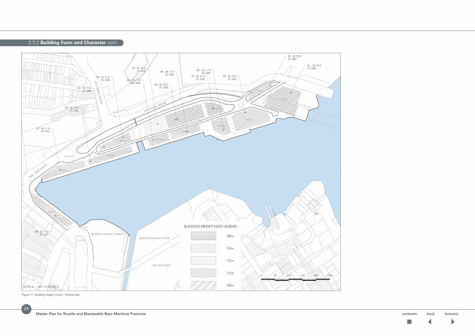
• Building heights across the sites must not exceed theRL heights, measured from A.H.D., shown in the RozelleBay Building Height Limit Plan (Figure 11) and in theBlackwattle Bay Building Height Limit Plan (Figure 32).
• Maximum building roof heights are to be defined as RLsto the topmost part of the roof.
• Site coverage is to be applied to prevent the location ofbuildings, creating a wall of development to the harbouror to the adjacent arterial road network.
• Building must occur within the building envelopes shownin the Master Plan.Rozelle Bay Urban Design ControlPlans (Figures 16, 18, 20, 23, 26) and the Blackwattle Bay Urban Design Control Plan (Figure 31).
• Maximum building envelopes have been set for eachsite. However buildings can only occupy the buildingfootprint and site coverage percentage limits specified in the design requirements for each site (e.g. 20% or 50% site cover) as indicated on Figures 11-34.
• Changes to building envelopes may be considered if it can be demonstrated that it is necessary to theoperational requirements of the proposed use and meets the urban design principles that underpin the building envelopes in the Master Plan.
• As indicated at Figure 11, at Rozelle Bay higher buildingsare to be concentrated at the eastern end of the site and step down towards the water and western endof the site.
• Buildings should not obstruct views to bays alongdesignated view corridors shown on Figure 10.
• Where feasible designated view corridors are not to be obstructed by car parking.
• View corridor from Victoria Road to be retained overbuilding zones to ensure some views are retained toBicentennial Park and water.
• Built form in the Rozelle Bay precinct is not to obstructthe 3 bridges view between the Anzac Bridge towersfrom Bicentennial Park.
• Building design for new development along PyrmontBridge Road is to provide interesting, articulated andproportioned facades to ensure that elevations to theroad do not comprise ‘dead frontage’ but provideopenings where activity can be perceived.
• Future buildings on site B3 at Blackwattle Bay are to beof land mark and innovative design and should achieveviews from Wentworth Park Road to the waters ofBlackwattle Bay.
Panorama 1 – Rozelle Bay from Glebe Point (Note 3 Bridges at right.)
14

contents back forwardMaster Plan for Rozelle and Blackwattle Bays Maritime Precincts
View 1 – Victoria Road to Rozelle Bay View Corridor from Pedestrian Overpass View 2 – Glebe Point Road to Rozelle Bay View Corridor
Panorama 2 – Rozelle Bay from Victoria Road Pedestrian Overpass
• The built form of the buildings should reflect thecharacter of maritime industrial buildings.
• Provide foreshore setbacks to all building zones with a minimum of 10 metres for the majority of the site.(Figures 16, 18, 20, 24, 31, 35)
• Provide building setbacks to all roads and site boundarieszones with a minimum of 3 metres on the narrow sitesand 5 metres for the majority of the site. (Figures 16, 18, 20, 24, 31, 35)
• A view corridor is to be maintained at Wattle Street andwater views are to be enhanced from Wentworth Park.
• Buildings opposite the termination of Wentworth ParkRoad are to be of a landmark and innovative design.
• Building design for new development along PyrmontBridge Road should provide interesting, articulated andproportioned facades where elevations to the road donot comprise ‘dead frontage’ but provide openingswhere activity can be perceived.
• Ensure passive watercraft activities eg, rowing uponBlackwattle Bay and Rozelle Bay are protected.
• Provide for public interaction in and around theBlackwattle Bay Coal Loader.
2.3 Views, Built Form and Urban Design cont.
15

contents back forwardMaster Plan for Rozelle and Blackwattle Bays Maritime Precincts
Panorama 3 – View from Wentworth Park to Blackwattle Bay
View 5 – View from Bayview Crescent to Rozelle Bay View 6 – View from Wattle Street to Blackwattle Bay
View 3 – Johnston Street to Rozelle Bay View Corridor (Note view of Bay
interrupted by light rail overpass.)
View 4 – View from The Crescent to Rozelle Bay
2.3 Views, Built Form and Urban Design cont.
16
contents back forward
General Design Principles
The buildings on these sites are seen in the round fromabove on Anzac Bridge, from land and from the water. The development will be seen from afar as a set ofbuildings, and closer as a series of individual buildings.Views of the sites occur from many public places aroundthe Rozelle and Blackwattle Bays – from the Sydney FishMarkets, Blackwattle Bay Park, Jubilee Park, Glebe Pointand Wentworth Park. Although the buildings should not be replicates, the buildings should be of a consistentscale, form and rhythm. These Guidelines are designed to give consistency without limiting individual expression.
General Principles
AMENITY
• External lighting of buildings can add to the appreciationof the site in terms of uses, architectureand public safety.
• Solar access should be considered to parks and otherimportant public spaces between 11.30am and 2.30pm in winter. Shadow impact assessments are required bydevelopments adjacent to parks to demonstrate impactson solar access in winter and shade in summer.
PUBLIC DOMAIN ELEMENTS
• All public domain furniture elements are to be designedas part of a suite under the guidelines set out in this document.
VEHICLE ACCESS
• Vehicular access across footpaths is to be minimised and designed to limit conflict with pedestrians.
• Where practical, access to car parking and loading areas is to be located away from the main pedestrian thoroughfares.
BUILDING LINE
Refers to the general alignment of the walls of a buildingthat is defined by the building envelope diagrams.
Objective
To achieve developments that sit within the boundaries in order to establish a sensible pattern for development.
Provisions
• New buildings are to provide and/or reinforce the major site axes and connections with surrounding public spaces.
• The entrances of buildings are to be orientated so as to be clear for their primary access.
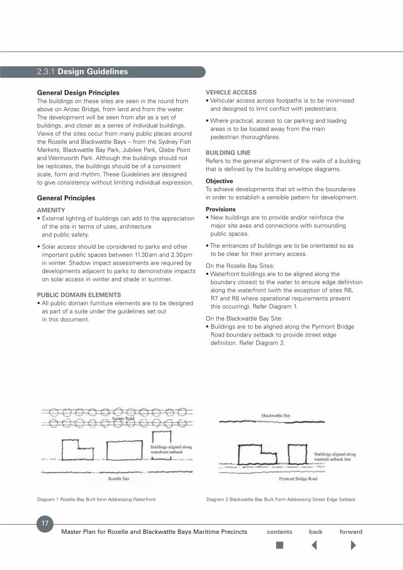
On the Rozelle Bay Sites: • Waterfront buildings are to be aligned along the
boundary closest to the water to ensure edge definitionalong the waterfront (with the exception of sites R6, R7 and R8 where operational requirements prevent this occurring). Refer Diagram 1.
On the Blackwattle Bay Site:• Buildings are to be aligned along the Pyrmont Bridge
Road boundary setback to provide street edge definition. Refer Diagram 2.
Master Plan for Rozelle and Blackwattle Bays Maritime Precincts
2.3.1 Design Guidelines
Diagram 1 Rozelle Bay Built form Addressing Waterfront Diagram 2 Blackwattle Bay Built Form Addressing Street Edge Setback
17

ADDRESS
The address of a building defines a hierarchy betweenpublic, semi-public and private space and is one of the determining factors that establishes character.
Principles
To give order, structure and identity to the site; to clearlyidentify entry points.
Provisions
• Entry points to be clearly demarcated by the articulationof the façade and/or signage and lighting.
• Provide a clear sight line from one end of a block to the other for orientation, surveillance and accessibility.
SAFETY AND SECURITY
Principles
Reinforce the sense of security and provide a safe publicenvironment for operators and users alike.
Provisions
• Provide well lit and defined pathways and entries tobuildings at night.
• Provide lighting to achieve luminescence levelsconsistent with community safety and security to theappropriate Australian Standards.
• Allow casual surveillance of the precinct by inhabitantsof the buildings.
• Promote lively public and semi-public areas throughlocation and number openings or commercial uses on the ground floor.
SITE STRUCTURE
Principles
Reinforce the primary landscape public domain strategy.
Provisions
• Provide a focal point associated with the public accesseasements on the waterfront (refer Diagram 3 andFigure 38) with the use of a taller structure or viewingtower attached to the development. This structure maybe outside the control envelope by a max. 5m height and no more than 20m2 in plan area.This could be usedfor a viewing deck; environmental elements such as solarchimney or tank mounting; mounting for microwavedishes, communications aerials and the like, but is not to be included as useable floor space.
2.3.1 Design Guidelines cont.
Master Plan for Rozelle and Blackwattle Bays Maritime Precincts contents back forward
18
Diagram 3 Built Form Addressing and Marking Public Access Easement

contents back forward
Design of buildings is to be of high standard with materialsand design appropriate for the marine character of the site and responding to the scale and openness of thewater’s edge.
EXISTING BUILDINGS
The existing buildings on the site will remain and form part of the collection of buildings proposed for the site.The building form and character guidelines in this masterplan do not apply to the existing buildings except foraccess and lighting, or as noted in this section.
Conaust Building
The Conaust building is the largest building on the RozelleBay site. Its mass defines, in part, the scale of futuredevelopment to the west of the site. The large simple form is to remain. If re-painted it should use colours fromthe palette proposed in these guidelines. The open framestructure to the south is to remain exposed as much aspossible. Any infill should accept the form of the existingbuilding, although it may change the detailing to reveal the structure.
CHARACTER
The character of a building is the result of siting, use,height, depth, articulation, colours, textures and finishes.Existing marine typologies around Sydney Harbour providemany clues and principles.
Principles
To achieve a development that reflects its uses andresponds to its particular context and that follows design guidelines set in this document.
Provisions
• Use framed structural systems. Refer Photo 1.
• Express framing systems as a composite and hierarchy of primary, secondary and tertiary elements. Refer Photo 1.
• Membrane structures are not permitted, except for temporary uses of no more than 6 months period.Structures are to be located within the allowable buildingarea. Refer Photo 2.
• Avoid heavy and clumsy forms. Refer Photo 3.
• Containers are not be used for office accommodation or be located in permanent storage areas.
Master Plan for Rozelle and Blackwattle Bays Maritime Precincts
2.3.2 Building Form and Character
Photo 1 Desirable Building Form Expressing Framing System Photo 3 Awkwardly Proportioned Structure and Form
Photo 2 Large Scale Permanent Membrane Structures for Temporary
Use Only
19

2.3.2 Building Form and Character cont.
Master Plan for Rozelle and Blackwattle Bays Maritime Precincts contents back forward
20
Photo 6 Undesirable Blank FacadePhoto 5
BUILDING HEIGHT
Principles
To achieve a development that responds to the topography,infrastructure and existing buildings on the site and respects the harbour frontage.
Provisions
• Developments are not to exceed the height nominatedby the development envelope.
• Generally, the height is to be lower closer to the water’s edge.
• The height of the building should be reduced visually by changing colour or materials horizontally.
ARTICULATION
Building articulation can be generated through theexpression of separate parts of a development: openings,structure, access stairs, walkways, balconies etc, andthrough design solutions to environmental conditions of orientation, noise, breezes and views, etc.
Principles
To achieve a development with buildings of a distinctivecontemporary character articulated in response to the local and environmental context and expressing marine environment.
Provisions
• Articulation of the building must be integrated with thebuilding design and its massing.
• Articulation is to occur behind the line of development.
STRUCTURE
• The structure should be a primary ordering system on the building facade and expressed as such. Refer Photos 4 & 5.
• Structure should be highlighted in a colour distinct from the rest of the building. Refer Photos 4 & 5.
FACADE
• Building openings are to be clearly articulated throughthe use of deep recesses, or expressed within thestructural hierarchy.
• The facade should have an expressed secondary andtertiary ordering system (after the principal structuralsystem) that modulates the scale of the building. Avoidbland, unarticulated and blank facades. Refer Photo 6.
Photos 4 & 5 Articulated Building Facade with Expressed Ordering System
Reinforced with Colour Highlights

contents back forwardMaster Plan for Rozelle and Blackwattle Bays Maritime Precincts
2.3.2 Building Form and Character cont.
Photo 8
Photo 9
Photo 7 Photo 10
Photo 11
Photo 12 Undesirable Heavy Roof Form
21
2.3.2 Building Form and Character cont.
Master Plan for Rozelle and Blackwattle Bays Maritime Precincts contents back forward
22
the built form and articulate the lively character of theprecinct and its proposed uses.
Provisions
• Achieve developments that use finishes that have a long life.
• Building materials selected should display a combinationof the following Ecologically Sustainable Developmentqualities; a low embodied energy, durability, recycled orable to be recycled, non-polluting in manufacture, useand disposal, contribute to a healthy indoor air quality,through minimised toxic fume emission and out-gassingfrom paints, carpets, glues and pest control practices.
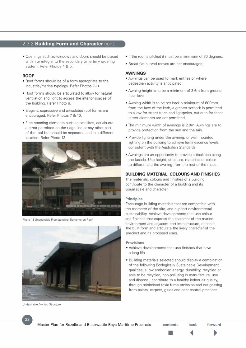
Undesirable Awning Structure
• Openings such as windows and doors should be placedwithin or integral to the secondary or tertiary orderingsystem. Refer Photos 4 & 5.
ROOF
• Roof forms should be of a form appropriate to theindustrial/marine typology. Refer Photos 7-11.
• Roof forms should be articulated to allow for naturalventilation and light to access the interior spaces of the building. Refer Photo 8.
• Elegant, expressive and articulated roof forms areencouraged. Refer Photos 7 & 10.
• Free standing elements such as satellites, aerials etc are not permitted on the ridge line or any other part of the roof but should be separated and in a differentlocation. Refer Photo 13.
• If the roof is pitched it must be a minimum of 30 degrees.
• Broad flat curved rooves are not encouraged.
AWNINGS
• Awnings can be used to mark entries or wherepedestrian activity is anticipated.
• Awning height is to be a minimum of 3.6m from groundfloor level.
• Awning width is to be set back a minimum of 600mmfrom the face of the kerb, a greater setback is permittedto allow for street trees and lightpoles, cut outs for thesestreet elements are not permitted.
• The minimum width of awnings is 2.0m. Awnings are toprovide protection from the sun and the rain.
• Provide lighting under the awning, or wall mountedlighting on the building to achieve luminescence levelsconsistent with the Australian Standards.
• Awnings are an opportunity to provide articulation alongthe facade. Use height, structure, materials or colour to differentiate the awning from the rest of the mass.
BUILDING MATERIAL, COLOURS AND FINISHES
The materials, colours and finishes of a building contribute to the character of a building and its visual scale and character.
Principles
Encourage building materials that are compatible with the character of the site, and support environmentalsustainability. Achieve developments that use colour and finishes that express the character of the marineenvironment and adjacent port infrastructure, enhance
Photo 13 Undesirable Free-standing Elements on Roof

Master Plan for Rozelle and Blackwattle Bays Maritime Precincts contents back forward
• Use of building materials and interior design thatminimises the need for chemical pest control and maximises opportunities for integrated pest management.
• The principles and properties of thermal mass, glazingand insulation are to be incorporated into the design of new buildings to reduce the need to artificially heat or cool these buildings. Refer to the relevantAustralian Standards.
• Use appropriate combinations of bulk and reflectiveinsulation in walls, ceilings and roofs to improve thermal performance.
• Use of timber should not result in the destruction of old growth forests, native or foreign rainforest.The use of recycled timber is encouraged.
• Visible light reflectivity from building materials used onthe facades of new buildings should not exceed 20%.
• Use materials and colours that break down thebuilding mass.
• Restrict the palette of materials to reinforce the maritimevernacular such as timber, steel, lightweight cladding.
• Reinforce the structure of the buildings by expressing it on the facade of the building, and painting it a distinctcolour, where appropriate.
• The colours used should make the mass of largebuildings recede though distinct colours can be used to highlight structure and articulated elements.
• Where colour applied, use a restricted palette of colours:– Overall dominating colours are to be a muted palette of
blue greys, warm greys and varieties within.– Highlight colours should be chromatically more intense colours such as red, yellow, blues, purple; or
contrasting colours to the overall colour palette.
ACCESS
It is important that people of all types and degrees ofdisability are able to access all parts of the building.
Building configuration, access and internal circulation have a fundamental impact on the orientation and quality of the internal environment.
Principle
To achieve a development with an appropriate and efficientcirculation system that facilitates buildings with good orientation and that all people can use and enjoy the full range of facilities offered.
Guidelines
• All new developments are required to prepare an ‘AccessStrategy’ to the satisfaction of the consent authoritywhich shall satisfy AS 1492.2 / AS1428 as a minimum.
• Ensure that barrier free access is provided to commonareas of all common areas of all buildings.
LIGHTING
Objective
Ensure the creation of a safe and functional workingenvironment. Highlight dynamic features and elements of the working harbour structures through lighting.
Provisions
• Safety is the primary concern for the lighting strategy.
• Reinforce the rhythm of the structural system of thebuildings through lighting.
• Lighting should highlight:– signage– entrances
2.3.2 Building Form and Character cont.
– working areas.
• Lighting should highlight articulated elements such ascranes, towers, gantries etc.
• Create a lighting strategy for each lease integrated withthe overall site wide lighting strategy by a qualifiedLighting Engineer.
• Lighting should not create a glare source when viewedfrom the water.
Example of Dominant Colours Example of Highlight Colours
23
2.3.2 Building Form and Character cont.
Master Plan for Rozelle and Blackwattle Bays Maritime Precincts
Figure 11: Building Height Limits – Rozelle Bay
contents back forward
24
2.3.2 Building Form and Character cont.
Master Plan for Rozelle and Blackwattle Bays Maritime Precincts
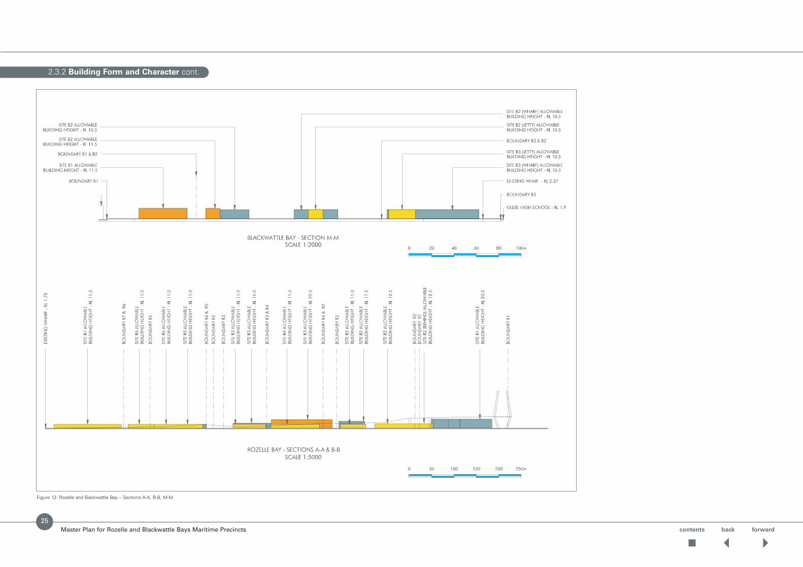
Figure 12: Rozelle and Blackwattle Bay – Sections A-A, B-B, M-M
contents back forward
25
2.3.2 Building Form and Character cont.
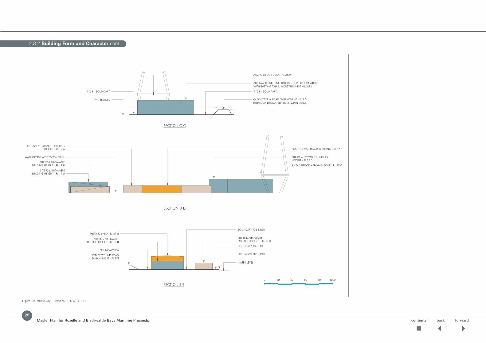
Master Plan for Rozelle and Blackwattle Bays Maritime Precincts
Figure 13: Rozelle Bay – Sections F-F, G-G, H-H, I-I
contents back forward
26

2.3.2 Building Form and Character cont.
Master Plan for Rozelle and Blackwattle Bays Maritime Precincts
Figure 14: Rozelle Bay – Sections F-F, G-G, H-H, I-I
contents back forward
27

contents back forward
2.3.2 Building Form and Character cont.
Master Plan for Rozelle and Blackwattle Bays Maritime Precincts
Rozelle Bay Site R1
Data
• Site Area 15,900 sq. m
• Water Frontage 90 lin. m
• Water Depth 5 – 10m
Building Envelope
• Allowable new building height RL 23.0 and 50% site coverage
• Generated parking, truck access and loading to beaccommodated on site
• Site suitable for highest land and water activity
Preferred Land Uses
• Charter vessels
• Dry boat storage
• General mixed marine
• Heavy marine repairs
• Heritage fleet
• Marine contractors
• Marine repairs
Figure 15: Rozelle Bay Site R1
28
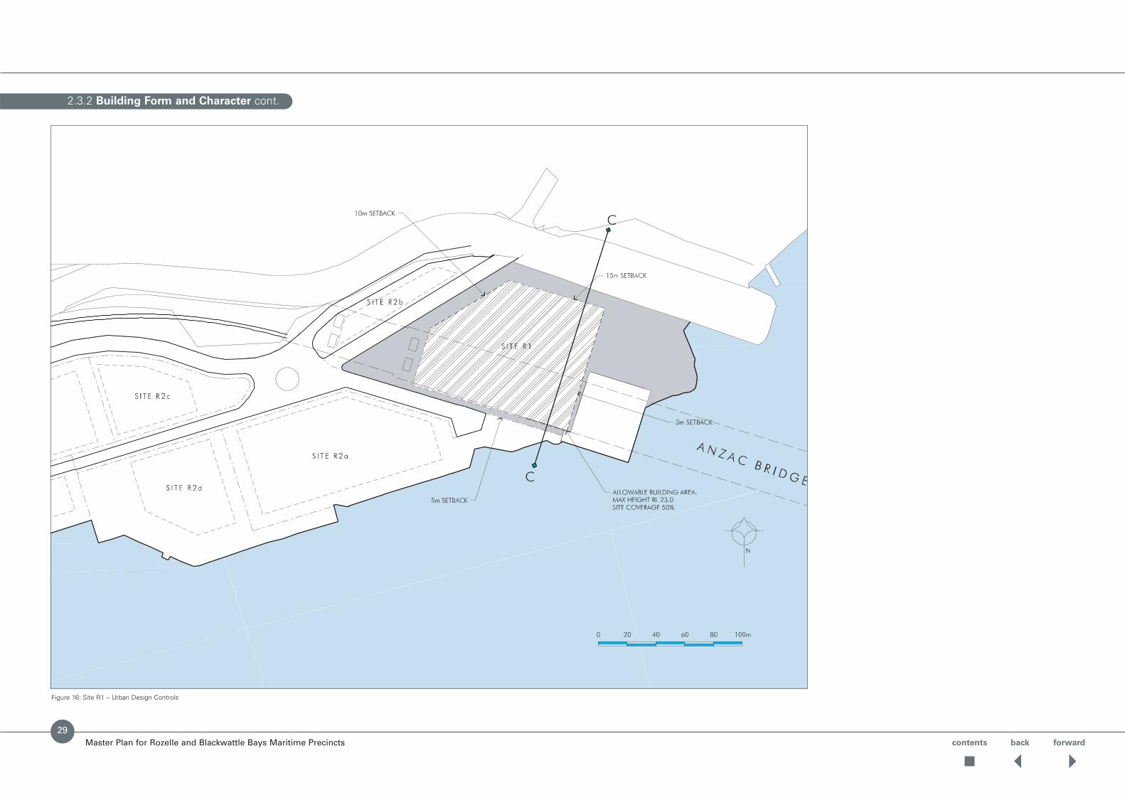
2.3.2 Building Form and Character cont.
Master Plan for Rozelle and Blackwattle Bays Maritime Precincts
Figure 16: Site R1 – Urban Design Controls
contents back forward
29

contents back forward
2.3.2 Building Form and Character cont.
Master Plan for Rozelle and Blackwattle Bays Maritime Precincts
Rozelle Bay Site R2
Data
• Site Area 26,700 sq. m
• Water Frontage 380 lin. m
• Water Depth 5 – 10m
Urban Design Requirements
• Allowable new building height of RL 11.0, RL 12.5, RL 17.5 and RL 23.0 and 50% site coverage
• Generated parking, truck access and loading to beaccommodated on site
• Site suitable for high land and water activity
• Pedestrian working waterfront access required along foreshore
Preferred Land Uses
• Charter vessels
• Commercial marine offices
• General mixed marine
• Layover berths
• Waterways operations
• Food & retail outlet ancillary to main use
Figure 17: Rozelle Bay Site R2
30

2.3.2 Building Form and Character cont.
Master Plan for Rozelle and Blackwattle Bays Maritime Precincts
Figure 18: Site R2 – Urban Design Controls
contents back forward
31

contents back forward
2.3.2 Building Form and Character cont.
Master Plan for Rozelle and Blackwattle Bays Maritime Precincts
Rozelle Bay Site R3
Data
• Site Area 19,420 sq. m
• Water Frontage 100 lin. m
• Water Depth 5 – 10m
Urban Design Requirements
• Allowable new building height of RL 22.0, RL 14.0 and RL 11.0 and 50% site coverage
• Generated parking, truck access and loading to beaccommodated on site with additional on street parking available adjacent
• Active land usage acceptable, limited water usage
• Existing canal to be opened
• A land connection between sites R3 and R5 is requiredto allow the potential for joint use of travel lifts on eitherside of channel
Preferred Land Uses
• Dry boat storage
• General mixed marine
• Heavy marine repairs
• Heritage fleet
• Marine repairs
Figure 19: Rozelle Bay Site R3
32
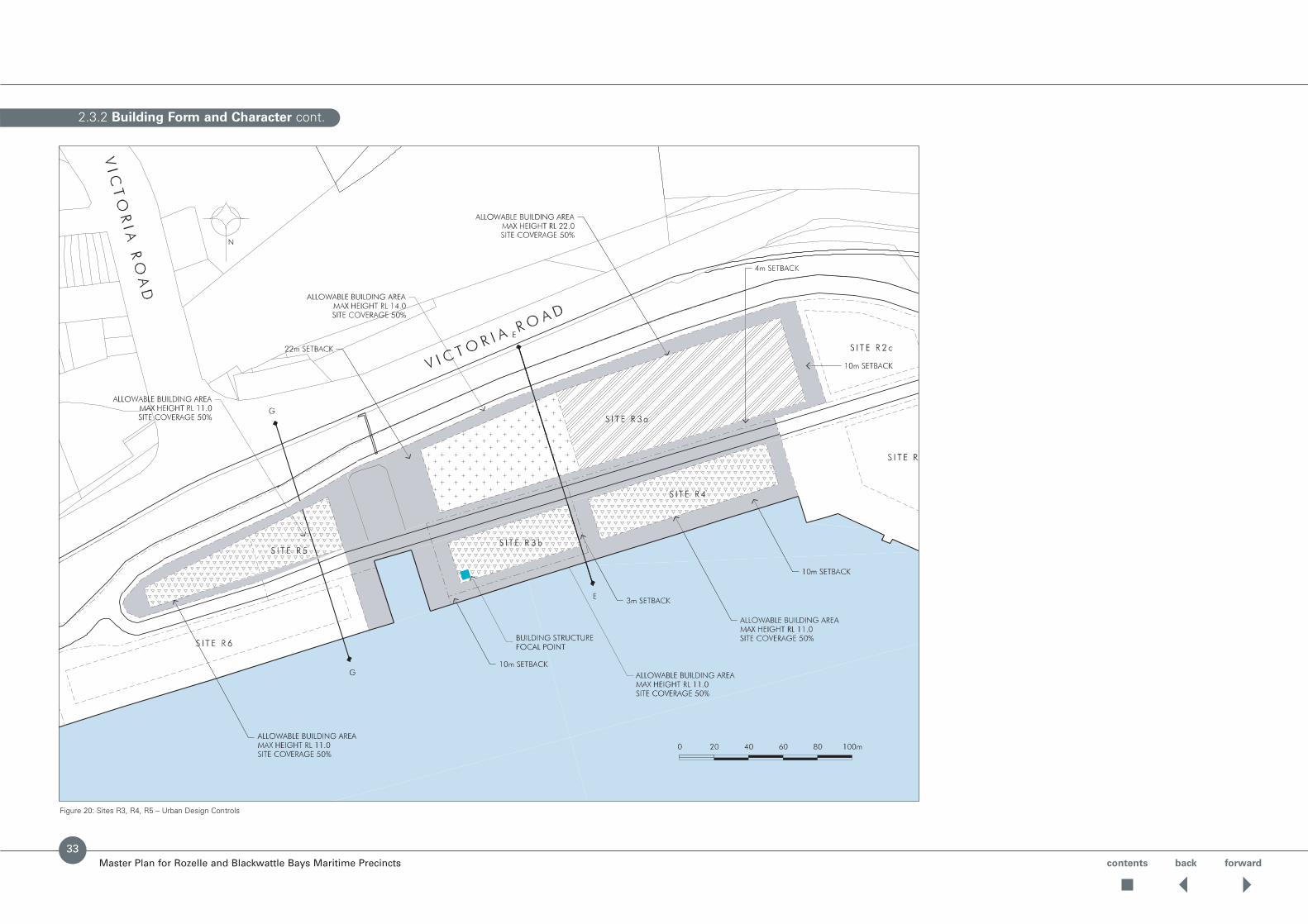
2.3.2 Building Form and Character cont.
Master Plan for Rozelle and Blackwattle Bays Maritime Precincts
Figure 20: Sites R3, R4, R5 – Urban Design Controls
contents back forward
33

2.3.2 Building Form and Character cont.
Master Plan for Rozelle and Blackwattle Bays Maritime Precincts contents back forward
34
Rozelle Bay Site R4
Data
• Site Area 6,320 sq. m
• Water Frontage 210 lin. m
• Water Depth 5 – 10m
Urban Design Requirements
• Allowable new building height of RL 11.0 and 50% site coverage
• Generated parking, truck access and loading to beaccommodated on site
• Active land and water usage acceptable
• Pedestrian working waterfront access proposed
Preferred Land Uses
• Charter vessels
• Dry boat storage
• General mixed marine
• Heavy marine repairers
• Heritage fleet
• Layover berths
• Marine repairs
Rozelle Bay Site R5
Data
• Site Area 5,800 sq. m
• Water Frontage 100 lin. m
Urban Design Requirements
• Allowable new building height of RL 11.0 m and 50% site coverage
• Generated parking, truck access and loading to beaccommodated on site
• Active land usage acceptable, limited water usage
• Pedestrian working waterfront access require adjacent to canal
• A land connection between sites R3 and R5 is requiredto allow the potential for joint use of travel lifts on eitherside of channel
Preferred Land Use
• Dry boat storage
• General mixed marine
• Heavy marine repairs
• Heritage fleet
• Marine contractors
• Marine repairs
Figure 21: Rozelle Bay Site R4 Figure 22: Rozelle Bay Site R5

Master Plan for Rozelle and Blackwattle Bays Maritime Precincts contents back forward
Rozelle Bay Site R6
Data
• Site Area 6,540 sq. m
• Water Frontage 180 lin. m
• Water Depth 5 – 10m
Urban Design Requirements
• Allowable new building height of RL 11.0 and 20%site coverage
• Generated parking, truck access and loading to beaccommodated on site
• Low site coverage facilitates truck access
• Active land and water usage acceptable
Preferred Land Uses
• Charter vessels
• General mixed marine
• Heritage fleet
• Marine contractors
• Marine repairs
2.3.2 Building Form and Character cont.
Figure 23: Rozelle Bay Site R6
35
2.3.2 Building Form and Character cont.
Master Plan for Rozelle and Blackwattle Bays Maritime Precincts contents back forward
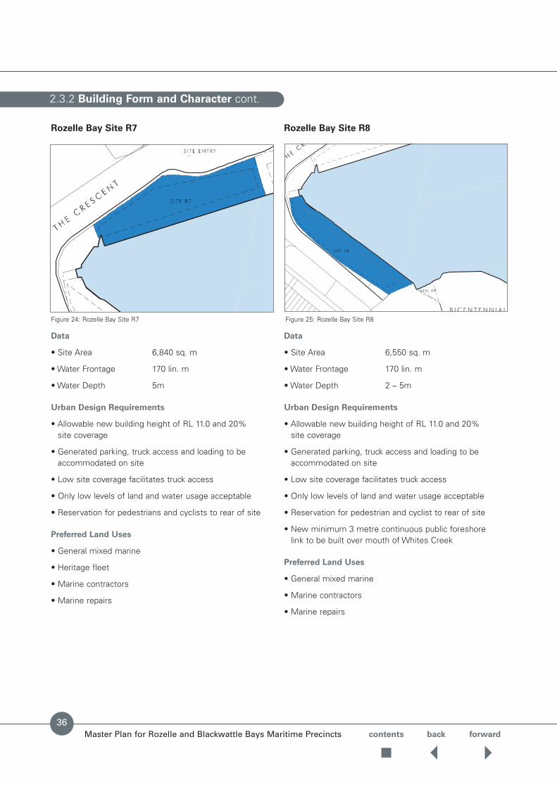
36
Rozelle Bay Site R7
Data
• Site Area 6,840 sq. m
• Water Frontage 170 lin. m
• Water Depth 5m
Urban Design Requirements
• Allowable new building height of RL 11.0 and 20% site coverage
• Generated parking, truck access and loading to beaccommodated on site
• Low site coverage facilitates truck access
• Only low levels of land and water usage acceptable
• Reservation for pedestrians and cyclists to rear of site
Preferred Land Uses
• General mixed marine
• Heritage fleet
• Marine contractors
• Marine repairs
Rozelle Bay Site R8
Data
• Site Area 6,550 sq. m
• Water Frontage 170 lin. m
• Water Depth 2 – 5m
Urban Design Requirements
• Allowable new building height of RL 11.0 and 20% site coverage
• Generated parking, truck access and loading to beaccommodated on site
• Low site coverage facilitates truck access
• Only low levels of land and water usage acceptable
• Reservation for pedestrian and cyclist to rear of site
• New minimum 3 metre continuous public foreshore link to be built over mouth of Whites Creek
Preferred Land Uses
• General mixed marine
• Marine contractors
• Marine repairs
Figure 24: Rozelle Bay Site R7 Figure 25: Rozelle Bay Site R8

2.3.2 Building Form and Character cont.
Master Plan for Rozelle and Blackwattle Bays Maritime Precincts
Figure 26: Sites R6, R7, R8 – Urban Design Controls
contents back forward
37

2.3.2 Building Form and Character cont.
Master Plan for Rozelle and Blackwattle Bays Maritime Precincts contents back forward
Rozelle Bay Site R9
Data
• Site Area: 380 sq. m
• Water Frontage:25 lin. m
• Water Depth: 2m
Urban Design Requirements
• No parking permitted
• Only low levels of land and water usage acceptable
• 24 hour pedestrian access
Preferred Land Uses
• Open space
• Public passive boating
Public Recreation Facility
As indicated earlier, one of the objectives of the City West REP is to safeguard the continued use of Rozelle andBlackwattle Bays for non-motorised water-basedrecreational activities such as rowing and canoeing.
In recognition of this objective it is intended to provide a facility for passive public watercraft at the western endof Rozelle Bay on the site identified as R9 in Figure 27.
This site is considered to be the most advantageous for a range of reasons including:
• Linkage to Bicentennial Park recreational area
• Lower water depths suited to small craft launching
• Space for boat storage and launching facilities
• Close proximity to nearby Leichhardt Council residential areas
• Separation from commercial waterfront activity along thenorthern shore of Rozelle Bay.
Figure 27: Rozelle Bay Site R9
Figure 28: Public Boating Facilities Opportunity
CityWestLink
The Crescent
MMIIC Land
SRA Land
RTA Land
Opportunity forpublic passivewatercraft facility
Passive Recreation
Rozelle BayLight RailStation
Bi Centennial Park
38

contents back forwardMaster Plan for Rozelle and Blackwattle Bays Maritime Precincts
Rozelle Bay Site R10
Data
• Site Area 3,220 sq. m
• Water Frontage Nil
Urban Design Requirements
• Allowable new building height 8m and 50% site coverage
• Generated parking, truck access and loading to be accommodated on site
• Only low levels of land usage acceptable
Preferred Land Uses
• General mixed marine use
• Open space
Blackwattle Bay Site B1
Data
• Site Area 2,500 sq. m
• Water Frontage Nil
• Water Depth 5m
Preferred Land Uses
• General mixed marine use
• Maritime-related retail and/or commercial uses
• Non-conforming uses may be considered
Urban Design Requirements
• Allowable new building height of RL 11.5 and 50% site coverage
• Existing coal bunker & associated site office to beadaptively re-used as per Heritage Guidelines andConservation Management Plan guidelines (refer to section 2.7)
• Parking, truck access and loading to be accommodatedon site
• Active land and water usage acceptable
• Waterfront pedestrian access required
• Establishment of pedestrian access between site B1 and the Sydney Fish Markets.
2.3.2 Building Form and Character cont.
Figure 30: Marine Heritage Precinct Site B1Figure 29: Rozelle Bay Site R10
39

2.3.2 Building Form and Character cont.
Master Plan for Rozelle and Blackwattle Bays Maritime Precincts
Figure 31: Sites B1, B2, B3 – Urban Design Controls
contents back forward
40

2.3.2 Building Form and Character cont.
Master Plan for Rozelle and Blackwattle Bays Maritime Precincts
Figure 32: Blackwattle Bay – Sections J-J, K-K, L-L
contents back forward
41
2.3.2 Building Form and Character cont.
Master Plan for Rozelle and Blackwattle Bays Maritime Precincts contents back forward
Blackwattle Bay Site B2
Data
• Site Area: 5,570 sq. m
• Water Frontage:340 lin. m (includes 160m on jetty and 70m on B1 wharf)
• Water Depth: 5 -10m
Urban Design Requirements
• Allowable new building height on wharfs of RL 10.5 and50% site coverage
• Allowable new building height on jetty to be of RL 10.5within allowable footprint
• Generated parking, truck access and loading to beaccommodated on site
• Active land and water usage acceptable
• Pedestrian working waterfront access required
Preferred Land Uses
• Charter vessels
• Fishing fleet
• General mixed marine
• Heritage fleet
• Layover berths
Blackwattle Bay Site B3
Data
• Site Area: 5,800 sq. m
• Water Frontage:300 lin. m (includes jetty perimeter of 190m)
• Water Depth: 5m
Urban Design Requirements
• Existing structures to be demolished
• Allowable new building height on wharfs of RL 10.5 and50% site coverage
• Allowable new building height on jetty to be of RL 10.5within allowable footprint
• Generated parking, truck access and loading to beaccommodated on site
• Unrestricted hours of operation
• Active land and water usage acceptable
• Pedestrian working harbour access required
• Public footpath connection to Glebe High School
Preferred Land Uses
• Charter vessels
• Fishing fleet
• General mixed marine
• Heritage fleet
• Layover berths
Figure 33: Blackwattle Bay Site B2 Figure 34: Blackwattle Bay Site B3
42

Master Plan for Rozelle and Blackwattle Bays Maritime Precincts contents back forward
The developments and activities should be in accordancewith ecologically sustainable development (ESD) principlesfor meeting the needs of the present without compromisingthe ability of future generations to meet their own needs.
Principles
• Ensure that new development and activities take place in accordance with ESD principles.
• Minimise the impact of maritime operations on themarine environment.
• Minimise impacts of maritime operations on the urbanenvironments whilst recognising the operationalrequirements of the waterfront use precincts. (ie noise, water quality).
Requirements for remediation of contaminated land are tobe in accordance with the provisions of the City West REP.
KEY PRINCIPLES
The four key Principles for the design of sustainabledevelopments and buildings are:
1. To minimise external environmental impacts during theirconstruction, operation and disposal.
2. To minimise resource consumption during theirconstruction, operation and disposal.
3. To provide comfortable and healthy indoor environments.
4. To optimise their functionality and utilisation.
Each of these key principles covers a range of ESD issues.
ENVIRONMENTAL MANAGEMENT PLAN
• An Environmental Management Plan (EMP) is required to be prepared and accompany a developmentapplication for each of the Rozelle and Blackwattle Bay sites. The EMP is to address ESD principles,stormwater management, water quality, noisemanagement, retention and recycling of buildings,contamination, management during demolition, removal and construction phases, waste management and waste minimisation.
ENVIRONMENTAL NOISE
• The development needs to take into account theguidelines of the Environment Protection Authority (EPA) Industrial Noise Policy. A noise management plan may need to be prepared with a developmentapplication that includes:• Background noise monitoring.• Predicted noise levels from the proposed activities.• Assessment against the noise guidelines, and
proposals to mitigate and manage the noise if it exceeds the noise limits.
• Monitoring after the commencement of operations.
• The noise guidelines set upper limits, or an overall cap,on noise from different land uses that impacts on thesurrounding areas. These criteria are to be applied byconsent authorities when considering developmentapplications. They will provide for an equitable means of determining noise levels when a number of new industries with noise impacts are planned for a particular locality.
STORMWATER MANAGEMENT
• Consideration needs to be given to measures to reducethe impact of stormwater on waterways in conjunctionwith local councils and other agencies. This wouldpotentially include the installation of gross pollutanttraps, provision of a water detention basin and othermeasures to intercept stormwater so that it can bedischarged in a controlled way.
• Drainage surface runoff and roof drainage should becollected and, where possible, drained to existing outlets in the seawall. Inlet pits should include sediment collection sumps/traps to minimise the sediment discharged to the bays in runoff.
• The development will need to refer to the Port JacksonSouth Catchment Management Plan and LeichhardtCouncil’s stormwater management plans.
• Where possible, manage stormwater flows generated on site as an integral part of the public domain landscapeto minimise the volume and enhance quality of runoffentering the harbour.
2.4 Ecologically Sustainable Development Principles
43
contents back forwardMaster Plan for Rozelle and Blackwattle Bays Maritime Precincts
MARINAS AND BOAT REPAIR FACILITIES
• Development applications should also address theEnvironment Protection Authority’s EnvironmentalGuidelines for Best Management Practice for Marinas & Boat Repair Facilities (1999) with particular reference to liquid wastes, solid wastes, spray operations, TBTpaint avoidance, solvents and cleaning agent odours,stormwater, excessive noise, sewage, grey water and bilge water requirements.
• Consideration should be given to a first flush system of pollution segregation for future boat repair facilities.
• Developments should consider Sydney Water’sguidelines on total water cycle management.
SEDIMENT AND EROSION
• Development applications will need to consider thepreparation of a Sediment and Erosion Control Plan in accordance with Managing Stormwater, Soils and Construction Manual 1998, (NSW Department of Housing).
• Soil testing will be required if excavation greater that 650 millimetres below ground level is proposed on landidentified as Class 1-4 on acid sulfate maps located atLeichhardt Council and DUAP.
• The City West REP requires that the consenting authoritymust not consent to development on a site or part of a site unless consideration as to whether there is any risk to public health or safety from contamination is established. Further, appropriateremediation measures will have to be undertaken toremove such a risk.
LANDSCAPE
• Minimise the use of chemicals (pesticides, herbicides,and fertilisers) by designing for diversity, careful species selection, and by using appropriate plantingdetails and specifications.
• Use endemic plant species where possible to enhancelocal biodiversity.
• Select plant material that requires least amount ofirrigation. Ensure that organic mulching is used toincrease in-ground water retention.
• Assess the source of any imported soil and othermaterial for contamination and weeds.Imported material should be tested by an approved certifier to test for contaminents.
• Control and clean stormwater run-off from potentialpolluting sources such as car parks and storage areas.
• Incorporate stormwater ‘filters’, water control ponds,detention basins and gross pollutant traps into thelandscape structure where appropriate. Generallymaximise the amount of ‘soft’ landscape areas to increase stormwater infiltration.
• Ensure tree planting is included in car parks and storageareas to reduce heat load of hard stand surfaces.
• Recycle green and organic waste during establishmentand maintenance of the landscape.
2.4 Ecologically Sustainable Development Principles cont.
44

Master Plan for Rozelle and Blackwattle Bays Maritime Precincts contents back forward
2.4 Ecologically Sustainable Development Principles cont.
Sustainable Building Design Principles
Scope
Sustainable building practices require the application of a range of sustainable design principles describedbelow.While the principles can be grouped under thefollowing headings for convenience, they are allinterrelated and should not be considered in isolation.
In most cases, it requires a combination of these designprinciples to address each sustainable building objective. In order to minimise greenhouse gas emissions it may be necessary to address most of the above principles.
BUILDING ORIENTATION, SHAPE, FORM
AND PLANNING
• Comply with the NSW Government “Code of Practice for the Construction Industry” for ecologicallysustainable development.
• Appropriate building orientation, shape, form andplanning are required to optimise passive design foreffective solar control, daylight access, ventilation andminimised physical impacts on the surrounding areas.
• While building orientation for optimum passive design is desirable, orientation with street patterns and urbanplanning requirements should be respected.
• Orientations with north or south-facing major elevations are easiest for designing solar control and daylight access.
• Ensure the building does not restrict solar access to neighbouring buildings and open spaces.
• The building orientation, shape and form should bedesigned to take advantage of cool summer winds,control cold winter winds and avoid creating adversewind effects around the building.
• Narrow floor plates with windows along opposite walls would ensure good daylight access and natural ventilation.
• For single-sided ventilation (openings along one side), the maximum floor depth (distance from openings) for effective ventilation is generally 2 to 2.5 times the ceiling height.
• For cross-ventilation (openings along opposite sides), the maximum floor width (distance between oppositeopenings) for effective ventilation is generally 5 times the ceiling height.
• As well as meeting functional requirements, occupiedareas should be planned to take advantage of daylightand controlled solar access.Areas with lower daylightlevels could be used for intermittent occupancy or lower quality accommodation.
• Use service cores (eg stores, toilets, stairs) andcirculation areas as buffer zones between occupied areasand areas with high heat loads (eg east and west elevations) if necessary.
BUILDING ENVELOPE AND STRUCTURE
• The building envelope and structure should be designedto passively modify the ambient conditions to provide acomfortable and healthy indoor environment.The designshould aim to minimise heat gain and loss, optimisesolar control (minimise undesirable summer solar loadand maximise useable winter solar access), optimisedaylight access, moderate indoor conditions, optimiseventilation and minimise infiltration, and control noisetransmission into and from the building.
• Locate and size windows and openings, balancing the needs of providing visual access to the exterior,controlling solar heat load and daylight access, andproviding effective ventilation.
• Select building envelope elements (eg roof, wall,windows) with high thermal resistance (R-value) tominimise heat gain and loss through the envelope,considering issues such as insulation, single or double-glazing, window-to-wall ratios.
• Select transparent or translucent building envelopeelements (eg windows, skylights) with low solar heatgain factors (SHGF) or low shading coefficients (SC) and high visible light transmittance, to minimise solarheat gain and maximise daylighting.
• Where appropriate use the building structure for thermalmass to moderate peak heat loads, in conjunction with a strategy to dissipate the stored heat (eg nightventilative cooling, ground-coupling as in slab-on-ground constructions).
• Design the building envelope, particularly the openings,to limit noise transmission into or from the building.
45

contents back forwardMaster Plan for Rozelle and Blackwattle Bays Maritime Precincts
MATERIAL SELECTION
• The selection of appropriate materials is required to minimise external environmental impacts andconsumption of non-renewable resources, to ensurehealthy indoor environments, and to optimise thefunctionality and life of the building. Consider the full life cycle of materials.
• Select building materials and building elements that are manufactured with low resource consumption (eg energy, water, raw materials), low environmentalimpacts and high recycled content.
• Any timber used should be recycled timber, or timberfrom plantations or sustainable regrowth forests.
• Select materials that are durable, require lowmaintenance and have low environmental impacts (eggreenhouse gas emissions, ozone depletion) during theirservice life.
• Avoid the use of ozone-depleting substances such aschlorofluorocarbons (CFCs) and hydrochlorofluorocarbons(HCFCs).Where such substances are still in use inexisting installations, provide a management strategythat includes containment, leak minimisation andeventual replacement.
• Reduce quantities of materials by modifying orrefurbishing instead of demolishing wherever possible.
• Select materials that can be reused or recycled at theend of life.
• Select interior materials and finishes with low emissionsof gases (eg volatile organic compounds), toxic fumes,hazardous substances, dust and fibres, to ensure goodindoor air quality.
SOLAR CONTROL AND DAYLIGHTING
• Minimise direct solar radiation (heat gain) into thebuilding in summer.
• Optimise the quality and quantity of daylight in theperimeter zones of the building.
• For deeper planned buildings, daylight access and naturalventilation can be provided through skylights, atria, lightwells and courtyards without excessive solar load andthermal discomfort.
• East-facing and west-facing glazing is more likely to besource of high solar heat loads and glare, being moredifficult to shade and design for effective daylighting.
The extent of east-facing and west-facing glazing shouldbe minimised unless effective shading or appropriateglazing types are provided.
• External shading is preferred, as it is more effective than internal shading for controlling direct solar radiation (heat gain).
• Internal shading can be used to control glare but shouldnot be the primary means of controlling solar heat gain.
• Select solar control glazing with low solar heat gainfactors (SHGF) or low shading coefficients (SC) and
high visible light transmittance.
VENTILATION
• Effective ventilation is required to remove indoorpollutants (eg fumes, odours, moisture, heat) andprovide comfortable and healthy indoor environments.
• Maximise the use of natural ventilation before resortingto mechanical ventilation.
• Ensure mechanical ventilation systems are energy efficient.
2.4 Ecologically Sustainable Development Principles cont.
46

Master Plan for Rozelle and Blackwattle Bays Maritime Precincts contents back forward
COOLING
• Effective passive cooling in summer contributes tominimising energy consumption.
• Optimise the effectiveness of passive cooling byminimising heat gains, moderating the heat loads by using thermal mass and using ventilative cooling to dissipate the stored heat.
• Maximise the use of passive cooling before resorting to mechanical cooling and air conditioning.
• Ensure mechanical cooling and air conditioning systemsare energy efficient.
HEATING
• Design for controlled solar access in winter (with due regard to glare) and the use of thermal mass to store heat.
• Maximise the use of passive heating before resorting to active heating systems.
• Select the type of active heating system mostappropriate for the situation.For instance, space heating(ie heating the space with convection heaters, ductedheating systems, heat pumps or similar) is moreappropriate for areas with normal ceiling heights, andradiant heating (ie only heating the occupants) is moreappropriate areas with higher ceilings, larger volumesor high ventilation rates.
• Ensure active heating systems are energy efficient.
ENERGY EFFICIENCY
• Minimise energy demand by adopting passive designsolutions first (eg exploiting local climate and intrinsicproperties of the design and materials), before resortingto hybrid or active design solutions (eg energy-consuming engineering services or systems). Where active systems are necessary optimiseengineering services design.
• All new buildings should achieve a SEDA Greenhouserating of 3.5 Stars as a minimum, all existing buildingsshould implement strategies to achieve this rating as a minimum. For further information refer tohttp://www.abgr.com.au/.
• Provide metering and monitoring systems to a levelcommensurate with the complexity of the building, as energy management tools to ensure efficient building operation.
• Select energy-efficient equipment and appliances based on their rated performance or recognised star rating scheme.
ENERGY SOURCES
• Use alternative energy sources where feasible, such as GreenPower and natural gas. New buildings shouldaim to use a minimum of 5% GreenPower.
• Minimise the extent of energy-consuming equipmentand systems that use grid electricity.
2.4 Ecologically Sustainable Development Principles cont.
47

contents back forwardMaster Plan for Rozelle and Blackwattle Bays Maritime Precincts
WATER MANAGEMENT AND CONSERVATION
• Management strategies for stormwater from buildingsand impervious surfaces (eg hard-paving, parking areas)are required to minimise impacts on local ecosystems(eg oil contamination, erosion of natural watercourses)and municipal stormwater systems.
• Incorporate design features that retain and filterstormwater and reuse it on site or release it slowly at a controlled rate, to reduce the load on municipalstormwater systems.
• Minimised sewage discharge is required to minimiseimpacts on the external environment.
• Reduce volume of blackwater at source by selecting low-flush toilets and urinals, thereby reducing the load on the municipal system.
• Consider greywater systems with appropriate separationand treatment.
• Install water conserving plumbing fittings.
• Install water usage metering, monitoring and reportingdevices for managing water consumption.
WASTE MANAGEMENT AND RECYCLING
• Design the building to minimise construction anddemolition waste and to facilitate effective wastemanagement during the building’s service life.
• Adopt construction and demolition waste managementplans, highlighting waste avoidance and “separated-at-source” collection of reusable and recyclable wastes that cannot be avoided.
• Design buildings to minimise wastage of excessmaterials (eg non-standard sizes, off-cuts), and forbuildings to be dismantled easily to maximise futurerecovery of materials.
• Occupants should implement an effective wastemanagement program. An effective solid waste recycling program requires separation and sorting, short-term storage and regular pick-ups.The provision of storage equipment and space is a necessary part of a recycling program for paper and other consumerrecyclables (eg glass, aluminium, steel, polyethylene).
2.4 Ecologically Sustainable Development Principles cont.
48

Master Plan for Rozelle and Blackwattle Bays Maritime Precincts contents back forward
2.5 Access and Circulation
Principles
• Encourage employment-related activities to take fulladvantage of existing and proposed public transport and arterial road systems.
• Provide a level of public access to the waterside thatbalances the working nature of a maritime precinct withthe principle of increasing public access to the Harbourforeshores.
• Provide continuous pedestrian and cycle routes throughdevelopment sites and along the foreshore wherever practicable.
• Provide pedestrian and cycle linkages to parks, nodes of public transport and local residential areas.
• Minimise the number of access points on the arterialroad network.
Provisions
• Vehicular Access Traffic impact assessment will berequired for individual activities and should comply with requirements of the relevant authority.
• Provide for a clearly identifiable internal movementhierarchy which:
• Identifies the public road and private access points.
• Provides for the movement and parking of a range ofvehicles from private cars to large trucks and vehiclestowing boat trailers.
• Provides for vehicular access and parking which isconsistent with safe pedestrian and cycle movement.
• Vehicular access to the precinct, plus internal andexternal road connections should be provided inaccordance with the network plan shown in Figure 36.
• Proposed roads, setbacks, easements and open spacelocations are shown in Figure 35.
• Retain access to sites at James Craig Road traffic signalson City West Link Road and at Chapman Road trafficsignals on The Crescent/Johnston Street.
• Subject to economic feasibility, provide a new roadreservation along the boundary of the site with VictoriaRoad to allow for the possible re-alignment of JamesCraig Road. Alternatively, maintain James Craig Roadalong current alignment.
• Pursue opportunities with the RTA and LeichhardtCouncil for a shared way at Chapman Road to prioritisepedestrian/cycle movement, to slow vehicular accessand to indicate to vehicular traffic that this is a pedestrianfriendly zone.
• Investigate the potential for a traffic controlledintersection to the Blackwattle Bay site at WentworthPark Road to achieve limited vehicle entry points to the site and improve pedestrian links to Wentworth Park, light rail stations and the local area.
• Minimise the number of site access driveways atPyrmont Bridge Road.
Parking
• Developments should provide sufficient on-site carparking to meet expected demands, however, parkingnumbers need careful consideration because of limitedsite areas and difficulties created by potential overspill.
• Parking is to be provided generally in accordance withthe relevant Australian Standards for waterfront andboating activity.
• Car parking at Blackwattle Bay is to be limited toessential servicing only.
• Car parking on the Rozelle Bay site is to be limited to the working requirements of each individual landuse/lease area.
• Future car parking areas where possible are to bedeveloped away from the immediate foreshore andincorporate plant screening.
• Hard stand required for maritime operations will not be used for car parking.
49

2.5 Access and Circulation cont.
Master Plan for Rozelle and Blackwattle Bays Maritime Precincts contents back forward
50
Pedestrian and Cycle Links
• Pedestrian and cycling links are to be provided throughthe precinct and integrated into adjoining areas.
• Consideration should be given as to how pedestrian links on the Rozelle Bay site relate to the adjoiningBicentennial Park.
• Pedestrian links should recognise safety and securityissues associated with commercial working waterfrontand maritime activities.
• Building access and pedestrian routes must be designedto achieve the needs of people with disabilities.
• Pedestrian access adjacent to sites R7 & R8 is to beenhanced by a 3 metre easement provided on the site.
• Potential for future pedestrian access to the Old Glebe Island Bridge when issues regarding the bridge are resolved.
• Provide a permanent public access connection betweenthe Fish Markets and the Blackwattle Bay Coal Loader.
• Provide a public footpath connection from theBlackwattle Bay site to the foreshore of Glebe High School.
Public Transport
• Pedestrian access to existing public transport should be provided.
• Maximise opportunities for convenient access to light railstations at Wentworth Park and Rozelle Bay.
Waterfront Access
• Public access to the waterfront is to be provided under a three category access regime in accordance with thefollowing guidelines:
Public Access Period Restrictions
24 Hours 24 hours Nil
Unrestricted
Daylight Hours Daylight hours Restricted access
Restricted during daylight hours
Business Hours Business hours Restricted access
Restricted during business hours
• Working waterfront access for the public should beprovided to the foreshore on a limited basis duringbusiness hours subject to restrictions for safety orsecurity reasons associated with ongoing maritimeoperations. Measures for maintaining such access into the future need to be introduced.
• Access to the waterfront should be provided as shown in Figure 36.
• To ensure the public is able to access the Rozelle Bayprecinct to view the Bay, waterfront access points haveto be provided at two locations as shown in Figure 36.

2.5 Access and Circulation cont.
Master Plan for Rozelle and Blackwattle Bays Maritime Precincts
Figure 35: Roads, Easements, Setbacks and Access
contents back forward
51

2.6 Landscapes
Master Plan for Rozelle and Blackwattle Bays Maritime Precincts contents back forward
52
General Principles
• Reinforce the identify of the working waterfront.
• Define areas of public access within the sites.
• Provide adequate seating and lighting to areas of public access as identified in section 2.5 Access and Circulation.
• Ensure that the proposed landscape works areconsistent with the other provisions of this Master Plan, such as view corridors, urban design and built form,land use, public access.
• As much as possible, landscape treatments should beconsistent with adjoining Master Plan areas and publicdomain areas in Rozelle and Blackwattle Bays.
• The public domain strategies of adjoining Councils andthe City West REP should be taken into account.
• Ensure plant species are selected primarily by aestheticand functional criteria such as desired height and form,by current or past association with original vegetationcommunities on site and by use of native species.
• Plant selection should take into account plant speciesfrom surrounding areas.
• Future car parking areas where possible are toincorporate plant screening.
Rozelle Bay Precinct
Principles
• Identify the major and minor public streets with treeplanting, lighting and footpaths.
• Provide legible public access through the site to theAnzac Bridge access point and to the waterfront.
• Provide cycle and pedestrian connections to adjacent areas.
• Install a unified range of furniture and fittings to establish a cohesive language of materials within the public domain.
• Ensure visual impact and heat loads of hardstand areason-grade are mitigated with appropriate tree plantingwhere possible.
• Planting to be endemic species where appropriate, andselected from Leichhardt Council White Creek Corridorrevegetation study.Include other native, non-endemicspecies where appropriate.Refer to the followingPlanting Schedule.
MAJOR STREET
Principles
• Identify the major street through large-scale treeplanting, wide footpaths, pedestrian and street lighting.
Provisions
• Street tree planting of Melaleuca quinquenervia (Broad-leaf Paperbark) located at 10m centres.Tree plantingdetail as per Ultimo Pyrmont Public Domain TechnicalManual (UPPDTM) detail T2 – local street detail.
• Pedestrian pavements with asphaltic concrete to industrial design strength.Pavements as per UPPDTM detail.
• Street lighting and pedestrian lighting.
MINOR STREET
Principles
• Identify the minor street through smaller scale treeplanting, footpaths and pedestrian lighting.
Provisions
• Street tree planting of Cupaniospis anacardioides(Tuckeroo) located at 10m centres. Tree planting detail as per UPPDTM detail T2 – local street detail.
• Pedestrian pavements with asphaltic concrete toindustrial design strength. Pavements as per UPPDTM detail.
• Street lighting and pedestrian lighting.
PUBLIC ACCESS EASEMENTS AND PATHWAYS
Principles
• Identify the public access easements through the site to facilitate and encourage safe movement at all times of day and night.
• Design the access-ways to respond to site conditions,seating oriented to allow water views, and adequateseating and lighting provided at waterfront access points.
contents back forwardMaster Plan for Rozelle and Blackwattle Bays Maritime Precincts
Provisions
• Easement for public access within development sites to be 6.0m width minimum.
• Easement for public access along waterfront to be 4.0mwidth minimum.
• Pedestrian and cycle pathways to be 3.0m wide concretepavement where pathway located on grade.
• Pedestrian pavement to remain as concrete or timberdecking where located on wharf structure.
• Seating to be included along pathways at 10.0m intervalsalong waterfront and at 20.0m intervals along access easements.
• All areas of public access to include lighting.
• Planting to include tree planting and shrub planting asper Schedule.
PARKING AND HARDSTAND
Principles
• Expansive areas of hard surfaces such as car parks andsite storage areas are to have tree planting included toreduce visual impact of these areas and reduce heatloading, in accordance with ESD Principles.
• Where possible, existing trees and vegetation are to beretained and incorporated into the site layout design.
Provisions
• Areas of hardstand and parking within development sitesto include tree and shrub planting as per Schedule.
• Planting areas to car parks to be 2.5 x 5.5m located atends of car parking bays and at intervals of no more than 10 car spaces.
• Planting areas to hardstand/storage areas to be 3.0 x3.0m with areas spaced at 20m intervals as a minimum.
EMBANKMENT
Provisions
• The embankment below the escarpment and adjacentVictoria Road is to be revegetated with endemic plantspecies to increase biological diversity.Species to beselected to not interfere with view points and corridors as outlined.
Blackwattle Bay Precinct
Principles
• Provide legible public access through the site.
• Provide pedestrian connections to adjacent Sydney FishMarkets and footpath connection to Glebe High School.
• Install a unified range of furniture and fittings to establish a cohesive language of materials within the public domain.
• Ensure visual impact and heat loads of hardstand areason-grade are mitigated with appropriate tree plantingwhere possible.
• Planting is to be selected from the following PlantingSchedule.
PUBLIC ACCESS EASEMENTS
Principles
• Identify the public access easements through the site to facilitate and encourage safe movement at all times of day and night.
• Design the access-ways to respond to site conditions,seating oriented to allow water views, and adequateseating and lighting provided at waterfront access points.
Provisions
• Easement for public access along waterfront to be 4m width minimum.
• Pedestrian pavement to remain as concrete or timberdecking where located on wharf structure.
• Seating to be included along pathways at 10.0mintervals.
• All areas of public access to include lighting.
2.6 Landscapes cont.
53

2.6 Landscapes cont.
Master Plan for Rozelle and Blackwattle Bays Maritime Precincts contents back forward
54
PYRMONT BRIDGE ROAD
Principles
• Upgrade public footpath to requirements of LocalGovernment Authority.
Provisions
• Street tree planting requirements to be negotiated withSydney City Council. Tree planting detail as per UltimoPyrmont Public Domain Technical Manual (UPPDTM)detail T2 – local street detail.
• Pedestrian pavements with asphaltic concrete to industrial design strength.Pavements as per UPPDTM detail.
PARKING AND HARDSTAND
Principles
• Expansive areas of hard surfaces such as car parks andsite storage areas are to have tree planting included toreduce visual impact of these areas and reduce heatloading, in accordance with ESD Principles.
• Where possible, existing trees and vegetation are to beretained and incorporated into the site layout design.
Provisions
• Areas of hardstand and parking within development sitesto include tree and shrub planting as per Schedule.
• Planting areas to car parks to be 2.5 x 5.5m located atends of car parking bays and at intervals of no more than10 car spaces.
• Planting areas to hardstand/storage areas to be 3.0 x3.0m with areas spaced at 20m intervals as a minimum.

2.6 Landscapes cont.
Master Plan for Rozelle and Blackwattle Bays Maritime Precincts
Figure 36: Landscape and Public Domain
contents back forward
55

2.6 Landscapes cont.
Master Plan for Rozelle and Blackwattle Bays Maritime Precincts
Figure 37: Landscape and Public Domain
contents back forward
56

Master Plan for Rozelle and Blackwattle Bays Maritime Precincts contents back forward
URBAN ELEMENTS
Principles
• Develop a palette of materials which relates to thematerials and elements of the working waterfront.In general the materials should be simple, robust and utilitarian.
• Selection of materials and elements should relate tothose used in adjacent public areas where appropriate.
PROVISIONS
Street Lighting
Location: Lighting to be located along street footpaths as shown on sections. Spacing requirements to bedetermined by Lighting Engineer prior to approval.
Form: Poles to be circular section, smooth with constanttaper.Horizontal arm to light fixture.
Height: 15m. minimum
Finish: Galvanised steel.
Pedestrian Lighting
Location: Along street footpaths as shown on sections andto public access easements. Spacing requirements to bedetermined by Lighting Engineer prior to approval.
Form: Pole mounted light fixtures.
Height: 4.5m
Finish: Galvanised steel or marine grade aluminium.
2.6 Landscapes cont.
57

2.6 Landscapes cont.
Master Plan for Rozelle and Blackwattle Bays Maritime Precincts contents back forward
Figure 38: Landscape and Public Domain Detail Area Major Street
58

Master Plan for Rozelle and Blackwattle Bays Maritime Precincts contents back forward
2.6 Landscapes cont.
Figure 39: Landscape and Public Domain Detail Area Minor Street
59

2.6 Landscapes cont.
Master Plan for Rozelle and Blackwattle Bays Maritime Precincts contents back forward
60
Figure 40: Landscape and Public Domain Detail Area 24 Hour Public Access Easement: Waterfront Wharf Edge

Master Plan for Rozelle and Blackwattle Bays Maritime Precincts contents back forward
61
2.6 Landscapes cont.
Figure 41: Landscape and Public Domain Detail Area Restricted Public Access Easement: Waterfront Wharf Edge

2.6 Landscapes cont.
Master Plan for Rozelle and Blackwattle Bays Maritime Precincts contents back forward
62
Figure 42: Landscape and Public Domain Detail Area Public Access Easement: Through Site Link

Master Plan for Rozelle and Blackwattle Bays Maritime Precincts contents back forward
63
2.6 Landscapes cont.
Figure 43: Landscape and Public Domain Detail Area Public Access Easement: Street Edge along The Crescent

2.6 Landscapes cont.
Master Plan for Rozelle and Blackwattle Bays Maritime Precincts contents back forward
64
Figure 44: Landscape and Public Domain Detail Area Street Edge Blackwattle Bay

Master Plan for Rozelle and Blackwattle Bays Maritime Precincts contents back forward
Lighting Bollards
Location: Along waterfront access easements. Spacingrequirements to be determined by Lighting Consultantprior to approval.
Form: Bollard lighting 1m high.
Finish: Marine grade aluminium.
Seating
Location: Along waterfront access points and easements.
Form: Recycled hardwood timber, square sawn with arrisedges. Timber set to 430mm above ground.
Toe Rail
Location: Along wharf edge waterfront easements.
Form: Recycled hardwood timber, square sawn with arrisedges. Timber set to 300mm above ground.
Bins
Location: Along waterfront access points and easements.
Form: Plain circular steel 55 litre bins with lid.
Finish: Marine grade aluminium.
2.6 Landscapes cont.
65

2.6 Landscapes cont.
Master Plan for Rozelle and Blackwattle Bays Maritime Precincts contents back forward
66
Fencing
Location: Where fencing required for security to privatesite areas. Location to be approved by authority.
Form: Steel palisade fence
Finish: Galvanised steel
Height: 2.4m high
Planting
The following planting list indicates tree species that are to be used for street tree planting as outlined on theLandscape and Urban Design Plan. The list also providesan indicative list of general planting to be developed andexpanded to be site specific for areas as required.
Street Trees
Major Street:Melalauca quinquenervia Broad-leaf Paperbark
Minor Street:Cupaniopsis anacardiodes Tuckeroo
Car Parking and Hardstand Areas
Trees: Eucalyptus piperita Sydney PeppermintEucalyptus microcorys Tallow-woodMelaleuca quinquenervia Broad-leaf Paperbark
Shrubs:Banksia ericifolia Heath BanksiaLeptospermum polygalifolium Tea-tree
Groundcovers:Hibbertia scandens Guinea Flower
Grasses:Carex appressa Tall SedgeDianella caerulea Flax LilyIsolepsis nodosa Club-rushLomandra longifolia Mat-rush
Embankment Planting
Trees: Eucalyptus piperita Sydney PeppermintBanksia integrifolia Coast Banksia
Shrubs:Banksia ericifolia Heath BanksiaLeptospermum polygalifolium Tea-tree
Groundcovers:Hibbertia scandens Guinea Flower
Grasses:Carex appressa Tall SedgeDianella caerulea Flax LilyIsolepsis nodosa Club-rushLomandra longifolia Mat-rush
Public Access Areas
Trees: Casuarina cunninghamiana River She-oakEucalyptus piperita Sydney PeppermintFicus macrophylla Moreton Bay Fig
Groundcovers:Hibbertia scandens Guinea Flower
Grasses:Dianella caerulea Flax LilyIsolepsis nodosa Club-rushLomandra longifolia Mat-rush
Broad-leaf Paperbark Tuckeroo
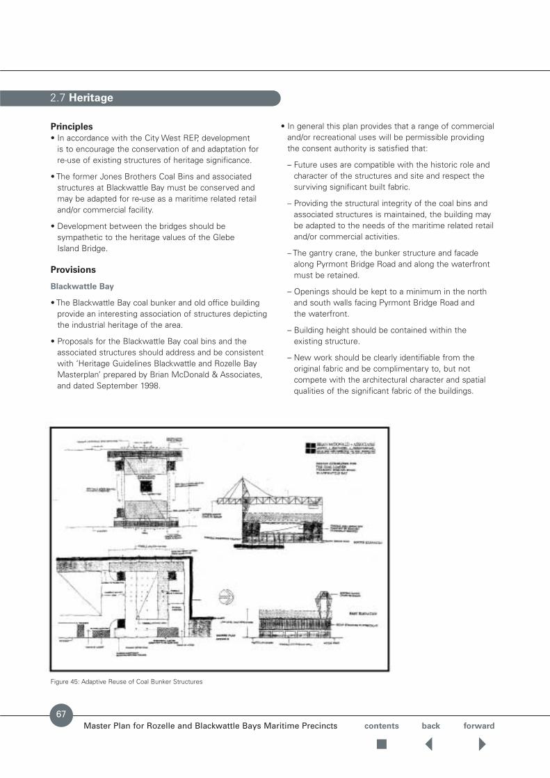
Master Plan for Rozelle and Blackwattle Bays Maritime Precincts contents back forward
Principles
• In accordance with the City West REP, development is to encourage the conservation of and adaptation for re-use of existing structures of heritage significance.
• The former Jones Brothers Coal Bins and associatedstructures at Blackwattle Bay must be conserved andmay be adapted for re-use as a maritime related retailand/or commercial facility.
• Development between the bridges should besympathetic to the heritage values of the Glebe Island Bridge.
Provisions
Blackwattle Bay
• The Blackwattle Bay coal bunker and old office buildingprovide an interesting association of structures depictingthe industrial heritage of the area.
• Proposals for the Blackwattle Bay coal bins and theassociated structures should address and be consistentwith ‘Heritage Guidelines Blackwattle and Rozelle BayMasterplan’ prepared by Brian McDonald & Associates,and dated September 1998.
• In general this plan provides that a range of commercialand/or recreational uses will be permissible providing the consent authority is satisfied that:
– Future uses are compatible with the historic role andcharacter of the structures and site and respect thesurviving significant built fabric.
– Providing the structural integrity of the coal bins andassociated structures is maintained, the building maybe adapted to the needs of the maritime related retailand/or commercial activities.
– The gantry crane, the bunker structure and facadealong Pyrmont Bridge Road and along the waterfrontmust be retained.
– Openings should be kept to a minimum in the northand south walls facing Pyrmont Bridge Road and the waterfront.
– Building height should be contained within the existing structure.
– New work should be clearly identifiable from theoriginal fabric and be complimentary to, but notcompete with the architectural character and spatialqualities of the significant fabric of the buildings.
2.7 Heritage
Figure 45: Adaptive Reuse of Coal Bunker Structures
67

2.7 Heritage cont.
Master Plan for Rozelle and Blackwattle Bays Maritime Precincts contents back forward
68
– Damaged or missing original elements of the building’sexterior and interior should be restored orreconstructed (respectively) based on accuratedocumentary and/or physical evidence in accordancewith Articles 19 and 23 of the Australia ICOMOS Burra Charter.
– To take advantage of the setting, provide generousclear openings to outdoor spaces, where the fabric hasdeteriorated beyond retention ie.on the western side of the bunker structure.
– The former weighbridge and office building frontingPyrmont Bridge Road on site B1 can be retained foradaptive reuse should this prove viable.
– Prior to excavation or disturbance of the site anExcavation Permit should be sought from the Heritage Council of NSW.
• To allow for the adaptive reuse of historical structures,non-conforming uses may be considered subject to the above.
• The heritage fabric should be retained as described bythe Conservation Management Plan prepared for theBlackwattle Bay coal bins and the associated structuresfor the former Office of Marine Administration (now partof the Waterways Authority) by Perumal Murphy Wu PtyLtd. It should be noted that these structures are notlisted as heritage items.
• The Pioneer Concrete batching plant on site B3 can beretained for adaptive reuse should this prove viable.
Rozelle Bay
• The master plan area includes the western abutment of the Old Glebe Island Bridge within its controls butexcludes the pivot structure and assumes the bridge andthe abutment remain and item of heritage significance.
• A draft Conservation Management Plan for the Bridgehas been prepared by the Department of Public Worksand Services on behalf of the Roads & Traffic Authority.

Master Plan for Rozelle and Blackwattle Bays Maritime Precincts contents back forward
Generally
Signage is a major part of the marine foreshore.The signsare sources of information, wayfinding, identification andadvertising.Numerals are often used to identify differentelements (eg: Wharf No. 7) and are of large scale so theycan be seen at a distance and because they identify largestructures.However signs should not add to visual clutterand should fit within an ordered pattern for the site.
Provisions
• Prepare signage and advertising guidelines with input from the following professional disciplines ofarchitecture, advertising, landscape, graphics, heritage and traffic safety.
SITE STRUCTURE
Objective
• Give order and structure to the site.
• Develop a hierarchy of signs to identify the site andprovide clear and consistent wayfinding.
• Signage must not obstruct views and vistas, heritageitems or landmarks identified in this master plan.
• Advertising should be clearly different from Waterwaysor information signage.
• Signage should not adversely affect the public domain by overshadowing lighting levels or visual impact.
• Develop a suite of signs by a professional graphicdesigner in line with these principles.
Provisions
• The site entry marker at Rozelle Bay should be sharedwith Sydney Ports.Waterways and Sydney Ports bothenter this site off The Crescent and should co-ordinatetheir site identification to avoid visual clutter.
• The entry marker at Blackwattle Bay should be of thesame suite as Rozelle Bay but smaller in scale.
• Direction boards should be provided near the entry pointand at major decision points within Waterways Land to aid wayfinding and minimise traffic congestion andconfusion on the site.These would schedule lessees and amenities (but exclude logos) and give direction with arrows.
• Buildings may be identified by numbers that are insequence along the site.Final numbering will bedependant upon development proposals.
• Numbers that identify marine structures or buildings,must all be of the same colour and style and should be located to be visible from land and water (maximum 2 numbers per building).
• Numbers can be large supergraphics up to 2.4m highand should be permitted on the buildings. (see Images).
• Signage should be bold and legible from the water andadjacent land (see Images).
2.8 Outdoor Advertising and Signage
Desirable building signage forms
69

LESSEE IDENTIFICATION
Principles
To identify the business or use within the overall strategysuch that it is clearly visible but does not dominate other signs.
Signage on buildings is to be integrated with thearchitecture and must be contained within its profile.
Provisions
• Free standing signage panels may be placed nearbusiness entries or next to designated waterfrontleases.These panels will be part of the overall site suite of signs and of consistent size and colour.Individual signs on logos may be placed within thepanel.All signs on street frontages at the Rozelle siteshould be a free standing rectangles 2.4 x 0.8 x 0.2m.
• Free standing, third party advertising structures are to beavoided in Master Plan area.
• Signs on buildings must be integrated with themodulation of the building eg. within the structuralframe, aligned with openings.
• Business signs must be of consistent height and sitwithin the zones shown below.
• Ensure that third party advertising is clearly differentiatedfrom Waterways Authority and leaseholder signage.
• Third party advertising should be limited to those signsthat are an integral part of their function eg: Petrol brand on pump, or brand on marine equipment.
2.8 Outdoor Advertising and Signage cont.
Master Plan for Rozelle and Blackwattle Bays Maritime Precincts contents back forward
70
Building form and signage location Rozelle Bay
Access Road
Rozelle Bay
Building form and signage location Blackwattle Bay
Blackwattle Bay
Pyrmont Bridge Road
contents back forwardMaster Plan for Rozelle and Blackwattle Bays Maritime Precincts
Principles
• The infrastructure requirements for the bay sites willhave to be coordinated with utility authorities andLeichhardt Council.
• Service augmentation should be sized, where possiblefor the ultimate usage levels.
Provisions
Foreshore Modifications
• The master plan acknowledges that to optimisewaterfront efficiency, conforming land and water uses may be required to re-shape the foreshore and/orexisting. A framework for the joint assessment of futureapplications is at Appendix A.
Easements
• Easements for services are to be provided as shown in Figure 35.
• Consult with the Sydney Harbour Foreshore Authority,concerning options for a future drainage easement in the Rozelle Bay precinct required by the redevelopmentof the Rozelle Marshalling Yards.
Sewerage
• New buildings and facilities at the eastern end of RozelleBay should be connected to the existing sewer line. Anew sewer line will be required to service the westernend of Rozelle Bay.
• New buildings and facilities at Blackwattle Bay should beconnected to the existing sewer line.
Water
• New buildings and facilities should be connected to theexisting mains in both bays.
Electricity
• Augmentation of the existing services may be requireddepending on the facilities to be established on the site.Craft repair, large craft berths and back of house charterindustry facilities will require significant power.
• The power service to the Blackwattle Bay site may beadequate although some augmentation may be requiredto service the central area.
Communications
• New buildings and facilities should be connected to theexisting services.
Gas
• New buildings and facilities should be connected to theexisting services.
2.9 Utilities and Infrastructure
71
2.10 Implementation and Phasing
Master Plan for Rozelle and Blackwattle Bays Maritime Precincts contents back forward
72
The proposed implementation strategy and redevelopmentprogram is anticipated to occur over a five year periodfrom 2002 to 2007, via a staged development of sites and precincts.
The Round One EOI invitation will allow industry groupsthe opportunity to make single or multiple site bids for sites in each of the following precincts as shown on Figures 4-9:
The staged process is required for a number of reasons including:
• Maintenance of existing Waterways Authority maritime operations.
• Allowance for existing tenancy arrangements.
• Market testing of the commercial feasibility of alternative uses.
• Market testing of private sector industry groups to fundthe capital development.
• Flexibility to adjust site areas to accommodate innovativedesigns and solutions.
• Maintenance of access to Sydney Ports CorporationWhite Bay port area.
• Infrastructure provision and site servicing.
Any non-conforming land uses are to be progressivelyexcluded from the sites. Re-development will be requiredto be carried out in an orderly and staged program, causing minimum disruption to the continuity ofconforming activities and public access during the construction process.
The existing wharves at Rozelle and Blackwattle Bays haverecently been refurbished and upgraded.The WaterwaysAuthority’s operational berthing facilities at Rozelle Bay (eg harbour cleaning) have been centralisedto maximise waterfrontage available for other maritimeoperations. Utility services at Rozelle Bay should be upgraded.
The Waterways Authority has invited Expressions ofInterest from the maritime industry to lease the varioussites in accordance with the requirements of the MasterPlan.Government should retain ownership of the land. Any required infrastructure work such as the proposedrelocation of James Craig Road would be undertakenduring construction of new maritime facilities.

Master Plan for Rozelle and Blackwattle Bays Maritime Precincts contents back forward
Appendix A
Development Proposals spanning Land and Water at Blackwattle and Rozelle Bays
Appendix B
Objectives of the Waterfront Use Zone under the City West REP
Appendix C
Public Domain Technical Standards
APPENDICES
73

APPENDIX A
Master Plan for Rozelle and Blackwattle Bays Maritime Precincts contents back forward
74
DEVELOPMENT PROPOSALS SPANNING LAND
AND WATER AT BLACKWATTLE AND ROZELLE
BAYS
Framework for joint application, exhibition and
consideration of applications requiring approval under
Part 4 and Part 5 of the Environmental Planning and
Assessment Act 1979
Many of the maritime operations anticipated in the MasterPlan will inherently involve water-side elements relating to access to the waterway and waterfront for mooring,maintenance, storage and launching of craft.
However, the waterways of Rozelle and Blackwattle Bays fall outside the boundaries of any environmentalplanning instrument.
This means that:• Environmental assessment for water-side development
is undertaken under Part 5 of the Environmental Planningand Assessment Act 1979 (EP &A Act) whereasdevelopment on the foreshore is assessed under Part 4.
• The responsible authority for waterside development is the Waterways Authority, whereas PlanningNSW isresponsible for development on the foreshore.
Nonetheless, there are a number of opportunities tointegrate the two separate processes under Parts 4 and 5 of the EP&A Act between the two State agencies. Forinstance, proposals spanning land and water areas couldhave the one environmental assessment documentprepared covering all aspects of the proposeddevelopment and satisfying the requirements of Parts 4 and 5.
Benefits include:• Encouraging comprehensive and coordinated
assessment between the two approval authorities.
• Avoiding disjointed consideration of land and watercomponents of the one development.
• Streamlining the assessment and approval process formaritime developments spanning land and water areas.
The recommended process for joint consideration ofproposals spanning land and water will involve thefollowing steps:
1. Concurrent lodgement of applications
• Total development and associated impacts addressed in the one environmental assessment document(combination of statement of environmental effects and review of environmental factors).
• If designated development, environmental impactstatement required.
2. Application referred to Leichhardt Council and other
relevant government authorities
• When advertised, nominated integrated or designated development.
3. Joint notices of public exhibition
• Ads placed in the Western Suburbs Courier, The Glebe and Inner Western Weekly and the SydneyMorning Herald, on-site notices and notification to owner and occupiers.
4. Joint public exhibition
• If advertised development, exhibited for 21 days.
• If nominated integrated or designated development,exhibited for 30 days.
5. Written submissions received and considered
• All submissions received considered by both State agencies.
• Copies of submissions forwarded to Leichhardt Council.
6. Coordinated assessment
7. Application approved or refused
• PlanningNSW proceeds to determine land-sidedevelopment under Part 4.
• Waterways Authority proceeds to determine water-sidedevelopment under Part 5.
8. Notification of decision
• The applicant, Council and submitters are advised ofeach decision by relevant State agency.

Master Plan for Rozelle and Blackwattle Bays Maritime Precincts contents back forward
OBJECTIVES OF THE WATERFRONT USE ZONE
UNDER THE CITY WEST REP
The regional planning principles identified for the Bays
Precincts include:
Roles and Land-Use Facilities
• Development should reinforce and complement the roleof the Precinct as a major inter-harbour port and maritimelocation.
• Development in the Precinct is to provide for a mixtureof commercial, port, port-related, employment,waterfront and recreational uses, but is not to include residential development.
• Development is to take full advantage of the Precinct’slocation and its infrastructure.
• Development is to encourage the environmentalrejuvenation of the Precinct.
• Development is to make efficient use for surplusGovernment owned land.
• Development is to contribute to water quality in RozelleBay and Blackwattle Bay.
• Development is to make a significant contributionecological sustainability.
• Development on the waterfront and on land adjoiningRozelle Bay and Blackwattle Bay is to enhance theenvironmental quality.
Urban Design
• Design principles should recognise the working industrialnature of the Precinct in close proximity to residential areas.
• Development along the Precinct boundary should relateto the adjoining street systems and built forms.
• Siting and form of development must consider theimpact of views into, across and out of the Precinct.
Public Domain
• Public recreation areas are to provide for arrange ofrecreational opportunities for those working in andvisiting the Precinct.
• Development siting and form must consider creating,retaining and enhancing views and vistas from the water and public domain.
• Links for pedestrians, cyclists and persons withdisabilities are to be provided.
• Safety and security issues to be addressed in thecontext of a working waterfront.
• Development should help to create a high quality public domain.
APPENDIX B
75

APPENDIX C
Master Plan for Rozelle and Blackwattle Bays Maritime Precincts contents back forward
PUBLIC DOMAIN TECHNICAL STANDARDS
Blackwattle & Rozelle Bays Public Domain Technical Standards
Ultimo Pyrmont Public Domain Technical Manual
Technical Standards Application to Blackwattle Proposed Public Domain
& Rozelle Bays MasterPlan Technical Standards
ST Streetscapes
ST 1 Design Issues
ST 1.1 Boulevards – Foreshore Zone Not applicable –
ST 1.2 Boulevards – Harris Street Not applicable –
ST 1.3 Major Streets See Major Street Cross Sections BRST 1.1 Major Streets
ST 1.4 Local Streets See Minor Street Cross Sections BRST 1.2 Minor Streets
ST 1.5 Slow Traffic Zones Applicable between sites R9 & R10 ST 1.5 (Sites R9 & R10)
ST 1.6 Through Site Links/Laneways Not applicable –
ST 2 Elements – Design Issues
ST 2.1 Kerbs & Gutters Applicable except kerb & gutters ST 2.1 (Concrete kerb & gutters)are to be concrete and not trachyteor bluestone
ST 2.2 Granite Trim Not applicable –
ST 2.3 Vehicle Crossovers Applicable except surfacing is to ST 2.3 (Asphalt crossovers)be asphalt and not granite
ST 2.4 Pedestrian Ramps Applicable except surfacing is to ST 2.4 (Asphalt pedestrian ramps)be asphalt and not granite
ST 2.5 Bluestone Rumble Strips Not applicable –
ST 2.6 Footpath Widenings, Not applicable –Thresholds, Street Closures
ST 2.7 Asphalt Applicable subject to increased ST 2.7 (Industrial design strength)design strength
ST 2.8 Service Covers Applicable ST 2.8
T Tree Planting
T 1 General Principles Applicable T 1
T 2 Tree Planting in Streets – Local street detail applicable T 2 (Local street detail)Footpaths
T 3 Tree Planting in Streets – Not applicable –Carriageways
76

Master Plan for Rozelle and Blackwattle Bays Maritime Precincts
Blackwattle & Rozelle Bays Public Domain Technical Standards
Ultimo Pyrmont Public Domain Technical Manual
Technical Standards Application to Blackwattle Proposed Public Domain
& Rozelle Bays MasterPlan Technical Standards
EN Engineering Notes
EN 1 Concrete & Sub-Grade Applicable EN 1Preparation
EN 2 Existing Services & Siteworks Applicable EN 2
EN 3 Asphalt Concrete Applicable EN 3
EN 4 Masonry Kerbs, Gutters Not applicable –
SRSteps & Ramps
SR 1 Principles Applicable SR 1
SR 2 Steps – Statutory Requirements Applicable SR 2
SR 3 Steps – Public Domain Principles Applicable SR 3
SR 4 Ramps – Statutory Requirements Applicable SR 4
SR 5 Materials Notes Applicable SR 5
WF Walls & Fences
WF 1 Retaining Walls Reinforced concrete/blockwork WF 1 (Reinforced concrete blockwork detail applicable retaining walls)
WF 2 Freestanding Walls Reinforced concrete/blockwork WF 2 (Reinforced concrete blockwork detail applicable retaining walls)
WF 3 Fences Not applicable –
WF 4 Existing Walls & Fences Not applicable –
SF Street Furniture
SF 1 Principles Applicable to permanent public SF 1 Permanent public access areasaccess areas
SF 2 Typical Layout/Range of Elements Applicable to permanent public SF 2 Permanent public access areasaccess areas
W Waters Edge
W 1 Principles Not applicable BRW 1
W 2 Typical Details Not applicable BRW 2
W 3 Existing Details Not applicable –
OS Open Spaces
OS 1 Principles Not applicable BROS 1
APPENDIX C cont.
contents back
77