Royal Saskatchewan Museum Plans/Resources/Big Chill.pdfThe scientific name for the Ice Age is the...
17
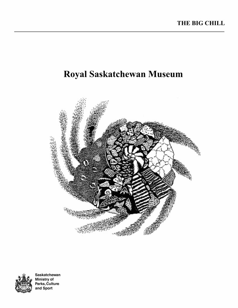
Royal Saskatchewan Museum THE BIG CHILL
Transcript of Royal Saskatchewan Museum Plans/Resources/Big Chill.pdfThe scientific name for the Ice Age is the...
Royal Saskatchewan Museum
THE BIG CHILL
THE BIG CHILL
For further information please contact:
Public ProgramsRoyal Saskatchewan Museum
2445 Albert StreetRegina, Saskatchewan
S4P 4W7Email: [email protected]
Website: www.royalsaskmuseum.ca
© Royal Saskatchewan Museum 2012
The contents of this resource package may be reproduced for classroom use only. No portion may be duplicated for publication or sale.
The following material provides teachers and students with information about the Ice Age in what is now Saskatchewan (remember, there was no such thing as Saskatchewan in those days!):
• TodescribeSaskatchewan’sclimateduringtheIceAge.
• Toillustratethegeologicaleffectsofglaciation.
• TorecognizeavarietyofanimalsthatlivedinSaskatchewanduringtheIceAge.
Vocabulary
advance geology climateglacier debris ice agedeposit drumlin eskermeltwater erratic moraineevaporation fauna retreatflora stagnant flowtill fossil Laurentide Ice Sheetknob and kettle Wisconsin Glacial Period Pleistocene Epoch
BACKGROUND INFORMATION
Ice Ages
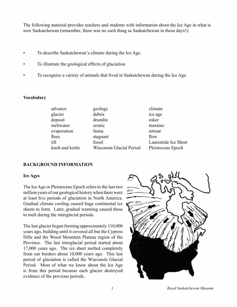
The Ice Age or Pleistocene Epoch refers to the last two million years of our geological history when there were at leastfiveperiodsofglaciation inNorthAmerica.Gradual climate cooling caused huge continental ice sheets to form. Later, gradual warming caused these to melt during the interglacial periods.
The last glacier began forming approximately 110,000 years ago, building until it covered all but the Cypress Hills and the Wood Mountain Plateau region of the Province. The last interglacial period started about 17,000 years ago. The ice sheet melted completely from our borders about 10,000 years ago. This last period of glaciation is called the Wisconsin Glacial Period. Most of what we know about the Ice Age is from this period because each glacier destroyed evidence of the previous periods.
Royal Saskatchewan Museum1
There are many theories which attempt to explain the cooling climate:
• Sunlight was blocked from reaching the earth when the sun passed through a cosmic dustcloud.
• The atmosphere did not have enough carbon dioxide to insulate the earth.• The earth “wobbled” on its axis during rotation.• Mountain building, continental drift, and water evaporation caused cooling of the earth’s polar
areas.
Glaciation
Glaciers are gigantic masses of ice which form when annual snowfall does not completely melt. Layers ofsnowbuildupyearafteryear.Snowmaymelt,refreeze,andbecoveredbymoresnow.Thepressureof the weight of succeeding layers turns the lower layers of snow to ice. At the height of the last glaciation, the continental ice sheet, called the Laurentide Ice Sheet, was approximately 3 km high. It almost completely redesigned our province, forming the rivers, valleys, and geological features of our present landscape.
Ice sheets gradually move or slip a few metres a year because of their enormous weight and the effect of meltingandfreezing.Surfacesnowmeltsandrefreezes,expandingandcontracting,andcausingcracksintheglacier.Thesecracksfillwithmeltwater.Themeltwatermayflowundertheglacierorbetweenlayers of ice within the glacier lubricating the movement of the ice. Surface ice may slip faster than the underlying ice and move off ahead of the main bulk of the glacier, picking up rocks, clay, sand, and organicmaterialinitspath.Asthemainglacierbulldozesforward,itpicksupthelighterforwardiceas if on a conveyor belt.
It may be worthwhile explaining to students that this continental glacial action affecting our province’s topography is different from alpine glaciation, which forms in mountainous terrain. Most of the thousands of glaciers in the world today are alpine glaciers; continental glaciers are rarer, larger, and comprise far more ice. At present, there are two continental glaciers in the world: the Greenland and Antarctic ice sheets.
THE EFFECTS OF GLACIAL DEVELOPMENT
Glaciers can change topography as they grow and move.
Fluting Fields and StriationsLarge boulders embedded in the ice sometimes scratch the surface of rocks lying under the glacier as it moves. These long scratches in the bedrock are called striations.
Iftheglacierismovingoverareasofsoftearth,itcanscrapethegroundflat.Thesefeaturesarecalledflutingfields.
Royal Saskatchewan Museum2
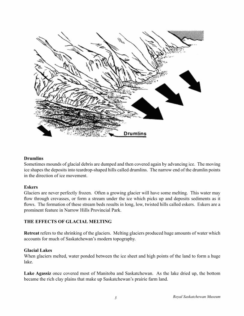
DrumlinsSometimes mounds of glacial debris are dumped and then covered again by advancing ice. The moving ice shapes the deposits into teardrop-shaped hills called drumlins. The narrow end of the drumlin points in the direction of ice movement.
EskersGlaciersareneverperfectlyfrozen.Oftenagrowingglacierwillhavesomemelting.Thiswatermayflowthroughcrevasses,orformastreamunder the icewhichpicksupanddepositssedimentsas itflows.Theformationofthesestreambedsresultsinlong,low,twistedhillscalledeskers.Eskersareaprominent feature in Narrow Hills Provincial Park.
THE EFFECTS OF GLACIAL MELTING
Retreat refers to the shrinking of the glaciers. Melting glaciers produced huge amounts of water which accounts for much of Saskatchewan’s modern topography.
Glacial LakesWhen glaciers melted, water ponded between the ice sheet and high points of the land to form a huge lake.
Lake Agassiz once covered most of Manitoba and Saskatchewan. As the lake dried up, the bottom became the rich clay plains that make up Saskatchewan’s prairie farm land.
Royal Saskatchewan Museum3
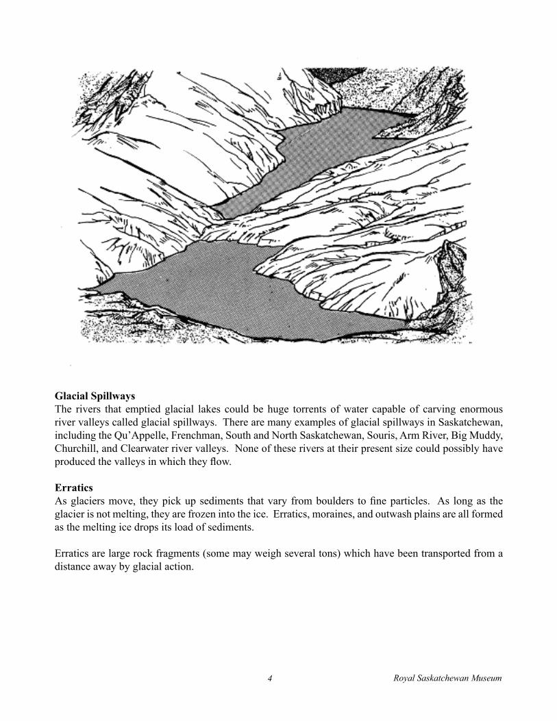
Glacial SpillwaysThe rivers that emptied glacial lakes could be huge torrents of water capable of carving enormous river valleys called glacial spillways. There are many examples of glacial spillways in Saskatchewan, including the Qu’Appelle, Frenchman, South and North Saskatchewan, Souris, Arm River, Big Muddy, Churchill,andClearwaterrivervalleys.Noneoftheseriversattheirpresentsizecouldpossiblyhaveproducedthevalleysinwhichtheyflow.
ErraticsAsglaciersmove, theypickupsediments thatvary fromboulders tofineparticles. As longas theglacierisnotmelting,theyarefrozenintotheice.Erratics,moraines,andoutwashplainsareallformedas the melting ice drops its load of sediments.
Erratics are large rock fragments (some may weigh several tons) which have been transported from a distance away by glacial action.
Royal Saskatchewan Museum4
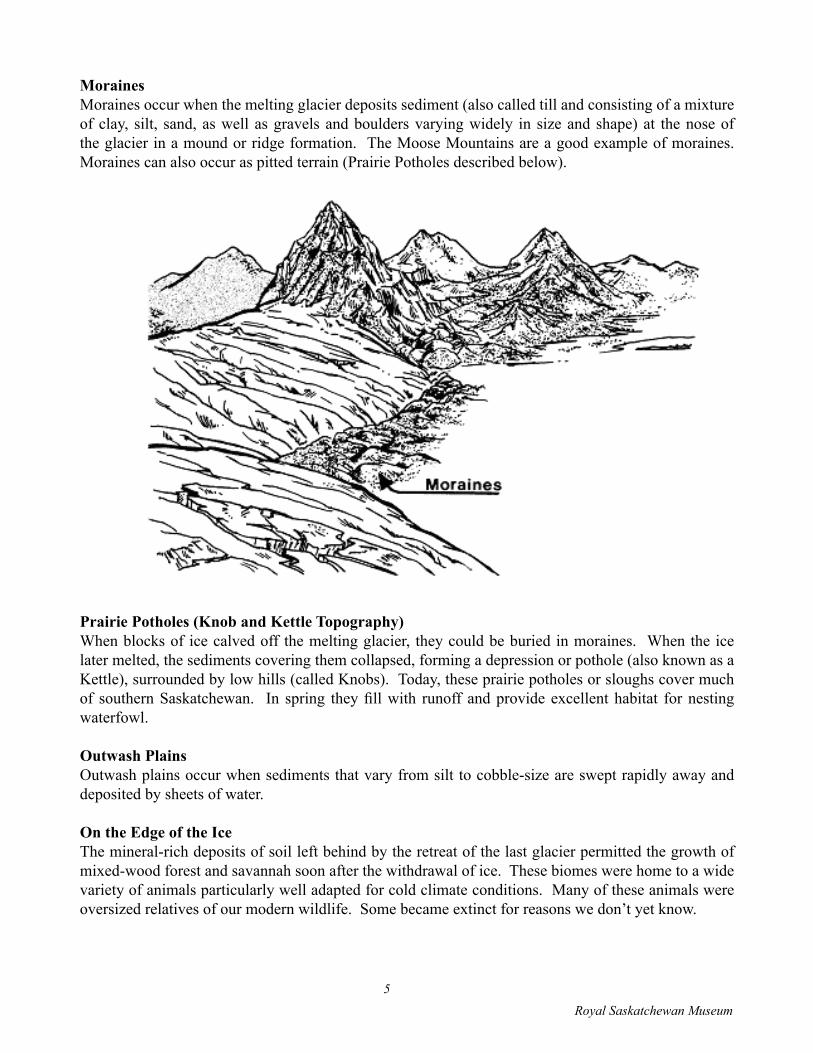
MorainesMoraines occur when the melting glacier deposits sediment (also called till and consisting of a mixture ofclay, silt, sand,aswellasgravelsandbouldersvaryingwidely in sizeandshape)at thenoseofthe glacier in a mound or ridge formation. The Moose Mountains are a good example of moraines. Moraines can also occur as pitted terrain (Prairie Potholes described below).
Prairie Potholes (Knob and Kettle Topography)When blocks of ice calved off the melting glacier, they could be buried in moraines. When the ice later melted, the sediments covering them collapsed, forming a depression or pothole (also known as a Kettle), surrounded by low hills (called Knobs). Today, these prairie potholes or sloughs cover much of southernSaskatchewan. In spring theyfillwith runoff andprovideexcellenthabitat fornestingwaterfowl.
Outwash PlainsOutwashplainsoccurwhensedimentsthatvaryfromsilttocobble-sizearesweptrapidlyawayanddeposited by sheets of water.
On the Edge of the IceThe mineral-rich deposits of soil left behind by the retreat of the last glacier permitted the growth of mixed-wood forest and savannah soon after the withdrawal of ice. These biomes were home to a wide variety of animals particularly well adapted for cold climate conditions. Many of these animals were oversizedrelativesofourmodernwildlife.Somebecameextinctforreasonswedon’tyetknow.
Royal Saskatchewan Museum5
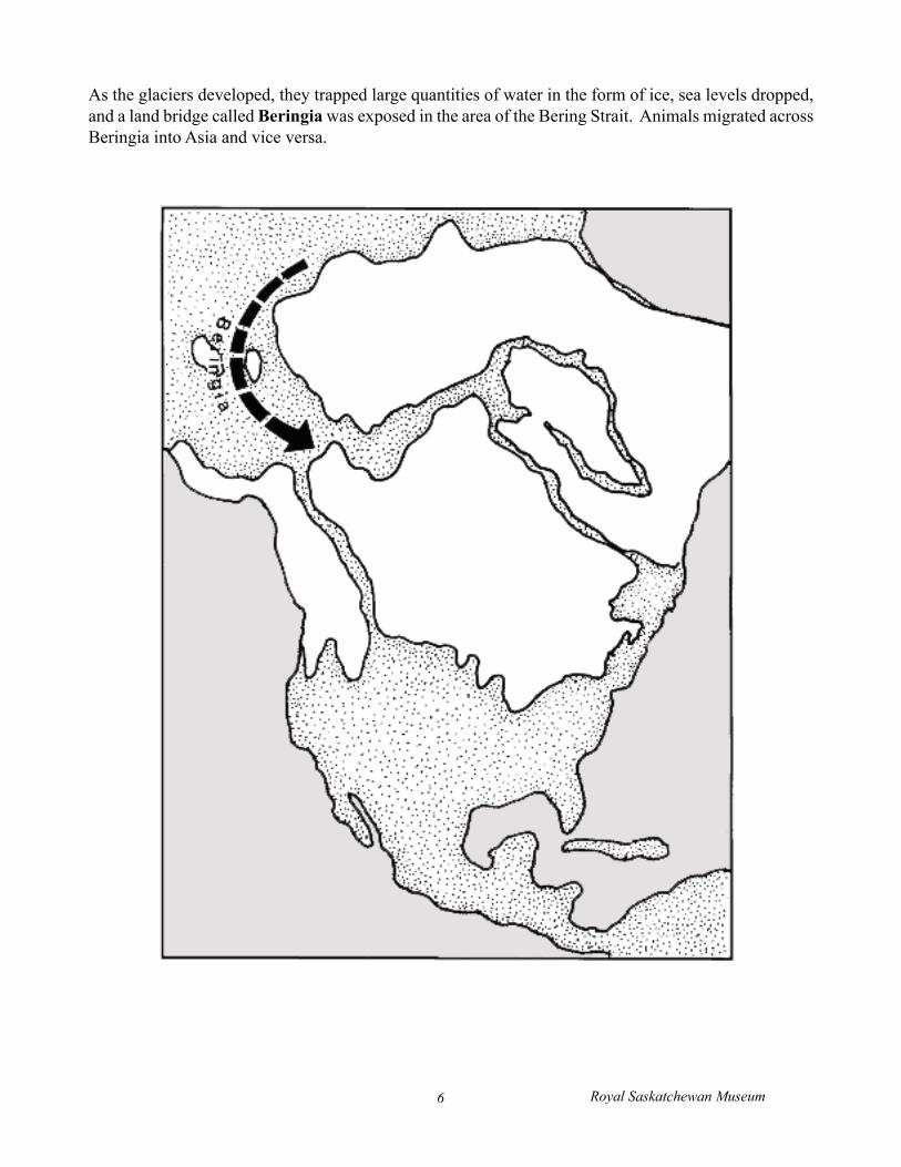
As the glaciers developed, they trapped large quantities of water in the form of ice, sea levels dropped, and a land bridge called Beringia was exposed in the area of the Bering Strait. Animals migrated across Beringia into Asia and vice versa.
Royal Saskatchewan Museum6
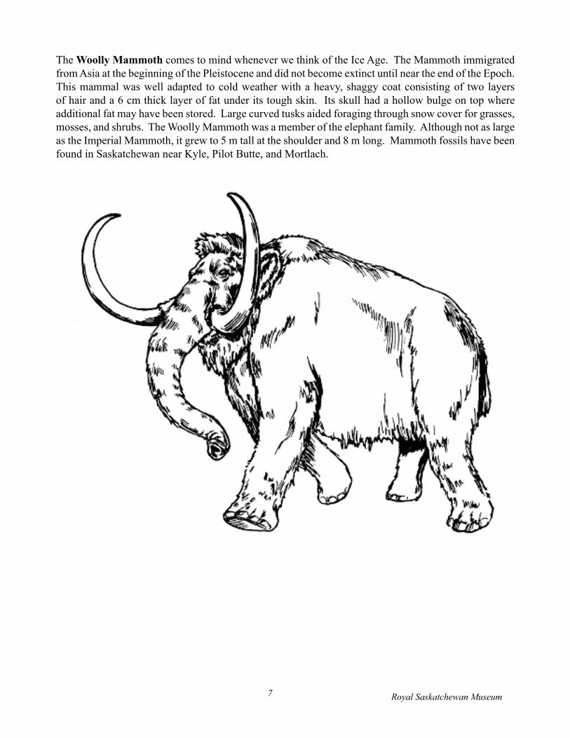
The Woolly Mammoth comes to mind whenever we think of the Ice Age. The Mammoth immigrated from Asia at the beginning of the Pleistocene and did not become extinct until near the end of the Epoch. This mammal was well adapted to cold weather with a heavy, shaggy coat consisting of two layers of hair and a 6 cm thick layer of fat under its tough skin. Its skull had a hollow bulge on top where additional fat may have been stored. Large curved tusks aided foraging through snow cover for grasses, mosses, and shrubs. The Woolly Mammoth was a member of the elephant family. Although not as large as the Imperial Mammoth, it grew to 5 m tall at the shoulder and 8 m long. Mammoth fossils have been found in Saskatchewan near Kyle, Pilot Butte, and Mortlach.
Royal Saskatchewan Museum7
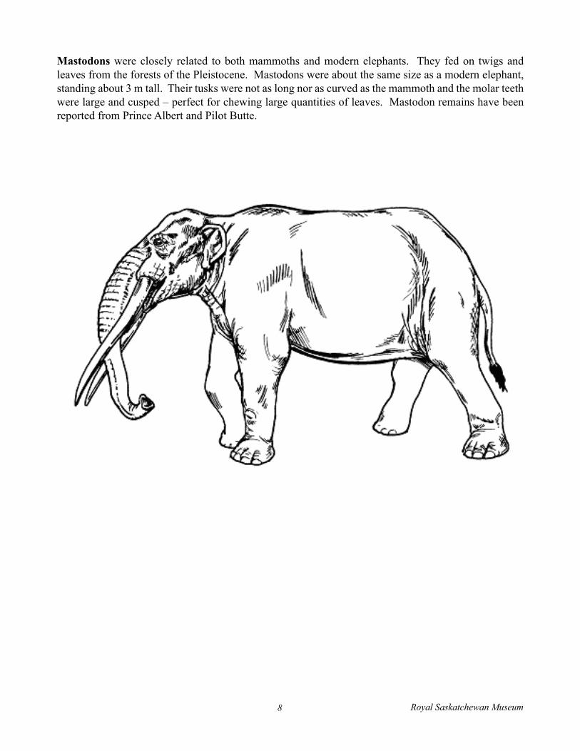
Mastodons were closely related to both mammoths and modern elephants. They fed on twigs and leavesfromtheforestsofthePleistocene.Mastodonswereaboutthesamesizeasamodernelephant,standing about 3 m tall. Their tusks were not as long nor as curved as the mammoth and the molar teeth were large and cusped – perfect for chewing large quantities of leaves. Mastodon remains have been reported from Prince Albert and Pilot Butte.
Royal Saskatchewan Museum8
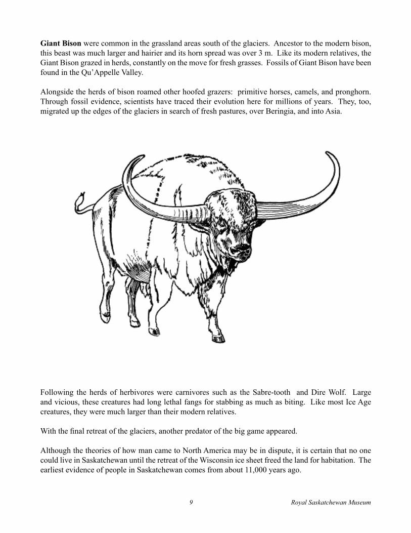
Giant Bison were common in the grassland areas south of the glaciers. Ancestor to the modern bison, this beast was much larger and hairier and its horn spread was over 3 m. Like its modern relatives, the GiantBisongrazedinherds,constantlyonthemoveforfreshgrasses.FossilsofGiantBisonhavebeenfound in the Qu’Appelle Valley.
Alongsidetheherdsofbisonroamedotherhoofedgrazers:primitivehorses,camels,andpronghorn.Through fossil evidence, scientists have traced their evolution here for millions of years. They, too, migrated up the edges of the glaciers in search of fresh pastures, over Beringia, and into Asia.
Following the herds of herbivores were carnivores such as the Sabre-tooth and Dire Wolf. Large and vicious, these creatures had long lethal fangs for stabbing as much as biting. Like most Ice Age creatures, they were much larger than their modern relatives.
Withthefinalretreatoftheglaciers,anotherpredatorofthebiggameappeared.
Although the theories of how man came to North America may be in dispute, it is certain that no one could live in Saskatchewan until the retreat of the Wisconsin ice sheet freed the land for habitation. The earliest evidence of people in Saskatchewan comes from about 11,000 years ago.
Royal Saskatchewan Museum9
The Legacy of the Ice AgeThe glaciers completely obliterated the landscape of other eras, grading the topography, scraping minerals from the Precambrian Shield, grinding down the rocks and mountains, cutting rivers into the plains,dumpinghills,floodingtheplainswithlakes,cuttingvalleyswithrivers,andcreatingdepositsofnutrient-rich sediments on the Plains. The land is what the glaciers left behind, but the current climate has been affected by other elements: the rise of the Rocky Mountains, the winds from the Gulf Stream, andthebiologyoffloraandfauna.
FREQUENTLY ASKED QUESTIONS:
What is the scientific name for the Ice Age? How long did it last?ThescientificnamefortheIceAgeisthePleistoceneEpoch,whichlastedforabout2millionyears.ThePleistocene glaciers mark the end of the Tertiary Period and the beginning of the Quaternary Period.
How many glaciers occurred during the Ice Age?Therewerefivecontinentalicesheets.
What is a glacier and how does it occur?A glacier is a build-up of snow that does not melt during the warmest part of the year, creating a snowfield.Asthesnowcollects,theincreasedweightturnsthelowerlayerstoice.Whenthesnowfieldgrowslargeandheavyenough,icewillflowawayfromthecentre,creatingamoving,growingglacier.
What parts of Saskatchewan were covered with ice during the last period of glaciation?All of Saskatchewan, except for the Cypress Hills and Wood Mountain Plateau, was covered. These two areas were like islands in a vast sea of ice.
How do glaciers change the land when they move?Advancingglacierspickedupexistingsedimentoffthesurfaceandfrozeitintotheice.Whentheglaciermelted, it dropped this material in a different location (forming moraines and erratics, for example). Drumlins and eskers also formed under the ice as it moved.
In addition, the grinding, gouging, and scraping action caused by the movement of glacial ice armed withrockfragmentsfrozenintoit,createdflutingfieldsandstriations.
How does meltwater running off a glacier change the land?Water is one of the most dynamic forces causing topographical change. As the glaciers melted, huge lakes formed at the nose of the ice. Torrents of meltwater eroded deep valleys and deposited sediments melted out of the glacier.
Royal Saskatchewan Museum10

What was the environment like in what is now southern SK about 1,500,000 years ago?It was a dry environment. A cold glacial lake not shown in the diorama was located close by. This provided a source of water to support many animals. A similar situation exists today around watering holes in the African savannah.
What animals lived in this region?Giant SlothImperial MammothBone-crushing DogWhite-tailed Prairie DogCamelBobcatShrub-oxHorseFour-horned Pronghorn
Some animals that lived during the ice age went extinct, others continue to live in other parts of the world but no longer here in SK, and some still live here:? live today?
Extinct: Camel: Horse:
Giant Sloth, Imperial Mammoth, Bone-crushing Dog, Shrub-ox SK during ice age, now still live in AfricaSK during ice age, went extinct and then modern horses were introduced to N. America with arrival of Europeans.
Prairie Dog: still in Saskatchewan/N. AmericaBobcat: still in Saskatchewan/N. AmericaPronghorn: still in Saskatchewan/N. America
Describe a mammoth.A mammoth is very similar to an elephant and is related to it. There are differences, however: mammoths hadbiggertusks;theyhadathickcoatoffur;theirheadshadahollowdomethatcouldfillwithfat;theirears were much smaller than modern elephants, in order to conserve body heat.
Royal Saskatchewan Museum11
Esker, drumlin, valley, moraine, spillway, lake, potholes. Which were formed by ice, which by meltwater?
Esker: Drumlin: Valley: Moraine: Spillway: Lake: Potholes:
IceIceIn Saskatchewan, the valleys were formed by meltwater. IceMeltwaterMeltwaterBoth ice and meltwater
How was the Giant Bison different from a modern bison? How are they similar?Differences: Horns much bigger
Animal was bigger
Similarities: Humps
Diet of grasses Shape of body Hooves
Why did it become extinct?The Giant Bison (Bison latifrons) evolved into the familiar form that we know today. It became extinct through evolution.
Royal Saskatchewan Museum12

ACTIVITIES - Geological Time ChartPut the following phrases under the correct heading:
Before Ice Age During Ice Age After Ice AgeGlacial LakeDire WolfDinosaursPronghornPrairie GrassIce sheetsGiant BisonFertile soilFirst Nations PeopleQu’Appelle ValleyTropicalMorainesWoolly MammothShallow tropical seasCold weatherCamelVolcanoesSouth Sask. RiverMoraineSwampsPrecambrian ShieldLakeAgassizGlacial tillRailroadIrrigationLake DiefenbakerTundraMeltwaterMineral depositsFarmsBeringiaReginaFossilsDrumlins
Royal Saskatchewan Museum13
Meltwater LayeringThis experiment illustrates the effect of water on layering of sand and dirt.
Equipment:a clean jarsanddirtwater
Method:Inaclearglassjarputenoughdirttocoverthebottom(about3cm).Addenoughsandtofillanother3cm. Add water to the jar to a level of 5 to 10 cm above the dirt and sand.
Stir well. Allow to settle. As the water slows down it should deposit the sand, silt, and clay into at least twoormoreclearlydefinedlayers.Aretheheavierparticlesatthetoporthebottom?Why?Underwhatconditionswouldthelightestlayersbedeposited?
Knobs and Kettle FormationThis experiment will illustrate on a small scale the process by which glacial kettles were formed.
Equipment:a shallow tray (about 6 cm thick)about 4 to 8 ice cubessand or dirt
Method:Put down a layer of sand or dirt about 2 cm thick in the bottom of the tray. Place ice cubes in different locations on the sand or dirt in the tray. Pour in more sand and dirt in the tray until the ice cubes are barely covered with a layer about .5 cm thick. Level off. Leave the ice cubes to melt. Depending on the temperature and the thickness of the covering, this should take about 4 to 8 hours. When the ice cubes melt,thefirstcoveringshouldcavein,leavingahollowinthesurface.
Glacier SimulationThis experiment will simulate glacier movement.
Equipment:water corn starch/icing sugarmixing bowlflatboardorcookiesheetsmallamountsoffinesand,pepper,sugar,etc.
Method:Mix 1/2 cup (125 ml) of corn starch with water to make a paste about the consistency of cream (corn starchbehavesinapeculiarmannerand,althoughitappearsandfeelslumpy,itwillpoureasily).Usingthe board to simulate North America (even draw a representative shape if you wish), pour the mixed corn starch on the board (in the Hudson Bay region if you drew a map).
Royal Saskatchewan Museum14
Scatter bits of sand and pepper on the board. Sprinkle a few grains of pepper on the corn starch. Tilt the board slightly and watch for the following:
1. How the mixture moves.2. Wheredoesitmovefastest?3. Whathappenswhenitmeetsaparticleofsand?4. Whathappenstothepepperontopofthecornstarch?5. Whathappensattheedgeoftheflowingmixtureandwhathappenstothemixtureatthe
centre?6. Whathappenswhenyouaddmorecornstarch?
Not Another Ice Age!Have students collect articles on the theories of the cause of the Ice Age and on whether the present period is a period of retreat or advance of an Ice Age. Start a bulletin board or resource area to display these articles.
Take a Field TripAneffectivewaytostudygeologyis totakeafieldtripandexaminethegeologicalhistoryofyourlocality. Saskatchewan has a wealth of Ice Age formations. Maps and brochures are available from universities, government departments, and museums.
Student assignments could include:1. Researching when the last glacier retreated from your area.2. Determining what local geological formation (valleys, rivers, moraines) resulted from
glaciation.3. Making sketches or photographing local geological features.4. Analysingfieldstonestoexaminehowtheydifferfrombedrockandwhethertheywere
transported by ice or water.
Ice Age MigrantsHave each student prepare a description and sketch of an animal that lived in Saskatchewan during the Ice Age, i.e. Woolly Mammoth, Imperial Mammoth, Mastodon, Giant Sloth, Shrub-ox, Peccary, Prairie Dog, Pocket Gopher, Horse, Yesterday’s Camel, Pronghorn, Lynx, Muskox, Giant Bison, Mexican Ass, Dire Wolf, North American Lion, Giant Beaver, Sabre-tooth, Crane, Stag Moose, Giant Elk, Bone-crushing Dog, Bobcat.
As a class project, prepare an Ice Age map of the world. Place the pictures of the animals on the map withlinesofcolouredwooltoindicateinwhatpartoftheworldtheyoriginated.Besuretoemphasizethat the land bridge, Beringia, allowed animals to move between continents
Royal Saskatchewan Museum15


![Computed tomography reveals hip dysplasia in Smilodon ... · 54 predators from the late Pleistocene epoch, if not across the entire history of fossil 55 mammals [1]. Much of our knowledge](https://static.fdocuments.net/doc/165x107/5f0449ef7e708231d40d3d5c/computed-tomography-reveals-hip-dysplasia-in-smilodon-54-predators-from-the.jpg)