Roundtable on Sustainable Palm Oil New Planting Procedure ... RSPO_NPP HCV and SEIA...
36
Roundtable on Sustainable Palm Oil New Planting Procedure Summary Report of HCV and SEIA Assessment Sg. Kubud Estate Keresa Plantations Sdn Bhd, Lavang District, 97000 Bintulu, Sarawak, Malaysia
Transcript of Roundtable on Sustainable Palm Oil New Planting Procedure ... RSPO_NPP HCV and SEIA...
Roundtable on Sustainable Palm Oil
New Planting Procedure
Summary Report of HCV and SEIA
Assessment
Sg. Kubud Estate
Keresa Plantations Sdn Bhd,
Lavang District, 97000 Bintulu,
Sarawak, Malaysia

2
List of Content Page
1. Executive Summary................................................................................................. 3 1.1 Summary of Assessment Finding............................................................... 3 1.2 Assessment Result…………………………………………….................…… 3 1.3 The Retrospective HCV Assessment…………………………..............…… 4
2. Scope Of The SEIA & HCV Assessment……………………………….................…. 4 2.1 Organisational Information & Contact Person……………….............…….. 4 2.2 List Of Legal Documents, Regulatory Permit & Property Deed Related To The Areas Assessed………………………..............…………… 4 2.3 Locations Maps………………………………………………..................……. 6 2.4 Area Of New Planting & Time-Plan For New Planting………..............…… 10
3. Assessment Process & Procedure........................................................................... 11 3.1 Assessor & Their Credential………………………………..................……… 11 3.1.1 High Conservation Values Assessment...................................................... 11 3.1.2 Social and Environment Impact Assessment.............................................. 14 3.2 HCV Assessment Method…………………………………………...........……. 16
4. Summary of Assessment Findings…....................................................................... 21 4.1 Summary from SEIA Assessment Findings................................................ 21 4.2 Summary from HCV Assessment Findings................................................. 22
5. Summary of the HCV Management Recommendation............................................ 26
6. Formal Signing Off By Assessor & Company……................................................... 31 7. Appendix………………………………………………….......................……………..... 32 – 34
Figures
Figure 1: Company’s location in Lavang Land District, Bintulu, Sarawak, Malaysia........... 6 Figure 2: Landscape map of Sg. Estate Kubud................................................................... 7 Figure 3: Landscape map of Sg. Estate Kubud................................................................... 8 Figure 4: Satellite Imaginary of Sg. Kubud Estate............................................................... 9 Figure 5: Map of development area of Sg. Kubud Estate.................................................... 10 Figure 6: HCV Map.............................................................................................................. 32 Table Table 1: Assessment team expertise and HCV assessment focus...................................... 11 Table 1b: List of EIA consultants.......................................................................................... 14 Table2: Interpretation of HCV, Sub-Values and descriptions in Malaysia............................ 16 Table 3: Identification and Analysis of HCVs Presence in the area of Sg. Kubud Estate..... 23
3
1. Executive Summary
1.1. Summary of Assessment Finding • Keresa Plantations Sdn Bhd is a company engaged in oil palm plantations and milling located
in the Lavang Land district, Sebauh sub-district, Bintulu, Sarawak, Malaysia. Keresa has committed to meet the RSPO principles and criteria to support the sustainable management of oil palm plantations. RSPO approved the company's membership (No.100770900000) on June 03, 2009. This marked an important landmark and set a new vision for Keresa Plantations to be a responsible producer of crude palm oil.
• Keresa has also invested by renting a piece of land of ±3,558.00 ha (NCR Land) from local community next to the plantation. Planting commenced at the end of 2012 and expected to mature at the end of 2015.
• At present, the entire NCR project area is claimed as Native Customary Right (NCR) land by the local villagers from Rumah Iba and Rumah Lawai. Currently, there are two Memorandum of Agreement documents for a 30 year lease period, signed between the two long houses mentioned above with Keresa Plantations Sdn Bhd dated December 21, 2011 and August 06, 2012.
• Keresa Plantations Sdn Bhd has the following list of legal documents related to the area assessed:
a) Environmental Impact Assessment: The Proposed Sg. Kubud Estate, Lavang land district, Sebauh sub-district, Bintulu, Sarawak. June, 2012
b) Memorandum of agreement document with the 2 long houses dated December 2011 and August 2012.
• The project site is located in Bintulu District of Bintulu Division in the Sebauh sub-district. The plantation area of Sungai Kubud Estate is situated approximately 85km from Bintulu town. Access to the plantation is via sealed road from Bintulu on the Bintulu-Miri Road heading north east. At the Simpang Bakun junction, the road then heads in the south easterly direction until turning to the plantation followed by estate road which is maintained by the plantation. The current access is via Keresa Plantations Sdn Bhd, viz Sujan Estate and Jiba Estate.
• The project site is bordered in the north with Sarawak Oil Palms Berhad plantation, and in the south west with Jendela Padu Sdn Bhd an oil palm plantation, in the south east with Acacia mangium plantation. Long houses which are located in the north of the project site are Rumah Iba and Rumah Lawai, while Rumah Majang and Rumah Desmond are generally located in the south of the project area.
• The land area of the project site of Sungai Kubud Estate is approximately located between longitudes 113o 24.00’ E – 113o 30.00’ and longitudes 3o 05.600’ N – 3o 08.800’N of the equator.
1.2 Assessment Result
4
Sg. Kubud Estate opted to conduct Retrospective HCV Assessment by Envirologic Consulting auditors. The auditors has conducted their field study in the project area and visited the local people from both Rh Iba and Rh Lawai. They also organised stakeholders meeting and discussion with Assistant General Manager, Senior Estate Manager, Acting Estate Manager and other staff during the audit The SEIA conducted by government (Natural Resources and Environment Board) approved consultants as well as the Retrospective HCV and SIA assessments conducted by RSPO approved assessors and Team Leader. Sg. Kubud Estate has adhered to RSPO New Planting Procedure and documented the assessments and plans are comprehensive and professionally carried out according to RSPO requirements and comply with the applicable RSPO Principles, Criteria and Indicators for new planting.
1.3 The Retrospective HCV Assessment by Envirologic Consulting auditors has identified and confirms that no primary forest was found within the development area. Area required maintaining or enhancing under HCV and peat was identified and included in this summary report. The whole piece of land is belongs to the local communities and leased to Keresa Plantation through legal agreement.
2. Scope of the SEIA and HCV Assessment: 2.1 Organisational Information/Contact Person
Company Name : Keresa Plantations Sdn Bhd
Address : P.O.Box 2067, 97000 Bintulu, Sarawak, Malaysia. Head Quarters Level 5, Tun Jugah Tower, Jalan Tunku Abdul Rahman, 93100 Kuching, Sarawak, Malaysia.
Contact Person : Abdul Aziz bin Zainal Abidin
Status Business Land : Oil Palm Plantation
New Planting Area : 3,558 Ha
2.2 List of Legal Documents, regulatory permits and property deeds related to the areas assessed.
Keresa Plantations Sdn Bhd has the following list of legal documents related to the area assessed:
5
a) Term of Reference submission to Natural Resources and Environmental Board Sarawak reference CK/EV 103-559/0001/12 dated 6 January 2012. b) Letter from Natural Resources and Environment Board Sarawak reference NREB/6-1/2G/48: Discussion on the Term of Reference dated June 2012. c) Final Environmental Impact Assessment: The Proposed Sg. Kubud Estate, Lavang land district, Sebauh sub-district, Bintulu, Sarawak. 13 June, 2012. d) Memorandum of agreement document with the 2 long houses dated December 2011 and August 2012 for leasing the NCR land.
e) FPIC Process Documents:
i) Consultation with long house communities on the leasing proposal conducted on September and October 2011. Report dated 4 October 2011 by Wild Asia. ii) Follow up Consultation with long house communities dated 16 – 17 February 2012 by independent consultant from Tenaganita. iii) Follow up Consultation with long house communities dated 29 August 2012 by Wild Asia. iv) Satisfactory survey and consultation with long house on the proposed lease agreement dated 30 August 2013 by Wild Asia.
6
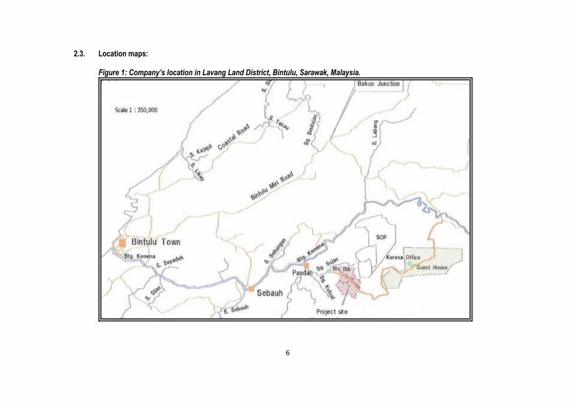
2.3. Location maps:
Figure 1: Company’s location in Lavang Land District, Bintulu, Sarawak, Malaysia.
7
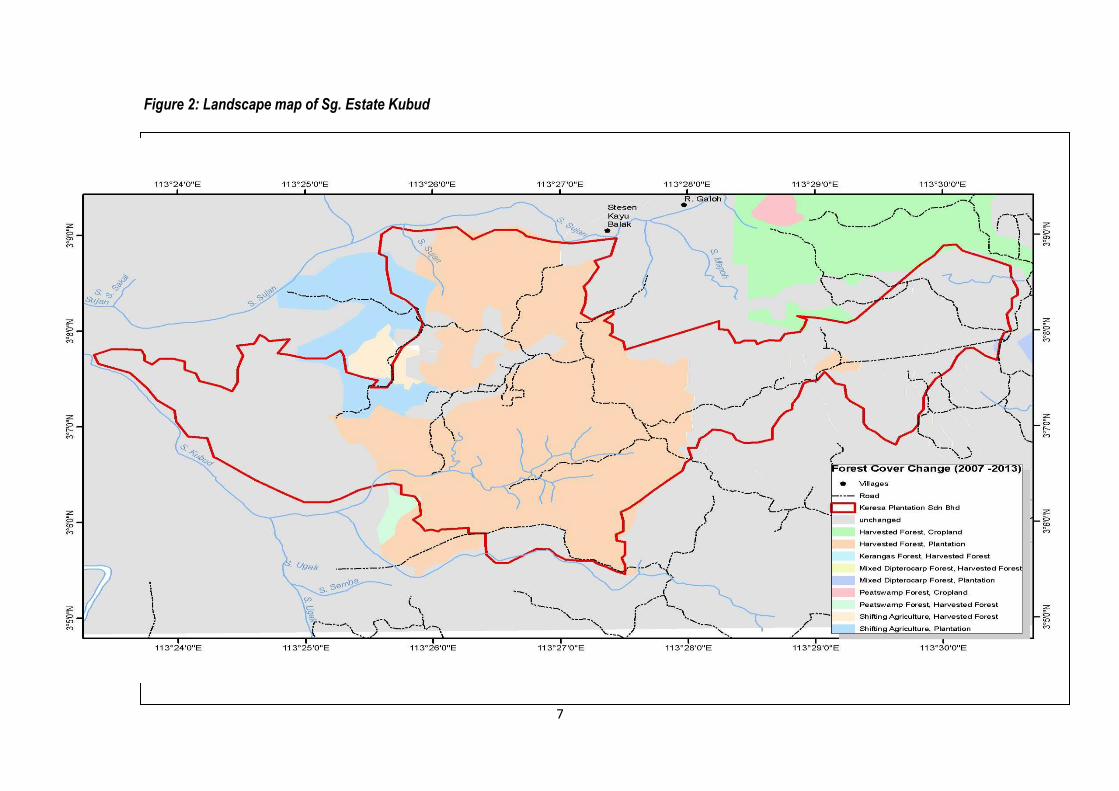
Figure 2: Landscape map of Sg. Estate Kubud
8
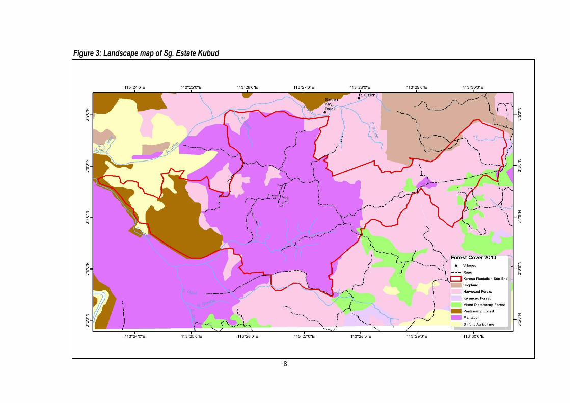
Figure 3: Landscape map of Sg. Estate Kubud
9
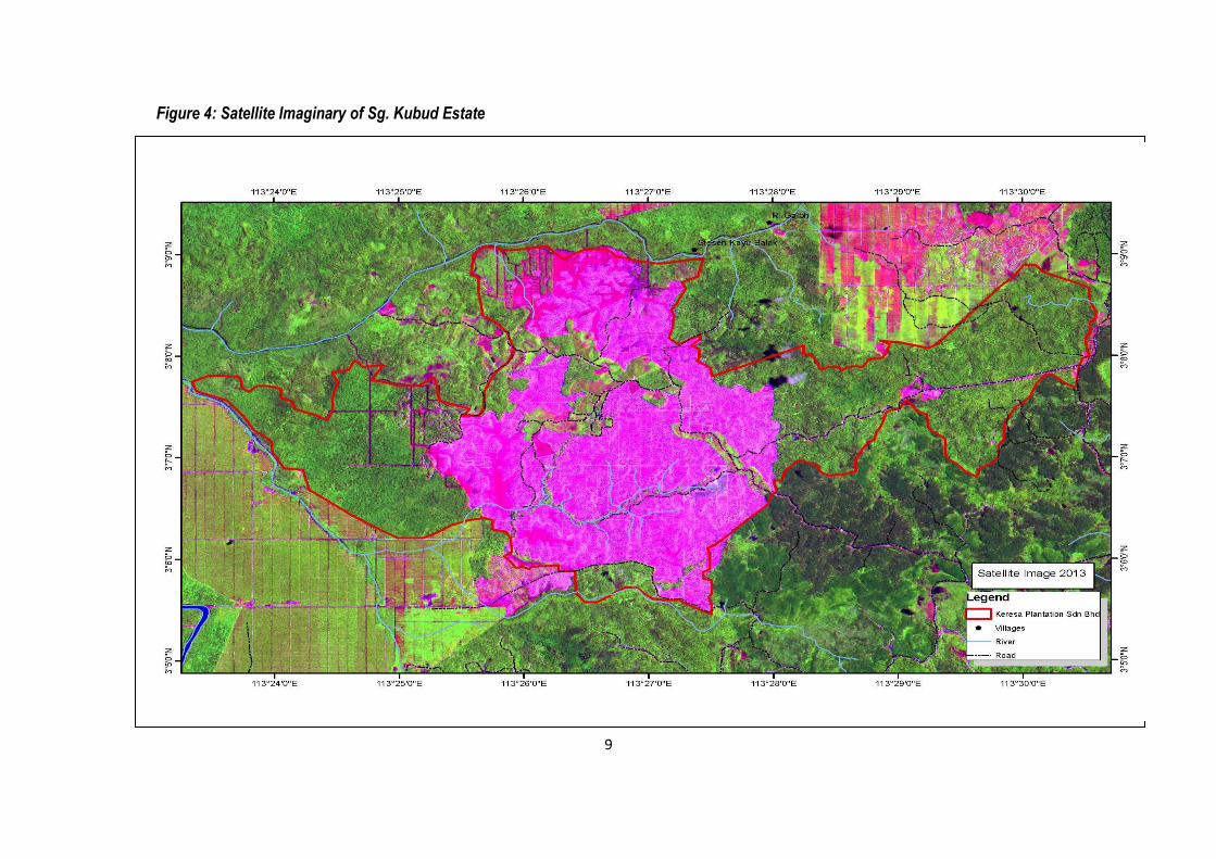
Figure 4: Satellite Imaginary of Sg. Kubud Estate
10
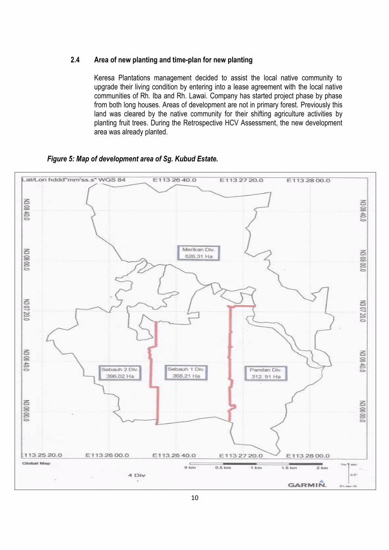
2.4 Area of new planting and time-plan for new planting
Keresa Plantations management decided to assist the local native community to upgrade their living condition by entering into a lease agreement with the local native communities of Rh. Iba and Rh. Lawai. Company has started project phase by phase from both long houses. Areas of development are not in primary forest. Previously this land was cleared by the native community for their shifting agriculture activities by planting fruit trees. During the Retrospective HCV Assessment, the new development area was already planted.
Figure 5: Map of development area of Sg. Kubud Estate.
11
3. Assessment Process and Procedure 3.1 Assessor and Their Credential 3.1.1. High Conservation Value Assessment
Envirologic Consulting (001674865-K) 18 Jalan 20/2, Paramount Garden, 46300 Petaling Jaya
Selangor Darul Ehsan, Malaysia Tel/Fax : + 603-7960 5601 E-mail: [email protected], [email protected] Website: www.kenviro.com Assessor Team
EnviroLogic Consulting assembled a team with expertise in forestry, botany and wildlife
ecology and social science to conduct the Retrospective HCV assessment. The
team’s specialization covers tropical rain forest management and wildlife ecology and
the socio-cultural economics of village communities. The background experience and
core competencies of the HCV assessors responsible for carrying out the
Retrospective HCV assessment are summarized in the following bio-data and Table 4
indicates the Retrospective HCVs that they are specialized in.
Table 1: Assessment team expertise and HCV assessment focus
Name Field of Expertise HCV aspect
Dr. Sanath
Kumaran
Biodiversity, wildlife ecology HCV 1, 2, 3, 4 (RSPO
Approved Team Leader)
Ken Yeong Bioremediation and restoration Assistant Team Leader
Ernest Chai Forestry, Field botany,
Ecology
HCV 1, 2, 3
Rantai Ak Jawa Forestry, field botany HCV 1, 3, 4
Selvanathan G Sociological/cultural
assessment
HCV 5, 6 (RSPO
Approved Assessor)
Team Leader Sanath Kumaran, PhD. Dr. Sanath Kumaran has 17 years professional working experience in natural
resources conservation and management in Malaysia, Indonesia, Cambodia and
Papua New Guinea. He is a conservation planning expert with EnviroLogic Consulting,
an international specialist consultancy based in Petaling Jaya, Malaysia and has field
experience in High Conservation Value assessment, development of management

12
plans and monitoring indicators. He is an approved RSPO HCV Assessor. He has
vast working experience in scientific fieldwork and policy level on natural resources
management and community based natural resource management. Dr. Kumaran has
worked in the field and as an agronomist with oil palm companies. He has also served
WWF-Malaysia in various projects related to forest conservation, forest certification
and forest trade network. He has experience in wetlands ecology while working with
Wetlands International and has worked with various government agencies to promote
conservation and sustainable use of forest, oil palm and freshwater resources in a
rational manner with multi-stakeholder participatory approach. His expertise also
includes capacity building of local community on policy advocacy to lobby for co-
management of natural resources and has extensive advisory experience concerning
policy issues across forest, oil palm and freshwater thematic areas of work. He has a
B. Agric. Sc. (Soil Science), MPhil (Environment and Natural Resources Management)
and PhD (Cloud forest hydrometeorology) and has published more than 20
publications and technical papers on forest conservation, wildlife assessment and
monitoring, hydrology and forest certification. His has a keen passion in leadership
training, adult & youth experiential learning, specifically developing effective leadership
capabilities. He brings considerable forest and wetlands conservation and
management experience to the team. Dr. Sanath Kumaran can be contacted at No.
18, Jalan 20/2, Paramount Garden, 46300 Petaling Jaya, Selangor, Malaysia and
Ken Young-Team Member
Ken has over 10 years of experience in management, particularly in project
development and management, marketing and now environment. He has worked with
HCV assessments and smallholder baseline studies for commodity crops in Malaysia,
Southeast Asia and Africa. He is currently an Associate Technical Manager with Wild
Asia. His area of specialization involves optimizing socio-ecological outcomes in
complex projects with multi-stakeholder engagements. He is familiar with fields of
knowledge in tropical ecology, community natural resource management, complexity
and resilience theories, environmental ethics and landscape conservation, restoration
and management.
Ernest Chai-Team Member
Mr. Ernest Chai has an MPhil degree and B.Sc. Forestry. In the past 30 over years, he
has served with the Forest Department Sarawak as an Executive Forester and has
been involved in numerous national and international projects, including ITTO Model
Forest Management Area (MFMA) on Plantation, The Netherlands-Malaysia
sustainable management of Peat Swamp Forests with specific reference to Ramin,
Sarawak Indigenous Tree Centre (SITC) at Tatau, Sarawak, and the establishment of
52ha long term ecological research plot at Lambir National Park. He is also a part-time
Auditor with SIRIM, SGS and SCS on forest management certification and was ex-
13
NREB of Sarawak as a Forestry EIA Consultant. At present he is a manager and
company director for a forestry consulting firm in Sarawak. He brings with him
knowledge on silviculture, sustainable forestry practices and development of forest
management plans.
Rantai Jawa-Team Member
En. Rantai has an overall of 30 years work experience with Forest Department
Sarawak in plant specimen collection and identification and working in the Herbarium.
He has also been involved in an ITTO project in the establishment and assessment of
ecological plots, and the establishment of Gene Bank Plot in Lanjak Entimau Wildlife
Sanctuary, Sarawak. He has been with Sarawak Forestry Corporation since 2006
involved in HCVF assessment and collection of plant specimens throughout Sarawak.
In 2007, he co-authored a book titled, “A New Check List of the Trees of Sarawak” with
Dr. Paul Chai. En. Rantai Jawa now lives in Kuching, Sarawak.
Selvanathan Grapragasem-Team Member
Mr. Selvanathan Grapragasem has an overall of 22 years working experience, in which
for the past 7 years in social accountability and also in quality, environment, health and
safety management in Malaysia and Indonesia. He is a social expert and has worked
with AgroVet Certification [RSPO Certification] of Austria, ALGI International [Global
Social Compliance] of New York, USA and 4D Consultant [Social Accountability] of
India. He has vast working experience in fieldwork and policy level on social
management and community based social resource management. Mr Selvanathan
has worked with various agencies to promote social sustainable use of forest and oil
palm in a rational manner with multi-stakeholder participatory approach. He has a
Diploma in Agriculture and Degree in Business Management and has audited more
than 20 organizations and is an approved HCV assessor of RSPO and focusses on
sociological and cultural assessment of local communities. Selvanathan has also
contributed in a HCV assesment in Malaysia and Cambodia. He brings considerable
social and management experience to the team.
14
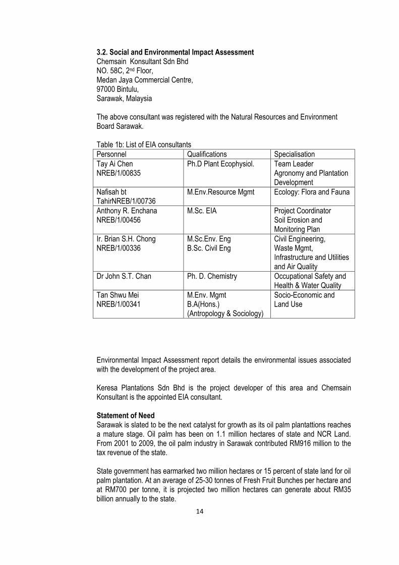
3.2. Social and Environmental Impact Assessment Chemsain Konsultant Sdn Bhd NO. 58C, 2nd Floor, Medan Jaya Commercial Centre, 97000 Bintulu, Sarawak, Malaysia
The above consultant was registered with the Natural Resources and Environment Board Sarawak. Table 1b: List of EIA consultants
Personnel Qualifications Specialisation
Tay Ai Chen NREB/1/00835
Ph.D Plant Ecophysiol. Team Leader Agronomy and Plantation Development
Nafisah bt TahirNREB/1/00736
M.Env.Resource Mgmt Ecology: Flora and Fauna
Anthony R. Enchana NREB/1/00456
M.Sc. EIA Project Coordinator Soil Erosion and Monitoring Plan
Ir. Brian S.H. Chong NREB/1/00336
M.Sc.Env. Eng B.Sc. Civil Eng
Civil Engineering, Waste Mgmt, Infrastructure and Utilities and Air Quality
Dr John S.T. Chan Ph. D. Chemistry Occupational Safety and Health & Water Quality
Tan Shwu Mei NREB/1/00341
M.Env. Mgmt B.A(Hons.) (Antropology & Sociology)
Socio-Economic and Land Use
Environmental Impact Assessment report details the environmental issues associated with the development of the project area. Keresa Plantations Sdn Bhd is the project developer of this area and Chemsain Konsultant is the appointed EIA consultant. Statement of Need Sarawak is slated to be the next catalyst for growth as its oil palm plantattions reaches a mature stage. Oil palm has been on 1.1 million hectares of state and NCR Land. From 2001 to 2009, the oil palm industry in Sarawak contributed RM916 million to the tax revenue of the state. State government has earmarked two million hectares or 15 percent of state land for oil palm plantation. At an average of 25-30 tonnes of Fresh Fruit Bunches per hectare and at RM700 per tonne, it is projected two million hectares can generate about RM35 billion annually to the state.

15
The rapid expansion of oil palm industry has brought new opportunities to investors. The project shall tap into this economic trend which is likely to persist. If carried out in a well-planned and sustainable manner, the project will be able to realize many socio-economic benefits, including the provision of job opportunities and spin-off business opportunities as well as infrastructural development to the project vicinity. Project Concept The project will be implemented by Keresa Plantations Sdn Bhd and the concept of development is such that development will only take place on NCR Land parcels of the respective landowners who have agreed to lease their land for development. The landowners are those of Rh Iba and Keresa Plantations has achieved an agreement to cultivate oil palms on NCR Land for a period of 30 years during which Keresa will have full ownership over the oil palms and harvest. After 30 years, the land will be returned to the landowners with oil palms and infrastructures thereon. In view of the development concept, the total area to be developed is subject to the participation of NCR Land owners which went through prior consultation. Project Activities Project activities can be classified into those during pre-developemnt stage, land preparation stage, oil palm nursery establishment, field planting, maintenance and harvesting of oil palms. During the pre-developement stage, the main activities are establishment of boundary and perimeter rentices, development of planting blocks, mobilization of equipment, machinery and transportation of construction materials. During land preparation stage, main activities are site clearing, disposal of solid waste particularly cleared vegetation, weeding on cleared areas and ground preparation for sowing of leguminous cover crop. By this stage, infrastructural development, i.e. establishment of roads, collection roads, base camp, drainage, bridges and culverts, utilities will have commenced. Activities associated with oil palm nursery involve securing and transferring of seedlings to polybags, watering, manuring and maintenance of nursery. During field planting, planting of legumes will take place before oil palms. Young oil palm seedlings will be transported by tractor to planting sites and subsequently planted. Maintenance of oil palms involves manuring of immature and mature palms, weeding as well as pest & disease control. Palms are normally bear fruits 28 months after planting. Ripened fruits will be harvested using specific tool and harvested fruits will be transported to the oil palm mill as soon as possible.
16
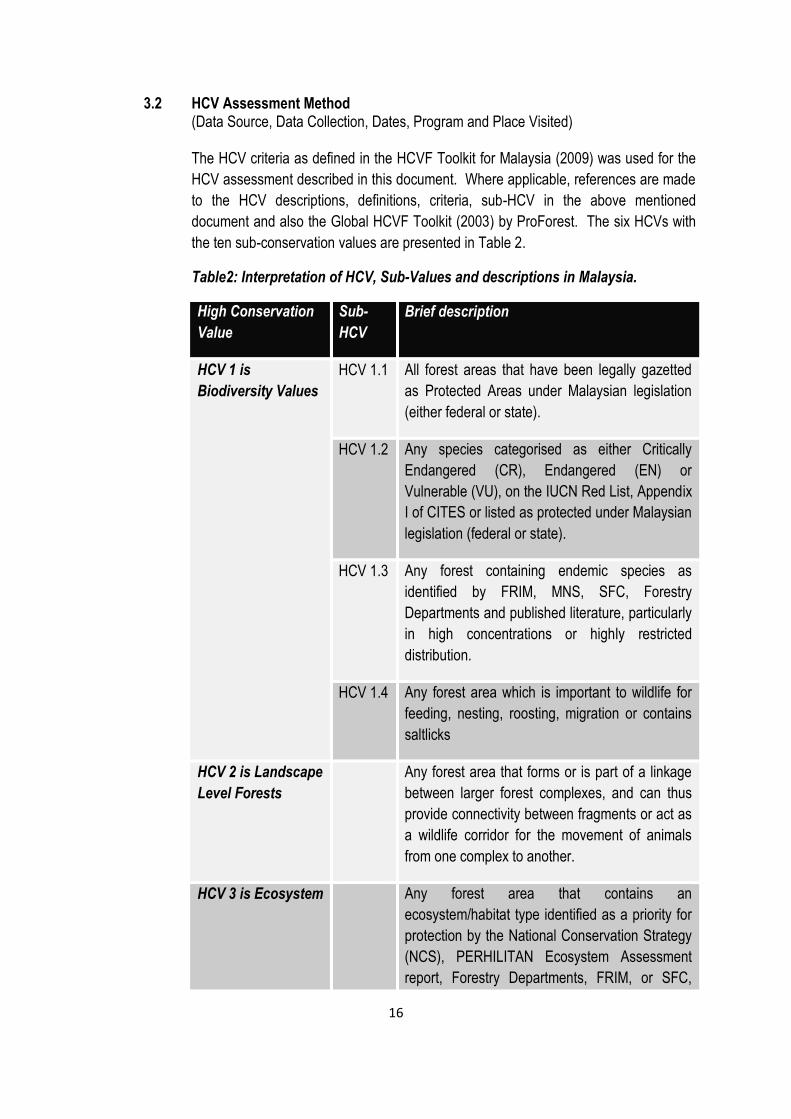
3.2 HCV Assessment Method (Data Source, Data Collection, Dates, Program and Place Visited) The HCV criteria as defined in the HCVF Toolkit for Malaysia (2009) was used for the
HCV assessment described in this document. Where applicable, references are made
to the HCV descriptions, definitions, criteria, sub-HCV in the above mentioned
document and also the Global HCVF Toolkit (2003) by ProForest. The six HCVs with
the ten sub-conservation values are presented in Table 2.
Table2: Interpretation of HCV, Sub-Values and descriptions in Malaysia.
High Conservation
Value
Sub-
HCV
Brief description
HCV 1 is
Biodiversity Values
HCV 1.1 All forest areas that have been legally gazetted
as Protected Areas under Malaysian legislation
(either federal or state).
HCV 1.2 Any species categorised as either Critically
Endangered (CR), Endangered (EN) or
Vulnerable (VU), on the IUCN Red List, Appendix
I of CITES or listed as protected under Malaysian
legislation (federal or state).
HCV 1.3 Any forest containing endemic species as
identified by FRIM, MNS, SFC, Forestry
Departments and published literature, particularly
in high concentrations or highly restricted
distribution.
HCV 1.4 Any forest area which is important to wildlife for
feeding, nesting, roosting, migration or contains
saltlicks
HCV 2 is Landscape
Level Forests
Any forest area that forms or is part of a linkage
between larger forest complexes, and can thus
provide connectivity between fragments or act as
a wildlife corridor for the movement of animals
from one complex to another.
HCV 3 is Ecosystem Any forest area that contains an
ecosystem/habitat type identified as a priority for
protection by the National Conservation Strategy
(NCS), PERHILITAN Ecosystem Assessment
report, Forestry Departments, FRIM, or SFC,
17
and/or is confirmed as such by current expert
opinion,
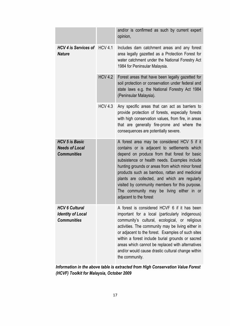
HCV 4 is Services of
Nature
HCV 4.1 Includes dam catchment areas and any forest
area legally gazetted as a Protection Forest for
water catchment under the National Forestry Act
1984 for Peninsular Malaysia.
HCV 4.2 Forest areas that have been legally gazetted for
soil protection or conservation under federal and
state laws e.g. the National Forestry Act 1984
(Peninsular Malaysia).
HCV 4.3 Any specific areas that can act as barriers to
provide protection of forests, especially forests
with high conservation values, from fire, in areas
that are generally fire-prone and where the
consequences are potentially severe.
HCV 5 is Basic
Needs of Local
Communities
A forest area may be considered HCV 5 if it
contains or is adjacent to settlements which
depend on produce from that forest for basic
subsistence or health needs. Examples include
hunting grounds or areas from which minor forest
products such as bamboo, rattan and medicinal
plants are collected, and which are regularly
visited by community members for this purpose.
The community may be living either in or
adjacent to the forest
HCV 6 Cultural
Identity of Local
Communities
A forest is considered HCVF 6 if it has been
important for a local (particularly indigenous)
community’s cultural, ecological, or religious
activities. The community may be living either in
or adjacent to the forest. Examples of such sites
within a forest include burial grounds or sacred
areas which cannot be replaced with alternatives
and/or would cause drastic cultural change within
the community.
Information in the above table is extracted from High Conservation Value Forest
(HCVF) Toolkit for Malaysia, October 2009
18
HCV assessment steps
The retrospective HCV assessment for Sungai Kubud Estate adopted a process which
followed the following steps:
1. Discussions with the management to determine the preparedness of Sungai Kubud
Estate for the retrospective HCV assessment based on the Malaysia “National
Interpretation of RSPO Principles and Criteria for Sustainable Palm Oil
Production” Final Document (including smallholder NI Approved by the RSPO
Executive Board November 2010, the baseline NI indicators and guidance as in the
approved NI dated 26 April 2008)
2. Defining the agreement between Keresa Plantations Sdn Bhd and Envirologic
Consulting together with a mutually agreed scope of work through a proposal
document and an agreed budget
3. HCV team formation, defining the project scope and roles and responsibility of the
team members
4. Compilation of secondary, available primary data, past and recent satellite imagery
5. Planning for fieldwork, time frame, work-plan and agreement on field assessment
methods for primary data collection
6. Field assessment and primary data collection, including identifying stakeholders and
in-depth stakeholder consultation
7. Data analysis and interpretation
8. Briefing to the Estate Manager and representative of the Management of Keresa
Plantations Sdn Bhd on the highlights of findings, issues identified and preliminary
conclusions
9. Preparation of Report Draft 1 including maps, management and monitoring
recommendations
10. Critical review of Report Draft 1 by Keresa Plantations Sdn Bhd
11. Revised report based on critical review by Keresa Plantations Sdn Bhd
12. Adoption of the FINAL assessment report together with the management and
monitoring plan (where and if applicable) by Sungai Kubud Estate.
The first two steps of the above process were completed by Envirologic Consulting in close
communication with the client. Steps 1 – 4 were completed during the months November -
December 2013 by Envirologic Consulting as a precursor for the retrospective HCV
assessment phase. All primary data on the biophysical aspects and social dimensions of
19
the project area landscape (Step 6) enabled the identification of stakeholders for direct
consultation in the project area and agreement on approach for primary data collection.
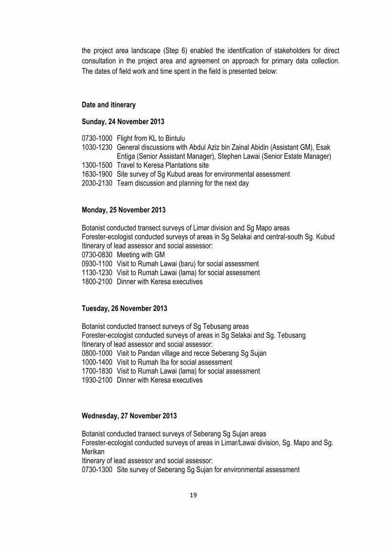
The dates of field work and time spent in the field is presented below:
Date and itinerary
Sunday, 24 November 2013
0730-1000 Flight from KL to Bintulu 1030-1230 General discussions with Abdul Aziz bin Zainal Abidin (Assistant GM), Esak
Entiga (Senior Assistant Manager), Stephen Lawai (Senior Estate Manager) 1300-1500 Travel to Keresa Plantations site 1630-1900 Site survey of Sg Kubud areas for environmental assessment 2030-2130 Team discussion and planning for the next day Monday, 25 November 2013 Botanist conducted transect surveys of Limar division and Sg Mapo areas Forester-ecologist conducted surveys of areas in Sg Selakai and central-south Sg. Kubud Itinerary of lead assessor and social assessor: 0730-0830 Meeting with GM 0930-1100 Visit to Rumah Lawai (baru) for social assessment 1130-1230 Visit to Rumah Lawai (lama) for social assessment 1800-2100 Dinner with Keresa executives Tuesday, 26 November 2013 Botanist conducted transect surveys of Sg Tebusang areas Forester-ecologist conducted surveys of areas in Sg Selakai and Sg. Tebusang Itinerary of lead assessor and social assessor: 0800-1000 Visit to Pandan village and recce Seberang Sg Sujan 1000-1400 Visit to Rumah Iba for social assessment 1700-1830 Visit to Rumah Lawai (lama) for social assessment 1930-2100 Dinner with Keresa executives
Wednesday, 27 November 2013 Botanist conducted transect surveys of Seberang Sg Sujan areas Forester-ecologist conducted surveys of areas in Limar/Lawai division, Sg. Mapo and Sg. Merikan Itinerary of lead assessor and social assessor: 0730-1300 Site survey of Seberang Sg Sujan for environmental assessment
20
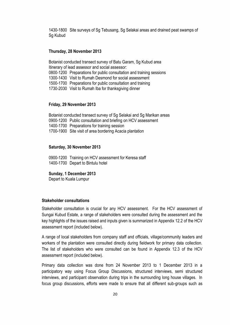
1430-1800 Site surveys of Sg Tebusang, Sg Selakai areas and drained peat swamps of Sg Kubud
Thursday, 28 November 2013 Botanist conducted transect survey of Batu Garam, Sg Kubud area Itinerary of lead assessor and social assessor: 0800-1200 Preparations for public consultation and training sessions 1300-1430 Visit to Rumah Desmond for social assessment 1500-1700 Preparations for public consultation and training 1730-2030 Visit to Rumah Iba for thanksgiving dinner Friday, 29 November 2013 Botanist conducted transect survey of Sg Selakai and Sg Marikan areas 0900-1200 Public consultation and briefing on HCV assessment 1400-1700 Preparations for training session 1700-1900 Site visit of area bordering Acacia plantation Saturday, 30 November 2013 0900-1200 Training on HCV assessment for Keresa staff 1400-1700 Depart to Bintulu hotel Sunday, 1 December 2013 Depart to Kuala Lumpur
Stakeholder consultations
Stakeholder consultation is crucial for any HCV assessment. For the HCV assessment of
Sungai Kubud Estate, a range of stakeholders were consulted during the assessment and the
key highlights of the issues raised and inputs given is summarized in Appendix 12.2 of the HCV
assessment report (included below).
A range of local stakeholders from company staff and officials, village/community leaders and
workers of the plantation were consulted directly during fieldwork for primary data collection.
The list of stakeholders who were consulted can be found in Appendix 12.3 of the HCV
assessment report (included below).
Primary data collection was done from 24 November 2013 to 1 December 2013 in a
participatory way using Focus Group Discussions, structured interviews, semi structured
interviews, and participant observation during trips in the surrounding long house villages. In
focus group discussions, efforts were made to ensure that all different sub-groups such as
21
Village Head, Deputy Village Head, Women Representative, youth and old folks were
interviewed.
The selection of the villages was done based on overlapping or nearby (within 5 km) radius of
Sungai Kubud Estate, using a map of the project area. Direct stakeholders consulted during
assessment included the Village Head, and Deputy Village Head and other representatives
such as religious leaders, local leaders, etc.
Flora and fauna surveys
Rapid assessment of mammals, reptiles and birds aimed to identify the features of these
animal communities relevant to HCV 1.2, HCV 1.3 and HCV 1.4 were carried out. Survey
methods included direct (visual) or indirect (print, call, scat for mammals and call for birds)
observations during the day and late afternoon/evening field work, and interviews with
company staff, labourers and villagers. These methods were combined to maximise
completeness of animal species listing in the short time available (HCV 1.2 and HCV 1.3). In
addition, habitat quality assessment was carried out to find areas that are temporarily used by
animals (birds or bats) such as a breeding or nesting ground area (HCV 1.4).
The field surveys were carried out in the oil palm estates and the existing forested areas,
namely logged over Mixed Dipterocarp Forests (MDF), Kerangas Forests and Peat Swamp
Forests. Some of the peat swamp forests are found in the Selakai region in the west and some
in Merikan region in the north of the project site. The Kerangas forests are located in Limar
region and the lowland MDF mostly in the central regions and occur in sporadic location. All
these forests have been logged over different periods of time since 1975, based on information
provided by the locals and village elders. In addition, field surveys were carried out in some of
the areas being claimed ownership as shifting cultivation areas by the local communities from
the longhouses.
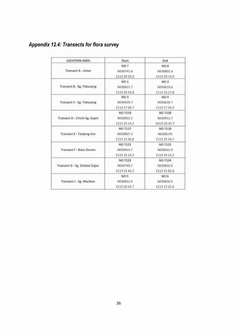
A total of 8 transects were carried out for the flora survey to capture the diversity, distribution
and abundance of the plant community. The details of the eight transects used for the flora
survey are shown in Appendix 12.4 (included below).
In addition, field surveys were carried out in remaining secondary forests and riparian areas
adjacent to the land area of Sungai Kubud Estate to maximise completeness of animals
species listed under HCV 1.2 and 1.3 as well as the list of areas temporarily used by animals
(HCV 1.4).
4. Summary of Assessment Findings
4.1 Summary from SEIA Assessment Findings
Summary of key findings in respect of socio-economic impacts to country, region and local
communities
22
Positive Impact:
- Positive attitude and perception from the community and looking forward for the plantation income.
- Increase in job opportunities for the surrounding local communities because of the new development operation.
- Increase in community income due to the employment and infrastructure service provided due to the new development operations.
- Opportunity for the community to involve and manage their own plantation when the lease tenure expires.
- Opportunity for community to involve in small scale business ventures and transport.
Negative Impact
- Land developed for the oil palm cultivation for the community will restrict planting of other crop.
- Social conflict may arise among the community who holds the land and without land. - Increasing land transportation and traffic will increase potential risk to the safety of the
community. - Air and water pollution may occurs and increase the potential risk of the communities’
health. Environmental Management Plan An EMP is recommended to ensure that the Environmental Impacts predicted are properly monitored and managed. This plan should be reviewed regularly to include changes or other impacts that may be identified in the course of the project. A comprehensive EM{P report shall be outlined subsequent to the approval of EIA by NREB. Generally, EMP identifies the following:- a. Policy and objectives of EMP b. Administrative set-up responsible for environmental management including structure and manpower requirements and responsibilities of various key personnel. c. Legislative requirements that need to be complied. d. Project Plan e. Environmental Monitoring program. f. Actions required and reporting sequence.
4.2 Summary from HCV Assessment Findings
HCV assessment of Sg. Kubud Estate, a new development area of Keresa Plantations Sdn Bhd was conducted by Envirologic Consulting. The assessment was carried out from 24 November 2013 to 1 December 2013 by a team leader Dr. Sanath Kumaran with of five ecological and social experts focussing on all six HCVs. Envirologic Consulting is an approved High Conservation Value (HCV) assessor of the Roundtable on Sustainable Palm Oil (RSPO). The assessment included satellite imaginary analysis, extensive field surveys, and public consultations with the communities living in the project area. The HCV assessment report included recommendations for the management and improvement of HCV found within the project area.
23
The assessment revealed that HCV 1.2 is present in the form of several flora and fauna
species and the presence of Bornean Yellow Muntjac qualifies it as HCV1.3 as an IUCN
Endemic species. The HCV 1.4 is potentially present as the wetlands (rivers and streams) are
potentially used by migratory birds. HCV3 is present in the form of two priority habitats for
Sarawak, viz. Peat swamp forests and Heath forests (Kerangas). For erosion control, the
presences of fragmented riparian vegetation which are not legally gazetted were noted along
the major rivers draining the project area and flowing through the plantation area. These
forests are significant in the long term to enhance wildlife corridors and minimize stream bank
erosions and sediment load of the rivers (potential HCV4.2). Areas that are prone to fires
during prolonged drought are the drained peat swamps and Acacia mangium plantations of
Grand Perfect Sdn Bhd, bordering the project area in the south west (potential HCV4.3).
HCV 2, HCV 5 and HCV 6 were not identified although a graveyard was noted by an individual
from Rh. Iba longhouse as a Penan graveyard, which does not have any significant historical
and cultural value for the locals.
Table 3: Identification and Analysis of HCVs Presence in the area of Sg. Kubud Estate.
HCV Sub-HCV Present Potentially
Present Absent
HCV 1
Biodiversity
Values
1.1 All forest areas
that have been legally
gazetted as Protected
Areas under Malaysian
legislation (either
federal or state).
Not identified
1.2 Any species categorised as either Critically Endangered (CR), Endangered (EN) or Vulnerable (VU), on the IUCN Red List, Appendix I of CITES or listed as protected under Malaysian legislation (federal or state).
Presence of the
following species
were noted:
Sun bear
Sambar deer
Asian Brown
Tortoise
Light Red
Meranti
1.3 Any forest
containing endemic
species as identified
Presence of the
Bornean Yellow
24
HCV Sub-HCV Present Potentially
Present Absent
by FRIM, MNS, SFC,
Forestry Departments
and published
literature, particularly
in high concentrations
or highly restricted
distribution.
Muntjac noted
1.4 Any forest area which is important to wildlife for feeding, nesting, roosting, migration or contains saltlicks
Presence of
migratory birds
HCV 2
Landscape Level
Forests
Not identified as
the plantation is
located
surrounded by
industrial tree
plantation, oil
palm plantations,
logged over
forest areas
HCV 3
Ecosystem
Any forest area that
contains an
ecosystem/habitat type
identified as a priority
for protection
Peat swamp
forests
and
Heath forests
(Kerangas)
HCV 4 Services
of Nature
4.1 Dam catchment areas and any forest area legally gazetted as a Protection Forest for water catchment under the National Forestry Act 1984
Not identified
4.2 Forest areas that have been legally gazetted for soil
All buffer zones
along rivers.
25
HCV Sub-HCV Present Potentially
Present Absent
protection or conservation under federal and state laws
Vegetation
riparian buffer
reserves along
rivers are intact
with varying
width and quality
along the oil
palm blocks.
4.3 Any specific areas that can act as barriers to provide protection of forests, especially forests with high conservation values, from fire
Areas that are
prone to fires,
e.g. peat
swamps and oil
palm blocks
bordering to
Acacia mangium
plantations
HCV 5 Basic
needs of local
communities.
Rh. Iba
Rh. Lawai
Rh. Majang
Rh. Desmond
The longhouse
communities are
not forest
dependent for
basic
subsistence or
health needs
HCV 6 Cultural
identity of local
communities
Rh. Iba
Rh. Lawai
Rh. Majang
Rh. Desmond
The longhouse
communities are
not use the
forest for their
cultural, or
religious
activities
26
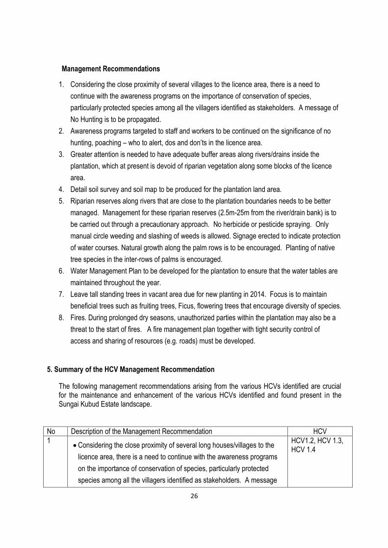
Management Recommendations
1. Considering the close proximity of several villages to the licence area, there is a need to
continue with the awareness programs on the importance of conservation of species,
particularly protected species among all the villagers identified as stakeholders. A message of
No Hunting is to be propagated.
2. Awareness programs targeted to staff and workers to be continued on the significance of no
hunting, poaching – who to alert, dos and don’ts in the licence area.
3. Greater attention is needed to have adequate buffer areas along rivers/drains inside the
plantation, which at present is devoid of riparian vegetation along some blocks of the licence
area.
4. Detail soil survey and soil map to be produced for the plantation land area.
5. Riparian reserves along rivers that are close to the plantation boundaries needs to be better
managed. Management for these riparian reserves (2.5m-25m from the river/drain bank) is to
be carried out through a precautionary approach. No herbicide or pesticide spraying. Only
manual circle weeding and slashing of weeds is allowed. Signage erected to indicate protection
of water courses. Natural growth along the palm rows is to be encouraged. Planting of native
tree species in the inter-rows of palms is encouraged.
6. Water Management Plan to be developed for the plantation to ensure that the water tables are
maintained throughout the year.
7. Leave tall standing trees in vacant area due for new planting in 2014. Focus is to maintain
beneficial trees such as fruiting trees, Ficus, flowering trees that encourage diversity of species.
8. Fires. During prolonged dry seasons, unauthorized parties within the plantation may also be a
threat to the start of fires. A fire management plan together with tight security control of
access and sharing of resources (e.g. roads) must be developed.
5. Summary of the HCV Management Recommendation
The following management recommendations arising from the various HCVs identified are crucial for the maintenance and enhancement of the various HCVs identified and found present in the Sungai Kubud Estate landscape.
No Description of the Management Recommendation HCV
1 Considering the close proximity of several long houses/villages to the
licence area, there is a need to continue with the awareness programs
on the importance of conservation of species, particularly protected
species among all the villagers identified as stakeholders. A message
HCV1.2, HCV 1.3, HCV 1.4
27
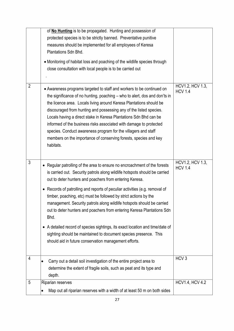
of No Hunting is to be propagated. Hunting and possession of
protected species is to be strictly banned. Preventative punitive
measures should be implemented for all employees of Keresa
Plantations Sdn Bhd.
Monitoring of habitat loss and poaching of the wildlife species through
close consultation with local people is to be carried out
.
2 Awareness programs targeted to staff and workers to be continued on
the significance of no hunting, poaching – who to alert, dos and don’ts in
the licence area. Locals living around Keresa Plantations should be
discouraged from hunting and possessing any of the listed species.
Locals having a direct stake in Keresa Plantations Sdn Bhd can be
informed of the business risks associated with damage to protected
species. Conduct awareness program for the villagers and staff
members on the importance of conserving forests, species and key
habitats.
HCV1.2, HCV 1.3, HCV 1.4
3 Regular patrolling of the area to ensure no encroachment of the forests
is carried out. Security patrols along wildlife hotspots should be carried
out to deter hunters and poachers from entering Keresa.
Records of patrolling and reports of peculiar activities (e.g. removal of
timber, poaching, etc) must be followed by strict actions by the
management. Security patrols along wildlife hotspots should be carried
out to deter hunters and poachers from entering Keresa Plantations Sdn
Bhd.
A detailed record of species sightings, its exact location and time/date of
sighting should be maintained to document species presence. This
should aid in future conservation management efforts.
HCV1.2, HCV 1.3, HCV 1.4
4 Carry out a detail soil investigation of the entire project area to
determine the extent of fragile soils, such as peat and its type and
depth.
HCV 3
5 Riparian reserves
Map out all riparian reserves with a width of at least 50 m on both sides
HCV1.4, HCV 4.2
28
of the river and mark it permanently on the ground with visible pegs (at
20 m intervals) along the river/stream banks. The total hectarage of the
riparian reserve for the entire project area is to be maintained and
enhanced through systematic enrichment planting
Riparian reserves along rivers that are close to the plantation
boundaries needs to be better managed. These riparian reserve areas
have to be rehabilitated to its original stand of vegetation.
Management for these riparian reserves is to be carried out through a
precautionary approach. No herbicide or pesticide spraying. Only
manual circle weeding and slashing of weeds is allowed. Signage
erected to indicate protection of water courses. Natural growth along
the palm rows is to be encouraged.
The planted oil palm stand in the riparian reserves be removed and
replaced with suitable tree species originally found along the rivers.
Rehabilitation of the area with mixed species is strongly recommended
(see list of species in text in HCV 4.2).
No further planting of oil palm in the forest and wildlife corridors along
riparian areas and those bordering to forested land areas
Maintenance of adequate (at least 50m) of riparian buffers along
permanent flowing streams
All riparian zones to be re-vegetated with suitable native species, with
existing trees left intact. The width of the riparian zone will adhere to the
recommended standard of 50-100m for wildlife purposes. Signage
should also be erected to promote awareness of protecting these areas.
In the process of conserving the riparian buffers, management options
should include no slashing of existing vegetation, taking a precautionary
approach to application of agrochemicals (fertilizers, herbicides,
pesticides) in the riparian buffer zones and no alteration/damming of the
river channel.
A wildlife corridor at least 50-100m wide on both side of the river should
be maintained along the Sg Mapo area where frequent wildlife
movements have been sighted. The exact location of this corridor
needs to be determined, but is likely to be along Sg Mapo. Signage to
urge vehicle slowdown and caution should be erected.
29
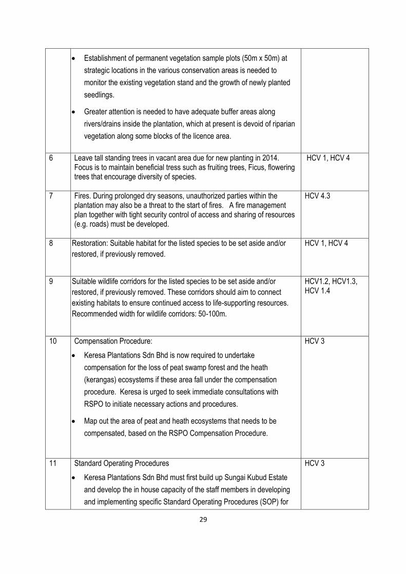
Establishment of permanent vegetation sample plots (50m x 50m) at
strategic locations in the various conservation areas is needed to
monitor the existing vegetation stand and the growth of newly planted
seedlings.
Greater attention is needed to have adequate buffer areas along
rivers/drains inside the plantation, which at present is devoid of riparian
vegetation along some blocks of the licence area.
6 Leave tall standing trees in vacant area due for new planting in 2014. Focus is to maintain beneficial tress such as fruiting trees, Ficus, flowering trees that encourage diversity of species.
HCV 1, HCV 4
7 Fires. During prolonged dry seasons, unauthorized parties within the plantation may also be a threat to the start of fires. A fire management plan together with tight security control of access and sharing of resources (e.g. roads) must be developed.
HCV 4.3
8 Restoration: Suitable habitat for the listed species to be set aside and/or
restored, if previously removed.
HCV 1, HCV 4
9 Suitable wildlife corridors for the listed species to be set aside and/or
restored, if previously removed. These corridors should aim to connect
existing habitats to ensure continued access to life-supporting resources.
Recommended width for wildlife corridors: 50-100m.
HCV1.2, HCV1.3, HCV 1.4
10 Compensation Procedure:
Keresa Plantations Sdn Bhd is now required to undertake
compensation for the loss of peat swamp forest and the heath
(kerangas) ecosystems if these area fall under the compensation
procedure. Keresa is urged to seek immediate consultations with
RSPO to initiate necessary actions and procedures.
Map out the area of peat and heath ecosystems that needs to be
compensated, based on the RSPO Compensation Procedure.
HCV 3
11 Standard Operating Procedures
Keresa Plantations Sdn Bhd must first build up Sungai Kubud Estate
and develop the in house capacity of the staff members in developing
and implementing specific Standard Operating Procedures (SOP) for
HCV 3

30
peat management, fire hazards and water management.
Develop a fire hazard response plan, including erecting a fire watch
tower
Develop a Water Management Plan for the peat and low lying areas to
ensure that the water tables are maintained throughout the year.
Develop specific SOP for conservation efforts such as maintenance
and enhancement of riparian reserves, wildlife monitoring, tackling of
potential threats such as illegal hunting, poaching.
12 Hydrology of peat lands and low lying areas
The drained peat swamp areas at the Sg Kubud area will now need to
be managed against fire by implementing a suitable water table
management plan. This should avoid draining the water table to
excessively low levels that promote complete drying out of the peat
soils.
A detailed hydrological study is to be conducted to ascertain the nature
and extent of the water table management intervention required.
General RSPO guidelines for 4.3.4 for minimization of subsidence of
peat soils recommends maintaining an average water table depth of
60cm below ground surface as measured in water collection drains,
through a network of appropriate water control structures e.g. weirs,
sandbags, etc, in fields, and water-gates at the discharge points of
main drains (Criteria 4.4 and 7.4).
The remnant forest in the “Lawai Division” bordering the Acacia
mangium plantation of Grand Perfect should be left to act as a natural
fire barrier. The recommended width is 50-100m to also serve as a
wildlife corridor
HCV 3
31
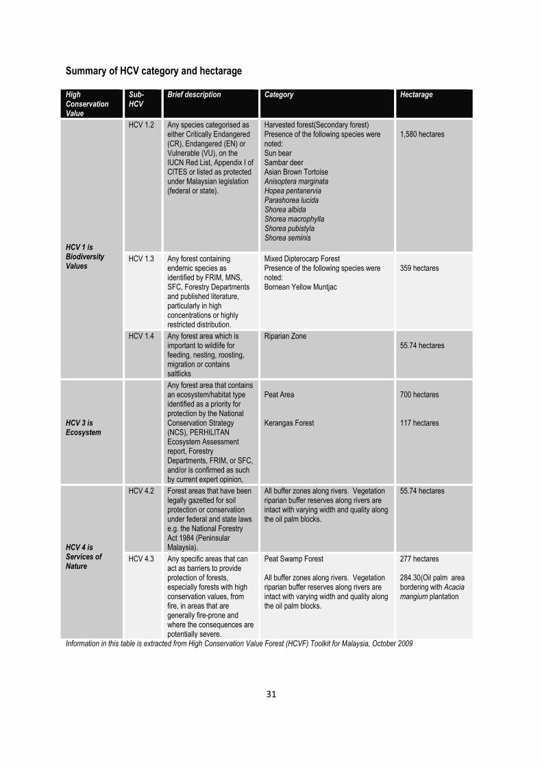
Summary of HCV category and hectarage High Conservation Value
Sub-HCV
Brief description Category Hectarage
HCV 1 is Biodiversity Values
HCV 1.2 Any species categorised as either Critically Endangered (CR), Endangered (EN) or Vulnerable (VU), on the IUCN Red List, Appendix I of CITES or listed as protected under Malaysian legislation (federal or state).
Harvested forest(Secondary forest) Presence of the following species were noted: Sun bear Sambar deer Asian Brown Tortoise Anisoptera marginata Hopea pentanervia Parashorea lucida Shorea albida Shorea macrophylla Shorea pubistyla Shorea seminis
1,580 hectares
HCV 1.3 Any forest containing endemic species as identified by FRIM, MNS, SFC, Forestry Departments and published literature, particularly in high concentrations or highly restricted distribution.
Mixed Dipterocarp Forest Presence of the following species were noted: Bornean Yellow Muntjac
359 hectares
HCV 1.4 Any forest area which is important to wildlife for feeding, nesting, roosting, migration or contains saltlicks
Riparian Zone 55.74 hectares
HCV 3 is Ecosystem
Any forest area that contains an ecosystem/habitat type identified as a priority for protection by the National Conservation Strategy (NCS), PERHILITAN Ecosystem Assessment report, Forestry Departments, FRIM, or SFC, and/or is confirmed as such by current expert opinion,
Peat Area Kerangas Forest
700 hectares 117 hectares
HCV 4 is Services of Nature
HCV 4.2 Forest areas that have been legally gazetted for soil protection or conservation under federal and state laws e.g. the National Forestry Act 1984 (Peninsular Malaysia).
All buffer zones along rivers. Vegetation riparian buffer reserves along rivers are intact with varying width and quality along the oil palm blocks.
55.74 hectares
HCV 4.3 Any specific areas that can act as barriers to provide protection of forests, especially forests with high conservation values, from fire, in areas that are generally fire-prone and where the consequences are potentially severe.
Peat Swamp Forest All buffer zones along rivers. Vegetation riparian buffer reserves along rivers are intact with varying width and quality along the oil palm blocks.
277 hectares 284.30(Oil palm area bordering with Acacia mangium plantation
Information in this table is extracted from High Conservation Value Forest (HCVF) Toolkit for Malaysia, October 2009
32
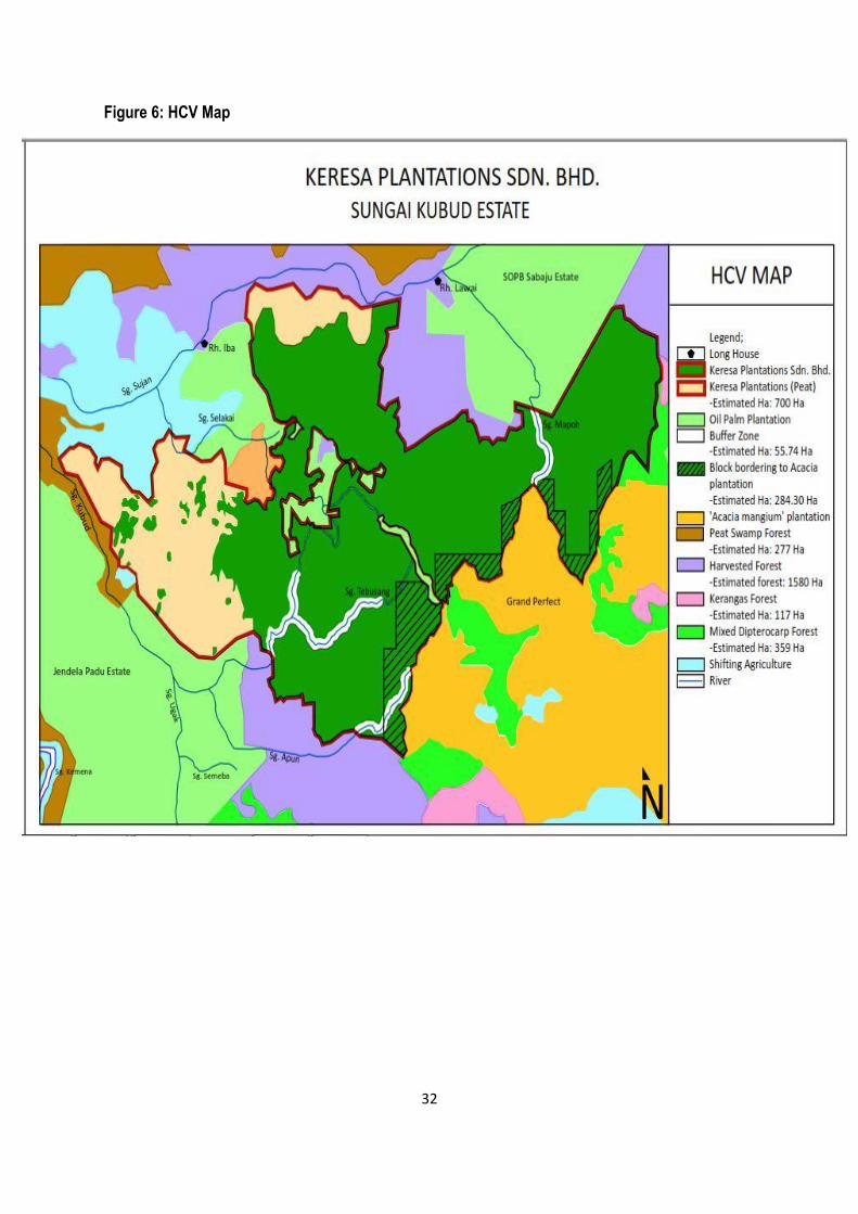
Figure 6: HCV Map
33
34
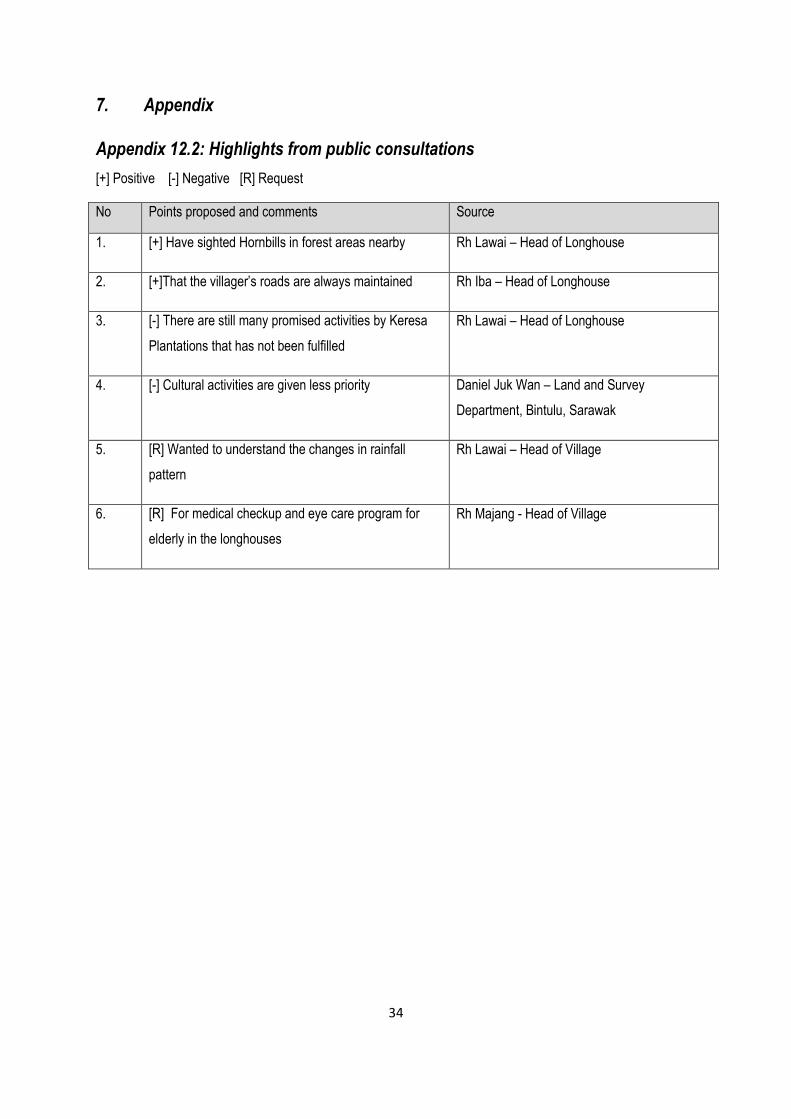
7. Appendix
Appendix 12.2: Highlights from public consultations
[+] Positive [-] Negative [R] Request
No Points proposed and comments Source
1. [+] Have sighted Hornbills in forest areas nearby Rh Lawai – Head of Longhouse
2. [+]That the villager’s roads are always maintained Rh Iba – Head of Longhouse
3. [-] There are still many promised activities by Keresa
Plantations that has not been fulfilled
Rh Lawai – Head of Longhouse
4. [-] Cultural activities are given less priority Daniel Juk Wan – Land and Survey
Department, Bintulu, Sarawak
5. [R] Wanted to understand the changes in rainfall
pattern
Rh Lawai – Head of Village
6. [R] For medical checkup and eye care program for
elderly in the longhouses
Rh Majang - Head of Village
35
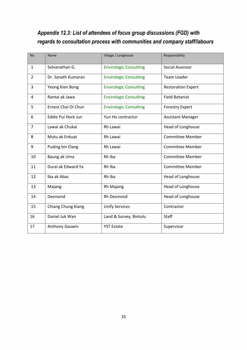
Appendix 12.3: List of attendees of focus group discussions (FGD) with
regards to consultation process with communities and company staff/labours
No Name Village / Longhouse Responsibility
1 Selvanathan G. Envirologic Consulting Social Assessor
2 Dr. Sanath Kumaran Envirologic Consulting Team Leader
3 Yeong Kien Bong Envirologic Consulting Restoration Expert
4 Rantai ak Jawa Envirologic Consulting Field Botanist
5 Ernest Chai Oi Chun Envirologic Consulting Forestry Expert
6 Eddie Pui Hock Jun Yun Ho contractor Assistant Manager
7 Lawai ak Chukai Rh Lawai Head of Longhouse
8 Mutu ak Enkuat Rh Lawai Committee Member
9 Puding bin Elang Rh Lawai Committee Member
10 Baung ak Uma Rh Iba Committee Member
11 Durai ak Edward Ya Rh Iba Committee Member
12 Iba ak Abas Rh Iba Head of Longhouse
13 Majang Rh Majang Head of Longhouse
14 Desmond Rh Desmond Head of Longhouse
15 Chiang Chung Kiang Unify Services Contractor
16 Daniel Juk Wan Land & Survey, Bintulu Staff
17 Anthony Gauwin YST Estate Supervisor
36
Appendix 12.4: Transects for flora survey