Rother District Local Plan · List of Inset Maps Inset Map No. Town/Village 1 Bexhill-on-Sea 1a...
129
Rother District Local Plan Adopted July 2006 Rother District Council Town Hall Bexhill-on-Sea East Sussex TN39 3JX Tel: 01424 787878 www.rother.gov.uk Cover photographs courtesy of Rother District Council (Except bottom photograph courtesy of Janina Holubecki/High Weald AONB unit)
-
Upload
nguyenhanh -
Category
Documents
-
view
215 -
download
0
Transcript of Rother District Local Plan · List of Inset Maps Inset Map No. Town/Village 1 Bexhill-on-Sea 1a...

Rother District Local Plan
Adopted July 2006 Rother District Council Town Hall Bexhill-on-Sea East Sussex TN39 3JX Tel: 01424 787878 www.rother.gov.uk Cover photographs courtesy of Rother District Council (Except bottom photograph courtesy of Janina Holubecki/High Weald AONB unit)
CONTENTS Page no.
1. INTRODUCTION 1 Purpose of the Local Plan 1 Context for the Local Plan 1 Scope and structure 2 Use of the Plan 3
2. CONTEXT AND VISION 4 Main issues 4 Relationship to the community strategy 6 Corporate plan and strategies 7 Vision and aims 7
3. THE PLANNING POLICY FRAMEWORK FOR ROTHER DISTRICT 9 Planning policy framework 9 National planning policies 10 Regional planning guidance 12 The Structure Plan 12
4. DEVELOPMENT STRATEGY 14 Introduction 14 Development principles 14 Housing land requirements 16 Business land requirements 17 Towards a spatial strategy 19 Development boundaries 22 Strategic gaps 23 Summary of housing land provisions 24 Managing housing land release 27 Summary of employment land provisions 28
5. GENERAL DEVELOPMENT CONSIDERATIONS 30 Protecting amenities 31 Design and respecting local character 32 Ensuring availability of infrastructure and services 34 Making best use of environmental resources 36
6. HOUSING DEVELOPMENTS 37
Affordable housing 37 Housing mix 40 Layout and design 41 Residential mobile homes 42 Sites for gypsies and travelling showpeople 43 Retention of housing stock 43 Extensions to dwellings 44 Extensions to residential curtilages 45 Dwellings in the countryside 45
7. COMMUNITY FACILITIES 49 New and improved community facilities 50 Recreation standards and open space facilities 50
Equestrian development 50 Renewable energy 51 Public art 53

8. TRANSPORT DEVELOPMENTS 54 Introduction 54 Transport infrastructure 54 Promoting sustainable transport 56 Car and cycle parking standards 57
9. EMPLOYMENT DEVELOPMENTS 60 New business development, including through mixed uses 60 Employment use of buildings in the countryside 61 Marley Lane – Land at Rutherfords Business Park 62 Marley Lane – Land at D.B. Earthmoving 62 Businesses in residential areas 64 Tourism 64 Shopping 67
10. BEXHILL 70
Context 70 Planning strategy 71 North-east Bexhill 73 Town Centre 78 Development boundary 79 Former Galley Hill Depot, Ashdown Road 80 High School site and Drill Halls, Down Road 81 Land west of Bexhill Cemetery 81
11. BATTLE 82 Context 82 Planning strategy 83 Land at Blackfriars 84 Land north of North Trade Road 85 Town Centre 86
12. RYE AND RYE HARBOUR 87 Context 87 Planning Strategy for Rye and Rye Harbour 88 Land adjacent to Rock Channel 89 Former Thomas Peacocke Lower School and adjacent land 91 Land north of Udimore Road 92 Town centre 92 Rye Harbour Road Employment Area 93 Land adjacent Stonework Cottages, Harbour Road, Rye Harbour 94
13. VILLAGES 95 Burwash 96 Etchingham 97 Fairlight Cove 98 Flimwell 99 Northiam 101 Robertsbridge 101 Westfield 104 Winchelsea Beach 106
14. HASTINGS FRINGES 107 Land east of Burgess Road 107 Land off Woodlands Way 108

List of Inset Maps
Inset Map No.
Town/Village
1 Bexhill-on-Sea 1a North-east Bexhill 1b High School and Drill Halls, Down Road, Bexhill 1c Former Galley Hill Depot. Ashdown Road, Bexhill 1d Bexhill Town Centre 1e Bexhill Cemetery 1f Sidley 1g Little Common 2 Battle 2a Battle Town Centre 3 Rye and Rye Harbour 3a Rye Town Centre 4 Bachelor’s Bump 5 Beckley 6 Brede and Cackle Street 7 Broad Oak 8 Burwash 9 Burwash Common and Burwash Weald 10 Camber 11 Catsfield 12 Crowhurst 13 Etchingham 14 Fairlight Cove 15 Flimwell 16 Four Oaks 17 Guestling Green 18 Hastings Fringe – Ivyhouse Lane/Austen Way 19 Hastings Fringe – Parkwood Road/Denehurst Gardens 20 Hurst Green 21 Icklesham 22 Iden 23 Marley Lane Employment Sites 24 Netherfield 25 Normans Bay 26 Northiam 27 Peasmarsh 28 Pett and Friars Hill 29 Pett Level 30 Robertsbridge 31 Sedlescombe 32 Staplecross 33 Stonegate 34 Three Oaks 35 Ticehurst 36 Westfield 37 Westfield Lane 38 Winchelsea 39 Winchelsea Beach

List of Tables
Table No. Title Page
1 Sources of Housing Supply 17 2 Progress towards Structure Plan office, industrial and
warehousing floorspace requirements in Rother and Hastings 18
3 Summary of Housing allocations 25 4 Summary of Housing Land Supply 26 5 Longer-term housing supply 27 6 Summary of employment allocations 29 7 Vacant sites without planning permission, Harbour Road, Rye 93
List of Figures
Figure No. Title Page
1 Local Plan Process and Timetable 2 2 Population Structure of Rother District compared to the UK
average 4
3 Main Settlements And Transport Network 5 4 Area of Outstanding Natural Beauty and Ancient
Woodland 6
5 Hierarchy of planning policy documents 10 6 Draft Hastings and Bexhill Masterplan 72 List of Appendices Appendix no.
Title
1 Availability of planning policy documents 2 Key Structure Plan and Waste Local Plan policies 3 National Playing Fields Association
The Six Acre Standard Minimum Standards for Outdoor Playing Space
4 Large Residential Site Commitments as at 1st April 2004

Index of Policies
Policy No. Title Page Section 4 - Development Strategy Policy DS1 Development principles 15 Policy DS2 Overall spatial strategy 21 Policy DS3 Proposals within development boundaries 23 Policy DS4 Proposals outside development boundaries 23 Policy DS5 Strategic gaps 24 Policy DS6 Managing housing land release 28 Section 5 - General Development Considerations Policy GD1 General development criteria 30 Policy GD2 Availability of infrastructure and services 35 Section 6 - Housing Developments Policy HG1 Affordable housing 39 Policy HG2 Affordable housing outside development boundaries 39 Policy HG3 Housing mix 40 Policy HG4 Principles of sustainable residential environments 41 Policy HG5 Residential mobile homes 42 Policy HG6 Sites for gypsies and travelling showpeople 43 Policy HG7 Retention of existing housing stock 44 Policy HG8 Extensions and alterations to existing dwellings 44 Policy HG9 Extensions to residential curtilages 45 Policy HG10 New dwellings in the countryside 45 Policy HG11 Residential re-use and adaptation of buildings 46 Section 7 - Community Facilities Policy CF1 New community facilities 46 Policy CF2 Safeguarding of recreational/leisure facilities 46 Policy CF3 Proposals for sports and recreation facilities 47 Policy CF4 Provision of play areas 47 Policy CF5 Equestrian development 48 Policy CF6 Provision of public art 49 Section 8 - Transport Developments Policy TR1 Bexhill-Hastings link road area of search 55 Policy TR2 Improvements to sustainable transport 57 Policy TR3 Provision of parking facilities 58

Section 9 - Employment Developments Policy EM1 New business development including through mixed uses 60 Policy EM2 Retention of employment sites and buildings 61 Policy EM3 Employment, including tourism, use of buildings in the countryside 61 Policy EM4 Marley Lane – land at Rutherfords Business Park 62 Policy EM5 Marley Lane – land adjacent to DB Earthmoving 63 Policy EM6 Businesses in residential areas 64 Policy EM7 New and extended tourist attractions and visitor facilities 64 Policy EM8 Extension of steam railway from Bodiam to Robertsbridge 65 Policy EM9 Tourist accommodation 65 Policy EM10 Chalet, caravan and camping accommodation 66 Policy EM11 Occupation of holiday chalets, static and touring caravans 67 Policy EM12 Winter storage of caravans 67 Policy EM13 Shopping and related commercial development in town/district centres 68 Policy EM14 Retail development outside town and district centres 69 Policy EM15 Retail development in within town and village development boundaries 69 Section 10 - Bexhill Policy BX1 Planning strategy for Bexhill 71 Policy BX2 Land north of Pebsham 74 Policy BX3 Land north of Sidley 76 Policy BX4 Countryside Park 77 Policy BX5 Town centre shopping area 78 Policy BX6 Town centre development area 79 Policy BX7 Town centre office areas 79 Policy BX8 Former Galley Hill depot, Ashdown Road 80 Policy BX9 High School and Drill Halls, Down Road 81 Policy BX10 Cemetery extension 81 Section 11 - Battle Policy BT1 Planning strategy for Battle 83 Policy BT2 Land at Blackfriars 84 Policy BT3 Land at North Trade Road 85 Section 12 - Rye and Rye Harbour Policy RY1 Planning strategy for Rye 88 Policy RY2 Planning strategy for Rye Harbour 88 Policy RY3 Land adjacent to Rock Channel 89 Policy RY4 Former Thomas Peacocke Lower School 91 Policy RY5 Land north of Udimore Road 92 Policy RY6 Town centre 92 Policy RY7 Rye Harbour Road Employment Area 93 Policy RY8 Land adjacent to Stonework Cottages, Rye Harbour 94

Section 13 - Villages Policy VL1 Land South of Strand Meadow, Burwash 96 Policy VL2 Land west of Etchingham 97 Policy VL3 Land adjacent to Fairlight Gardens, Fairlight Cove 98 Policy VL4 Land at Corner Farm, Flimwell 99 Policy VL5 Land west of Old Wardsdown 100 Policy VL6 Land east of the Village Hall at Northiam 101 Policy VL7 Land at Grove Farm, Robertsbridge 101 Policy VL8 Land adjacent to Culverwells, Robertsbridge 103 Policy VL9 Land off Moor Lane, Westfield 104 Policy VL10 Extension to Wheel Farm Business Park 105 Policy VL11 Land at Westfield Down, Westfield 105 Policy VL12 Victoria Way and land south of Harbour Farm, Winchelsea Beach 106 Section 14 - Hastings Fringes Policy HF1 Land off Burgess Road 107 Policy HF2 Land off Woodlands Way 108

Adopted Rother District Local Plan (July 2006) 1
1. I N T R O D U C T I O N
Purpose of the Local Plan 1.1 This Local Plan sets out the vision and strategy for land use and development in Rother
District. It includes specific planning policies and proposals that will be applied to manage development and change up to 2011.
1.2 The Local Plan has been prepared by Rother District Council1 as the Local Planning
Authority. It is intended that the adoption of these planning policies, and their sensitive application by all parties involved in the development process, will make a significant contribution to the quality of life of people living and working in Rother District.
1.3 The Council has a duty to prepare this Local Plan. In fulfilling this, it is also obliged to meet
certain housing and other development requirements placed on the District. The Local Plan sets out how these, as well as the reasonable development needs and aspirations of local people, will be accommodated in the most sustainable way.
1.4 The overall scale of development to be accommodated, and the broad policy framework for
distributing it has already been determined by the East Sussex and Brighton and Hove Structure Plan 1991-20112. A key function of this Local Plan is to translate its provisions into site-specific proposals and, where necessary, detailed policies for different types of development.
Context for the Local Plan 1.5 Local needs - for economic prosperity, social cohesion and environmental protection - are
core considerations in shaping the Plan. These have been identified, notably through the feedback received to the earlier draft Local Plan documents, reference to the Council’s stated aims and priorities and to the Community Strategy. Such factors are highlighted in Section 2.
1.6 Local Plans also need to be consistent with national and regional planning policies, as
determined by Government and the South East Regional Assembly respectively, as well as with the Structure Plan. These factors are elaborated upon in Section 3.
1.7 Preparation of a Local Plan is guided by legislation3. Figure 1 below illustrates the main
stages and associated timescale.
1 Rother District Council is subsequently referred to as “the Council”. 2 This is subsequently referred to as “the Structure Plan”. 3 The Planning and Compensation Act 1991; The Town and Country Planning Act 1990 and related
Regulations. The Planning and Compulsory Purchase Act 2004

Adopted Rother District Local Plan (July 2006) 2
Figure 1 Local Plan Process and Timetable
Initial Deposit Local Plan January 2001
Draft Planning Strategy January 2003
Revised Deposit Local Plan Autumn 2003
Public Local Inquiry Autumn 2004
Inspector’s Report Winter 2005
Proposed Modifications Spring 2006
Adopted Local Plan Summer 2006
1.8 Government urged local planning authorities to expedite the adoption of local plans,
notwithstanding the recent reforms to the planning system. Under this new system, local plans will be replaced by “local development documents” that closely relate to new community strategies and new “Regional Spatial Strategies”. Countywide Structure Plans are abolished although approved Structure Plans can be ‘saved’ for a period of 3 years.
1.9 The Council’s priority was to have in place a proper planning framework for managing
development and change as soon as possible. Accordingly, it progressed this Local Plan to serve as a vital decision-making tool in the short-medium term in a manner that reflects the principles of the new system as much as possible. This approach followed discussions with the relevant Government Office. The next step will be for the Council to progress the elements of its Local Development Framework, including Supplementary Planning Documents, in line with its published Local Development Scheme.
Scope and structure 1.10 The Local Plan focuses on land use matters and, hence, on changes to the physical
environment. Such changes seek to contribute to the broader economic, social and environmental aims of the Council.
1.11 This Plan also fully takes on board Ministerial advice to keep plans as brief as possible, to
avoid duplication of national, regional or Structure Plan policies, to focus on the overall “spatial strategy” for the District and to show a clear link to the community strategy.
Adopted Rother District Local Plan (July 2006) 3
1.12 Central to the Local Plan is a spatial strategy for the overall distribution of development. This is elaborated upon through strategies and policies for individual settlements and sites. These are complemented by policies setting out general planning criteria that all developments must meet as well as policy frameworks for certain specific types of development. All policies that have a spatial expression are shown on the Proposals Map.
1.13 The Local Plan should not, and does not, repeat national, regional and Structure Plan
policy guidance. However, it is important to be aware of this as it may be critical in the determination of certain development proposals. Section 3 highlights critical policy documents for completeness. Also, details of the availability of those references, including web access, are given in Appendix 1.
Use of the Plan 1.14 Realising the Local Plan’s vision and development strategy will be achieved by applying its
policies in the determination of planning applications, as well as by informing and co-ordinating both public and private sector programmes and investment decisions, particularly on infrastructure schemes.
1.15 Legislation requires that planning applications be determined in accordance with the
adopted Local Plan’s policies, together with those of the Structure Plan and the Regional Spatial Strategy, and its constituent parts, “unless material considerations indicate otherwise.” Material considerations can include more up-to-date national and regional planning guidance, as well as the particular circumstances of a site or the details of a proposal. Hence, although it is not the sole consideration, the Local Plan is a key reference for anyone seeking to ascertain development potential.
1.16 All existing statutory development plans are formally superseded. These are:
Bexhill Local Plan (Adopted1985) Camber Town Map 1958 East Sussex County Development Plan 1958 (applying to that area not covered by Bexhill Local Plan and Combe Haven Valley District Plan) The North Bexhill Strategic Framework 1993, which was approved as Supplementary Planning Guidance, is also superseded.

Adopted Rother District Local Plan (July 2006) 4
2. CONTEXT AND VISION
Main issues 2.1 The state of Rother District, in economic, social and environmental terms, and the
expected changes over the next 10 years provide the essential context for identifying the main issues to be addressed.
2.2 Issues are not identical across the District, but reflect local variations in demographic,
economic and other characteristics, notably between urban and rural areas. 2.3 Rother District covers 51,140 hectares and is largely rural in character, although Bexhill-
on-Sea in the south-west, accounts for nearly a half of the total population of 86,000. The other towns, Battle and Rye, are both considerably smaller.
Figure 2 Population Structure of Rother District compared to the UK average
2.4 The age profile differs from that of the country as a whole in that the proportion of elderly
people is significantly higher, while the proportion of younger, working age population is much lower. This has social, economic and infrastructure implications.
2.5 Demographic projections prepared by East Sussex County Council, albeit before the
results of the 2001 Census were known, suggest a population increase of 6.6% between 2001 and 2011. Taking the 2001 Census population as the base, this equates to some 5,640 additional people.
2.6 Housing is a major issue in that providing for the significant level of housing development
required by the Structure Plan – some 2,800 further dwellings between 2003 and 2011 – will necessitate new land releases. While the Council will look first at “brownfield” and other urban land, it will inevitably require developing beyond existing planning boundaries. The affordability of housing is also a key issue. High housing costs, especially when considered in relation to average earnings, mean that many people cannot afford to buy on the open market.

Adopted Rother District Local Plan (July 2006) 5
2.7 Low average earnings combine with a service-oriented industrial structure, low levels of commercial investment, higher than average unemployment and a small business base to create a real need for new investment and a broader range of job opportunities. This is recognised by Hastings and Bexhill being identified as a ‘Priority Area for Economic Regeneration’ within the south-east region and by the recent establishment of the Hastings and Bexhill Task Force.
2.8 There is a widespread view, particularly within the business community, that poor transport
communications are a significant constraint on improving employment opportunities. Accessibility to other parts of the south-east and to other regions is also important in terms of travel for social, leisure and tourism purposes. However, only limited improvements to road and rail travel along the south coast are anticipated, although there are current draft proposals for improvements to the A21.
2.9 While the planning of strategic transport investment is outside the scope of the Plan, it
must consider the implications of anticipated transport provision for regeneration and development, as well as for securing more sustainable travel patterns.
Figure 3 Main Settlements and Transport Network
2.10 Accommodating new development presents real environmental challenges in Rother. The District enjoys high quality built and natural environments. Of particular significance is the High Weald Area of Outstanding Natural Beauty (AONB), which embraces over 80% of the District, and represents a landscape of national importance. The countryside setting of settlements is generally sensitive to development pressures. There are also extensive areas of international and national, as well as local, nature conservation importance. The risk of flooding is a further factor when considering the environmental implications of development.

Adopted Rother District Local Plan (July 2006) 6
Figure 4. Area of Outstanding Natural Beauty and Ancient Woodland
2.11 Development within settlements can also raise amenity and infrastructure issues. In particular, development needs to respect the established character of towns and villages, the special qualities of some being recognised by Conservation Area designation. Relationship to the emerging community strategy
2.12 Many local organisations have come together to promote the well-being of the District
through the formation of a ‘Local Strategic Partnership’ whose mission is: ‘to develop and implement a Community Strategy for the Rother area that ensures sustainable improvements in the economic, social and environmental well-being of Rother communities.’
2.13 A ‘Vision for the Rother area’ has been defined. This is that:
‘Rother will be a place where everyone can live together sustainably and residents are properly informed, consulted and involved as part of an effective local partnership that recognises and addresses the needs of everyone in our community.’
2.14 Following community consultation, the Local Strategic Partnership has also established
nine priority areas. These are:
• Community safety issues and more visible/targeted policing • Waste and recycling issues • Affordable/decent quality housing • Enhanced leisure and recreation facilities • Transport improvements • Local job creation, support to business • Access and choice in education • Enhanced services for young people • Tackling health inequalities and reduced health care waiting times

Adopted Rother District Local Plan (July 2006) 7
2.15 While the Community Strategy is not yet in its final form (due to be approved in early 2004), it is considered that the Local Plan should be guided by the draft Community Strategy vision, and elaborate upon the meaning of “live together sustainably”, with due regard to the role of the Plan in managing development and change. Similarly, Local Plan aims should embrace the Community Strategy’s emerging priorities where these have land use and spatial implications.
Corporate Plan and strategies
2.16 The preparation of the Local Plan can be seen as cutting across all the Council’s corporate aims, namely:
• To lead and engage the community • To provide a safe and healthy District • To provide opportunities to meet the social, leisure and cultural needs of the
community • To provide for economic growth and employment • To protect and enhance the built and natural environment
2.17 There are other corporate strategies with which the Local Plan should also integrate. These include the Housing Strategy, Economic Development Strategy, Local Agenda 21 Strategy and the Crime and Disorder Strategy produced by the Rother Crime and Disorder Reduction Partnership.
Vision and aims
2.18 The Plan’s vision describes what the Council is seeking to achieve through its policies for
development and change. In effect, the Plan represents the physical and spatial expression of the Community Strategy and other corporate strategies insofar as they have land use implications.
2.19 Vision Statement
To provide a high quality of life based on vibrant and inclusive communities, access to a wide range of jobs and respect for the built and natural environment. Development and change should contribute to this vision, and thereby to the Community Strategy, in a positive and sustainable manner, properly supported by the necessary infrastructure, services and community facilities.
2.20 “Quality of life” is taken to embrace the net effect of the interplay of economic, social and environmental factors affecting people’s experience of the area. It acknowledges that undue attention on one aspect can be detrimental overall, such as if economic development objectives were pursued irrespective of their environmental consequences, or vice versa. Where a balance has to be struck between conflicting aims, this should be guided by the overall impact on the quality of life in the area. There is an equity dimension in that the vision is for improving the quality of life for all the communities and all sections of the community in Rother District.
2.21 The emphasis on positive change and sustainable development is deliberate. It
recognises that change is inevitable, but needs to be managed to best meet the needs of local people, both now and in the future. “Sustainability” is a term that has a long-term environmental perspective and “sustainable development” recognises and accepts that land use decisions made now should promote more efficient patterns of activity and movement, as well as the conservation of finite natural resources.

Adopted Rother District Local Plan (July 2006) 8
2.22 Development can bring positive change by helping to meet local housing needs, improving transport provision, increasing the range of job opportunities, supporting community facilities and making the environment safer. At the same time, planning policies must ensure that legitimate concerns, such as the erosion of local character, strain on services, insensitivity of design and impact on people’s amenities, are overcome. These are major challenges in plan-making facing the Council.
2.23 The following aims are compatible with the priority areas being developed through the
Community Strategy. Community safety is an aspect of local amenities, while recreation, education, health and other youth services are integral to Aim 2.
Aim 1 To ensure that the environment is conserved and enhanced and that
new development contributes to local character, cultural identity and amenities
Aim 2 To ensure that there is adequate infrastructure and services to support
thriving communities and facilitate new development Aim 3 To meet housing needs in the most sustainable manner, with
particular regard to affordability and quality of housing
Aim 4 To secure a more prosperous and diverse economy
Aim 5 To promote a safe, efficient and sustainable transport system

Adopted Rother District Local Plan (July 2006) 9
3. THE PLANNING POLICY FRAMEWORK FOR ROTHER DISTRICT
Planning policy framework 3.1 The Government is committed to a plan-led system of reconciling the demand for
development and the protection of the environment. Within this system, policies in adopted structure plans and local plans are given statutory backing and, hence, are the primary documents in decisions on planning applications. In formulating these plans, regard must be had to current national and regional planning policies.
3.2 The relationship between the respective plans is illustrated in Figure 5. Government has
indicated that the emphasis in Local Plans should be on elaborating upon “higher level” policies at the local level. This advice is contained in ‘Making Plans’ published by the Office of the Deputy Prime Minister. The Rother District Local Plan sets out the policies for land use and development in the District. Matters relating to waste are dealt with in the Waste Local Plan produced jointly by East Sussex County Council and Brighton and Hove City Council. These two authorities have also produced the Minerals Local Plan which sets out the planning policy framework for minerals extraction and processing.

Adopted Rother District Local Plan (July 2006) 10
Figure 5 Hierarchy of Planning Policy Documents
White Papers
Planning Policy Guidance Notes and Planning Policy Statements
(See paragraph 3.12)
Regional Policy Guidance for the South East (RPG9) (March 2001)
East Sussex Brighton & Hove Structure Plan 1991 - 2011
Rother District
Local Plan
East Sussex and Brighton
& Hove Waste Local
Plan
East Sussex and Brighton
& Hove Minerals
Local Plan
Supplementary Planning
Documents 3.3 Therefore, in addition to Local Plan policies, reference may be made to other statements of
planning policy - national, regional and countywide - in order to appreciate the full planning policy framework for managing development and in determining a particular planning application. Current key documents are highlighted below. Details of how to access them are contained in Appendix 1. These will inevitably be updated and amended over time, not least as a consequence of proposed changes to the plan-making system. Any such changes will be material considerations to weigh alongside statutory Local Plan policies.
National planning policies
3.4 Major policy initiatives of Government involving legislative changes are set down in White
Papers. Of particular significance are those relating to rural and urban areas respectively and transport.
3.5 A common theme of all policy and guidance is the concept of sustainability and a shift to
more “sustainable” patterns and forms of development. This concept is developed in the Government’s Strategy for Sustainable Development in the UK, entitled ‘A better quality of life’ (1999).

Adopted Rother District Local Plan (July 2006) 11
3.6 The Government’s view of policies for moving to a more sustainable future, and the role of planning in this, is set out in its “New Communities Plan” entitled Sustainable Communities: Building for the Future.
3.7 A regional “action plan” - Sustainable Communities in the South East: Building for the
Future - elaborates upon measures needed to tackle key issues of housing supply, the affordability of housing, transport, skills and jobs and renewing communities.
3.8 The central message of the Urban White Paper, entitled ‘Our Towns and Cities: The future
– Delivering an Urban Renaissance’ (2002) is, as it suggests, the renaissance of cities and towns as places to live. Better quality, generally higher density developments are sought.
3.9 The main themes of the Rural White Paper ‘Our countryside: the future - A fair deal for rural
England’ (2000) include supporting vital village services, providing affordable housing, delivering local transport solutions, promoting a diverse rural economy and a new direction for farming, preserving what makes the countryside special and improving accessibility to it.
3.10 There are also a number of land use aspects of the Transport White Paper ‘A New Deal for
Transport: Better for Everyone’ (1998). These relate to its aims to improve public transport and reduce dependency on the car, improve integration and tackle the problems of congestion and pollution.
3.11 The main statements of national planning policy are Planning Policy Guidance Notes
(PPGs) and, more recently, Planning Policy Statements (PPSs). These often incorporate quite specific guidelines as well as more general policy directions.
3.12 A full list of current Planning Policy Guidance Notes and Planning Policy Statements is set
out below. Details of their availability are highlighted in Appendix 1. There are current proposals to review PPGs and to distinguish between national policies and “best practice” guidance. Those PPGs currently being revised by Government are indicated by an * in the list below, although all will be reviewed in due course.
PPS1: Delivering Sustainable Development
PPG13: Transport PPG14: Development on unstable land
PPG2: Green belts PPG15: Planning and the historic environment*
PPG3: Housing* PPG16: Archaeology and planning* PPG4: Industrial, commercial
development and small firms PPG17: Planning for open space, sport
and recreation PPG5: Simplified planning zones PPG18: Enforcing planning control
PPS6: Planning for Town Centres PPG19 Outdoor advertisement control PPS7: Sustainable Development in
Rural Areas PPG20: Coastal planning
PPG8: Telecommunications PPG21: Tourism PPS9: Biodiversity and Geological
Conservation PPS22: Renewable Energy
PPS10: Planning for Sustainable Waste Management PPS23: Planning and Pollution Control
PPS11: Regional Spatial Strategies PPG24: Planning and noise PPS12: Local Development
Frameworks PPG25: Development and flood risk*

Adopted Rother District Local Plan (July 2006) 12
3.13 Some of the most salient policy themes in PPGs and PPSs are:
- meeting the nation’s needs for new homes and a prosperous economy while respecting environmental objectives
- using already developed land most efficiently, drawing on urban capacity studies, with higher densities of housing than has been the norm
- providing a broader mix of housing to meet all needs - shaping new development patterns in a way that minimises the need to travel,
especially by the car - providing for business, taking account of the need to revitalise economies - conserving the important cultural heritage and natural resources - a compatibility between land use and transport strategies. - the promotion of good design that reinforces local character
Regional planning guidance
3.14 Overall principles and the broad spatial framework for development in the South East
region are contained in ‘Regional Planning Guidance for the South East’ (RPG9). This can be accessed on the website of the South East Regional Assembly (SEERA), details of which are in Appendix 1.
3.15 This includes targets for housing development in each County up to 2006, and which the
Structure Plan has apportioned between Districts. It identifies ‘Priority Areas for Economic Regeneration’ (PAERs), one of which covers Hastings and Bexhill, as noted earlier. In these areas, particular attention should be given to actively supporting economic regeneration and renewal, including inward investment. For this area, it recognises difficulties caused by the poor inter-urban road and rail routes. RPG9 also notes that all of Rother outside of Bexhill is a Rural Priority Area designated by the predecessor of the Countryside Agency. This provides a programme of measures designed to deliver economic and social regeneration.
3.16 The preparation of the Regional Spatial Strategy, ‘The South East Plan’, which will look
ahead to 2026, is underway. 3.17 The Regional Assembly has also published several supporting strategies, and at varying
stages of preparation (see Appendix 1 for their availability). These are: • Strategy for Energy Efficiency and Renewable Energy finalised • Regional Spatial Planning Strategy for Tourism finalised • Regional Waste Management Strategy draft • Regional Transport Strategy finalised • Regional Minerals Strategy (draft)
The Structure Plan
3.18 The role of the Structure Plan is to set out strategic planning policies for the whole of East
Sussex, together with Brighton and Hove. The current Structure Plan covers the period up to 2011.
3.19 Local Plans produced by each of the constituent District/Borough Councils in the County
must conform generally with the Structure Plan. This applies to the Rother District Local Plan, as well as to the separate Local Plans for Waste and for Minerals produced by the County Council.

Adopted Rother District Local Plan (July 2006) 13
3.20 It is the Structure Plan that determines the number of dwellings and amount of business floorspace to be built in each District. Large-scale development is promoted at north Bexhill, while there are criteria-based policies for development in selected other towns and villages. There are specific policies for Bexhill, Battle, Rye and Rye Harbour and for particular types of development and locations.
3.21 The Structure Plan can be viewed on the East Sussex County Council’s website and
inspected at the Council’s offices. Specific policies that are referred to in this Plan are reproduced in Appendix 2 and discussed further in relation to particular subjects and settlements in subsequent sections.

Adopted Rother District Local Plan (July 2006) 14
4. DEVELOPMENT STRATEGY
Introduction 4.1 A central function of the Local Plan is to guide the location of development. There
are several important principles that the Council believes should guide the overall “spatial strategy” in order to ensure that the resultant future pattern of development in Rother is sustainable.
4.2 These principles, as well as the development strategy for the District, must be
consistent with national, regional and Structure Plan policies, as highlighted in Section 3, well as reflect local priorities.
4.3 As noted earlier, the overall scale of new housing development to be accommodated
in Rother District up to 2011 and its broad distribution across the County has already been determined by the Structure Plan.
4.4 The Local Plan has to interpret and develop those strategic policies. This means
identifying sufficient land not only for housing, but also for employment opportunities to meet the needs of the workforce and to help regenerate the local economy. Close regard should be had to the ability of infrastructure and local services to meet the needs of both existing and new residents. Insofar as the Plan is able, it should plan to provide for additional capacity, where necessary.
Development principles 4.5 At the heart of current planning policies at all levels is the principle of sustainable
development. In essence, sustainable development is about ensuring a better quality of life for everyone both now and in the future. It means a more inclusive society that achieves and shares the benefits of increased economic prosperity, in which the environment is protected and improved and there is a less wasteful use of natural resources.
4.6 Various statements of national policy, most notably PPGs (see Section 3) elaborate
upon the interpretation of sustainability in relation to particular development issues. Structure Plan policy S1 contains county-wide criteria to promote development and change that is more environmentally sustainable in the longer term. Locally relevant elements of these policy references are highlighted in Policy DS1 below.
4.7 Most notable in providing the national policy framework is PPG guidance in relation to
making best use of land and creating balanced communities (PPG3), supporting economic growth (PPG4), environment and the countryside (PPS 7), transport (PPG13) and development and flood risk (PPG25).
4.8 These policy presumptions about whether a particular development may be
acceptable in principle in a given location will be applied in determining planning applications, as well as having been used to guide the Plan’s spatial strategy.
4.9 General considerations that apply in addition to the broad principles below are
contained in Section 5, while policies for specific forms of development that raise particular issues are set out in Sections 6 – 9.

Adopted Rother District Local Plan (July 2006) 15
Policy DS1 In determining whether development is appropriate in a particular location, proposals should accord with the following principles:
(i) priority is given to making best use of urban land,
especially through the re-use of previously developed land/buildings;
(ii) it fosters sustainable and socially inclusive communities,
including by supporting local services and helping meet local needs, such as for affordable housing;
(iii) it ensures a sufficient continuing supply of employment
sites and premises to foster economic regeneration;
(iv) it ensures a good level of accessibility to a range of services and jobs by public transport, recognising that opportunities are more limited in rural areas;
(v) best use is made of existing infrastructure, including
transport, community facilities and mains drainage;
(vi) it avoids prejudicing the character and qualities of the environment, particularly the High Weald Area of Outstanding Natural Beauty and undeveloped coastline;
(vii) it protects sites of recognised nature conservation
importance, particularly of internationally and nationally important sites, as defined on the Proposals Map;
(viii) it protects historic parks and gardens and Battle
battlefield, as defined on the Proposals Map;
(ix) it respects the importance of the countryside in terms of its distinct landscape character, natural resources, woodland and agriculture;
(x) it protects ancient woodland from development that would
prejudice its ecological and landscape value;
(xi) it ensures that development is safe from flooding, including by restricting development in flood risk areas and not increasing such risk elsewhere;
(xii) it protects vulnerable countryside gaps between
settlements, as elaborated upon by Policy DS5.
(xiii) it ensures a sufficient continuing supply of housing land in accordance with the Structure Plan housing supply requirement and the spatial strategy of the Plan’
(xiii) it avoids development on unstable land except where the
proposal demonstrates that actual or potential instability can reasonably be overcome.

Adopted Rother District Local Plan (July 2006) 16
Housing land requirements
4.10 It is essential to meet the overall level of new housing required by the Structure Plan
and do this in the most appropriate way, having regard to sustainability principles, the housing needs of local communities and the types of residential environments in which people want to live.
4.11 There is a level of housing development already “in the pipeline”. This covers
schemes that have planning permission and are either under construction or not yet commenced. It also includes schemes that have the benefit of a resolution to approve planning permission, but which are awaiting signing of a legal agreement.
4.12 Sites of at least 6 dwellings that are committed in this way amount to 842 dwellings
and are shown in the schedule and accompanying plans at Appendix 5 for information only.
4.13 Both national and regional planning policies see urban areas as the main focus for
development. In order to establish the potential for further housing in urban areas, the Council commissioned an ‘Urban Capacity Study’. This was undertaken by consultants in 2001 in accordance with Government methodological guidance. It looked at land within existing town and village development boundaries on the basis that there was already an acceptance in principle of development in these areas. Sites with a potential of 6 or more dwellings were assessed.
4.14 The Study concluded that there is likely to be a continuing supply of sites within
existing development boundaries arising from redevelopment, intensification of use and the development of vacant land.
4.15 The general findings of the Study, together with the Council’s testing of their
robustness, is published as a background paper – An Assessment of Urban Housing Capacity in Rother District, 2002. That assessment has been reviewed in the light of further development monitoring. This has confirmed that the “best estimate” for the net yield from unidentified sites is consistent with the level of completions on windfall sites since the Study was undertaken.
4.16 On the basis of 600 dwellings over a ten-year period, it is estimated that some 357
dwellings will be built on windfall sites within the existing urban areas over the remaining Plan period. This figure is regarded as a robust and realistic estimate of what can be achieved to meet policy objectives, but also recognises the difficulties that may well exist in bringing urban sites forward. It will be the subject of annual monitoring and significant variations may bring about a need for amendments to land releases, as provided for by Policy DS6.
4.17 Further, small-scale development also regularly takes place in settlements.
Allowance is made for this based on the average rate over the last 5 years. 4.18 Table 1 below summarises the contributions from these respective sources of
housing supply towards Structure Plan requirements as at April 2004. It can be seen that the outstanding housing requirement to 2011 is 2,560 dwellings. This takes account of the 2,940 dwellings built to date and equates to an annual average of 365 dwellings.

Adopted Rother District Local Plan (July 2006) 17
Table 1: Sources of Housing Supply 2011 Structure Plan housing requirement 2,560 Large sites commitment 842 Small windfall site 497 Urban capacity 357 New Allocations 864
4.19 As can be seen, having made provision for potential infilling and redevelopment, there
is still a requirement for the expansion of towns and villages to accommodate 864 dwellings up to 2011.
4.20 It is not proposed to allocate more land than is necessary to meet requirements, in
order to minimise the loss of greenfield land and to conserve the character of the countryside and the setting of settlements. An exception to this is where a major land release is appropriate and the potential over a longer period should be identified to enable the proper planning of development and associated infrastructure, as well as help provide for the continuity of housing supply over the next 10 years.
Business land requirements 4.21 Economic regeneration, including inward investment, in the Bexhill and Hastings area
is a regional priority. RPG9 sees urban renaissance including the re-use of brownfield land as well as sites for new employment to achieve regeneration.
4.22 Given the local economic and property market contexts, improving the balance
between homes and jobs is vital. 4.23 It is a clear priority of the business community that new sites and buildings are
provided as soon as possible to allow firms to expand. At the same time, significant improvements in the commercial and industrial property market are needed to stimulate investment in new sites and buildings, while indigenous growth alone will not be sufficient to regenerate the local economy. This is because of the industrial structure of the area, with little employment in growth or high value-added sectors.
4.24 The attraction of inward investment must be part of the strategy for sustained long-
term economic recovery and growth. Allocating sufficient land for business and other employment activities is essential to develop and broaden the economic base. However, it has to be acknowledged that inward investment to East Sussex generally has been fairly minimal in recent years. Locational disadvantages, including poor strategic accessibility, are acknowledged obstacles to business development.
4.25 A guideline figure to the scale of additional business land and floorspace (i.e. for
offices, industry and warehousing) needed between 1996 and 2011 in Rother and Hastings is contained in the Structure Plan. An overall provision of 215,000 – 245,000m2 was sought, which, at the time, was seen as necessitating a further 20-25 hectares of land of which up to 15 hectares should be released for high quality business development in the short term.

Adopted Rother District Local Plan (July 2006) 18
4.26 In practice, since 1996 the actual rate of business development has been only a fraction of that implied by the Structure Plan and there have been no significant new sites developed. Table 2 below presents the current position.
Table 2 Progress towards Structure Plan office, industrial and warehousing floorspace requirements in Rother and Hastings
Square metres Eastern Area Structure Plan Requirement 1996-2011 (Structure Plan Explanatory Memorandum P29)
215,000 - 245,000
Completions for the Eastern Area as at April 2003 27,561Rother District Council’s completions 1996-2003 8,702Hastings Borough Council’s completions 1996-2003 (1) 18,859Outstanding Requirement as at April 2003 (Requirement – Completions)
187,439 – 217,439
Planning Permissions as at April 2003 37,044Rother District Council’s permissions 26,300Hastings Borough Council’s permissions (2) 10,744 Windfall Allowance for Extensions and Change of Use (3) 8,360Rother District Council’s windfall allowance 8,360Hastings Borough Council not availableTarget for Allocations 142,035 – 172,035Hastings Employment Land Allocations(4) 68,751Employment Land Allocation Requirement for Rother District (not allowing for intensification of uses in Hastings)
73,284 – 103,284
(1) 2002/3 figures for Hastings Borough Council are not yet available and an estimate has been made
based on average annual completions over the last 5 years. (2) Only relating to floorspace of at least 500m2
(3) Any windfall allowance for extensions and change of use is based on a rate over the last 7 years with extensions to curtilages included through redevelopments and change of use from non-commercial establishments.
(4) Employment Land Commitment – Hastings Borough August 2003
4.27 Given past performance, employment trends and current transport plans, the upper
end of the floorspace range contained in the Structure Plan now appears unduly optimistic. However, at this stage, it is still considered appropriate to plan to meet at least the lower target. This would meet pent-up demand and the needs arising from planned housing growth, reduce the need to commute out of the area for work and provide for a range of firms, especially those seeking higher quality locations and accommodation. Hence, it should remove an acknowledged constraint to economic regeneration. Any significant change to the requirements is a matter for a new regional spatial strategy and associated sub-regional study.
4.28 The Local Plan needs to bring forward suitable sites, especially readily available
serviced land in accessible locations. A strategic land release is still desirable to assist the regeneration of the Hastings and Bexhill area.

Adopted Rother District Local Plan (July 2006) 19
4.29 Difficult economics should not provide a basis for unsustainable greenfield land
releases though. Where new allocations are justified, they should be of a scale and distribution that relates clearly to the demand for jobs and business space. Mixed-use schemes will have a role to play in addressing the marginal economics of business development and produce more sustainable patterns of land use.
Towards a spatial strategy 4.30 In planning for new housing, PPG3 advocates a sequential approach, starting with
the re-use of previously developed land and buildings within existing urban areas, then urban extensions, and finally new development around nodes in public transport corridors. Having assessed urban capacity above, attention turns to the second.
Urban Extensions
4.31 Key factors affecting the suitability of urban extensions are the accessibility to jobs
and services by modes other than the car, the potential to improve such accessibility, the ability to build communities, and infrastructure and environmental considerations.
4.32 Bexhill is by far the largest town in the District. It provides the greatest range of
shops, employment and services, and benefits from its close links with adjacent Hastings. Also, growth is not unduly constrained by national landscape or nature conservation designations or other fundamental environmental constraints, such as flood risk. This is not to discount the quality of the surrounding countryside, the setting of the Pevensey Levels or Combe Haven or the significance of the open gap between Bexhill and Hastings. There are also limitations on its employment growth potential and transport capacity.
4.33 In fact, policies S1 and S25 of the Structure Plan already provide for a new
community and a high quality business park to the north east of the town. The intended scale, location and disposition of this strategic development was detailed in the North Bexhill Strategic Framework, approved in 1993.
4.34 The Initial Deposit Local Plan put forward the building of a first phase of 500 dwellings
by 2006. However, capacity constraints on the existing road network, together with ongoing uncertainty about transport improvements sufficient to create the necessary capacity, have effectively prevented development to date.
4.35 There is now a real expectation that this fundamental constraint will be overcome. In
its decision on the South Coast Multi-Modal Study, the Government has asked the County Council to bring forward detailed proposals for a Bexhill-north Hastings Link Road. This will provide critical relief to the A259 roundabout at Glyne Gap.
4.36 North-east Bexhill is still appropriate for major growth having regard to PPG3
objectives and the above development principles. It is least environmentally constrained, is well related to the urban fabric and to employment opportunities in Bexhill and Hastings. It is due to be served by the planned new Link Road, which will also facilitate good public transport access. However, the disposition of housing and employment land uses, as well as layout, need to be reviewed in the light of current circumstances. This is done in the Section 10 - Bexhill.

Adopted Rother District Local Plan (July 2006) 20
4.37 Consideration has been given to alternative or additional urban extensions around
both Bexhill and Hastings. However, any significant growth of Bexhill is dependent upon the building of the Link Road, so there is no real infrastructure advantage of extensions to the north-west or west. Rather, those areas are less well related to the existing urban fabric, the town centre, or to the new transport infrastructure and are environmentally sensitive rural fringes. While Hastings is the sub-regional centre, the High Weald Area of Outstanding Natural Beauty envelops the built-up-area from Fairlight in the east to Marline Wood in the west. National planning policy looks to areas outside AONBs in preference, which land around Bexhill is. Development of the scale involved would inevitably affect the conservation of the natural beauty of those fringe locations. The only land on the edge of Hastings not within the AONB is that to the west. However, not only is this poorly related to the built-up areas of Hastings and St. Leonards, it is vital to the retention of countryside gaps between Bexhill and St. Leonards and between Crowhurst and Hastings. Defined countryside gaps also reinforce the AONB designations between Battle and Hastings and between Fairlight and Hastings.
Development in rural areas
4.38 Outside of Bexhill and the Hastings fringes falling within Rother District, consideration
is given to the potential for development in Battle and Rye and the villages that punctuate the rural areas of the District.
4.39 There is strong housing market interest in rural locations. However, in determining
the future direction of development and change in rural areas, it is vital to appreciate that the distribution, character and form of the many villages and small hamlets across the District are integral to the historic pattern of settlement and landscape character that has evolved over a long time and is for the most part of national value.
4.40 It is therefore especially important to have robust Local Plan policies to manage
development pressures in rural areas. It also follows that development and change in rural areas should continue to be limited and “organic” in nature.
4.41 The Structure Plan provides for only limited housing allocations in selected smaller
towns, such as Battle and Rye, and villages in the County. It does not envisage any significant housing development in villages that have no, or only very few, local services. Structure Plan policy S8 sets down criteria for the definition of development boundaries and the determination of the scale and nature of change within villages. Development should be consistent with the protection afforded to the High Weald Area of Outstanding Natural Beauty and other environmental considerations.
4.42 It is agreed that only relatively limited growth of Battle and Rye is appropriate,
consistent with maintaining their service centre roles and their historic character and settings. Some development may help create more sustainable pattern of development and support regeneration efforts. Individual planning strategies for each town are developed in Sections 11 and 12 respectively.
4.43 Government guidance in PPG3: Housing and PPG13: Transport emphasises the
need for housing in rural areas to meet the needs of local people, to support local services and promote social inclusion. Emphasis is given to promoting accessibility by public transport, cycling and walking, even though the potential is more limited. RPG9 similarly seeks a less dispersed and more sustainable pattern of activity.

Adopted Rother District Local Plan (July 2006) 21
4.44 This guidance needs to be interpreted having regard to local circumstances. There
are no villages, perhaps with the exception of Robertsbridge, that have a broad range of services and facilities. However, there are a number that have most if not all services and facilities required to meet day-to-day needs, notably a general store, post office, primary school and doctors surgery. These could still not be described as large villages. The remainder of the villages with existing development boundaries are mostly small with only very limited local services.
4.45 Feedback on the Draft Planning Strategy generally supported the more limited and
dispersed distribution of new development in villages, having particular regard to infrastructure and accessibility constraints.
4.46 Therefore, attention has focussed on medium-sized villages with a reasonable range
of services. Housing growth should be quite limited in scale and be dispersed between villages, where this can be achieved without unacceptably compromising the character and setting of the village or its physical and community infrastructure in particular.
4.47 At the same time, the definition of development boundaries around other mostly
smaller villages is maintained. This allows for some “internal growth” (that is, infill, redevelopment and change of use) and supports the application of affordable housing and community facility policies to those settlements.
4.48 In order to assist the vitality of villages, it is also considered appropriate to give every
encouragement to the provision of further jobs and local facilities. New employment opportunities may be brought forward either as extensions to existing sites and premises, part of mixed-use developments or via conversions. Also, recognising that creating new employment opportunities is very difficult in villages, existing sites and premises should be retained wherever practicable.
4.49 It is envisaged that agriculture and woodland will continue to be the predominant land
uses in the countryside. Protecting the character of the countryside, especially given that, for the greater part, it is within an Area of Outstanding Natural Beauty, is very important. At the same time, a living and working countryside should be maintained. Development is generally restricted to that which needs to be located there. At the same time, new employment opportunities may be achieved by the conversion of existing buildings for business use, including tourism, and otherwise offering scope for farm diversification and woodland management. There will still need to be safeguards on such activities in relation to traffic generation, impact on local amenities and landscape character. Recreation activities in the countryside can meet leisure demands and are provided for, subject to the impact on local amenities and the character of the wider area being acceptable.
Policy DS2 New development and land use changes shall accord with the overall spatial strategy for the distribution of development in Rother District up to 2011, which is to:
(i) encourage the most effective and efficient use of land
within existing settlement development boundaries, especially previously developed land;
(ii) accommodate a substantial part of the need for new
development in an urban extension to the north-east and north of Bexhill, planned as a new community integrated with a major business land release well related to the planned Link Road;

Adopted Rother District Local Plan (July 2006) 22
(iii) provide for some development in Battle and Rye that helps
maintain their service centre roles and is consistent with environmental constraints;
(iv) provide for limited growth of selected villages that contain
a range of services, where new development will help support and, where appropriate, improve such services, contribute to local housing needs and be compatible with the character and setting of the village;
(v) allow for “internal growth” of other villages within their
development boundaries (i.e., small-scale infill and redevelopment) and otherwise assist their future as sustainable communities by providing some flexibility in relation to the siting of community facilities and affordable housing; and
(vi) continue to generally restrict new development in the
countryside, including resisting the intensification of sporadic development and existing smaller settlements, for which there is no development boundary, whilst promoting sustainable land-based industries and sensitive diversification, primarily for employment uses.
4.50 This strategy provides for a shift in the distribution of development towards towns,
notably Bexhill, and away from rural areas relative to past trends. The strategy should still provide for more vibrant rural areas through sensitive and community-oriented development. Hence, it is believed that housing and employment needs and requirements in Rother District will be met whilst still conserving the distinctive character of its towns and highly valued rural and coastal areas.
4.51 Further policies which seek to implement this strategy are contained in Sections 6 –
9, for housing, community development, employment and transport developments respectively, while specific land allocations are contained in the relevant Town or Villages sections. Individual development strategies are developed for Bexhill, Battle and Rye.
Development boundaries
4.52 The drawing of ‘development boundaries’ is the main tool in determining where
development takes place. By setting development limits, development boundaries serve to focus investment and development into the existing substantially built-up areas of towns and villages and, by implication, protect the countryside against inappropriate and intrusive developments.
4.53 For sites within defined development boundaries, there is a presumption that infilling,
redevelopment and changes of use will be acceptable, subject to consideration against other policies in the Plan.
4.54 The Structure Plan (Policies S5 and S8) requires Local Plans to define development
boundaries around settlements to differentiate between areas where development, including redevelopment or intensification, would be acceptable in principle and where it would not. They do not seek to define settlements as such. The basis for determining development boundaries is also contained in Structure Plan policy. They should have regard to the availability of local infrastructure and services, accessibility and a wide range of environmental considerations.

Adopted Rother District Local Plan (July 2006) 23
4.55 There may be fringe areas of settlements, as well as some smaller settlements and enclaves of development in the countryside that are excluded from development boundaries in order to maintain the overall rural character of the locality. On occasion, the full depth of property curtilages is also deliberately excluded to make clear a policy statement that backland or in-depth development is unacceptable, often because of its additional visual or amenity impact.
Policy DS3 The existing settlement pattern will be maintained. The majority
of all new development will take place within the development boundaries of existing towns and villages set out below, as defined on the Proposals Map.
Bexhill-on-Sea Iden Battle Netherfield Beckley Normans Bay Brede and Cackle Street Northiam Broad Oak Peasmarsh Burwash Pett and Friars Hill Burwash Common/Weald Pett Level Camber Robertsbridge Catsfield Rye and Rye Harbour Crowhurst Sedlescombe Etchingham Staplecross Fairlight Cove Stonegate Flimwell Three Oaks Four Oaks Ticehurst Guestling Green Westfield Hastings Fringes Westfield Lane Hurst Green Winchelsea Icklesham Winchelsea Beach
Policy DS4 Outside of the development boundaries of the towns and villages set out in Policy DS3 and defined on the Proposals Map, the remainder of the area is shown as countryside where existing uses shall remain for the most part unchanged during the period of this Plan. Proposals for new development therein will be required to accord with relevant Structure Plan and Local Plan policies and, unless there is specific provision in these policies for the proposed form of development to be located in the countryside, the proposals will also be required to demonstrate that a countryside location is necessary for the development.
Strategic gaps 4.56 The separation of settlements to protect their individual character and setting is
regarded as of strategic importance, in accordance with Structure Plan Policy S1. The gaps between certain towns and villages have for long been identified as vulnerable to development pressures.
4.57 It is proper to provide Local Plan policy definition to these gaps in order to prevent
development that would inappropriately reduce them or weaken the overall policy of restraint.
4.58 Some particular proposals may well be acceptable in the Strategic Gaps such as the
change of use or conversion of a building, the construction of certain agricultural buildings which need planning permission, replacement buildings, appropriate recreational uses of land and facilities for the local community, but only where the open character of gaps is not compromised.

Adopted Rother District Local Plan (July 2006) 24
Policy DS5 Development in the following strategic gaps will be carefully
controlled and only in exceptional circumstances will development be permitted therein. Any development must be unobtrusive and not detract from the openness of the area. The gaps are identified on the Proposals Map between the following areas:-
(i) Bexhill and St. Leonards; (ii) Battle and Hastings; (iii) Fairlight and Hastings; (iv) Crowhurst and Hastings; (v) Rye and Rye Harbour.
Summary of Housing Land Provisions 4.59 In accordance with the advice in paragraph 58 of PPG 3, the Plan seeks to
encourage housing development that makes more efficient use of land, with a density figure of 30 dwellings per hectare applied as a minimum figure. Generally, support will be given to developments with a density above the indicative minimum.
4.60 Of the total number of dwellings on identified sites, a minimum of (1,869), 964 – 1,014
dwellings are expected to be built by 2011. This takes account of the estimate that only some 200 – 250 dwellings of the total of 1,105 dwellings to be built at North Bexhill are likely to be completed before 2011.
4.61 Furthermore, it should be recognised that approximately 158 of these dwellings are on sites within existing development boundaries and are identified within the Urban Capacity Study and, hence, could therefore be regarded as being embraced by the urban capacity allowance. While it is noted that the ‘urban capacity’ provision is an allowance and does not presume those sites being developed in order to avoid potential double-counting, this figure is discounted from the net capacity of allocations
4.62 In assessing the likely dwelling numbers that will provided by the allocations, regard is
had to Government guidance on densities as well as to local circumstances. For statistical purposes, it is assumed that average densities achieved on allocated sites will be 15% above the “minimum” number identified in Table 3. This is equivalent to a density of 35 dwellings per hectare instead of 30 dwellings per hectare. However, the actual density of development appropriate for any particular site will be subject to detailed scrutiny through the planning application process, having particular regard to the criteria in Policy GD1. Table 3 below presents the overall likely housing land supply from all sources – sites with planning permission, large and small windfall sites and allocations (including those allocated in the Revised Deposit Plan but which have since gained planning permission and implemented.

Adopted Rother District Local Plan (July 2006) 25
Table 3: Summary of housing allocations
Settlement and Site Minimum no. of dwellings
Brownfield/ Greenfield Site size
Minimum Density -Dwellings per ha.
Percentage of Affordable Housing
Approx. No of affordable dwellings to 20115
Bexhill Land east of Link Road 9801 G 28 35 40 80-1001
Land west of Link Road 1301 G 4.2 30 40 Former Galley Hill Depot 48 B 1.3 37 40 19High School and Drill Halls 402,3 B 3.1 50 40 16Battle North Trade Road 30 B/G 1.0 30 40 12Blackfriars 220 G 7.3 30 40 88Rye and Rye Harbour Thomas Peacocke School 323 B 0.8 40 40 13North of Udimore Road 114 G 3.8 30 40 46Harbour Road 163 B 0.5 30 40 6Rock Channel 553,4 B/G 7.8 N/A 40 22Burwash Land off Strand Meadow 174 G 0.6 30 40 7Etchingham North-west of High Street2 15 G 0.5 30 40 6Fairlight Fairlight Gardens 153 G 0.5 30 40 6Flimwell Corner Farm 122 G 0.4 30 40 5Land at Old Wardsdown 9 B/G 0.3 30 40 4Hastings Fringe Land at Woodlands Way 30 B 1.0 30 40 12Northiam Land south of the Paddock 30 G 1.0 30 40 12Robertsbridge Land adjacent Grove Farm 30 G 0.9 33 40 12Land at Culverwells 142 G 2.0 30 40 6Westfield Land at Westfield Down 22 G 0.7 30 40 8Land north of Moor Farm 15 B/G 0.7 30 40 6Total 1,874 386-406 1 The number of dwellings estimated to come forward before 2011 as part of the urban extension at North Bexhill is 200-250,
of which 40% (i.e. 80 – 100) should be affordable.
2 Expected number of dwellings as part of a mixed-use development.
3 Sites identified in the Urban Capacity Study.
4 This figure is the maximum recommended by the Highway Authority 5 Based on the minimum density/number of dwellings

Adopted Rother District Local Plan (July 2006) 26
Table 4 – Summary of Housing Land Supply (April 2004) 2004 - 2011
Outstanding Structure Plan housing requirement 2,560 dwellings
Sources of supply
(a) Large sites commitments 842 dwellings
(b) Small windfall sites allowance 497 dwellings
(c) Large windfall sites allowance 357 dwellings
(d) Allocations
(i) North East Bexhill 200 - 250 dwellings
(ii) Strand Meadow(1) 17 dwellings
(iii) Allocations now with benefit of planning permission and being implemented(2) (Land off The Gorseway and Former Depot, Ticehurst)
35 dwellings
(iv) Minimum capacity of Urban Capacity Study sites(3) and other allocations(4)
(158 + 589) 747
dwellings
(v) Capacity of Urban Capacity Study sites(3) and other allocations(4) with average 15% density increase(5)
859 dwellings
Total allocations 953 – 1,003 dwellings
Total supply from all sources 2,649 – 2,699 dwellings
Balance re: Structure Plan requirement +89 - 139 dwellings (1) Capacity for this site cannot be increased due to access constraints.
(2) These are allocations that have received planning permission since April 2004
(3) Sites as identified in Table 3 of the Revised Deposit Local Plan
(4) See amended Table 3 at MOD/Table 3/2
(5) This figure is calculated by multiplying 747 by 115% and then subtracting the original UCS figure to avoid double-counting. (i.e. it
allows for higher densities on UCS sites to contribute to the total allocations capacity)
4.63 It can be seen that likely net number of additional dwellings on the allocated sites
(including those which have since gained planning permission) of 953 – 1,003 compares closely with, and slightly exceeds, the 864 dwellings identified in Table 1 above as being required from new allocations. Hence, the Local Plan proposals fulfil the requirement to identify sufficient sites to meet housing requirements over the Plan period, after making allowance for windfalls.
4.64 Paragraph 34 of PPG3 further requires sufficient sites to be shown on the Plan’s
Proposals Map to accommodate at least the first five years of housing development. Government advises that this does not presume that all such sites should be developed in the first five years, but is a means of safeguarding against unrealistic windfall allowances.
4.65 On the basis of an outstanding housing requirement of 2,560 dwellings over 7 years,
the target for 5 years identified supply is 1,829 dwellings. It can be seen that the combined total of identified large site commitments in Appendix 5 (885 dwellings) and allocations (1,874 dwellings) being 2,759 dwellings readily meets this requirement.

Adopted Rother District Local Plan (July 2006) 27
4.66 While the Plan period conforms with that of the Structure Plan, it is noted that were future land requirements for the District to be the same as those over the current Structure Plan period (i.e. 5500 dwellings over 20 years) then the total Plan’s provision would by virtue of the longer-term strategic allocations at Bexhill, represent a further 5.9 – 6.3 years of housing supply as Table 5 below shows:
Table 5
Assumed annual Structure Plan requirement post 2011 275 dwellings Assumed annual small sites windfall allowance post 2011 71 dwellings Assumed annual urban capacity windfall allowance post 2011
60 dwellings
Residual requirement to be met by further allocations 144 dwellings Capacity at Bexhill strategic allocation post 2011 860 - 910 (÷144 = 5.9-6.3 years)
4.67 On this basis, the Plan identifies sites capable of providing sufficient housing for 10.6 – 11.0 years from the date of anticipated adoption (early July 2006).
Managing land release
4.68 The Council is keen to avoid the unnecessary development of greenfield sites. While the allowances for both small and large windfall housing developments are regarded as realistic best estimates, there is, inevitably, the potential for windfall sites to be realised at a greater or lesser extent than anticipated. In terms of their timing, release should be prioritised over greenfield sites where this is realistic having regard to site circumstances and maintaining a continuity of supply across the District. The overall level of housing allocations includes an element of over-provision to cater for uncertainties, such as the rate of development on windfall sites. This provides a level of robustness to the Plan and helps to ensure a continuity of housing supply. The application of a phasing policy, as discussed below, will guard against an unwarranted scale of growth.
4.69 The approach to managing the delivery of housing in accordance with policy priorities
is referred to as ‘Plan, Monitor and Manage’ This process provides a mechanism whereby the progress of planned development is regularly monitored and, if necessary, adjustments are made to increase delivery. It should both avoid unnecessary greenfield development and manage it in line with the Plan’s overall spatial strategy.
4.70 The contribution of previously developed land and buildings to the total additional
housing provided is estimated to be 60% over the Plan period. It is expected to be higher in the early years as a consequence of both physical and planning policy restrictions affecting the timing of certain greenfield sites.
4.71 Policy GD2 and policies for specific sites seek to ensure that the release of land co-
ordinates with the availability of infrastructure. The phasing policy, DS6, is intended to control the pattern and overall level of urban growth, as well as co-ordination with necessary infrastructure, in line with the overall spatial strategy and locational principles. It enables the managed release of allocated housing sites, especially in the event of a higher rate of windfall sites coming forward. The greenfield site off Udimore Road, Rye and the site at Grove Farm, Robertsbridge are considered to be the most appropriate sites to be subject to a planning constraint.
Adopted Rother District Local Plan (July 2006) 28
4.72 The Council will continually monitor the housing supply position, in particular the rate of dwelling starts and completions, the planning permissions for windfall sites, housing densities, affordable housing provision and progress on the Link Road timetable . This will be reported annually through the LDF Annual Monitoring Report, but may also be the subject of specific consideration in an intervening period if circumstances should warrant it. This may arise if the Link Road timetable were to change, prejudicing the level of development likely at the North East Bexhill strategic allocation.
4.73 Where sites come forward ahead of the provisions in the following policy, they are
unlikely to be granted permission unless subsequent monitoring has shown that there is a need for early release. Given that the principle of development on both sites is established, and given the short time period of the Plan, the determination of whether to release either or both of the reserve sites being the subject of (iv) below will be a matter for the Full Council, having due regard to monitoring information. Any significant adjustments, such as the need for further housing allocations, will be addressed by an early review of the Plan, as part of the Local Development Scheme.
Policy DS6 The release of sites allocated for housing purposes in the Local Plan will be on the basis of the following criteria, the application of which will be informed by ongoing monitoring and annual reporting of the housing supply position:
(i) wholly or substantially previously developed sites in urban
areas, as indicated in Table 3, will not be subject to phasing restrictions;
(ii) the strategic land releases at north-east Bexhill will not be
subject to phasing restrictions other than required to ensure road capacity and the release of employment land, with priority to be given to the Policy BX2 area over the Policy BX3 area;
(iii) other greenfield sites not covered by (iv) below will be
released to meet the housing requirement for the Plan period;
(iv) the following sites will only be released (i.e. granted
planning permission) if found necessary to meet the Structure Plan housing requirements up to 2011:
(a) Land off Udimore Road, Rye (b) Land adjacent to Grove Farm, Robertsbridge
NB: It is not anticipated that any of the sites at (iv) above would be released in advance of the consideration of the progress of housing development up to 2007/8, although the situation will be reviewed as part of the required on-going annual monitoring process.
Summary Employment Land Provisions 4.74 Table 6 below identifies the further sites envisaged for employment in the District. It
can be seen that the resultant floorspace falls within the range of some 73,000 – 103,000 square metres identified in Table 2. As discussed above, a level towards the lower end is considered a realistic target.
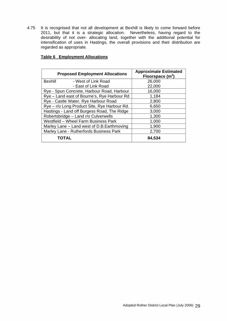
Adopted Rother District Local Plan (July 2006) 29
4.75 It is recognised that not all development at Bexhill is likely to come forward before
2011, but that it is a strategic allocation. Nevertheless, having regard to the desirability of not over- allocating land, together with the additional potential for intensification of uses in Hastings, the overall provisions and their distribution are regarded as appropriate.
Table 6 Employment Allocations
Proposed Employment Allocations Approximate Estimated Floorspace (m2)
Bexhill - West of Link Road - East of Link Road
26,00022,000
Rye - Spun Concrete, Harbour Road, Harbour 16,000 Rye – Land east of Bourne’s, Rye Harbour Rd 1,184 Rye - Castle Water, Rye Harbour Road 2,800 Rye – r/o Long Product Site, Rye Harbour Rd. 6,650 Hastings - Land off Burgess Road, The Ridge 3,000 Robertsbridge – Land r/o Culverwells 1,300 Westfield – Wheel Farm Business Park 1,000 Marley Lane – Land west of D.B.Earthmoving 1,900 Marley Lane - Rutherfords Business Park 2,700
TOTAL 84,534

Adopted Rother District Local Plan (July 2006) 30
5. GENERAL DEVELOPMENT CONSIDERATIONS
5.1 Policies contained in the previous section of the Local Plan, together with relevant
national, regional and Structure Plan policies will be instrumental in determining the principle of development in particular locations. However, in determining whether a particular development proposal can be accommodated, it also needs to be considered against a range of more detailed considerations.
5.2 Through the Local Plan, the Council is seeking to ensure high standards of
development that respect and contribute to its setting and promote sustainable development. This embraces conserving landscape character and bio-diversity as well as making most efficient use of finite water and energy resources. It also embraces the need to foster local identity and safeguard amenities.
5.3 The following policy is applicable to all development proposals. It recognises that all
aspects of a development need to be satisfactorily addressed in order for it to be acceptable and successfully integrated within its setting. Such aspects include the scale, form, layout, design and materials of development and landscape treatment of external areas, as well as the availability of adequate infrastructure and services necessary to serve it.
Policy GD1 All development should meet the following criteria:
(i) it meets the needs of future occupiers, including providing appropriate amenities and the provision of appropriate means of access for disabled users;
(ii) it is in keeping with and does not unreasonably harm the
amenities of adjoining properties;
(iii) it provides for adequate and safe access by all relevant modes of transport, appropriate parking provision, in accordance with Policy TR3 and does not result in unacceptable traffic or transport conditions;
(iv) it respects and does not detract from the character and
appearance of the locality;
(v) it is compatible with the conservation of the natural beauty of the High Weald Area of Outstanding Natural Beauty;
(vi) it respects the topography, important views to and from
the site and retains site features that contribute to the character or amenities of the area;
(vii) it protects habitats of ecological value and incorporates,
wherever practicable, features that enhance the ecological value of the site, with particular regard to wildlife refuges or corridors, or fully compensates for any necessary loss;

Adopted Rother District Local Plan (July 2006) 31
(viii) it does not prejudice the character, appearance or setting of heritage features, notably scheduled ancient monuments and sites of archaeological importance, listed buildings, conservation areas, registered historic parks and gardens, the registered battlefield at Battle, or other buildings and spaces of historic importance;
(ix) the infrastructure and facilities necessary to serve the
development are available, or suitable provision is made as part of the development, in accordance with Policy GD2;
(x) it provides adequate and appropriate means for foul and
surface water drainage, with suitable alleviation and mitigation measures where necessary and does not prejudice water quality;
(xi) it is compatible with deterring crime, including maximising
opportunities for natural surveillance of public places;
(xii) it promotes the efficient use of energy and water through the layout and design of buildings.
(xiii) it properly addresses any known or suspected
contamination of the site, or threat from landfill gas, through site investigations and suitable remediation;
(xiv) where significant development of agricultural land is
unavoidable, it makes use of poorer quality land (grade 3b, 4 and 5) in preference to that of higher quality except where this would be inconsistent with other sustainability considerations;
(xv) it takes account of flood risk and in the areas of flood risk,
as shown on the Proposals Map, it is expected to minimise and manage the risk to flooding
5.4 These considerations are elaborated upon below and, in some cases, by further
policies in the Plan. It is also proposed to prepare planning guidance on certain matters including parking standards and design/landscape considerations.
Protecting amenities 5.5 All development should be fundamentally “fit” for its purpose. Especially for
residential development, it should be capable of accommodating the reasonable expectations of likely occupiers, including in terms of indoor and outdoor space, personal safety and not unduly affected by adjacent intrusive uses and buildings.
5.6 Developments also need to cater for practical needs, such as adequate parking and
access arrangements, refuse and recycling facilities and open space. Further elaboration is given in Section 7 to the retention and provision where necessary of open space and other recreational facilities. Section 8 elaborates on transport matters including sustainable travel objectives. The Structure Plan and Waste Local Plan include policies to minimise waste during development and to have regard to the provision of facilities within developments so as to assist recycling; relevant adopted Waste Local Plan policies are included in Appendix 2 of this Plan.

Adopted Rother District Local Plan (July 2006) 32
5.7 Conversely, the amenity of neighbouring properties needs to be protected. Hence, the impact of development needs to be carefully considered in relation to issues such as loss of light and privacy, avoiding an overbearing presence and otherwise causing intrusion such as through noise, activity at unsocial hours, lighting, etc.
5.8 The Safer Rother Partnership has produced a local Crime and Disorder Reduction
Strategy. This includes looking towards making properties more secure, car parks safe and promoting a wide provision of recreational and sporting activities, amongst other measures. These considerations will be assessed alongside national ‘Secured by Design’ guidance.
Design and respecting local character 5.9 A feature of the District is the diverse landscape character, which is the result of a
combination of topography, agriculture and historic influences. The greater part of the District, over 80%, falls within the High Weald Area of Natural Beauty, as shown on Figure 4. Its landscape is recognised as being of national importance, where priority is given to the conservation of its natural beauty.
5.10 There are increasing pressures on the landscape from new development proposals
and changes in agricultural practices that tend to an inappropriate fragmentation of the countryside. Landscape character can be eroded by a combination of individually limited changes and care will be taken to avoid this. Structure Plan policies EN2 – EN9 deal with conserving and enhancing landscape quality and character, particularly within the High Weald Area of Outstanding Natural Beauty, the coast and urban fringes. The District’s coast is covered by the South Foreland to Beachy Head Shoreline Management Plan which addresses coastal protection issues.
5.11 A large amount of tree and woodland cover, estimated to be 19% of the District, is a
defining landscape characteristic and one that makes an important contribution to local amenities in both urban and rural contexts. Landscaping proposals will often form an important component of development schemes, enabling them to blend in with their setting. They should generally retain existing trees and utilise indigenous species. A detailed tree survey will normally be required with a planning application.
5.12 In addition to protecting sites of recognised nature conservation value in accordance
with Policy DS1, all new development may provide some wildlife habitats. This can be achieved by retaining features such as trees and hedgerows, ponds, small woodlands, streams and ditches, as well as by introducing features that provide new habitats. An ecological survey will be sought where a site is or is likely to be of ecological value.
5.13 Structure Plan policies, notably EN17 to EN21 provide protection for areas and
features of nature conservation importance. 5.14 The Sussex Biodiversity Partnership has produced the Sussex Biodiversity Action
Plan that provides a framework for conservation within the County. As part of this process the Partnership is producing a series of Habitat and Species Action Plans, which deal with the conservation of selected habitat types and species. The Council would have regard to the Sussex Biodiversity Action Plan when dealing with development proposals. In their absence, regard would be had to the relevant national Action Plan.
Adopted Rother District Local Plan (July 2006) 33
5.15 Habitat types that are the subject of current Sussex Biodiversity Action Plans are: arable land, coastal, coastal vegetated shingle, floodplain grassland, hedgerows, marine, reedbeds, rivers and streams road verges, saline lagoons, standing open water, unimproved neutral grassland or meadows, urban and woodland.
5.16 When dealing with development sites which contain protected species an ecological
survey should be carried out before an application is submitted. It is essential when dealing with species that have a European protection, such as great crested newt and species of bats, that a thorough survey should accompany the planning application and there is a strong case for this with nationally protected species.
5.17 It is proposed to produce a supplementary planning document on landscape design,
drawing on the principal landscape characteristics of the area. This will elaborate on the need for landscape appraisals for developments in environmentally and visually sensitive locations.
5.18 Rother District is fortunate in the legacy that exists in terms of the quality of the built
environment. Towns and villages have grown up over time and display a special relationship with their surroundings. The pattern, form and appearance and use of buildings and spaces are peculiar to each location and contribute to the unique sense of place and cultural identity.
5.19 Good design should respect the character of its setting, whether urban or rural, and
can make a positive contribution to reinforcing local distinctiveness. This should still allow room for imaginative design solutions that respond sensitively to the site and setting. Particular care needs to be taken to ensure that developments do not create an alien, cramped appearance or, in some locations such as rural settings, an equally inappropriate suburban appearance. Where an area has a well-defined and distinctive character, particular care should be taken to maintain it. This will bear upon not only the layout and design of buildings, but also the treatment of external areas, which should respect landscape character. Where a development proposal would be likely to require external lighting that can be subject to planning control, regard is to be had to its impact on the character and appearance of the surroundings to include the avoidance of unnecessary light spillage into the surrounding area and into the night sky. Structure Plan Policy EN14 is also relevant (see Appendix 2).
5.20 High standards of design and layout are applicable to all developments, large and
small, housing commercial and leisure. The Council will prepare a planning application validation guide which will set out, inter alia, the circumstances when an application should be accompanied by a design statement to address the relationship of development proposals to their surroundings
5.21 The historic, architectural and archaeological heritage of the District contributes much
to the high quality of its built environments. A considerable number of buildings are ‘listed’ (currently 2,114) by government, as being of special architectural or historic interest. There are also many more, the continued survival of which is important because of the contribution they make to the character and appearance of Rother District.
5.22 Ten Conservation Areas of special architectural and historic interest are currently
designated: at Battle, Bexhill Old Town, Bexhill Town Centre, Burwash, Northiam, Robertsbridge, Rye, Sedlescombe, Ticehurst and Winchelsea. It is also intended to designate Conservation Areas at Brede, Brightling, Dallington, Ewhurst Green, Hurst Green, and Salehurst. The designation of further conservation areas and review of

Adopted Rother District Local Plan (July 2006) 34
existing areas may also be considered during the Plan period, subject to detailed assessments.
5.23 PPG15: Planning and the Historic Environment provides a full statement of Government policies for the identification and protection of historic buildings, conservation areas and other elements of the historic environment, including historic parks and gardens, and battlefields.
5.24 There are the 39 Scheduled Ancient Monuments of national importance. Also, there
are numerous Sites of Archaeological Interest, identified by East Sussex County Council. English Heritage has also compiled registers of nationally important historic parks and gardens and battlefields. There are seven designated parks and gardens in the District: Asburnham Place, Batemans, Battle Abbey, Brickwall, Great Dixter, Brightling Park and Ticehurst House, and one battlefield site, at Battle!
5.25 Structure Plan policies EN22 – EN24 already provide quite detailed statutory
‘development plan’ policies that apply within Rother District, while PPG16: Archaeology and Planning provides advice on how archaeological remains should be preserved and recorded and also on the handling of such discoveries under planning processes. (See Appendix 2 for the web links to these documents).
Ensuring availability of infrastructure and services 5.26 “Infrastructure” is taken to include transport links and access arrangements, water
supply, flood defences, surface and foul water drainage, education provision, public open space and leisure facilities, health care, community buildings (such as village halls), waste disposal and recycling facilities. For larger developments, it may also relate to the emergency services, libraries and social services.
5.27 In order to make certain that any development is sustainable in the longer term, it is
essential that adequate infrastructure and services are made available. This will help to ease any added pressure on existing services and infrastructure, which is inevitable with any new development.
5.28 Therefore, development will only be permitted when it is satisfactorily demonstrated
that the infrastructure and facilities required to service the development are available or will be provided. Such provision may require funding contributions, off-site works, the provision of land or phasing which will be secured normally by legal agreements.
5.29 As far as practicable at the present time, the scope of improvements to infrastructure
and services considered necessary to justify the release of allocated sites for development, is highlighted in the relevant settlement section. These will be kept under review and may be updated by the Local Planning Authority, informed by assessments undertaken by the relevant infrastructure and service providers.
5.30 In view of the potential for mixed-use developments and other developments involving
land in separate ownerships, it is important to ensure that a co-ordinated approach to infrastructure provision is taken. Where a site, either defined in the Local Plan or otherwise proposed for development, comprises land in separate ownerships, it must be demonstrated that proposals will secure the provision of necessary infrastructure to serve the whole site.
5.31 It is proposed that a supplementary planning document will be prepared on
determining infrastructure and service requirements and securing development contributions in line with the policy below.

Adopted Rother District Local Plan (July 2006) 35
Policy GD2 Development will only be permitted when it is satisfactorily
demonstrated that the infrastructure and facilities required to service the development are available or will be provided.
Such provision may require funding contributions, off-site works
the provision of land or phasing, which will be secured normally by legal agreements.
Where a site, either defined in the Local Plan or otherwise
proposed for development, comprises land in separate ownerships, it must be demonstrated that proposals will secure the provision of necessary infrastructure to serve the whole site.
5.32 As regards drainage, it will be expected that foul sewerage is connected to the public
mains system. Only exceptionally will other provision be allowed, where it is not feasible to connect. Drainage principles will need to be agreed before the grant of planning permission.
5.33 Surface water must also be properly dealt with. The rate of run-off from
developments will be carefully controlled to avoid any adverse impacts on watercourses and increasing the risk of flooding downstream. This may involve mitigation or alleviation measures. The use of appropriate sustainable drainage systems (SUDS) will be encouraged in this respect (to include adequate arrangements for their future maintenance), as would rainwater and grey water recycling and other water efficiency techniques. Adequate access should be retained to all watercourses for maintenance purposes.
5.34 Development must not prejudice the integrity of floodplains or flood defences. PPG25
defines areas at flood risk associated with main rivers and these are shown on the Proposals Map. It is noted that the boundaries of these areas are only indicative, and that a range of considerations will need to be taken into account for a particular development. Any flood risks associated with ordinary watercourses, or problems with surface water drainage, will also be considered in relation to any development proposal. PPG25 advice will be followed, on the basis of consultation with the Environment Agency. An assessment of flood risk and run-off implications may be required for certain applications, notably those within floodplains. The uncertainties that are inherent in the prediction of flooding must be recognised and that flood risk is expected to increase as a result of climate change. The Council will apply the precautionary principle to the issue of flood risk, using a risk-based search sequence to avoid such risk where possible and managing it elsewhere.
5.35 All development should meet the transport and access demands they create. These
should be met in ways that take account of the need to promote journeys other than by car but may also entail highway improvements where necessary to avoid prejudice to road safety or unacceptable harm to the free flow of traffic. It may be necessary, particularly for larger developments, for the implications to be identified by a transport assessment. In line with PPG13, the submission of travel plan may be required alongside a planning application for developments likely to have significant transport implications. Measures to promote sustainable transport together with car parking provision are addressed in Section 8.

Adopted Rother District Local Plan (July 2006) 36
Making best use of environmental resources 5.36 Energy efficiency is primarily secured through the Building Regulations. Emerging
regional policy looks to strengthen the regard to the orientation of buildings for maximum solar gain, promoting and advising on various schemes and services, together with promoting Combined Heat and Power.
5.37 The Council is supportive of such initiatives, while recognising that there will be
circumstances, notably where listed buildings and Conservation Areas are affected, where solar panels particularly must respect the historic character. It is anticipated that local policies may need to be further reviewed in the light of forthcoming revised Government and regional guidance, will need to be updated.
5.38 Energy efficiency in new development may look to be improved through design and
orientation, as a means of achieving maximum passive solar gain. Further consideration will be given to supplementary planning guidance as more research and experience is forthcoming.
5.39 The quality of the physical environment – buildings, street and areas – should meet
people’s expectations. The Council is currently involved in a partnership with English Heritage and others to encourage investment in commercial properties in Bexhill town centre. Environmental enhancement is also a key element in efforts to regenerate the Rye Harbour Road area.
5.40 The Council will continue to promote the environmental enhancement of buildings and
the streetscape through refurbishment, redevelopment, conservation and regeneration schemes, liaison with the Highway Authority and other providers of street furniture and through planning enforcement, as appropriate, where such buildings or streets detract from the physical and visual qualities of an area. Particular locations will be identified and proposals developed through development briefs, regeneration strategies and local “action plans”.

Adopted Rother District Local Plan (July 2006) 37
6. HOUSING DEVELOPMENTS 6.1 Recent Government policy statements have emphasised the importance it attaches to
creating mixed and inclusive communities, including through a better mix of housing – in terms of size, type and affordability.
6.2 Key references are PPG3: Housing, the Communities Plan and, in respect of
affordable housing, Circular 6/98. Regard is also had to recent draft guidance that will replace the Circular and the detailed references to affordable housing in PPG3. RPG9 and Structure Plan policies also strongly promote a wider choice and availability of housing.
6.3 This Plan includes policies that accord with these strategic expectations and reflect
the local priority to improve the quality, range, and affordability of housing, as expressed by the Local Strategic Partnership and the Council itself.
Affordable housing 6.4 Government guidance, notably PPG3: Housing, makes clear that the planning system
and local plans specifically have an important part to play in providing affordable housing. Plans should seek a proportion of affordable housing in suitable developments where a local need has been demonstrated, and allow for affordable housing schemes as “exceptions” to normal planning policies in appropriate circumstances.
6.5 Affordable housing is regarded as that which is provided for local people (or key
workers) who are unable to meet their housing needs in the housing market without a level of subsidy because to do so would require more than 25-30% of their net household income.
6.6 Housing Needs Surveys of Rother District have been undertaken in 2001 and in 2005
in order to better understand the housing requirements of local people. The findings of both surveys were statistically robust. The 2001 Survey identified an expressed need from existing and concealed households for 200 affordable units a year from all sources over a 5-year period. The 2005 Survey confirmed this scale of need, revealing a net annual need for 256 units up to 2011.
6.7 Such clear evidence of a substantial number of people living in the District who
cannot, or could not, afford to purchase a house on the open market is of major concern. It impacts on the ability to maintain family and social networks and an adequate workforce. It encourages longer distance commuting.
6.8 It is considered that the target proportion of affordable housing sought as part of
qualifying residential developments, including where part of mixed-use schemes, should be set at 40% in both towns and villages. These percentages reflect the high level of affordable housing need, the widespread support for addressing it expressed by local people, the Council’s Housing Strategy and its priority in the Council’s corporate policy.
6.9 Affordable housing provision at a rate below 40% will only be acceptable if to meet
the 40% requirement would render the development of the whole site uneconomic. In such circumstances, applicants will be required to provide clear evidence that the

Adopted Rother District Local Plan (July 2006) 38
development of the site would be unviable, including by the submission of financial information as necessary. These provisions apply to housing sites allocated in this Plan as well as to housing developments elsewhere in the Local Plan area for which planning permission is sought.
6.10 It is considered that the threshold for the provision of affordable housing should be 15
dwellings in the towns and 5 dwellings in the villages, or their equivalent site areas. The urban threshold is consistent with the most recent Government advice, while the rural threshold also has regard to the generally smaller size of sites that come forward and which, collectively, can make a worthwhile contribution towards affordable housing needs.
6.11 Given the above policies, as well as the overall scale of housing in the District up to
2011 and housing market and economic conditions, it is considered that an appropriate target for affordable housing through the planning system should be 450 homes between 2004 and 2011. This figure is based on a minimum density of development on many allocated sites of 30 dwellings per ha and also assumes that the pattern of windfall sites coming forward will mirror that of previous years. Those affordable dwellings resulting from existing commitments and from the exception sites policy would be in addition to this figure.
6.12 The Council supports the Government’s presumption that affordable housing should
form part of the proposed development of a site. A financial contribution to off-site provision in lieu of on-site provision will only be acceptable where the proponent demonstrates that there is a genuine and insurmountable obstacle to satisfactory provision on site and where off-site provision will result in at least as great a contribution to meeting local needs. In this context, regard should be had to the amount of affordable housing to be achieved as a percentage of the overall housing numbers both on- and off-site.
6.13 The Council’s Housing Services Division will advise on the types of affordable
housing that are needed on a particular site at the appropriate time. This will be informed by the Housing Register and homelessness statistics, as well as the Survey findings. This will include a proportion of small unit accommodation, including flats, for young people and the elderly, as well as family homes.
6.14 The policy does not specify the tenure of affordable housing, as this will need to take
account of the circumstances of individual locations and development proposals. However, it should primarily consist of housing for rent, typically managed by a Registered Social Landlord (and in all circumstances with the prior approval of Rother District Council) since this is the only option available to a large proportion of people identified as being in greatest housing need. An element of shared equity housing (normally also provided by a Registered Social Landlord and always with the prior approval of Rother District Council), and other ‘intermediate’ forms of housing such as sub-market renting, low- cost home ownership, and shared ownership may be considered but must be accessible to people whose low household incomes prevent them from competing in the open housing market. These should be targeted at key workers and to assist other local people’s aspirations to “get on to the housing ladder”.
6.15 A Supplementary planning document will be produced to elaborate on the delivery of
affordable housing.

Adopted Rother District Local Plan (July 2006) 39
Policy HG1 Affordable housing On housing or mixed-use development sites of 0.5 hectares or
more or housing developments of 15 or more dwellings, within the development boundaries of the towns of Bexhill, Battle and Rye, 40% of the total number of dwellings to be provided shall be affordable housing for local people.
On housing or mixed-use development sites within the
development boundaries of villages of 0.2 hectares or more, or housing developments of 5 or more dwellings, 40% of the total number of dwellings to be provided shall be affordable housing for local people.
Affordable housing provision below 40% of the total number of
dwellings will only be accepted where the applicant fully and financially demonstrates that 40% provision will make the development of the whole site uneconomic based on the current housing market and all the costs of the development.
Policy HG2 In exceptional circumstances, planning permission may be granted for residential development outside development boundaries in order to meet a local housing need among those people unable to compete in the normal housing market. Proposals for development will be considered in the context of the following:
(i) There should be clear evidence of an unsatisfied housing
need in the town/village or parish that cannot be met through normal market mechanisms;
(ii) The proposed development should be of a size, cost and
type appropriate to those people in local housing need established in (i) above;
(iii) Any proposal should ensure that occupation can be
controlled through appropriate legal agreements to meet the local housing needs of those people unable to compete in the normal housing market in the town/village or parish both now and in the future;
(iv) The proposed development should be well located within
or adjacent to an existing settlement and be of an appropriate scale and character in keeping with existing development in the locality and normally provide good access to local facilities, e.g. shops and schools;
(v) The proposed development should not be intrusive in the
landscape and should be in keeping with the character of the surrounding development and locality;

Adopted Rother District Local Plan (July 2006) 40
(vi) The proposed development should meet normal local planning and highway authority criteria for access, parking, retention of trees, landscaping and impact on neighbouring properties;
(vii) A legal agreement will be required to secure the above
objectives.
Housing mix 6.16 A notable finding of the Housing Needs Survey is the high proportion of respondents
who need only 1 or 2 bedrooms, which is consistent with the high proportion stating a preference for a flat
6.17 This apparent need for smaller homes starkly contrasts with the general desire of
housebuilders to build larger ‘executive’ properties. In view of these circumstances, together with Government encouragement to deliver a better mix of housing, it is considered appropriate to have a specific policy that seeks to ensure a mix of housing types and sizes in new developments irrespective of tenure and affordability.
6.18 The appropriate proportion will vary depending on individual circumstances, but a
minimum of 30% of all houses and flats is justified by the housing needs assessment and would contribute to balanced communities.
6.19 The Housing Needs Survey illustrated a local need for housing for people with special
needs, especially people with disabilities and the frail elderly. This can be expected to increase as the number of people over 85 years old is forecast to increase by 13% up to 2011. The quantification of the housing needs of these and other groups, including the need for market housing, and its distribution across the District, will be the subject of a more comprehensive Local Housing Assessment that will inform the Plan Monitor and Manage process for housing provision and the preparation of the forthcoming Local Development Framework. In the meantime the inclusion of smaller units in most housing developments in accordance with Policy HG3 would help to meet the need of the elderly as well as other small households. However the need for further provision of sheltered housing for people with special needs is likely to be identified by the Assessment. Whilst some provision can be expected on windfall sites, it will also be encouraged on allocated housing sites in the towns and villages where a need exists and the sites are suitable having regard to considerations of design, layout and accessibility to services and facilities.
Policy HG3 New housing developments should provide a mix of housing types and sizes, with at least 30% one and two bedroom dwellings in schemes above the thresholds in Policy HG1, unless a local housing needs assessment indicates that this is not appropriate.

Adopted Rother District Local Plan (July 2006) 41
Layout and design 6.20 In planning new residential developments, it is important to appreciate that they will
provide the living environments for people for decades to come. The Council is committed to creating attractive high quality living environments in which people choose to live and better respect local distinctiveness.
6.21 A common criticism of many housing developments is that they have tended to pay
little regard to their context, in favour of a more standardised “product”. The result is that housing estates are much the same everywhere. The larger size of dwellings and a limited mix of house types have been contributory factors, as have suburbanising highway design standards.
6.22 Government and other guidance now recognises the importance of respecting local
building traditions, street patterns and building forms when planning new development. They also promote a more efficient use of land, mixed use developments, community facilities, public transport, pedestrian and cycle links, sensitive layout and design and better green spaces. It is vital to highlight and require full regard to such local layout and design references, especially if new development is to be sympathetically assimilated into villages.
6.23 Attention is drawn to the following documents that provide useful guidelines for the
layout and design of new development: Better Places to Live (DTLR, 2001) ‘Places, Streets and Movement’ (DETR, 2001), ‘By Design’ (DETR/CABE, 2001) and the ‘Urban Design Compendium’ (EP/HC, 2000).
6.24 In order to encourage high quality residential environments in areas proposed for
housing development, developers will be expected to submit a design statement in respect of new housing developments, in line with the provisions of PPG3. Generally applicable development control criteria that impact on layout and design are put forward in Section 5.
Policy HG4 New housing developments will be permitted where their layout and design provides sustainable residential environments, including by demonstrating the following principles:
(i) creation of a strong sense of place that relates well to the
existing street pattern; (ii) provision of linkages to existing development, especially
to local services;
(iii) priority to pedestrians in highway design and ready access to bus services;
(iv) respect for the context of the development including,
where appropriate, for local vernacular building designs, styles, traditional forms of construction and materials;
(v) provision of new community facilities appropriate to
securing sustainable development, wherever practicable, and with good links to the areas they serve;

Adopted Rother District Local Plan (July 2006) 42
(vi) subject to any over-riding environmental considerations, making best use of land by achieving an overall net density of at least 30 dwellings per hectare, with higher densities in locations more accessible to frequent public transport routes and a range of local facilities;
(vii) a strong landscape framework formulated at the outset,
making best use of existing landscape features;
(viii) in larger housing developments, a layout that is both coherent and creates identifiable individual housing areas by making good use of trees and hedgerows, open spaces, natural features, road networks, dwelling layouts and design;
(ix) suitable provision is made for public open space,
including play space in accordance with Policy CF4;
(x) the visual and amenity impact of parked cars is minimised, while still providing adequate provision in accordance with Policy TR3;
(xi) informal surveillance of open areas and transport
corridors is encouraged.
Residential mobile homes 6.25 Many existing residential mobile homes provide a valuable source of affordable
housing which should not be diminished by their replacement with permanent dwellings. However, in general, new residential caravan sites and mobile homes would not be in keeping with the environment of the District. Their form and appearance are incompatible with the character of rural areas, especially the countryside of the High Weald, and they constitute inappropriate, sporadic and unsustainable development. New development for this purpose will thus usually be unacceptable unless it would significantly improve the appearance of an existing mobile home site and would otherwise accord with Plan policies including Policy GD1. The Plan seeks to ensure that housing needs are met by the construction of permanent dwellings.
6.26 A specific exception to this is where such accommodation is essential in association
with the running of a farm, woodland or other rural enterprise, in accordance with PPG7 and Policy HG10. On sites within development boundaries, residential mobile homes will be treated on their merits against the relevant planning criteria in Policy GD1.
Policy HG5 Within development boundaries, proposals for residential mobile homes will be considered on their merits against the other policies set out in the Plan.

Adopted Rother District Local Plan (July 2006) 43
Outside development boundaries, additional residential mobile homes will not be permitted unless the development would accord with Policies HG6 or HG10 or would result in a significant improvement in the appearance of an existing mobile home site and otherwise meets the policies of the Plan.
The replacement of existing residential mobile homes by permanent dwellings will not be permitted unless the mobile home was provided outside a development boundary on a temporary trial basis under Policy HG10 (iii) and the proposed permanent replacement would satisfy the same policy criterion.
Sites for gypsies and travelling showpeople 6.27 Government advice, in Circular 1/94: Gypsy Sites and Planning, states that the
planning system should recognise the need for accommodation consistent with the nomadic lifestyle of gypsies. There is a small flow of gypsies through the District and the Council considers that sufficient sites have been provided to meet the needs of gypsy families. In the absence of a clearly identified local demand, it is considered most appropriate to set out a criteria-based policy against which any future proposals by gypsies seeking suitable sites for accommodation can be considered.
6.28 Similar considerations apply in respect of sites for travelling showpeople, for which
Government advice is contained in Circular 22/9. Although their work is of a nomadic nature, showpeople nevertheless require secure, permanent bases for the storage of their equipment and more particularly for residential purposes. In Rother, there are no recorded bases, or "winter quarters" as they are generally known. There is no particular known requirement for such provision, it is considered to provide a criteria-based policy framework in line with government guidance.
Policy HG6 Proposals for new gypsy sites, extensions to existing gypsy sites
and sites for travelling showpeople will be permitted provided the following criteria are met:
(i) There is no adverse impact on the character of the
countryside, particularly in the High Weald Area of Outstanding Natural Beauty;
(ii) The local environment and residential amenities will not be
adversely affected;
(iii) There is a satisfactory means of vehicular access and the local road network is adequate;
(iv) The site is conveniently located in relation to schools and
other community facilities. Retention of housing stock
6.29 The Council is keen to maintain the existing stock of housing, particularly housing
suitable for single family use. This is consistent with the Government objective of making best use of existing land and buildings and can contribute to social inclusion.

Adopted Rother District Local Plan (July 2006) 44
6.30 While there is sometimes potential to satisfactorily redevelop existing housing sites within development boundaries to make better use of urban land, in accordance with other policies (notably HG1 and HG4), the loss of housing is generally to be resisted unless there are wider benefits.
Policy HG7 The loss of residential accommodation will be resisted (by
change from another use or by redevelopment) unless there are special circumstances, namely:- (i) that the residential use is not appropriately located;
(ii) that the building is unsuitable for residential use in its
present form and is not capable of being readily improved or altered in order to make it suitable; or
(iii) that the retention of the building or use for residential
purposes would prevent an important development, redevelopment or other change of greater benefit to the community.
Extensions to dwellings 6.31 Extensions and alterations to existing houses, including ancillary buildings, generally
represent an effective means of maintaining, improving and increasing the housing stock, as well as enabling residents to better meet their housing needs without moving. Such proposals represent a major source of applications for planning permission.
6.32 Many of the considerations applicable to all developments, set out at Policy GD1, are
applicable to extensions, but a specific policy that highlights the main issues is considered appropriate. The main thrust of this is to ensure that extensions do not dominate the existing dwelling but, rather, are “visually subservient” to it and hence add to, and not detract from, its character and appearance.
6.33 In addition, in rural locations, there is a danger that unsympathetic extensions,
individually and cumulatively, can erode the rural scene, either by changing the character of historic or vernacular buildings or by their visual impact on the wider countryside setting.
Policy HG8 Proposals to extend or alter an existing dwelling will be permitted
where they are in keeping with the character of the existing dwelling and its surroundings in terms of its size, style, design and materials, as well as protecting the amenities of adjoining properties and meet other criteria in Policy GD1.
In countryside locations, particular care will be given to ensure that the extension or alteration is not intrusive in the landscape, particularly in the High Weald Area of Outstanding Natural Beauty. Extensions or alterations to properties that have previously been converted to residential use will only be permitted where it is demonstrated that they will not adversely affect its character or appearance as a rural building.

Adopted Rother District Local Plan (July 2006) 45
Extensions to residential curtilages 6.34 Some householders and other property owners in Rother District, particularly in
countryside locations, seek to extend their curtilage, typically to provide additional accommodation for storage space or simply to provide an enhanced garden area. Accordingly, a policy framework is considered necessary.
6.35 While such extensions of residential curtilages can be acceptable, the prime objective
in rural areas is to conserve the character of the countryside. This is in fact a statutory objective in the High Weald Area of Outstanding Natural Beauty and, generally, the countryside is valuable for its own sake. The erosion of countryside character, albeit incremental, and the potential suburbanising effect caused by the enlargement of residential curtilages should be avoided.
Policy HG9 Extensions of the curtilages of existing dwellings in the
countryside will not be permitted unless the extension:
(i) is modest in area, and the change of use and associated domestic paraphernalia does not harm the rural character of the area; and
(i) is to a natural boundary or is a logical rounding off.
Dwellings in the countryside
6.36 As has been highlighted in Section 4, the countryside is a highly valued asset. Only
very limited developments are consistent with maintaining its inherent qualities and character. Other policies provide for diversification of the rural economy to help maintain its sustainability.
6.37 In relation to housing, the principle of resisting inappropriate and unnecessary
development in the countryside means that this will not normally be acceptable outside development boundaries.
6.38 The circumstances in which residential development will be allowed in the countryside
will be very limited. The Structure Plan contains three exceptions - affordable housing for local needs, accommodation demonstrated to be essential to an enterprise necessarily in the countryside and the conversion of non-residential buildings which make a valuable contribution to the rural scene. In addition to these, it is the intention to allow the replacement of an existing dwelling with one of a comparable size and character.
6.39 This policy should be applied sensitively and should not tend to the loss of traditional
vernacular buildings, the retention of which is covered by Policy GD1, nor have a suburbanising effect on the character of the countryside.
Policy HG10 Proposals for new dwellings in the countryside will be refused
unless it:
(i) is for the replacement of an existing dwelling on a one for one basis, subject to meeting the criteria at Policy GD1, the replacement dwelling being within the same curtilage and of a comparable size; exceptionally, a somewhat

Adopted Rother District Local Plan (July 2006) 46
larger dwelling may be acceptable where it would be more in keeping with the character of the locality in terms of its siting, design and materials;
(ii) is the conversion (without the need for substantial
rebuilding) of a building in accordance with Policy HG11;
(iii) can be demonstrated by the applicant to be essential for the running of an enterprise which must be in a countryside location and is of an appropriate size and directly related to the enterprise; or
(iv) is housing for local people unable to compete in the local
housing market, subject to the criteria in Policy HG2 above;
(v) is the conversion or sub-division of an existing larger
property where it is the only effective means of reusing it and meets the criteria in Policy GD1.
6.40 Proposals under (iii) above, including for temporary accommodation, will also be
considered having regard to Government policies in PPS7: Sustainable Development in Rural Areas. Extensions and alterations to dwellings in the countryside, including ancillary buildings, will be considered in relation to Policy HG8 above.
6.41 There is a preference for employment, tourism or recreational re-use of buildings in
the countryside over residential re-use. This is to benefit rural economic and community activity and because of the potential for residential conversions to harm the fabric and character of historic buildings. However exceptions may be justified including where employment or tourism re-use cannot be secured. Further guidance will be set out in a Supplementary Planning Document. Traditional farm buildings raise particular difficulties and care is needed if their simple vernacular appearance is not to be adversely affected by unsympathetic conversion proposals. In addition to meeting the policy criteria set out in Policy EM3, proposals for conversion to residential use will be expected to be in accordance with the following policy.
Policy HG11 Residential re-use and adaptation of buildings in the countryside will not be permitted unless:-
(i) the building makes a valuable contribution to the rural
scene and residential re-use is the only means of retaining it. The applicant should demonstrate that every attempt has been made to secure suitable employment or tourism re-use unless such a use would be inappropriate in that location; or
(ii) residential re-use and adaptation is demonstrated to be
an essential part of a scheme for business re-use which must be in a countryside location and the residential element of the scheme must be of an appropriate size and directly related to the enterprise; and

Adopted Rother District Local Plan (July 2006) 47
(iii) in either case, it does not involve the creation of a residential curtilage harmful to the character of the building or the extension of the building or the addition of new buildings.
Any permission will be subject to conditions requiring strict adherence to the deposited proposals, landscaping and the removal of permitted development rights for alterations, extensions and buildings within the curtilage.

Adopted Rother District Local Plan (July 2006) 48
7. COMMUNITY FACILITIES 7.1 The Plan’s vision places “community development” at its heart. The Council aims,
through this Plan, to foster the provision of a broad range of facilities that contribute to the vitality of communities. This includes community buildings, leisure and recreation facilities, shops and local services, as well as education and primary health provision.
7.2 Recreational provision embraces sports facilities and play space together with other
open spaces used for leisure purposes, such as parks and gardens, as well as semi-natural and amenity greenspaces/corridors. Allotments are a further, specific form of open space. Such facilities are a key component of the social “infrastructure” of towns and villages and play a major role in terms of community cohesion and the “liveability” of places, as well as in health and well-being.
7.3 The importance of ensuring sufficient well-managed recreation facilities is
emphasised in Government policy guidance PPG17: Planning for Open Spaces, Sport and Recreation. The Council itself seeks to provide for the full range of people’s recreational and leisure needs in a manner compatible with the natural resources and environmental qualities of the area.
New and improved community facilities
7.4 A need for new village halls has been demonstrated at Etchingham and Flimwell.
Specific provision is through mixed-use allocations at Policies VL2 and VL4. Elsewhere, contributions to new or improved village halls may be sought from housing development in villages where a need is identified, in accordance with Policy GD2.
7.5 Village halls and community centres can be regarded as vital community facilities.
Also, valuable in community life are churches, nursery and pre-school groups, the uniformed associations (i.e. guides, scouts, etc) and similar organisations for significant sections of the population. These generally rely on local voluntary involvement and promote a sense of community.
7.6 Where proposed development has implications for community facilities that can be
identified now, then the need for contributions to new or enhanced facilities are identified in relation to the relevant allocation. In addition, policies for new or improved community facilities and the treatment of any development proposals involving their loss, which may come about during the Plan period are considered below. Section 5 contains a policy that sets out the basis for requiring contributions to such facilities from new development where appropriate. Taken together, these policies should maintain and strengthen local communities.
7.7 Where proposals come forward for community facilities for which there is a
demonstrable local need, it is considered appropriate, where necessary, to allow some flexibility in relation to locations not within but adjacent to development boundaries. At the same time, such proposals should be seen to be consistent with other policies of the Plan, notably in relation to maintaining the character and setting of settlements.

Adopted Rother District Local Plan (July 2006) 49
7.8 The exception to normal planning policies provided to proposals for community
facilities on sites outside development boundaries should not extend to enabling development. The Council takes the view that a financial advantage of enabling development could rarely justify the resultant conflict with the good planning of the area, as reflected by the Local Plan policies.
Policy CF1 Proposals for new or improved community facilities will be permitted within development boundaries where they accord with the criteria at Policies GD1 and DS1. Such facilities will be permitted outside development boundaries where, in addition:
(i) there is a demonstrable local need, having regard to the
characteristics of the population, the results of any public surveys and recognised standards of provision;
(ii) there is no scope for the need being met within the
development boundary;
(iii) the proposal is demonstrated to provide significant community benefits;
(iv) the proposal is readily accessible by the community it
serves by means other than the car;
(v) there is no significant harm to the countryside setting. Recreation standards and open space facilities
7.9 In terms of the overall provision of land for sports and recreation, the standards of the National Playing Fields Association (NPFA) have been used as the benchmark to assess adequacy of supply. However, recent Government guidance (PPG17: Planning for Open Spaces, Sport and Recreation), urges that each local authority should carry out its own assessment of the needs of local communities and the opportunities to meet these needs. Further guidance on setting standards is contained in ‘Assessing needs and opportunities: A Companion guide to PPG17’.
7.10 Policy GD2 imposes a general obligation to ensure that the infrastructure and facilities
required to serve a development are in place. It is considered appropriate to specifically seek contributions towards recreation and play facilities where a clear need exists from housing development that would impact on such facilities. A threshold of 5 dwellings is considered to be of an appropriate magnitude.
7.11 In order to set local standards, it will be necessary to carry out a robust assessment
of both quantitative and qualitative aspects of provision as soon as is practical. As an interim measure, it is proposed to retain policies based on a combination of NPFA standards and actual needs identified through consultation processes, as a close correlation has been found in the past between known needs and deficiencies and the NPFA standards. Indeed, a shortfall against NPFA standards is found for the Parishes of Brede and Etchingham where there is a recognised outstanding need locally for further provision.

Adopted Rother District Local Plan (July 2006) 50
7.12 Policies DS1 and GD1 are also relevant to proposals for recreational facilities. PPG17 itself also sets out criteria to be applied in identifying suitable locations. Policy CF2 below is consistent with PPG17 insofar as it protects existing open spaces, sports and recreational buildings and land from being built on.
Policy CF2 Development which would result in the loss of a recreational facility, playing field, play space, amenity open space or allotments will not be permitted unless:-
(i) an assessment has been undertaken which has clearly
shown the facility or area to be surplus to the requirements of the community which it serves, and;
(ii) the facility or area is not needed for an alternative form of
community facility provision which is in deficit locally and for which the site is suitable; or
(iii) alternative provision is made elsewhere in the locality that
is at least equivalent in terms of size, usefulness, attractiveness and quality or which would result in a net improvement in the quality of the facilities.
Policy CF3 The need for proposals for new or enhanced facilities for sport, recreation and amenity purposes will be ascertained by a District-wide assessment to be undertaken as soon as practicable but, in the interim, will have regard to National Playing Fields Association guidelines, as set out in Appendix 3, in conjunction with any local assessments.
Where a need is demonstrated planning obligations will be used
to secure contributions to new or improved local recreation or play facilities, and access to them, from residential developments of 5 dwellings or more.
7.13 Play space for children is vital to their healthy and social development, as
emphasised in PPG17. Residential development should include appropriately sited, designed and both equipped and non-equipped play areas. Particular care needs to be taken to ensure that such areas are located where children will be safe and where nuisance to surrounding properties will be avoided. Where public open spaces and play areas are provided as part of a new development, arrangements should be made for the continued long term care of the area, ideally by its conveyance to the Town or Parish Council, together with appropriate funds for maintenance.
7.14 Where housing proposals fall below the threshold, contributions to meet the needs of
the development may still be required in accordance with Policy CF3 above.
Policy CF4 In association with new residential development, developers will be required to provide at least 0.1 hectares of play area for every 50 dwellings, unless adequate facilities are already available nearby. In certain instances appropriate amenity provision may be required for residential development of less than 50 dwellings where a shortfall has been identified in the locality. Improvements to existing play facilities in the locality may be sought in accordance with Policy CF3.

Adopted Rother District Local Plan (July 2006) 51
7.15 Recreational and leisure facilities in rural areas should be related to local needs and the generally quiet enjoyment of the countryside. Structure Plan Policy EN9 sets a broad framework for the consideration of extensive and noisy activities in the countryside, which policies DS1 and GD1 of the Plan complement to provide a basis for the proper control of development. Equestrian development
7.16 Rother District is a popular area for equestrian activities although the activity is more
orientated towards individual and private pursuit rather than being commercially orientated. Nevertheless, the High Weald does provide an attractive landscape and some attractive villages for horse riders to ride through plus a good bridleway network.
7.17 Should new equestrian enterprises, particularly those of a commercial nature, come
forward for consideration, the Council is anxious that traditional farm buildings should be utilised as a base for their development. Such buildings will become available as a result of the changes occurring in agriculture, both in terms of the re-structuring of holdings and the redundancy of traditional buildings unsuited to modern farm methods. New equestrian enterprises should be located in or based on buildings of this kind, both to help ensure new uses for traditional buildings and reduce the pressure for new structures in the countryside, particularly in the High Weald Area of Outstanding Natural Beauty.
7.18 Proposals for new dwellings associated with equestrian enterprises will be dealt with
in accordance with the policy criteria for residential development in the countryside as set out earlier in Section 6 at Policy HG10.
Policy CF5 Development of new or in connection with existing equestrian establishments will be permitted provided:-
(i) there will be no significant adverse effect on the landscape
character of the area nor on the residential amenities of dwellings in the locality;
(ii) the development normally involves a change of use of
existing farm buildings or is within or adjacent to such building;
(iii) where new buildings are involved, they must be located,
and designed and of materials in keeping with its rural setting, with particular attention will be paid to new proposals in the High Weald Area of Outstanding Natural Beauty;
(iv) the proposal will not give rise to additional traffic problems
in the area;
(v) where the enterprise will involve riders making additional use of bridleways in the area, they must be adequate in extent to accommodate that use without prejudicing their continued use by other users including walkers and cyclists. Where they are not, a planning obligation will be sought with the applicant and the County Highway Authority to secure necessary improvements to the routes.

Adopted Rother District Local Plan (July 2006) 52
Renewable Energy 7.19 The Council is seeking to encourage wherever appropriate, the harnessing of
renewable energy sources and the development of renewable energy schemes. 7.20 Reducing the need to burn fossil fuels (coal, oil and gas) will cut emissions of carbon
dioxide, one of the main greenhouse gases contributing to climate change. Generating electricity from renewable sources will help towards meeting national targets, as well as diversifying and dispersing energy generation, adding to the security of supply, the development of new technologies and the provision of jobs, especially in rural areas.
7.21 Government planning policy on renewable energy is contained in PPS22, published
in August 2004. The policies in this statement cover technologies such as onshore wind generation, hydro, photovoltaics, passive solar, biomass and energy crops, energy from waste (but not energy from mass incineration of domestic waste), and landfill and sewage gas.
7.22 In October 2002, the South East England Regional Assembly (SEERA) published
their draft Strategy for Energy Efficiency and Renewable Energy “Harnessing the Elements”. This aims to promote greater energy efficiency, increase the uptake of combined heat and power schemes and generate more power from renewable energy resources. It looks to development plans and design briefs to provide detailed policies and proposals.
7.23 The draft minimum targets for the South-East region are that 4% (450MW) of regional
electricity shall be generated by renewable energy by 2010, 6% (700MW) by 2016 and 14% (1,610MW) by 2026. Currently, only 0.65% is generated by renewable energy, most of this from the combustion of landfill gas. National targets are higher than the regional targets with 5% by 2003 and 10% by 2010. SEERA proposes sub-regional targets for East and West Sussex of 106MW by 2010 (including up to 30MW from bio-mass) and of 115MW by 2016 (including up to 40MW from bio-mass).
7.24 Within Rother District, there is short-term potential for bio-mass, while favourable
wind conditions prevail along the Fairlight-Hastings-Heathfield ridge for on-shore wind power. However, any proposals would need to be compatible with the Area of Outstanding Natural Beauty designation. In the longer term, off-shore wind power and photovoltaic solar power offer the most potential.
Public Art 7.25 Rother District boasts a strong cultural dimension in terms of cultural history and
facilities, notably the De La Warr Pavilion, Bexhill. Public art can positively contribute to the overall appearance and distinctiveness of an area and a movement towards a cultural renaissance. This can help to stimulate regeneration, inward investment, encourage tourism, reduce crime and help encourage a sense of social identity.
7.26 Public art should be permanent and may include sculpture, street furniture, murals,
stained glass or the involvement of professional artists and crafts people in the design of public spaces.
7.27 The Arts Council promotes the “Percent for Art” concept, whereby a proportion (1%)
of the capital budget of a development project is set aside to commission works of art.

Adopted Rother District Local Plan (July 2006) 53
The Council will seek a contribution towards the provision of public art as part of commercial and residential developments throughout the district. Public art may also be considered as part of any environmental enhancement scheme.
Policy CF6 Where appropriate, opportunities will be sought for the provision of public art in association with large-scale commercial development or in residential developments of more than 50 dwellings.

Adopted Rother District Local Plan (July 2006) 54
8. TRANSPORT DEVELOPMENTS Introduction 8.1 Good accessibility within and between communities is vital. Hence, transport
planning must be integral to effective land use planning. Integration is also important between different modes of transport, and should encourage more sustainable travel.
8.2 Government sets out universally applicable objectives and policies through its
planning guidance note – PPG13: Transport. These include reducing the need to travel, especially by car and promoting alternatives to the car - rail and bus travel, cycling and walking.
8.3 The Regional Transport Strategy identifies as ‘Regional Spokes’ the road and rail
corridors between Hastings and Tonbridge, Hastings and Ashford and Hastings and Brighton. Within Rother District these correspond approximately to the routes of the A21, the A259 east of Hastings and the A259 west of Hastings.
Transport infrastructure
8.4 The overall spatial strategy (Policy DS2) takes account of existing and planned transport infrastructure and services. In addition, provision needs to be made for the transport infrastructure and facilities that will support sustainable travel patterns.
8.5 The Local Plan cannot commit the respective transport authorities - the Highways
Agency (for the A21 and A259), East Sussex County Council (for other roads) the Strategic Rail Authority (SRA), Network Rail or train operating companies – to expenditure. However, PPG13: Transport states that local plans should include a specific transport proposal that directly affects the use of land as a policy or proposal.
South coast transport corridor
8.6 Improvements to both road and rail have recently been addressed through the South
Coast Multi Modal Study (SoCoMMS). In its response to the Study, in July 2003, Government did not accept most of the recommendations for significant improvements in both rail and road infrastructure affecting the District. Rail investment in particular, such as in better links to Ashford, is heavily constrained for funding reasons, although the introduction of new rolling stock and some service improvements are being progressed by the local rail franchises. In respect of some A27 improvements to the west, more environmentally acceptable options are to be investigated.
8.7 A key proposal that Government has asked East Sussex County Council to carry
forward is a link road from Bexhill to St. Leonards/north Hastings. As well as relieving the congestion and serious environmental problems along the A259 at Glyne Gap and the Bexhill Road, it will open up vital development land and improve accessibility in other ways. The County Council has identified an ‘Area of Search’ for the Link Road, within which it has also since identified a preferred route. However, the actual route is still subject to statutory procedures. At this stage it is considered appropriate to protect the area of search from prejudicial development. The County

Adopted Rother District Local Plan (July 2006) 55
Council anticipates that the Link Road will be the subject of a planning application later in 2006 and that it will open in the first half of 2010.
8.8 The area of search shown on the Proposals Map relates to a route skirting north of
the Site of Special Scientific Interest, as referred to in SoCoMMS, although this does not exclude the consideration of alternative routes by the County Council in working up the scheme.
Policy TR1 The area of search for the proposed Bexhill - Hastings link road, as shown on the Proposals Map, will be safeguarded from prejudicial development. The area protected will be reviewed as a scheme progresses.
8.9 The Government also accepted a recommendation for safety improvements to the
A259 between Pevensey and Brenzett. It is likely that this will be accommodated in highway land and not have any significant land use implications.
8.10 Notwithstanding the SoCoMMS decision, there is considered to be a strong case to
promote new railway stations at Glyne Gap, Bexhill and at Wilting Farm, St Leonards. These possibilities need to be investigated further. Safeguarding of land for a new railway station at Wilting Farm has been recommended by the Inspector at the recent Hastings Local Plan inquiry and, while the land requirement is not yet known and may not involve land in Rother District, a similar precautionary approach is warranted. This is already provided by Structure Plan Policy TR12 (c) (ii). It is anticipated that a new station at Glyne Gap would be accommodated within existing railway land, with car parking on the adjoining development.
Links to London
8.11 Northward links are also very significant to the regeneration of the Hastings and
Bexhill areas. The SRA is currently investigating service improvements in conjunction with the Hastings and Bexhill Task Force.
8.12 The Highways Agency has recently published a draft strategy for improvements to the
A21, along with specific schemes for the sections north of Robertsbridge. This proposes an overall upgrade with a dual carriageway from the M25 to Lamberhurst and a three-lane road with alternating climbing/overtaking lanes from Lamberhurst to Robertsbridge, including bypasses to Flimwell, Swiftsden, Hurst Green and Silver Hill. Along the remainder of the route, between Robertsbridge and Hastings, interim safety measures are proposed pending strategic improvements in due course.
8.13 The Council has previously recognised the need for significant improvements to the
A21, mindful of the current adverse impacts on local communities astride the route and those living on “rat-runs” around it, as well as the implications of long and uncertain journeys times on the economic regeneration of the District and neighbouring Hastings.
8.14 There is a need for great environmental sensitivity in any improvements in view of the
landscape quality of the High Weald Area of Outstanding Natural Beauty through which it passes and the very rurality of the heart of the District, as well as the proximity of properties, especially residential properties, fronting the existing road.

Adopted Rother District Local Plan (July 2006) 56
8.15 Proper scrutiny of any significant improvements will need to follow publication of Draft Orders. None of the Local Plan’s proposals conflict with the consultation proposals published in Spring 2003, but this will be kept under review.
Promoting sustainable transport 8.16 The motor vehicle will continue to be the principal means of transport in Rother for
both freight and passengers, particularly in the rural areas, for the foreseeable future. But careful planning can help to reduce the need to travel, reduce the length of journeys and make it safer and easier for people to access jobs, shopping, leisure facilities and services by public services, walking and cycling. If a shift from the motor vehicle to other modes of transport is to be achieved people must be encouraged and enabled to make sustainable transport choices. This means that opportunities for using modes of transport other than the car need to be improved and made safer as part of a balanced transport system.
8.17 In furtherance of the above objectives, planning policies can (by way of a planning
condition or legal agreement) require the developer to provide, pay for, or contribute towards sustainable transport measures that are reasonably necessary to serve the proposed development. These may be on-site or off-site and cover a wide range of infrastructure, facilities and services. For example, planning policies can support adequate provision for buses, bicycles and cars at or close to railway stations, as well as attractive links to key destinations, such as town centres. It is considered appropriate to elaborate, in this section, upon Policy GD2 which contains a general provision to ensure the availability of infrastructure and services required to service a development.
8.18 It is recognised that the amount of new development that takes place in any year is
small in comparison to the scale of existing development. It is important, therefore, that the measures required of new development are properly integrated with those measures being undertaken to promote sustainable transport generally. The Local Transport Plan produced by the East Sussex County Council has a central role in initiating and co-ordinating sustainable transport measures and in stimulating the partnerships between local authorities and public transport interests which are essential to promoting sustainable development. The County Council has recently approved strategies for cycling and walking and freight. Also important is good liaison and partnership working between the planning authorities, the highway authorities and those responsible for controlling, providing and operating public transport facilities and services such as trains and buses.
8.19 All development in Rother will be expected to contribute towards promoting
sustainable transport. Criteria applicable to all development, set out at Policy GD1, include making proper provision for walking, cycling and public transport. Policy TR3 establishes the framework for car parking provision. Policy DS1 supports more sustainable travel patterns by focusing new development in accessible locations. Policies for individual sites (e.g. BX3) contain site specific requirements. Policy HG4 deals with accessibility within residential developments. Freight is dealt with in the Structure Plan where PolicyTR29 contains a general provision encouraging the use of rail, sea and pipelines as an alternative to road transport, safeguarding rail sites and facilities and resisting proposals generating significant road freight where this would give rise to problems or where there is scope for non-road based alternatives.

Adopted Rother District Local Plan (July 2006) 57
8.20 The Plan cannot, however, provide a detailed blueprint of all the measures necessary to properly promote sustainable transport. From time to time, Supplementary Planning Documents will be produced and adopted for such matters as car parking standards, development contributions, the requirements for individual sites or modes of transport and the circumstances in which Travel Plans and Transport Assessments will be required. Where developments will have significant transport implications, Transport Assessments and Travel Plans will be required with the relevant planning application. Planning conditions and legal agreements will be used to ensure the sustainable transport requirements for individual developments are delivered. Planning permission will be refused if inadequate provision is made for sustainable transport measures or if development will result in the loss of sustainable transport facilities.’
Policy TR2 All development shall, wherever reasonably practicable, be carried out in a location and manner which will promote more sustainable travel choice. Applications for planning permission may be required to demonstrate how the proposed development will promote sustainable travel choice. Improvements in the availability, quality and efficiency of sustainable transport opportunities including quality bus routes, cycle networks, priority for pedestrians and related facilities will be sought, including through supplementary guidance and in the determination of planning applications. In particular, development proposals will only be permitted where they provide, or contribute to, the new or improved transport facilities and services (including improved links to bus, cycle and footpath networks that connect to local services such as shopping centres and schools) that are necessary to make the development acceptable in sustainable transport terms, and do not result in the loss of sustainable transport facilities. Where the provision of infrastructure, facilities or improved services are required, the provision will be secured by planning condition or legal agreement in respect of funding contributions, off-site works or phasing.
Car and cycle parking standards 8.21 Controlling car parking provision can also be a tool for managing use of the car. At
the same time, it must also be recognised that the car is often vital to provide for a range of journeys especially for people in rural areas.
8.22 At this time, with a limited public transport system and, if anything, declining bus
frequencies and rural penetration, it is considered that the most appropriate approach to off-street car parking provision is to review standards so that they provide for the basic needs of development and avoid over provision, as well as provide discretion to the Local Planning Authority to seek lower standards where it believes accessibility to jobs and services by other means warrants it.

Adopted Rother District Local Plan (July 2006) 58
8.23 In addition, standards for the parking of vehicles and servicing of development should be viewed alongside measures to minimise car use in accordance with Policy TR2 above and measures such as company “travel plans”.
8.24 For all but smaller developments, particularly those that attract members of the public,
provision should also be made for the secure parking of bicycles to promote cycle use. In appropriate cases, where a significant number of employees or visitors could cycle to work, shower and changing facilities should also be provided.
8.25 The following policy, which accords with PPG13 and Structure Plan guidelines, is put
forward as a framework for new parking standards that will be published as a ‘supplementary planning document following widespread public consultation. These revised standards should provide for lower levels of off-street parking than those currently adopted by Rother District Council.
Policy TR3 Planning permission will be granted for development where the provision for parking accords with the following principles which will be elaborated upon in the form of a Supplementary Planning Document. Proposed development shall:
(i) meet the residual needs of the development for off-street
parking, having full regard to the potential for access by means other than the car and to any safety, congestion or amenity impacts of a reliance on parking off-site whether on-street or off-street;
(ii) not exceed maximum parking standards adopted by the
District Planning Authority unless a need for additional provision is identified in a transport assessment which includes the measures to be taken to minimise the need for parking;
(iii) provide for reduced parking provision where requisite,
accessibility to jobs, services and facilities exists or will be provided as a result of the development, including any off-site measures;
(iv) have regard to travel plans, and transport assessments
that will be required for developments that have significant transport implications;
(v) ensure that the approved parking provision is retained for
the future where that would be necessary to prevent harm to the safety or free-flow of the highway;
(vi) include an adequate number of parking spaces designed
and signed for disabled people; (vii) maximise the potential for shared use of car parks and, in
particular, not allow large single-user car parks in town centres and other locations where a more efficient use of parking space may be achieved;

Adopted Rother District Local Plan (July 2006) 59
(viii) include consideration where appropriate to building above retained open car parks and to the re-development of car parks for other purposes if any residual need for parking can be replaced on-site or in a suitable alternative location or if improvements to non-car alternatives will maintain accessibility;
(ix) include adequate and secure cycle parking provision; (x) provide for commuted payments towards providing and/or
managing off-site parking, including on-street parking, where this is justified to meet the needs of the development;
(xi) be sited so to minimise the visual impact of parked cars,
while having regard to necessary security;
(xii) have materials, lighting and boundary treatments compatible with the character of the area, larger car parks and those in prominent locations shall incorporate trees and soft landscaping to reduce their impact.
(xiii) include a suitable turning area where necessary to avoid
unacceptably hazardous or obstructive reversing movements on the highway.

Adopted Rother District Local Plan (July 2006) 60
9. EMPLOYMENT DEVELOPMENTS
New business development, including through mixed uses 9.1 There is a need to foster an appropriate scale of business development in both towns
and villages in order to meet the employment land and premises requirements identified in Section 4. This should be concentrated in established industrial areas, including Beeching Road, Brett Drive and Sidley Goods Yard in Bexhill, Station Road, Battle and Rye Harbour Road, and complemented by other enclaves in the towns and rural areas.
9.2 However, the weaknesses of the commercial property market generally militate
against the construction of new buildings, especially small units, at present. This is reinforced by the relative strength of the housing market. Although an improving market is foreseen, as major regeneration initiatives progress and accessibility is improved, this puts heavy onus on retaining existing employment sites and promoting mixed use developments.
9.3 Also, given the environmental and economic constraints on new business
developments, it is considered appropriate to encourage businesses to expand. Where they operate outside development boundaries, the opportunities may be more constrained by environmental considerations, but this should not be ruled out, because of their established contribution to the rural economy.
9.4 Mixed-use developments can be achieved in both urban and rural locations. They
offer an appropriate and effective means of providing further business opportunities, especially for indigenous firms to establish and grow. The large development allocations in Bexhill should incorporate business accommodation as part of them. This is provided for separately in Section 10: Bexhill. Other employment allocations are put forward at Rye, the Hastings fringe, Westfield, Robertsbridge and Ticehurst (being mixed use areas) and at Marley Lane below.
Policy EM1 Large-scale business development will be focussed upon established and allocated business areas within development boundaries. Smaller-scale business activities will be accommodated by: i) requiring an appropriate level of business accommodation
as part of residential developments in areas where a need for business space can be identified and where the locational and economic circumstances of the site are suitable; and,
ii) the conversion, redevelopment or extension of sites and
premises in development boundaries where general development considerations are met;
iii) the conversion, redevelopment or extension of sites and
premises outside development boundaries where this does not detract from the character or appearance of the area as well as meeting general development considerations.

Adopted Rother District Local Plan (July 2006) 61
Policy EM2 Proposals to change the use of existing buildings or redevelop sites currently or last in employment creating use will be resisted unless it is demonstrated that there is no prospect of its continued use for business purposes or that it would perpetuate serious harm to residential amenities.
In the event of the above qualifications being met, first consideration will be given to a mixed-use development in accordance with Policy EM1 and the criteria of Policies DS1 and GD1.
Employment use of buildings in the countryside 9.5 The overall spatial strategy identifies a role for encouraging suitable employment
opportunities in the countryside to assist the vitality of rural communities. While new business development can well be intrusive and, hence, inappropriate, there is scope for effective conservation through the sensitive re-use and conversion of existing rural buildings in addition to the potential provided by Policy EM1(iii) above. This is encouraged nationally, especially where the economy of the locality justifies it. The poor state of the local economy, the marginal nature of much farming and the substantial out-commuting from rural parishes combine to justify priority to the conversion of rural buildings for employment purposes locally. There will still need to be safeguards on such activities in relation to traffic generation, impact on local amenities and landscape character.
9.6 Structure Plan policies are also relevant, notably S11, which provides for some
alternative uses of agricultural land and countryside to help the local economy, and Policy S10 for the conversion and/or change of use of existing buildings. The ‘Rural Priority Area’ status reinforces this policy presumption.
Policy EM3 Re-use and adaptation of buildings in the countryside for employment purposes, including tourism, or as community facilities that accord with Policy CF1, will be permitted provided:-
(i) they are of permanent and substantial construction
(including modern buildings); (ii) they are capable of conversion without major or complete
reconstruction (iii) their form, bulk and general design are in keeping with
their surroundings;
(iv) the proposal would not detract from the character of the building or its setting;
(v) the proposed use either has an acceptable impact on its
surroundings, including its traffic impact and on local amenity or any potentially harmful impacts can be dealt with by imposing reasonable conditions on a planning permission;
(vi) re-use and adaptation complies with other relevant
policies in the Plan.

Adopted Rother District Local Plan (July 2006) 62
Marley Lane – Land at Rutherfords Business Park (Inset Map 23) 9.7 Rutherfords Business Park is an existing, well established business site
accommodating a number of diverse companies within an array of mostly smaller buildings. The site is not used efficiently and the general standard of accommodation is low. There is considered to be potential for redevelopment within the existing area, which is visually very well contained.
9.8 An extant planning permission provides for the construction of 4,500m2 of office/ light
industrial floorspace on adjoining land to the north-west. This permission may be implemented without further recourse to the Local Planning Authority.
9.9 Further expansion onto the open land to the rear, presently laid out as a pitch and
putt golf course and extending up to ancient semi-natural woodland, needs to be carefully contained. Much of the land, on higher ground than the existing buildings, is visible from Battle.
9.10 Given all the above factors, together with transport considerations, it is proposed that
intensification and redevelopment within the existing site be encouraged together with some expansion onto adjoining land, but to a lesser degree than provided for by the outstanding consent. In particular, this is to maintain the physical and visual containment of development and to limit the increase in traffic along Marley Lane. The revised extension of the site to include a further 0.75 hectares to the north would provide for some 2,700m2 of additional business accommodation.
9.11 It has to be acknowledged that the proposed allocation does not invalidate the
outstanding permission, but would provide a basis for any alternative development proposals and still provide a valuable opportunity for existing businesses on the site and other firms in the Battle and surrounding rural area, to expand.
Policy EM4 Land at Rutherfords Business Park, Marley Lane including a
northward extension as shown on the Proposals Map is allocated for business purposes. Development proposals, including the rationalisation and intensification of existing developments, should be visually contained from the wider Area of Outstanding Natural Beauty setting and, subject to a transport assessment, provide for an appropriate contribution to improvements to the junction of Marley Lane and the A21 and should demonstrate by means of a travel plan how additional traffic generation will be minimised.
Marley Lane – Land at D.B. Earthmoving (Inset Map 23) 9.12 D.B. Earthmoving is an established plant hire depot use at the junction of Marley
Lane and the A21. Outline planning permission for the development of a business park on adjoining land to the west was granted in 1990. The company grubbed out Semi-Natural Ancient Woodland on the site and began works to implement the permission. However, this permission has lapsed and the works were deemed to be unauthorised. A consequent enforcement notice was upheld at appeal. Compliance with the notice is pending a referral to the European Court.

Adopted Rother District Local Plan (July 2006) 63
9.13 It is noted that while the enforcement notice requires the removal of unauthorised development, it cannot reinstate the site. The arguments about development are considered finely balanced.
9.14 In all the circumstances, it is believed that a limited amount of employment
development, which does not generate significant traffic movements, could be accommodated on part of the site, subject to strict environmental safeguards. This will involve new woodland planting to the south and west of the site, strengthening of the tree belt around all boundaries and their subsequent management. This will help alleviate the adverse effect on the Area of Outstanding Natural Beauty. A Tree Preservation Order has been placed on all existing trees to ensure that no further encroachment of Felon Wood or tree felling occurs. The proposed allocation is also subject to a detailed ecological survey and a drainage assessment to further assess and limit the impact any development may have.
9.15 It is considered that storage and, possibly, some industrial uses will be the most
appropriate employment activity on the site. This is in keeping with the existing employment use of the adjoining site and with its position close to the A21. Any journeys made to the site would principally take place by car and therefore attempts must be in place to ensure sustainable travel to work patterns.
9.16 The developable area lies outside of the flood risk area and therefore is not
susceptible to fluvial flooding. However, because of the nearby aquifer, the site does lie within a ground water protection zone and therefore the discharge of water via soakaways would not be permitted.
9.17 It is concluded that this approach, which involves a developable area of
approximately 0.6 hectares, is the most appropriate way forward in providing a valuable employment site whilst at the same time ensuring the environmental considerations will be respected. It would provide for up to 1,900m2 of business accommodation.
Policy EM5 Land west of D.B. Earthmoving, Marley Lane, as defined on the
Proposals Map, is allocated for industrial/storage purposes. Development proposals should:
(a) provide for the retention and strengthening of boundary
tree belts, new woodland planting to the south and west and its subsequent management;
(b) be subject to an ecological survey; (c) ensure that it does not prejudice ground water; (d) not encroach into the area at risk of flooding and should
employ measures to minimise the risk of increased flooding due to surface water run-off; and
(e) be accompanied by travel plan to show how the traffic to
be generated is to be minimised and by a transport assessment that would, amongst other things identify whether improvements are in consequence required to the junction of Marley Lane for which an appropriate contribution will be required from the development.

Adopted Rother District Local Plan (July 2006) 64
Businesses in residential areas
9.18 The vast majority of businesses in the District employ less than 10 people. Their locational requirements are varied. Recognised business areas are normally preferred in planning terms. Often, small firms can operate in residential areas without causing nuisance, while an increasing number of people work from home. Home-working brings benefits, particularly in a reduction in commuting.
9.19 Where there is no material change of use, planning permission is not required.
Where planning permission is required, the Council aims not to be unduly restrictive so long as local amenities are maintained. A policy is put forward to indicate that the Council will not be dogmatic about a division of land uses.
Policy EM6 Proposals for business uses operating from residential
properties, including for extensions or alterations for such a purpose, will be permitted where they do not have an adverse impact on the amenities of adjacent properties or the character of the area including as a consequence of traffic generation.
Tourism 9.20 The economy of Rother District is boosted by the travel and tourism industry, with an
estimated £120 million spent by tourists and visitors in 1997 (The Economic Impact of Tourism, RDC 1999). Rye, Battle, Bexhill and the historic villages and properties in the area are well-established tourist destinations.
9.21 Most visits are short-stay, including day trips, but there is also a sizeable caravan and
camping holiday industry concentrated on the coast. Many existing caravan sites lie within flood risk areas that are not defended against the 1 in 100 fluvial or the 1 in 200 year tidal flood event. In these instances the need to ensure the safety of occupants will constrain use during the winter. There is further scope to develop business and cultural tourism and “green tourism” particularly in the towns and the High Weald.
9.22 The recent impact of Foot and Mouth Disease on the rural economy generally and
specifically on tourism has been evident. The District nonetheless maintains many heritage and cultural assets, both natural and built, that provide potential opportunities for diversification into tourism, whether accommodation or attractions.
9.23 Therefore, planning policies seek to foster appropriate tourism in line with the
Council’s Tourism Strategy, while also incorporating safeguards that maintain the very character and environmental qualities that visitors come to enjoy – and that local residents value.
9.24 It is not considered appropriate to provide policy guidance to cover every eventuality
but the policies within the Local Plan should enable future tourism proposals to be given proper consideration. Specific consideration is given to caravan and camping proposals.
Policy EM7 Proposals for new or extended tourist attractions or visitors
facilities will be permitted where they accord with Policies DS1 and GD1. In the countryside outside development boundaries, if the development is not clearly ancillary to an existing visitor facility or tourist attraction, it will be necessary to demonstrate that a countryside location is necessary

Adopted Rother District Local Plan (July 2006) 65
9.25 Consideration has been given to extend the Kent and East Sussex Steam Railway line westwards from Bodiam to Robertsbridge to link with the main line services from Hastings to London.
9.26 The tourism advantages are acknowledged and the proposed route would largely
follow the former trackbed. There are major issues that would need to be addressed. The Highways Agency has advised that a level crossing where the track would traverse the A21 Robertsbridge Bypass would be unacceptable, while there are environmental and technical difficulties with other options including the impacts on flood risk areas. The Local Highway Authority has similarly indicated that it does not favour a level crossing of the B2244. Also, the route runs along the high quality and distinctive landscape of the Lower Rother Valley, the character and general tranquillity of which should be maintained. The Council wishes to indicate its support in principle for the extension of the Kent and East Sussex Steam railway to Robertsbridge, while detailed proposals must satisfactorily address environmental and road crossing issues.
Policy EM8 An extension to the Kent and East Sussex Steam Railway from
Bodiam to Robertsbridge, along the route identified on the Proposals Map, will be supported, subject to a proposal meeting the following criteria:
(i) it must not compromise the integrity of the floodplain and
the flood protection measures at Robertsbridge; (ii) it has an acceptable impact on the High Weald Area of
Outstanding Natural Beauty;
(iii) it incorporates appropriate arrangements for crossing the A21, B2244 at Udiam, Northbridge Street and the River Rother.
9.27 Overall throughout the District, there are over 30,000 bedspaces available in the
holiday season which includes accommodation in hotels, motels, guesthouses, self catering flats and cottages, holiday chalets, static and touring holiday caravans.
9.28 Visitors staying in the area bring important benefits for the local economy. Therefore
the loss of existing tourist accommodation to other uses will be resisted unless it is of unacceptably poor quality or where a genuine lack of demand for the accommodation is demonstrated. A Supplementary Planning Document will be published with further advice on the relevant tests. To reduce unnecessary journeys and to protect the landscape which is itself an important visitor attraction, new tourist accommodation will be concentrated within development boundaries except where allowed for in the countryside by other Plan policies including Policy EM3 and Policy EM10.’
Policy EM9 Within development boundaries, proposals for the provision of an
appropriate range and quality of tourist accommodation will be permitted subject to other policies of this Plan. In the countryside, tourist accommodation will only be permitted if specifically provided for by other Plan policies and in accordance with them. In all parts of the District, proposals for the loss of good quality visitor accommodation will be refused unless it can be demonstrated that there is no longer a demand for that accommodation.

Adopted Rother District Local Plan (July 2006) 66
9.29 In the countryside, Policy EM3 provides for appropriate conversion of existing buildings to provide tourist accommodation.
9.30 In Rother District more than half of all tourist accommodation is provided by static
caravans, which adds to economic vitality of the District. Nevertheless the Council considers that, normally, new holiday centres and static caravan sites are inappropriate in the countryside by reason of their visual impact and demand on services and facilities. There is more scope for touring caravans and camping pitches that can be more visually contained in the summer months.
Policy EM10 In the countryside, proposals for additional static caravan and chalet accommodation for holiday purposes will not be permitted unless it would result in a significant improvement in the appearance of an existing site or is essential in association with a rural enterprise and otherwise meets the policies of the Plan.
The provision of additional touring caravan and tented camping facilities will be considered against the other policies in this Plan and the following criteria:-
(i) new sites shall be restricted to those areas where they
have an acceptable environmental impact, and the value of inland sites as a counter attraction to the coast will be considered when determining applications. Ideally the site shall not be visible from public roads, open spaces or footpaths;
(ii) the proposal should not significantly detract from the
needs of agriculture;
(iii) the proposal should not adversely affect the amenities of residents in nearby dwellings;
(iv) applications for new pitches should be accompanied by
comprehensive landscaping proposals in all cases;
(v) suitable residential accommodation that is operationally necessary for site management may be permitted with appropriate conditions and safeguards;
(vi) occupancy accords with Policy EM11 below;
(vii) essential services should be readily available and of
sufficient capacity, i.e., water, power, sewerage/sewage disposal, refuse disposal.
(viii) would not be in an area that is not defended against the 1
in 100 year fluvial or 1 in 200 year tidal flood event.
9.31 To ensure that caravan, holiday chalet and camping accommodation remains available as tourist accommodation and is not used for other residential purposes, the occupancy of such accommodation will be limited to holiday use. Additional seasonal occupancy conditions serve a similar purpose and are readily enforceable. They can also prevent the use of accommodation at unsuitable times of year, for example in

Adopted Rother District Local Plan (July 2006) 67
locations that are at high risk of seasonal flooding or where a lack of screening in the winter months would make touring caravans and tents visually intrusive. Seasonal occupancy of holiday chalets and static caravans would typically be limited to between 1st March in any one year and to the 14th January the following year, while the use of land for touring caravans and camping would typically be limited to between 1st March and 31st October in each year with those sites being cleared of caravans and tents in the winter months. Alternative means of occupancy control may be considered if they would be effective.
9.32 The extension of existing seasonal occupancy periods is unlikely to be agreed in
undefended areas of high flood risk* unless a flood risk assessment has satisfactorily demonstrated that the appropriate minimum standard of flood defence will be provided and it would not impede flood flows or otherwise prejudice floodplain storage.’ (* ‘high flood risk’ relates to areas not having protection against a 1 in 100 year fluvial or 1 in 200 year tidal flood event) Policy EM11 To prevent the ordinary residential use of accommodation
intended for tourists, the occupation of holiday chalets, static holiday caravans, touring caravans and camping sites will be restricted to holiday purposes only and will also be subject to seasonal occupancy conditions. Where a seasonal condition is not also needed to prevent visual intrusion in the winter months or to address a seasonal risk of flooding, alternative means of occupancy control will be considered subject to their being both effective and readily enforceable.
Policy EM12 Planning permission will be granted for the use of parts of existing static caravan sites and in appropriately located buildings for the winter storage of touring caravans and other forms of touring unit provided the proposal would not conflict with the other policies in this Plan.
Shopping 9.33 Access to shops and services, particularly those that meet day-to-day needs, is a vital
aspect of sustainable development. Town, village and local centres provide a focus for communities, are a source of jobs and help reduce the need to travel, especially by car.
9.34 Government policy for shopping development gives emphasis to sustaining and
enhancing the vitality and viability of town centres. This is laid out in PPG6: Town Centres and Retail Developments and by subsequent Ministerial statements. Town centres are the first preference for new shopping development, but if this is not possible, a “sequential approach” to alternative locations should be followed. This involves looking at edge-of-centre sites, district and local centres and, only then, out-of-centre sites in accessible locations.
9.35 The Council is supportive of this approach and its shopping policies provide a
framework for new shopping development, including by conversion of buildings, in town centres. The existing town centres of Bexhill, Battle and Rye all offer a range of convenience and comparison goods, although many of the District’s residents look to Hastings, Tunbridge Wells and Eastbourne for comparison shopping.

Adopted Rother District Local Plan (July 2006) 68
9.36 The need, where one exists, to identify further scope for additional shopping floorspace in the town is considered in their respective sections. In accordance with Policy SH2 of the Structure Plan and guidance in PPS6, the retail floor space needs of the towns will be assessed as part of a process which includes regular monitoring and review. The process will be undertaken in conjunction with relevant stakeholders and the communities. In line with the Structure Plan, the term ‘main shopping centres’ is used to define town centres and, in relation to Bexhill, district centres, for the purposes of applying shopping policies, including the sequential test. These are defined on the respective Inset Maps.
9.37 Elsewhere, and particularly in villages, it is important to encourage the provision and
retention, of shops and services which meet day-to-day needs. The continuing decline in the number of village shops is a particular concern and impacts most on less mobile residents. While the retention of village shops is essentially market driven, planning policies may resist the change of use of important shops and services unless a continued retail use is clearly unviable. The Council also helps in a number of ways, including through its business hardship and village shop rate relief schemes.
9.38 Retail activity in the countryside is generally restricted to maintain environmental
character and qualities, as well as to minimise car journeys. However, some scope may be provided to encourage farm diversification and the development of markets for local produce.
9.39 Advertising is integral to commercial activity and can be accepted on that basis.
However, it should be consistent with amenity and public safety interests, having particular regard to its impact on the character of the building and the locality.
9.40 The Structure Plan contains several policies for shopping development, which need to
be considered alongside the more recent PPS6. Policies SH5 and SH6 of the Structure Plan give definitions of small scale and large shopping proposals Policy SH5 treats proposals of 500 square metres (gross) floorspace or less not within or on the edge of existing main shopping centres outside urban areas as small scale, while Policy SH6 treats all shopping proposals of 2,500 square metres or more (gross) floorspace as large. The criteria in Policy SH3 are considered applicable to all out-of-centre proposals in the light of PPS6 advice. Also, Structure Plan policy SH4(b) provides a basis for the consideration of garden centre developments. Policy SH5 provides for small-scale shopping proposals, including farm shops.
Policy EM13 Shopping and related commercial development shall be focussed within the main shopping areas of Bexhill, Battle and Rye town centres, as defined on the Proposals Map.
Within the main shopping areas, as defined on the Proposals
Map, the loss of significant existing ground floor retail floorspace falling within Use Class A1 will be resisted and planning permission will be granted for the introduction of new shops and the expansion or refurbishment of existing premises, subject to suitable layout and design details.
Policy EM14 Further significant retail development will only be permitted
outside town centres or district centres, as defined on the

Adopted Rother District Local Plan (July 2006) 69
Proposals Map, where a quantitative and qualitative need for the development is demonstrated and the location is justified, having regard to other provisions made in the Plan and the sequential test in PPS6 and it otherwise meets policies in the Plan and criteria (a) – (j) in Structure Plan policy SH3.
Policy EM15 Proposals for new or improved small-scale retail development
within town and village development boundaries will be permitted where it is of a scale related to the local neighbourhood, conveniently located to existing community facilities and meets the site considerations of Policy GD1.
The loss of shop premises providing a vital service to a local
community (such as a general store) to another use will only be permitted if it is demonstrated that the existing business is no longer viable.

Adopted Rother District Local Plan (July 2006) 70
10. BEXHILL (Inset Map 1)
Context 10.1 Bexhill is a medium-sized coastal town with a population of 40,450 persons at the
2001 Census. It is primarily residential in character with an established employment, shopping and service centre role. It is the largest town in Rother District, accounting for nearly a half of the total population, and is its administrative centre.
10.2 Bexhill first grew up on a hill about half a mile inland and overlooking flat marshy
ground. This is now Old Town. The building of the railway in 1846 to the south was key to its development. In the 1880s, the 7th Earl De La Warr commissioned the sea wall and promenade, paving the way for development, which he promoted as a fashionable health resort, namely Bexhill-on-Sea.
10.3 Most of the buildings in the town centre were built over a ten-year period around
1900. As such, they provide an unusually complete early Edwardian townscape. Both the Old Town and Bexhill town centre are now designated Conservation Areas.
10.4 The underlying environmental quality of the town is high. Key assets are the
seafront, the internationally acclaimed De la Warr Pavilion, the well-preserved and mixed-use town centre and a variety of pleasant residential areas interspersed with substantial areas of parkland and open space.
10.5 The countryside setting of the town, although not part of the High Weald Area of
Outstanding Natural Beauty, is also undulating and attractive. The area is rich in wildlife habitats. Parts of Combe Haven and High Woods are Sites of Special Scientific Interest. Beyond the western fringe are the Pevensey Levels, of international nature conservation importance.
10.6 Bexhill’s population has grown steadily over the last 30 years. There was significant
development in the 1980s, but this has slowed down considerably in recent years. Partly due to its seaside location and high number of private schools, in the first half of the 1900s, the town developed a particular role as a retirement location. As a consequence, a high proportion, 38%, of the population are over pensionable age.
10.7 Bexhill has close economic ties with neighbouring Hastings. The need for the
economic regeneration of the two towns is recognised in regional policy (RPG9) and by the recent creation of a Task Force. Within Bexhill itself, two wards – Central and Sidley - are amongst the poorest 20% of wards in the country.
10.8 The economic base of the town is very dependent upon service sectors. The
manufacturing base is small, being focussed on the Beeching Road and smaller Brett Drive industrial areas. The former Sidley Goods Yard also provides for various, mostly storage-type, uses.
10.9 The town centre maintains its role as the principal shopping area serving the town,
even though a significant proportion of retail expenditure is “lost” to Ravenside Retail Park, Hastings and Eastbourne. Competition from other centres, all of which have seen growth, allied to the physical constraints on development in the town centre and the fairly static spending power within the town, have combined to limit retail investment in recent years.

Adopted Rother District Local Plan (July 2006) 71
10.10 Transport communications are an important local issue. Improvements to the A21 and A27/A259 trunk roads, as well as to the south coast and London railway lines are sought. In terms of access to jobs, links to Ashford are expected to become increasingly significant.
Planning strategy 10.11 The Council’s vision for Bexhill is one of a thriving coastal town, in which people want
to live, in which businesses are confident of investing and growing and is characterised by a strong sense of community and pride in its distinct identity.
Policy BX1 Proposals for development and change in Bexhill should be compatible with and, wherever practicable, contribute positively to the following objectives:
(i) to develop its residential, employment, shopping and
service centre functions;
(ii) to provide for both the growth of local firms and appropriate inward investment in order to improve the range of job opportunities for local people as well as to ensure that residential development is sustainable;
(iii) to ensure that development is of a rate and form
compatible with the town’s environment and amenities, whilst also contributing to a long-term spatial vision;
(iv) to promote the regeneration of the town centre in a way
that reflects its unique character and cultural assets;
(v) to significantly improve accessibility both within the town and to important employment centres, especially Hastings, by all modes of transport;
(vi) to maintain and enhance the town’s distinctive character
and identity, including maintaining the strategic gap to St. Leonards in accordance with Policy DS5.
10.12 As discussed in Section 4, Bexhill is earmarked for significant development in the
form of an urban extension to the north east of the town. This is a major plank of the overall spatial strategy in Policy DS2. Consideration has been given to how such development is likely to fit into the longer-term urban framework of Bexhill.
10.13 Firstly, the above objectives are regarded as applicable over the longer term, while
the recent draft “Masterplan” produced on behalf of the Hastings and Bexhill Task Force presents, very graphically, how the town and Hastings could grow over 30 years. The Masterplan’s proposals are reproduced below for cross-reference purposes. Further details can be viewed on the Task Force’s website: www.ourfuture.org.uk.
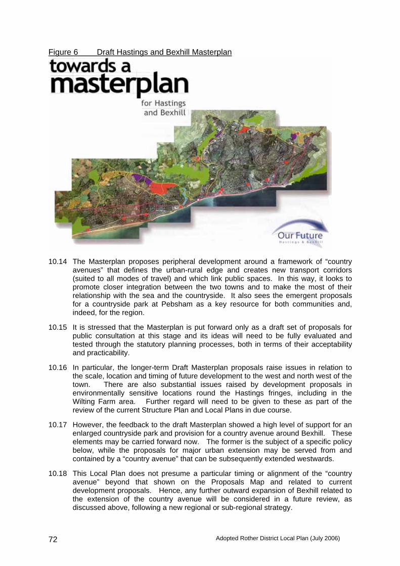
Adopted Rother District Local Plan (July 2006) 72
Figure 6 Draft Hastings and Bexhill Masterplan
10.14 The Masterplan proposes peripheral development around a framework of “country
avenues” that defines the urban-rural edge and creates new transport corridors (suited to all modes of travel) and which link public spaces. In this way, it looks to promote closer integration between the two towns and to make the most of their relationship with the sea and the countryside. It also sees the emergent proposals for a countryside park at Pebsham as a key resource for both communities and, indeed, for the region.
10.15 It is stressed that the Masterplan is put forward only as a draft set of proposals for public consultation at this stage and its ideas will need to be fully evaluated and tested through the statutory planning processes, both in terms of their acceptability and practicability.
10.16 In particular, the longer-term Draft Masterplan proposals raise issues in relation to
the scale, location and timing of future development to the west and north west of the town. There are also substantial issues raised by development proposals in environmentally sensitive locations round the Hastings fringes, including in the Wilting Farm area. Further regard will need to be given to these as part of the review of the current Structure Plan and Local Plans in due course.
10.17 However, the feedback to the draft Masterplan showed a high level of support for an
enlarged countryside park and provision for a country avenue around Bexhill. These elements may be carried forward now. The former is the subject of a specific policy below, while the proposals for major urban extension may be served from and contained by a “country avenue” that can be subsequently extended westwards.
10.18 This Local Plan does not presume a particular timing or alignment of the “country
avenue” beyond that shown on the Proposals Map and related to current development proposals. Hence, any further outward expansion of Bexhill related to the extension of the country avenue will be considered in a future review, as discussed above, following a new regional or sub-regional strategy.

Adopted Rother District Local Plan (July 2006) 73
North-east Bexhill (Inset Map 1a) 10.19 Proposals for north-east Bexhill put forward below provide the basis for sustainable
long-term growth insofar as they plan for:
• the creation of a robust, long-term urban edge, with development contained from the wider countryside setting by well-defined topographical and landscape features
• high quality business sites, with good connections to the urban area as well as to the transport network, which should meet employment and regeneration needs for the foreseeable future
• the creation of new and expanded residential communities, both in the Worsham Farm area and, over time, westward of the Preston Hall Farm area
• establishment of a major countryside park between Bexhill and Hastings that not only serves as a recreational resource for the two towns, but also provides for the long-term management of the strategic gap and the rural fringe all the way round to Sidley
• the first stage of the “country avenue” for movements around the town and to provide access to new employment and housing areas, leisure and recreational facilities and the countryside
10.20 Key factors in determining the location, scale and form of development to be
accommodated in north-east Bexhill are:
- the timing of construction of the Link Road - the ability to generate sufficient additional jobs for growth to be
sustainable - the strength of the local housing market - the need to protect the rural landscape setting of the town - the need to create a community
10.21 The Highways Agency has now indicated that a substantial development cannot be accommodated in terms of current trunk road capacity on the A259 between Bexhill and Hastings. This scheme has now been supported in principle by Government. It has also advised that the scheme qualifies for Government funding. East Sussex County Council, as local highway authority, is developing detailed proposals. Allowing for the necessary consultation and statutory procedures, it is understood that the road could be completed during the first half of 2010. This will limit the amount of development within the Plan period, although there could be potential for completion of some of the Policy BX2 housing should a transport assessment demonstrate an acceptable impact on the main road network.
10.22 Business development must be a priority in the development of north-east Bexhill. If
carefully planned and developed, it can provide the focus for sustainable growth. It is very difficult to estimate the potential job creation over the Plan period. Whilst recognising that all development may not take place by 2011, it is still considered appropriate to plan for some 50,000m2, as originally envisaged in the North Bexhill Strategic Framework, 1993, with the potential for some 1,500 – 2,000 jobs. This recognises the long-term locational advantages that the site will have and the major task of regenerating the wider area. Its development will contribute significantly to the regeneration and workforce needs of the area in the foreseeable future.
10.23 A review of the extent of development should have full regard to landscape and other
environmental factors. Whereas development was previously contained by the proposed bypasses, landscape factors suggest a somewhat different, and lesser, development area, with its outer edge tighter to the urban area at its eastern end.

Adopted Rother District Local Plan (July 2006) 74
10.24 To create a community, as opposed to a residential suburb or estate, requires a certain threshold size to support the provision of services such as a primary school, community and leisure facilities, local shops. For example, a primary school needs a catchment of some 800 houses. Therefore, even if development is not capable of being completed by 2011, it should be comprehensively planned as an entity.
10.25 In order to secure the proper planning of the area, it is concluded that proposals for
major development to the north-east of Bexhill should be planned as a strategic location, with provision for development continuing beyond 2011.
10.26 This will be secured by three complementary land allocations:
(1) Land east of the proposed Link Road, including Glovers Farm and Worsham Farm for a new community and prestige business development;
(2) Land west of the proposed Link Road, including Oaktree Farm and Preston Hall Farm for a major business area with some housing and open space;
(3) Land east of the proposed Link Road beyond the proposed development at (1) above and extending across the gap between Bexhill and Hastings as a countryside park.
These allocations will supersede the proposals contained in the North Bexhill Strategic Framework 1993.
10.27 This approach is seen as the most effective means of securing early job creation in
order for sustainable growth. For economic and land use reasons, it is proposed that the business elements be located closest to the planned Link Road. Creating two distinct housing areas also increases the potential for Bexhill to contribute fully to Structure Plan housing requirements. A North Bexhill Master Plan Supplementary Planning Document will be prepared in consultation with stakeholders, community groups and others. This will give further guidance on the phasing and density of development across the Policy BX2 and BX3 allocations and on the infrastructure contributions necessary to satisfactorily accommodate such a significant development.
Policy BX2 Land north of Pebsham, Bexhill, including Worsham Farm and
Glovers Farm, as defined on the Proposals Map, is allocated for a mix of housing, business and related uses.
Proposals will be permitted where the following criteria are met:
(i) a comprehensive scheme is put forward, embracing both
residential and business elements, to be progressed in parallel and provide for job creation at the earliest opportunity;
(ii) the residential development shall be developed as a new
community around a well-defined neighbourhood centre;
(iii) at least 980 dwellings should be provided, of which 40% shall be affordable;
(iv) some 22,000m2 of business floorspace shall be provided;
(v) the new neighbourhood centre shall include a new one-
form entry primary school, nursery school, community hall, shops and services to meet local day-to-day needs and an amenity/recreation area;

Adopted Rother District Local Plan (July 2006) 75
(vi) no development shall be occupied until the Link Road is constructed and open, unless demonstrated by a Transport Assessment that the impact upon the main road network is acceptable and in accordance with an agreed phasing plan for the overall development of the Policy BX2 and BX3 policy areas, while the actual location of development will have regard to the approved route;
(vii) business development will be of a high quality, with high
specification, prestige buildings in prominent and “landmark” locations, contained within a generous landscape framework;
(viii) employment uses will be either offices, research and
development or light manufacturing, falling within Class B1 of the Use Classes Order;
(ix) the layout and design of the new community shall accord
with the principles laid out in Policy HG4 and incorporate open spaces and play areas in accordance with Policy CF4 in addition to the strategic “green” spaces and corridors and woodland areas shown;
(x) access roads shall be from the proposed Link Road with
two connections from Wrestwood Road, as shown on the Proposals Map, except that any developments which may be permitted to be brought into use before the opening of the Link Road in accordance with criterion (vi) may be permitted to take temporary access from another road but only until a new access has been established to the Link Road and Wrestwood Road as to be provided for in the North Bexhill Master Plan SPD;
(xi) a local distributor road shall form the northern edge of
built development and shall be laid out as a wide “country avenue”, contained to the north by a strong landscape tree belt; this shall incorporate a bus route and segregated cycleway/footway, which connect key destinations within the development and beyond;
(xii) an overall net housing density of not less than 35
dwellings per hectare with a net housing density for each area or sub area within the development of not less than 30 dwellings per hectare with higher densities of not less than 40 dwellings per hectare close to the neighbourhood centre and public transport routes, the extent and minimum density for each sub area to be defined in the North Bexhill Master Plan SPD;
(xiii) land to the north of the “avenue” will be incorporated into
the Countryside Park and remain undeveloped, with the possible exception of land south of Combe Wood where recreational uses may be permitted if subsequently shown to be warranted by a recreational needs assessment;

Adopted Rother District Local Plan (July 2006) 76
(xiv) land at the eastern end of the “avenue” may be reserved for a small car park to serve the Countryside Park;
(xv) development contributions are made towards off-site
improvements to related community facilities, transport and other supporting infrastructure. Development proposals will be subject to a Transport Assessment and Travel Plan, but may relate to high frequency bus services/facilities to Bexhill town centre and north Hastings, pedestrian and cycle links to Sidley, Bexhill town centre and the Countryside Park. Contributions would also be required towards the Countryside Park, recreational provision, library improvements and secondary school provision.
Policy BX3 Land north of Sidley, Bexhill, including Oaktree Farm and Preston Hall Farm, as shown on the Proposals Map, is allocated for major business development, together with housing and open space within a generous landscape setting.
Proposals will be permitted where the following criteria are met:
(i) a comprehensive scheme is put forward, embracing both
residential and business elements, to be progressed in parallel and provide for job creation at the earliest opportunity;
(ii) some 26,000m2 of business floorspace shall be provided.
This will be mostly light manufacturing and offices, falling within Class B1 of the Use Classes Order; Class B2 (general industry) and Class B8 (storage) uses will only be allowed in visually contained locations away from housing;
(iii) at least 130 dwellings shall be developed, of which 40%
shall be affordable, with no sub areas to be developed at less than 30 dwellings per hectare;
(iv) proposals for structural open spaces, landscape and
woodland belts shall be developed and implemented as an integral part of proposals;
(v) the layout and design of the residential development shall
accord with the principles laid out in Policy HG4 and incorporate open spaces and play areas in accordance with Policy CF4 in addition to the strategic “green” spaces and corridors and woodland areas shown;
(vi) there shall be no new dwellings in the vicinity of Preston
Hall to the north of the allocated housing area;
(vii) vehicular access shall be from the Link Road via the Country Avenue local distributor road with a loop road to connect the employment areas to the local distributor road;

Adopted Rother District Local Plan (July 2006) 77
(viii) a local distributor road shall form the northern edge of built development and shall be laid out as a wide “country avenue”, contained to the north by a strong landscape tree belt; this shall incorporate a bus route and segregated cycleway/footway, which connect key destinations within the development and beyond, as indicated diagrammatically on the Proposals Map including the “Green Links” along Buckholt Lane and to Watermill Lane;
(ix) housing development will be accessed by an access road
from the western end of northern avenue, with pedestrian/cycle access only to adjoining residential areas;
(x) development contributions are made towards off-site
improvements to related community facilities, transport and other supporting infrastructure. Development proposals will be subject to a Transport Assessment and Travel Plan, but may relate to high frequency bus services/facilities to Bexhill town centre and north Hastings, pedestrian and cycle links to Sidley, Bexhill town centre and the Countryside Park. Contributions would also be required towards the Countryside Park, recreational provision; library improvements and secondary school provision.
10.28 A new "countryside park" at Pebsham, is proposed between the built-up areas of
Bexhill and St Leonards within Rother District and extending into the Combe Haven valley as shown on the Proposals Map. Part of this land is currently used as a landfill site which is due to cease operation in 2008 and will be restored as part of the Park. Adjacent land is identified in the East Sussex Brighton and Hove Waste Local Plan for a range of waste related facilities, including the existing Reprotech waste derived fuel plant, a materials recovery facility and waste transfer station. That land is therefore excluded from the Policy BX4 allocation, as is the existing nearby wastewater treatment plant. The Countryside Park will be developed for recreational activities and nature conservation alongside continuing agricultural use whilst remaining mainly open. Policy BX4 Land between Bexhill and St. Leonards, from Galley Hill in the
south to the proposed Link Road to the north, as shown on the Proposals Map, is allocated as a Countryside Park.
Within the Countryside Park area, proposals will only be
acceptable where they:
(i) are consistent with the establishment and maintenance of the area as a key recreational and amenity resource for Bexhill and Hastings and their wider catchment; and
(ii) provide for the proper conservation and, where
appropriate, management of the Site of Special Scientific Interest and the Site of Nature Conservation Importance within it; and

Adopted Rother District Local Plan (July 2006) 78
(iii) accord with the proper protection of areas at risk of flooding, in accordance with Policy DS1; or
(iv) are in compliance with other relevant development plan
policies for this site.
A management plan will develop a detailed framework for the layout of the Countryside Park, and will in due course provide a supplementary planning document.
Town centre (Inset Map 1e)
10.29 The Council wants to see the town centre strengthen its position as the commercial and cultural heart of Bexhill. This includes building on its considerable strengths in the mix of land uses and strong architectural character, to support commercial regeneration and to create a more vibrant shopping environment with new retail development and the better integration between key facilities.
10.30 Improved accessibility will be a key to this, and a town centre traffic management
strategy is envisaged. This will assess the scope for reducing the impact of cars in the town centre and improving facilities for buses, taxis and cyclists. Parking may be managed better. This will be prepared in conjunction with the County Council and subject to widespread consultation.
10.31 An allocation of land for a significant retail/mixed use development is set out below.
Other smaller sites may come forward for redevelopment or intensification including those identified in the Council’s Assessment of Urban Housing Capacity. Such sites and premises will be favourably considered for retail use in accordance with Policy EM13, where possible with office or residential uses on upper storeys. In addition, a hotel proposal on a suitable site would be encouraged.
10.32 There is sufficient opportunity in the town centre “main shopping area” to
accommodate the anticipated need for additional retail floorspace up to 2011. This is expected to be achieved by an expansion/redevelopment of Sainsburys and related redevelopment along Western Road (see below), as well as through the expansion of existing space and increased turnover in existing shops. A comprehensive mixed-use development in this location also offers the opportunity to rationalise town centre car parking, better integrate commercial development north and south of the railway and improve access to the station itself. A development brief will be prepared for the Policy BX6 site and shall, amongst other things, include design guidance relating to the development context which includes a designated Conservation Area and the setting of listed buildings. Policy BX5 For the purposes of Policy EM13, the main shopping area of
Bexhill will be that so defined on the Proposals Map, Inset 1e and this will be the primary focus for retail development.
Policy BX6 Within the town centre on the area defined on the Proposals Map
Inset 1e, land including the Sainsbury’s store and other properties on both sides of the railway is allocated for a mixed retail, residential, office and car parking development to include the potential for rafting over the railway itself.

Adopted Rother District Local Plan (July 2006) 79
Comprehensive development proposals will be permitted which incorporate the following elements:
(i) a large store, primarily selling convenience goods; (ii) an intensification of retail, residential and office space;
(iii) a decked car park available for public use;
(iv) new or significantly improved pedestrian access across the
railway to Western Road;
(v) enhancements to the public realm, including Devonshire Square, Town Hall Square and Western Road.
10.33 The majority of Bexhill’s offices are located in the town centre. Offices make a significant contribution to the economic activity of the town and are vital to the mixed use character of the town centre. They are increasingly under pressure from alternative residential uses. In order to retain an effective office concentration in the town centre and avoid its fragmentation and loss, it is considered appropriate to promote their retention within the predominantly office areas around the town centre.
Policy BX7 Within Bexhill town centre in the office areas defined on Inset
Map 1e of the Proposals Map, favourable consideration will be given to office uses on all floors within Use Classes A2 (a) and (b) and Use Class B1(a), subject to the other policies of this Plan. The loss of office uses, through conversion or redevelopment, will only be permitted where it is demonstrated that there is no prospect of a continued office use. Where premises within the office area are not currently in office use, this policy shall not preclude their re-use for other non-office purposes.
Development boundary 10.34 Outside the strategic urban extension area, consideration has been given to the
appropriate definition of the development boundary for Bexhill 10.35 Towards the eastern end of the town is the relatively tranquil and ecologically
sensitive Combe Haven, surrounded by spurs of higher land rising to ridges to the north and south. To the north, these roll into the High Weald AONB. It is considered especially important to maintain the general containment of the built-up area by the Worsham ridgeline and to protect the strategic gap between the built-up areas of Bexhill and Hastings.
10.36 Further west, the land outside the development boundary becomes more enclosed
with distinct field patterns divided by extensive areas of woodland, tree belts and hedgerows. These run into the heavily wooded ridge of High Woods and Whydown, which largely contain the land from the wider AONB countryside to the north.
10.37 Towards the western end of the town, the surrounding countryside is less wooded,
but a gentle pastoral landscape with extensive hedgerows falling away into the exposed, flat and open landscape of the Barnhorn and Hooe Levels. Extensions to the urban area would encroach into this sensitive setting.

Adopted Rother District Local Plan (July 2006) 80
10.38 In addition to landscape factors, the release of relatively small greenfield sites would not be consistent with Government guidance which favours larger urban extensions capable of accommodating a mix of uses and supporting a range of infrastructure and services.
10.39 Consequently, and in accordance with the Structure Plan and the overall
development strategy, the only proposed “greenfield” allocation at Bexhill is that for the new housing and business development at North Bexhill. Elsewhere, development is to be contained by the existing development boundary, save for a minor revision at Old Harrier Kennels, Maple Walk. There are several urban sites where allocations are appropriate, and help maximise the use of “brownfield” land. Former Galley Hill Depot, Ashdown Road (Inset Map 1c)
10.40 This is 1.3 hectares of derelict former railway land being last used as an oil storage
depot but now largely cleared of structures. 10.41 Planning permission has previously been granted for residential development on the
site, most recently in 1999. However, this has now lapsed. It is understood that the permission was not implemented because the Strategic Rail Authority was undertaking a review of freight requirements along the rail corridor. It has recently indicated that it does not intend to pursue the use of this site for that particular purpose.
10.42 In planning terms, the site offers a significant brownfield opportunity. It has direct
access from Ashdown Road, although some improvements are needed. Past activities have been shown to have contaminated the ground and remediation is required prior to development.
10.43 Housing is also constrained by the adjoining railway line and needs to have regard to
the amenities of dwellings in Galley Hill View on the northern boundary. The layout would be determined at the detailed planning application stage, but the position of the site and potential for sea views suggest a higher density of development, which could provide some 48 dwellings.
Policy BX8 Land comprising the former Galley Hill Depot, Ashdown Road, Bexhill, as defined on the Proposals Map, is allocated for housing purposes.
Proposals will be permitted which provide for:
(i) some 48 dwellings, of which 40% are affordable;
(ii) the layout and design accords with the principles in Policy HG4;
(iii) a proper assessment of the contamination is undertaken
by a competent person and appropriate remediation undertaken;
(iv) a satisfactory new junction to Ashdown Road.
(v) Contributions towards secondary school provision.

Adopted Rother District Local Plan (July 2006) 81
High School site and Drill Halls, Down Road (Inset Map 1b) 10.44 East Sussex County Council, as Education Authority, has stated its intention in due
course to relocate the present High School on to a single site at Gunters Lane. While this is a major project for which there is presently no capital commitment, it is considered appropriate now to indicate the alternative land use potentials in the event of such a move.
10.45 The future of the High School site, which amounts to some 3.1 hectares, needs to be
viewed as part of a larger area including the Drill Halls, (half of which is occupied by Services organisations, the other half is empty), King Offa Primary School and the Bexhill Leisure Centre.
10.46 A key factor affecting the whole area is the proposal for a new road along the line of
former railway as a link between Bexhill and north Hastings via Queensway. This will take land on the eastern edge of the High School site as well as residential and commercial properties to the east of the Leisure Centre. This scheme would place the site at a principal junction in the town and provide a gateway to the town centre.
10.47 In such a central and accessible location, it would be appropriate to provide for uses
that generate a significant amount of trips. At the same time, the uses should relate well to The Down and existing land uses in the area. There is also the opportunity to considerably improve the appearance of this prominent site.
10.48 A redevelopment provides the opportunity to improve the provision of leisure and
other community facilities for Bexhill, focussed on the Leisure Centre, as well as a balance of employment and housing. In view of the significance of the site in both location and land use potentials, it is appropriate to allow for further public consideration of detailed proposals.
Policy BX9 Land off Down Road, Bexhill forming the existing High School and Drill Halls, as shown on the Proposals Map, is allocated for mixed-use development comprising offices, community buildings and high density housing, following relocation of the secondary school. The balance and layout of development will be the subject of a Planning Brief.
Land west of Bexhill Cemetery (Inset Map 1f) 10.49 The Council, as Burial Authority, has recently reviewed cemetery provision for the
District. It has resolved that a westward extension to the existing Bexhill Cemetery, is most appropriate to provide for the burial needs of the area. It requires minimal change to the infrastructure in terms of work and pathways.
10.50 It is anticipated that the existing cemetery will be at capacity in certain respects within
the next 2/3 years. The area identified is considered appropriate for the longer term and to accommodate diverse burial requirements. In bringing forward detailed proposals, regard will be had to the proximity of the proposed landfill site and the consequent need for appropriate screening and noise mitigation measures.
Policy BX10 Land to the west of Bexhill Cemetery, as shown on the Proposals
Map, is allocated for cemetery purposes. Proposals should incorporate appropriate landscaping or other mitigation measures.
Adopted Rother District Local Plan (July 2006) 82
11. BATTLE (Inset Map 2)
Context
11.1 Battle is a small historic town of some 6,100 people situated within the High Weald Area of Outstanding Natural Beauty, some 6 miles north of Bexhill and 6 miles north-west of Hastings. It lies on the A2100 approximately 3 miles from the A21 London-Hastings road and Battle station lies on the main Hastings-London Railway.
11.2 The town centre forms the historic core. It consists mainly of the High Street, which
has not been developed in depth. It is dominated by the Abbey, built to acclaim William’s victory in 1066, but also contains many other listed buildings. The area was designated a Conservation Area in 1970. The historic battlefield site, which extends to the south of the Abbey, is a protected heritage site. To the north-east lies National Trust land and other land visually exposed in the countryside.
11.3 The town centre is also the commercial heart of Battle, catering not only for local
residents and those of the surrounding area, but also the many visitors attracted by the town’s heritage.
11.4 Being situated astride one of the principal High Weald east-west ridges, the town has
grown up in a linear fashion. Development has extended over time along this ridge and the spurs, notably that connect to Caldbec Hill and along Marley Lane. The rate of development has been erratic, with greatest growth of 400 dwellings between 1981 and 1991.
11.5 The present pattern of development, having the appearance of a dumbbell when
viewed in plan, means that movement around and across the town is channelled through the centre. As well as local traffic, there is also through traffic on the cross-country A271 and the north-south A2100. Traffic is exaggerated by inadequacies in the A21 and A259 around Hastings and Bexhill. The net effect is regular traffic congestion, as well as harm to the historic character and environment of the town centre.
11.6 It is recognised that a key benefit of proposed improvements to the A21 (see Section
8) will be the removal of inappropriate and unnecessary traffic from Battle. Also, a new parkway station at Wilting Farm (see also Section 8) would take the pressure off Battle railway station.
11.7 Pedestrian links through and around the town are relatively good. However, suitable
routes for cyclists are poor. There is a need for safe cycle routes, particularly between Claverham Community College, the High Street and the larger housing estates.
11.8 For its size, Battle is well provided with a wide range of shops, services and
community facilities. It functions as a service centre for surrounding villages and there is a significant amount of employment provided in the town centre. Elsewhere, the only business/industrial area is near the station, with further employment out of the town along Marley Lane. Employment policies for sites on Marley Lane are to be found in Section 9.
11.9 A further factor in relation to any future development is the capacity of local services,
especially both primary and secondary schools.

Adopted Rother District Local Plan (July 2006) 83
Planning strategy for Battle Policy BT1 Proposals for development and change in Battle should be
compatible with and, wherever practicable, contribute positively to the following objectives:
(i) to maintain its historic, small town character; (ii) to protect the historic core and its setting;
(iii) to conserve the Area of Outstanding Natural Beauty
landscape setting;
(iv) to enhance the commercial and tourism attractiveness of the town centre;
(v) to minimise the demand for cross-town vehicular traffic;
(vi) to maintain a substantial open countryside gap to
Hastings.
11.10 It is necessary to marry these objectives with the requirements for new development and principles for a sustainable distribution of development, as set out in Section 4.
11.11 The location of development should respect the town’s close relationship to landform
and landscape setting. To the south-west, south of Hastings Road, lies the strategic gap between St. Leonards and Battle. If developed, much of the land that surrounds it would severely detract from the fine setting of historic Battle within the attractive landscape of the High Weald, which is designated as an Area of Outstanding Natural Beauty. These are critical factors constraining further growth. Any extension of the ribbon development needs to be resisted, although the development boundary is drawn to include the consolidated built-up frontage along Hastings Road (A2100).
11.12 It is concluded that, notwithstanding the relatively good services and facilities,
because of the topography and other over-riding constraints, the growth potential of the town is fairly limited.
11.13 The Blackfriars area is seen as the principal location for future growth. Land in this
area lying between Marley Lane and Hastings Road has been earmarked for housing development for some 35 years. It is still considered to be the most appropriate location, subject to the inclusion of a new primary school to ensure that it is also sustainable in transport terms, and the retention of large open areas that will create a permanent “green lung” extending into the urban fabric of the town and, hence, provide amenity for the development and the wider area.
11.14 The sensitive redevelopment of the garden centre site and land to the rear in North
Trade Road would enable a predominantly brownfield site to provide additional homes on the west side of the town, but still within the generally built-up area.
11.15 Proposals for these sites are set out below. Elsewhere, the development boundary
for Battle is drawn tightly around its main confines, as shown on Inset Map 2. The policy for the Strategic Gap is to be found at Policy DS5 in Section 4 and is shown on the Proposals Map.

Adopted Rother District Local Plan (July 2006) 84
Land at Blackfriars 11.16 In 1967, East Sussex County Council’s Battle Draft Town Plan notated a part of the
area for residential use and a part for industrial use. In 1972, it published the informal Battle Town Plan and Town Centre Map on which parts of the Blackfriars area were also shown for residential development.
11.17 In 1975, Rother District Council published the Blackfriars Site, Marley Lane, Battle
Design Brief. The brief indicates land for residential development, possible primary school site, possible local community centre, possible children’s home and open space. Both the Consultative Draft (1995) and Initial Deposit (2001) versions of the Rother District Local Plan show land for development within the Plan period and beyond the Plan period. Notwithstanding this background, only a relatively small part of the area has so far been developed.
11.18 Some 90% of the Blackfriars site is bounded by development, with semi Natural
Ancient Woodland bounding the remainder. Any development would need to respect the setting of adjoining Listed Buildings and an attractive group of farm buildings to the north-east.
11.19 Two areas suitable for development are shown on Inset Map 2. The density of
development will be at least 30 dwellings/ha. At least 220 dwellings would be accommodated of which 40% are to be ‘affordable’. A key theme to the development of the area would be to keep the most prominent land, the steepest slopes and the copses free from development for informal public open space. This would provide a very usable ‘green lung’ to the development and help assimilate it within the wider landscape of the High Weald Area of Outstanding Natural Beauty.
11.20 The Education Authority has indicated the need for an additional primary school to
serve the growth of the town, and a new primary school on this site would give a locational balance to provision. It is expected that this will be phased in as development progresses.
11.21 With a development of this size, land will need to be provided for a children’s play
area within or adjacent to the housing allocation and developer contributions sought. 11.22 Bearing in mind the proximity of the site to Battle railway station, the provision of a
pedestrian link across the railway to the station entrance would be a potentially important element of the site’s accessibility and would be more direct and convenient than the present route via Marley Lane and the level crossing. Within the area adjacent to the railway a small element of B1 office-orientated use may be considered in lieu of some of the housing allocation.
11.23 A spine road will link Hastings Road (A2100) with the ‘C’ class road, Marley Lane.
This spine road was envisaged in the ‘Blackfriars Site, Marley Lane, Battle, Design Brief’, and has been constructed in part at both ends. However, a Transport Assessment will be required because of the size of the development and is likely to entail the developer contributing to the improvement of the off-site junction of Lower Lake (A2100) and Marley Lane (C Class Road).
Policy BT2 Land at Blackfriars, Battle, as defined on the Proposals Map, is allocated for housing, education and open space purposes, to be brought forward through a comprehensive scheme.

Adopted Rother District Local Plan (July 2006) 85
Two areas, totalling approximately 7.3 hectares, would be allocated for residential use, providing at least 220 dwellings (40% of which would be affordable). Other land between the two areas for residential development is allocated for a single form entry primary school and to provide a large area of open space. The development will be accessed by a new spine road, from the south from Hastings Road, off The Spinney, and from the north via Harrier Lane off Marley Lane. A Transport Assessment will be required.
Developer contributions will be required towards both primary
and secondary school provision and to provide for a children’s play area on land adjacent to the housing allocation. In addition, developer contributions will be required to secure the provision of the spine road and other accessibility improvements. The pedestrian link across the railway is subject to further detailed examination of its viability and, if necessary, developer contributions for its provision will be required.
Land north of North Trade Road 11.24 Approximately half of the site, lying on the north side of North Trade Road, is currently
in garden/nursery use and the remainder is unmanaged grassland. It is bounded to the west by Frederick Thatcher Place (formerly Battle Hospital) and now a Listed building. To the east, the site is bounded by existing housing development, while to the north lies established woodland. Because of the topography, development would be well hidden from distance views. The former hospital is perceived as the start of the more built up part of the town and, hence, should be defined as the eastern extent of the development boundary for Battle. This site is on the “town side” of the hospital.
11.25 Great care will need to be taken in the design of the development. As well as
protecting the setting of the Listed Building, there is an opportunity to enhance it. It will therefore be necessary for development to be well set back from North Trade Road, as well as keeping a clearance from the former hospital building itself. The land falls away quite sharply to the rear of the site, hence, care will need to be given to the grouping of buildings and provision of vehicular access. The total development area is nearly 0.8 hectares.
11.26 The access would require the provision of a footway along the existing frontage to
connect with the footway that finishes outside Beacon Cottage. It would also require the provision of pedestrian crossing facilities to allow easy access to Claverham Community College. Developer contributions will be required towards both primary and secondary school provision.

Adopted Rother District Local Plan (July 2006) 86
Policy BT3 Land north of North Trade Road, Battle, as shown on the Proposals Map, is allocated for housing. Approximately 30 dwellings would be provided (40% of which to be affordable) with access to the site from North Trade Road. Development should be well set back behind the building line of the former hospital and with a clear separation alongside it. Developer contributions will be required towards both primary and secondary school provision in addition to contributions towards footway improvement and pedestrian crossing facilities.
Town Centre 11.27 It is not considered that there will be a need for significant new retail floorspace over
the Plan period that would warrant a shopping land allocation. Any further retail development is expected to be contained in the ‘main shopping area’, in accordance with Policy EM13. The boundary of the main shopping area is shown on Inset Map No. 2a.
11.28 It is no longer considered appropriate to seek to provide a rear service road to
commercial premises to the west of the High Street or to provide a new vehicular access to Battle Abbey. Visitor numbers should be increased only as far as is compatible with maximising use of the existing car and coach parking facilities and encouraging greater use of public transport.
11.29 The central historic core of Battle, together with the historic battlefield of the
Battle of Hastings forms Battle Conservation Area. Policies in respect of these are found in Section 4 and PPG15, and the Conservation Area is identified on the Proposals Map.

Adopted Rother District Local Plan (July 2006) 87
12. RYE AND RYE HARBOUR (Inset Map 3)
Context 12.1 Rye is a small historic town at the eastern end of Sussex. It is situated at the
confluence of the Rivers Rother, Brede and Tillingham and now lies some 2 miles from the mouth of the River Rother. The population of Rye Town has remained little changed over the past sixty years at some 4,500, but with the contiguous parts of Rye Foreign and Playden, its population rises to over 5,000. Rye Harbour has a further 500 permanent residents.
12.2 The historic core of the town is defined by cliffs and remnants of the town wall. This
area is generally known as the Citadel. It possesses a distinctive outline and is a focal point for many miles around, particularly from Romney Marsh, Rye Harbour and Winchesea. In medieval times on the highest tides Rye became as island. In spite of the recession of the sea, it still presents the appearance of an island rising in places on cliffs above the low-lying country. From some view points, this characteristic is modified to the appearance of a peninsular where it looks as though it projects from a ‘mainland’ on its northern side. In 1971, the historic core of Rye was designated a Conservation Area. Separate consideration is being given to extend it to the west and north.
12.3 For its size, Rye is well provided with a wide range of shops, services and community facilities boosted by high numbers of visitors. It functions as a service centre for surrounding villages, probably serving a population of some 12,500.
12.4 There is not only a significant amount of employment in Rye itself, but also at Harbour
Road between Rye and Rye Harbour. Camber, some 3 miles distant and with some 12,000 tourist bedspaces, provides much seasonal employment.
12.5 Rye sits astride the route of the A259 south coast trunk road. The road is of poor
standard, both to the east and west, and there seems little prospect of significant improvements in the foreseeable future. It also lies on the Hastings – Ashford railway, which gives a poor service in terms of both convenience and comfort. Journeys to London require a change of train at either Ashford or Hastings. However, notwithstanding that the South Coast Multi-Modal Study (2002) recommended the double tracking of the railway between Ashford and Hastings to permit a new half hourly express service between Ashford and Hastings, the Strategic Rail Authority has stated that neither electrification nor dualling of the track are likely to happen in the short or medium term. There is only a prospect of improved comfort, with the introduction of new diesel trains by the end of 2004. The Harbour of Rye and flood defence
12.6 The Harbour of Rye comprises all the tidal channels seaward of the tidal sluices on
the River and its tributaries, the Brede and Tillingham. It is managed by the Environment Agency. Navigation is restricted to high water periods. There are two private cargo handling facilities: one at Rye Wharf, Rye Harbour Village handles mainly roadstone, aggregates and timber, the other, situated further upstream, off Harbour Road handled aggregates. It is currently not in use.

Adopted Rother District Local Plan (July 2006) 88
12.7 The main fishing fleet is moored at Fishmarket, adjacent to Town Salts, Rye, with further fishing boats moored at Admiralty Jetty on the east bank of the River Rother opposite Rye Harbour Village. Yachts are mainly moored between Rock Channel and Strand Quay, where visiting yachts (under 50 feet) are accommodated. Fishmarket is the subject of a current improvement scheme. Slips are available at Rye Harbour, Rock Channel and Strand Quay.
12.8 The Harbour has important flood defence functions by providing outlet tidal channels
for the low lying land of the marshes and for the Rivers Rother, Brede and Tillingham. The Harbour also contains a large number of flood defence assets whose purpose is to prevent tidal inundation. The western tidal walls, which defend 90% of the built up part of Rye, are the subject of an improvement scheme, due for completion in 2008. It is designed to give protection up to the one in two hundred year extreme event. Rye Harbour Village
12.9 Rye Harbour village is located on the southern bank of the river Rother about 1 mile
upstream from the river mouth. Rye lies upstream some 2.5 miles to the north-west. 12.10 There are two public houses, a general store, a repair garage and a church, but no
post office or primary school. The reopening of the Post Office is currently being investigated. A half hourly bus service operates to Rye, except on Sundays. There are moorings and other boating facilities, including a public slip and an RNLI Inshore lifeboat. Access is a problem insofar as Harbour Road has an inadequate junction with the A259 at Rye and there is no footway/cycleway alongside Harbour Road.
Planning Strategy for Rye and Rye Harbour
Policy RY1 Proposals for development and change in Rye should be compatible with and, wherever practicable, contribute positively to the following objectives:-
(i) to maintain the small market town residential and
employment functions together with its character; (ii) to protect the unique historic Citadel and its landscape
setting, particularly the levels surrounding the Citadel;
(iii) to maintain and enhance navigation on the River Rother and the viability of the Port of Rye as a harbour;
(iv) to enhance the commercial and tourism attractiveness of the Citadel and the wider area as far as is compatible with preserving their character and environment;
(v) to promote economic regeneration, including further job
opportunities at the Harbour Road employment area;
(vi) to maintain a strategic gap between Rock Channel and the industrial development at Harbour Road.

Adopted Rother District Local Plan (July 2006) 89
Policy RY2 Proposals for, development and change in Rye Harbour should maintain and enhance its character and amenities as a residential village, boating centre and tourist attraction, with particular emphasis on achieving accessibility and environmental enhancements.
12.11 The location of development should respect the close relationship to landform and
landscape setting. Much of the land that surrounds Rye is within a flood risk area and also, if developed, would severely detract from the setting of Rye. These factors constrain further growth and any extension of the ribbon development and other development on the levels needs to be resisted. The capacity of the town to take significant additional traffic is also limited in environmental as well as physical terms.
12.12 The national and international ecological importance of land surrounding Rye and
Rye Harbour, in particular for wetland habitats, is recognised through a range of specific nature conservation designations.
12.13 Having regard to the planning objectives and development constraints, it is concluded
that, notwithstanding the relatively good services and facilities, the future growth of Rye should remain fairly modest.
12.14 It is especially important to make best use of existing urban land in order to minimise
outward encroachment either on to the levels or into the High Weald Area of Outstanding Natural Beauty, and to protect the setting of the Citadel.
12.15 The opportunity exists for residential redevelopment at the site of the former Thomas
Peacocke Lower School off Ferry Road. This proposal is particularly significant as, with adjacent land in the railway corridor, it opens up the potential for a second access to the Community College, giving some relief to Town Centre roads and encouraging non-car travel. An allocation is put forward below.
12.16 An area east of South Undercliffe, including Slades Meadow and South Undercliffe
allotments also has potential for intensification and redevelopment. Proposals for the redevelopment and renewal of this area, are also put forward below.
12.17 If there is a need to consider development beyond the existing urban limits of the
town, then land to the north of Udimore Road is found to be the most appropriate. It is neither the subject of landscape or nature conservation designations, nor for the greater part, at risk of flooding. Development is also regarded as practicable in other respects.
12.18 However, given the priority to reusing urban land and the policy objective of only
relatively modest growth in Rye, then it is considered that any development here would only be warranted if identified and potential urban sites are not realised and housing supply is consequentially insufficient. Hence, an allocation is put forward below, but development is also the subject of a phasing restriction at Policy DS6 in Section 4.
Land adjacent to Rock Channel 12.19 This land affords the opportunity for development to contribute to the revitalisation of
the town by making effective use of its proximity to the town centre and waterside position, rationalising conflicting land uses and general upgrading of the area. At the same time, it is highly sensitive to change. It forms a key part of the historic setting of the Citadel and is prominent in views to and from the south-east of Rye.

Adopted Rother District Local Plan (July 2006) 90
12.20 It is concluded that the present mix of land uses is inappropriate in such a significant location, while a higher density of development is also achievable which should help regenerate the town as well as lead to environmental improvements. Such improvements should take advantage of the waterside.
12.21 A comprehensive approach to development in this area is required in order to ensure
the most effective and efficient use of land and that individual elements contribute to a holistic vision, which also looks to strengthen links with adjacent areas, notably the town centre. The area is allocated for housing, open space, appropriate commercial uses and offices, falling within the A2 and B1 use classes, which should be at a scale appropriate to this mixed-use site close to the town centre. At this stage, it is recognised that a range of further economic, social and environmental appraisals are necessary in order to test and refine these proposals. A ‘development brief’ is proposed as the most appropriate means of progressing this.
12.22 Provision for affordable housing shall be integral to all residential developments to
comprise 40% of the total number of dwellings, presently estimated to be 55.
Policy RY3 Land between South Undercliff and Rock Channel Rye as defined on the Proposals Map, is allocated for housing, , open space and appropriate commercial uses. Detailed proposals will be formulated through a comprehensive Development Brief. This should provide for:
(i) selective redevelopment that makes efficient and effective
use of the land; (ii) high density housing, including 40% affordable housing;
(iii) commercial uses that complement the town’s tourism and
marine functions together with suitable office uses;
(iv) a riverside walk capable of linking to Strand Quay and the Fishmarket site;
(v) a suitable alternative site for the allotments in the event of
their relocation;
(vi) improved access and parking arrangements, as well as pedestrian links to the town centre;
(vii) the timing of development related to the completion of
planned flood protection works.
Development proposals in this area will only be permitted where they accord with the above principles, form part of comprehensive proposals for its redevelopment and renewal, and be subject to further assessment of their regeneration benefits, environmental and transport implications.

Adopted Rother District Local Plan (July 2006) 91
Former Thomas Peacocke Lower School and adjacent land 12.23 The site has been unused for several years and will be surplus to East Sussex
County Council’s educational requirements if its preferred location for a replacement Primary School for Rye on an adjacent site is duly approved. However, if that is not secured, this site may still be considered for educational use and it would be prudent to provide for this possibility. It is situated within the flood risk area, but on completion of the Rye Tidal Walls and Embankments (Western Bank) scheme, the site can then be considered for development in accordance with Government guidance.
12.24 It is considered that the site is suitable for residential use and, being close to the town
centre, is suited to higher density housing. Some 32 dwellings could be accommodated, 40% of which would be ‘affordable’ in accordance with Policy HG1.
12.25 The future of the adjacent railway corridor on the north side of the railway between
Ferry Road and the Community College, Sports Centre and the swimming pool needs to be considered at the same time, as they are currently only accessed from the west via Rye town centre and Ferry Road level crossing. Although the character of the railway corridor ought to remain essentially ‘green’, it is proposed that a multi-use vehicular link to these community facilities from Ferry Road should be constructed. Such a link would reduce traffic along Station Approach, Cinque Ports Street and Rope Walk, as well as avoiding the need to use two level crossings, and support the provision of high quality pedestrian and cycling facilities.
12.26 As regards access into this site, the best option, in terms of the Highway Authority’s
requirements, is a signalised junction. The junction should incorporate phasing for the level crossing, access into the site, and the fire station. It had been envisaged that the Queen Adelaide Public House would need to be demolished to create a suitable access, but it is now considered that demolition may not be necessary. Policy RY4 Subject to the site no longer being required for educational use,
some 0.8 hectares of land on the site of the former Thomas Peacocke Lower School, Rye is allocated for housing development. Access shall be from Ferry Road and development should also provide for a new vehicular, cycle and pedestrian link to the community College, Sports Centre and swimming pool. The site is suitable for at least 32 dwellings of which 40% are to be affordable. The development should involve the necessary junction improvements to provide access and developer contributions will be required for off-site works to create the above access link.

Adopted Rother District Local Plan (July 2006) 92
Land north of Udimore Road 12.27 This is the only ‘greenfield’ site in Rye that is not the subject of any nature
conservation designations nor is it within the High Weald Area of Outstanding Natural Beauty. Only a small part close to the northern boundary is within the flood risk area and this part could be put to recreational use or kept as informal open space.
12.28 The site is not unduly visible in the landscape, but care should be taken to mask ridge
lines on the higher ground by sufficient tree planting along the north western boundary. It is estimated that at least 114 houses would be provided, although the exact extent of development would be determined following a full landscape assessment. A policy requirement would be that 40% of the dwellings are affordable.
12.29 Access to the site would be from a point beyond the outermost property on the north-
west side of Udimore Road, via a mini-roundabout. Not only would this provide safe turning facilities for vehicles wishing to access the site, but could also act as traffic a calming measure at the entrance to the town.
12.30 There is already a link for pedestrians to walk towards the station and town centre.
Therefore, any developer would be expected to contribute to improving the existing pedestrian facilities into the town centre. This will include crossing facilities on pedestrian ‘desire lines’. Developer contributions will be also be required towards the proposed access from Ferry Road to the Thomas Peacocke Community College Sports Hall and swimming pool.
12.31 However, as discussed at paragraph 12.17 above, the release of this site is subject to
Policy DS6 in Section 4.
Policy RY5 Some 3.8 hectares of land north of Udimore Road, Rye is allocated for housing development. Access would be from Udimore Road opposite Cadborough Farm. The site is suitable for a minimum of 114 dwellings to be developed at a density of at least 30 dwellings per hectare, of which 40% are to be affordable. Developer contributions will be required towards improving existing pedestrian facilities into the town centre, including crossing facilities on ‘pedestrian desire lines’. Developer contributions will also be required for the new vehicular access (mini-roundabout) to Udimore Road, as well as the proposed access from Ferry Road to the Thomas Peacocke Community College, Sports Hall and swimming pool.
Town Centre
12.32 The town centre is focussed on the historic Citadel, extending northward towards the
railway station. In line with Policy EM13 in Section 9, the Council seeks to maintain and, where appropriate, strengthen the role of the town centre. Retail activity should be concentrated within the established main shopping area, which has been extended to include the market site and adjoining shopping developments.
12.33 In accordance with Policy SH2 of the Structure Plan and guidance in PPS6, the retail
floor space needs of Rye are to be assessed, in conjunction with relevant stakeholders and the community. The assessment will take into account the forecast modest growth of the town; the need to counter the leakage of retail expenditure to other centres and the importance of Rye effectively fulfilling its strategically defined role as a residential, local shopping and employment centre and its functions as a key service and major tourist centre. Although no site-specific allocation for further floor space provision is made at this time, the assessment process will be subject to

Adopted Rother District Local Plan (July 2006) 93
regular monitoring and review. Any proposal in the interim would be considered against the provisions of Policy EM13 and, if necessary, the sequential test in Policy EM14.
Policy RY6 The ‘main shopping area’ of Rye, as defined on the Proposals
Map, will be the primary focus for retail development for the town. In the event of the assessment demonstrating a need for significant new convenience floor space growth, the potential to accommodate this will be examined, first of all within the main shopping area and will be fully assessed in accordance with the provisions of Policy EM13 and, secondly, against the sequential tests set out in Policy EM14.
Rye Harbour Road Employment Area 12.34 Rye Harbour Road contains a long-established concentration of industrial uses.
While some uses still relate to its wharf-side and aggregates origins, the area now accommodates a broad range of businesses and provides the main industrial area serving the eastern part of the District.
12.35 Several sites have remained unused for some time, although there has been a recent
upsurge in interest, with new permissions being sought and granted on several sites. Vacant sites without planning permission at April 2003 are shown in Table 7 below.
Table 7: Vacant sites without planning permission, Harbour Road, Rye
Site Ref:
Site Gross Area (ha)
Estimated Net Floorspace* (m2)
1. Castle Water, Harbour Road 0.8 2,800 2. Rear of Long Product Site,
Harbour Road 1.9 6,650
3. Spun Concrete, Harbour Road 6.6 16,000 4. Land east of Bourne’s,
Harbour Road 0.3 1,184
Total Harbour Road 7.9 26,634 * a 35% floorspace:site ratio is assumed for each site. 12.36 These sites, together with those with unimplemented consents, represent a significant
potential for further job creation. Proposals will, where appropriate, be subject to improvements to the Harbour Road/A259 junction and implementation of the Tidal Walls/Embankments flood alleviation scheme. Also, in view of past industrial activities in the area, the relevant Authorities will also need to be satisfied that proper regard is given to the implications for potential contamination.
12.37 Further development should also help facilitate improved accessibility to Rye for
pedestrians and cyclists, which would also support the Rye Harbour village strategy, and may, depending on its nature, also need upgraded sewage treatment facilities.
Policy RY7 Within the Rye Harbour Road Policy Area, as defined on the Proposals Map, proposals for business development (Use Classes B1-B8) will be permitted where the following criteria are met:

Adopted Rother District Local Plan (July 2006) 94
(i) proposals which result in a significant increase in vehicle,
especially HGV, movements will only be permitted when an improvement to the junction of Rye Harbour Road and the A259 has been secured and any consent tied to its construction;
(ii) appropriate financial contributions are made to the
provision of a footway and cycleway along Rye Harbour Road;
(iii) it is demonstrated that proper account has been taken of
any contamination by a competent person, including in its provisions for surface water drainage;
(iv) there is no adverse impact on the adjacent sites of national
and international nature conservation importance, as defined on the Proposals Map;
(v) development shall not commence until measures to
alleviate the potential risk from flooding have been put in place.
Land Adjacent Stonework Cottages, Harbour Road, Rye Harbour
12.38 The site is situated on Harbour Road within the existing development boundary for Rye Harbour village and adjacent to existing residential development. It is currently in low-key employment use and some of the land is unused or used for the storage of old motor vehicles. It has a generally unkempt appearance. The existing employment use could be relocated within the Harbour Road employment area.
12.39 A residential redevelopment in this location is considered a more appropriate use
within the village and could help improve the setting of the Old School House and the children’s recreation ground. The site has an area of 0.52 hectares and is considered suitable to accommodate at least 16 dwellings, 40% of which are to be affordable.
12.40 Although a ‘brownfield’ site, it is also subject to completion of the Rye Tidal Walls and
Embankments (western bank) (expected completion date 2007) to provide adequate protection to enable a residential redevelopment to be considered.
Policy RY8 Land adjacent to Stonework Cottages, Harbour Road, Rye
Harbour is allocated for housing development. Access would be from Oyster Creek. The site has an area of 0.52 hectares and is considered suitable to accommodate at least 16 dwellings, 40% of which are to be affordable. Developer contributions will be required towards improvements of the Harbour Road/A259 junction and the provision of a footway/cycleway along Harbour Road.

Adopted Rother District Local Plan (July 2006) 95
13. VILLAGES
13.1 Villages are a key component of the pattern of development in Rother District. To varying degrees, they face issues of the lack of affordable housing for local people, pressure on local services, sometimes leading to their loss, and limited accessibility, including to job opportunities.
13.2 The Council fully recognises these issues and the policies it puts forward in this Plan for
affordable housing in Section 6, for community facilities in Section 7 and employment and shopping in Section 9 are designed to help address them.
13.3 The general approach to development in villages forms part of the overall spatial strategy
developed in Section 4 and by Policy DS2 specifically. 13.4 An appraisal of all villages has been undertaken as part of the preparation of this Plan in
order to establish the appropriateness of existing development boundaries and the potential for additional development. This had full regard to national planning policy guidance as well as the considerations for determining the scale and nature of change in villages contained in Structure Plan Policy S8, together with the additional factors in Policy S9.
13.5 As a result of that appraisal, several relatively modest allocations are put forward for
housing, two being part of mixed use proposals. In total, these provide for some 188 additional dwellings, equivalent to 15% of the total number of dwellings on housing allocations in the Plan.
13.6 Aside from Rye Harbour, considered in the previous section, the villages where
development allocations are made are: Burwash, Fairlight Cove, Flimwell, Northiam, Robertsbridge, Etchingham, and Westfield. The allocations are elaborated upon below.
13.7 Some development is also anticipated within the development boundaries of other
villages. In fact, a further 26 villages have defined development boundaries as shown in Policy DS3 in Section 4. However, developments in these will be generally quite small scale. This does not preclude the possibility of occasional larger proposals where they meet general development criteria, notably at Policy GD1.
13.8 All housing allocations, as well as residential developments of windfall sites, will also
need to comply with Policy HG4 and other relevant policies. 13.9 As indicated in Section 4, the Plan’s provisions will mean that the overall amount of
development in villages over the Plan period will be notably less than has been the case in the past, while a greater proportion of this will be targeted at meeting local needs.

Adopted Rother District Local Plan (July 2006) 96
Burwash (Inset Map 8)
Land off Strand Meadow 13.10 The site allocated for residential use is relatively hidden from the wider landscape,
nestling on the side of a narrow valley that runs in a northerly direction from the main ridge upon which the village stands. The land is on a steep gradient, which slopes down to a ghyll on its northern boundary, and it is the lower part of the land that is considered suitable for development. The steep slope and most elevated part of the site on its south-eastern side are relatively exposed and should remain undeveloped. This land will be landscaped and planted with appropriate native species in conjunction with the residential development to screen the development and to soften the horizon of the new and existing development. The total area of the allocated land is some 1.7 hectares of which 0.6 hectares would be for housing to be laid out along one side of an access road.
13.11 Access to the site will be gained via Strand Meadow. It will be necessary to look at
rationalising parking along the road and improve the appearance of the highway. Due to the existing number of dwellings that the road currently serves, the Highway Authority recommend that no more than 17 dwellings should be built on the site.
13.12 Adjacent land north of the existing recreation ground has been allocated for recreational
and amenity space. There is an identified shortfall of open play space within the village and therefore the use of this land for recreational use adjacent to the existing play space in the village is sought. There should be local consultation on how it should be laid out. A footpath linking the development with Strand Meadow, the existing recreation ground and Ham Lane will ensure that the recreation facilities are more readily accessible to the development and a larger proportion of the community.
Policy VL1 Land south west of Strand Meadow, Burwash, as shown on the Proposals Map, is allocated for housing and recreational purposes. Proposals will be permitted where:-
(i) no more than 17 dwellings are provided, of which 40% are
affordable; (ii) an appropriate planting scheme is carried out at the time of
the development to landscape the land between the new housing and dwellings in Rother View;
(iii) a footpath is provided to link the new development to the
existing recreation ground and Ham Lane;
(iv) land set aside for recreational purposes is appropriately laid out and provision made for its subsequent management and public access;
(v) both residential and amenity/community uses are progressed
in tandem;
(vi) developer contributions are made to provide for highway improvements in Strand Meadow to improve access conditions.

Adopted Rother District Local Plan (July 2006) 97
Etchingham (Inset Map 13) Land north-west of Etchingham
13.13 The Education Authority advises that the existing school, which lies outside the immediate confines of the village at Burgh Hill, is a priority school for replacement, and that the existing school site is not suitable principally due to the size constraints of the site.
13.14 Also, the existing village hall is substandard both in construction and size, built of pre-
fabricated materials and having been in existence since the beginning of the last century. The Parish Council is looking to replace this, as well as to provide further recreation facilities. The village is recognised as falling well short of the National Playing Fields Association (NPFA) minimum standards.
13.15 The "Lambing Field" has been identified as being most appropriate to accommodate a mixed form of development comprising a new school, village hall, some recreational facilities and an element of residential development to enable the community uses to come forward on the site and to contribute to the need for affordable housing. The adjacent field to the east, known as the former "cricket field" is suited for playing fields.
13.16 The northern parts of the land, which are more elevated and exposed, should be kept free of buildings.
13.17 The south eastern part of the site could satisfactorily accommodate the school and village hall in a combined building and, to the south west, there is sufficient land for at least 15 new dwellings, 40% of which would be affordable.
13.18 It is proposed that, as the extension to the village is justified by the need for community facilities and to enable the recreational facilities and village hall to come forward, the housing element should be tied to the community facilities proceeding.
13.19 The whole scheme will be required to be implemented to reinforce the landscape framework changes to the village and provide screening and containment to development. New areas and belts of woodland, possibly a "community woodland", should form part of these proposals.
Policy VL2 Land north of the A265 on the west side of Etchingham, as shown on the Proposals Map, is allocated for primary school, village hall, recreation and housing purposes.
Proposals will be permitted where:-
(i) a comprehensive mixed-use scheme is put forward embracing
all the above elements;
(ii) provision is made for the land for community facilities to be secured and constructed as part of the development, to be set out in a legal agreement, and shall include provision that the community facilities are provided in parallel with the housing

Adopted Rother District Local Plan (July 2006) 98
development, or as otherwise agreed by the Local Planning Authority;
(iii) at least 15 dwellings-are provided at the south-west of the
site, as shown on the Proposals Map, of which 40% are affordable;
(iv) structural landscape proposals, including woodland, street
belts and open spaces are brought forward and implemented as an integral part of proposals;
(v) a new joint access Is provided off the A265, improved access
arrangements for pedestrians into Etchingham are secured and an appropriate traffic calming scheme on the A265 in the vicinity of the site is implemented.
Fairlight Cove (Inset Map 14) 13.20 The approach to Fairlight Cove is by a C Class road which is generally narrow with tight
bends, steep gradients and poor visibility in places. Within the village, most roads have been made up but several are unmade, narrow and in a poor state of repair. In line with general development policies, where sites are served by substandard or unadopted roads proposals may be subject to requirements to bring them up to adoptable standards or otherwise achieve appropriate highway improvements.
13.21 Close to the cliff edge at Fairlight Cove the land is likely to be affected by erosion or land
instability. Where this is likely to occur during the lifetime of the building a precautionary policy is necessary. Following an analysis of extensive technical work carried out in 2005, the Council now has a better understanding of the cliff failure mechanism in the Rockmead Road area. It is now possible to make a more reliable prognosis of the likely future recession of the cliff. A plan will be drawn up to show the area likely to be affected and this will be available to the public. This plan, which will be updated as necessary, will be used to inform planning decisions.
13.22 It is sensible to avoid putting further development at risk in such areas, while engineering
works are likely to be either prohibitively expensive or have a harmful effect on the character and appearance of the coastline. Therefore, planning decisions in this locality will have regard to potential erosion or land instability in accordance with Government guidance in PPG14: Development on Unstable Land and PPG20: Coastal Planning.
Land adjacent to Fairlight Gardens
13.23 Despite the constraints on major growth at Fairlight, there are a good range of services
and facilities, and the potential for new development on a vacant site in the heart of the village. This land of 0.5 hectares was previously a garden nursery. It is presently unused and overgrown and is bounded on all sides by existing residential development. It slopes towards Lower Waites Lane and relates more to the residential development there, than to the built form of Fairlight Gardens. Compatible medium density housing is therefore proposed. On this basis, the site would accommodate at least 15 dwellings.

Adopted Rother District Local Plan (July 2006) 99
13.24 Access should be taken from Lower Waites Lane with the approach along Smuggler’s Way, subject to widening the junction with Lower Waites Lane, as well as upgrading the approach to an adoptable standard. A strip at Limehurst needed to improve the width and alignment of the existing highway has already been dedicated for this purpose.
13.25 Sewerage improvements to provide capacity may be carried out by Southern Water. In
the absence of these improvements, it would be necessary to requisition off-site sewerage to serve the development.
Policy VL3 Land adjacent to Fairlight Gardens, Fairlight Cove, as shown on the Proposals Map, is allocated for housing purposes. Proposals will be permitted where:-
(i) at least 15 dwellings are provided, of which 40% are
affordable; (ii) developer contributions are made for widening the junction of
Lower Waites Lane with Smugglers Way and for the upgrading of Smugglers Way, and towards off-site drainage improvements to accommodate the development.
(iii) no development will be occupied until the 275m rock armour
revetment at the toe of the cliffs adjacent to Rockmead Road has been constructed, together with the associated re-profiling and draining of the existing landslip slope and the installation of a line of pumped wells at the cliff top.
(iv) developer contributions are made to the construction of the
village hall.
Flimwell (Inset Map 15) Land at Corner Farm 13.26 This site comprises the area of former farm buildings and a pre-fabricated building, which
until recently was used as an office, and land to the rear which is open but previously levelled for use as a nursery.
13.27 The allocation of this land for a village hall will ensure this facility is centrally placed
within the village and, therefore, within walking distance for the majority of the community for which it will serve.
13.28 The site is in a prominent location, being at the junction of the A21 with the A268, as well
as being located on a ridge with outstanding rural views to the south. The siting and design of buildings must have regard to the sensitive character of the site and its relationship with the surrounding countryside. The careful juxtaposition of the village hall and housing should minimise the potential for conflict. It is considered that the more level upper area is better suited to the siting of a large community building, ancillary open

Adopted Rother District Local Plan (July 2006) 100
space and car parking, and that to site the hall there in a prominent position would create a suitable focus for the village whilst allowing users of the facility to benefit from the extensive views. The Inset Map allocates this part of the site for community use accordingly. The lower level is suited to housing, although the developable area is somewhat limited by surrounding steep banks. The housing development will contribute to the need for the village hall and thus will be expected to contribute to the construction costs. Policy VL4 Land at Corner Farm, Flimwell, as shown on the Proposals Map, is
allocated for a village hall, housing and open space purposes. Proposals will be permitted where:- (i) a comprehensive scheme provides for the construction of the
village hall no later than the housing development; (ii) at least 12 dwellings are provided of which 40% are
affordable;
(iii) an area of open space/amenity land be included within a scheme to serve the village hall and to maintain public views to the south.
(iv) developer contributions are made to the construction of the
village hall. Land at Old Wardsdown
13.29 The land allocated for residential development is a level site, amounting to 0.3 hectares
and is bounded on three sides by existing residential development. Part of the site comprises brownfield land currently used for garaging and parking, and the remaining land is a greenfield site. Old Wardsdown to the east comprises a recent development of detached and semi-detached houses, built on the site of a former nursery. North of the site is a further 0.25 hectares currently part of the same curtilage, which has not been allocated for residential development, as it is proposed that this land be retained as informal open space to enhance the existing open space provision due east of the site, and to keep development away from the ridge end where the land falls away to the north. It is estimated that the area could accommodate at least 9 dwellings. Developer contributions will be sought towards the construction of the new village hall, whether this occurs before or after housing development.
Policy VL5 Land on the west of Old Wardsdown, Flimwell, as shown on the Proposals Map, is allocated for housing purposes. Proposals will be permitted where:-
(i) at least 9 dwellings are provided of which 40% are affordable; (ii) land to the north is landscaped to strengthen the existing tree
belt at the same time as development and dedicated as informal open space;

Adopted Rother District Local Plan (July 2006) 101
(iii) access is taken from Old Wardsdown;
(iv) developer contributions are made towards a new village hall.
Northiam (Inset Map 26)
Land south of The Paddock 13.30 The land relates well to the existing built form of the village on its northern and western
boundaries and is screened from the countryside to the south and east by natural vegetation along the field boundary in the form of ghyll woodland and ancient woodland. The small stream that runs along the south-eastern boundary is seen as a natural edge to the form of the development in this part of the village, as the land to the south is exposed to the countryside and is rural in character. The land could yield at least 30 dwellings, a percentage of which would be affordable in accordance with the affordable housing policy.
13.31 Vehicular access to the site will be via Goddens Gill and The Paddock on the northern
boundary of the site. This is acceptable in highway terms subject to the improvement of parking provision which currently partially obstructs the highway. In line with the requirements of Policy TR2, a pedestrian link through the development to connect with Beales Lane would help to secure a sustainable access to the services and facilities in the village. This matter will be further investigated at the planning application stage.
13.32 The design and layout of the proposed development would need to have special regard
to the proximity of ancient woodland, adjacent residential properties, the village hall and associated open space. Policy VL6 Land east of the village hall, Northiam, as shown on the Proposals
Map, is allocated for housing. Proposals will be permitted where:- (i) at least 30 dwellings are provided, of which 40% are
affordable;
(ii) development shall be laid out to retain a buffer to the Ancient Woodland to the east of the site;
(iii) access shall be via The Paddock, subject to any necessary
improvements including alternative parking provision to reduce obstruction from on-street parking.
Robertsbridge (Inset Map 30)
Land at Grove Farm, off George Hill 13.33 Robertsbridge is considered suitable for modest growth and a part of Grove Farm,
situated between the historic centre and the A21 Bypass, is considered to be the most

Adopted Rother District Local Plan (July 2006) 102
appropriate site to receive development. Development in this location is also more easily capable of being assimilated into the village than other sites.
13.34 Housing on the allocated land would have little effect on the character of the Area of
Outstanding Natural Beauty or Robertsbridge because of the topography. The site is not within a flood risk area, although care must be taken to ensure that development does not increase risk in the catchment. The site abuts the Conservation Area and part lies within an area of archaeological interest and also appears in the Sites and Monuments Record (SMR) as a Medieval Village. As a consequence, a field evaluation will be required before any decision on a planning application is taken: (Structure Plan policies EN22-EN25 refer-See Appendix 3).
13.35 The site comprises that part of Grove Farm on the western side of the A21 bypass, the
remainder having been severed by construction of the bypass. Most of the land is used for grazing and there is a group of farm buildings, though none of them is listed.
13.36 The housing allocation is limited to the lower slope closest to George Hill. Because of its
prominence in the landscape, that part of the site on the higher ground to the east and south will be kept free of development.
13.37 The eastern boundary, where it abuts the bypass is likely to be visible though not
prominent in the landscape. Care will need to be taken in the siting of new dwellings. Also, development will need to be contained by strengthening the existing tree planting alongside the Bypass. Because the bypass is in a cutting at this point and with the existing planting on the bank and additional planting within the site, any noise from the A21 is likely to be limited.
13.38 The southern end of the site rises considerably, is visually exposed and reads more as
part of the countryside setting of the village. The northern part of the site which fronts Fair Lane should be kept essentially open to maintain the rural setting to Fair Lane and the school.
13.39 In terms of access to the site, the scale of development will require a single access point
on to George Hill. High quality access to the school and community facilities in the centre of Robertsbridge for pedestrians and cyclists will also need to be provided. These facilities need to be extended to allow access to Robertsbridge Train Station. This provision would minimise the impact of the private car on the existing road network of Robertsbridge.
13.40 A survey of the farm buildings on site should be undertaken to establish if any are worthy
of retention. With a development of this size, land will need to be provided for a childrens play area adjacent to the housing allocation and developer contributions sought. While the form of development will be subject to subsequent detailed consideration, there is a strong case for the inclusion of housing for the elderly within the development.
13.41 In view of the site’s greenfield status and location within the AONB, the release of this
site is subject to Policy DS6. Its release would be triggered only if the Plan Monitor Manage process set out in Section 4 demonstrated that the housing needs of Robertsbridge and its surrounding area in the AONB would not be met by the Mill Site or by other development on previously developed land.

Adopted Rother District Local Plan (July 2006) 103
Policy VL7 Land at Grove Farm, Robertsbridge, as shown on the Proposals Map,
is allocated for housing development. The development land amounts to some 0.9 hectares. Access would be from George Hill. Proposals will be permitted where:-
(i) at least 30 dwellings are provided to include housing for the
elderly with 40% of the dwellings to be ‘affordable’. (ii) access is provided to George Hill, together with developer
contributions, improved access arrangements for pedestrians and cyclists to Robertsbridge Station;
(iii) developer contributions are made to provide for a childrens
play area on land adjacent to the housing allocation;
(iv) developer contributions are made towards educational needs at Robertsbridge Community College;
(v) field investigations, in respect of the area of archaeological
interest, are undertaken before planning permission is granted;
(vi) a planting scheme to provide a tree belt 30 metres in width
immediately to the east of the housing allocation and children’s play area, as indicated on Inset Map 30, is carried out at the time of the development to provide screening on the higher land between the housing and the Robertsbridge bypass.
Land to the rear of Culverwells, Station Road 13.42 Earlier versions of the Plan put forward business use on land adjacent to Culverwells, off
Station Road. The proposal has not been implemented. The site has only a gentle slope with a total area of some 2.0 hectares. Access would be through Culverwells site.
13.43 To the south-east lies a factory, to the south allotments, to the south-west Culverwells
Garage, to the north-west the railway and to the north and east the flood plain of the River Rother and Glottenham Stream. Although a ‘greenfield’ site, because of its location, development would relate relatively well to the adjacent railway station, other employment uses and the allotments.
13.44 The site is considered to be the most suitable site for employment use in the village and
a mixed use development of the site is appropriate. The purpose of the mixed use allocation is for a limited amount of residential development to take place to enable employment use development on the remainder of the site. It would be necessary for the development of the two uses to be tied by means of a Section 106 Agreement, to ensure that the employment use development takes place, when the housing development is implemented. It is estimated that some 1,300 square metres of business floorspace could be accommodated, supported by 14 dwellings, of which 40% would be affordable.

Adopted Rother District Local Plan (July 2006) 104
13.45 A part of the site to the north-east is within the fluvial flood risk area. The Robertsbridge
improved flood walls and embankments scheme is due for completion shortly and will provide protection against the 1 in 100 year extreme event. A part of the embankment is within the site and a small part of the site towards the north and east boundaries will remain without adequate protection from the risk of flooding. The development must not interfere with the flood protection works. It will need to be demonstrated that there will be no loss of flood storage nor obstruction of flood flows. A flood risk assessment will be necessary and this could result in a reduction of the developable area.
Policy VL8 Land adjacent to Culverwells, Robertsbridge, as shown on the
Proposals Map, is allocated as a mixed use development consisting mainly of employment use, but with an enabling element of housing development. Proposals will be permitted where:- (i) at least 14 dwellings are provided, at a density of not less
than 30 dwellings per hectare with 40% as affordable dwellings together with at least 1,300 square metres of business floorspace.
(ii) both residential and business uses are progressed in tandem; (iii) a flood risk assessment has been undertaken; (iv) developer contributions are made towards secondary level
education, for Robertsbridge Community College; (v) a suitable access has been provided to Station Road.
Westfield (Inset Map 36) Land off Moor Lane, north of Moor Farm 13.46 On the western side of the village is an area of scrubland that is roughly triangular
shaped and includes an area of hardstanding used until recently for parking coaches, and a pair of derelict cottages. The land, which amounts to 0.7 hectares, has frontages to Moor Lane and Stonestile Lane. The original alignment of the bypass passed through the northern part of this site. The land slopes down to the north and relates well to the existing built form of the village. In view of this, development would not adversely impact on the wider countryside to the south. A public footpath forms a boundary to the settlement on the south side. Access to the site is viable from Moor Lane.
Policy VL9 Land off Moor Lane, Westfield, as shown on the Proposals Map, is allocated for housing purposes. Proposals will be permitted where:-
(i) at least 15 dwellings are provided, of which 40% are
affordable;

Adopted Rother District Local Plan (July 2006) 105
(ii) footpath link is provided along the western side of the site;
(iii) the tree belt hedgerow on the southern boundary is
strengthened.
Wheel Farm Business Park
13.47 Wheel Farm Business Park is on a low-lying level site west of the village. Immediately to the west are three recently constructed units and to the south the older style sheds and barns are occupied by a small number of companies. The inclusion of this site for B1 use is a logical rounding off of the site, and will provide local employment opportunities for the community, which is in alignment with the policies put forward in the employment chapter. It may provide some 1,000m2 of the business accommodation.
Policy VL10 Some 0.3 hectares of land adjoining Wheel Farm Business Park, Westfield, as shown on the Proposals Map, is allocated for business purposes.
Land at Westfield Down
13.48 This is rising ground extending out of the village on the east side of the A28. While the
higher ground is considered to be more sensitive to building development, the lower land would be visually contained in terms of wider views across the Area of Outstanding Natural Beauty and is relatively close to local facilities.
13.49 The northern part of the site could satisfactorily accommodate sports and recreational
uses, for which there is a recognised need within the villages, particularly for football. Because of the sloping nature of the land, some regrading would be necessary, while screen planting would also help minimise its impact.
13.50 As there is no physical division within the site, and because of the need for recreational
facilities to serve the community, it is envisaged that the housing development and recreational element proceed in tandem.
Policy VL11 Land at Westfield Down, Westfield, as shown on the Proposals Map, is allocated for housing and recreation purposes. Proposals will be permitted where:-
(i) comprehensive proposals for both housing and recreational
elements are put forward and the recreational land is secured; (ii) at least 22 dwellings are provided at the southern end of the
site, of which 40% are affordable;
(iii) screen tree planting is provided on the northern boundary;
(iv) a new joint access is provided off the A28 or alternatively via an upgraded existing access to the Surgery.

Adopted Rother District Local Plan (July 2006) 106
Winchelsea Beach (Inset Map 41)
Land at Victoria Way and south of Harbour Farm 13.51 The land at Victoria Way was laid out between the two world wars and is in multi-
ownerships. The area comprises a mix of holiday caravans, dwelling houses and a few unused plots. It is served by mains drainage, water and electricity but access is substandard in terms of width, alignment and surfacing. In addition, there are problems of surface water drainage.
13.52 The land south of Harbour Farm has similar characteristics to Victoria Way although
more plots are unused. All road improvements to be undertaken with any new development must comply with the requirements of the Highway Authority. The widening or improvement to Uncles Lane to improve access will not be permitted as the junction with Sea Road is too close to the junction of Dogs Hill Road and Sea Road. Access could be gained off Sea Road by the appropriate demolition of property, together with land for any visibility splays, etc.
13.53 The following policy seeks to ensure that a comprehensive approach to further
development is taken in view of these constraints regarding access and surface water disposal, and that no significant redevelopment is otherwise permitted on individual plots.
Policy VL12 New dwellings or the placing of additional caravans on existing sites
at Victoria Way and land south of Harbour Farm, Winchelsea Beach as shown on the Proposals Map will be permitted provided such development forms part of a comprehensive scheme offering significant environmental improvements including an orderly improvement of access and drainage to an appropriate standard.
The replacement of an existing dwelling will be permitted on a one-for-one basis, subject to the normal criteria relating to siting, design, external appearance, landscaping and means of access.
13.54 Proposals on land at The Ridge and Morlais Ridge, which were subject to an earlier
policy restricting development to “one-for-one” replacement dwellings, will be considered against general Plan policies for development in the countryside.

Adopted Rother District Local Plan (July 2006) 107
14. HASTINGS FRINGES 14.1 There are several fringe areas of Hastings that lie beyond the Borough boundary and
within Rother District Council’s administrative area. In planning for these areas, due regard is paid to the provisions for adjoining land in Hastings as contained in the Hastings Borough Local Plan Revised Deposit Draft (December 2000) and the Inspector’s recommendations thereon in his report (June 2003).
14.2 In broad terms, the Council is not advocating any significant expansion of Hastings
within Rother District for the reasons set out in Section 4. It is not now proposing the substantial business development of land north of Ivyhouse Lane Industrial Estate in view of its Area of Outstanding Natural Beauty location, the employment provisions elsewhere and the prevailing market conditions that render development unlikely. It is also noted that the Inspector considering the Hastings Borough Local Plan has recommended against the allocation of that part of the site within the Borough for such purposes.
14.3 The long-term growth of Hastings will need to be considered by the respective
Authorities in due course. This will involve consideration of the bold ideas put forward by consultants to the Hastings and Bexhill Task Force in their ‘Draft Masterplan’, reproduced in Section 10: Bexhill.
14.4 At this time, development boundaries are drawn around those built-up areas that are
well-consolidated and relate well to the main confines of Hastings. These are at:
Bachelor’s Bump (Inset Map 4) Ivyhouse Lane/Austen Way (Inset Map 18) Parkwood Road/Denehurst Gardens (Inset Map 19) Westfield Lane (Inset Map 37)
14.5 In addition, two relatively small allocations are proposed, one for business purposes
and the other for housing, as set out below. These are both well-contained sites, the development of which will not impact on the wider area nor prejudice future strategic choices.
Land east of Burgess Road (Inset Map 18) 14.6 The existing industrial estate presents a very “raw” edge on its eastern side. The
adjoining land, while part of the larger Ancient Semi-Natural Woodland, is degraded in several ways. It is mostly rough scrub grass ground traversed by tracks and holes made for trial motorcycles and bicycles. There are also several burnt-out cars. Areas have also been cleared for overhead transmission lines and three pylons rise from within this area. Some trees, mostly oak and birch, remain. The woodland quickly thickens beyond the pylons and remains largely intact.
14.7 The Borough boundary runs through this land. Hastings Borough Council has
supported the inclusion of land in its area, amounting to 0.4 hectares, for employment use within its Local Plan. This has also been recommended by the Local Plan Inspector.

Adopted Rother District Local Plan (July 2006) 108
14.8 In view of these conditions and the very limited ecological value of this fringe area, it is proposed that a limited expansion of the existing industrial development, by the inclusion of approximately 1.0 hectare of land abutting the Borough boundary, would enable improvements to the visual appearance of the area, including the management of enclosing woodland. The precise area will be defined following a detailed tree study. At this stage, it is assumed that the area in Rother District could accommodate some 3,000m2 of business floorspace, a high proportion of the area being reserved for restoring the damaged woodland.
14.9 While the land is situated in the High Weald Area of Outstanding Natural Beauty, the
development proposed meets the tests set out in PPG7 in that there is a nationally recognised need for economic regeneration and this site presents the opportunity to increase investment in a way that will bring environmental benefits.
Policy HF1 Land east of Burgess Road, Hastings, as defined on the Proposals Map, is allocated for employment purposes. Proposals will be permitted where:
(i) access is provided off Burgess Road in the form of a loop
to Haywood Way; (ii) some 3,000m2 of business floorspace is provided;
(iii) provision is made for the retention and future management
of Ancient Woodland to the north of the site.
Land off Woodlands Way (Inset Map 19) 14.10 Woodlands Way is an unadopted road on the north side of The Ridge. It mainly
serves an industrial site comprising three principal buildings, all occupied by a furniture manufacturing company. There are also several dwellings.
14.11 One of the residential properties, currently vacant, is centrally situated within a
substantial plot, while an adjacent derelict property also has a significant curtilage. Both of these sites, as well as the industrial premises, are outside the High Weald Area of Outstanding Natural Beauty and are largely contained in views from the north by Park Wood.
14.12 Consideration has been given to intensification for both business and residential
purposes on these “brownfield” sites. However, the anticipated access requirements for business use cannot be achieved. There is also a greater likelihood of buildings being visible in views.
14.13 A residential development would still need to secure improvements to Woodlands
Way to bring it to adoptable standards, as well as ensuring that development is visually contained and does not compromise the future of employment-generating activities on adjoining land.
Policy HF2 Land off Woodlands Way, Hastings, as shown on the Proposals
Map, is allocated for housing purposes. Proposals will be permitted where:

Adopted Rother District Local Plan (July 2006) 109
(i) at least 30 dwellings are provided, of which 40% are affordable;
(ii) appropriate improvements are made to Woodland Way and
its junction with The Ridge;
(iii) development does not intrude into views from the Area of Outstanding Natural Beauty to the north;
(iv) the tree belt on the south side of the site is strengthened.

Appendix 1 - Availability of planning policy documents a) Home page for Office of the Deputy Prime Minister: http://www.communities.gov.uk
The full list of current Planning Policy Guidance Notes (PPGs) is available from the Communities and Local Government website and individual links are given below.
• Planning Policy Statement 1: Delivering Sustainable Development
• Planning Policy Guidance 2: Green belts
• Planning Policy Guidance 3: Housing*
• Planning Policy Guidance 4: Industrial, commercial development and small firms*
• Planning Policy Guidance 5: Simplified planning zones
• Planning Policy Statement 6: Planning for Town Centres
• Planning Policy Statement 7: Sustainable Development in Rural Areas
• Planning Policy Guidance 8: Telecommunications
• Planning Policy Statement 9: Biodiversity and Geological Conservation
• Planning Policy Statement 10: Planning for Sustainable Waste Management
• Planning Policy Statement 11: Regional Spatial Strategies
• Planning Policy Statement 12: Local Development Frameworks
• Planning Policy Guidance 13: Transport
• Planning Policy Guidance 14: Development on unstable land
• Planning Policy Guidance 15: Planning and the historic environment
• Planning Policy Guidance 16: Archaeology and planning
• Planning Policy Guidance 17: Planning for open space, sport and recreation
• Planning Policy Guidance 18: Enforcing planning control
• Planning Policy Guidance 19: Outdoor advertisement control
• Planning Policy Guidance 20: Coastal planning
• Planning Policy Guidance 21: Tourism
• Planning Policy Statement 22: Renewable Energy
• Planning Policy Statement 23: Planning and Pollution Control
• Planning Policy Guidance 24: Planning and noise
• Planning Policy Guidance 25: Development and flood risk
The policy statement relating to Planning for Sustainable Communities in the South-East can be viewed via the following direct link:
http://www.odpm.gov.uk/stellent/groups/odpm_communities/documents/sectionhomepage/odpm_communities_page.hcsp
Adopted Rother District Local Plan (July 2006)

b) The Government Office of the South East website contains Regional Planning Guidance for the South East (RPG9):
http://www.go-se.gov.uk/rpg9review/home.html
c) The website for the South East Regional Assembly (SEERA) is:
http://www.southeast-ra.gov.uk
There are a number of emerging component strategies to RPG9 that are of relevance, to which direct links are given below.
• Regional Minerals Strategy • Strategy for Energy Efficiency and Renewable Energy
• Regional Spatial Planning Strategy for Tourism
• Regional Waste Management Strategy • Regional Waste Management Statement • Regional Transport Strategy
d) The East Sussex County Council website is
http://www.eastsussexcc.gov.uk The East Sussex and Brighton & Hove Structure Plan 1991-2011 can be viewed on this site at
http://www.eastsussexcc.gov.uk/env/planning/structplan/main.htm
Adopted Rother District Local Plan (July 2006)

Adopted Rother District Local Plan (July 2006)
Appendix 2 – Key Structure Plan and Waste Local Plan Policies
The following is a list of key Structure Plan and Waste Local Plan policies as referenced in the Revised Deposit Local Plan. Details of how to view the full Structure Plan are contained in Appendix 2. Twenty One Criteria for the 21st Century S1 In order to meet the needs for development and change in the plan area in a way that is more environmentally sustainable in the longer term, all planning activities and development decisions should take account of the following criteria. Where appropriate, local planning authorities may require proposals for development to demonstrate how far they contribute to the achievement of these criteria. The criteria are:- (a) meeting needs for a balance between homes, jobs and a range of facilities and services in order
to improve the quality of life for all sections of the community, but not necessarily meeting all demands for development;
(b) minimising impact on the environment, including residential areas, and compensating for the loss
of environmental resources where their loss is acceptable and unavoidable in order to achieve other policies in the plan;
(c) reducing the need to travel, particularly by car, and improving accessibility for all to a range of
services and facilities by more environmentally friendly means of transport (including public passenger transport, walking and cycling);
(d) not creating or perpetuating unacceptable traffic or transport conditions; (e) efficient and effective renewal and re-use of existing premises and “brown” sites, particularly in the
urban areas to reduce the need for greenfield sites; (f) protecting and enhancing the attractiveness and individual character of urban and rural areas for
residents, businesses and visitors; (g) protecting and enhancing water quality and maintaining groundwater and river levels for human
consumption, industrial and agricultural water supply and to support local biodiversity; (h) avoiding the development of land which is unstable, at risk to flooding or which would be likely to
increase the risk of flooding elsewhere; (i) protecting and enhancing air quality, including the reduction of air pollution and the emission of
greenhouse gases; (j) according with the objectives of and not causing damage to the Sussex Downs and High Weald
Areas of Outstanding Natural Beauty (AONB), Ashdown Forest, downland, wetland, open heathland, ancient woodlands, undeveloped coast (including Heritage Coast), Sites of Special Scientific Interest (SSSI), Special Protection Areas (SPA), Special Areas of Conservation (SAC), Ramsar sites, nature reserves, ancient monuments, conservation areas, historic parks and gardens, battlefields and other areas of designated or recognised important landscape, archaeological, geological, ecological or historical character and their settings;
(k) preventing development which would reduce strategic and other important gaps of valued
countryside between settlements;

Adopted Rother District Local Plan (July 2006)
(l) protecting and enhancing the provision of open and green spaces and community facilities in towns and villages where these are recognised as being of importance for environmental and/or community purposes;
(m) protecting and enhancing conservation areas, other areas of acknowledged townscape
importance, listed buildings and other buildings of acknowledged importance and their settings; (n) protecting agricultural land and preventing development on the best and most versatile (grades 1,
2 & 3a); (o) disposing of waste in an environmentally acceptable and economically practical manner by
reducing waste generation, increasing the re-use and treatment of waste, and minimising disposal to land;
(p) protecting mineral resources and land with potential for filling with waste; (q) making efficient and effective use of existing or planned infrastructure and services; (r) being energy efficient and taking advantage of ambient sunlight; (s) avoiding and reducing unnecessary noise and artificial lighting; (t) safeguarding environmentally acceptable sites which are identified as having potential for
renewable energy production from prejudicial development; and (u) promoting the principles of sustainable development among residents, businesses and visitors. Definition of Development Boundaries S5 In order to conserve the distinct landscape character, natural resources, woodland and agriculture of the countryside in general, the development boundaries of towns and appropriate villages will be defined in local plans to take account, in particular, of the need to protect the features listed in policy S1 (j)-(n). The definition of these boundaries will also need to take due account of the need for local facilities and, in particular, the allocations of land for housing and employment uses made in policies H1, E10 and E12. Outside these defined development boundaries agriculture and woodland will remain the main land uses and no development will be permitted unless it complies with the countryside development policies elsewhere in this plan. Villages S8 The development boundaries of appropriate villages will be defined in local plans in accordance with policy S5 and the considerations below. In addition, these considerations will be used to determine the scale and nature of change in such villages. (a) The relationship of the village to its neighbouring towns and villages and the services and facilities
they provide and the transport links between them in order to minimise the need for travel. (b) The availability and capacity of infrastructure and services. (c) The character of existing development in the vicinity, of the village as a whole and its setting in the
surrounding countryside. (d) The practicable and acceptable level of traffic and car parking. (e) The need to preserve and enhance buildings of historic, architectural or local interest and their
settings, historic parks and gardens and conservation areas. (f) The need to maintain adequate open space and gaps in development which contribute to the
character or amenity of the village.

Adopted Rother District Local Plan (July 2006)
Bexhill S25 The role of Bexhill as a residential, employment, tourist, shopping and service centre will be maintained and developed. Major improvements to Bexhill town shopping centre will be investigated and appropriate schemes brought forward. A primary concern will be to provide more employment and a wider range of jobs to improve the economy of the Bexhill and Hastings area. Regeneration of existing vacant and underused sites within the town for appropriate uses to improve the local economy and environment will be encouraged. Completion, within the plan period, of the new community and a high quality business park to the north east of the town will be sought. This will require appropriate transport improvements and measures to be in place (or available in time) both to provide necessary access and to avoid adding to the transport problems in the wider area. A Transport and Environment Strategy, jointly with Hastings, will be pursued to improve accessibility further, manage the transport consequences of increased economic activity, reduce reliance on the private car and enhance the environment for residents and visitors. This will include efforts to secure a new railway station at Wilting Farm to serve north Bexhill and north-west Hastings.
Areas of Outstanding Natural Beauty (AONB) EN2 Conserving and enhancing landscape quality and character will be the primary objective in the Sussex Downs and High Weald Areas of Outstanding Natural Beauty. This will be sought through measures including:-
(a) careful control of development;
(b) programmes of countryside management and enhancement, including the restoration of key
features such as chalk grassland and heathland.
(c) promoting local awareness;
(d) supporting the viability of the local economy in ways which are compatible with the primary objective;
(e) traffic management and traffic calming; and (f) minimising the impact of any development within AONBs, or close to them and affecting their
setting, by measures to carefully integrate the development into the AONB landscape and, where appropriate, providing compensating environmental resource for any necessary loss that is accepted.
EN3 In order to protect and promote the quiet enjoyment of Areas of Outstanding Natural Beauty, development within them will be limited to that derived from the character and qualities of the countryside, having regard to the social and economic well-being of the areas. Development involving change or damage to their character or qualities, including significant increases in noise and/or intrusion from traffic or other activity, or having a significant adverse effect on established views, will not be permitted. EN4 On open downland and within the medieval Pale of Ashdown Forest, stricter criteria than in policy EN3 will apply. No development will be allowed other than that which provides for the needs of quiet recreation such as walking, cycling and riding, or which specifically enhances the landscape. EN5 As exceptions to policies EN3 and EN4, if justified by proven national interest and a lack of alternative sites, major industrial or commercial development, minerals, waste or new transport development may be acceptable within AONBs. Any such development will only be allowed where it is demonstrated that the loss of environmental resource has been kept to a minimum and that it meets the criteria in EN2(f).

Adopted Rother District Local Plan (July 2006)
The Coast EN6 The existing character of the coastal environment, both urban and rural, should be conserved and enhanced and positive measures taken to restore character where this has been damaged. The undeveloped coast will be conserved for quiet informal recreation and nature conservation. Particular attention will be given to the conservation and enhancement of the Sussex Heritage Coast and the Rye Bay Lowland Coast of Regional Significance. Consideration will be given to seeking Heritage Coast status for the Hastings to Dungeness shore. Urban Fringe Areas EN7 The landscape character of urban fringe areas - that is, usually areas within 2km. of the predominantly built up areas of major towns - will be subject to positive measures to improve landscape character whilst encouraging appropriate recreational use and public access. Priority in implementing this policy will apply to the urban fringes of Brighton & Hove, Eastbourne, Bexhill and Hastings. Remote and Tranquil Areas EN8 The plan area’s diminishing stock of areas of relative remoteness and tranquillity will be protected. These will be identified through landscape assessment work in supplementary planning guidance and referred to in local plans. Measures to protect and extend such areas will be sought and proposals for development will not be acceptable, unless compelling justification is provided of overriding benefits and it is demonstrated that there are no alternative sites for or methods of achieving those benefits. Extensive and Noisy Activities in the Countryside EN9 Activities that require extensive use of land, such as golf courses, and noisy activities will not be acceptable in remote and unspoiled landscapes. Where a case can be established for such uses and the development can be satisfactorily assimilated into the landscape, locations in areas of damaged or disturbed landscapes or in urban fringes will be preferred provided the noise impact on neighbouring areas is acceptable. Light Pollution EN14 Development proposals and transport and replacement lighting schemes will be required, where applicable, to include measures for minimising light pollution, especially in remote and unspoiled landscape. Nature Conservation EN17 The existing natural resource of species, habitats and geological features, including statutory sites of national and international importance and their settings, ancient woodland, and other sites of demonstrable geological, landscape or wildlife importance (including the active residence of specially protected species)27 will be protected from damage. Particular regard will be paid to the protection of river corridors and the special habitats of downland, wetland, open heathland, ancient woodland, meadows, salt marsh and shingle.
(27 This policy includes sites notified under the Ramsar convention, Special Protection Areas (SPA) and Special Areas of Conservation (SAC); Sites of Special Scientific Interest (SSSI), National, Marine and Local Nature Reserves (NNR,MNR,LNR); and non-statutory sites such as Sites of Nature Conservation Importance (SNCI) and Regionally Important Geological Sites (RIGS). EN18 Actions to increase the extent and diversity of the natural resource will be supported. These may take the form of extensions to existing wildlife habitats, the creation of new habitats, the protection or creation of “habitat corridors” and the location or creation of new geological exposures. Land surplus to agricultural requirements will be considered for habitat creation.)

Adopted Rother District Local Plan (July 2006)
EN19 Environmentally sensitive agriculture will be encouraged and supported, with priority given to areas of wildlife and landscape importance. Proposals for the improvement of agricultural land which conflict with significant wildlife interests will be opposed. EN20 Where major development, for which there is an established need, would result in significant loss of important habitat, measures to provide compensating and equivalent habitat will be required. EN21 Within towns, areas of wildlife interest will be identified, protected and enhanced, with priority given to maintaining connections between habitat areas.
Archaeological and Historical Features EN22 Provision should be made for the identification, recording, safeguarding, investigation and preservation, preferably “in situ” or, where not feasible, by record, of all archaeological sites (including those of maritime interest) and monuments and historic and listed buildings. EN23 Sites and features of demonstrable historical or archaeological importance and their settings, including ancient monuments, listed buildings, conservation areas, historic parks and gardens, battlefields and other historic features will be protected from inappropriate change and development. EN24 Development proposals affecting known archaeological sites or areas of potential archaeological interest should be accompanied by an assessment, based on a field evaluation, of their archaeological implications before decisions on applications for planning permission can be made.
Public Passenger Transport TR12 Implementation of the East Sussex County Council Rail Strategy13 and any revisions to it will be sought to maintain and improve the rail network including new facilities, to bring about strategic and economic benefits such as improved links to the Channel Tunnel and to encourage the use of rail as an alternative to the private car. This includes:- (a) improvement of the South Coast Rail Link and services, including the electrification of the
Hastings to Ashford line;
(b) improvement of the Uckfield to Hurst Green line and services, including electrification; (c) provision for new stations including:-
(i) continuing investigation of the feasibility of providing a station in the Stone Cross area, to
serve Stone Cross, North Langney and Eastbourne Park; and
(ii) at Wilting Farm to serve north Bexhill and north-west Hastings; (d) improvement of services linking to the Channel Tunnel; and (e) improved services between the coastal towns and the Crawley/Gatwick area.
13 Rail Strategy for East Sussex, ESCC, May 1990. The Countryside S10 Outside defined town and village boundaries agriculture and woodland will remain the main land uses and development and change in the countryside will be strictly controlled.
(a) Proposals for new development in the countryside will be required to demonstrate that a
countryside location is necessary and that a town or village location would not be suitable.

Adopted Rother District Local Plan (July 2006)
(b) In the countryside, conversions and/or changes of use of existing buildings3 for employment, recreation, tourist accommodation and facilities, and institutional uses will be supported, without the need to demonstrate that a countryside location is necessary, provided:-
(i) their form, bulk and general design are in keeping with their surroundings; and
(ii) the use is appropriate to the area in terms of scale, type and impact on its surroundings
(including traffic impact and impact on the vitality of towns and villages). (c) Additional housing development will not be allowed in the countryside unless it is:-
(i) housing for local needs which meets the requirements set out in policy H5; or (ii) demonstrated by the applicant to the satisfaction of the planning authorities to be essential
to the running of an enterprise which must be in a countryside location and is of an appropriate size and directly related to the enterprise; or
(iii) the conversion of a building in non-residential use which makes a valuable contribution to
the rural scene and is the only practicable means of retaining it.
3 Such buildings must be of permanent and substantial construction and, if in open countryside, be capable of conversion without major or complete reconstruction. S11 To help the rural economy, some alternative uses of agricultural land and countryside may be permitted, where the use is appropriate to the area in terms of scale, type and impact on its surroundings (including traffic impact). These uses will be mainly for employment, recreation and tourist accommodation and facilities. Any such development must, where applicable:- (a) meet the requirements of policy S1; (b) make use of suitable existing buildings that could be converted or demonstrate for any new
development that a countryside location is necessary; (c) be part of a whole farm or enterprise plan so that the ultimate extent of the new venture may be
seen in its entirety and in relation to its setting; and (d) include positive or compensatory measures for environmental enhancement and/or management
of the whole site. Proposals will be judged by the local planning authority in relation to other activities and developments in the wider area, to ensure the cumulative impact will not give rise to adverse impacts on the character of the area, on infrastructure and on the vitality of towns and villages. Proposals Not Within or on the Edge of Existing Main Shopping Centres SH3 Proposals for shopping development within urban areas, but not within or on the edge of existing main shopping centres (including proposals for warehouse clubs, factory shops and warehouses supporting virtual shopping systems) will be supported only if they meet the following criteria:-
(a) it can be demonstrated that, cumulatively with similar developments, they do not harm the vitality
and viability of existing shopping centres;
(b) the proposal would not lead to significant losses of land available for housing and would not use land identified in local plans to be protected for business, industrial and warehousing22 development;

Adopted Rother District Local Plan (July 2006)
(c) they do not hinder policies to maintain and enhance the role of existing shopping centres or to regenerate urban areas;
(d) they do not give rise to unsatisfactory traffic impact, in terms of highway congestion, access and
car parking;
(e) they are accessible by a choice of means of transport, including public transport, walking and cycling; and
(f) they would not harm the physical or visual character of the area, the amenities of neighbouring
land uses or the relationship between the development and the surrounding landscape; and they meet the following criteria appropriate to the development:-
(g) it is demonstrated, to the satisfaction of the planning authorities, that suitable sites are not
available in or on the edge of nearby existing main shopping centres;
(h) they are within or on the edge of an existing district or local shopping centre;
(i) they are away from existing shopping centres, but within or near significant areas of newly occupied housing, and are intended to serve unsatisfied local needs;
(j) if, to locate them in or adjacent to the existing main shopping centre would result in excessive
development and/or harm to its character - in terms of size, form, parking, traffic generation or servicing in the main shopping centre itself.
22 As defined in Use Classes Order B1, B2 and B8. Outside Urban Areas SH4 (a) Proposals outside urban areas for shopping developments will only be permitted within or on the
edge of existing main shopping centres21 provided that it can be demonstrated that, cumulatively with similar developments, they do not harm the vitality and viability of existing shopping centres. Proposals on the edge of an existing main shopping centre will, however, only be supported where it is demonstrated that there is an absence of suitable sites within the existing main shopping centre.
(b) Garden centres may be permitted where it can be demonstrated that they satisfy the criteria in
policy S1 and comply with policies S8 and S9 or S10 and S11.
21 For the purposes of the shopping policies in this plan, “existing main shopping centres” are:- In Urban Areas (a) town centres; (b) nucleated suburban centres in urban areas having over 50 shops (retail and service trade); and (c) a special case addition of the Meridian Centre, Peacehaven; and Outside Urban Areas (d) village centres with over 30 shops (retail and service trade). Existing main shopping centres should be defined in local plans, together with their boundaries.

Adopted Rother District Local Plan (July 2006)
Waste Local Plan Policies POLICY WLP 11: Reduction, re-use and recycling during demolition and design, and
construction of new developments All development proposals shall have regard to the need to minimise, re-use and recycle waste generated during the demolition and/or construction phase, and shall demonstrate that:
a) the development maximises the re-use of existing buildings and new buildings are designed and constructed so as to maximise the lifespan of the development; and
b) the development incorporates construction practices which minimise the use of raw materials and maximise the use of secondary aggregates and recycled materials where practicable; and
c) waste material generated by the proposal is minimised and re-used or recycled where appropriate on site (for example in landscaping proposals) or removed from the site to facilities which can re-use or recycle the materials; and
d) where appropriate, the development includes the provision of temporary facilities on or adjacent to the site during the demolition / construction phase to sort the waste produced in order to minimize the amount of waste that will need to be removed from the site for final treatment or disposal.
POLICY WLP 12: Recycling as part of major development All development proposals employing, attracting or accommodating a large number of people shall have regard to the extent to which the proposals include as an integral part of the development: a) facilities for the recycling /composting of waste; and/or b) facilities within individual or groups of properties or premises for the source separation
and storage of waste for collection or on site reuse or composting.

Adopted Rother District Local Plan (July 2006)
Appendix 3 National Playing Fields Association The Six Acre Standard Minimum Standards for Outdoor Playing Space
The National Playing Fields Association’s (NPFA) recommendations for outdoor playing space, i.e., for sport, recreation and children’s play, are a global statement of the amount of land required per 1,000 population, and should be regarded as a minimum standard. The NPFA recommends a minimum standard for outdoor playing space of 2.4 hectares per 1,000 population. Although the metric system is used as the main system of measurement throughout this publication, the title The Six Acre Standard has been retained because that name is widely associated with the NPFA standard. Depending on the population profile of the locality concerned, the total standard should be met by an aggregation of space within the ranges following:
A Outdoor Sport:
1.6 – 1.8 hectares (4 – 4.5 acres)
:B
Children’s Playing Space: 0.6 – 0.8 hectares
(1.5 – 2 acres) i) Facilities such as pitches, greens, courts,
athletics tracks and miscellaneous sites such as croquet lawns and training areas owned by local authorities, whether at county, district or parish level;
i) Outdoor equipped playgrounds for children or whatever age;
ii) other designated play facilities for
children which offer specific opportunity for outdoor play, such as adventure playgrounds;
ii) facilities described in i) within the educational sector and which, as a matter of practice and policy, are available for public use;
iii) casual or informal playing space within
housing areas
iii) facilities described in i) which are within the voluntary, private, industrial and commercial sectors, and serve the leisure needs for outdoor recreation of their members, or the public.
NOTE: Included within the broad 2.4 hectares (6 acres) standard is a specific allocation of 1.2 hectares (3.0 acres) per 1,000 population for pitch sports.
MINIMUM STANDARD Total Playing Space:
2.4 hectares (6.0 acres)

Adopted Rother District Local Plan (July 2006)
Appendix 4 Large residential site commitments (6 units and above) as at 1st April 2004
Ref Large site commitments Parish No. of Units
RR/2003/1259 Station Approach - Land at, Battle 11 RR/2003/1067 St Micheal's Presbytery, Caldbec Hill Battle 10 RR/1991/0406 24-26 Barnhorn Road Bexhill 3 RR/2002/0505 23a Sutherland Avenue Bexhill 14 RR/2002/2059 23 Hastings Road (The Moorings) Bexhill 15 RR/2002/2670 65/67 Hastings Road Bexhill 9 RR/2002/0571 Bexhill College Turkey Road Bexhill 147 RR/2002/0815 St Bridget's, St Johns Road Bexhill 23 RR/2002/2881 17 -19 Cooden Drive, Bexhill 17 RR/2003/0966 207 Cooden Drive, Land Adjacent Bexhill 8 RR/2003/1966 7 Cranfield Road, Bexhill 12 RR/2003/2532 9-11 Amherst Road, Bexhill 11 RR/2003/2582 16 Reginald Road, Bexhill 13 RR/2003/2683 Hollenden, Buckhurst Road, Bexhill 24 RR/2003/2862 The White House, Ashdown Road Bexhill 8 RR/2003/0223 203 Cooden Drive, Bexhill 14 RR/1993/0736 Brookside Farm Camber 170 RR/2001/2705 Crown & Thistle Public House Northiam 9 RR/1994/2164 Springfields Ticehurst 16 RR/2002/2349 Ticehurst Primary School Ticehurst 17 RR/2003/2843 Newington court Ticehurst 20 RR/2001/1322 59-59a Cinque Port Street Rye Rye 8 RR/2000/1803 Central Garage, Cinque Port Street Rye 8 RR/2001/1096 Fairfield - Land adj. Rye Hill Rye 6 RR/2000/2050 Nazareth House Hastings Road Bexhill 104 RR/2002/2777 Chain Lane Battle 20 RR/2003/0323 21 Cooden Drive Bexhill 48 Total 765 Sites subject to S106 agreements RR/2003/2104 Battle Abbey Prep School Bexhill 22 RR/2003/2554 Hobbs Lane Beckley 8 RR/2003/2547 Coronation Gardens Battle 9 RR/2003/0006 276 Turkey Road Bexhill 38 Total 77 Revised Deposit Allocations which
have gained planning permission since 1st April 2004 which are now treated as large site commitments.
RR/2004/0822 86 North Trade Road Battle 24 RR/2004/2156 The Gorseway Bexhill 19 Total 43
Grand total 885