rosland oor ohnsons elleld imited - IEMA End South Proposed... · rosland oor ohnsons elleld imited...
30
MOOR END SOUTH PROPOSED MINERALS DEVELOPMENT Crosland Moor Johnsons Wellfield Limited MARCH 2017 Non Technical Summary (NTS)
Transcript of rosland oor ohnsons elleld imited - IEMA End South Proposed... · rosland oor ohnsons elleld imited...
MOOR END SOUTHPROPOSED MINERALS DEVELOPMENTCrosland Moor
Johnsons Wellfield LimitedMARCH 2017
Non Technical Summary (NTS)

Moor End South Non-Technical Summary
23 March 2017


Moor End South : Non-Technical Summary
Contents
1.0 Introduction and Methodology 1
2.0 Development Background 3
Traffic and Transport 9
Landscape and Visual Impact 10
Air Quality 12
Noise and Vibration 12
Hydrogeology and Ground Conditions 14
Hydrology and Flood Risk 15
Ecology and Nature Conservation 17
Archaeology and Heritage 18
Socio Economic Effects 19
3.0 Cumulative Effects and Summary of Key Findings 21
4.0 Availability of Environment Statement 22


Moor End South : Non-Technical Summary
Pg 1
1.0 Introduction and Methodology Purpose of the Document
1.1 This document is a summary in non-technical language of an Environmental Statement (‘ES’) prepared on behalf of Johnsons Wellfield Ltd (“JWL”). It accompanies an application for the extraction of mineral with reclamation to agriculture from land at Moor End South, Crosland Moor, Huddersfield.
1.2 The Scheme falls within paragraph 2(a) of Schedule 2 of the Town and Country Planning (Environmental Impact Assessment) Regulations 2011. The applicant has determined to undertake an Environmental Impact Assessment (“EIA”) in respect of the proposed development.
1.3 The document includes the following information:
• Section 1.0 describes the background to the assessment process and the scheme;
• Section 2. 0 describes the site and its background, the scheme proposals and provides a topic by topic review of the findings of the EIA;
• Section 3.0 provides a review of whether other direct and indirect effects may arise when the scheme is considered with schemes in the area;
• Section 4.0 details how to obtain a full copy of the ES; and,
• Section 5.0 provides key scheme plans.
The EIA Process
1.4 This ES sets out the findings of an EIA of the development.
1.5 The EIA process aims to ensure that any significant effects arising from a development are systematically identified, assessed and presented to help a local planning authority, statutory consultees and other key stakeholders in their understanding of the impacts arising from the development. If measures are required to minimise or reduce effects then these are clearly identified in the document.
1.6 The EIA has been carried out to consider the likely significant effects that may arise during the operation of the workings. It has been completed with regard to best practice and relevant legislation, and has addressed the following matters agreed with Kirklees Council (“KC”) as being required to address the impacts of the development:
1 Traffic and Transport;
2 Landscape and Visual Impact;
3 Air Quality;
4 Noise and Vibration;
5 Hydrogeology and Ground Conditions;
6 Hydrology and Flood Risk;
7 Ecology and Nature Conservation;
8 Archaeology and Heritage.
9 Socio Economic Effects;

Moor End South : Non-Technical Summary
Pg 2
1.7 Likely effects are identified based on current knowledge and methods of assessment of the Site surroundings, desk top assessment, survey and fieldwork, and information available to the EIA team. All those matters that could be reasonably required to assess the effects of the proposals are set out in the ES. This includes effects arising from the scheme itself, as well as those temporary effects arising during the construction of the proposed development, as well as when considered cumulatively with other relevant developments.
1.8 The EIA team has worked with the design team to ensure that the scheme for which planning permission is sought incorporates those revisions or modifications that are necessary or appropriate to prevent, reduce or if possible offset any significant adverse effects on the environment.
1.9 Consultation has also informed the EIA process in relation to the methods by which the EIA has been carried out, as a means to seek environmental data, to review the effectiveness of any identified mitigation measures, and as a means to keep interested bodies informed of the process of EIA undertaken.

Moor End South : Non-Technical Summary
Pg 3
2.0 Development Background Johnsons Wellfield
2.1 JWL, part of the Myers Group, plays an important role in the Kirklees economy. It is a long established market leader in hard Yorkstone product manufacturing and has been producing natural stone products in the Kirklees area continuously since 1850 from its base at Crosland Hill.
2.2 Today its products are nationally renowned for their high quality and durability as an engineered natural stone product and JWL is now the leading national supplier of natural stone products. Reflecting the quality of its products, they have featured in high profile landscaping projects such as paving at the White Hall Cenotaph and Westminster Hall, Tudor Square and Sheaf Square in Sheffield, and London’s River Thames embankment.
Figure 2.1 Example Uses of JWL Products
Source: JWL
2.3 Yorkstone products manufactured by JWL can only be produced if there are extractable reserves to work. Future supply is limited by availability of unconstrained outcropping Yorkstone resource and the quality of stone within it. The Scheme is therefore vital to ensuring that JWL can continue to supply a full range of Yorkstone products to meet the high levels of demand required by the UK’s construction industry.
2.4 The Myers Group is a major employer in Kirklees, with a workforce of some 350 employees of which 100 are directly employed by JWL in hard Yorkstone manufacture. JWL’s records show that 75% of its employees have a HD postcode and live locally.

Moor End South : Non-Technical Summary
Pg 4
2.5 Through indirect employment to its own suppliers and subcontractors, many of whom operate in the local area, the Myers Group makes a significant contribution to the local economy. For each job in the ‘other mining and quarrying’ sector, a further 0.87 are created in the wider economy (ONS December 2014).
2.6 To maintain its position JWL invests in capital equipment and workforce skills to ensure that it is an innovative market leader. In particular, it has invested in the latest machining equipment to ensure that its hard Yorkstone manufacture process is efficient and meets the demands of its nationwide customer base. JWL’s manufacturing process features six axis robotic arm machines, typically used in the car manufacturing industry, and the largest five axis milling machines and lathes available in the UK.
2.7 The Scheme will require JWL to invest more than £1.5 m in new extraction plant. This will include an excavator, bulldozer, two haulage vehicles and two site dumpers. Employment opportunities will be created across a range of skills and abilities.
Figure 2.2 JWL Manufacturing Plant Equipment
Source: JWL
2.8 JWL provides a wide range of training and skills development for its employees. This includes training staff to operate its advanced machinery, in safe working practises, mobile plant operations, and management training courses. Staff training and a focus on skills development has led to the workforce having a diverse range of qualifications, predominantly between NVQ levels 2 and 4. For example, six staff members have NVQ2 qualifications in excavator operations, 12 have NVQ2 qualifications in process operations, and two have NVQ4 qualifications in safety, health and environmental management for the extractives and mineral processing industry. JWL’s training programmes therefore make an important contribution to improving the overall skill levels and competitiveness of the labour market in Kirklees.
2.9 Reflecting its commitment to productive and innovative processes, and continued investment in capital equipment and skills, JWL has experienced robust revenue growth in recent years. This

Moor End South : Non-Technical Summary
Pg 5
is anticipated to increase further, from £7 m in 2016/17 up to £10 m by 2024. The Myers Group as a whole contributes some £440,000 a year to the Council in rates and rent.
2.10 Whilst there is no available estimate of the GVA per mineral extraction and products manufacture employee for Kirklees, the national figure would mean that JWL’s GVA is in the region of £6.2 m (CBI February 2016).
2.11 JWL has compared a number of alternative site options before choosing to progress the Moor End South site. The choice of options has been guided by a combination of environmental considerations and the availability of the resource to JWL. Some of these options, including the proposed site have been tested and rejected through the emerging Kirklees Local Plan process.
The Development Site
2.12 The proposal “Site” is approximately 23.5ha in extent. This comprises eight fields of agriculture pasture, accessed from a number of locations to Arborary Lane to the west and Turbid Lane to the east. The Site is positioned on elevated land with ground levels approximately 250m AOD in the west and 220m AOD in the south east. Beyond the Site, levels to the east continue to fall towards South Crosland. To the north and south of South Crosland levels drop sharply down into valleys which head in an easterly direction. Levels to the north and south in the immediate vicinity remain relatively constant before dropping off into valleys within the neighbouring topography.
Figure 2.3 Location Plan
2.13 The Site is agricultural pasture, grazed by livestock. The Site is subdivided into 8 linear fields by dry stone walling.
2.14 No public rights of way cross the site, however Turbid Lane to the east is a byway (HUD/229/40) and public footpaths access from Arborary Lane to Black Lane adjacent to the west of the site (MEL/8/10, MEL/8/20 and MEL/8/30). A bridleway HUD/229/30 connects with Turbid Lane and connects with Midway.

Moor End South : Non-Technical Summary
Pg 6
Description of Development
2.15 The Scheme is for the extraction of approximately 1 million tonnes of sandstone mineral over a 20 year term, enabling the winning of ashlar sandstone block for processing to high quality architectural building products, together non ashlar by products such as riven flagstone, walling stone and aggregate.
2.16 The Site will be worked in three phases over a 20 years term, but with approximately 4 ha being worked and restored at any one time, with the remainder retained in pasture. Other land within the site will only be used for the Site access and other perimeter land will be used for overburden and soil storage and the location of screening bunds.
2.17 The Scheme has been primarily designed to take account of: local amenity; landscape and visual; noise and vibration; soil resource; mineral resource and drainage considerations. The Scheme does not rely on the importation of any materials to achieve the reclamation proposed. Overburden excavated during the course of extraction will be used in the reclamation of the Site. This material will naturally bulk-up in being placed enabling the original site profile to be recreated.
2.18 Together with the factors set out above, other operational objectives of the Scheme design have ensured the efficient extraction of stone, incorporating any mitigation required to minimise potential impacts upon neighbouring sensitive properties. The Scheme provides for a restoration to an equivalent standard of agricultural pasture to that which existed prior to development being undertaken with the added benefit of biodiversity improvement during the course of the development.
2.19 Over the course of the development, approximately 2.47 million m3 of raw material (excluding soils) will need to be handled, releasing approximately 0.5 million m3 or 1 million tonnes of stone block for export from the site.
2.20 Minerals extraction will take place using mobile plant. The stone bedding is naturally fissured; therefore the extractive process simply relies on levering blocks of stone away from the working face by hydraulic excavator. The stone block is then loaded on to an awaiting dump truck for transport to the Crosland Hill main yard works area (located off Thewlis Lane). Blasting will not be undertaken, since this fractures the stone making it unusable as a dimension stone.
2.21 Soils will stripped in advance of minerals extraction and will be used to either form screening bunds at the onset of development and during the completion of Phase 1, or will be placed during the progressive restoration of the Site. Top and sub soils will be stored separately within the screen bund arrangements.
Phasing
2.22 The Site will be worked in three main phases in the sequence shown on Figure 2.4 (Overall Phasing Plan), which broadly sees the Site worked in a clockwise direction from the north east with the working and restoration area limited, to approximately 4 ha at any one point in in the progress of working the site.
1 Phase 1
Phase 1 comprises 4 stages. Stages 1 to 3 constitute the preliminary development steps to prepare the mitigation screen bunds in readiness for stone extraction in Stage 4. This phase of working lasts approximately 10 years.
Moor End South : Non-Technical Summary
Pg 7
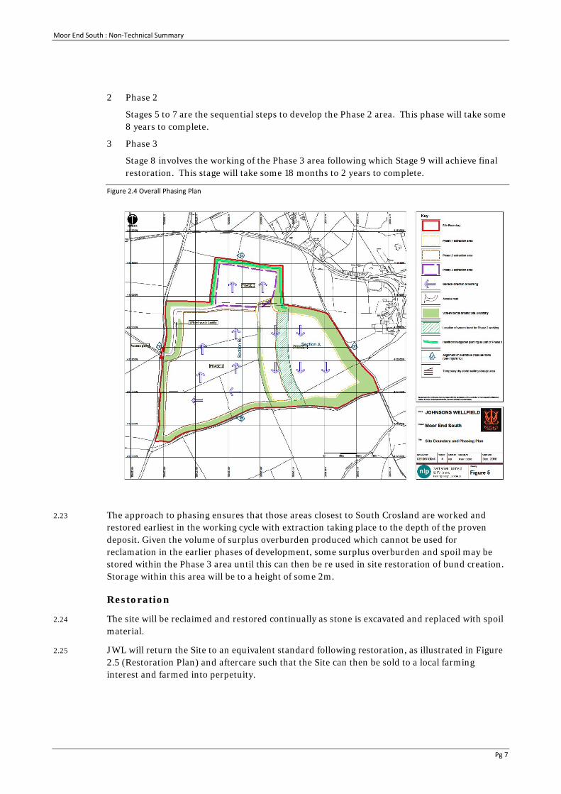
2 Phase 2
Stages 5 to 7 are the sequential steps to develop the Phase 2 area. This phase will take some 8 years to complete.
3 Phase 3
Stage 8 involves the working of the Phase 3 area following which Stage 9 will achieve final restoration. This stage will take some 18 months to 2 years to complete.
Figure 2.4 Overall Phasing Plan
2.23 The approach to phasing ensures that those areas closest to South Crosland are worked and restored earliest in the working cycle with extraction taking place to the depth of the proven deposit. Given the volume of surplus overburden produced which cannot be used for reclamation in the earlier phases of development, some surplus overburden and spoil may be stored within the Phase 3 area until this can then be re used in site restoration of bund creation. Storage within this area will be to a height of some 2m.
Restoration
2.24 The site will be reclaimed and restored continually as stone is excavated and replaced with spoil material.
2.25 JWL will return the Site to an equivalent standard following restoration, as illustrated in Figure 2.5 (Restoration Plan) and aftercare such that the Site can then be sold to a local farming interest and farmed into perpetuity.

Moor End South : Non-Technical Summary
Pg 8
Figure 2.5 Restoration Plan
Alternatives Considered
2.26 As part of the EIA, alternative sites and schemes have been considered. This has helped in identifying benefits and choices of site and the scheme, taking account of the environmental effects and is consistent with regulatory requirements.
2.27 JWL has undertaken a comprehensive site search over many years to identify options for the development of a new sandstone extraction site. That search has been limited by the available Rough Rock geology within the Kirklees area, the proximity of neighbouring land uses, accessibility and the willingness of the landowner to sell or lease the minerals deposit.
2.28 JWL has sought the identification of prospective sites as allocations or preferred areas within the Development Plan, and this process has assisted in the identification of suitable sites. Together with the consideration of potential environmental issues and the development process JWL has taken the decision not to progress a number of its target sites at the present time. The Company has however identified and acquired Moor End South, the only site available to it meeting its resource requirements.
Consultation and Design Evolution
2.29 A number of alternative design options have been considered and discounted on operational and environmental grounds
2.30 The Scheme has been developed iteratively, taking account of initial technical assessment and consultation feedback from both KC and interested parties including local residents.
2.31 An initial assessment of existing landscape character and visual amenity identified a number of viewpoints within the locality and in close proximity to the Site. These viewpoints were broadly

Moor End South : Non-Technical Summary
Pg 9
considered sensitive to the nature and scale of the working area and were previously evident in relation to the Airfield minerals extraction site to the north.
2.32 From an early stage of the design process, the following criteria were set out as being necessary components of the Scheme as follows:
1 Achieve a high proportion of screening of active minerals extraction working;
2 Avoid the storage of overburden in direct view or on the skyline;
3 Minimise the total area of disruption from agricultural use;
4 Provide productive grazing use on the screen bunds with the result that they will merge with rather than contrast to, the predominantly agricultural landscape setting;
5 Retain all soil resources through a comprehensive and detailed working scheme;
6 Consider dry stone wall resources and current field patterns as key landscape character features; and
7 The working scheme should provide an adequate supply of different stone resources.
Traffic and Transport
2.33 A detailed Transport Assessment has been undertaken which considers the impact of the scheme on transport and access.
Baseline
2.34 The baseline conditions for the study area surrounding the Scheme have been considered in relation to the following:
1 Local highway network;
2 Analysis of collision statistics;
3 Public Rights of Way including cycle and equestrian infrastructure; and
4 Public Transport infrastructure and service frequency.
2.35 A full review of the existing highway conditions is provided in ES Volume 1 Chapter E.
Assessment of potential significant effects
During Construction
2.36 No significant temporary or permanent effects of relevance to Transport were identified as a result of the site preparation works associated with the Scheme.
During Operation
2.37 During the course of the development, it is proposed that a maximum of 26 return HGV movements per day may be undertaken. The change in traffic profile on Arborary Lane/Nopper Road as a result of increases in HGV numbers associated with the Scheme has been assessed to have the potential to lead to a significant effect related to accidents and safety within the study area. The crossroad junction of Arborary Lane and Intake Lane was identified as being a receptor site of high sensitivity due to the high number of collisions at this location.

Moor End South : Non-Technical Summary
Pg 10
Cumulative Effects
2.38 The potential effect associated with the impact of increases in vehicle trip generations on other areas of assessment included within the EIA, namely air quality and noise, were also assessed to not result in any significant temporary or permanent detrimental effects.
Mitigation Measures
2.39 The following mitigation measures have been identified to be of relevance to the Scheme:
1 Review and implementation of signage and road markings at crossroad junction of Arborary Lane / Intake Lane;
2 Passing bays to be provided at intervals along Arborary Lane and Nopper Road.
2.40 Following the introduction of mitigation, the potential for significant effects resulting from changes in traffic composition as a result of the Scheme has been reassessed to have a minor adverse effect on accidents and is considered to not be significant.
Summary
2.41 It has been assessed that, following the introduction of mitigation measures, there will be no significant adverse effects resulting from either the construction or operation of the Scheme.
Landscape and Visual Impact
2.42 The Landscape and Visual Impact Assessment has been undertaken as part of the ES to evaluate the potential effects of the Scheme and has been carried out in adherence with industry guidelines and best practice.
2.43 A study area of approximately 4km from the Site was adopted. Twenty viewpoint locations were used to examine visual effects, the majority being from close and medium range distances, given potential views of the Site and the Scheme. The viewpoints and presentation methods were agreed with KC.
The Baseline Conditions
The Landscape Setting
2.44 The Site comprises agricultural pasture and is subdivided into eight fields by dry stone walls. The village of South Crosland is approximately 100m to the east of the Site boundary. There are several footpaths, bridleways and byways near the Site.
2.45 In the surrounding landscape, agriculture is the predominant land use and primarily consists of a small to medium-scale field pattern of regular grassland pastures. Areas of ancient and semi-natural woodland occur at Dean Clough (north-east) and Bank Wood (south). Smaller tracts of woodland can be found to the south-west of the Site at Edge Moor and along the eastern edge of Blackmoorfoot Reservoir. Larger settlement areas are generally beyond 1km.
Landscape Character
2.46 At a national level, the Site is located on the western periphery of the Yorkshire Southern Pennine Fringe National Character Area No.37. At a local level, the Kirklees District Landscape Character Assessment (2015) identifies the Site within the E1 Holmfirth-Meltham Landscape Character Area (LCA). Key characteristics include a distinctive pattern of dry stone walls and agricultural pasture fields.

Moor End South : Non-Technical Summary
Pg 11
Landscape Designations
2.47 The Site is not located within a national statutory designated area such as a National Park or an Area of Outstanding National Beauty (AONB). However, it is situated within an area of Green Belt (non-statutory) under the Kirklees Unitary Development Plan (1999). In addition, the Site and study area falls within the White Rose Forest.
2.48 South Crosland Conservation Area is c.100m east of the Site and the closest Scheduled Monument Crosland Lower Hall moated site (c.800m south-east to the site centre). The Peak District National Park is approximately 2.5km south-west from the Site.
Potential Effects
Sources of Impact
2.49 When considering landscape character, the main sources of impact will be a change from agricultural pasture fields and the removal of the dry stone walls. For visual effects, this includes visible extractive operations over a period of time and other site development operations to form the screen bunds and soil stripping. There will be changes to ground levels due to the screen bunds. The screen bunds will be grass seeded and once grassland has been established, they will be grazed by sheep which will complement the existing character.
Summary of Effects
2.50 The predicted landscape effects will be first and foremost at a local level and will bring about a large change to the E1 Holmfirth-Meltham LCA in terms of the Site (direct effects). Indirect effects will occur in terms of the character area within approximately 250m to 300m. However, at a further distance this will not be as profound in the context of the overall LCA.
2.51 Visual effects were examined for range of receptors (residents, footpath users, road users etc.). It was found that views of extractive operations were reduced due to the screen bunds. It was concluded that potential views of extractive operations will be limited overall and will not affect the overall quality of the scene given the location of the screen bunds. The screen bunds themselves will have less of a visual effect.
Mitigation Measures
2.52 The Site will be worked in a phased manner in a clockwise direction from the north-east, with progressive restoration taking place to ensure that agricultural pasture land is made available for farming use as soon as is practically possible. To reduce the potential effects of the extractive operations, screen bunds have been incorporated in the Scheme. Additional mitigation will be achieved by avoiding storage of overburden above ground unless otherwise specified in the phasing scheme.
Residual Effects
2.53 The Scheme involves the removal of an established pattern of dry stone walls and areas of agricultural pasture which are characteristics of the E1 Holmfirth-Meltham LCA. This represents the loss of an element of the landscape that contributes to the wider landscape character for a short period only. The presence of screen bunds (although visual) and the phased working minimises potential adverse effects and does not represent a permanent change to the landscape quality and distinctiveness. The Site will be restored to comparable ground levels as existing and facilitates the restoration of the landscape character and visual amenity, thereby ensuring that there will be no adverse residual effects post restoration.

Moor End South : Non-Technical Summary
Pg 12
Air Quality
2.54 An air quality assessment has been undertaken as part of the ES to assess potential air quality effects resulting from the Scheme. The assessment was undertaken in accordance with the Institute of Air Quality Management (IAQM) guidance documents, “Guidance on the Assessment of Dust from Demolition and Construction” and, “Guidance on the Assessment of Mineral Dust Impacts for Planning”.
During Construction
2.55 The scheme has the potential to impact on air quality during the site preparation (construction) phase as a result of dust emissions from the movement of soil and from the movement of construction vehicles onto the road network.
2.56 Traffic movements during the construction phase have the potential to increase vehicle exhaust emissions in the vicinity of Scheme, but these impacts have not been assessed in detail as the number of traffic movements is low and therefore they would not create any impacts.
2.57 The assessment of construction dust predicted there to be a ‘negligible’ to ‘low’ risk of dust effects before mitigation. Following the appropriate implementation of mitigation measures, impacts are predicted to be not significant.
During Operation
2.58 The operational phase has the potential to lead to dust emissions as a result of the extraction, handling and transport of sandstone mineral.
2.59 Traffic movements during the operation phase have the potential to increase vehicle exhaust emissions in the vicinity of Scheme, but these impacts have not been assessed in detail as the number of traffic movements is low and therefore they would not create any impacts.
2.60 The assessment of operational dust disamenity effects indicated that the Scheme is considered to have a ‘negligible’ effect on the surrounding area before mitigation. The designed in mitigation measures together with the operational measures are considered appropriate to reduce the impact further and therefore impacts are not significant.
2.61 The potential for human health impacts as a result of increased dust concentrations was considered and determined to be not significant as a result of the low background concentrations in the area and in design mitigation measures reducing emissions.
Residual Effects
2.62 Overall, assuming that the mitigation measures are appropriately incorporated and maintained, the Scheme is not considered to be significant with regards to potential air quality impacts.
Noise and Vibration
2.63 The assessment of the potential noise and vibration effects of the Scheme has considered initial Site works, extraction activities and reinstatement works and has focussed on the nearest residential receptors around the Site. Relevant standards and guidance have been referenced in adopting the method of assessment. The approach to and scope of the assessment has been agreed in consultation with Kirklees Council. The potential for vibration effects to occur at off-site receptor has been considered, however as blasting will not occur on the Site and there are no other activities proposed that are likely to cause off-site vibration, it has been scoped out of this assessment and is not addressed further. The method of noise assessment comprised:

Moor End South : Non-Technical Summary
Pg 13
1. Measurement of existing baseline (including background) noise levels;
2. Derivation of noise limits and evaluation criteria from measured background noise levels;
3. Prediction of noise levels during each of the three stages of the project, and specifically for each of the nine phases of extraction activities;
4. Evaluation of the predicted noise levels against the derived criteria to determine their level of significance;
5. Incorporation of measures into the Scheme design to mitigate noise impacts.
2.64 Initial Site works will include the stripping of soils and overburden and the creation of screening mounds around the site in advance of any mineral extraction work commencing. It is recognised that the benefit of noise reduction provided by these mounds will not be realised until their construction is complete, therefore noise levels during these enabling activities are expected to be higher than during subsequent extraction operations. The initial Site works phase has therefore been assessed separately from the three phases of extraction operations. The extraction phases of the Scheme have been considered individually and in combination (where any activities on different phases occur simultaneously).
2.65 Cumulative noise levels have been assessed taking account of simultaneous activities on six other developments whose activities will for at least some of the time be simultaneous with the Scheme including : Thewlis Lane; Airfield; Waterholes; Moorfield; Crosland Hill; and Wellfield developments.
2.66 A baseline noise survey has been carried out at each of the five locations agreed with the Council:
1. Noise sensitive Receptors (NSR)1, Intake Lane at Moor End Farm;
2. NSR2, Crosland South, Junction of Magdin Lane and Midway;
3. NSR3, Crosland Spring Road;
4. NSR4, Reservoir Side Road at SE corner of Blackmoorfoot Reservoir; and
5. NSR5, Junction of Reservoir Side Road and Black Lane, Blackmoorfoot.
2.67 The existing noise environment is characterised at most of the above receptors by infrequent road traffic on local roads, by the sound of vegetation in the breeze and by birdsong. At NSR4, the local noise environment is dominated by regular traffic on the B6108. The measured background noise levels have been used to derive proposed noise limits for the extraction activities. Fixed noise limits during initial Site works and reinstatement that are higher than for extraction activities have been established by referencing the relevant Standard.
2.68 Detailed information on the design and phasing of workings and on the inventory of plant that will be utilised in all phases of the project have been provided by Johnsons Wellfield Ltd. Noise levels for all phases of the Scheme have been predicted in accordance with the relevant Standard by taking the source noise level for each plant item and subtracting a number of attenuation factors (distance, atmospheric absorption, ground type and screening mounding effects). Cumulative noise levels have been predicted at each of the noise sensitive receptors, taking account of the activities on the other six minerals extractive projects.
2.69 Measures to mitigate noise effects have been committed to by Johnsons Wellfield Ltd to manage and reduce noise levels. These include:

Moor End South : Non-Technical Summary
Pg 14
1. Proper use of plant with respect to minimising noise emissions and regular maintenance. All vehicles and mechanical plant used for the purpose of the works will be fitted with effective exhaust silencers and will be maintained in good efficient working order;
2. Selection of inherently quiet plant where appropriate. All plant will be fitted with properly lined and sealed acoustic covers which will be kept closed whenever the machines are in use and will be fitted with mufflers or silencers of the type recommended by the manufacturers;
3. Machines in intermittent use will be shut down when not working, or will be throttled down to idle; and
4. Broadband ‘white noise’ alarms will be fitted to the mobile plant to reduce the likelihood of annoyance arising during reversing, in place of ‘beeper’ alarms.
2.70 Predicted noise levels at each NSR during initial Site works are below the adopted fixed noise limit. The significance of the noise impact at these receptors during initial Site works is expected to be negligible. The noise impacts, including cumulative noise impacts, at the closest NSRs during the extraction phases are predicted to be within the adopted limits at all NSRs for all phases of the Scheme. The impacts have been evaluated as being within the range of moderate to negligible. Noise impacts from the Scheme at all receptors are not anticipated to be significant in terms of the EIA regulations.
2.71 The likely significant noise and vibration effects of the development have been assessed in accordance with published guidelines. The assessment included the monitoring of existing noise levels informed by a site survey and the identification of local receptors which would be most sensitive to noise and vibration.
Hydrogeology and Ground Conditions
2.72 The ES Chapter on ground and hydrogeology has assessed the potential effects of the scheme on ground conditions, ground gas, and soil/groundwater contamination.
2.73 The Site is in agricultural use and has remained undeveloped throughout its identifiable history. It comprises agricultural land divided by a series of dry stone walls.
2.74 The geology underlying the site comprises Rough Rock Sandstone and Rough Rock Flags which form part of the Millstone Grit Series. Drift deposits are recorded to be absent; however, a layer of topsoil and subsoil is present at the surface resulting from its agricultural use.
2.75 The Scheme involves the extraction of a high quality ashlar sandstone from several horizons within the Rough Rock Sandstone and the extraction of sandstone block, flagstone, walling stone and aggregate, from excavations up to a depth of approximately 25m below existing ground level.
During Construction and Operation
2.76 Experience gained through the operation of Thewlis Lane and other nearby stone quarries confirms that seepages of perched groundwater occur at relatively shallow depths within the excavation. Where this occurs, groundwater drains intermittently into the site and drains freely through the base of the excavation maintaining dry working conditions.
2.77 A potential impact of the scheme is that higher volumes of groundwater may be generated due to rain falling into open excavation or stripped areas. In this eventuality, water would be diverted to soakaway through the quarry floor and no discharge off-site will take place.

Moor End South : Non-Technical Summary
Pg 15
Mitigation Measures
2.78 A site management plan will be prepared to include a watching brief to monitor the presence of ground contamination and a contingency plan to deal with it.
2.79 The removal of bed rock and re-instatement of the Site with natural site won materials will increase the permeability of the ground, having the effect of introducing enhanced pathways and increasing the ground gas / groundwater storage capacity of the reinstated Site.
2.80 Monitoring should be carried out during the restoration of the site to confirm the significance (if any) of this potential effect. Gas venting or drainage arrangements should be installed prior to completion if necessary.
After Completion
2.81 Following extraction, the site will be restored with natural materials to an approved landscaping strategy.
Hydrology and Flood Risk
2.82 The ES chapter on water and drainage provides an assessment of the potential impact of the Scheme on flood risk and surface water in the study area.
2.83 The assessment has been undertaken in accordance with policies on flood risk and drainage set out in the National Planning Policy Framework and associated Technical Guidance, and these have been considered in the Flood Risk Assessment (“FRA”) undertaken for the Scheme. The principle aims are to ensure that flood risk is taken into account at all stages, and to avoid inappropriate development in areas at risk of flooding, and to direct development away from areas of highest risk.
2.84 Consultation has been undertaken with the Environment Agency and Kirklees Council as Lead Local Flood Authority (“LLFA”). The EA confirmed that the site lies within flood risk Zone 1, considered as low risk of flooding. The LLFA stated that any flows emanating from the Site should be maintained so as to preserve flows to downstream watercourses.
Existing Drainage
2.85 A land drainage system emerges from the site in the east and discharges via a carrier drain that follows the valley heading east towards the junction of School Hill, Midway and Sandy Lane. The carrier drain feeds the water troughs at the School Hill, Sandy Lane junction.
2.86 An unnamed watercourse runs from the ground on the southern side of School Hill at the junction with Turbid Lane. The watercourse flows via a ditch alongside School Hill for approximately 50m before becoming culverted beneath the highway and feeding Dean Clough to the east.
2.87 At the southeast corner of the Site, to the south of Whitehead Road, a ditch flows south alongside the track heading away from the Site. The ditch receives a piped outfall from highway drainage within Whitehead Road.
Flood Risk and Surface Water Assessment
2.88 The Site generally lies at higher ground level than the surrounding area to the east and south. Off-site areas to the north and west are marginally higher than the Site, but any overland flow, however unlikely, from these directions would be intercepted by the highways and channelled away from the Site.
Moor End South : Non-Technical Summary
Pg 16
2.89 Surface water flow pathways are shown in the northeast and southeast corner of the site, however any above ground flows would follow the local topography towards the valleys to the north and south of South Crosland and would not pose a flood risk to South Crosland village.
2.90 The Blackmoorfoot Reservoir is situated approximately 0.5km to the west of the Site. Any flooding associated with breach or failure of the reservoir is predicted to occur to the north and south of the reservoir, flowing away from the Site.
Potential effects
2.91 The Site currently drains via infiltration and land drainage. It is proposed to maintain the existing drainage regime during the Scheme and for the restored Site by using the existing land drainage outfall in the east, and connecting the land drainage installed during construction to the existing outfall. The existing land drainage outfall discharges to the water troughs further to the east and flows will be maintained thereby continuing to provide a water supply to the troughs.
2.92 The proposed perimeter land drainage system will comprise a filter drain in a shallow trench filled with stone. The filter drain will allow infiltration to the surrounding ground and provide storage and treatment of surface water runoff from the perimeter of the site and areas yet to be worked.
2.93 The South Crosland residential area is located at a higher level than the eastern boundary of the site. Therefore, any surcharging of the perimeter land drainage system or overland flow along the eastern boundary, however unlikely, would follow the local topography and the valley that heads north east, past the junction of School Hill, Midway and Sandy Lane, towards Dean Clough, and not towards the residential area of South Crosland.
2.94 Any rainfall falling on the extraction void would percolate into the bedrock, the base of which will be at a significantly lower level than the site perimeter. Therefore, runoff in the extraction void will be unable to discharge above ground to off-site areas, and would not be able to drain towards the residential area of South Crosland.
2.95 The proposed drainage system will aim to replicate the existing system by maintaining existing land drainage outfalls, therefore the effects of climate change are not predicted to increase runoff over and above the existing site conditions.
2.96 The provision of the land drainage system will provide filtration of runoff, thereby maintaining the existing treatment mechanism of runoff provided by the existing land drainage system.
2.97 The Site will be restored to agricultural land as per the current greenfield conditions. Land drainage systems will be installed as per the existing site and existing drainage outfalls will be utilised. In the low lying area in the south east of the Site, a slight depression will be created that will receive land drainage flows from southern areas of the Site. It is anticipated that the depression will be seasonally inundated and will provide ecological enhancement and benefit. The proposed water body lies within the area shown on EA mapping to be at risk of surface water flooding so is considered appropriate in this location. The proposed depression will provide additional attenuation volume for site runoff in the low lying south east corner of the site, however in the unlikely event of any surcharging of the water body during an extreme rainfall event, overland flows would follow the recognised flow paths on the EA mapping, heading south, and would match the current situation.
2.98 In summary there will be no adverse impact on flood risk and water quality in the surrounding area.

Moor End South : Non-Technical Summary
Pg 17
Ecology and Nature Conservation
2.99 The ecology assessment has considered the potential effects of the Scheme on designated sites, habitats and protected and notable species within and adjacent to the Site.
2.100 The assessment methodology followed the broad approach to ecological impact assessment in the CIEEM Guidelines for Ecological Impact Assessment in the UK and Ireland Second Edition (CIEEM 2016).
2.101 The assessment was informed by a desk study, field survey and consultation with WYES in its capacity as ecological advisor to KMC, and the Kirklees Council Ecologist.
2.102 There are no Statutory or non-Statutory sites in the immediate vicinity of the Site. The South Pennine Moors Special Protection Area (SPA) which is designated for its internationally important breeding assemblage of merlin (Falco columbarius), golden plover (Pluvialis apricaria) and twite (Carduelis flavirostris). Golden plover are known to feed on suitable habitats outside the SPA during the breeding season. A project level Habitat Regulations Assessment (HRA) was therefore undertaken to assess any likely significant effect of the Scheme on golden plover associated with the SPA.
2.103 The Site comprises intensively managed grassland which is cut for silage with only limited potential to support protected or notable species, namely badger, brown hare and breeding and wintering birds, the site is not considered suitable to support feeding golden plover which have a preference for very short sward heights (<10cm).
During Construction
2.104 Without mitigation, the potential effects of the Scheme during the construction phase comprise loss of improved grassland and arable land and loss of or disturbance to habitat for badger, brown hare, breeding birds and wintering birds.
2.105 These effects would be temporary since the Site would be restored to its current agricultural use on cessation of operations.
After Completion
2.106 After completion, the potential effects of the Scheme with restoration in place would be the restoration of improved grassland/arable land, the creation of a soakaway and the restoration of suitable habitat for badger, brown hare and breeding/wintering birds. Restoration would necessitate the removal of the hedgerow to be created on the northern boundary. However, this would be balanced with the creation of the soakaway feature and re-instatement of agricultural grassland for use by badger, brown hare and breeding and wintering birds which would be beneficial.
2.107 The soakaway is also expected to be of value for snipe which favour damp grassland habitat.
2.108 The project level HRA concludes that the Site is unlikely to be used by golden plover associated with the SPA due to distance from the SPA, desk study data which shows now records of golden plover from the Site or surrounding fields and the management of the fields for silage which means that the grass sward height would rapidly become too tall for golden plover feeding (i.e. greater than 10cm in height). The HRA therefore concludes that there would be no likely significant effect on the South Pennine Moors SPA, and that no appropriate assessment would be required.

Moor End South : Non-Technical Summary
Pg 18
Mitigation Measures
2.109 Mitigation for ecological effects during the construction phase would comprise phasing of working to allow time for ecological receptors to adjust to disturbance and displacement effects, use of screening bunds to reduce noise and visual disturbance, dust and noise minimisation measures, temporary habitat creation of a hedgerow along the northern Site boundary and sensitive timing and methods of working prior to and during soil stripping to avoid accidental injury/killing of individual brown hare and nesting birds.
2.110 With the above mitigation in place, it is assessed that there would be no residual effects on ecology during the construction phase.
Archaeology and Heritage
2.111 The archaeology and heritage assessment has considered the potential effects of the scheme on archaeology and heritage considerations within and in the vicinity of the site. The assessment has comprised a desk based assessment and a geophysical survey.
2.112 The study has revealed that there are no designated sites (e.g. scheduled monuments, listed buildings) within the site. There are no World Heritage Sites, registered battlefields, or registered parks and gardens located within 1km of the Site.
2.113 There is one scheduled monument located within 1km of the proposal site. This is Crosland Lower Hall moated site (list entry number 1013896), located some 750m southeast of the proposal site at Lower Hall.
2.114 There are 32 listed buildings located within 1km of the proposal site. Each of these buildings is listed at Grade II. Sixteen of these listed buildings are located within the South Crosland conservation area.
2.115 There is one conservation area located within 1km of the Site. This is the South Crosland conservation area.
2.116 There is evidence for prehistoric activity in the wider area. A geophysical Survey carried out in connection with the proposed development has indicated that there are no similar remains within the proposal site. The evidence indicates that proposal site itself has been agricultural land from antiquity onwards. There is no recorded evidence for activity, other than use as agricultural land over the proposal site. There is no evidence for the proposal site to contain below ground remains of the highest significance, or of sufficient significance to warrant preservation in situ.
During Construction and Operation
2.117 Views towards the Site from the conservation area are generally likely to screened by development and difficult to obtain. From the areas of the conservation area where the Site is currently visible, landscape bunding would reduce both the visibility and sense of the proposed development. From outside the conservation area looking in, combination views of the conservation area and the Scheme would be difficult to obtain.
2.118 The Scheme will result in a number of changes to landscape elements to the west of the conservation area, some of which lie within the setting of the conservation area. With the proposed landscape bunding, the impact of the proposed development on the setting of the conservation area is assessed as being low. The effect of the Scheme on the conservation area is assessed as moderate.

Moor End South : Non-Technical Summary
Pg 19
2.119 There is evidence for prehistoric activity in the wider area. It is possible that there are similar remains within or adjacent to the Site. There is however, no evidence for remains of sufficient interest to require preservation in situ. The effect of the Scheme on known archaeology within the Site is assessed as being at most minor.
Mitigation Measures
2.120 The phasing of the works allows a relatively small area to be excavated at any one time, thus minimising any impacts on the settings of heritage assets.
2.121 A programme of fieldwork, recording and reporting is proposed to be undertaken during construction (soil and overburden stripping). This may include archaeological monitoring/ control of soil stripping, with an appropriate level of excavation and recording of archaeological features.
2.122 The programme outlined above will be based on the results of the geophysical survey to ensure that any areas of archaeological interest are anticipated and fully resourced. Mitigation would be complete following the construction phase and no future monitoring would be required.
2.123 The remaining boundary alignments both within and around the Site would be either preserved in situ, or reinstated and the landscape pattern would remain unchanged.
After Completion
2.124 Following completion and restoration, effects on buried archaeological remains would be identical to those at the end of the construction process. Effects on the settings of designated assets broadly would return to their pre-construction state.
Socio Economic Effects
2.125 A wide range of potential socio-economic effects associated with the construction and operation of the Scheme were assessed in the Socio-Economics assessment. This focused on effects arising within Kirklees, though some effects such as supply chain expenditure are expected to extend beyond this area. The assessment outlined the potential beneficial impacts that are likely to arise from the Scheme, such as new and safeguarded employment in a productive industry, as well as highlighting the adverse impact to the economy if the Scheme were not to go ahead.
2.126 Kirklees’ economy has strengths in its manufacturing industry, has high levels of apprenticeships and competitive wages for businesses. However it also has some weaknesses compared to the rest of Yorkshire and the Humber and the UK. Kirklees has a productivity gap, which means that each worker typically produces less output per hour worked. This needs to be addressed in order to increase prosperity and wages for local residents. The qualifications held by the local workforce could also be improved when compared to the region and the UK, for example with greater numbers of graduates with degrees.
2.127 JWL is an important business for the local economy. It is within one of the more productive industries nationally, and in comparison to the local economy has higher levels of productivity. In recent years JWL has made considerable investments in capital equipment and its workforce’s skills and training. It plays an important role in the supply chain across Kirklees and Yorkshire. JWL plans to grow its revenue base to £10 million by 2024, and the Scheme is a key component of this growth strategy. Ensuring it has an extractable supply of hard Yorkstone is fundamental to JWL’s ability to provide a range of high quality products which are in demand across the UK. Retaining and supporting the future growth of JWL also aligns with local economic policy.
Moor End South : Non-Technical Summary
Pg 20
2.128 The Scheme is considered to be integral to the future retention and growth of JWL in Kirklees. The Scheme has a maximum lifetime of 20 years, and its development will help JWL to achieve its target to grow revenue to £10 million by 2024. This in turn will help JWL to continue to invest in the local economy and workforce.
2.129 The assessment concluded that no mitigation measures were required for socio-economic effects. This is because JWL already has a clear commitment to the local economy and to supporting Kirklees’ economic objectives.
2.130 The assessment considered that the Scheme will have a minor beneficial impact from the 22 direct and ‘spin-off’ temporary construction jobs created during the site preparation phase.
2.131 Operation of the Scheme would have a number of socio-economic effects, all of which are considered to be beneficial. There would be a moderate beneficial impact from the 11 direct and ‘spin-off’ jobs created by the Scheme, and the 187 existing direct and ‘spin-off’ jobs that would be safeguarded. This reflects the importance of the Scheme to JWL’s future growth, and the importance of retaining productive and high quality jobs in Kirklees.
2.132 The Scheme will also allow JWL to continue supporting the training and skills development of its workforce, the majority of which are residents living in Kirklees. This would have a minor beneficial impact on training and skills development. This is based on JWL’s history of developing its workforce and the range of training courses and qualifications achieved by its staff. JWL is committed to ensuring this continues.
2.133 The Scheme would have a minor beneficial impact from supply chain expenditure. The benefits from the upfront expenditure on new extraction plant is most likely to be captured across the UK, depending on the choice of contractor it may have more local benefits. It will nether-the-less have a small but beneficial impact. Additionally, JWL will continue to support the local supply chain over the operational lifetime of the Scheme.
2.134 JWL’s Scheme will also help contribute towards local and national economic objectives, such as ensuring productive businesses can continue to grow and developing workforce skills.
2.135 The assessment highlighted that if the Scheme did not go ahead it would have a moderate adverse impact. The Scheme is vital to the future growth of JWL, which is an important business for Kirklees. Without the Scheme, the new and existing jobs would be at risk. This also means that JWL’s workforce skills development would reduce or stop, and its spending in the local supply chain would decrease or be lost. As an innovative business that has aspirations to grow and keep investing in Kirklees, JWL needs the Scheme for its future success.
2.136 The assessment reported that there are proposals for additional housing, a primary school and employment space in the local area near to the Site. These have the potential to come forwards over the same time period as the Scheme. This means there is likely to be some additional local demand for JWL’s products, as well as increased employment opportunities during construction and operation. This is expected to have a minor beneficial impact.

Moor End South : Non-Technical Summary
Pg 21
3.0 Cumulative Effects and Summary of Key Findings
3.1 Table 3.1 reviews whether the inter-relationship between effects arising from the development, and other developments in the local area, may give rise to additional impacts which had not been previously identified.
Table 3.1 Residual Effects
Environmental Topic Effects During Construction
Effects During Operation Effects After Restoration
Traffic and Transport Neutral Minor Adverse Neutral Landscape and Visual Impacts (Extraction)
Adverse Adverse Neutral
Landscape and Visual Impacts (Screen Bunds)
Minor Adverse Minor Adverse Neutral
Air Quality Minor Adverse Minor Adverse Neutral Noise and Vibration Negligible Moderate to Negligible Neutral Hydrogeology and Ground Conditions
Minor Adverse Minor Adverse Negligible
Hydrology and Flood Risk Neutral Neutral Neutral Ecology and Nature Conservation
Neutral Neutral Neutral to Minor Beneficial
Below Ground Archaeology within the Site
Minor Adverse Minor Adverse Neutral
Historic Landscape Minor Adverse Minor Adverse Minor Adverse Designated Heritage Assets Moderate Adverse Moderate Adverse Minor Adverse Socio Economic Effects Minor Beneficial Minor to Moderate
Beneficial Neutral
3.2 A range of mitigation measures have been identified throughout the ES which are capable of being enforced through planning condition and/or legal agreement in relation to the scheme.
3.3 The relationships between the effects identified on site do not give rise to a need for additional mitigation measures in relation to the development, and cumulative effects arising from the development when considered with other developments in the surrounding area do not give rise to a need for additional mitigation measure that have not been previously identified in this ES.

Moor End South : Non-Technical Summary
Pg 22
4.0 Availability of Environment Statement 4.1 A paper or electronic copy of the ES can be obtained from:
• Lichfields, Third Floor, 15 St Paul’s Street, Leeds, LS1 2JG
• Tel: +44(0)113 3971397
• The cost for the paper copy is £150 plus VAT. CD copies are available at £5 plus VAT and postage.
4.2 Information on the planning application and the ES can also be viewed at the offices of Johnsons Wellfield Limited:
• Thewlis Lane, Crosland Hill, Huddersfield, HD4 7AB
4.3 or during the opening hours of KMC at the following address:
• Civic Centre 3, Market Street, Huddersfield, HD1 2YZ


Environmental Statement
Crosland Moor
Johnsons Wellfield LimitedMARCH 2017