ROM SAF CDOP-2 Product Output Format 1.4 02/09/08 MBS Updated to include ORR-A decisions ... ROM SAF...
29
Ref: SAF/ROM/DMI/FMT/POF/001 ROM SAF CDOP-2 Product Output Format Version 2.2 9 July 2014 Danish Meteorological Institute (DMI) European Centre for Medium-Range Weather Forecasts (ECMWF) Institut d’Estudis Espacials de Catalunya (IEEC) Met Office (MetO)
Transcript of ROM SAF CDOP-2 Product Output Format 1.4 02/09/08 MBS Updated to include ORR-A decisions ... ROM SAF...
Ref: SAF/ROM/DMI/FMT/POF/001
ROM SAF CDOP-2
Product Output Format
Version 2.2
9 July 2014
Danish Meteorological Institute (DMI) European Centre for Medium-Range Weather Forecasts (ECMWF)
Institut d’Estudis Espacials de Catalunya (IEEC) Met Office (MetO)
Ref: SAF/ROM/DMI/FMT/POF/001 Issue: 2.2 Date: 9 July 2014
ROM SAF CDOP-2 Product Output Format
2 of 29
DOCUMENT AUTHOR TABLE
Author(s) Function Date Comments Prepared by: Hallgeir Wilhelmsen ROM SAF Project Team 05/05/14
Reviewed by (internal):
Approved by: Kent Bækgaard Lauritsen
ROM SAF Project Manager 05/05/14
DOCUMENT CHANGE RECORD
Issue / Revision Date By Description Version 0.1 17/11/04 MBS 1st draft (for I-RR) Version 0.2 23/02/05 MBS 2st draft including UMARF – SAF attribute
table Version 1.0 08/06/05 MBS HDF5 replaced with NetCDF
Added description of the format of the NetCDF files (ROPP format)
Version 1.1 24/11/05 MBS Updated according to UMARF TEN 030 issue 1 revision 5
Version 1.2 23/11/06 MBS Further specification on the product types Version 1.3 15/05/08 MBS Name convention and ROPP file
description updated Version 1.4 02/09/08 MBS Updated to include ORR-A decisions
The RID numbers which this update relates to are 17, 18, and 58.
Version 1.5 30/03/09 MBS Update related to declaring the NRT Refractivity Product pre-operational
Version 1.5.1 31/03/09 MBS Minor corrections to version 1.5 Version 1.6 11/05/09 MBS Minor corrections to version 1.5.1 Version 1.7 08/02/11 SSY ORR-B1 RIDs 30 → 36, 55, 78 → 80,
117, and 118 implemented for Close-Out Version 1.8 09/06/11 FRR Updates according to Action 2 from ORR-
B1 Close-Out Version 1.9 16/01/12 HW Release for ORR2. GPAC processing file
names section updated. Level 3 products added.
Ref: SAF/ROM/DMI/FMT/POF/001 Issue: 2.2 Date: 9 July 2014
ROM SAF CDOP-2 Product Output Format
3 of 29
2.0 04/04/13 HW Updated version for ORR2 closeout. All ORR2 RIDs implemented (nos. 41, .., 53).
2.1 17/5/13 KBL Version closing Action 1, points 4), ..., 11) [by A.K.S] and point 13) [by P.P.] in Annex 2 of the Minutes from the ORR2 Closeout; In table 5-3 ‘Prid’ changed to ‘Prdid’; Approved as SG12-Dec-11
2.2 9/7 2014 HW Version for ORR4 and ORR-B-backlog review. Some editorial changes made. Approved as SG15-Dec-06 (wp July 2014)
ROM SAF
The Radio Occultation Meteorology Satellite Application Facility (ROM SAF) is a decentralised processing center under EUMETSAT which is responsible for operational processing of GRAS radio occultation data from the Metop satellites and radio occultation (RO) data from other missions. The ROM SAF delivers bending angle, refractivity, temperature, pressure, and humidity profiles in near-real time and offline for NWP and climate users. The offline profiles are further processed into climate products consisting of gridded monthly zonal means of bending angle, refractivity, temperature, humidity, and geopotential heights together with error descriptions. The ROM SAF also maintains the Radio Occultation Processing Package (ROPP) which contains software modules that will aid users wishing to process, quality-control and assimilate radio occultation data from any radio occultation mission into NWP and other models. The ROM SAF Leading Entity is the Danish Meteorological Institute (DMI), with Cooperating Entities: i) European Centre for Medium-Range Weather Forecasts (ECMWF) in Reading, United Kingdom, ii) Institut D'Estudis Espacials de Catalunya (IEEC) in Barcelona, Spain, and iii) Met Office in Exeter, United Kingdom. To get access to our products or to read more about the ROM SAF please go to: http://www.romsaf.org Intellectual Property Rights
All intellectual property rights of the ROM SAF products belong to EUMETSAT. The use of these products is granted to every interested user, free of charge. If you wish to use these products, EUMETSAT's copyright credit must be shown by displaying the words “copyright (year) EUMETSAT” on each of the products used.
Ref: SAF/ROM/DMI/FMT/POF/001 Issue: 2.2 Date: 9 July 2014
ROM SAF CDOP-2 Product Output Format
4 of 29
List of Contents
List of Contents .......................................................................................................................... 4
1. Introduction ......................................................................................................................... 5 1.1 Purpose of document .......................................................................................................... 5 1.2 Applicable and reference documents ........................................................................... 5
1.2.1 Applicable documents ...................................................................................................................5 1.2.2 Reference documents ...................................................................................................................6
1.3 Acronyms and Abbreviations .......................................................................................... 6 1.4 Definitions ................................................................................................................................ 7
2. General Description ......................................................................................................... 8
3. Product Format Drivers .................................................................................................. 9
4. Input Data Formats......................................................................................................... 10
5. ROM SAF Format Definition ....................................................................................... 11 5.1 Structure ................................................................................................................................. 11
5.1.1 NetCDF compatibility .................................................................................................................. 12 5.2 File names ............................................................................................................................. 12
5.2.1 NRT version ..................................................................................................................................... 12 5.2.1.1 Explanation ............................................................................................................................................. 12 5.2.1.2 Example .................................................................................................................................................... 13
5.2.2 OFFLINE level 1 and level 2 ................................................................................................... 13 5.2.2.1 Explanation ............................................................................................................................................. 13 5.2.2.2 Example .................................................................................................................................................... 13
5.2.3 Offline level 3 version (climate data) ................................................................................... 13 5.2.3.1 Explanation ............................................................................................................................................. 13 5.2.3.2 Example .................................................................................................................................................... 13
5.3 File structure ........................................................................................................................ 15 5.3.1 Description of the ROM SAF product levels.................................................................... 15
5.4 Dissemination Media ......................................................................................................... 17 5.4.1 Disseminated Products Format ............................................................................................. 17 5.4.2 RMDCN Network .......................................................................................................................... 17 5.4.3 EUMETCast ..................................................................................................................................... 17 5.4.4 Offline Distribution ........................................................................................................................ 18
Ref: SAF/ROM/DMI/FMT/POF/001 Issue: 2.2 Date: 9 July 2014
ROM SAF CDOP-2 Product Output Format
5 of 29
1. Introduction 1.1 Purpose of document This document describes the product output format definitions used in the ROM SAF. It is addressed to end users of the ROM SAF data products. The ROM SAF NRT operational system produces refractivity, temperature and humidity profiles from observations made by the GPS receiver onboard the Metop satellites. Data is received from EPS CGS, and processed to level 2 products. These products are described in the Product Requirements Document [AD.5]. Metop input data is level 1b data received from EPS CGS through the EUMETCast terminal placed at the host institute. Auxiliary data sources are the forecasts and analyses received from ECMWF. Product information is reported to UMARF in the form of metadata. This is done via the UMARF Client, physically situated at the host institute. Users may request off-line products via the EUMETSAT Date Centre (UMARF). The NRT product generation and delivery will be completed within 3 hours from the actual observation time. Off-line products from Metop and other RO missions will be available to the users within 30 days after the measurement (the timeliness for some offline level 3 products may be up to 6 months). The requirements on the ROM SAF system in terms of product contents, product formats and distribution are expressed in the Software Requirements Document (SRD) [RD.2]. These are the bases for establishing the data format applicable to the system. In terms of data involved in the ROM SAF products generation and distribution, the following rationale applies:
• Level 1b data is ingested in the system, processed by dedicated components and archived. The generated products are listed in Appendix B.
• NRT products are distributed to the user community through GTS/RMDCN and EUMETCast. The off-line products are made available at the ROM SAF website and for request through UMARF.
1.2 Applicable and reference documents
1.2.1 Applicable documents The following list contains documents with a direct bearing on the contents of this document: [AD.1] ROM SAF Design Document (part 1, system),
Ref: SAF/GRAS/IEEC/DPR/ADD/001 [AD.2] ROM SAF ROPP (Radio Occultation Processing Package) File Format,
Ref: SAF/GRAS/METO/FMT/ROPP/001 [AD.3] ROM SAF WMO FM94 (BUFR) Specification for GRAS SAF Processed Radio
Occultation Data, Ref: SAF/GRAS/UKMO/FMT/BUFR/01 [AD.4] GRAS Level 1 Product Format Specification. Ref: EPS/MIS/SPE/97234 [AD.5] ROM SAF Product Requirements Document,
Ref: SAF/ROM/DMI/MGT/PRD/001 [AD.6] UMARF to SAFs Interface Control Document. Ref: EUM/UMA/ICD/004 [AD.7] UMARF – SAF Metadata Definiton Ref: EUM/OPS/TEN/07/1052 [AD.8] CDOP-2 Proposal: Proposal for the Second Continuous Development and Operations
Ref: SAF/ROM/DMI/FMT/POF/001 Issue: 2.2 Date: 9 July 2014
ROM SAF CDOP-2 Product Output Format
6 of 29
Phase (CDOP-2); Ref: SAF/GRAS/DMI/MGT/CDOP2/001 Version 1.1 of 21 March 2011, approved by the EUMETSAT Council in Ref. EUM/C/72/11/DOC/10 at its 72nd meeting on 28-29 June 2011;
[AD.9] CDOP-2 Cooperation Agreement: Agreement between EUMETSAT and DMI on the Second Continuous Development and Operations Phase (CDOP-2) of the Radio Occultation Meteorology Satellite Applications Facility (ROM SAF), approved by the EUMETSAT Council; Ref: EUM/C/72/11/DOC/15 at its 72nd meeting on 28-29 June 2011 and signed on 29 June 2011 in Copenhagen;
1.2.2 Reference documents The following documents provide supplementary or background information, and could be helpful in conjunction with this document: [RD.1] ROM SAF Science Plan,
Ref: SAF/GRAS/DMI/ALG/SP/001 [RD.2] ROM SAF System Requirement Document,
Ref: SAF/GRAS/DMI/RQ/SRD/001 [RD.3] The Radio Occultation Processing Package (ROPP) User Guide, Part I.
Ref: SAF/ROM/METO/UG/ROPP/002 [RD.4] UMARF UMRS, Ref: EUM/UMA/SPE/001 [RD.5] ROM SAF Product User Manual,
Ref: SAF/ROM/DMI/UG/PUM/001
1.3 Acronyms and Abbreviations
ADD Architectural Design Document (ROM SAF) BUFR Binary Universal Form of Representation CDA Command and Data Acquisition station (EUMETSAT/NOAA) CGS Core Ground Segment (EPS) CORBA Common Object Request Broker Architecture DMI Danish Meteorological Institute ECMWF European Center for Medium-range Weather Forecast EPS EUMETSAT Polar satellite System EPS CAL/VAL EPS Calibration and Validation facility EUMETCast EUMETSAT’s Broadcast System for Environmental Data EUMETSAT EUropean organisation for the exploitation of METeorological SATellites FTP File Transfer Protocol GARF GRAS SAF Archival and Retrieval Facility GNSS Global Navigation Satellite System GPS Global Positioning System (US) GRAS GNSS Receiver for Atmospheric Sounding (METOP instrument) GRAS GSN GRAS Ground Support Network GTS Global Telecommunication System IEEC Institut d’Estudis Espacials de Catalunya (Spain) IGS International Geodynamics Service METOP METeorological Operational Polar satellite (EPS/EUMETSAT) N/A Not Available/Applicable NRT Near-Real Time

Ref: SAF/ROM/DMI/FMT/POF/001 Issue: 2.2 Date: 9 July 2014
ROM SAF CDOP-2 Product Output Format
7 of 29
NWP Numerical Weather Prediction PDU Product Dissemination Unit: reflects the granularity to which a product is sent to
the EUMETCast terminals of the CGS NRT Users POD Precise Orbit Determination RMDCN Regional Meteorological Data Communication Network (GTS) TBC To Be Considered TBD To Be Determined/Decided/Discussed UKMO The UK Meteorological Office (aka: Met Office) UMARF Unified Meteorological Archive and Retrieval Facility (EUMETSAT) WMO World Meteorological Organisation WWW World Wide Web, component of the Internet data access system XML Extensible Mark-up Language
1.4 Definitions
RO data products from the GRAS instrument onboard Metop and RO data from other data providers are grouped in levels and are either NRT or Offline products. The levels and types are defined below. The lists of variables should not be considered as the complete contents of a given data level, and not all data may be contained in a given data level. Data levels:
Level 0: Raw sounding, tracking and ancillary data, and other GNSS data before clock correction and reconstruction;
Level 1a: Reconstructed full resolution excess phases, SNR’s, orbit information, I, Q, and NCO values, navigation bits, quality information;
Level 1b: Bending angles and impact parameters, tangent point location, and quality information;
Level 2: Refractivity, geopotential height, “dry” temperature profiles (level 2a), pressure, temperature, specific humidity profiles (level 2b), surface pressure, tropopause height, planetary boundary layer height (level 2c), ECMWF model level coefficients (level 2d); quality information;
Level 3: Gridded level 1 and 2 offline profile products in the form of, e.g., monthly and seasonal zonal means, metadata, and quality information;
Product types:
NRT product: data product delivered less than 3 hours after measurement;
Offline product: data product delivered less than 30 days after measurement (the timeliness for some offline level 3 products may be up to 6 months);
Ref: SAF/ROM/DMI/FMT/POF/001 Issue: 2.2 Date: 9 July 2014
ROM SAF CDOP-2 Product Output Format
8 of 29
2. General Description
The products of the ROM SAF operational system are targeting different types of user groups. NRT products are targeting at National Meteorological Centres, and comparable regional or independent centres. These users will receive the products with a near-real time (NRT) timeliness of 3 hr. The design does not distinguish between users, but does instead have different types of products and the means of delivery.
• NRT products: Those produced with NRT operational timeliness restrictions. • Offline products: Those produced without NRT operational timeliness restrictions. • Climate products: Those produced without NRT operational timeliness restrictions,
dedicated products for climate monitoring and research. • NRT delivery: Only available for NRT products, through guaranteed performance
channels and with operational timeliness restrictions. • Offline delivery: Available for all products, through a variety of possible channels: NRT,
off-line and climate products are available through www.romsaf.org. Additionally, off-line products are available through the EUMETSAT Data Centre.

Ref: SAF/ROM/DMI/FMT/POF/001 Issue: 2.2 Date: 9 July 2014
ROM SAF CDOP-2 Product Output Format
9 of 29
3. Product Format Drivers The ROM SAF data format was established taking into consideration the following drivers [RD.2]: SRD Requirement Requirement text
SOFT.INEC.030
NRT products disseminated via RMDCN shall use up-to-date WMO BUFR/CREX encoded format [T UT END/PROD/NRT/ARCH URRTS-3030]
SOFT.INEC.040
Offline products shall use NetCDF file format standards [T UT END/PROD/ARCH/OFFL UROLS-3030]
Table 3-1: ROM SAF product format design drivers.
The first system requirement refers to products dissemination using a dedicated line – GTS – and therefore has no direct influence on the ROM SAF internal data format. Using a different format, like NetCDF, to describe data inside the ROM SAF system will not disrespect such driver. The relevant problem to take into consideration is that after generating the products some additional post-processing activities are required in order to perform the reformatting. The second requirement is completely in-line with the NetCDF selection, which validates such decision in terms of system requirements compliance.

Ref: SAF/ROM/DMI/FMT/POF/001 Issue: 2.2 Date: 9 July 2014
ROM SAF CDOP-2 Product Output Format
10 of 29
4. Input Data Formats
The input data to the ROM SAF system can be grouped into: • Data used for the processing of the NRT products. • Data used for the reprocessed and offline products.
The following table summarises the ROM SAF system inputs in terms of external input, data providers and the data format applicable to each:
Group Data provider Data Format NRT EPS Level 1b 1) ECMWF ECMWF forecasts GRIB Offline EPS, RO Data input Reprocessed orbits 1) EPS, RO Data input Ground station data RINEX EPS, RO Data input Reprocessed level 1b data 1) ECMWF ECMWF forecasts, analysis GRIB Climate EPS, RO Data input Level 1a NetCDF ECMWF ECMWF forecasts GRIB
Table 4-2: Raw input data formats
The ROM SAF components responsible for taking care of the system input data ingestion will therefore have the capability of dealing with these different types of data. All input data will be saved in the ROM SAF archive in order to enable reprocessing. 1) EUMETSAT plans to switch to NetCDF4 format.
Ref: SAF/ROM/DMI/FMT/POF/001 Issue: 2.2 Date: 9 July 2014
ROM SAF CDOP-2 Product Output Format
11 of 29
5. ROM SAF Format Definition
The internal data format for the ROM SAF system is NetCDF. End products and internal products are in the same format, i.e. the delivered products have the same structure as the internal products or a subset of it.
5.1 Structure
The NetCDF files in the ROM SAF system have the following structure:
• A common set of attributes. The attributes are the same for all files and contains general information about the data.
• A dataset for parameter values. • Additional datasets for meta data (e.g., quality flags and information related to UMARF).
The common attributes for the datasets are described in Table 5-3 with indication of the corresponding NetCDF attributes (in parenthesis) when applicable. A traceability matrix between UMARF metadata and ROM SAF attributes can be found in appendix A.
Attribute Description Data Type
Version Software version String
Pname Product name String
Type Product type String
Pid Process id String
Prdid Product id String
Pprdid Parent product id String
quality (pcd) Quality Int
Status Process status String
obstime (start_time) Start observation time String
Sorbit Start orbit String
Occid Occultation id Int
occlat (lat) Occultation start latitude Float
occlon (lon) Occultation start longitude Float
occsat (leo_id) Occultation satellite String
obssat (gns_id) Observing satellite String
Ref: SAF/ROM/DMI/FMT/POF/001 Issue: 2.2 Date: 9 July 2014
ROM SAF CDOP-2 Product Output Format
12 of 29
Attribute Description Data Type
Refsat Satellite used for differentiation String
Grdsta Ground station used for differentiation String
Prdsz Product size Int
Files Product file names String
Table 5-3: Common attributes of ROM SAF data set
5.1.1 NetCDF compatibility The NetCDF files are created with the NetCDF 4 library, but they are only compatible with the NetCDF 3 format. The files are not compatible with the NetCDF 4 format. The Offline Level 3 files are CF compliant following the BADC (CF compliance 1.5; http://badc.nerc.ac.uk/help/formats/netcdf/).
5.2 File names
There are 3 types of internal ROM SAF file names: 1. The NRT file name version. 2. The OFFLINE Level 1 and Level 2 file name version. 3. The OFFLINE Level 3 file name version.
Each file name is a string of up to 255 characters. It may be shorter.
5.2.1 NRT version The NRT file name version is the file name version that is used in the NRT processing chain, for both level 1 and level 2 products. It is made of 6 fields separated by underscores with structure:
<TYPE><DATE>_<TIME>_<MISSION_ID>_<OCC_ID>_<MODE><SWVER>_<FREE>.<EXT>
5.2.1.1 Explanation • <TYPE> is one of “atm”, “bfr”, “bgr”, “dis”, “occ” or “wet” (see Table 5-4). • <DATE>_<TIME> is the start date and time of the observation, as
YYYYMMDD_HHMMSS. • <MISSION_ID> is the EPS name of the observing satellite. Other names will be possible at
a later date, when more missions are included. • <OCC_ID> is the occultation id (EPS format which includes id of occulting satellite). As for
<MISSION>, other names are possible for other missions. • <MODE> is the processing mode and one of “N”, “T”, “V” (see Table 5-6). • <SWVER> is a four digit code denoting the system software version (e.g. “0372”). • <FREE> is a free field, “XXXX”. • <EXT> is the extension,
o “nc” for NetCDF. o “bin” for BUFR for disseminated products.
Ref: SAF/ROM/DMI/FMT/POF/001 Issue: 2.2 Date: 9 July 2014
ROM SAF CDOP-2 Product Output Format
13 of 29
5.2.1.2 Example An example of an NRT atm file name from 29 January 2011:
atm20110129_021532_M02_2020404609_N0018_XXXX.nc
5.2.2 OFFLINE level 1 and level 2 The offline level 1 and level 2 file name version is the name that is used in the offline processing chain. It is made of 8 field separated by underscores, with structure: <TYPE>_<DATE>_<TIME>_<MISSION_ID>_<OCC_ID>_<MODE>_<SWVER>_<PVER>.<EXT>
5.2.2.1 Explanation • <TYPE> is one of “atm”, “bfr”, “bgr”, “dis”, “occ” or “wet” (see Table 5-4). • <DATE>_<TIME> is the start date and time of the observation as YYYYMMDD_HHMMSS. • <MISSION_ID> is an ID that uniquely identifies the observing satellite. • <OCC_ID> is an ID that identifies the GNSS satellite used for the specific occultation. • <MODE> is the processing mode and one of “O”, “R”, “T”, “V” (see Table 5-6). • <SWVER> is a four-digit code denoting the system software version (e.g. “0372”). • <PVER> is a four-digit code denoting the data product version (e.g. “0010” for 1.0). • <EXT> is the extension,
o “nc” for NetCDF. o “bin” for BUFR for disseminated products.
5.2.2.2 Example An example of an offline atm file name from 29 January 2011:
atm_20110129_230533_C004_G010_O_0372_0010.nc
5.2.3 Offline level 3 version (climate data) The file name of a ROM SAF Level 3 data product file consists of a string of up to 64 characters made of 6 fields separated by underscores:
<FILETYPE>_<PRODUCT>_<MISSION>_<DATE>_<MODE>_<SWVER>_<PVER>.<EXT>
5.2.3.1 Explanation • <FILETYPE> is either “zgrid” or “trace” (see Table 5-4). • <PRODUCT> is one of the 5 three-letter product acronyms listed in Table 5-5. • <MISSION> is the name of the satellite mission, e.g. “cosmic” or “champ” • <DATE> is a date or date-interval string, e.g. “201107”, “2011”, or “201103–201108” • <MODE> is the processing mode and one of “O”, “R”, “T”, “V” (see Table 5-6). • <SWVER> is a four-digit code denoting the system software version (e.g. “0372”). • <PVER> is a four-digit code denoting the data product version (e.g. “0010” for 1.0). • <EXT> is the extension, “nc” (denoting netCDF).
5.2.3.2 Example The name of a file containing bending-angle climate from July 2011 may for example be:
zgrid_cba_cosmic_201107_O_0372_0010.nc which has the associated traceability file:
trace_cba_cosmic_201107_O_0372_0010.nc and a file containing temperature climatologies for a whole year may be named:

Ref: SAF/ROM/DMI/FMT/POF/001 Issue: 2.2 Date: 9 July 2014
ROM SAF CDOP-2 Product Output Format
14 of 29
zgrid_ctg_cosmic_2010_O_0372_0010.nc with the associated traceability file:
trace_ctg_cosmic_2010_O_0372_0010.nc For files containing climate data derived from ECMWF profiles co-located with COSMIC data, the <MISSION> string may for example be “ecmwf@cosmic”. Type ROPP
levels Format Description
dis
1a 1b 2a 2b 2c 2d
NetCDF
This file type is the input to the BUFR file that is disseminated on GTS and EUMETCast. The content is bending angle and impact parameter originating from CGS and the refractivity profile and 1DVar output derived from this. This file holds LEO and GNSS positions and velocities from the GSN NRT product.
bfr - BUFR This file type is based on the “dis” file. The BUFR file holds a thinned set of the bending angles and refractivity from the “dis” file. Only the first position and velocity sample is contained in this file.
bgr 2d NetCDF This file type contains the model background used for the 1DVar retrieval.
occ 1a NetCDF This file contains signal-to-noise for the phases, the excess phases and the GNSS/LEO positions and velocities as function of time.
atm 1b 2a NetCDF This file contains latitude, longitudes, impact parameters, bending
angles and refractivity.
wet 2b 2c NetCDF This file contains output from the 1DVar i.e. temperature, pressure
and humidity. zgrid N/A NetCDF Zonal temperature monthly means. trace N/A NetCDF Meta-data associated with the zgrid file.
Table 5-4 Description of ROM SAF files types, all file types holds a “header” – a set of ancillary data useful for processing or describing each occultation. For detailed information on these
parameters, see [RD.3].
Type Format Description
CBA NetCDF Gridded bending angle CRG NetCDF Gridded refractivity CTG NetCDF Gridded temperature CHG NetCDF Gridded specific humidity CZG NetCDF Gridded geopotential height
Table 5-5 Offline Level 3 climate data products.
Mode Description
N NRT processing O Offline processing R Reprocessing V Validation T Test
Table 5-6 ROM SAF processing mode acronyms.
Ref: SAF/ROM/DMI/FMT/POF/001 Issue: 2.2 Date: 9 July 2014
ROM SAF CDOP-2 Product Output Format
15 of 29
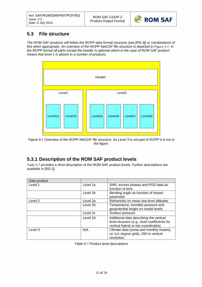
5.3 File structure
The ROM SAF products will follow the ROPP data format structure (see [RD.3]) or combinations of this when appropriate. An overview of the ROPP NetCDF file structure is depicted in Figure 5-1. In the ROPP format all parts except the header is optional which in the case of ROM SAF product means that level 1 is absent in a number of products.
Header
Level1 Level2
Level1a Level1b Level2a Level2b Level2c Level2d
Figure 5-1 Overview of the ROPP NetCDF file structure. As Level 3 is not part of ROPP it is not in
the figure.
5.3.1 Description of the ROM SAF product levels Table 5-7 provides a short description of the ROM SAF product levels. Further descriptions are available in [RD.3]. Data product Level 1 Level 1a SNR, excess phases and POD data as
function of time Level 1b Bending angle as function of impact
parameter Level 2 Level 2a Refractivity on mean sea level altitudes Level 2b Temperature, humidity pressure and
geopotential height on model levels Level 2c Surface pressure Level 2d Additional data describing the vertical
level structure (e.g., level coefficients for vertical hybrid or eta–coordinates)
Level 3 N/A Climate data (zonal and monthly means), on 1x1 degree grids, 200 m vertical resolution.
Table 5-7 Product level descriptions
Ref: SAF/ROM/DMI/FMT/POF/001 Issue: 2.2 Date: 9 July 2014
ROM SAF CDOP-2 Product Output Format
16 of 29
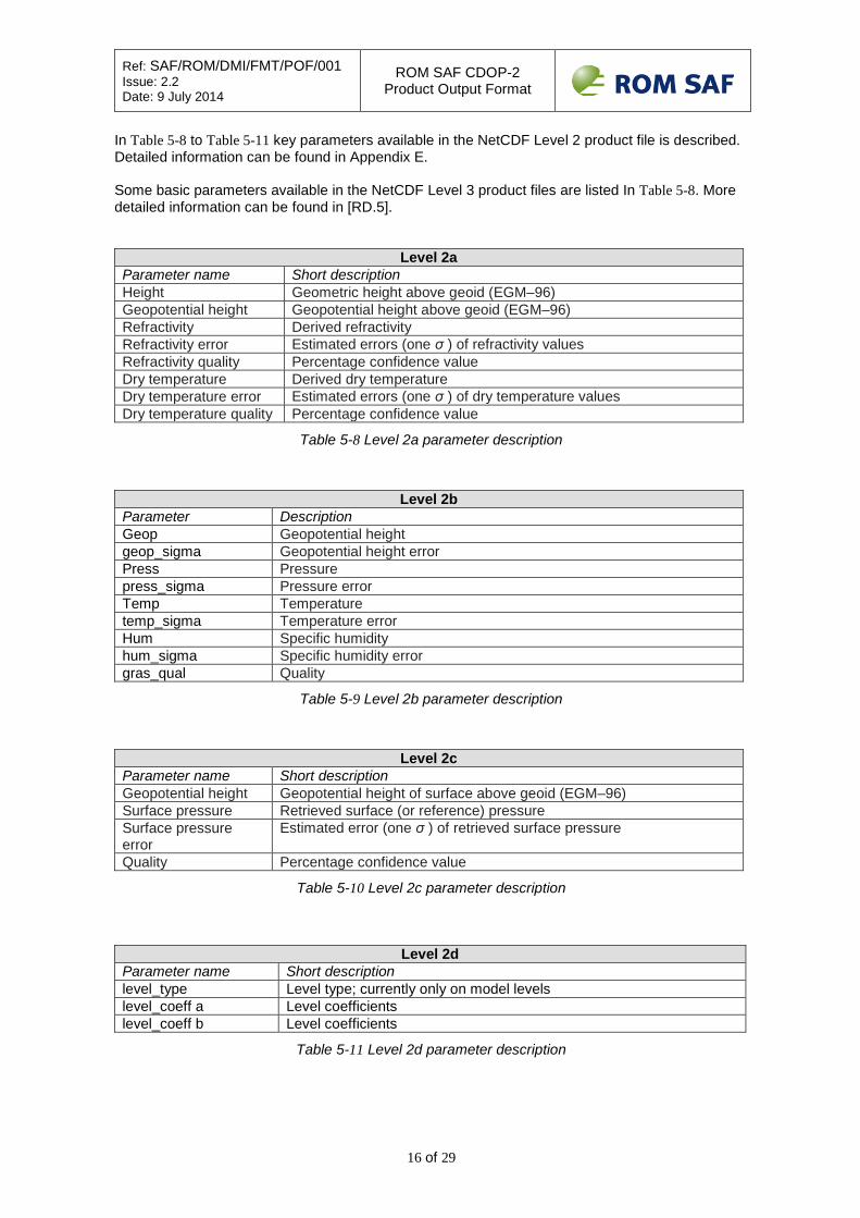
In Table 5-8 to Table 5-11 key parameters available in the NetCDF Level 2 product file is described. Detailed information can be found in Appendix E. Some basic parameters available in the NetCDF Level 3 product files are listed In Table 5-8. More detailed information can be found in [RD.5].
Level 2a Parameter name Short description Height Geometric height above geoid (EGM–96) Geopotential height Geopotential height above geoid (EGM–96) Refractivity Derived refractivity Refractivity error Estimated errors (one σ ) of refractivity values Refractivity quality Percentage confidence value Dry temperature Derived dry temperature Dry temperature error Estimated errors (one σ ) of dry temperature values Dry temperature quality Percentage confidence value
Table 5-8 Level 2a parameter description
Level 2b Parameter Description Geop Geopotential height geop_sigma Geopotential height error Press Pressure press_sigma Pressure error Temp Temperature temp_sigma Temperature error Hum Specific humidity hum_sigma Specific humidity error gras_qual Quality
Table 5-9 Level 2b parameter description
Level 2c Parameter name Short description Geopotential height Geopotential height of surface above geoid (EGM–96) Surface pressure Retrieved surface (or reference) pressure Surface pressure error
Estimated error (one σ ) of retrieved surface pressure
Quality Percentage confidence value
Table 5-10 Level 2c parameter description
Level 2d Parameter name Short description level_type Level type; currently only on model levels level_coeff a Level coefficients level_coeff b Level coefficients
Table 5-11 Level 2d parameter description

Ref: SAF/ROM/DMI/FMT/POF/001 Issue: 2.2 Date: 9 July 2014
ROM SAF CDOP-2 Product Output Format
17 of 29
Level 3
Parameter name Short description BEN Bending angle monthly mean BEN_stdev Bending angle monthly standard deviation BEN_obssig Observational uncertainty of the monthly mean REF Refractivity monthly mean REF_stdev Refractivity monthly standard deviation REF_obssig Observational uncertainty of the mean T Temperature monthly mean T_stdev Temperature monthly standard deviation T_obssig Observational uncertainty of the monthly mean Q Specific humidity monthly mean Q_stdev Specific humidity monthly standard deviation Q_obssig Observational uncertainty of the mean GPH Geopotential height monthly mean GPH_stdev Geopotential height monthly standard deviation GPH_obssig Observational uncertainty of the mean
Table 5-12 Level 3 parameter description examples.
5.4 Dissemination Media
Products are disseminated using different media:
• GTS/RMDCN network and EUMETCast • Offline distribution to users (via e.g. Web, FTP, DVD’s).
The RMDCN Network is used for NRT products dissemination. The products that are distributed by each media are identified in appendix B.
5.4.1 Disseminated Products Format
5.4.2 RMDCN Network The current baseline for the near real-time distribution of ROM SAF products to the National Meteorological Services (NMS’s) of EUMETSAT Member States and Co-operating States is to use the Regional Meteorological Data Communication Network (RMDCN). This requires the ROM SAF products to be compliant with the World Meteorological Organisation (WMO) standard binary format, the BUFR format. A specification which allows encoding of radio occultation data into BUFR format is ratified by WMO and allows for GTS dissemination. See [AD.3] for format descriptions on this data type.
5.4.3 EUMETCast The NRT data will be disseminated via EUMETCast as well. This data will be formatted in the NetCDF format, see [AD.3]. The dissemination will be done by uploading data to the EUMETCast dissemination ftp server.
Ref: SAF/ROM/DMI/FMT/POF/001 Issue: 2.2 Date: 9 July 2014
ROM SAF CDOP-2 Product Output Format
18 of 29
5.4.4 Offline Distribution The off-line distribution will be via Web, FTP and DVD’s. This data delivery will be serviced over the internet, not over specialized, guaranteed performance operational lines. The users will be given several options as for the reception channel for the data. Unlike NRT products, which will be actively broadcasted, offline products will be passively made available at the website archive for retrieval.
Ref: SAF/ROM/DMI/FMT/POF/001 Issue: 2.2 Date: 9 July 2014
ROM SAF CDOP-2 Product Output Format
19 of 29
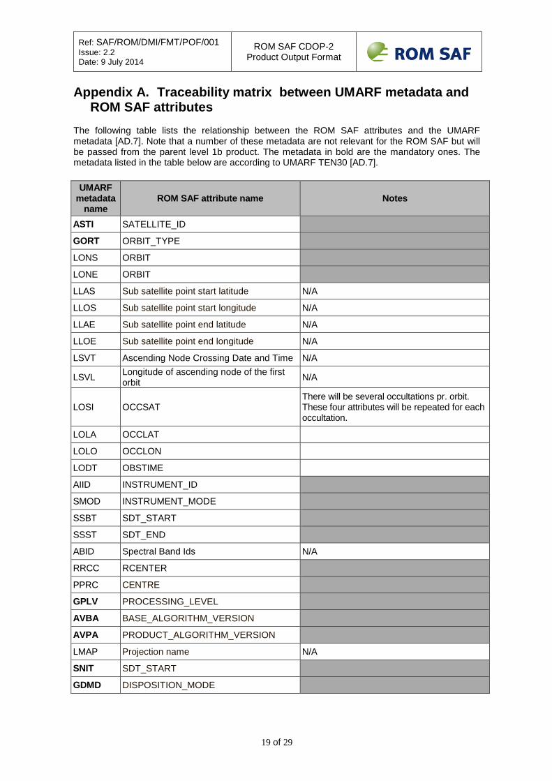
Appendix A. Traceability matrix between UMARF metadata and ROM SAF attributes
The following table lists the relationship between the ROM SAF attributes and the UMARF metadata [AD.7]. Note that a number of these metadata are not relevant for the ROM SAF but will be passed from the parent level 1b product. The metadata in bold are the mandatory ones. The metadata listed in the table below are according to UMARF TEN30 [AD.7].
UMARF metadata
name ROM SAF attribute name Notes
ASTI SATELLITE_ID
GORT ORBIT_TYPE
LONS ORBIT
LONE ORBIT
LLAS Sub satellite point start latitude N/A
LLOS Sub satellite point start longitude N/A
LLAE Sub satellite point end latitude N/A
LLOE Sub satellite point end longitude N/A
LSVT Ascending Node Crossing Date and Time N/A
LSVL Longitude of ascending node of the first orbit N/A
LOSI OCCSAT There will be several occultations pr. orbit. These four attributes will be repeated for each occultation.
LOLA OCCLAT LOLO OCCLON LODT OBSTIME AIID INSTRUMENT_ID
SMOD INSTRUMENT_MODE
SSBT SDT_START
SSST SDT_END
ABID Spectral Band Ids N/A
RRCC RCENTER
PPRC CENTRE
GPLV PROCESSING_LEVEL
AVBA BASE_ALGORITHM_VERSION
AVPA PRODUCT_ALGORITHM_VERSION
LMAP Projection name N/A
SNIT SDT_START
GDMD DISPOSITION_MODE
Ref: SAF/ROM/DMI/FMT/POF/001 Issue: 2.2 Date: 9 July 2014
ROM SAF CDOP-2 Product Output Format
20 of 29
UMARF metadata
name ROM SAF attribute name Notes
GPMD PROCESSING_MODE
APNM TYPE
APNA PRODUCT
APPN PPRDID
AAST Statistic Type N/A
AAAR Time Range N/A
APAS PRDSZ
GNFV NATIVE_PRODUCT_FORMAT_VERSION
QCCV Cloud coverage N/A
QQOV QUALITY
QQAI AQUALITY
QDRC Degraded Record Count N/A
QDRP Degraded Record Percentage N/A
QDLC Missing Data Records N/A
QDLP Missing Data Percentage N/A
AARF ARCHIVE
GGTP GRANULE_TYPE
UMARF metadata to ROM SAF attributes traceability matrix
Ref: SAF/ROM/DMI/FMT/POF/001 Issue: 2.2 Date: 9 July 2014
ROM SAF CDOP-2 Product Output Format
21 of 29
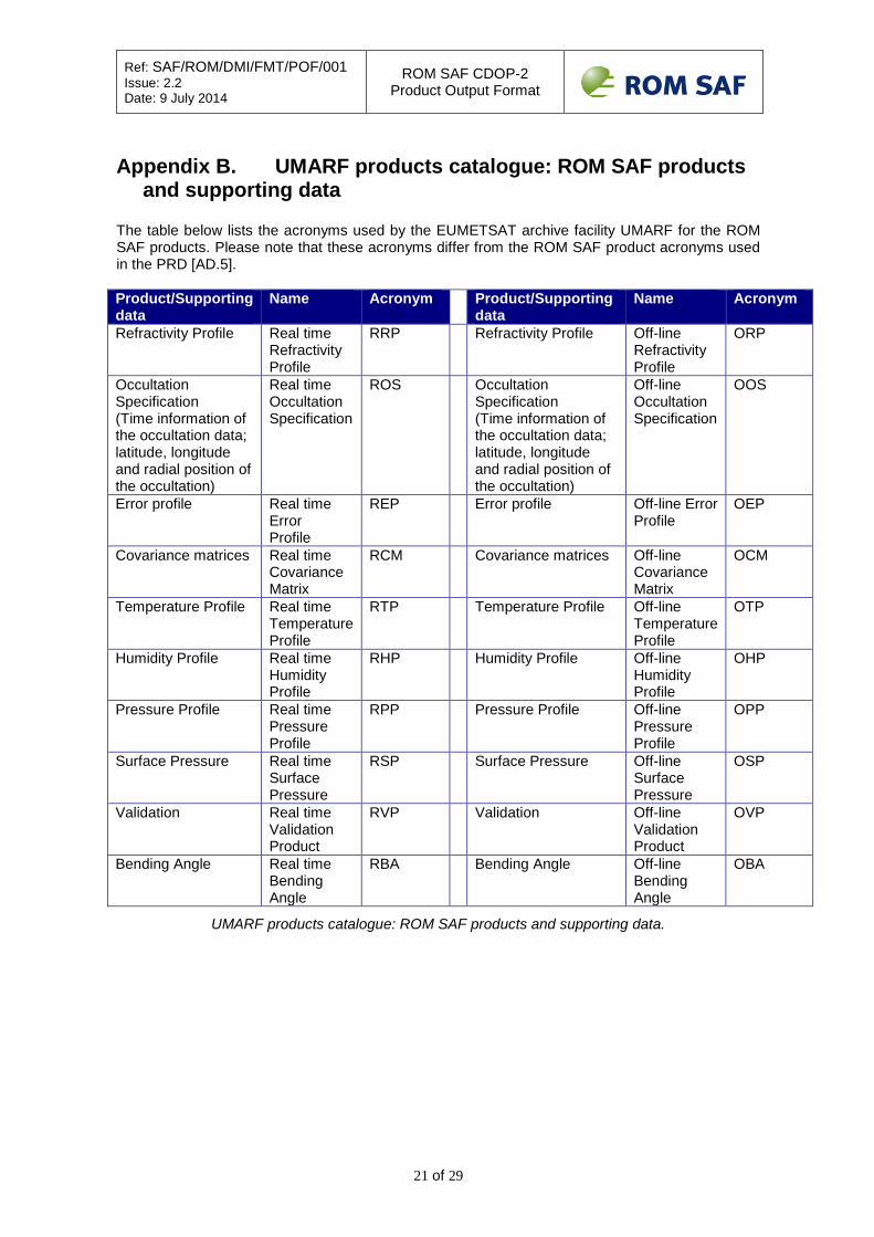
Appendix B. UMARF products catalogue: ROM SAF products
and supporting data The table below lists the acronyms used by the EUMETSAT archive facility UMARF for the ROM SAF products. Please note that these acronyms differ from the ROM SAF product acronyms used in the PRD [AD.5]. Product/Supporting data
Name Acronym Product/Supporting data
Name Acronym
Refractivity Profile Real time Refractivity Profile
RRP Refractivity Profile Off-line Refractivity Profile
ORP
Occultation Specification (Time information of the occultation data; latitude, longitude and radial position of the occultation)
Real time Occultation Specification
ROS Occultation Specification (Time information of the occultation data; latitude, longitude and radial position of the occultation)
Off-line Occultation Specification
OOS
Error profile Real time Error Profile
REP Error profile Off-line Error Profile
OEP
Covariance matrices Real time Covariance Matrix
RCM Covariance matrices Off-line Covariance Matrix
OCM
Temperature Profile Real time Temperature Profile
RTP Temperature Profile Off-line Temperature Profile
OTP
Humidity Profile Real time Humidity Profile
RHP Humidity Profile Off-line Humidity Profile
OHP
Pressure Profile Real time Pressure Profile
RPP Pressure Profile Off-line Pressure Profile
OPP
Surface Pressure Real time Surface Pressure
RSP Surface Pressure Off-line Surface Pressure
OSP
Validation Real time Validation Product
RVP Validation Off-line Validation Product
OVP
Bending Angle Real time Bending Angle
RBA Bending Angle Off-line Bending Angle
OBA
UMARF products catalogue: ROM SAF products and supporting data.
Ref: SAF/ROM/DMI/FMT/POF/001 Issue: 2.2 Date: 9 July 2014
ROM SAF CDOP-2 Product Output Format
22 of 29
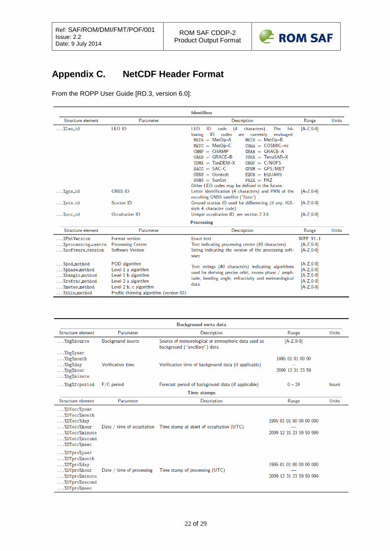
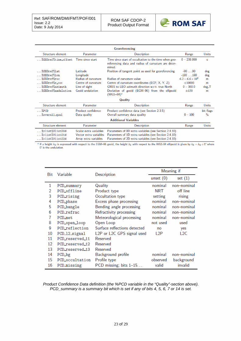
Appendix C. NetCDF Header Format From the ROPP User Guide [RD.3, version 6.0]:
Ref: SAF/ROM/DMI/FMT/POF/001 Issue: 2.2 Date: 9 July 2014
ROM SAF CDOP-2 Product Output Format
23 of 29
Product Confidence Data definition (the %PCD variable in the “Quality”-section above). PCD_summary is a summary bit which is set if any of bits 4, 5, 6, 7 or 14 is set.

Ref: SAF/ROM/DMI/FMT/POF/001 Issue: 2.2 Date: 9 July 2014
ROM SAF CDOP-2 Product Output Format
24 of 29
Appendix D. Level 1 Data NetCDF Formats From the ROPP User Guide [RD.3, version 6.0]:

Ref: SAF/ROM/DMI/FMT/POF/001 Issue: 2.2 Date: 9 July 2014
ROM SAF CDOP-2 Product Output Format
25 of 29
Appendix E. Level 2 Data NetCDF Formats From the ROPP User guide [RD.3, version 6.0]:

Ref: SAF/ROM/DMI/FMT/POF/001 Issue: 2.2 Date: 9 July 2014
ROM SAF CDOP-2 Product Output Format
26 of 29
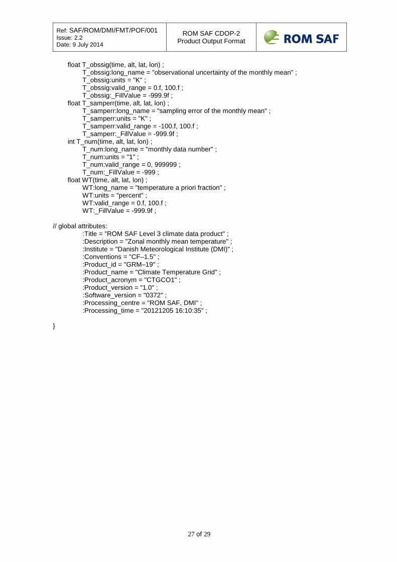
Appendix F. Level 3 Data NetCDF Formats The following is adapted from [RD.5]. The data format for the ROM SAF Level 3 data products is netCDF. There are two types of netCDF files related to the Level 3 data products: zgrid files holding the zonal monthly means and trace files holding the associated meta-data. zgrid files The zgrid files have the following structure, exemplified by a dump from the file zgrid_ctgco1_cosmic_201101_O_0372_0010.nc holding monthly mean temperatures based on COSMIC data in January 2011: netcdf zgrid_ctgco1_cosmic_201101_O_0372_0010 { dimensions: time = UNLIMITED ; // (1 currently) lon = 1 ; lat = 36 ; alt = 201 ; C64 = 64 ; variables: char mission(C64) ; mission:long_name = "mission/satellite" ; int year(time) ; year:valid_range = 1995, 2099 ; year:_FillValue = -9999 ; int month(time) ; month:valid_range = 1, 12 ; month:_FillValue = -99 ; float lon(lon) ; lon:long_name = "longitude" ; lon:units = "degrees_east" ; lon:valid_range = 0.f, 360.f ; float lat(lat) ; lat:long_name = "latitude" ; lat:units = "degrees_north" ; lat:valid_range = -90.f, 90.f ; float alt(alt) ; alt:long_name = "MSL altitude" ; alt:units = "m" ; alt:valid_range = -1000.f, 100000.f ; float T(time, alt, lat, lon) ; T:long_name = "temperature monthly mean" ; T:units = "K" ; T:valid_range = 150.f, 350.f ; T:_FillValue = -999.9f ; float T_stdev(time, alt, lat, lon) ; T_stdev:long_name = "temperature monthly standard deviation" ; T_stdev:units = "K" ; T_stdev:valid_range = 0.f, 100.f ; T_stdev:_FillValue = -999.9f ;
Ref: SAF/ROM/DMI/FMT/POF/001 Issue: 2.2 Date: 9 July 2014
ROM SAF CDOP-2 Product Output Format
27 of 29
float T_obssig(time, alt, lat, lon) ; T_obssig:long_name = "observational uncertainty of the monthly mean" ; T_obssig:units = "K" ; T_obssig:valid_range = 0.f, 100.f ; T_obssig:_FillValue = -999.9f ; float T_samperr(time, alt, lat, lon) ; T_samperr:long_name = "sampling error of the monthly mean" ; T_samperr:units = "K" ; T_samperr:valid_range = -100.f, 100.f ; T_samperr:_FillValue = -999.9f ; int T_num(time, alt, lat, lon) ; T_num:long_name = "monthly data number" ; T_num:units = "1" ; T_num:valid_range = 0, 999999 ; T_num:_FillValue = -999 ; float WT(time, alt, lat, lon) ; WT:long_name = "temperature a priori fraction" ; WT:units = "percent" ; WT:valid_range = 0.f, 100.f ; WT:_FillValue = -999.9f ; // global attributes: :Title = "ROM SAF Level 3 climate data product" ; :Description = "Zonal monthly mean temperature" ; :Institute = "Danish Meteorological Institute (DMI)" ; :Conventions = "CF–1.5" ; :Product_id = "GRM–19" ; :Product_name = "Climate Temperature Grid" ; :Product_acronym = "CTGCO1" ; :Product_version = "1.0" ; :Software_version = "0372" ; :Processing_centre = "ROM SAF, DMI" ; :Processing_time = "20121205 16:10:35" ; }

Ref: SAF/ROM/DMI/FMT/POF/001 Issue: 2.2 Date: 9 July 2014
ROM SAF CDOP-2 Product Output Format
28 of 29
trace files The trace files have the following structure, exemplified by a dump from the file trace_ctgco1_cosmic_201101_O_0372_0010.nc holding the meta-data associated with the file referred to for the zgrid file above: netcdf trace_ctgco1_COSMIC_201101_O_0021_0010 { dimensions: dimtime = UNLIMITED ; // (1 currently) dimocc = 29604 ; dimC04 = 4 ; dimC40 = 40 ; dimC64 = 64 ; variables: char mission(dimC64) ; mission:long_name = "Mission/satellites" ; int year(dimtime) ; year:long_name = "Year" ; year:valid_range = 1995, 2099 ; year:_FillValue = -9999 ; int month(dimtime) ; month:long_name = "Month" ; month:valid_range = 1, 12 ; month:_FillValue = -99 ; char occ_id(dimtime, dimocc, dimC40) ; occ_id:long_name = "Occultation ID" ; char leo_id(dimtime, dimocc, dimC04) ; leo_id:long_name = "LEO satellite ID" ; char gns_id(dimtime, dimocc, dimC04) ; gns_id:long_name = "GNSS satellite ID" ; char stn_id(dimtime, dimocc, dimC04) ; stn_id:long_name = "Ground station ID" ; int day(dimtime, dimocc) ; day:long_name = "Day" ; day:valid_range = 1, 31 ; day:_FillValue = -99 ; int hour(dimtime, dimocc) ; hour:long_name = "Hour" ; hour:valid_range = 0, 23 ; hour:_FillValue = -99 ; int mnt(dimtime, dimocc) ; mnt:long_name = "Minute" ; mnt:valid_range = 0, 59 ; mnt:_FillValue = -99 ; int sec(dimtime, dimocc) ; sec:long_name = "Second" ; sec:valid_range = 0, 59 ; sec:_FillValue = -99 ; float lon(dimtime, dimocc) ; lon:long_name = "Nominal longitude" ; lon:units = "degrees_east" ; lon:valid_range = 0.f, 360.f ;
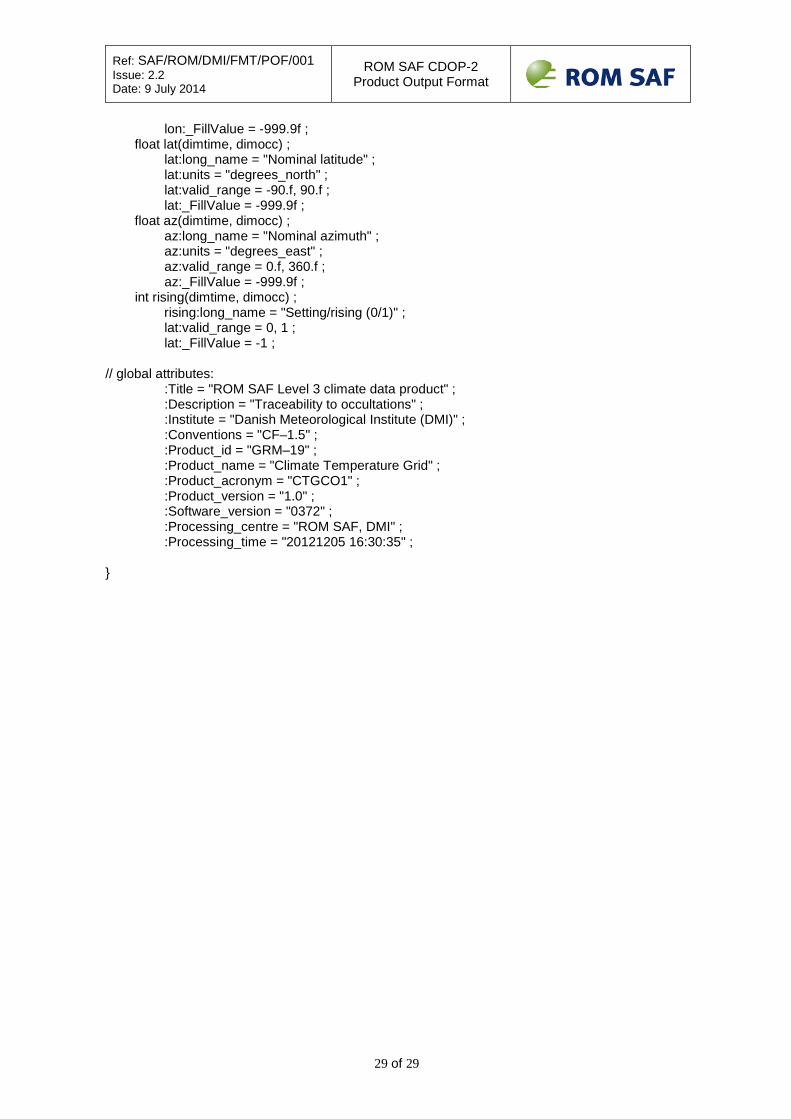
Ref: SAF/ROM/DMI/FMT/POF/001 Issue: 2.2 Date: 9 July 2014
ROM SAF CDOP-2 Product Output Format
29 of 29
lon:_FillValue = -999.9f ; float lat(dimtime, dimocc) ; lat:long_name = "Nominal latitude" ; lat:units = "degrees_north" ; lat:valid_range = -90.f, 90.f ; lat:_FillValue = -999.9f ; float az(dimtime, dimocc) ; az:long_name = "Nominal azimuth" ; az:units = "degrees_east" ; az:valid_range = 0.f, 360.f ; az:_FillValue = -999.9f ; int rising(dimtime, dimocc) ; rising:long_name = "Setting/rising (0/1)" ; lat:valid_range = 0, 1 ; lat:_FillValue = -1 ; // global attributes: :Title = "ROM SAF Level 3 climate data product" ; :Description = "Traceability to occultations" ; :Institute = "Danish Meteorological Institute (DMI)" ; :Conventions = "CF–1.5" ; :Product_id = "GRM–19" ; :Product_name = "Climate Temperature Grid" ; :Product_acronym = "CTGCO1" ; :Product_version = "1.0" ; :Software_version = "0372" ; :Processing_centre = "ROM SAF, DMI" ; :Processing_time = "20121205 16:30:35" ; }


![GRAS SAF CDOP - ROM SAF · 18/04/2008 · 1. Introduction The purpose of this study was to use data from the German CHAMP (CHAllenging Minisatel-lite Payload, Reigber et al. [2005]](https://static.fdocuments.net/doc/165x107/5f3dba986e6a3e29d42628e5/gras-saf-cdop-rom-saf-18042008-1-introduction-the-purpose-of-this-study.jpg)