Role of glaciers in watershed hydrology: a - The Cryosphere
14
The Cryosphere, 4, 115–128, 2010 www.the-cryosphere.net/4/115/2010/ © Author(s) 2010. This work is distributed under the Creative Commons Attribution 3.0 License. The Cryosphere Role of glaciers in watershed hydrology: a preliminary study of a “Himalayan catchment” R. J. Thayyen 1,2 and J. T. Gergan 1 1 Wadia Institute of Himalayan Geology, 33-GMS Road, Dehradun 248001, India 2 National Institute of Hydrology, Western Himalayan Regional centre, Jammu 180003, India Received: 22 June 2009 – Published in The Cryosphere Discuss.: 15 July 2009 Revised: 1 February 2010 – Accepted: 3 February 2010 – Published: 9 February 2010 Abstract. A large number of Himalayan glacier catch- ments are under the influence of humid climate with snow- fall in winter (November–April) and south-west monsoon in summer (June–September) dominating the regional hydrol- ogy. Such catchments are defined as “Himalayan catch- ment”, where the glacier meltwater contributes to the river flow during the period of annual high flows produced by the monsoon. The winter snow dominated Alpine catchments of the Kashmir and Karakoram region and cold-arid regions of the Ladakh mountain range are the other major glacio- hydrological regimes identified in the region. Factors in- fluencing the river flow variations in a “Himalayan catch- ment” were studied in a micro-scale glacier catchment in the Garhwal Himalaya, covering an area of 77.8 km 2 . Three hydrometric stations were established at different altitudes along the Din Gad stream and discharge was monitored dur- ing the summer ablation period from 1998 to 2004, with an exception in 2002. These data have been analysed along with winter/summer precipitation, temperature and mass bal- ance data of the Dokriani glacier to study the role of glacier and precipitation in determining runoff variations along the stream continuum from the glacier snout to 2360 m a.s.l. The study shows that the inter-annual runoff variation in a “Hi- malayan catchment” is linked with precipitation rather than mass balance changes of the glacier. This study also indicates that the warming induced an initial increase of glacier runoff and subsequent decline as suggested by the IPCC (2007) is restricted to the glacier degradation-derived component in a precipitation dominant Himalayan catchment and cannot be translated as river flow response. The preliminary assessment suggests that the “Himalayan catchment” could experience Correspondence to: R. J. Thayyen ([email protected]) higher river flows and positive glacier mass balance regime together in association with strong monsoon. The important role of glaciers in this precipitation dominant system is to augment stream runoff during the years of low summer dis- charge. This paper intends to highlight the importance of creating credible knowledge on the Himalayan cryospheric processes to develop a more representative global view on river flow response to cryospheric changes and locally sus- tainable water resources management strategies. 1 Introduction The role of high mountain areas of the world as an important source of freshwater for the population living in the adja- cent lowlands has been highlighted by recent studies (Bandy- opadhyay et al., 1997; Viviroli and Weingartner, 2004; Bar- nett et al., 2005; Viviroli et al., 2007). The Himalaya is one of the focal regions, both in terms of its cryospheric re- sources and the dependency of a huge population on rivers originating from this mighty mountain chain. The Himalaya nourish more than 12 000 glaciers (Kaul, 1999; ICIMOD, 2001) covering an area of about 33 000 km 2 (Rai and Gu- rung, 2005). River Ganga is being replenished by the melt- water from around 4000 glaciers spread over India and Nepal and River Indus is being fed by more than 3300 glaciers. Snow and glacier melt together with monsoonal precipita- tion determines the headwater flow regimes of large parts of the Himalayas, including central and eastern Himalayan trib- utaries of River Ganga and Brahmaputra. Snow and glacier melt contribution are very significant in many of these Hi- malayan rivers. On average, the annual snow and glacier melt contribution is estimated to be 60% in Satluj river at Bhakra dam (Singh and Jain, 2002), 49% in Chenab river at Published by Copernicus Publications on behalf of the European Geosciences Union.
Transcript of Role of glaciers in watershed hydrology: a - The Cryosphere

The Cryosphere, 4, 115–128, 2010www.the-cryosphere.net/4/115/2010/© Author(s) 2010. This work is distributed underthe Creative Commons Attribution 3.0 License.
The Cryosphere
Role of glaciers in watershed hydrology: a preliminary study of a“Himalayan catchment”
R. J. Thayyen1,2 and J. T. Gergan1
1Wadia Institute of Himalayan Geology, 33-GMS Road, Dehradun 248001, India2National Institute of Hydrology, Western Himalayan Regional centre, Jammu 180003, India
Received: 22 June 2009 – Published in The Cryosphere Discuss.: 15 July 2009Revised: 1 February 2010 – Accepted: 3 February 2010 – Published: 9 February 2010
Abstract. A large number of Himalayan glacier catch-ments are under the influence of humid climate with snow-fall in winter (November–April) and south-west monsoon insummer (June–September) dominating the regional hydrol-ogy. Such catchments are defined as “Himalayan catch-ment”, where the glacier meltwater contributes to the riverflow during the period of annual high flows produced by themonsoon. The winter snow dominated Alpine catchmentsof the Kashmir and Karakoram region and cold-arid regionsof the Ladakh mountain range are the other major glacio-hydrological regimes identified in the region. Factors in-fluencing the river flow variations in a “Himalayan catch-ment” were studied in a micro-scale glacier catchment inthe Garhwal Himalaya, covering an area of 77.8 km2. Threehydrometric stations were established at different altitudesalong the Din Gad stream and discharge was monitored dur-ing the summer ablation period from 1998 to 2004, with anexception in 2002. These data have been analysed alongwith winter/summer precipitation, temperature and mass bal-ance data of the Dokriani glacier to study the role of glacierand precipitation in determining runoff variations along thestream continuum from the glacier snout to 2360 m a.s.l. Thestudy shows that the inter-annual runoff variation in a “Hi-malayan catchment” is linked with precipitation rather thanmass balance changes of the glacier. This study also indicatesthat the warming induced an initial increase of glacier runoffand subsequent decline as suggested by the IPCC (2007) isrestricted to the glacier degradation-derived component in aprecipitation dominant Himalayan catchment and cannot betranslated as river flow response. The preliminary assessmentsuggests that the “Himalayan catchment” could experience
Correspondence to:R. J. Thayyen([email protected])
higher river flows and positive glacier mass balance regimetogether in association with strong monsoon. The importantrole of glaciers in this precipitation dominant system is toaugment stream runoff during the years of low summer dis-charge. This paper intends to highlight the importance ofcreating credible knowledge on the Himalayan cryosphericprocesses to develop a more representative global view onriver flow response to cryospheric changes and locally sus-tainable water resources management strategies.
1 Introduction
The role of high mountain areas of the world as an importantsource of freshwater for the population living in the adja-cent lowlands has been highlighted by recent studies (Bandy-opadhyay et al., 1997; Viviroli and Weingartner, 2004; Bar-nett et al., 2005; Viviroli et al., 2007). The Himalaya isone of the focal regions, both in terms of its cryospheric re-sources and the dependency of a huge population on riversoriginating from this mighty mountain chain. The Himalayanourish more than 12 000 glaciers (Kaul, 1999; ICIMOD,2001) covering an area of about 33 000 km2 (Rai and Gu-rung, 2005). River Ganga is being replenished by the melt-water from around 4000 glaciers spread over India and Nepaland River Indus is being fed by more than 3300 glaciers.Snow and glacier melt together with monsoonal precipita-tion determines the headwater flow regimes of large parts ofthe Himalayas, including central and eastern Himalayan trib-utaries of River Ganga and Brahmaputra. Snow and glaciermelt contribution are very significant in many of these Hi-malayan rivers. On average, the annual snow and glaciermelt contribution is estimated to be 60% in Satluj river atBhakra dam (Singh and Jain, 2002), 49% in Chenab river at
Published by Copernicus Publications on behalf of the European Geosciences Union.

116 R. J. Thayyen and J. T. Gergan: Role of glaciers in watershed hydrology
Akhnoor (Singh et al., 1997) and 35% in Beas river at Pandoh(Kumar et al., 2007). The Himalayan cryospheric system, thelargest outside the polar region, has a number of hydrologicaland climatic regimes, extending from the cold-arid regions ofLadakh to the humid monsoon climate of the north-easternHimalayas (Mani, 1981). Glaciers in these regions are in ageneral state of recession since the 1850’s (Mayewski andJeschke, 1979; Vohra, 1981; Dobhal et al., 2004; Kulkarniet al., 2007) with a few exceptions in the Karakoram region,which are advancing (Hewitt, 2005). As these glaciers con-tinue to recede, its impact on major glacier-fed rivers in theregion is a matter of grave concern. The present understand-ing regarding the impact of glacier shrinkage on river flowvariations has been discussed by the IPCC (2007a) whichstated that “as these glaciers retreat due to global warming,river flows are increased in the short term, but the contribu-tion of glacier melt will gradually decrease over the next fewdecades” and that “the enhanced melting of glaciers leadsat first to increased river runoff and discharge peaks and anincreased melt season” (IPCC, 2007b). However, consider-ing the diverse climatic and hydrological regime of mountainglaciers across the world, such a uniform river flow responseto glacier melting needs further evaluation. The Himalayanregion has three dominant climatological regimes, which in-clude areas experiencing monsoon and winter precipitation,areas dominated by winter precipitation from western dis-turbances and cold-arid regions (Vohra, 1981). Therefore,a glacier’s role in influencing the flow regimes of moun-tain rivers across the Himalayan arc would vary considerably.The Dokriani glacier in the Ganga basin is one of the moststudied glaciers in the Indian Himalaya and various facetsof glacio-hydrological processes have been investigated ear-lier (Singh et al., 1995; Hasnain and Thayyen, 1999a, b;Hasnain, 1999; Thayyen et al.,1999, 2003, 2005a, b, 2009;Singh et al., 2000a, b, 2003a, b; Nijampurkar et al., 2002;Dobhal et al., 2004, 2008). In this work, an attempt hasbeen made to highlight the fundamental differences betweenAlpine and Himalayan glacier hydrological systems and therole of glaciers in influencing runoff characteristics of mon-soon dominated “Himalayan catchments”.
2 Methods
2.1 Study area
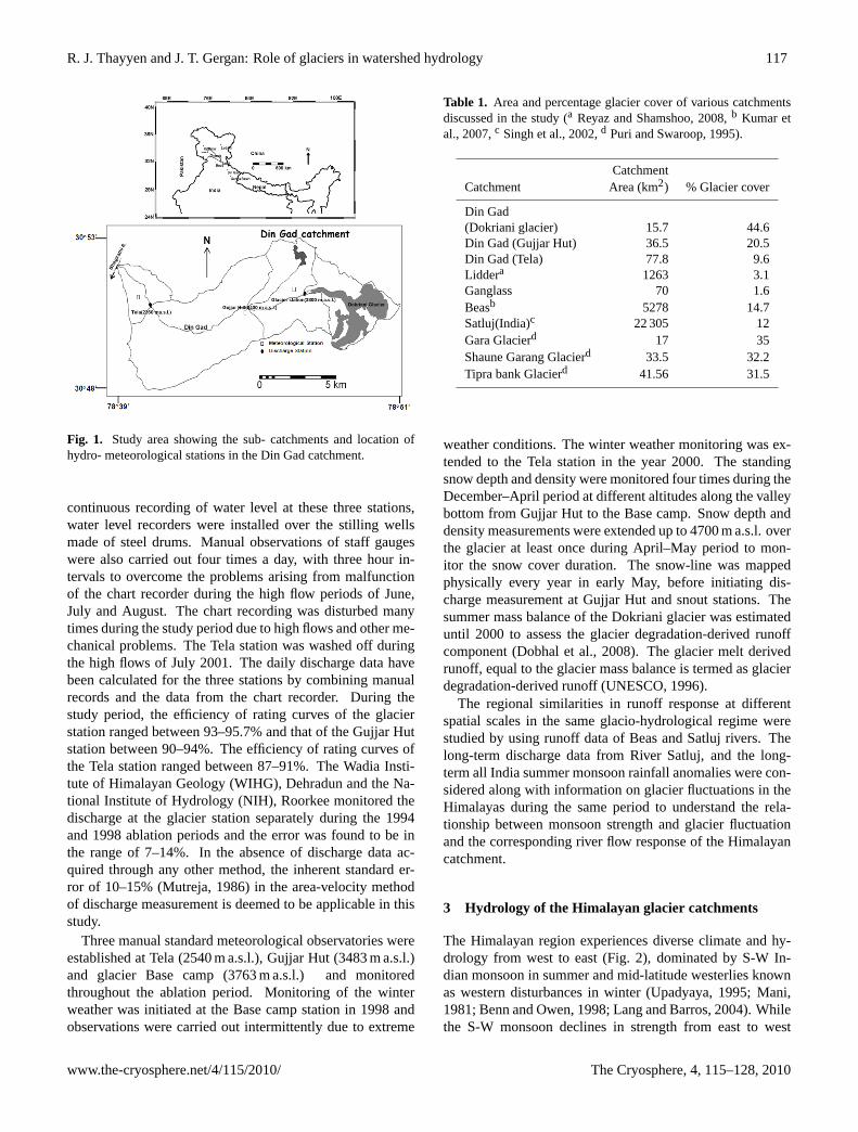
This study focuses on the “Himalayan catchments” of theWestern Himalayan region, mainly on the Din Gad catch-ment in the Ganga basin. The basin-scale response of riverflow during the past years has been studied in the nearbySatluj and Beas basins which extend from 30◦48′ to 32◦26′ Nand 76◦58′ to 78◦51′ E. The Din Gad catchment covers anarea of 77.8 km2, extends from 2360 to 6000 m a.s.l. and has9.6% glacierisation. The general aspect of this valley is NWwhich lies between latitude 30◦48′ to 30◦53′ N and longitude
78◦39′ to 78◦51′ E. Din Gad is the pro-glacial stream of theDokriani glacier which joins Bhagirathi river near Bhukkivillage (Fig. 1). The length of the Dokriani glacier is 5.5 kmand covers an area of 7 km2. This glacier has receded 726 min 43 years (1962–2005) with an average rate of 16.8 m/yrand has lost approximately 22% of its volume from the totalstorage of 385×106 m3 (Dobhal et al., 2004). The averageaccumulation rate of this glacier is 0.43 my−1 (Dobhal et al.,2007; Nijampurkar et al., 2002), with an average accumu-lation area ratio (AAR) of 0.66. Another small glacier withan area of 0.46 km2 is also part of the Din Gad catchment,and its pro-glacial stream joins Din Gad at 3400 m a.s.l. justabove the Gujjar Hut hydrometric station.
The Satluj basin lies north-west of the Ganga basin and theriver flows down from China to India. The Indian part of theSatluj basin covers an area of 22 275 km2 and 12% of the areais covered by glaciers and permanent snowfields and approx-imately 65% of the area receives winter snowfall (Singh andJain, 2002). The Beas catchment shares its western bound-ary with the Satluj basin and has an area of 5278 km2 with780 km2 (14.7%) of glaciers and perennial snow cover (Ku-mar et al., 2007). The area and percentage glacier cover ofvarious catchments discussed in this study are given in Ta-ble 1.
2.2 Data collection
The main objective of glaciological studies in the Himalayais to generate a knowledge base for managing the large frozenwater reserves of glaciers and study the river flow responseto the fluctuations of glaciers and snow cover (Thayyen etal., 2007a). Following the Alpine format, glaciological stud-ies were focused on glacier mass balance, glacier dischargeand monitoring of the meteorological parameters close to theglacier. The role of monsoons and snow cover has receivedlittle attention in the glaciological study frame-work, andover the years it has been found that the approach has failedin achieving the desired result of understanding river flow re-sponse to cryospheric changes. To better understand the im-pact of monsoon and western disturbances on glacier regimesas well as on the runoff from the catchment, three hydromet-ric and meteorological stations, covering different altitudinalzones of the Din Gad catchment were established in 1998(Fig. 1). This approach enabled us to monitor the runoff vari-ability all along the stream continuum, from the glacier portal(3900 m a.s.l.) to 2360 m a.s.l. The first discharge station wasestablished at 600 m downstream from the glacier snout at3800 m a.s.l. The second station at Gujjar Hut (3400 m a.s.l.)covered the snow dominated Alpine meadows and the thirdstation at Tela (2360 m a.s.l.) covered the highly forested,monsoon dominated lower part of the catchment. These sta-tions were monitored throughout the ablation season from15 May to 31 October during the 1998–2004 periods, withan exception in 2002. The discharge was calculated froma rating curve established by the area-velocity method. For
The Cryosphere, 4, 115–128, 2010 www.the-cryosphere.net/4/115/2010/
R. J. Thayyen and J. T. Gergan: Role of glaciers in watershed hydrology 117
31
Fig. 1. Study area showing the sub- catchments and location of hydro- meteorological stations in the Din Gad catchment. Fig. 1. Study area showing the sub- catchments and location ofhydro- meteorological stations in the Din Gad catchment.
continuous recording of water level at these three stations,water level recorders were installed over the stilling wellsmade of steel drums. Manual observations of staff gaugeswere also carried out four times a day, with three hour in-tervals to overcome the problems arising from malfunctionof the chart recorder during the high flow periods of June,July and August. The chart recording was disturbed manytimes during the study period due to high flows and other me-chanical problems. The Tela station was washed off duringthe high flows of July 2001. The daily discharge data havebeen calculated for the three stations by combining manualrecords and the data from the chart recorder. During thestudy period, the efficiency of rating curves of the glacierstation ranged between 93–95.7% and that of the Gujjar Hutstation between 90–94%. The efficiency of rating curves ofthe Tela station ranged between 87–91%. The Wadia Insti-tute of Himalayan Geology (WIHG), Dehradun and the Na-tional Institute of Hydrology (NIH), Roorkee monitored thedischarge at the glacier station separately during the 1994and 1998 ablation periods and the error was found to be inthe range of 7–14%. In the absence of discharge data ac-quired through any other method, the inherent standard er-ror of 10–15% (Mutreja, 1986) in the area-velocity methodof discharge measurement is deemed to be applicable in thisstudy.
Three manual standard meteorological observatories wereestablished at Tela (2540 m a.s.l.), Gujjar Hut (3483 m a.s.l.)and glacier Base camp (3763 m a.s.l.) and monitoredthroughout the ablation period. Monitoring of the winterweather was initiated at the Base camp station in 1998 andobservations were carried out intermittently due to extreme
Table 1. Area and percentage glacier cover of various catchmentsdiscussed in the study (a Reyaz and Shamshoo, 2008,b Kumar etal., 2007,c Singh et al., 2002,d Puri and Swaroop, 1995).
CatchmentCatchment Area (km2) % Glacier cover
Din Gad(Dokriani glacier) 15.7 44.6Din Gad (Gujjar Hut) 36.5 20.5Din Gad (Tela) 77.8 9.6Liddera 1263 3.1Ganglass 70 1.6Beasb 5278 14.7Satluj(India)c 22 305 12Gara Glacierd 17 35Shaune Garang Glacierd 33.5 32.2Tipra bank Glacierd 41.56 31.5
weather conditions. The winter weather monitoring was ex-tended to the Tela station in the year 2000. The standingsnow depth and density were monitored four times during theDecember–April period at different altitudes along the valleybottom from Gujjar Hut to the Base camp. Snow depth anddensity measurements were extended up to 4700 m a.s.l. overthe glacier at least once during April–May period to mon-itor the snow cover duration. The snow-line was mappedphysically every year in early May, before initiating dis-charge measurement at Gujjar Hut and snout stations. Thesummer mass balance of the Dokriani glacier was estimateduntil 2000 to assess the glacier degradation-derived runoffcomponent (Dobhal et al., 2008). The glacier melt derivedrunoff, equal to the glacier mass balance is termed as glacierdegradation-derived runoff (UNESCO, 1996).
The regional similarities in runoff response at differentspatial scales in the same glacio-hydrological regime werestudied by using runoff data of Beas and Satluj rivers. Thelong-term discharge data from River Satluj, and the long-term all India summer monsoon rainfall anomalies were con-sidered along with information on glacier fluctuations in theHimalayas during the same period to understand the rela-tionship between monsoon strength and glacier fluctuationand the corresponding river flow response of the Himalayancatchment.
3 Hydrology of the Himalayan glacier catchments
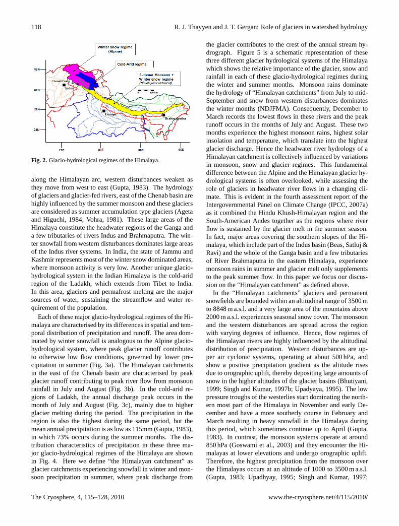
The Himalayan region experiences diverse climate and hy-drology from west to east (Fig. 2), dominated by S-W In-dian monsoon in summer and mid-latitude westerlies knownas western disturbances in winter (Upadyaya, 1995; Mani,1981; Benn and Owen, 1998; Lang and Barros, 2004). Whilethe S-W monsoon declines in strength from east to west
www.the-cryosphere.net/4/115/2010/ The Cryosphere, 4, 115–128, 2010
118 R. J. Thayyen and J. T. Gergan: Role of glaciers in watershed hydrology
32
Fig. 2. Glacio-hydrological regimes of the Himalaya
Fig. 2. Glacio-hydrological regimes of the Himalaya.
along the Himalayan arc, western disturbances weaken asthey move from west to east (Gupta, 1983). The hydrologyof glaciers and glacier-fed rivers, east of the Chenab basin arehighly influenced by the summer monsoon and these glaciersare considered as summer accumulation type glaciers (Agetaand Higuchi, 1984; Vohra, 1981). These large areas of theHimalaya constitute the headwater regions of the Ganga anda few tributaries of rivers Indus and Brahmaputra. The win-ter snowfall from western disturbances dominates large areasof the Indus river systems. In India, the state of Jammu andKashmir represents most of the winter snow dominated areas,where monsoon activity is very low. Another unique glacio-hydrological system in the Indian Himalaya is the cold-aridregion of the Ladakh, which extends from Tibet to India.In this area, glaciers and permafrost melting are the majorsources of water, sustaining the streamflow and water re-quirement of the population.
Each of these major glacio-hydrological regimes of the Hi-malaya are characterised by its differences in spatial and tem-poral distribution of precipitation and runoff. The area dom-inated by winter snowfall is analogous to the Alpine glacio-hydrological system, where peak glacier runoff contributesto otherwise low flow conditions, governed by lower pre-cipitation in summer (Fig. 3a). The Himalayan catchmentsin the east of the Chenab basin are characterised by peakglacier runoff contributing to peak river flow from monsoonrainfall in July and August (Fig. 3b). In the cold-arid re-gions of Ladakh, the annual discharge peak occurs in themonth of July and August (Fig. 3c), mainly due to higherglacier melting during the period. The precipitation in theregion is also the highest during the same period, but themean annual precipitation is as low as 115mm (Gupta, 1983),in which 73% occurs during the summer months. The dis-tribution characteristics of precipitation in these three ma-jor glacio-hydrological regimes of the Himalaya are shownin Fig. 4. Here we define “the Himalayan catchment” asglacier catchments experiencing snowfall in winter and mon-soon precipitation in summer, where peak discharge from
the glacier contributes to the crest of the annual stream hy-drograph. Figure 5 is a schematic representation of thesethree different glacier hydrological systems of the Himalayawhich shows the relative importance of the glacier, snow andrainfall in each of these glacio-hydrological regimes duringthe winter and summer months. Monsoon rains dominatethe hydrology of “Himalayan catchments” from July to mid-September and snow from western disturbances dominatesthe winter months (NDJFMA). Consequently, December toMarch records the lowest flows in these rivers and the peakrunoff occurs in the months of July and August. These twomonths experience the highest monsoon rains, highest solarinsolation and temperature, which translate into the highestglacier discharge. Hence the headwater river hydrology of aHimalayan catchment is collectively influenced by variationsin monsoon, snow and glacier regimes. This fundamentaldifference between the Alpine and the Himalayan glacier hy-drological systems is often overlooked, while assessing therole of glaciers in headwater river flows in a changing cli-mate. This is evident in the fourth assessment report of theIntergovernmental Panel on Climate Change (IPCC, 2007a)as it combined the Hindu Khush-Himalayan region and theSouth-American Andes together as the regions where riverflow is sustained by the glacier melt in the summer season.In fact, major areas covering the southern slopes of the Hi-malaya, which include part of the Indus basin (Beas, Satluj &Ravi) and the whole of the Ganga basin and a few tributariesof River Brahmaputra in the eastern Himalaya, experiencemonsoon rains in summer and glacier melt only supplementsto the peak summer flow. In this paper we focus our discus-sion on the “Himalayan catchment” as defined above.
In the “Himalayan catchments” glaciers and permanentsnowfields are bounded within an altitudinal range of 3500 mto 8848 m a.s.l. and a very large area of the mountains above2000 m a.s.l. experiences seasonal snow cover. The monsoonand the western disturbances are spread across the regionwith varying degrees of influence. Hence, flow regimes ofthe Himalayan rivers are highly influenced by the altitudinaldistribution of precipitation. Western disturbances are up-per air cyclonic systems, operating at about 500 hPa, andshow a positive precipitation gradient as the altitude risesdue to orographic uplift, thereby depositing large amounts ofsnow in the higher altitudes of the glacier basins (Bhutiyani,1999; Singh and Kumar, 1997b; Upadyaya, 1995). The lowpressure troughs of the westerlies start dominating the north-ern most part of the Himalaya in November and early De-cember and have a more southerly course in February andMarch resulting in heavy snowfall in the Himalaya duringthis period, which sometimes continue up to April (Gupta,1983). In contrast, the monsoon systems operate at around850 hPa (Goswami et al., 2003) and they encounter the Hi-malayas at lower elevations and undergo orographic uplift.Therefore, the highest precipitation from the monsoon overthe Himalayas occurs at an altitude of 1000 to 3500 m a.s.l.(Gupta, 1983; Upadhyay, 1995; Singh and Kumar, 1997;
The Cryosphere, 4, 115–128, 2010 www.the-cryosphere.net/4/115/2010/

R. J. Thayyen and J. T. Gergan: Role of glaciers in watershed hydrology 119
Role of glaciers in watershed hydrology: a preliminary study of a “Himalayan catchment” R. J. Thayyen and J. T. Gergan (tc-2009-10)
Corrections
Page 1 Line 6 Replace : 2National Institute of Hydrology, Western Himalayan Regional Centre, _India, too?
with
2 National Institute of Hydrology, Western Himalayan Regional centre, Jammu 180003, India
Page 5 Fig.3 : The axis titles of this figure look small after reducing its size. Please replace the figure with the following figure with enlarged axis titles.
Fig. 3. Temporal distribution of runoff and precipitation in glacio- hydrological regimes of the Himalaya in a mountain water year, showingcharacteristically different distribution pattern(A) snow dominant Alpine system, Lidder valley, Kashmir(B) monsoon dominant Himalayancatchment, Din Gad catchment, Ganga basin and(C) cold-arid system, Ganglass catchment, Ladakh range. Precipitation data are pointobservations made at lower part of the catchment.
34
Fig. 4. Figure showing comparative temporal distribution of precipitation amount in the three glacio-hydrologic regimes of the Himalaya.
Fig. 4. Figure showing comparative temporal distribution of pre-cipitation amount in the three glacio-hydrologic regimes of the Hi-malaya.
Burbank et al., 2003). The strength of the monsoon rain-fall declines above this altitude and glaciers in these regionsreceive lesser monsoon rainfall as compared to the lower al-titudes of the mountain range. The monsoon winds reachthe Himalayan foothills by late June and persist until mid-September (Gupta, 1983) with July and August experiencing80% of the monsoon precipitation.
Page 5 Fig.5 The altitude information in this figure is not readable after reducing its size. Please find the following figure with enlarged letter size for replacement.
Page 12: Bhutiyani, M. R., Kale, V. S., and Pawar, N. J.: Climate change and the
precipitation variations in the northwestern Himalaya: 1866-2006, Int. Jour. Climatol., doi: 10.1002/joc.1290, 2009.
Reply:
Volume and article number of this article is not available as it is an Early view publication, published online by Wiley interScience on 09 April 2009
Please also add the following reference to the list of references in the Final author comment
Singh, P., Ramasastri, K.S., and Kumar, N.: Hydrological studies of Dokriani Glacier in the Garhwal Himalaya, in: Research highlights in earth system sciences, spl. Vol.1, edited by Varma, O. P., and Mahadevan, T. M., Indian Geol. Cong. , 213-228, 2000.
Fig. 5. Schematic diagram showing different glacio-hydrologicalregimes of the Himalaya and distribution of summer and winter pre-cipitation. The hypothesis proposed suggests varying river flow re-sponse to the cryospheric/climatic changes.(A) River flow changesare governed by the variations in summer and winter precipitationwith higher glacier component during low summer runoff.(B) Riverflow changes are dependent on variations in the snow cover char-acteristics and glacier melting.(C) Rivers are entirely fed by theglaciers and permafrost melting and flow variation is governed di-rectly by the temperature variations.
www.the-cryosphere.net/4/115/2010/ The Cryosphere, 4, 115–128, 2010

120 R. J. Thayyen and J. T. Gergan: Role of glaciers in watershed hydrology
4 Results and discussion
4.1 Variations in runoff and weather parameters
The Din Gad catchment experienced varied patterns of pre-cipitation during the seven-year study period. Heavy win-ter precipitation and summer monsoon rainfall in 1997–1998and low winter and summer precipitation in 1998–1999 and2003–2004 were the extremes. This situation provided a verygood opportunity to study the role of glaciers in headwa-ter streamflow variations of a Himalayan catchment. Thesummer ablation season (May to October, M5-10) dischargein the Din Gad stream at 2360 m a.s.l. showed gradual re-duction during the study period. 2004 recorded the low-est discharge of 123×106 m3, which was 58% less than thedischarge observed in 1998 (290×106 m3). Discharge ob-served at 3400 m a.s.l. recorded a 50% decline during thesame period. However, discharge from the Dokriani glacierat 3800 m a.s.l. did not respond in the same way (Fig. 6). Theglacier runoff fluctuated during these years, varying from52×106 m3 in 1998 to the highest discharge of 78×106 m3
in 2001 and the lowest value of 42×106 m3 in 2004. Thelowest discharge in all the three stations were recorded inthe same year, while the highest discharge observed at theTela station (2360 m) in 1998 was independent of glacier dis-charge. Glacier mass balance studies showed that the melt-ing of glacier ice contributed 4.83×10⁶ m3 to 5.17×10⁶ m3
during 1994–2000 (Dobhal et al., 2007), which constituted7.7 to 12.7% of the bulk glacier runoff. After considering thenet accumulation ranges from 2.23×10⁶ m3 to 2.66×10⁶ m3,the component of glacial degraded runoff in the bulk glacierdischarge varied between 3.5–7.5%. During the study pe-riod, the Equilibrium Line Altitude (ELA) fluctuated be-tween 5030 m a.s.l. and 5100 m a.s.l. (Dobhal et al., 2008).At the non-glacierised part of the glacier catchment the tran-sient snowline often receded to 5800 m a.s.l. On average, themonsoon rainfall component in the glacier discharge was inthe range of 10–26% (Thayyen et al., 2005a).
The Din Gad catchment experiences abundant rainfallduring the ablation period from May to October (see sup-plementary material:http://www.the-cryosphere.net/4/115/2010/tc-4-115-2010-supplement.pdf). Summer rainfall inthe Din Gad catchment range between 1533 mm in 1998 and1080 mm in 2001 (Fig. 7) with a mean rainfall of 1249 mm.Winter snowfall experienced considerable variations duringthe study period. Winter precipitation monitored at the Basecamp (3760 m a.s.l.) range from 500 and 511 mm w.e. in1998 and 2002 to 144 and 190 mm w.e. in 1999 and 2004,respectively. The distribution characteristics of winter andsummer precipitation in the catchment, especially in thehigher reaches, are not fully understood from the presentdata. Yasunari and Inoue (1978) suggested that the mon-soon rainfall could be 4–5 times higher around the peaks andridges of the catchment as compared to the valley bottom.Therefore, the assessment of snow and rainfall components
36
Fig. 6. Stream discharge variations observed at three elevations of the Din Gad catchment and corresponding variations in the contribution from the glacier catchment at 2360 m a.s.l. during the study period.
Fig. 6. Stream discharge variations observed at three elevations ofthe Din Gad catchment and corresponding variations in the contri-bution from the glacier catchment at 2360 m a.s.l. during the studyperiod.
in the streamflow has not been attempted in this study. Thelongest snow cover durations at the Base camp was recordedin 1997–1998 (153 days) and in 2000–2001 (128 days). Onthe other extreme, the shortest snow cover duration duringthe study period were experienced in 1998–1999 (68 days)and 2003–2004 (75 days). In 1998, the snow cover in the firstweek of May was extended up to the Gujjar Hut station cov-ering 46% of the Din Gad catchment. The lowest snow coverarea in May were recorded in 1999 and 2004, and amountedto 14 and 18%, respectively.
The temperature is another important parameter influenc-ing the runoff regimes of snow/glacier catchments. July andAugust are the warmest months with mean monthly tem-perature ranging from 11.4–9.5◦C at 3760 m a.s.l., 13.4–11.2◦C at 3400 m a.s.l. and 18.5–16.0◦C at 2540 m a.s.l.Based on the temperature measurements at the Base camp(3763 m a.s.l.), the summer positive degree days (PDD) (15May–31 October) were calculated to study the yearly tem-perature variations of the ablation months. 1998 experiencedthe highest summer temperature (PDD, 1691) followed by2003 (PDD, 1575) and 2004 (PDD, 1518) and the lowesttemperature was recorded in 2000 (PDD, 1296). Among thedifferent hydrological variables discussed above, the winterprecipitation the experienced largest inter-annual variation asreflected in the yearly variations in the snow water equiva-lent, snow cover duration and snow cover extent. The sum-mer precipitation and temperature were highest in 1998, andduring the rest of the observation years both parameters fluc-tuated nominally.
The Cryosphere, 4, 115–128, 2010 www.the-cryosphere.net/4/115/2010/

R. J. Thayyen and J. T. Gergan: Role of glaciers in watershed hydrology 121
37
Fig. 7. Observed variations in the hydro-meteorological parameters during 1998 - 2004 period. Rainfall, Positive degree days (PDD), winter snow precipitation, Snow cover duration at 3763 m a.s.l. and snow cover extent in the first week of May. Rainfall shown here is arithmetic mean of the rainfall observed at three stations in the Din Gad catchment.
Fig. 7. Observed variations in the hydro-meteorological parametersduring 1998–2004 period. Rainfall, Positive degree days (PDD),winter snow precipitation, Snow cover duration at 3763 m a.s.l. andsnow cover extent in the first week of May. Rainfall shown here isarithmetic mean of the rainfall observed at three stations in the DinGad catchment.
4.2 Variations in the runoff contributions fromglacierised and non-glacierised areas
Figure 6 explains the role of glaciers and precipitation in con-trolling river flow variations in the Himalayan catchment.While the discharge at Tela and Gujjar Hut stations dimin-ished by 58 and 50% respectively, from 1998 to 2004, dis-charge from the glacier catchment showed comparatively sta-ble response. Analysis of specific runoff from each sub –catchment showed that the contributions from the Tela catch-ment (41.8 km2) were reduced from 25 mm/day in 1998 to9 mm/day in 2004 (Table 2). Similarly, runoff contribu-tion from the Gujjar Hut sub-catchment (20.3 km2) was re-duced from 18 mm/day to 4 mm/day during the same period,whereas the runoff from the glacier catchment (15.7 km2)
varied from 29 to 15 mm/day. The variations observed in
the summer specific runoff from the non-glacierised part ofthe catchment covering 62 km2 are obviously driven by thevariations in precipitation. The lowest specific runoff fromthe glacier catchment observed during the study period was15 mm/day, which is much higher than the lowest specificrunoff of 9 mm/day and 4 mm/day of the non-glacierised Telaand Gujjar hut sub-catchments, respectively. This highlightsthe buffering role of the glaciers during the years of lowsummer flow in glacier-fed rivers of the “Himalayan catch-ment”. Highest specific runoff from the Tela sub-catchment(25 mm/day in 1998) observed during the study period washigher than the specific runoff from the glacier catchmentsin the same year and close to the highest runoff from theglacier catchment (29 mm/day in 2001). This shows that con-tributions from the non- glacierised part of the Himalayancatchment equals or even exceeds that of the glacier catch-ment during the years of abundant precipitation. This clearlyshows the overwhelming influence of the precipitation, bothwinter snowfall and summer monsoon, in determining runoffvariations in a Himalayan catchment.
Monthly discharge flux and percentage runoff contributionfrom the glacier catchment to Tela and Gujjar hut stationsare shown in Fig. 8a and b. During the peak runoff periodof July and August, the contribution from the glacier catch-ment to the Gujjar hut station ranged from 41% to 86%. Atthe same time, contribution from the glacier catchment tothe Tela station ranged from 17% to 56%. During the 1998ablation period, the component of glacier discharge at Gu-jjar hut and Tela stations were 47% and 18% respectively,where as in 2004, runoff from the glacier catchment con-stituted 74% at the Gujjar Hut station and 34% at the Telastation. This shows that the glacier component in the bulkdischarge at the Tela station (2360 m a.s.l.) has nearly dou-bled during the study period. It is clear from the results pre-sented above that the reason behind such a response is the re-duced runoff contribution from non-glacierised areas of thecatchment, rather than any increase in the glacier discharge.Hence it is suggested that the discharge component fromthe glacier catchment is highest in the headwater streams ofthe “Himalayan catchment” during the years of lowest sum-mer runoff. Extending this response further downstream, Al-ford (1992) suggested that the Himalayan component is high-est in the Ganges during the years of minimum discharge.
4.3 Glacier discharge variations and role of glacierdegradation-derived component
The predominance of precipitation in determining the runoffcharacteristics of the Himalayan catchment is inclusive ofthe glacier catchment as well. Four years of mass bal-ance and runoff studies of Dokriani glacier show occur-rence of higher discharge in association with more positiveglacier mass balance and lower discharge during more neg-ative mass balance years. 1999 experienced one of the low-est runoff from the glacier associated with highest negative
www.the-cryosphere.net/4/115/2010/ The Cryosphere, 4, 115–128, 2010

122 R. J. Thayyen and J. T. Gergan: Role of glaciers in watershed hydrology
Table 2. Observed variations in the specific mean daily runoff (mm d−1) of each sub-catchment of the Din Gad catchment during the summerperiod (M15-O30). Runoff variations in the Tela and Gujjar Hut sub-catchments are precipitation dependent and higher than the variation ofthe glacier catchment, illustrating the buffering role of the glaciers in a “Himalayan catchment” during the years of low summer runoff (CV
– Coefficient of variation).
Sub-catchment Sub-catchment Sub-catchmentTela (41.8 km2) Gujjar Hut (20.3 km2) Glacier station (15.7 km2)
Year (2360–3400 m a.s.l.) (3400–3800 m a.s.l.) (>3800 m a.s.l.)
1998 25 17 201999 17 15 162000 8 13 212001 9 10 292003 7 9 232004 9 4 15
CV 0.6 0.4 0.2
38
Fig. 8. Monthly variations in discharge and percentage contribution from the glacier catchment to the streamflow at A) Tela and B) Gujjar Hut stations. Fig. 8. Monthly variations in discharge and percentage contributionfrom the glacier catchment to the streamflow at(A) Tela and(B)Gujjar Hut stations.
glacier mass balance. Similarly, 1994 and 1998 experiencedhigher glacier discharge in association with comparativelylesser glacier degradation (Fig. 9). Similar results were re-ported from other glaciers in the “Himalayan catchment” aswell (Raina et al., 2008). The Geological Survey of India(GSI) studied glacier mass balance and glacier discharge atthe Gara (1974–1981) and Shaune Garang glaciers (1983–1989) in the Satluj basin and the Tipra bank glacier (1982–1985 and 1989) in the Alaknanda (Ganga) basin for 5 to7 years. The Gara and Shaune Garang glaciers even expe-rienced a couple of years of positive mass balance during thestudy period. The relationship between glacier discharge andmass balance of these glaciers has also showed that the low-
39
Fig. 9. A) Ablation season discharge of Dokriani glacier and glacier degradation-derived runoff component, B) Enlarged graph of specific mass balance. Year 1994 and 1998 experienced high glacier discharge and low glacier degradation and year 1999 experienced one of the lowest summer runoff and highest negative glacier mass balance during the study period.
Fig. 9. (A) Ablation season discharge of Dokriani glacier andglacier degradation-derived runoff component,(B) enlarged graphof specific mass balance. Year 1994 and 1998 experienced highglacier discharge and low glacier degradation and year 1999 experi-enced one of the lowest summer runoff and highest negative glaciermass balance during the study period.
est glacier discharge is associated with higher negative massbalance and the occurrence of highest glacier discharge in as-sociation with more positive glacier mass balance (Fig. 10).Even though the data are available only for a limited num-ber of years, they strongly suggest that the relationship be-tween glacier discharge and mass balance for the Himalayanand Alpine glacier catchments may be different. Hock etal. (2005) summarised the present understanding of glacierdischarge – mass balance relationship. They stated that the“total streamflow is reduced in years of positive glacier netbalance, when water is withdrawn from the annual hydro-logical cycle and put into glacier storage. The opposite oc-curs in years of negative glacier mass balance since wateris released from long-term glacier storage, thereby increas-ing streamflow”. We believe that the relationship betweenglacier discharge and mass balance of four glaciers shownabove could be a characteristic of the Himalayan glacier
The Cryosphere, 4, 115–128, 2010 www.the-cryosphere.net/4/115/2010/

R. J. Thayyen and J. T. Gergan: Role of glaciers in watershed hydrology 123
40
Fig. 10. Relationship between net mass balance and mean daily discharge of glaciers in the precipitation dominant Himalayan catchment. Tipra bank, Shaune Garang, Gara and Dokriani glaciers show higher glacier discharge during the years of more positive glacier mass balance.(Data source: Tiprabank, Shaune Garang & Gara glaciers, Raina et al., 2008)
Fig. 10.Relationship between net mass balance and mean daily dis-charge of glaciers in the precipitation dominant Himalayan catch-ment. Tipra bank, Shaune Garang, Gara and Dokriani glaciers showhigher glacier discharge during the years of more positive glaciermass balance (data source: Tiprabank, Shaune Garang and Garaglaciers, Raina et al., 2008).
catchments, which have lower percentage of glacier coverand precipitation dominance in the form of winter snowfalland summer monsoon. These glaciers lay deep in the val-ley and are surrounded by steep mountain slopes resulting ina lower percentage of glacierisation of the catchment. Theglacier catchments discussed above have glacier cover rang-ing from 44.6% to 31.5% (Table 1). The Gangotri glaciercatchment, encompassing the biggest glacier in the regionalso has only 51% glacier cover (Singh et al., 2008). Thisleaves out large non- glacierised area of these catchments,contributing snowmelt and monsoon rains directly to theglacier system which eventually emerges at the snout of theglacier. This is evident in the Dokriani glacier data as well.1994 and 1998 experienced higher glacier discharge in asso-ciation with higher precipitation and lower glacier mass bal-ance. Whereas, 1999 experienced reduced glacier dischargedue to lower precipitation in spite of receiving higher con-tribution from the glacier degradation-derived component.Hence, in a Himalayan catchment, precipitation plays a moredominant role than glacier degradation-derived componentin determining the glacier runoff volume and its inter-annualvariations. Raina et al. (2008) also indicated that any reduc-tion in the glacier melt during the positive balance year ismore than compensated by the precipitation in the glaciercatchment. With the precipitation and basin characteristicsdiscussed above, the warming induced initial increase andsubsequent decline of glacier runoff (IPCC, 2001; IPCC,
2007a, b) would remain as a response of glacier degradation-derived runoff component (UNESCO, 1996) in a Himalayancatchment. The relationship between glacier mass balanceand glacier discharge of four glaciers discussed above sug-gests that the enhanced melting of glaciers need not necessar-ily translate into higher glacier discharge and river runoff ina precipitation dominant Himalayan catchment as suggestedby the IPCC reports. Based on a survey in 1995, the vol-ume of fresh water locked up as ice in the Dokriani glacieris estimated to be 315×106 m3 (Dobhal et al., 2004). Com-pared to this storage, average yearly summer runoff from theDokriani glacier catchment is 55×106 m3, which is about17.5% of the total glacier storage. Whereas, the annualglacier degradation-derived component in the bulk flow, asderived by the mass balance measurements was about 1% ofthe glacier storage and an average of 5% of the bulk glacierdischarge. This also shows the overwhelming role of precip-itation in the runoff generation in a Himalayan glacier catch-ment.
4.4 Relationship between the monsoon, glacier responseand river flow in a Himalayan catchment
Runoff variations of other nearby glacier-fed rivers in therecent past also buttress the point of view presented above.Runoff in the Satluj river at Bhakra in 2004 was 43% lessthan the 84-year normal and 50% less than the 1998 flow(Fig. 11). The decrease in the flow is much more than the10% decline predicted under a 2◦C warming scenario for thesame basin (Singh and Bengtsson, 2004). In a similar re-sponse, discharge of the Beas River at Pandoh Dam also di-minished during the 1990–2004 period (Fig. 12). Dischargeof Beas river in 2004 was 29% less than the 14-year nor-mal and 44% less than the 1998 flow. A detailed assess-ment of discharge variations in these rivers has been car-ried out by Bhutiyani et al. (2008). Discharge variations inthese rivers during 1998 to 2004 period were similar to therunoff response observed in the Din Gad catchment duringthe same period, suggesting a regional response of river flowto the prevailing climate of the region. A study of glaciersin the selected catchments within these basins and a nearbybasin showed 21% deglaciation during the last four decades(Kulkarni et al., 2007), which clearly indicates that the ob-served flow variations in these rivers were precipitation de-pendent rather than glacier degradation dependent, as wehave observed in the Din Gad catchment.
In a Himalayan catchment, glacier fluctuation and corre-sponding river flow response are considered to be intrinsi-cally related to the strength of the monsoon. The growthof Himalayan glaciers is said to be linked to strong mon-soons as these glaciers are suggested to be the monsoon ac-cumulation type (Mayewski et al., 1980; Ageta and Higuchi,1984; Benn and Owen, 1998). At the same time, a periodof strong monsoon would invariably produce higher runoffin the glacier-fed streams. A study of runoff records of the
www.the-cryosphere.net/4/115/2010/ The Cryosphere, 4, 115–128, 2010

124 R. J. Thayyen and J. T. Gergan: Role of glaciers in watershed hydrology
41
Fig. 11. a) Discharge anomalies of River Satluj at Bhakra from 1920-2004 and b) All-India summer monsoon rainfall anomalies from1871�2004. Shaded bars show probable periods of lower recession/stationery/advancement of many glaciers in the Himalaya and Trans- Himalayan region. The period between 1945 and 1960 was experienced high discharge in association with strong monsoon. Since the 1970�s widespread recession of glaciers are reported from the region, but with reduced runoff as compared to the 1950�s. (Data source: Haryana Irrigation Department, 2001; Singh & Jain, 2002; www.bbmb.gov.in; Mall et al., 2006).
Fig. 11. (a)Discharge anomalies of River Satluj at Bhakra from1920–2004 and(b) All-India summer monsoon rainfall anomaliesfrom 1871–2004. Shaded bars show probable periods of lower re-cession/stationery/advancement of many glaciers in the Himalayaand Trans-Himalayan region. The period between 1945 and 1960was experienced high discharge in association with strong mon-soon. Since the 1970’s widespread recession of glaciers are reportedfrom the region, but with reduced runoff as compared to the 1950’s(data source: Haryana Irrigation Department, 2001; Singh and Jain,2002;www.bbmb.gov.in; Mall et al., 2006).
Satluj river along with all India summer monsoon anoma-lies (Mall et al., 2006) substantiates this unique river flowresponse to the glacier change in the Himalayan catchment(Fig. 11). An analysis of the runoff data for the Satluj riverfrom 1920–2004 shows that the highest discharge in the riverwas observed during 1945–1965 in association with a periodof strong monsoon. As a result, many glaciers in the Hi-malayan region probably experienced a positive mass bal-ance regime and showed signs of advancement or reducedrate of recession or were stationary during the 1950’s to early1970’s (Mayawski et al., 1980; Vohra, 1993; Sharma andOwen,1996; Bhattacharyya et al., 2001). Since the mid-1960’s, runoff in the Satluj river has decreased comparedto the discharge during the mid-1940’s and 1950’s. Con-currently, this period is also marked by widespread glacierrecession in the region (Kulkarni et al., 2007; Thayyen etal., 2007b). The advancement of glaciers reported from thetrans- Himalayan region during the 1890–1910 period is alsoattributed to the strong monsoon during the 1885–1900 pe-riod (Mayewski and Jeschke, 1979; Mayewski et al., 1980).This preliminary assessment proposes two important charac-
42
Fig. 12. Discharge (Pandoh) and rainfall variations in the Beas basin showing diminished runoff during the 1998-2004 periods. (Data source: Kumar et al., 2007)
Fig. 12. Discharge (Pandoh) and rainfall variations in the Beasbasin showing diminished runoff during the 1998–2004 periods(data source: Kumar et al., 2007).
teristics of the “Himalayan catchment”: (1) it could expe-rience higher river flows and positive glacier mass balanceregime together in association with strong monsoon and re-duced streamflow during the period of negative glacier massbalance. (2) The glacier melt component in the stream ishighest during the years of low summer runoff.
Runoff variations at different spatial and temporal scalesdiscussed above clearly suggest that the flow regimes ofheadwater glacier-fed rivers of “Himalayan catchments” aredetermined by the properties of synoptic-scale air massescrossing the mountains (Alford, 1985), rather than glacierdegradation. IPCC (2007a) reported decreasing precipitationover land between 10◦ S and 30◦ N after the 1970’s. Duanet al. (2006) suggested a negative correlation between theAsian summer monsoon and Northern Hemisphere temper-ature that lead to weak monsoons associated with warmerperiods, and suggests that the long- term trend over the lastcentury of monsoon over the northern Indian subcontinent,including the Himalaya is negative. Chase et al. (2003)also observed a consistent reduction in the intensity of allfour tropical monsoon systems since the 1950’s with no spe-cific trend in monsoon intensity since 1979. Joseph and Si-mon (2005) suggested a weakening of the south-west mon-soon since 1950’s over peninsular India. In a study whichis more pertinent to the Himalaya, Bhutiyani et al. (2009)observed a significant decreasing trend in monsoon precipi-tation in the northwestern Himalaya from 1866 to 2006 and adecreasing snow component in the winter precipitation. Thesnow cover variations are also equally important in determin-ing runoff variations in the Himalayan catchment. However,long-term data of snow cover variations in the Himalaya areseldom available. The increase in winter temperature and thedecrease in winter precipitation are the major changes ob-served in the Himalaya during the past decades (Pant et al.,2003). At a continental-scale, the Eurasian seasonal snowcover is found to be decreasing since 1979 (Groisman et al.,1994), and is accelerating in the recent past (Goes et al.,2005). Studies also revealed a significant rise in air tempera-ture by about 1.6◦C in the northwest Himalayan region in the
The Cryosphere, 4, 115–128, 2010 www.the-cryosphere.net/4/115/2010/

R. J. Thayyen and J. T. Gergan: Role of glaciers in watershed hydrology 125
last century with winters warming at a faster rate (Bhutiyaniet al., 2007). These observations suggest that, on a synoptic-scale, the northwestern region of the Himalaya is experienc-ing weak summer precipitation and changes in the character-istics of winter snow cover during the last three decades inassociation with rising temperature. The observed river flowvariations and widespread recession of glaciers in the regionreflect these climatic changes.
Our present understanding of river flow response to thecryospheric changes (IPCC, 2001; Barnett et al., 2005; Hocket al., 2005; IPCC, 2007a, b) is dominated by the knowledgegenerated from areas where glacier meltwater is released dur-ing the periods of otherwise low flow conditions. The de-crease in the Northern Hemisphere snow cover (Armstrongand Brodzik, 2001; IPCC, 2007c) and world-wide reces-sion of glaciers (Oerlemans, 2005; IPCC, 2007c) illustratethe global response of glaciers and snow cover to the chang-ing climate. However, the river flow response to cryosphericchanges is determined by the climate forcing on the regionalhydrology, especially changes in precipitation characteris-tics. Therefore, there could be different streamflow responsesto the cryospheric changes in different glacio – hydrologicregimes of the Himalaya. The suggested increase in riverflow (IPCC, 2007a, b) from enhanced melting of glaciersmay be possible for those hydrologic regimes, where cold-arid conditions and Alpine characteristics prevail. However,along the large tract of the “Himalayan catchment” east ofthe Chenab basin, where runoff from the precipitation is theprimary flow component, the relationship between glacierresponse and changing precipitation characteristics of highmountain regions through the feedback mechanism (Meier,1965) needs to be explored in more detail. Hence, a betterunderstanding of the cryospheric system processes in eachof these three distinct glacio-hydrological regimes of the Hi-malaya is imperative for evolving a reliable management andadaptive strategies for the region.
5 Conclusions
A “Himalayan catchment” is defined as a glacier catchmentthat experiences snowfall in winter and monsoon precipita-tion in summer with peak discharge from the glacier con-tributing to the crest of the annual streamflow hydrograph.The Himalayan catchment is one of the three distinct glacio-hydrologic regimes of the Himalaya. Winter snow dominatedAlpine region and the cold-arid region of Ladakh range arethe other two glacio-hydrological regimes identified in thisstudy. A lack of long-term data on glacier mass balanceand runoff in these glacio-hydrological regimes of the Hi-malaya remains a major constraint in bringing issues specificto this region into focus. This preliminary study suggests thatthe glacio-hydrological characteristics of the Alpine and theHimalayan catchment are significantly different. Hydrologi-cal characteristics of the precipitation dominant “Himalayan
catchment” ensure that the highest runoff in a stream occur asa result of high precipitation and the glacier component in thestream discharge is highest during the years of low summerrunoff. Hence under normal circumstances glacier meltingwould not lead to high discharge or floods in a “Himalayancatchment”. Therefore, we suggest that the warming inducedinitial increase in discharge and the subsequent decline is aresponse limited to the glacier degradation- derived compo-nent of the runoff and need not necessarily translate as riverflow response in precipitation dominant glacier systems assuggested by the IPCC (2001) and IPCC (2007a, b). Therelative roles of the monsoons and western disturbances inthe growth and decline of Himalayan glaciers are still inthe realm of speculation (Benn and Owen, 1998). How-ever, a period of glacier growth seems to be closely linkedwith a period of strong monsoon and higher streamflow ina “Himalayan catchment”. Conversely, reduced streamflowcould occur during the period of glacier shrinkage. Paucityof data and knowledge on the cryospheric systems processesacross various glacio-hydrological regimes of the Himalayaremains to be the major impediment in formulating more rep-resentative global view on river flow response to cryosphericchanges and locally sustainable water resources managementstrategies.
Acknowledgements.We thank D. P. Dobhal for constructivesupport during the fieldwork on Dokriani glacier during 1998–2000periods. We highly appreciate the comments and suggestionsby the reviewers, and the handling editor Stephen Dery whichhelped us to improve the manuscript. Data on Din Gad catchmentwere generated with a grant from the Department of Science&Technology, Govt. of India, under its nationally coordinatedglaciology programme.
Edited by: S. Dery
References
Ageta, Y. and Higuchi, K.: Estimation of Mass Balance componentsof a summer-accumulation type glacier in the Nepal Himalaya,Geogr. Ann. A., 66A(3), 249–255, 1984.
Alford, D.: Mountain hydrological systems, Mt. Res. Dev., 5(4),349–363, 1985.
Alford, D.: Hydrological aspects of the Himalayan region, ICIMODoccasional paper No. 18, Katmandu, 1992.
Armstrong, R. L. and Brodzik, M. J.: Recent northern hemispheresnow extent: A comparison of data derived from visible andmicrowave satellite sensors, Geophys. Res. Lett., 28(19), 3673–3676, 2001.
Bandyopadhyay, J., Kraemer, D., Kattelmann, R., and Kundzewicz,Z. W.: Highland waters: A resource of global significance, in:Mountains of the world: A global priority, edited by: Messerli,B., and Ives, J., Parthenon, New York, 131–155, 1997.
Barnett, T. P., Adam, J. C., and Lettenmaier, D. P.: Potential impactsof a warming climate on water availability in snow-dominatedregions, Nature, 438(17), 303–309, 2005.
www.the-cryosphere.net/4/115/2010/ The Cryosphere, 4, 115–128, 2010

126 R. J. Thayyen and J. T. Gergan: Role of glaciers in watershed hydrology
Benn, D. I. and Owen, L. A.: The role of Indian summer monsoonand the mid- latitude westerlies in Himalayan glaciation- reviewand speculative discussion, J. Geol. Soc. London, 155, 353–363,1998.
Bhattacharyya, A., Chaudhary, V., and Gergan, J. T.: Tree ring anal-ysis of Abies pindrow around Dokriani Bamak (Glacier), West-ern Himalayas, in relation to climate and glacial behavior: Pre-liminary results, Palaeobotanist, 50, 71–75, 2001.
Bhutiyani, M. R.: Mass-balance studies on Siachen glacier in theNubra valley, Karakoram Himalaya, India, J. Glaciol., 45(149),112–118, 1999.
Bhutiyani, M. R., Kale,V. S., and Pawar, N. J.: Long-term trends inmaximum, minimum and mean annual air temperatures acrossthe Northwestern Himalaya during the twentieth century, Cli-matic Change, 85, 159–177, doi:10.1007/s10584-006-9196-1,2007.
Bhutiyani, M. R., Kale, V. S., and Pawar, N. J.: Changing stream-flow patterns in the rivers of northwestern Himalaya: implica-tions of global warming in the 20th century, Curr. Sci. India.,95(5), 618–626, 2008.
Bhutiyani, M. R., Kale, V. S., and Pawar, N. J.: Climate change andthe precipitation variations in the northwestern Himalaya: 1866–2006, Int. J. Climatol., doi:10.1002/joc.1290, in press, 2009.
Burbank, D. W., Blythe, A. E., Putkonen, J., Pratt-Sitaula, B., Ga-bet, E., Oskin, M., Barros , T., and Ojha, P.: Decoupling of ero-sion and precipitation in the Himalayas, Nature, 426, 652–655,2003.
Chase, T. N., Knaff, J. A., Pielke Sr., R. A., and Kalnay, E.: Changesin Global circulations since 1950, Nat. Hazards, 29, 229–254,2003.
Dobhal, D. P., Gergan, J. T., and Thayyen, R. J.: Recession andmorphogeometrical changes of Dokriani glacier (1962–1995),Garhwal Himalaya, India. Curr. Sci. India, 86(5), 692–696, 2004.
Dobhal, D. P., Gergan, J. T., and Thayyen, R. J.: Mass balance andsnout recession measurements (1991–2000) of Dokriani glacier,Garhwal Himalaya, India, Climatic and Anthropogenic impactson the variability of the water resources, Tech. doc. Hydrol., (80),IHP-IV, UNESCO, 53–63, 2007.
Dobhal, D. P., Gergan, J. T., and Thayyen, R. J.: Mass balance stud-ies of Dokriani Glacier from 1992 to 2000, Garhwal Himalaya,India, Bull. Glaciol. Res., 25, 9–17, 2008.
Duan, K., Yao, T., and Thompson, L. G.: Response of monsoon pre-cipitation in the Himalayas to global warming, J. Geophy. Res.Earth, 111, D19110, doi:10.1029/2006JD007084, 2006.
Goes, J. I., Thoppil, P. G., Gomes, H. R., and Fasullo, J. T.: Warm-ing of the Eurasian landmass is making the Arabian sea moreproductive, Science, 38, 545–547, 2005.
Goswami, B. N., Ajayamohan, R. S., Xavier, P. K., and Sengupta,D.: Clustering of synoptic activity by Indian summer mon-soon intraseasonal oscillations, Geophy. Res. Lett., 30(8), 1431,doi:10.1029/2002GL016734, 2003.
Groisman, P. Ya., Karl, T. R., Knight, R. W., and Stenchikov, G. L.:Changes of snow cover, temperature and radiative heat balancesover the northern hemisphere, J. Climate, 7, 1633–1656, 1994.
Gupta, R. K.: The Living Himalaya (vol.1): Aspects of environmentand resource ecology of Garhwal, Today and Tomorrows printersand publishers, New Delhi, 1983.
Haryana Irrigation Department: Development of Haryana state wa-ter plan- Final Report. Haryana Irrigation Department, Govern-
ment of Haryana, 2001.Hasnain, S. I. and Thayyen, R. J.: Controls on the major-ion chem-
istry of the Dokriani glacier meltwaters, Ganga basin, GarhwalHimalaya, India, J. Glaciol., 45(149), 87–92, 1999a.
Hasnain, S. I. and Thayyen, R. J.: Discharge and suspended sed-iment concentration of meltwaters draining from the Dokrianiglacier, Garhwal Himalaya, India. J. Hydrol., 218(3–4), 191–198, 1999b.
Hasnain, S. I.: Runoff characteristics of a glacierized catchment,Garhwal Himalaya India, Hydrolog. Sci. J., 44(6), 847–854,1999.
Hewitt, K.: The Karakoram Anomaly? Glacier expansion andthe “Elevation Effect” Karakoram Himalaya, Mt. Res. Dev., 25,332–340, 2005.
Hock, R., Jansson, P., and Braun, N.: Modeling the re-sponse of mountain glacier discharge to climate warming, in:Global Change and Mountain Regions (A State of KnowledgeOverview), edited by: Huber, U. M., Bugmann, H. K. M., andReasoner, M. A., Springer, Dordrecht, 243–252, 2005.
ICIMOD: Inventory of Glaciers, glacial Lakes and GlacialLake outburst Floods, monitoring and early warning systemin the Hindu Kush-Himalayan region, Nepal, (UNEP/RC-AP)/ICIMOD, Kathmandu, 2001.
IPCC.: Climate Change; Impacts, Adaptation and Vulnerability,edited by: McCarthy, J. J. and Canziani, O. F., Cambridge Uni-versity Press, Cambridge, UK, 2001.
IPCC, Kundzewicz, Z. W., Mata, L. J., Arnell, N. W., Doll, P., Ka-bat, P., Jimenez, B., Miller, K. A., Oki, T., Sen, Z., and Shiklo-manov, I. A.: Freshwater resources and their Management, in:Climate Change 2007: Impacts, Adaptation and Vulnerability.Contribution of Working Group II to the Fourth Assessment Re-port of the Intergovernmental Panel on Climate Change, editedby: Parry, M. L., Canziani, O. F., Palutikof, J. P., van der Lin-den P. J., and Hanson, C. E., Cambridge University Press, Cam-bridge, UK, 173–210, 2007a.
IPCC, Rosenzweig, C., Casassa, G., Karoly, D. J., Imeson, A., Liu,C., Menzel, A., Rawlins, S., Root, T. L., Seguin, B., and Try-janowski, P.: Assessment of Observed Changes and Responsesin Natural and Managed systems, in: Climate Change 2007:Impacts, Adaptation and Vulnerability. Contribution of WorkingGroup II to the Fourth Assessment Report of the Intergovernmen-tal Panel on Climate Change, edited by: Parry, M. L., Canziani,O. F., Palutikof, J. P., van der Linden P. J., and Hanson, C. E.,Cambridge University Press, Cambridge, UK, 79–131, 2007b.
IPCC, Lemke, P., Ren, J., Alley, R. B., Allison, I., Carrasco, J.,Flato, G., Fujii, Y., Kaser, G., Mote, P., Thomas, R. H., andZhang, T.: Observations: Changes in Snow, Ice and FrozenGround. in: Climate Change 2007: The Physical Science Basis.Contribution of Working Group I to the Fourth Assessment Re-port of the Intergovernmental Panel on Climate Change, editedby: Solomon, S., Qin, D., Manning, M., Chen, Z., Marquis, M.,Averyt, K. B., Tignor, M., and Miller, H. L., Cambridge Univer-sity Press, Cambridge, UK and New York, NY, USA, 2007c.
Joseph, P. V. and Simon, A.: Weakening trend of the southwestmonsoon current through peninsular India from 1950 to thepresent, Curr. Sci. India, 89(4), 687–694, 2005.
Kaul, M. K.: Inventory of Himalayan glaciers, Sp. Pub. No.34, Ge-ological Survey of India, 1999.
Kulkarni, A. V., Bahuguna, I. M., Rathore, B. P., Singh, S. K.,
The Cryosphere, 4, 115–128, 2010 www.the-cryosphere.net/4/115/2010/

R. J. Thayyen and J. T. Gergan: Role of glaciers in watershed hydrology 127
Randhawa, S. S., Sood, R. K., and Dhar, S.: Glacial retreat inHimalaya using Indian remote sensing satellite data, Curr. Sci.India, 92(1), 69–74, 2007.
Kumar, V., Singh, P., and Singh, V.: Snow and glacier melt con-tribution in the Beas River at Pandoh Dam, Himachal Pradesh,India Hydrolog. Sci. J., 52(2), 376–388., 2007.
Lang, T. J. and Barros, A. P.: Winter storms in Central Himalayas,J. Meteorol. Soc. Jpn., 82(3), 829–844, 2004.
Mall, R. K., Gupta, A., Singh, R., Singh, R. S., and Rathore, L. S.:Water resources and climate change: an Indian perspective, Curr.Sci. India, 90(12), 1610–1625, 2006.
Mani, A.: The climate of the Himalaya, in: The Himalaya – As-pects of change, edited by: Lall, J. S. and Moddie, A. D., OxfordUniversity press, Delhi, 3–15, 1981.
Mayewski, P. A. and Jeschke, P. A.: Himalayan and Trans-Himalayan glacier fluctuations since AD 1812, Arctic AlpineRes., 11(3), 267–287, 1979.
Mayewski, P. A., Pregent, G. P., Jeschke, P. A., and Ahmed, N.: Hi-malayan and Trans- Himalayan glacier fluctuation and the southasian monsoon record, Arctic Alpine Res., 12(2), 171–182, 1980.
Meier, M. F.: Glaciers and Climate, in: The Quaternary of theUnited States, edited by: Wright H. E and Frey D. G, Prince-ton University Press, New Jersey, 795–805, 1965.
Mutreja, K. N.: Applied Hydrology, Tata McGraw- Hill PublishingCompany, New Delhi, 1986.
Nijampurkar, V., Rao, K., Sarin, M., and Gergan, J. T.: Isotopicstudy on Dokriani Bamak glacier, central Himalaya: implicationsfor climatic changes and ice dynamics, J. Glaciol., 48, 81–86,2002.
Oerlemans, J.: Extracting a climate signal from 169 glacier records,Science, 308, 675–677, doi:10.1126/science 1107046, 2005.
Pant, G. B., Borgaonkar, H. P., and Rupakumar, K.: Climate vari-ability over the western Himalaya since the little ice age: dendro-climatic implications, Hydrol. Rev. (INCOH), 18(1–2), 111–120,2003.
Puri, V. M. K. and Swaroop, S.: Relationship of glacierized areaand summer mean daily discharge of glacier basins in Jhelum,Satluj and Alaknanda catchments in Northwestern Himalaya,Geol. Surv. Ind. Spl. Pub., 21(2), 315–319, 1996.
Rai, S. C. and Gurung, A.: Raising awareness of the impacts ofclimate changes, Mt. Res. Dev., 25(4), 316–320, 2005.
Raina, V. K., Srivastava, D., Singh, R. K., and Sangewar, C. V.:Glacier regimen, fluctuation, hydrometry and mass transfer stud-ies in the Himalayas, in: Glacier Atlas of India, edited by: Raina,V. K. and Srivastava, D., Geol. Soc. India, Bangalore, 206–216,2008.
Reyas, A. R. and Romshoo, S. A.: Snowmelt runoff modeling inLidder basin of Kashmir Himalayas, in: Water resources in In-dia: Concerns, Conservation and Management (Abstracts), 1–3November, CORD, Univ. Kashmir, 21–22, 2008.
Sharma, M. C. and Owen, L. A.: Quaternary glacial history of NWGarhwal, Central Himalayas, Quaternary Sci. Rev., 15, 335–365,1996.
Singh, P., Ramasastri, K. S., Singh, U. K., Gergan, J. T., and Dob-hal, D. P.: Hydrological characteristics of the Dokriani glacier inthe Garhwal Himalayas, Hydrolog. Sci. J., 40(2), 243–257, 1995.
Singh, P., Jain, S. K., and Kumar, N.: Estimation of snow andglacier contribution to the Chenab River, Western Himalaya, Mt.Res. Dev., 17(1), 49–55, 1997.
Singh, P. and Kumar, N.: Effect of orography on precipitation in thewestern Himalayan region, J. Hydrol., 199, 183–206, 1997.
Singh, P., Ramasastri, K. S., Kumar, N., and Arora, M.: Corre-lations between discharge and meteorological parameters andrunoff forecasting from a highly glacierised Himalayan basin,Hydrolog. Sci. J., 45(5), 637–652, 2000a.
Singh, P., Kumar, N., and Arora, M.: Degree-day factors for snowand ice for Dokriani glacier, Garhwal Himalayas, J. Hydrol., 235,1–11, 2000b.
Singh, P. and Jain, S. K.: Snow and glacier melt in the Satluj Riverat Bakhra Dam in the Western Himalayan region, Hydrolog. Sci.J., 47, 93–106, 2002.
Singh, P., Haritashya, U. K., and Kumar, N.: Seasonal changes inmeltwater storage and drainage characteristics of the Dokrianiglacier, Garhwal Himalayas (India), Nord. Hydrology, 35(1), 15–29, 2003a.
Singh, P., Ramasastri, K. S., Kumar, N., and Bhatnagar, N. K.:Suspended sediment transport from the Dokriani glacier in theGarhwal Himalayas, Nord. Hydrology, 34(3), 221–244, 2003b.
Singh, P. and Bengtsson, L.: Hydrological sensitivity of a large Hi-malayan basin to climate change, Hydrol. Process., 18, 2363–2385, 2004.
Singh, P., Haritashya, U. K., and Kumar, N.: Modelling and estima-tion of different components of streamflow for Gangotri basin,Himalayas, Hydrolog. Sci. J., 53(2), 309–322, 2008.
Thayyen, R. J., Gergan, J. T., and Dobhal, D. P.: Particle size char-acteristics of Suspended sediments and subglacial hydrology ofDokriani Glacier, Garhwal Himalaya, India, Hydrolog. Sci. J.,44(1), 47–61, 1999.
Thayyen, R. J., Gergan, J. T., and Dobhal, D. P.: Glacier drainageevolution and control on suspended sediment concentration inmeltwater, Dokriani glacier, Garhwal Himalaya, India, J. Geol.Soc. India, 62, 237–242, 2003.
Thayyen, R. J., Gergan, J. T., and Dobhal, D. P.: Monsoonal con-trol on glacier discharge and Hydrograph characteristics, A casestudy of Dokriani glacier, Garhwal Himalaya, India, J. Hydrol.,306(1–4), 37–49, 2005a.
Thayyen, R. J., Gergan, J. T., and Dobhal, D. P.: Lapse rate of slopeair temperature in a Himalayan catchment – A study from DinGad (Dokriani Glacier) basin, Garhwal Himalaya, India, Bull.Glaciol. Res., 22, 19–25, 2005b.
Thayyen, R. J., Gergan, J. T., and Dobhal, D. P.: Role of glaciersand snow cover on headwater river hydrology in monsoonregime: Micro scale study of Din Gad catchment (DokrianiGlacier), Garhwal Himalaya, India, Curr. Sci. India, 92(3), 376–382, 2007a.
Thayyen, R. J., Goel, M. K., and Kumar, N.: Change estimation ofselected western Himalayan glaciers, National Inst. of Hydrol.,WHRC, Jammu, 2007b.
Thayyen, R. J., Gergan, J. T., and Dobhal, D. P.: Suspended sed-iment transfer in a Himalayan headwater stream: Glacier VsMonsoon, in: Proceedings of the International conference onWater, Environment, Energy and Society, Vol. 1, Allied Publish-ers, New Delhi, 385–391, 2009.
UNESCO: Variations of snow and ice in the past and at present ona global and regional scale, edited by: Kotlyakov, V. M., IHP-IVProject H4.1, Paris, 1996.
Upadhyay, D. S.: Cold Climate Hydrometeorology, New Age Inter-national Publishers, New Delhi, 1995.
www.the-cryosphere.net/4/115/2010/ The Cryosphere, 4, 115–128, 2010

128 R. J. Thayyen and J. T. Gergan: Role of glaciers in watershed hydrology
Viviroli, D. and Weingartner, R.: The hydrological significance ofmountains: from regional to global scale, Hydrol. Earth Syst.Sci., 8, 1017–1030, 2004,http://www.hydrol-earth-syst-sci.net/8/1017/2004/.
Viviroli, D., Durr, H. D., Messerli, B., Meybeck, M., and Wein-gartner, R.: Mountains of the world, water towers for humanity:Typology, mapping, and global significance, Water Resour. Res.,43, W07447, doi:10.1029/2006WR005653, 2007.
Vohra, C. P.: Himalayan Glaciers, in: The Himalaya: Aspects ofchange, edited by: Lall, J. S. and Moddie, A. D, Oxford Univer-sity press, Delhi, 138–151, 1981.
Vohra, C. P.: Himalayan Glaciers, in: Harnessing the Eastern Hi-malayan Rivers, Regional cooperation in South Asia, edited by:Verghese, B. G. and Ramaswamy, R. I., Konark Publishers, NewDelhi, 59–69, 1993.
Yasunari, T. and Inoue, J.: Characteristics of Monsoonal precipita-tion around peaks and ridges in Shorong and Kumbu Himal, J.Jpn. Soc. Sn. Ice, 40, 26–32, 1978.
The Cryosphere, 4, 115–128, 2010 www.the-cryosphere.net/4/115/2010/