Rocky Mountain National Park Service · 2017-10-30 · Rocky Mountain National Park / Colorado...
8
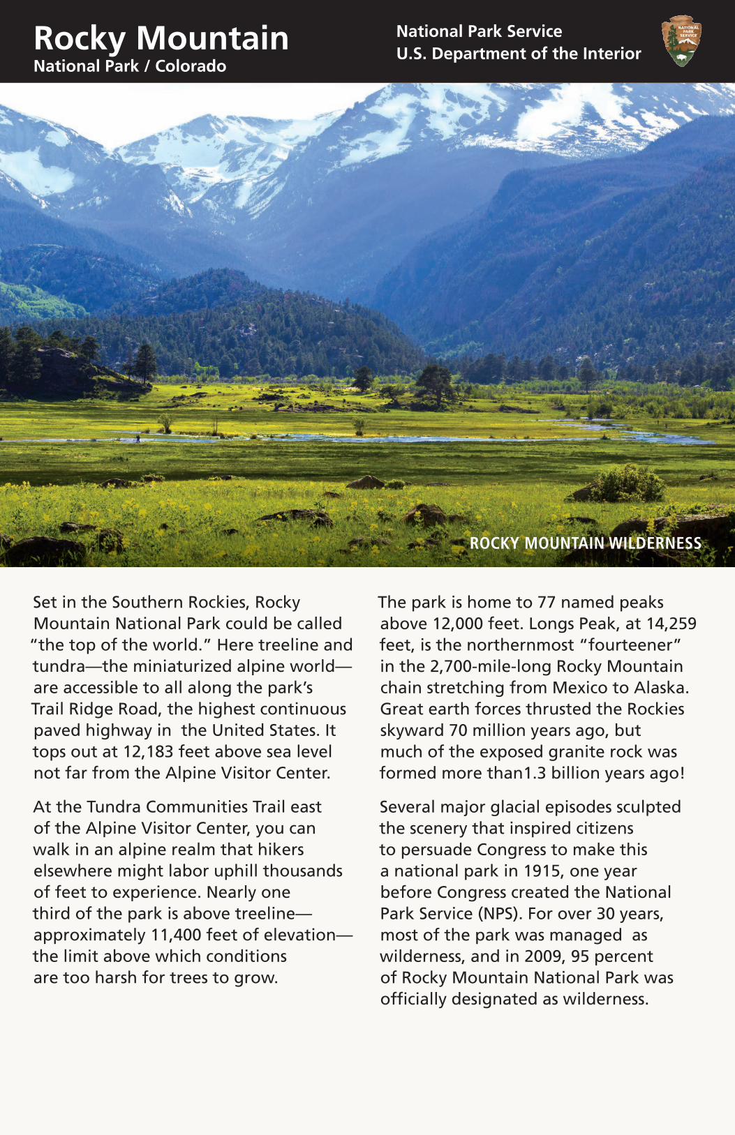
Rocky Mountain National Park / Colorado National Park Service U.S. Department of the Interior Set in the Southern Rockies, Rocky Mountain National Park could be called “the top of the world.” Here treeline and tundra—the miniaturized alpine world— are accessible to all along the park’s Trail Ridge Road, the highest continuous paved highway in the United States. It tops out at 12,183 feet above sea level not far from the Alpine Visitor Center. At the Tundra Communities Trail east of the Alpine Visitor Center, you can walk in an alpine realm that hikers elsewhere might labor uphill thousands of feet to experience. Nearly one third of the park is above treeline— approximately 11,400 feet of elevation— the limit above which conditions are too harsh for trees to grow. The park is home to 77 named peaks above 12,000 feet. Longs Peak, at 14,259 feet, is the northernmost “fourteener” in the 2,700-mile-long Rocky Mountain chain stretching from Mexico to Alaska. Great earth forces thrusted the Rockies skyward 70 million years ago, but much of the exposed granite rock was formed more than1.3 billion years ago! Several major glacial episodes sculpted the scenery that inspired citizens to persuade Congress to make this a national park in 1915, one year before Congress created the National Park Service (NPS). For over 30 years, most of the park was managed as wilderness, and in 2009, 95 percent of Rocky Mountain National Park was officially designated as wilderness. ROCKY MOUNTAIN WILDERNESS
Transcript of Rocky Mountain National Park Service · 2017-10-30 · Rocky Mountain National Park / Colorado...
Rocky MountainNational Park / Colorado
National Park ServiceU.S. Department of the Interior
Set in the Southern Rockies, Rocky Mountain National Park could be called “the top of the world.” Here treeline and tundra—the miniaturized alpine world—are accessible to all along the park’s Trail Ridge Road, the highest continuous paved highway in the United States. It tops out at 12,183 feet above sea level not far from the Alpine Visitor Center.
At the Tundra Communities Trail east of the Alpine Visitor Center, you can walk in an alpine realm that hikers elsewhere might labor uphill thousands of feet to experience. Nearly one third of the park is above treeline—approximately 11,400 feet of elevation—the limit above which conditions are too harsh for trees to grow.
The park is home to 77 named peaks above 12,000 feet. Longs Peak, at 14,259 feet, is the northernmost “fourteener” in the 2,700-mile-long Rocky Mountain chain stretching from Mexico to Alaska. Great earth forces thrusted the Rockies skyward 70 million years ago, but much of the exposed granite rock was formed more than1.3 billion years ago!
Several major glacial episodes sculpted the scenery that inspired citizens to persuade Congress to make this a national park in 1915, one year before Congress created the National Park Service (NPS). For over 30 years, most of the park was managed as wilderness, and in 2009, 95 percent of Rocky Mountain National Park was officially designated as wilderness.
ROCKY MOUNTAIN WILDERNESS

Ecosystems of the Rockies
BIGHORN SHEEP RAM

Alpine: Above 11,400 feetAlpine tundra occurs above treeline where the climate is extremely harsh. Fierce drying winds, bitter cold, intense ultraviolet light, thin soil, and a brief growing season let only specialized plants and animals thrive.
Alpine plants are tiny, growing close to the ground. Many have waxy leaf surfaces to resist moisture loss, or dense, tiny hairs to trap warmth against stems and leaves. Plants just inches tall may grow taproots 6 feet long to get moisture and anchor them against the wind. Alpine winters are long—for nearly eight months, average temperatures do not rise above freezing.
Mammals and birds survive by migrating, hibernating, or staying put.
The White-tailed ptarmigan, a ground dwelling, grouse-like bird, is well-adapted for staying put. Its large, dense, feather-covered body retains heat well. Ptarmigan can even gain weight in winter by eating nutrient rich willow buds.
Yellow-bellied marmots, one of the largest members of the squirrel family, escape winter by piling on fat in summer, nearly doubling their size, then hibernating seven to eight months. They survive by greatly slowing their metabolism and heartbeat, and by lowering their body temperature to 40ºF.
Most other birds and mammals migrate when shorter, cooler days arrive. American pipits fly to Central America, while other tundra dwellers like elk and coyotes move down into lower valleys.
Subalpine: 9,000–11,400 feetThe subalpine ecosystem lies between 9,000 and 11,400 feet and is characterized by long, cold winters, short, cool summers, and high annual precipitation—30 inches or more. It is the highest, windiest, and snowiest forest.
Engelmann spruce and Subalpine fir dominate the landscape. But abundant moisture produces a rich understory of Broom huckleberry and Juniper shrubs, as well as many colorful wildflowers like Arnica, Fairy slipper, Twinflower, and Senecio.
Limber pines thrive in wind blown areas and often have a twisted growth habit. Winds can also stop growth on the windward side of spruce and fir trees, creating flag or banner trees. At treeline, low-growing trees called krummholz (German for “crooked wood”) grow more horizontally than vertically, and some may be hundreds of years old.
Pine martens, Long-tailed weasels, Chickarees (pine squirrels), and Snowshoe hares frequent the subalpine forests. Birds like the Hermit thrush, Ruby-crowned kinglet and Pine grosbeak are more often heard than seen in the dense cover.
Montane: below 9,000 feetAs you enter the park, you are entering the montane ecosystem—a land of pine forests and beautiful mountain meadows. Open stands of Ponderosa pine dominate the drier south-facing slopes of the montane. Mature trees can be 150 feet tall and 400 years old. As the ponderosa ages, its bark changes from gray-brown to cinnamon-red and often gives off a sweet fragrance when warmed by the sun.
Many grasses, shrubs, and flowering plants thrive in the montane. Chokecherry and wax currant bushes provide food and shelter for many insects, birds, and other animals, including Mountain bluebirds, bears, tassel-eared Abert’s squirrels, coyotes, Red-tailed hawks, and deer and elk.

03
Mile
s2
03
Kilo
met
ers
2
Park
En
tran
cePo
int
of
Inte
rest
His
tori
cal S
ite
Way
sid
ePa
ved
Ro
adU
np
aved
Ro
ad
Park
bo
un
dar
yC
on
tin
enta
l Div
ide
Wh
eelc
hai
r-A
cces
sib
le
Self
-Gu
ided
N
atu
re T
rail
Riv
er /
Lake
Cam
pg
rou
nd
Picn
ic a
rea
Res
tro
om
s
Ran
ger
Sta
tio
n
Emer
gen
cy
Tele
ph
on
e
N
Mo
rain
e Pa
rkD
isco
very
Cen
ter
Lak
e R
oad
34
34
Bea
ver
Mea
do
ws
Vis
ito
r C
ente
r
Alp
ine
Vis
ito
r C
ente
r
Site
of
Lulu
Cit
y
Ho
lzw
arth
His
tori
c Si
te
Lon
gs
Peak
(ten
ts o
nly
)
Coyo
te V
alle
y Tr
ailh
ead
Gra
nd
Lak
eEn
tran
ce S
tati
on
Tim
ber
Cre
ek
Fall
Riv
erEn
tran
ce
Stat
ion
Shee
p
Lake
s
Bea
ver
Mea
do
ws
Entr
ance
St
atio
n
Lily
Lak
e
Fall
Riv
er
Vis
ito
r C
ente
r
36
66
36
34
34
Kaw
un
eech
eV
isit
or
Cen
ter
Lon
gs
Peak
14,2
59 f
t4,
346
m
Gla
cier
Bas
in
Spra
gu
e La
ke
Trai
lhea
d
Bea
r La
ke
Trai
lhea
d
Mo
rain
e Pa
rk
Asp
eng
len
ESTE
SPA
RK
Mee
ker
Park
All
ensp
ark
Wil
d B
asin
Trai
lhea
d
(no
wat
er)
Wil
d B
asin
Entr
ance
Sta
tio
n
7
34
7
Ma
p L
eg
en
dR
ock
y M
ou
nta
in N
atio
nal
Par
k
Ho
lzw
arth
His
tori
c Si
te
All
vis
ito
r ce
nte
rs a
re a
cces
sib
le i
ncl
ud
ing
res
tro
om
s.La
ke G
ran
by
Gra
nd
Lak
e
Shad
ow
M
ou
nta
in
Lake
Co ntine
ntal D
ivide
Lily
Lak
e
Gla
cier
Bas
in
Devils Gulch
Road
Shee
p
Lake
s
O ld F
all R
iver
Ro
adTr
ail
Ridg
e R oad
Bea
ver
Mea
do
ws
Entr
ance
St
atio
n

03
Mile
s2
03
Kilo
met
ers
2
Park
En
tran
cePo
int
of
Inte
rest
His
tori
cal S
ite
Way
sid
ePa
ved
Ro
adU
np
aved
Ro
ad
Park
bo
un
dar
yC
on
tin
enta
l Div
ide
Wh
eelc
hai
r-A
cces
sib
le
Self
-Gu
ided
N
atu
re T
rail
Riv
er /
Lake
Cam
pg
rou
nd
Picn
ic a
rea
Res
tro
om
s
Ran
ger
Sta
tio
n
Emer
gen
cy
Tele
ph
on
e
N
Mo
rain
e Pa
rkD
isco
very
Cen
ter
Lak
e R
oad
34
34
Bea
ver
Mea
do
ws
Vis
ito
r C
ente
r
Alp
ine
Vis
ito
r C
ente
r
Site
of
Lulu
Cit
y
Ho
lzw
arth
His
tori
c Si
te
Lon
gs
Peak
(ten
ts o
nly
)
Coyo
te V
alle
y Tr
ailh
ead
Gra
nd
Lak
eEn
tran
ce S
tati
on
Tim
ber
Cre
ek
Fall
Riv
erEn
tran
ce
Stat
ion
Shee
p
Lake
s
Bea
ver
Mea
do
ws
Entr
ance
St
atio
n
Lily
Lak
e
Fall
Riv
er
Vis
ito
r C
ente
r
36
66
36
34
34
Kaw
un
eech
eV
isit
or
Cen
ter
Lon
gs
Peak
14,2
59 f
t4,
346
m
Gla
cier
Bas
in
Spra
gu
e La
ke
Trai
lhea
d
Bea
r La
ke
Trai
lhea
d
Mo
rain
e Pa
rk
Asp
eng
len
ESTE
SPA
RK
Mee
ker
Park
All
ensp
ark
Wil
d B
asin
Trai
lhea
d
(no
wat
er)
Wil
d B
asin
Entr
ance
Sta
tio
n
7
34
7
Ma
p L
eg
en
dR
ock
y M
ou
nta
in N
atio
nal
Par
k
Ho
lzw
arth
His
tori
c Si
te
All
vis
ito
r ce
nte
rs a
re a
cces
sib
le i
ncl
ud
ing
res
tro
om
s.La
ke G
ran
by
Gra
nd
Lak
e
Shad
ow
M
ou
nta
in
Lake
Co ntine
ntal D
ivide
Lily
Lak
e
Gla
cier
Bas
in
Devils Gulch
Road
Shee
p
Lake
s
O ld F
all R
iver
Ro
adTr
ail
Ridg
e R oad
Bea
ver
Mea
do
ws
Entr
ance
St
atio
n

Mountain People NEVER SUMMER MOUNTAIN FROM KAWUNEECHE VALLEY
Mountain Ute and ArapahoFollowing retreating glaciers 10,000 years ago, humans first began living intermittently in these mountains. By 6,000 years ago the Ute, or Mountain People, lived in bands scattered throughout Colorado and Utah. They followed game and traveled over set seasonal routes collecting plants. Other groups, including the Cheyenne and Arapaho, lived primarily on the plains, hunting buffalo, with occasional mountain excursions.
European Americans ArriveEarly 1800s European American fur trappers and traders sought beaver throughout the Rockies until pelt prices fell in the 1840s. The 1859 Colorado gold rush created the boom towns of
Denver, Boulder, and Golden. Mining didn’t pay much here, but people discovered the areas beauty. Gold-seeker Joel Estes found the valley now named for him. In 1860, he built cabins for ranching, but scenery soon outpaced commodities in value and tourism grew.
ProtectorsTourism continued growing in Estes Park and Grand Lake as word of the surrounding mountains beauty spread. A forest preserve was created, but many conservationists feared the surrounding mountains would be exploited. Through the efforts of Enos Mills, F.O. Stanley, James Grafton Rogers, Joe Mills, and other Colorado citizens, Congress established Rocky Mountain National Park in 1915.
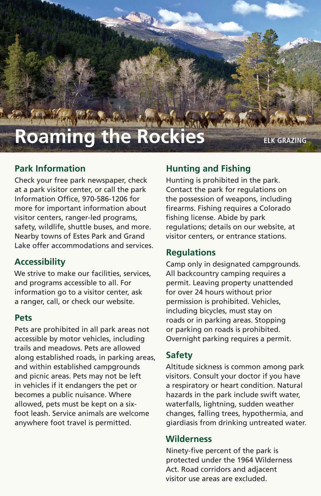
Roaming the Rockies ELK GRAZING
Park InformationCheck your free park newspaper, check at a park visitor center, or call the park Information Office, 970-586-1206 for more for important information about visitor centers, ranger-led programs, safety, wildlife, shuttle buses, and more. Nearby towns of Estes Park and Grand Lake offer accommodations and services.
AccessibilityWe strive to make our facilities, services, and programs accessible to all. For information go to a visitor center, ask a ranger, call, or check our website.
PetsPets are prohibited in all park areas not accessible by motor vehicles, including trails and meadows. Pets are allowed along established roads, in parking areas, and within established campgrounds and picnic areas. Pets may not be left in vehicles if it endangers the pet or becomes a public nuisance. Where allowed, pets must be kept on a six-foot leash. Service animals are welcome anywhere foot travel is permitted.
Hunting and FishingHunting is prohibited in the park. Contact the park for regulations on the possession of weapons, including firearms. Fishing requires a Colorado fishing license. Abide by park regulations; details on our website, at visitor centers, or entrance stations.
RegulationsCamp only in designated campgrounds. All backcountry camping requires a permit. Leaving property unattended for over 24 hours without prior permission is prohibited. Vehicles, including bicycles, must stay on roads or in parking areas. Stopping or parking on roads is prohibited. Overnight parking requires a permit.
SafetyAltitude sickness is common among park visitors. Consult your doctor if you have a respiratory or heart condition. Natural hazards in the park include swift water, waterfalls, lightning, sudden weather changes, falling trees, hypothermia, and giardiasis from drinking untreated water.
WildernessNinety-five percent of the park is protected under the 1964 Wilderness Act. Road corridors and adjacent visitor use areas are excluded.

For More Information Rocky Mountain National Park
1000 U.S. Highway 36 Estes Park, CO 80517-8397 970-586-1206 970-586-1319 TTY www.nps.gov/romo
For information call 970-586-1206
For Trail Ridge Road status call 970-586-1222.
Rocky Mountain National Park is one of over 400 parks in the National Park System. To learn more about national parks and programs in America’s communities, visit www.nps.gov
TRAIL RIDGE ROAD