Road Safety Audit - Massachusetts Department of … · Road Safety Audit—Route 18 (Bedford St) at...
41
ROAD SAFETY AUDIT Route 18 (Bedford Street) at Auburn Street (Route 14) and Temple Street (Route 27) Town of Whitman March 3, 2015 Prepared For: MassDOT Highway Division Prepared By: BETA Group, Inc.
Transcript of Road Safety Audit - Massachusetts Department of … · Road Safety Audit—Route 18 (Bedford St) at...
ROAD SAFETY AUDIT
Route 18 (Bedford Street) at Auburn Street (Route 14) and Temple Street (Route 27)
Town of Whitman
March 3, 2015
Prepared For:
MassDOT Highway Division
Prepared By:
BETA Group, Inc.
Road Safety Audit—Route 18 (Bedford St) at Route 14 and Route 27—Whitman, MA Prepared by BETA Group, Inc.
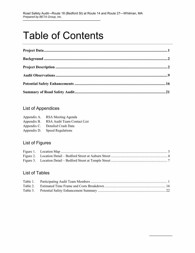
Table of Contents Project Data ................................................................................................................................. 1
Background ................................................................................................................................. 2
Project Description ..................................................................................................................... 2
Audit Observations ..................................................................................................................... 9
Potential Safety Enhancements ............................................................................................... 16
Summary of Road Safety Audit ............................................................................................... 21
List of Appendices
Appendix A. RSA Meeting Agenda
Appendix B. RSA Audit Team Contact List Appendix C. Detailed Crash Data
Appendix D. Speed Regulations
List of Figures
Figure 1. Location Map ......................................................................................................................... 3
Figure 2. Location Detail – Bedford Street at Auburn Street ................................................................ 4
Figure 3. Location Detail – Bedford Street at Temple Street ................................................................ 7
List of Tables
Table 1. Participating Audit Team Members ....................................................................................... 1
Table 2. Estimated Time Frame and Costs Breakdown ..................................................................... 16
Table 3. Potential Safety Enhancement Summary ............................................................................. 22
Road Safety Audit—Route 18 (Bedford St) at Route 14 and Route 27—Whitman, MA Prepared by BETA Group, Inc.
Page 1
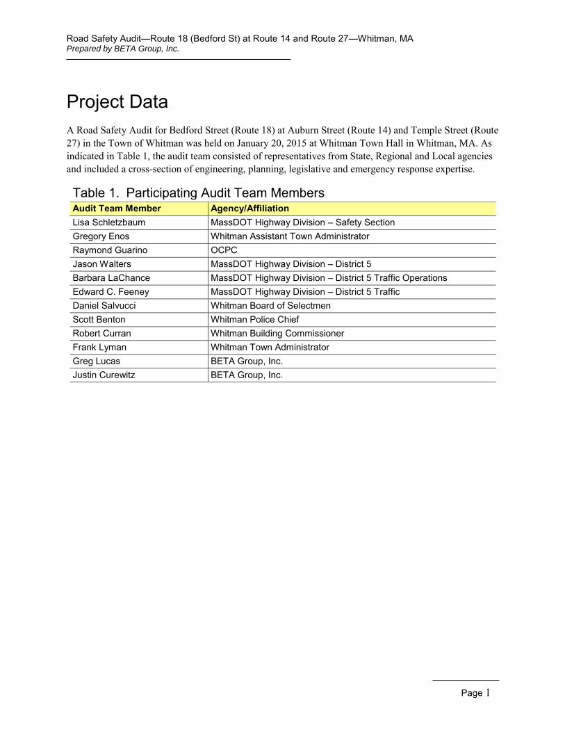
Project Data A Road Safety Audit for Bedford Street (Route 18) at Auburn Street (Route 14) and Temple Street (Route 27) in the Town of Whitman was held on January 20, 2015 at Whitman Town Hall in Whitman, MA. As indicated in Table 1, the audit team consisted of representatives from State, Regional and Local agencies and included a cross-section of engineering, planning, legislative and emergency response expertise.
Table 1. Participating Audit Team Members Audit Team Member Agency/Affiliation Lisa Schletzbaum MassDOT Highway Division – Safety Section Gregory Enos Whitman Assistant Town Administrator Raymond Guarino OCPC Jason Walters MassDOT Highway Division – District 5 Barbara LaChance MassDOT Highway Division – District 5 Traffic Operations Edward C. Feeney MassDOT Highway Division – District 5 Traffic Daniel Salvucci Whitman Board of Selectmen Scott Benton Whitman Police Chief Robert Curran Whitman Building Commissioner Frank Lyman Whitman Town Administrator Greg Lucas BETA Group, Inc. Justin Curewitz BETA Group, Inc.
Road Safety Audit—Route 18 (Bedford St) at Route 14 and Route 27—Whitman, MA Prepared by BETA Group, Inc.
Page 2
Background The Federal Highway Administration defines a Road Safety Audit (RSA) as the formal safety examination of an existing or future road or intersection by an independent, multidisciplinary team. The purpose of an RSA is to identify potential safety issues and possible opportunities for safety improvements considering all roadway users. A Road Safety Audit was scheduled for the intersections of Bedford Street (Route 18) with Auburn Street (Route 14) and Temple Street (Route 27) because both intersections have been identified as high crash locations within the Old Colony Planning Council (OCPC) region. The intersection of Bedford Street and Temple Street also ranks 145th on MassDOT’s list of the Top 200 High Crash Locations Statewide from 2010-2012. A project has been initiated to make traffic and safety improvements to both intersections (MassDOT File No. 607860). The RSA is intended to identify potential short and long term safety improvements that can be made at each intersection, which can then be implemented through general maintenance for short term low cost improvements or incorporated into the future project to the greatest extent practicable.
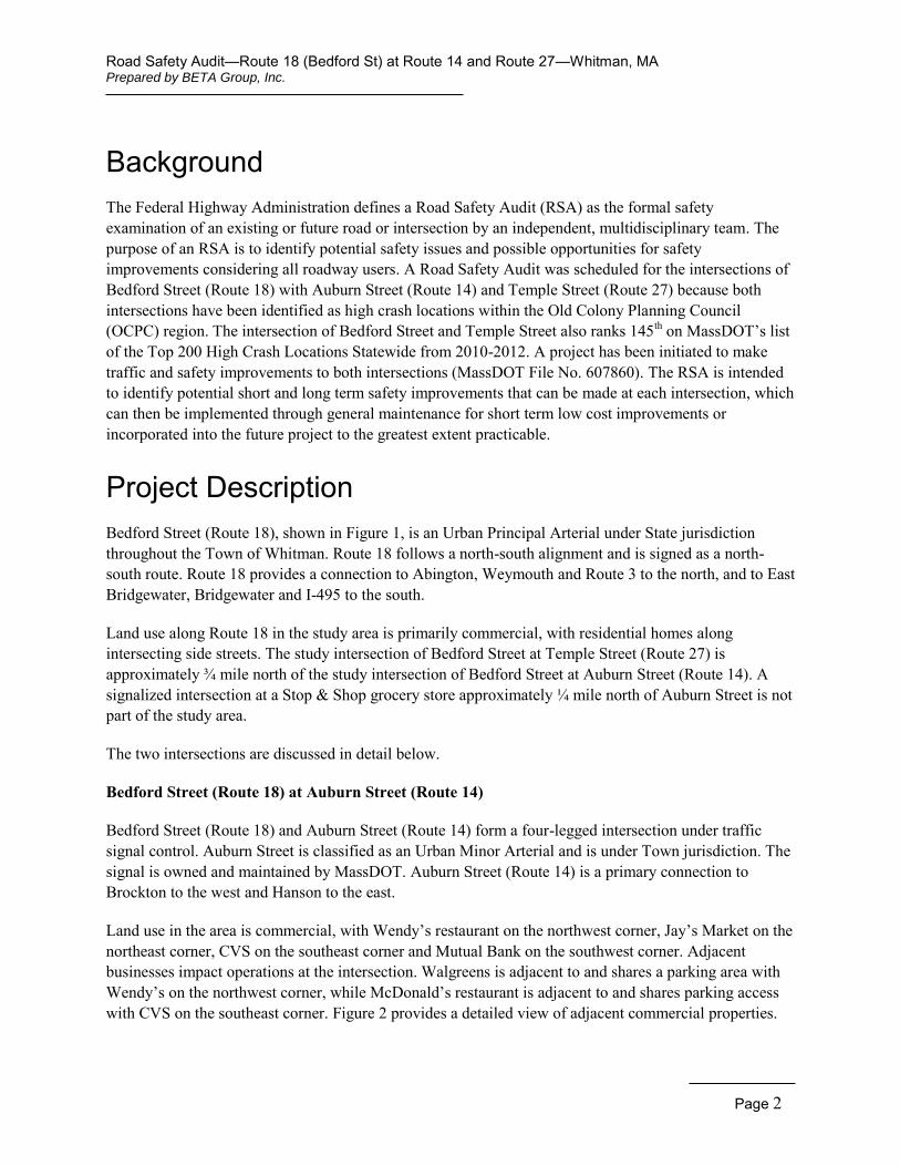
Project Description Bedford Street (Route 18), shown in Figure 1, is an Urban Principal Arterial under State jurisdiction throughout the Town of Whitman. Route 18 follows a north-south alignment and is signed as a north-south route. Route 18 provides a connection to Abington, Weymouth and Route 3 to the north, and to East Bridgewater, Bridgewater and I-495 to the south.
Land use along Route 18 in the study area is primarily commercial, with residential homes along intersecting side streets. The study intersection of Bedford Street at Temple Street (Route 27) is approximately ¾ mile north of the study intersection of Bedford Street at Auburn Street (Route 14). A signalized intersection at a Stop & Shop grocery store approximately ¼ mile north of Auburn Street is not part of the study area.
The two intersections are discussed in detail below.
Bedford Street (Route 18) at Auburn Street (Route 14)
Bedford Street (Route 18) and Auburn Street (Route 14) form a four-legged intersection under traffic signal control. Auburn Street is classified as an Urban Minor Arterial and is under Town jurisdiction. The signal is owned and maintained by MassDOT. Auburn Street (Route 14) is a primary connection to Brockton to the west and Hanson to the east.
Land use in the area is commercial, with Wendy’s restaurant on the northwest corner, Jay’s Market on the northeast corner, CVS on the southeast corner and Mutual Bank on the southwest corner. Adjacent businesses impact operations at the intersection. Walgreens is adjacent to and shares a parking area with Wendy’s on the northwest corner, while McDonald’s restaurant is adjacent to and shares parking access with CVS on the southeast corner. Figure 2 provides a detailed view of adjacent commercial properties.
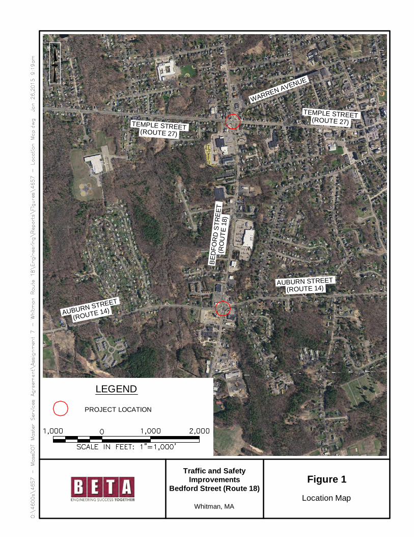
Figure 1
Location Map
LEGEND
PROJECT LOCATION
TEMPLE STREET(ROUTE 27)
Traffic and SafetyImprovements
Bedford Street (Route 18)
Whitman, MA
TEMPLE STREET(ROUTE 27)
AUBURN STREET(ROUTE 14)
BED
FOR
DS
TREE
T(R
OU
TE18
)
AUBURN STREET
(ROUTE 14)
WARREN AVENUE
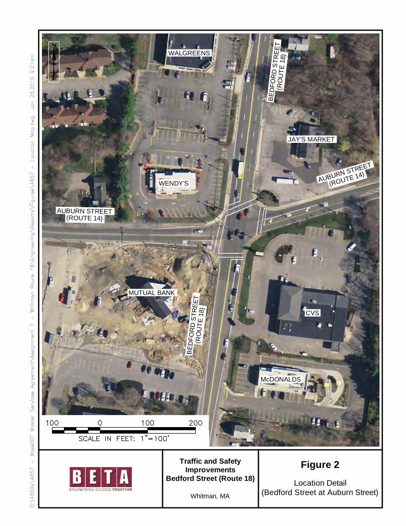
Figure 2
Location Detail(Bedford Street at Auburn Street)
Traffic and SafetyImprovements
Bedford Street (Route 18)
Whitman, MA
AUBURN STREET
(ROUTE 14)
BED
FOR
DS
TREE
T(R
OU
TE18
)AUBURN STREET
(ROUTE 14)
BED
FOR
DS
TREE
T(R
OU
TE18
)
CVS
McDONALDS
MUTUAL BANK
WENDY'S
WALGREENS
JAY'S MARKET
Road Safety Audit—Route 18 (Bedford St) at Route 14 and Route 27—Whitman, MA Prepared by BETA Group, Inc.
Page 5
Bedford Street at Auburn Street (looking south)
Bedford Street provides two lanes in each direction at Auburn Street, with turns accommodated within shared lanes. A solid white edge line is provided to delineate a shoulder, but widths are not sufficient to safely accommodate bicycles. The northbound and southbound approaches widen to two lanes at the intersection and merge back to a single lane departing the intersection. The northbound approach widens to two defined lanes just north of the shared CVS/McDonald’s driveway, approximately 110 feet in advance of the northbound stop line. The roadway provides two lanes northbound departing the intersection for approximately 380 feet before merging back to a single lane. It was noted that drivers show aggressive tendencies when traveling through the intersection because they are aware of the impending merge and want to “beat” the driver in the adjacent lane. The southbound approach provides two defined lanes for approximately 225 feet in advance of the stop line. The roadway provides two defined lanes in the vicinity of the shared Wendy’s/Walgreens driveway, which is approximately 100 feet in advance of the stop line. The roadway provides enough width for two lanes for approximately 100 feet departing the intersection southbound, but is not marked as such.
Auburn Street (Route 14) generally provides a single lane in each direction, but widens to provide a shared lane for left turns and through vehicles as well as a right turn lane eastbound at Bedford Street. The westbound Auburn Street approach widens to provide an exclusive left turn lane, and a shared lane for through vehicles and right turns. Arrow and ONLY markings are provided for the eastbound right turn lane and the westbound left turn lane. A solid white edge line is provided to delineate a shoulder, but widths are not sufficient to safely accommodate bicycles.
The traffic signal provides a phase for the Bedford Street approaches, a protected advance phase for the Auburn Street eastbound approach, and a concurrent phase for the Auburn Street approaches. The eastbound left turn is the only left turn which is afforded a protected phase. An exclusive pedestrian phase is activated by pedestrian pushbutton on all four corners of the intersection. No Turn on Red restrictions are signed for all four approaches.
Continuous sidewalks are provided along the east side of Bedford Street and along the north side of Auburn Street. Sidewalk on the southwest corner extends to a sidewalk leading to Mutual Bank, while sidewalk on the southeast corner does not extend along the CVS property on Auburn Street.
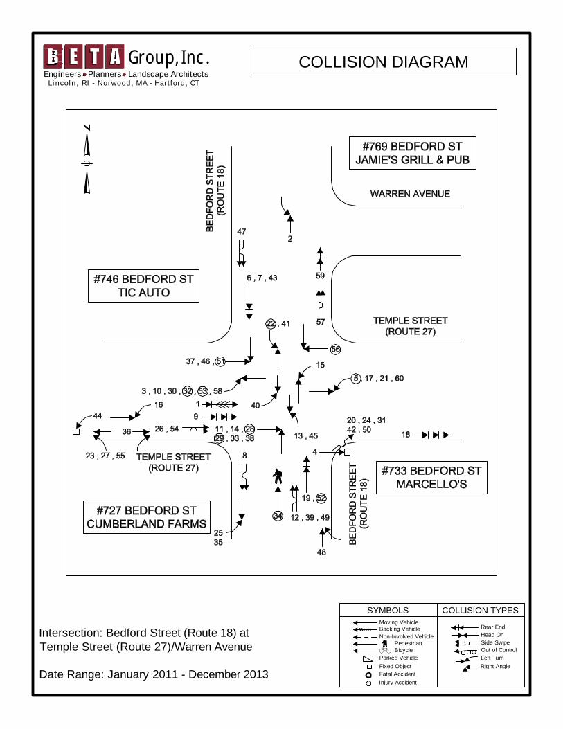
Crash data provided by the Whitman Police Department show 46 crashes occurred at the intersection for the three year period from 2011 through 2013. A crash data summary and a collision diagram are included in the Appendix. The most prevalent crash type were angle crashes, comprising 46% of all crashes. Angle
Road Safety Audit—Route 18 (Bedford St) at Route 14 and Route 27—Whitman, MA Prepared by BETA Group, Inc.
Page 6
crashes occurred from all approaches; including four between a northbound left turning vehicle and a southbound through vehicle, and three between a southbound left turning vehicle and a northbound through vehicle. Angle crashes were common entering and exiting the commercial driveways adjacent to the intersection, including four vehicles turning left to exit the shared Wendy’s/Walgreens driveway being struck by a southbound through vehicle, and one northbound entering vehicle also being struck by a southbound through vehicle. The crashes involving exiting vehicles were all identified as “courtesy crashes.” A courtesy crash occurs when a vehicle stops, contrary to the rules of the road, to let another vehicle enter the traffic stream or turn across stopped traffic to a driveway or side street. On a two-lane approach like Bedford Street southbound, the vehicle in the lane closest to the curb stops to let the exiting vehicle go, but the exiting vehicle then collides with an unseen vehicle in the inside lane.
Two of three crashes involving vehicles exiting Jay’s Market (former 7-11) were also identified as courtesy crashes on the two-lane Auburn Street westbound approach. One angle and two rear-end crashes involved vehicles entering and exiting Wendy’s on Auburn Street, while three angle crashes involved vehicles entering or exiting the shared CVS/McDonald’s driveway on Bedford Street.
Sixteen rear-end crashes occurred at the intersection, including four southbound, three northbound, three westbound and one eastbound. Rear-end crashes also occurred involving both southbound left-turning vehicles, and northbound right-turning vehicles. Also of note are sideswipe crashes indicating lane shifts or confusion over lane assignments. Two sideswipe crashes occurred northbound and one southbound.
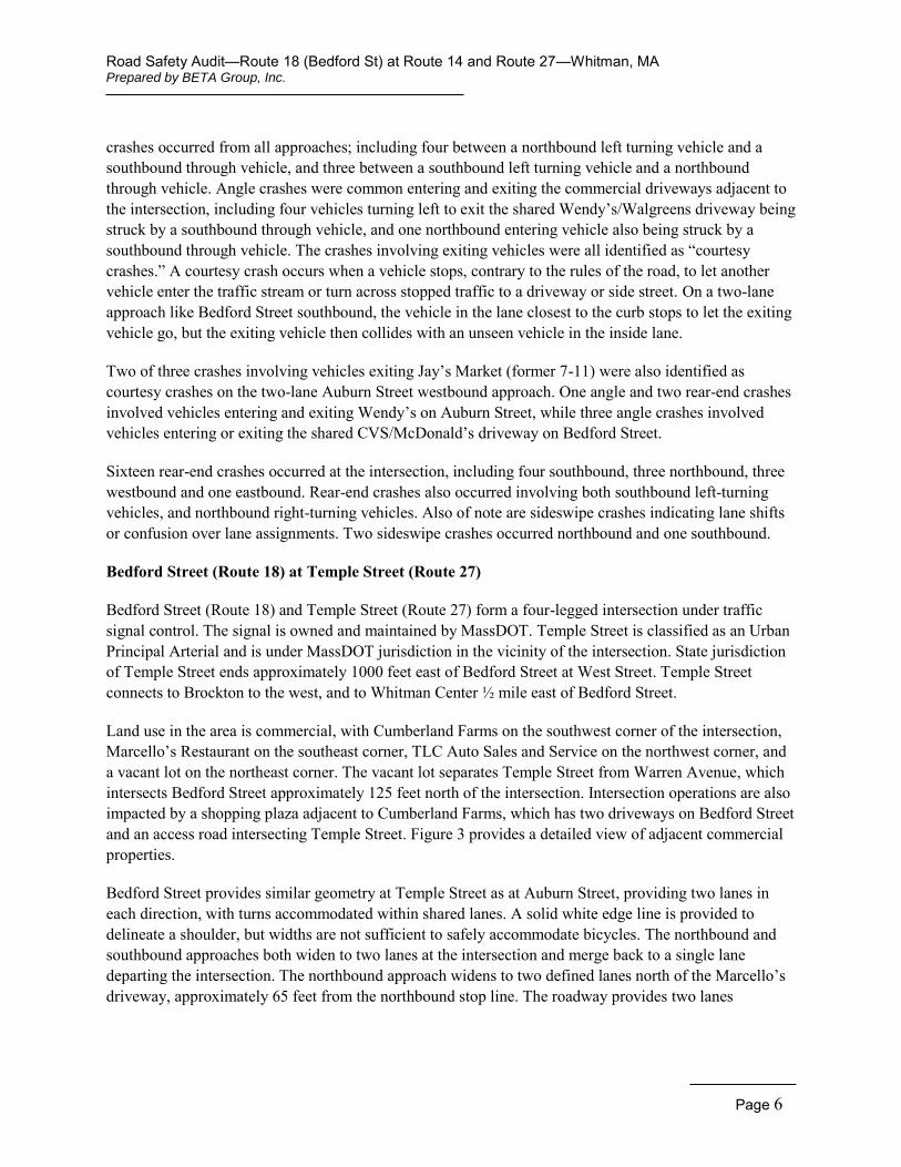
Bedford Street (Route 18) at Temple Street (Route 27)
Bedford Street (Route 18) and Temple Street (Route 27) form a four-legged intersection under traffic signal control. The signal is owned and maintained by MassDOT. Temple Street is classified as an Urban Principal Arterial and is under MassDOT jurisdiction in the vicinity of the intersection. State jurisdiction of Temple Street ends approximately 1000 feet east of Bedford Street at West Street. Temple Street connects to Brockton to the west, and to Whitman Center ½ mile east of Bedford Street.
Land use in the area is commercial, with Cumberland Farms on the southwest corner of the intersection, Marcello’s Restaurant on the southeast corner, TLC Auto Sales and Service on the northwest corner, and a vacant lot on the northeast corner. The vacant lot separates Temple Street from Warren Avenue, which intersects Bedford Street approximately 125 feet north of the intersection. Intersection operations are also impacted by a shopping plaza adjacent to Cumberland Farms, which has two driveways on Bedford Street and an access road intersecting Temple Street. Figure 3 provides a detailed view of adjacent commercial properties.
Bedford Street provides similar geometry at Temple Street as at Auburn Street, providing two lanes in each direction, with turns accommodated within shared lanes. A solid white edge line is provided to delineate a shoulder, but widths are not sufficient to safely accommodate bicycles. The northbound and southbound approaches both widen to two lanes at the intersection and merge back to a single lane departing the intersection. The northbound approach widens to two defined lanes north of the Marcello’s driveway, approximately 65 feet from the northbound stop line. The roadway provides two lanes
Figure 3
Location Detail(Bedford Street at Temple Street)
TEMPLE STREET(ROUTE 27)
Traffic and SafetyImprovements
Bedford Street (Route 18)
Whitman, MA
TEMPLE STREET(ROUTE 27)B
EDFO
RD
STR
EET
(RO
UTE
18)
WARREN AVENUE
BED
FOR
DS
TREET
(RO
UTE
18)
MARCELLO'S
CUMBERLAND FARMS
TLC AUTO
DUNKINDONUTS
Road Safety Audit—Route 18 (Bedford St) at Route 14 and Route 27—Whitman, MA Prepared by BETA Group, Inc.
Page 8
Bedford Street at Temple Street (looking north)
northbound departing the intersection for approximately 110 feet before merging back to a single lane in the vicinity of Warren Avenue, which intersects Bedford Street from the east. The southbound approach provides two defined lanes for approximately 320 feet in advance of the stop line. The roadway provides enough width for two cars to travel side by side immediately departing the intersection, but is not marked as such.
Temple Street (Route 27) generally provides a single lane in each direction, but widens to provide two shared lanes in each direction at Bedford Street. The two lane section extends approximately 100 feet eastbound and approximately 60 feet westbound departing the intersection before merging back into a single lane. A solid white edge line is provided to delineate a shoulder, but widths are not sufficient to safely accommodate bicycles.
The traffic signal provides a phase for the Bedford Street approaches, a protected advance phase for the Temple Street westbound approach, and a concurrent phase for the Temple Street approaches. An exclusive pedestrian phase is activated by pedestrian pushbutton on all four corners of the intersection. No Turn on Red restrictions are signed for all four approaches.
Continuous sidewalks are provided along both sides of both intersecting streets in the vicinity of the intersection. The sidewalk on the west side of Bedford Street south of the intersection does not extend beyond the Cumberland Farms property.
Crash data provided by the Whitman Police Department show 60 crashes occurred at the intersection for the three year period from 2011 through 2013. A crash data summary and a collision diagram are included in the Appendix. The most prevalent crash type were angle crashes, comprising 58% of all crashes. Of particular note are crashes involving left turning vehicles from Temple Street; six occurred between an eastbound left turning vehicle and a westbound through vehicle, while four occurred between a westbound left turning vehicle and an eastbound through vehicle. Six crashes occurred between an eastbound through vehicle and a northbound vehicle, while three involved an eastbound through vehicle and a southbound vehicle. Angle crashes were common entering and exiting the commercial driveways adjacent to the intersection. Three crashes involved vehicles exiting Cumberland Farms, two turning left onto Bedford Street and one turning right onto Temple Street. Three crashes involved left turns from the shopping plaza adjacent to Cumberland Farms onto Temple Street. One crash involved a vehicle turning right from Marcello’s onto Bedford Street northbound.
Five crashes were identified as fixed-object crashes involving a northbound right turning vehicle. All five involved a right turning tractor-trailer striking the traffic signal post on the southeast corner. Rear-end crashes occurred on the northbound, southbound, and eastbound approaches. Three sideswipe crashes occurred on the northbound approach, two on the eastbound approach, one on the southbound approach, and one northbound departing the intersection.
Road Safety Audit—Route 18 (Bedford St) at Route 14 and Route 27—Whitman, MA Prepared by BETA Group, Inc.
Page 9
Audit Observations Following a brief introduction to the RSA process and a summary of existing geometry and crash information, the audit participants were asked to discuss safety issues at the intersections of Bedford Street (Route 18) with Auburn Street (Route 14) and Temple Street (Route 27). Audit participants then conducted a site visit as a group, at which time they offered observations on safety issues and concerns. A summary of those major safety considerations is as follows:
Bedford Street (Route 18) at Auburn Street (Route 14)
Traffic Congestion – A number of items related to traffic congestion were noted as safety issues.
o The level of traffic traveling through the intersection is high, and Route 14 serves as a primary connector to Brockton from Whitman and East Bridgewater.
o The lack of left turn lanes and/or protected movements for left turns was noted as both a safety and operational issue at the intersection. Crashes involving left turning vehicles on all approaches can be related to this issue, as the delay a driver experiences waiting for an acceptable gap under permissive operation can create frustration, increase aggression and increase the potential for red light violations and acceptance of inadequate gaps.
o The existing No Turn on Red restrictions were noted as a safety concern because of the increased delay from vehicles that must wait to turn right instead of turning right on red. One audit participant recalled that MassDOT agreed approximately seven years ago to remove the No Turn on Red sign for the right turn lane on Auburn Street eastbound, but that the sign was never removed. Increased delay can increase frustration and aggression, as previously noted.
Access Management – The proximity of businesses and commercial driveways causes access management to be of particular concern as it relates to safety.
o The history of courtesy crashes at the shared Wendy’s/Walgreens driveway on Route 18 is likely related to the four lane cross-section of Bedford Street at this location. Drivers traveling north are also considering the lane merge ahead, and potentially are less likely to pay attention to vehicles entering from the left. Four crashes at this driveway involved vehicles turning left to travel north on Bedford Street; all four were identified as courtesy crashes.
o It was noted that Jay’s Market has plans to add gas pumps. This location previously housed a 7-Eleven which had a gas island with two pumps, which were later removed. It was suggested that the addition of gas pumps and competitive gas pricing would increase traffic entering and exiting at this location. No crashes involved vehicles entering or exiting Jay’s Market on Bedford Street, but three crashes involved vehicles exiting on Auburn Street, where exiting left-turning vehicles must cross a two lane approach.
o Vehicles queued on Auburn Street westbound that wish to enter the CVS driveway will cross into oncoming traffic to bypass the queue and access the driveway. One crash occurred involving a vehicle entering this driveway.
Road Safety Audit—Route 18 (Bedford St) at Route 14 and Route 27—Whitman, MA Prepared by BETA Group, Inc.
Page 10
Sidewalk end on southwest corner
Lane Designation and Alignment – The beginning and end points of the two lane segments on both Bedford Street and Auburn Street are not well signed and have faded pavement markings. Lane designation signage and merge signage are not consistently provided, and the length of the merge is inadequate. Traffic congestion also contributes to this issue by increasing driver aggression, causing more aggressive drivers to jump into the second lane as soon as it is available, and “racing” to the merge point when the two-lane segment ends. Sideswipe crashes on Bedford Street in both directions are potentially related to confusion over lane assignments.
Truck Route – It was noted that Route 14 has been designated as a truck route. Signage at the Route 27/Route 58 intersection in Hanson encourages trucks to use Route 14 rather than Route 27 to access Brockton. Truck traffic can exacerbate other safety concerns relating to delay and queuing.
Truck Turns – A southbound tractor trailer turning left onto Auburn Street was observed encroaching on the westbound left turn lane. It was suggested that the departure lane is not wide enough to accommodate a turning truck. No crashes appear to be attributed to this issue, although one southbound left turn crash involved a truck.
Pavement Markings - Markings are generally faded along the corridor, including crosswalk markings. This reduces adherence and can create confusion over intended lane assignments, and reduces visibility and awareness of pedestrian crossings.
Clearance Times – Yellow and red clearance times were noted to be potentially inadequate due to the history of red light running and vehicles remaining in the intersection during the clearance period. The issue of drivers remaining in the intersection is likely also related to previously noted congestion. The history of rear-end crashes on all four approaches can also be the result of inadequate clearance intervals.
Pedestrian Clearance Times – It was suggested that pedestrian WALK intervals are inadequate at the intersection. Audit team members clarified that pedestrian signals are typically designed so that the Flashing Don’t Walk (FDW) interval is long enough to allow a pedestrian to cross the street at an assumed typical walking speed, as dictated in the Manual on Uniform Traffic Control Devices (MUTCD). It was noted that the assumed typical walking speed was reduced from 4 feet/second to 3.5 feet/second in the 2009 MUTCD, and that this signal was likely designed using the older standard. It was noted that there is senior housing nearby and that older pedestrians may be using the intersection.
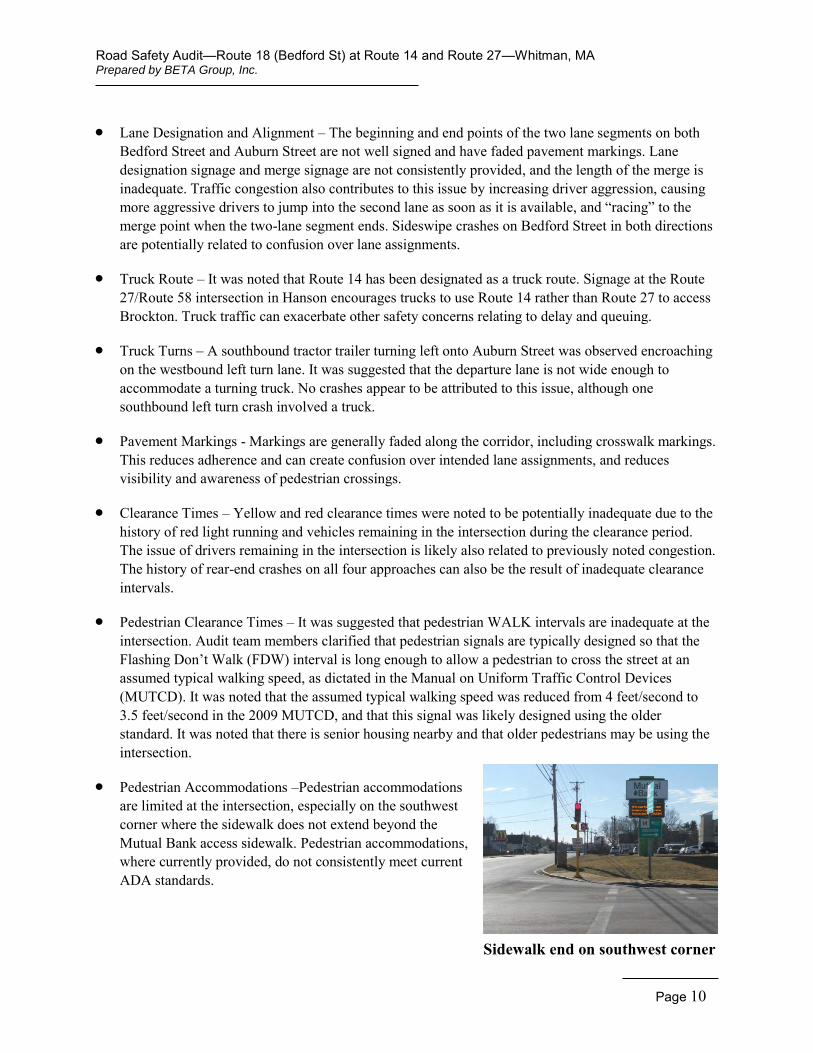
Pedestrian Accommodations –Pedestrian accommodations are limited at the intersection, especially on the southwest corner where the sidewalk does not extend beyond the Mutual Bank access sidewalk. Pedestrian accommodations, where currently provided, do not consistently meet current ADA standards.
Road Safety Audit—Route 18 (Bedford St) at Route 14 and Route 27—Whitman, MA Prepared by BETA Group, Inc.
Page 11
Low Wendy’s Signage
Bicycle Accommodation – Accommodation is not provided for bicycles at the intersection. Shoulders, where provided, are of an inadequate width for accommodation.
Speeding – Speeding is a safety concern at the intersection and on the intersection approaches.
Northbound Left Lane Queue – The lack of a protected movement for the Bedford Street northbound left turn results in queued vehicles waiting for a gap in southbound traffic. Northbound through vehicles were observed favoring the right lane, although through movements are allowed from both lanes, creating a de facto left turn lane on this approach. Sideswipe and rear-end crashes on this approach may be related to this issue. Sideswipe crashes may be the result of drivers changing lanes to avoid queued vehicles in the left lane, while rear-end crashes can occur when through drivers do not anticipate stopped vehicles during a green indication.
Signal Visibility – The Bedford Street southbound and Auburn Street westbound approaches have only one overhead signal, reducing signal visibility for approaching drivers. It was also noted that signs, utility poles and other roadside obstructions reduce visibility for post-mounted signals.
Approach Alignment – The Auburn Street eastbound approach does not align with the departure lanes. Audit participants noted that the approach directly aligns with the mast arm on the southeast corner, although it should be noted that no crashes involved vehicles striking the mast arm.
Sign Clutter –Multiple signs relating to intersection control and guidance are provided on all approaches to the intersection. The number of signs creates a visual clutter that reduces the driver’s ability to receive all the information presented when approaching the intersection.
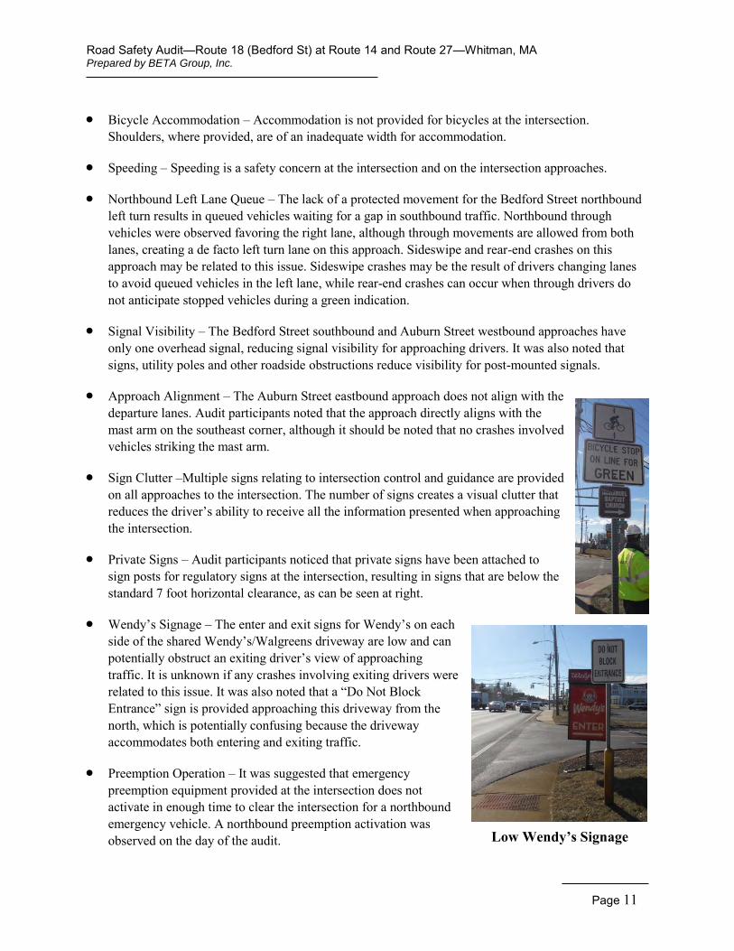
Private Signs – Audit participants noticed that private signs have been attached to sign posts for regulatory signs at the intersection, resulting in signs that are below the standard 7 foot horizontal clearance, as can be seen at right.
Wendy’s Signage – The enter and exit signs for Wendy’s on each side of the shared Wendy’s/Walgreens driveway are low and can potentially obstruct an exiting driver’s view of approaching traffic. It is unknown if any crashes involving exiting drivers were related to this issue. It was also noted that a “Do Not Block Entrance” sign is provided approaching this driveway from the north, which is potentially confusing because the driveway accommodates both entering and exiting traffic.
Preemption Operation – It was suggested that emergency preemption equipment provided at the intersection does not activate in enough time to clear the intersection for a northbound emergency vehicle. A northbound preemption activation was observed on the day of the audit.
Road Safety Audit—Route 18 (Bedford St) at Route 14 and Route 27—Whitman, MA Prepared by BETA Group, Inc.
Page 12
Missing Sign Post and Damaged Pole
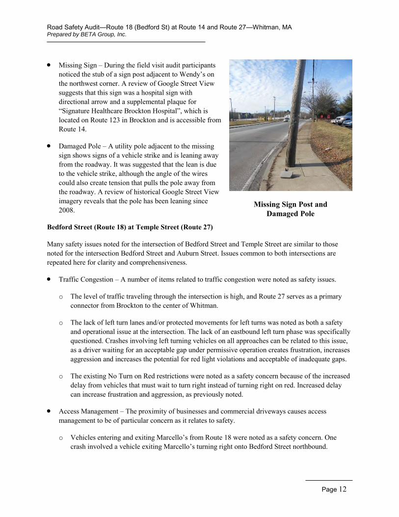
Missing Sign – During the field visit audit participants noticed the stub of a sign post adjacent to Wendy’s on the northwest corner. A review of Google Street View suggests that this sign was a hospital sign with directional arrow and a supplemental plaque for “Signature Healthcare Brockton Hospital”, which is located on Route 123 in Brockton and is accessible from Route 14.
Damaged Pole – A utility pole adjacent to the missing sign shows signs of a vehicle strike and is leaning away from the roadway. It was suggested that the lean is due to the vehicle strike, although the angle of the wires could also create tension that pulls the pole away from the roadway. A review of historical Google Street View imagery reveals that the pole has been leaning since 2008.
Bedford Street (Route 18) at Temple Street (Route 27)
Many safety issues noted for the intersection of Bedford Street and Temple Street are similar to those noted for the intersection Bedford Street and Auburn Street. Issues common to both intersections are repeated here for clarity and comprehensiveness.
Traffic Congestion – A number of items related to traffic congestion were noted as safety issues.
o The level of traffic traveling through the intersection is high, and Route 27 serves as a primary connector from Brockton to the center of Whitman.
o The lack of left turn lanes and/or protected movements for left turns was noted as both a safety and operational issue at the intersection. The lack of an eastbound left turn phase was specifically questioned. Crashes involving left turning vehicles on all approaches can be related to this issue, as a driver waiting for an acceptable gap under permissive operation creates frustration, increases aggression and increases the potential for red light violations and acceptable of inadequate gaps.
o The existing No Turn on Red restrictions were noted as a safety concern because of the increased delay from vehicles that must wait to turn right instead of turning right on red. Increased delay can increase frustration and aggression, as previously noted.
Access Management – The proximity of businesses and commercial driveways causes access management to be of particular concern as it relates to safety.
o Vehicles entering and exiting Marcello’s from Route 18 were noted as a safety concern. One crash involved a vehicle exiting Marcello’s turning right onto Bedford Street northbound.
Road Safety Audit—Route 18 (Bedford St) at Route 14 and Route 27—Whitman, MA Prepared by BETA Group, Inc.
Page 13
Plaza Exit on Temple Street
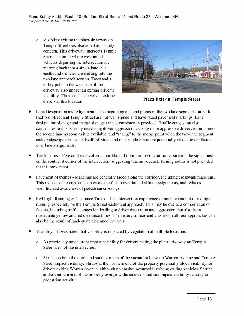
o Visibility exiting the plaza driveway on Temple Street was also noted as a safety concern. This driveway intersects Temple Street at a point where westbound vehicles departing the intersection are merging back into a single lane, but eastbound vehicles are shifting into the two lane approach section. Trees and a utility pole on the west side of the driveway also impact an exiting driver’s visibility. Three crashes involved exiting drivers at this location.
Lane Designation and Alignment – The beginning and end points of the two lane segments on both Bedford Street and Temple Street are not well signed and have faded pavement markings. Lane designation signage and merge signage are not consistently provided. Traffic congestion also contributes to this issue by increasing driver aggression, causing more aggressive drivers to jump into the second lane as soon as it is available, and “racing” to the merge point when the two-lane segment ends. Sideswipe crashes on Bedford Street and on Temple Street are potentially related to confusion over lane assignments.
Truck Turns – Five crashes involved a northbound right turning tractor trailer striking the signal post on the southeast corner of the intersection, suggesting that an adequate turning radius is not provided for this movement.
Pavement Markings - Markings are generally faded along the corridor, including crosswalk markings. This reduces adherence and can create confusion over intended lane assignments, and reduces visibility and awareness of pedestrian crossings.
Red Light Running & Clearance Times – The intersection experiences a notable amount of red light running, especially on the Temple Street eastbound approach. This may be due to a combination of factors, including traffic congestion leading to driver frustration and aggression, but also from inadequate yellow and red clearance times. The history of rear-end crashes on all four approaches can also be the result of inadequate clearance intervals.
Visibility – It was noted that visibility is impacted by vegetation at multiple locations.
o As previously noted, trees impact visibility for drivers exiting the plaza driveway on Temple Street west of the intersection.
o Shrubs on both the north and south corners of the vacant lot between Warren Avenue and Temple Street impact visibility. Shrubs at the northern end of the property potentially block visibility for drivers exiting Warren Avenue, although no crashes occurred involving exiting vehicles. Shrubs at the southern end of the property overgrow the sidewalk and can impact visibility relating to pedestrian activity.
Road Safety Audit—Route 18 (Bedford St) at Route 14 and Route 27—Whitman, MA Prepared by BETA Group, Inc.
Page 14
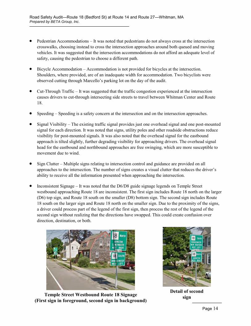
Temple Street Westbound Route 18 Signage (First sign in foreground, second sign in background)
Detail of second sign
Pedestrian Accommodations – It was noted that pedestrians do not always cross at the intersection crosswalks, choosing instead to cross the intersection approaches around both queued and moving vehicles. It was suggested that the intersection accommodations do not afford an adequate level of safety, causing the pedestrian to choose a different path.
Bicycle Accommodation – Accommodation is not provided for bicycles at the intersection. Shoulders, where provided, are of an inadequate width for accommodation. Two bicyclists were observed cutting through Marcello’s parking lot on the day of the audit.
Cut-Through Traffic – It was suggested that the traffic congestion experienced at the intersection causes drivers to cut-through intersecting side streets to travel between Whitman Center and Route 18.
Speeding – Speeding is a safety concern at the intersection and on the intersection approaches.
Signal Visibility – The existing traffic signal provides just one overhead signal and one post-mounted signal for each direction. It was noted that signs, utility poles and other roadside obstructions reduce visibility for post-mounted signals. It was also noted that the overhead signal for the eastbound approach is tilted slightly, further degrading visibility for approaching drivers. The overhead signal head for the eastbound and northbound approaches are free swinging, which are more susceptible to movement due to wind.
Sign Clutter – Multiple signs relating to intersection control and guidance are provided on all approaches to the intersection. The number of signs creates a visual clutter that reduces the driver’s ability to receive all the information presented when approaching the intersection.
Inconsistent Signage – It was noted that the D6/D8 guide signage legends on Temple Street westbound approaching Route 18 are inconsistent. The first sign includes Route 18 north on the larger (D6) top sign, and Route 18 south on the smaller (D8) bottom sign. The second sign includes Route 18 south on the larger sign and Route 18 north on the smaller sign. Due to the proximity of the signs, a driver could process part of the legend of the first sign, then process the rest of the legend of the second sign without realizing that the directions have swapped. This could create confusion over direction, destination, or both.
Road Safety Audit—Route 18 (Bedford St) at Route 14 and Route 27—Whitman, MA Prepared by BETA Group, Inc.
Page 15
Street Name Signs – No street name signs are provided at the intersection.
Signal Equipment – An audit participant suggested that the back loop on the Temple Street westbound approach is not working. A vehicle was observed stopped a distance behind the stop line, which did not call the green phase for the approach. It was also noted during the field visit that a pedestrian signal head on the southwest corner is misaligned.
Pavement Rutting – Pavement condition was noted as a potential safety issue. Rutting is most significant on the northbound approach.
Signal Coordination – The potential for signal coordination between the two study intersections was debated by the audit team. The MUTCD suggests that “traffic control signals within 1/2 mile of one another along a major route or in a network of intersecting major routes should be coordinated, preferably with interconnected controller units.” Route 14 and Route 27 are approximately ¾ mile apart and have a significant number of businesses and side streets between them that interrupt continuous flow, suggesting that coordination would not be beneficial at these locations.
Road Safety Audit—Route 18 (Bedford St) at Route 14 and Route 27—Whitman, MA Prepared by BETA Group, Inc.
Page 16
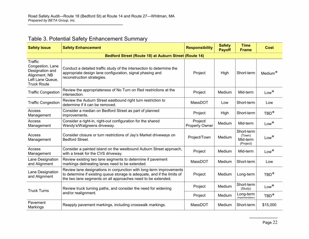
Potential Safety Enhancements Following review of available materials and a discussion of existing safety issues, audit participants were asked to consider improvements. Audit participants were encouraged to consider both short and long term improvements for each issue. Each improvement considered has been categorized as short-term, mid-term, or long-term based on the definitions shown in Table 2. Additionally, a cost category has been assigned to each improvement based on the parameters set forth in Table 2.
Table 2. Estimated Time Frame and Costs Breakdown Time Frame Costs
Short-term <1 year Low <$10,000 Mid-term 1–3 years Medium $10,000–$50,000
Long-term >3 years High >$50,000
Bedford Street (Route 18) at Auburn Street (Route 14)
Conduct a detailed traffic study of the intersection to determine the appropriate design lane configuration, signal phasing and reconstruction strategies. A traffic study is the first step towards improvements aimed at addressing congestion, traffic signal improvements, and geometric improvements. The feasibility and appropriateness of protected left turn movements will be considered for all approaches. The study should also consider the impact of truck traffic on the intersection operation. This is a short term, medium cost improvement that will be completed as part of planned improvements.
Review the appropriateness of No Turn on Red restrictions at the intersection. The project design will consider the need for turn restrictions during the red indication, and implement restrictions only where they are determined to be necessary for safe operation. This is a mid-term, low cost improvement that will be completed as part of the project design.
Review the Auburn Street eastbound right turn restriction to determine if it can be removed. Audit participants noted that MassDOT agreed to remove this restriction several years ago. MassDOT District personnel should review the appropriateness of the existing restriction. This is a short-term, low cost improvement.
Consider a median on Bedford Street as part of planned improvements. A median was suggested to assist in delineation of travel lanes, but also to prohibit left turns from adjacent commercial driveways. This would require drivers exiting Wendy’s or Jay’s Market to turn right onto Bedford Street, or to use the Auburn Street driveways and turn left at the traffic signal. It was suggested that blocking left turns from the shared Wendy’s/Walgreens driveway could relocate those lefts to the northern Walgreeens driveway. This is a mid-term, low cost improvement that will be considered as part of the project design process.
Consider a right-in, right-out configuration for the shared Wendy’s/Walgreens driveway. Restricting left turns in and out at this location would eliminate conflicts that contribute to the crash history of the
Road Safety Audit—Route 18 (Bedford St) at Route 14 and Route 27—Whitman, MA Prepared by BETA Group, Inc.
Page 17
intersection. As noted above, restricting left turns from the shared driveway could relocate those lefts to the northern Walgreeens driveway. This restriction would require coordination with the property owner(s). This is a mid-term, low cost improvement that will be considered as part of the project design process.
Consider closure or turn restrictions of Jay’s Market driveways on Bedford Street. This potential modification will be reviewed in conjunction with project improvements and in conjunction with local review relating to the potential gas pump expansion. This is a short-term, low cost improvement.
Consider a painted island on the westbound Auburn Street approach with a break for the CVS driveway. This potential improvement will be considered as part of project improvements. It was noted that intersection improvements could increase approach capacity, which would reduce queues and eliminate the need for vehicles to bypass the existing queue to enter CVS.
Review existing two lane segments to determine if pavement markings delineating lanes need to be extended. Vehicles have been observed forming two lanes before the beginning of the marked two-lane section. A cursory review suggests that markings are properly placed, suggesting that driver behavior is due to driver aggression; however, markings should be reviewed as a short-term, low cost improvement in conjunction with reapplication of pavement markings.
Review lane designations in conjunction with long term improvements to determine if existing queue storage is adequate, and if the limits of the two lane segments on all approaches need to be extended. This is a long-term improvement that will be considered as part of the project design process.
Review truck turning paths, and consider the need for widening and/or realignment. This is of specific concern for the Bedford Street southbound left turn, but should be reviewed for all turning movements. Review of turning paths is a short-term improvement, while widening and/or realignment is a long-term, potentially high cost improvement.
Reapply pavement markings, including crosswalk markings. This will increase adherence to intended lane assignments and increase visibility of crosswalk locations. The audit team suggested that ladder-style crosswalk markings are more visible for approaching vehicles and should be considered at this location. This is a short-term, medium cost improvement.
Study clearance times, and update if necessary. The existing yellow and all red clearance times should be determined from the existing traffic signal controller and compared to minimum requirements calculated based on the latest ITE and MassDOT guidance. If existing clearance times are insufficient, clearance times should be increased accordingly. This change in clearance times could reduce the number of rear-end crashes occurring at the intersection. This is a short-term, low cost improvement.
Review pedestrian clearance times, and update if necessary. Pedestrian clearance times should be calculated based on the latest MUTCD and MassDOT guidance. This is a short-term, medium cost improvement.
Road Safety Audit—Route 18 (Bedford St) at Route 14 and Route 27—Whitman, MA Prepared by BETA Group, Inc.
Page 18
Provide countdown pedestrian signal heads in conjunction with planned improvements. Countdown heads display the time remaining in the Flashing Don’t Walk interval, and can help pedestrians decide whether they have adequate time to cross the street. This is a long-term, low cost improvement.
Implement educational programs for neighboring senior citizens regarding pedestrian safety. An educational program can clarify that the Walk phase means it is safe to enter the intersection, and that a pedestrian that enters at the beginning of the Flashing Don’t Walk phase will have adequate time to cross the street. Education is a short-term, low cost improvement that should be implemented only after pedestrian intervals have been reviewed for compliance with current standards.
Reconstruct sidewalks and provide ADA compliant wheelchair ramps. Sidewalk reconstruction will be completed long-term in conjunction with planned improvements. Sidewalk should be extended to the limits of work on all legs of the intersection where feasible, in conformance with MassDOT’s Healthy Transportation Policy and Complete Streets guidelines.
Widen shoulders. The intersecting roadways should be widened to provide minimum 5-foot shoulders where feasible as part of the planned improvements. This mid-term, high cost improvement will provide additional pavement width for turning vehicles and will meet MassDOT’s standard for bicycle accommodation.
Continue to enforce speeding and red light running in the vicinity of the intersection. Enforcement is a short-term and ongoing improvement, the cost of which is reduced enforcement elsewhere in Town.
Upgrade signals to provide overhead signals with retroreflective backplates, and add supplemental heads where appropriate to increase visibility. This is a long-term, high cost improvement assumed to be incorporated into the proposed project. The upgraded signal should be fully actuated with detection on all approaches.
Realign the Auburn Street eastbound through movement to the greatest extent practical as part of planned improvements. Through alignments on all approaches should be reviewed to maintain a consistent alignment. This is a long-term improvement.
Review signs and remove inappropriate, incorrect or ambiguous signage. Despite recommendations for increased signage for specific safety concerns, it was noted that existing signage is sometimes cluttered and ineffective. A complete review of existing signage should be done as part of the project. This is a long-term improvement.
Remove private signs for Emmanuel Baptist Church. These signs do not provide the required horizontal clearance and contribute to overall sign clutter. This is a short-term, low cost improvement.
Remove and/or relocate low Wendy’s enter and exit signs. Sight triangles should be reviewed to determine if the signs can be relocated to eliminate the visibility obstruction. This is a short-term, low cost improvement that should be coordinated with the property owner.
Replace “Do Not Block Entrance” sign with “Do Not Block Driveway” sign. This short-term, low cost improvement is recommended to deliver a clearer message to approaching drivers.
Road Safety Audit—Route 18 (Bedford St) at Route 14 and Route 27—Whitman, MA Prepared by BETA Group, Inc.
Page 19
Review preemption equipment locations in conjunction with planned improvements. Detectors should be located to maximize early detection. This is a long-term, low cost improvement.
Replace sign for Brockton Hospital. The missing sign on the northwest corner of the intersection should be replaced in kind. This is a short-term, low cost improvement.
Review utility pole locations and condition in conjunction with planned improvements. This is a long-term, potentially high cost improvement if pole replacements and/or relocations are required. This improvement must be coordinated with the affected utility companies.
Bedford Street (Route 18) at Temple Street (Route 27)
Conduct a detailed traffic study of the intersection to determine the appropriate design lane configuration, signal phasing and reconstruction strategies. A traffic study is the first step towards improvements aimed at addressing congestion, traffic signal improvements, and geometric improvements. The feasibility and appropriateness of protected left turn movements will be considered for all approaches. The study should also quantify cut-through traffic currently avoiding the intersection, and consider its impact if redirected through the intersection. This is a short term, medium cost improvement that will be completed as part of planned improvements. Improving capacity at the intersection can also reduce cut-through traffic on side streets.
Review the appropriateness of No Turn on Red restrictions at the intersection. The project design will consider the need for turn restrictions during the red indication, and implement restrictions only where they are determined to be necessary for safe operation. This is a mid-term, low cost improvement that will be completed as part of the project design.
Consider a right-in, right-out configuration for the Cumberland Farms driveway closest to the intersection on Bedford Street. Restricting left turns in and out at this location would eliminate conflicts that contribute to the crash history of the intersection. This restriction would require coordination with the property owner(s). This is a mid-term, low cost improvement that will be considered as part of the project design process.
Review sight triangles for the plaza driveway on Temple Street. Trim or remove vegetation and relocate utility pole if necessary. This is a mid-term, low cost improvement that will be considered as part of the design process.
Review the Temple Street cross-section at the plaza driveway, and consider shortening the two-lane segment so that vehicles departing the plaza only need to cross one lane of approach traffic. This long-term improvement will be considered along with other operational improvements at the intersection.
Trim shrubs bordering the vacant lot between Temple Street and Warren Avenue. This is a short-term, low cost improvement.
Review existing two lane segments to determine if pavement markings delineating lanes need to be extended. Vehicles have been observed forming two lanes before the beginning of the marked two-
Road Safety Audit—Route 18 (Bedford St) at Route 14 and Route 27—Whitman, MA Prepared by BETA Group, Inc.
Page 20
lane section. Markings should be reviewed as a short-term, low cost improvement in conjunction with reapplication of pavement markings.
Review lane designations in conjunction with long term improvements to determine if existing queue storage is adequate, and if the limits of the two lane segments on all approaches need to be extended. This is a long-term improvement that will be considered as part of the project design process.
Review truck turning paths, and consider the need for widening and/or realignment. This is of specific concern for the Bedford Street northbound right turn, but should be reviewed for all turning movements. Review of turning paths is a short-term improvement, while widening and/or realignment is a long-term, potentially high cost improvement.
Reapply pavement markings, including crosswalk markings. This will increase adherence to intended lane assignments and increase visibility of crosswalk locations. The audit team suggested that ladder-style crosswalk markings are more visible for approaching vehicles and should be considered at this location. This is a short-term, medium cost improvement.
Study clearance times, and update if necessary. The existing yellow and all red clearance times should be determined from the existing traffic signal controller and compared to minimum requirements calculated based on the latest ITE and MassDOT guidance. If existing clearance times are insufficient, clearance times should be increased accordingly. This change in clearance times could reduce the number of rear-end crashes occurring at the intersection. This is a short-term, low cost improvement.
Review pedestrian clearance times, and update if necessary. Pedestrian clearance times should be calculated based on the latest MUTCD and MassDOT guidance. This is a short-term, low cost improvement.
Provide countdown pedestrian signal heads in conjunction with planned improvements. Countdown heads display the time remaining in the Flashing Don’t Walk interval, and can help pedestrians decide whether they have adequate time to cross the street. This is a long-term, low cost improvement.
Reconstruct sidewalks and provide ADA compliant wheelchair ramps. Sidewalk reconstruction will be completed long-term in conjunction with planned improvements. Sidewalk should be extended to the limits of work on all legs of the intersection where feasible, in conformance with MassDOT’s Healthy Transportation Policy and Complete Streets guidelines.
Widen shoulders. The intersecting roadways should be widened to provide minimum 5-foot shoulders where feasible as part of the planned improvements. This mid-term, high cost improvement will provide additional pavement width for turning vehicles and will meet MassDOT’s standard for bicycle accommodation.
Continue to enforce speeding and red light running in the vicinity of the intersection. Enforcement is a short-term and ongoing improvement, the cost of which is reduced enforcement elsewhere in Town.
Road Safety Audit—Route 18 (Bedford St) at Route 14 and Route 27—Whitman, MA Prepared by BETA Group, Inc.
Page 21
Upgrade signals to provide overhead signals with retroreflective backplates, and add supplemental heads where appropriate to increase visibility. This is a long-term, high cost improvement assumed to be incorporated into the proposed project. The upgraded signal should be fully actuated with detection on all approaches.
Review signs and remove inappropriate, incorrect or ambiguous signage. Despite recommendations for increased signage for specific safety concerns, it was noted that existing signage is sometimes cluttered and ineffective. A complete review of existing signage should be done as part of the project. This is a long-term improvement.
Install street name signs at the intersection. Street name signs should be provided for both Bedford Street and Temple Street. This is a short-term, low cost improvement.
Determine if loops on Temple Street are working properly, and repair if necessary. This is a short-term, low cost improvement.
Rehabilitate pavement. Pavement should be rehabilitated at the intersection. The appropriate method of pavement rehabilitation should be determined based on the results of subsurface exploration. This is a long-term, high cost improvement assumed to be included in the planned reconstruction project.
Summary of Road Safety Audit Table 3 summarizes potential recommendations discussed by the audit team. The recommendations are categorized based on the potential safety payoff, as well as by time frame and cost. The safety payoff is a qualitative judgment of the effectiveness of the potential safety improvements. Each recommendation has a responsibility assigned to it stating whether MassDOT or the Town of Whitman would be responsible for implementing the recommended improvement. The term “Project” refers to improvements that are assumed to be included or could reasonably be accommodated as part of planned improvements.
Road Safety Audit—Route 18 (Bedford St) at Route 14 and Route 27—Whitman, MA Prepared by BETA Group, Inc.
Page 22
Table 3. Potential Safety Enhancement Summary Safety Issue Safety Enhancement Responsibility Safety
Payoff Time
Frame Cost
Bedford Street (Route 18) at Auburn Street (Route 14) Traffic Congestion, Lane Designation and Alignment, NB Left Lane Queue, Truck Route
Conduct a detailed traffic study of the intersection to determine the appropriate design lane configuration, signal phasing and reconstruction strategies.
Project High Short-term Medium*
Traffic Congestion Review the appropriateness of No Turn on Red restrictions at the intersection. Project Medium Mid-term Low*
Traffic Congestion Review the Auburn Street eastbound right turn restriction to determine if it can be removed. MassDOT Low Short-term Low
Access Management
Consider a median on Bedford Street as part of planned improvements. Project High Short-term TBD*
Access Management
Consider a right-in, right-out configuration for the shared Wendy’s/Walgreens driveway.
Project/ Property Owner Medium Mid-term Low*
Access Management
Consider closure or turn restrictions of Jay’s Market driveways on Bedford Street. Project/Town Medium
Short-term (Town)
Mid-term (Project)
Low*
Access Management
Consider a painted island on the westbound Auburn Street approach, with a break for the CVS driveway. Project Medium Mid-term Low*
Lane Designation and Alignment
Review existing two lane segments to determine if pavement markings delineating lanes need to be extended. MassDOT Medium Short-term Low
Lane Designation and Alignment
Review lane designations in conjunction with long-term improvements to determine if existing queue storage is adequate, and if the limits of the two lane segments on all approaches need to be extended.
Project Medium Long-term TBD*
Truck Turns Review truck turning paths, and consider the need for widening and/or realignment.
Project Medium Short-term (Study) Low*
Project Medium Long-term (Implementation) TBD*
Pavement Markings Reapply pavement markings, including crosswalk markings. MassDOT Medium Short-term $15,000
Road Safety Audit—Route 18 (Bedford St) at Route 14 and Route 27—Whitman, MA Prepared by BETA Group, Inc.
Page 23
Table 3. Potential Safety Enhancement Summary Safety Issue Safety Enhancement Responsibility Safety
Payoff Time
Frame Cost
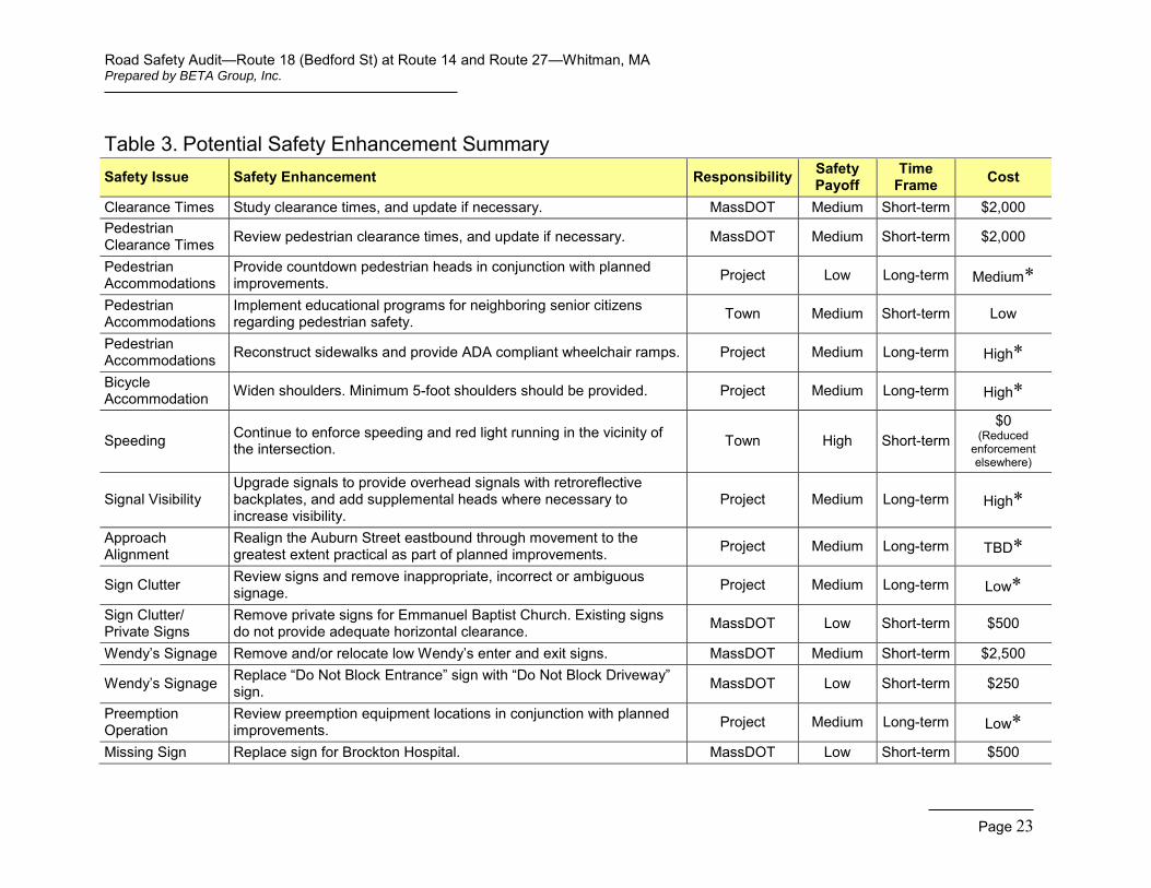
Clearance Times Study clearance times, and update if necessary. MassDOT Medium Short-term $2,000 Pedestrian Clearance Times Review pedestrian clearance times, and update if necessary. MassDOT Medium Short-term $2,000
Pedestrian Accommodations
Provide countdown pedestrian heads in conjunction with planned improvements. Project Low Long-term Medium*
Pedestrian Accommodations
Implement educational programs for neighboring senior citizens regarding pedestrian safety. Town Medium Short-term Low
Pedestrian Accommodations Reconstruct sidewalks and provide ADA compliant wheelchair ramps. Project Medium Long-term High*
Bicycle Accommodation Widen shoulders. Minimum 5-foot shoulders should be provided. Project Medium Long-term High*
Speeding Continue to enforce speeding and red light running in the vicinity of the intersection. Town High Short-term
$0 (Reduced
enforcement elsewhere)
Signal Visibility Upgrade signals to provide overhead signals with retroreflective backplates, and add supplemental heads where necessary to increase visibility.
Project Medium Long-term High*
Approach Alignment
Realign the Auburn Street eastbound through movement to the greatest extent practical as part of planned improvements. Project Medium Long-term TBD*
Sign Clutter Review signs and remove inappropriate, incorrect or ambiguous signage. Project Medium Long-term Low*
Sign Clutter/ Private Signs
Remove private signs for Emmanuel Baptist Church. Existing signs do not provide adequate horizontal clearance. MassDOT Low Short-term $500
Wendy’s Signage Remove and/or relocate low Wendy’s enter and exit signs. MassDOT Medium Short-term $2,500
Wendy’s Signage Replace “Do Not Block Entrance” sign with “Do Not Block Driveway” sign. MassDOT Low Short-term $250
Preemption Operation
Review preemption equipment locations in conjunction with planned improvements. Project Medium Long-term Low*
Missing Sign Replace sign for Brockton Hospital. MassDOT Low Short-term $500
Road Safety Audit—Route 18 (Bedford St) at Route 14 and Route 27—Whitman, MA Prepared by BETA Group, Inc.
Page 24
Table 3. Potential Safety Enhancement Summary Safety Issue Safety Enhancement Responsibility Safety
Payoff Time
Frame Cost
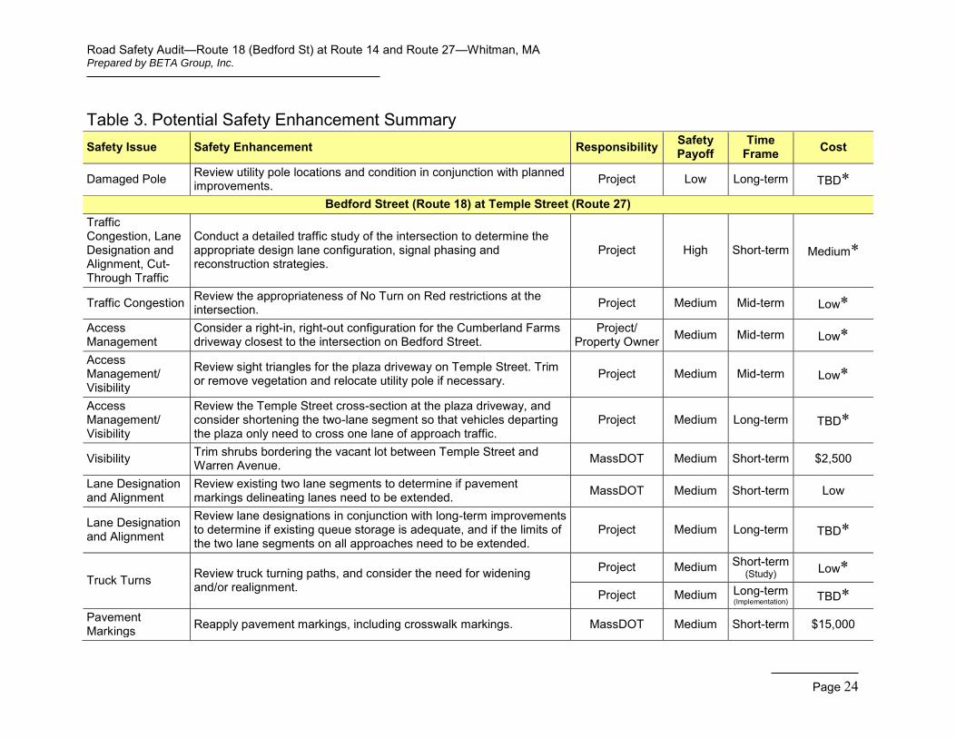
Damaged Pole Review utility pole locations and condition in conjunction with planned improvements. Project Low Long-term TBD*
Bedford Street (Route 18) at Temple Street (Route 27) Traffic Congestion, Lane Designation and Alignment, Cut-Through Traffic
Conduct a detailed traffic study of the intersection to determine the appropriate design lane configuration, signal phasing and reconstruction strategies.
Project High Short-term Medium*
Traffic Congestion Review the appropriateness of No Turn on Red restrictions at the intersection. Project Medium Mid-term Low*
Access Management
Consider a right-in, right-out configuration for the Cumberland Farms driveway closest to the intersection on Bedford Street.
Project/ Property Owner Medium Mid-term Low*
Access Management/ Visibility
Review sight triangles for the plaza driveway on Temple Street. Trim or remove vegetation and relocate utility pole if necessary. Project Medium Mid-term Low*
Access Management/ Visibility
Review the Temple Street cross-section at the plaza driveway, and consider shortening the two-lane segment so that vehicles departing the plaza only need to cross one lane of approach traffic.
Project Medium Long-term TBD*
Visibility Trim shrubs bordering the vacant lot between Temple Street and Warren Avenue. MassDOT Medium Short-term $2,500
Lane Designation and Alignment
Review existing two lane segments to determine if pavement markings delineating lanes need to be extended. MassDOT Medium Short-term Low
Lane Designation and Alignment
Review lane designations in conjunction with long-term improvements to determine if existing queue storage is adequate, and if the limits of the two lane segments on all approaches need to be extended.
Project Medium Long-term TBD*
Truck Turns Review truck turning paths, and consider the need for widening and/or realignment.
Project Medium Short-term (Study) Low*
Project Medium Long-term (Implementation) TBD*
Pavement Markings Reapply pavement markings, including crosswalk markings. MassDOT Medium Short-term $15,000
Road Safety Audit—Route 18 (Bedford St) at Route 14 and Route 27—Whitman, MA Prepared by BETA Group, Inc.
Page 25
Table 3. Potential Safety Enhancement Summary Safety Issue Safety Enhancement Responsibility Safety
Payoff Time
Frame Cost
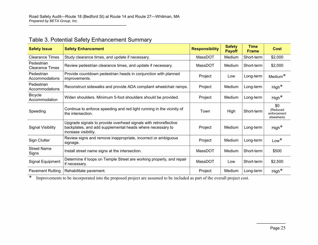
Clearance Times Study clearance times, and update if necessary. MassDOT Medium Short-term $2,000 Pedestrian Clearance Times Review pedestrian clearance times, and update if necessary. MassDOT Medium Short-term $2,000
Pedestrian Accommodations
Provide countdown pedestrian heads in conjunction with planned improvements. Project Low Long-term Medium*
Pedestrian Accommodations Reconstruct sidewalks and provide ADA compliant wheelchair ramps. Project Medium Long-term High*
Bicycle Accommodation Widen shoulders. Minimum 5-foot shoulders should be provided. Project Medium Long-term High*
Speeding Continue to enforce speeding and red light running in the vicinity of the intersection. Town High Short-term
$0 (Reduced
enforcement elsewhere)
Signal Visibility Upgrade signals to provide overhead signals with retroreflective backplates, and add supplemental heads where necessary to increase visibility.
Project Medium Long-term High*
Sign Clutter Review signs and remove inappropriate, incorrect or ambiguous signage. Project Medium Long-term Low*
Street Name Signs Install street name signs at the intersection. MassDOT Medium Short-term $500
Signal Equipment Determine if loops on Temple Street are working properly, and repair if necessary. MassDOT Low Short-term $2,500
Pavement Rutting Rehabilitate pavement. Project Medium Long-term High*
* Improvements to be incorporated into the proposed project are assumed to be included as part of the overall project cost.
Road Safety Audit—Route 18 (Bedford St) at Route 14 and Route 27—Whitman, MA Prepared by BETA Group, Inc.
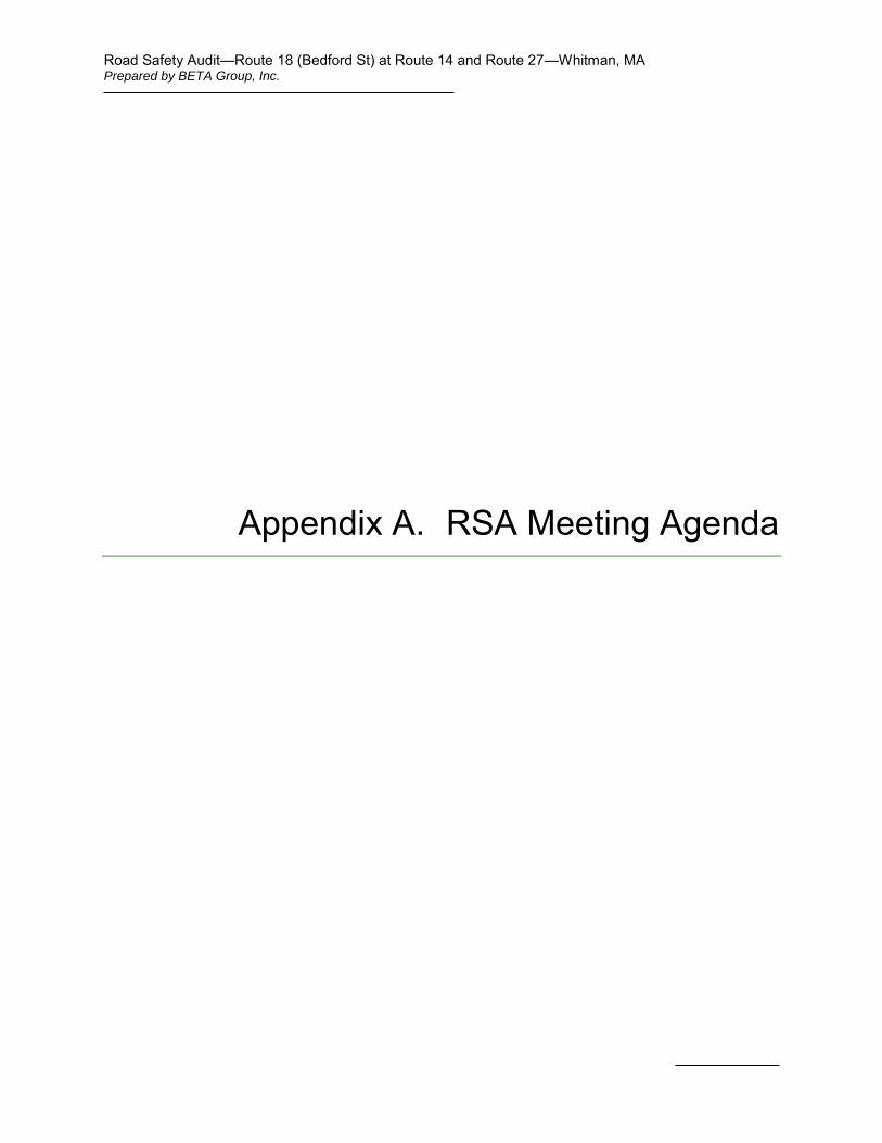
Appendix A. RSA Meeting Agenda
Road Safety Audit Whitman, MA
Bedford Street (Route 18) at Auburn St (Route 14) & Temple St (Route 27)
Meeting Location: Whitman Town Hall, Selectmen’s Room 54 South Avenue, Whitman, MA
Tuesday, January 20, 2015 9:30 AM – 12:00 PM
Type of meeting: High Crash Location – Road Safety Audit Attendees: Invited Participants to Comprise a Multidisciplinary Team Please bring: Thoughts and Enthusiasm!!
9:30 AM Welcome and Introductions
9:45 AM Discussion of Safety Issues
Crash history, Speed Regulations – provided in advance
Existing Geometries and Conditions
10:30 AM Site Visit Drive to the intersections of Bedford St at Auburn St and Temple St
As a group, identify areas for improvement
11:00 AM Discussion of Potential Improvements Discuss observations and finalize safety issue areas
Discuss potential improvements and finalize recommendations
12:00 PM Adjourn for the Day – but the RSA has not ended
Instructions for Participants:
Before attending the RSA on January 20th, participants are encouraged to drive/walk through the intersection and complete/consider elements on the RSA Prompt List with a focus on safety.
All participants will be actively involved in the process throughout. Participants are encouraged to come with thoughts and ideas, but are reminded that the synergy that develops and respect for others’ opinions are key elements to the success of the overall RSA process.
After the RSA meeting, participants will be asked to comment and respond to the document materials to assure it is reflective of the RSA completed by the multidisciplinary team.
Road Safety Audit—Route 18 (Bedford St) at Route 14 and Route 27—Whitman, MA Prepared by BETA Group, Inc.
Appendix B. RSA Audit Team Contact List
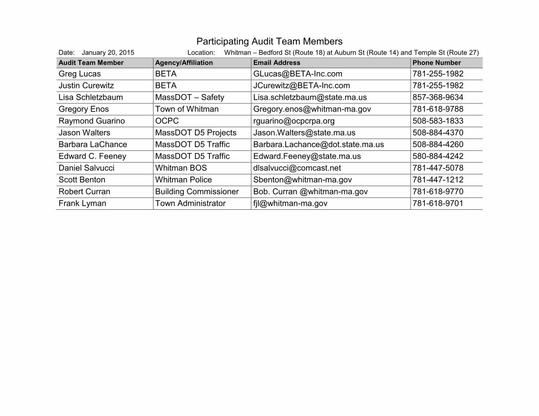
Participating Audit Team Members Date: January 20, 2015 Location: Whitman – Bedford St (Route 18) at Auburn St (Route 14) and Temple St (Route 27) Audit Team Member Agency/Affiliation Email Address Phone Number Greg Lucas BETA [email protected] 781-255-1982 Justin Curewitz BETA [email protected] 781-255-1982 Lisa Schletzbaum MassDOT – Safety [email protected] 857-368-9634 Gregory Enos Town of Whitman [email protected] 781-618-9788 Raymond Guarino OCPC [email protected] 508-583-1833 Jason Walters MassDOT D5 Projects [email protected] 508-884-4370 Barbara LaChance MassDOT D5 Traffic [email protected] 508-884-4260 Edward C. Feeney MassDOT D5 Traffic [email protected] 580-884-4242 Daniel Salvucci Whitman BOS [email protected] 781-447-5078 Scott Benton Whitman Police [email protected] 781-447-1212 Robert Curran Building Commissioner Bob. Curran @whitman-ma.gov 781-618-9770 Frank Lyman Town Administrator [email protected] 781-618-9701
Road Safety Audit—Route 18 (Bedford St) at Route 14 and Route 27—Whitman, MA Prepared by BETA Group, Inc.
Appendix C. Detailed Crash Data
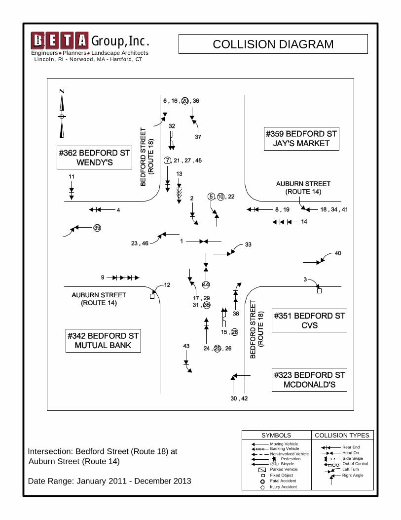
SYMBOLS COLLISION TYPESMoving VehicleBacking VehicleNon-Involved Vehicle
Parked VehicleFixed ObjectFatal AccidentInjury Accident
Rear EndHead OnSide SwipeOut of ControlLeft TurnRight Angle
BicyclePedestrian
Intersection: Bedford Street (Route 18) atAuburn Street (Route 14)
Date Range: January 2011 - December 2013
Group, Inc.L i nco l n , R I - N orwood , MA - Hartford , CT
Engineers Planners Landscape ArchitectsCOLLISION DIAGRAM
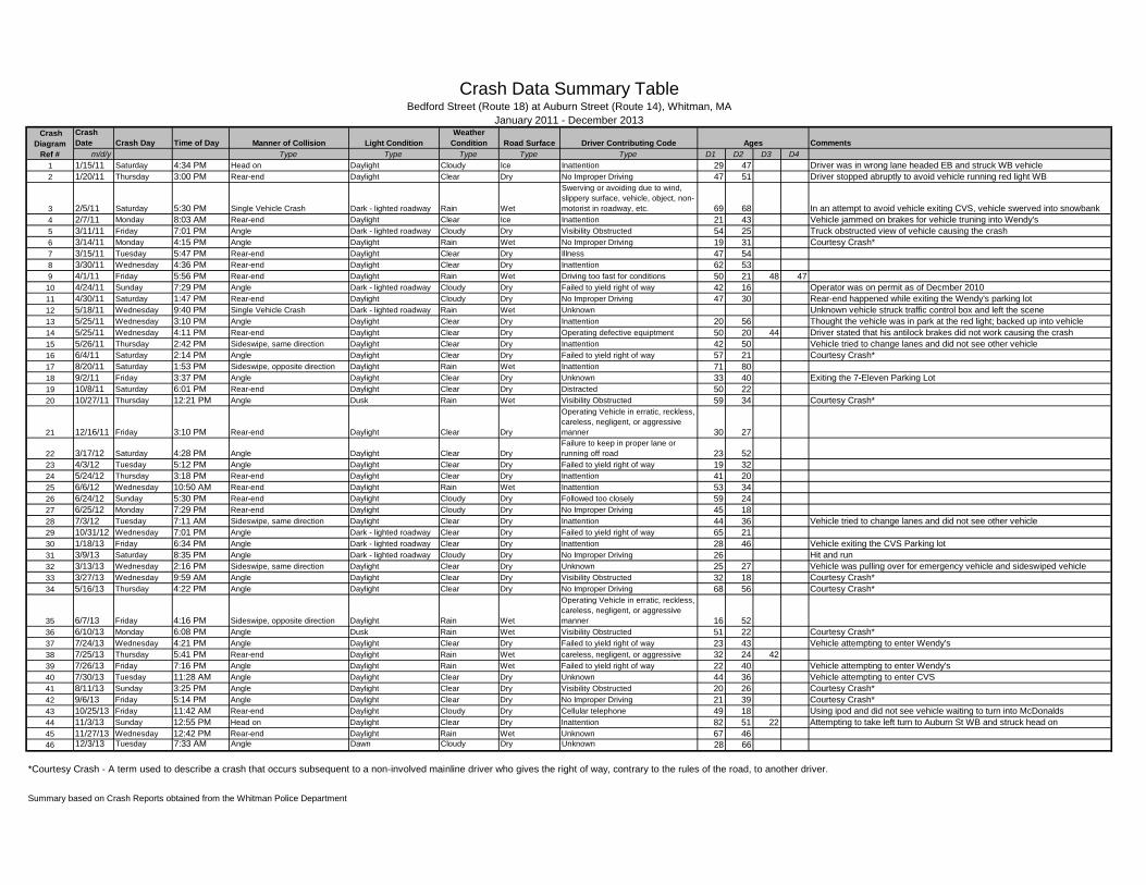
CrashDate Crash Day Time of Day Comments
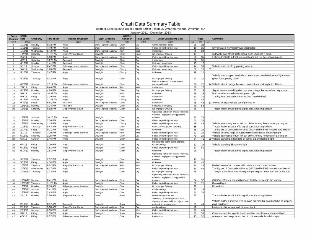
m/d/y Type Type Type Type Type D1 D2 D3 D41 1/15/11 Saturday 4:34 PM Head on Daylight Cloudy Ice Inattention 29 47 Driver was in wrong lane headed EB and struck WB vehicle2 1/20/11 Thursday 3:00 PM Rear-end Daylight Clear Dry No Improper Driving 47 51 Driver stopped abruptly to avoid vehicle running red light WB
3 2/5/11 Saturday 5:30 PM Single Vehicle Crash Dark - lighted roadway Rain Wet
Swerving or avoiding due to wind,slippery surface, vehicle, object, non-motorist in roadway, etc. 69 68 In an attempt to avoid vehicle exiting CVS, vehicle swerved into snowbank
4 2/7/11 Monday 8:03 AM Rear-end Daylight Clear Ice Inattention 21 43 Vehicle jammed on brakes for vehicle truning into Wendy's5 3/11/11 Friday 7:01 PM Angle Dark - lighted roadway Cloudy Dry Visibility Obstructed 54 25 Truck obstructed view of vehicle causing the crash6 3/14/11 Monday 4:15 PM Angle Daylight Rain Wet No Improper Driving 19 31 Courtesy Crash*7 3/15/11 Tuesday 5:47 PM Rear-end Daylight Clear Dry Illness 47 548 3/30/11 Wednesday 4:36 PM Rear-end Daylight Clear Dry Inattention 62 539 4/1/11 Friday 5:56 PM Rear-end Daylight Rain Wet Driving too fast for conditions 50 21 48 47
10 4/24/11 Sunday 7:29 PM Angle Dark - lighted roadway Cloudy Dry Failed to yield right of way 42 16 Operator was on permit as of Decmber 201011 4/30/11 Saturday 1:47 PM Rear-end Daylight Cloudy Dry No Improper Driving 47 30 Rear-end happened while exiting the Wendy's parking lot12 5/18/11 Wednesday 9:40 PM Single Vehicle Crash Dark - lighted roadway Rain Wet Unknown Unknown vehicle struck traffic control box and left the scene13 5/25/11 Wednesday 3:10 PM Angle Daylight Clear Dry Inattention 20 56 Thought the vehicle was in park at the red light; backed up into vehicle14 5/25/11 Wednesday 4:11 PM Rear-end Daylight Clear Dry Operating defective equiptment 50 20 44 Driver stated that his antilock brakes did not work causing the crash15 5/26/11 Thursday 2:42 PM Sideswipe, same direction Daylight Clear Dry Inattention 42 50 Vehicle tried to change lanes and did not see other vehicle16 6/4/11 Saturday 2:14 PM Angle Daylight Clear Dry Failed to yield right of way 57 21 Courtesy Crash*17 8/20/11 Saturday 1:53 PM Sideswipe, opposite direction Daylight Rain Wet Inattention 71 8018 9/2/11 Friday 3:37 PM Angle Daylight Clear Dry Unknown 33 40 Exiting the 7-Eleven Parking Lot19 10/8/11 Saturday 6:01 PM Rear-end Daylight Clear Dry Distracted 50 2220 10/27/11 Thursday 12:21 PM Angle Dusk Rain Wet Visibility Obstructed 59 34 Courtesy Crash*
21 12/16/11 Friday 3:10 PM Rear-end Daylight Clear Dry
Operating Vehicle in erratic, reckless,careless, negligent, or aggressivemanner 30 27
22 3/17/12 Saturday 4:28 PM Angle Daylight Clear DryFailure to keep in proper lane orrunning off road 23 52
23 4/3/12 Tuesday 5:12 PM Angle Daylight Clear Dry Failed to yield right of way 19 3224 5/24/12 Thursday 3:18 PM Rear-end Daylight Clear Dry Inattention 41 2025 6/6/12 Wednesday 10:50 AM Rear-end Daylight Rain Wet Inattention 53 3426 6/24/12 Sunday 5:30 PM Rear-end Daylight Cloudy Dry Followed too closely 59 2427 6/25/12 Monday 7:29 PM Rear-end Daylight Cloudy Dry No Improper Driving 45 1828 7/3/12 Tuesday 7:11 AM Sideswipe, same direction Daylight Clear Dry Inattention 44 36 Vehicle tried to change lanes and did not see other vehicle29 10/31/12 Wednesday 7:01 PM Angle Dark - lighted roadway Clear Dry Failed to yield right of way 65 2130 1/18/13 Friday 6:34 PM Angle Dark - lighted roadway Clear Dry Inattention 28 46 Vehicle exiting the CVS Parking lot31 3/9/13 Saturday 8:35 PM Angle Dark - lighted roadway Cloudy Dry No Improper Driving 26 Hit and run32 3/13/13 Wednesday 2:16 PM Sideswipe, same direction Daylight Clear Dry Unknown 25 27 Vehicle was pulling over for emergency vehicle and sideswiped vehicle33 3/27/13 Wednesday 9:59 AM Angle Daylight Clear Dry Visibility Obstructed 32 18 Courtesy Crash*34 5/16/13 Thursday 4:22 PM Angle Daylight Clear Dry No Improper Driving 68 56 Courtesy Crash*
35 6/7/13 Friday 4:16 PM Sideswipe, opposite direction Daylight Rain Wet
Operating Vehicle in erratic, reckless,careless, negligent, or aggressivemanner 16 52
36 6/10/13 Monday 6:08 PM Angle Dusk Rain Wet Visibility Obstructed 51 22 Courtesy Crash*37 7/24/13 Wednesday 4:21 PM Angle Daylight Clear Dry Failed to yield right of way 23 43 Vehicle attempting to enter Wendy's38 7/25/13 Thursday 5:41 PM Rear-end Daylight Rain Wet careless, negligent, or aggressive 32 24 4239 7/26/13 Friday 7:16 PM Angle Daylight Rain Wet Failed to yield right of way 22 40 Vehicle attempting to enter Wendy's40 7/30/13 Tuesday 11:28 AM Angle Daylight Clear Dry Unknown 44 36 Vehicle attempting to enter CVS41 8/11/13 Sunday 3:25 PM Angle Daylight Clear Dry Visibility Obstructed 20 26 Courtesy Crash*42 9/6/13 Friday 5:14 PM Angle Daylight Clear Dry No Improper Driving 21 39 Courtesy Crash*43 10/25/13 Friday 11:42 AM Rear-end Daylight Cloudy Dry Cellular telephone 49 18 Using ipod and did not see vehicle waiting to turn into McDonalds44 11/3/13 Sunday 12:55 PM Head on Daylight Clear Dry Inattention 82 51 22 Attempting to take left turn to Auburn St WB and struck head on45 11/27/13 Wednesday 12:42 PM Rear-end Daylight Rain Wet Unknown 67 4646 12/3/13 Tuesday 7:33 AM Angle Dawn Cloudy Dry Unknown 28 66
*Courtesy Crash - A term used to describe a crash that occurs subsequent to a non-involved mainline driver who gives the right of way, contrary to the rules of the road, to another driver.
Summary based on Crash Reports obtained from the Whitman Police Department
Road Surface Driver Contributing Code Ages
Crash Data Summary Table
Manner of Collision Light ConditionWeather
Condition
January 2011 - December 2013 Crash
DiagramRef #
Bedford Street (Route 18) at Auburn Street (Route 14), Whitman, MA
Bedford Street (Route 18) at Auburn Street (Route 14), Whitman, MA Crash Data Summary Tables and Charts
9%11%
22%
13%
20% 17%
9%
0%5%
10%15%20%25%
Monday Tuesday Wednesday Thursday Friday Saturday Sunday
CRASH DAY OF WEEK
4% 4% 7%11%
20%
33%
17%
4%0% 0% 0% 0%
0%10%20%30%40%
6AM- 8AM 8AM-10AM
10AM-12PM
12PM-2PM
2PM- 4PM4PM- 6PM6PM- 8PM 8PM-10PM
10PM-12AM
12AM-2AM
2AM- 4AM4AM- 6AM
CRASH TIME OF DAY
4%
35%
46%
7% 4% 4%0% 0%
0%10%20%30%40%50%
SingleVehicleCrash
Rear-end Angle Sideswipe,same
direction
Sideswipe,oppositedirection
Head on Rear to Rear Unknown
CRASH MANNER OF COLLISION
7%4%
17%
9%
13% 13%11%
4% 4%
9%
4% 4%
0%
5%
10%
15%
20%
J F M A M J J A S O N D
CRASH MONTH
Crash Data Spreadsheet - Auburn.xlsx 2 of 3 12/29/2014
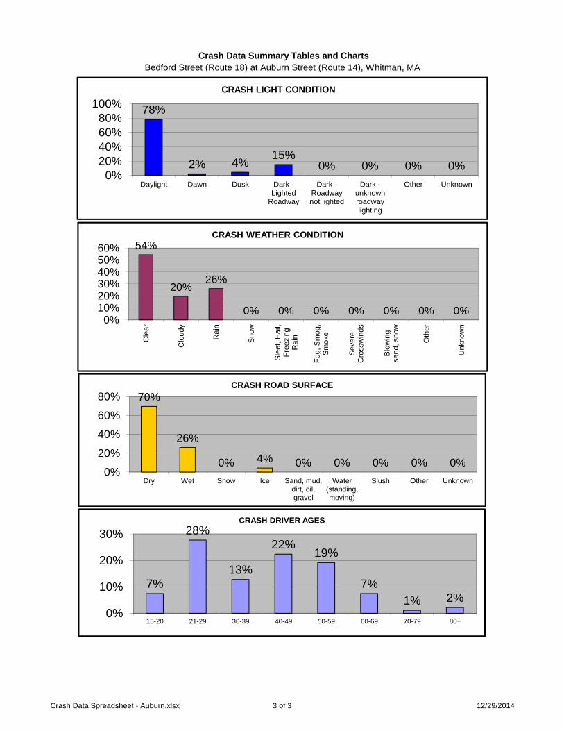
Bedford Street (Route 18) at Auburn Street (Route 14), Whitman, MA Crash Data Summary Tables and Charts
54%
20%26%
0% 0% 0% 0% 0% 0% 0%0%
10%20%30%40%50%60%
Cle
ar
Clo
udy
Rai
n
Snow
Slee
t,H
ail,
Free
zing
Rai
n
Fog,
Smog
,Sm
oke
Seve
reC
ross
win
ds
Blow
ing
sand
,sno
w
Oth
er
Unk
now
n
CRASH WEATHER CONDITION
70%
26%
0% 4% 0% 0% 0% 0% 0%0%
20%
40%
60%
80%
Dry Wet Snow Ice Sand, mud,dirt, oil,gravel
Water(standing,moving)
Slush Other Unknown
CRASH ROAD SURFACE
7%
28%
13%
22%19%
7%1% 2%
0%
10%
20%
30%
15-20 21-29 30-39 40-49 50-59 60-69 70-79 80+
CRASH DRIVER AGES
78%
2% 4% 15%0% 0% 0% 0%
0%20%40%60%80%
100%
Daylight Dawn Dusk Dark -Lighted
Roadway
Dark -Roadwaynot lighted
Dark -unknownroadwaylighting
Other Unknown
CRASH LIGHT CONDITION
Crash Data Spreadsheet - Auburn.xlsx 3 of 3 12/29/2014
SYMBOLS COLLISION TYPESMoving VehicleBacking VehicleNon-Involved Vehicle
Parked VehicleFixed ObjectFatal AccidentInjury Accident
Rear EndHead OnSide SwipeOut of ControlLeft TurnRight Angle
BicyclePedestrian
Intersection: Bedford Street (Route 18) atTemple Street (Route 27)/Warren Avenue
Date Range: January 2011 - December 2013
Group, Inc.L i nco l n , R I - N orwood , MA - Hartford , CT
Engineers Planners Landscape ArchitectsCOLLISION DIAGRAM
CrashDate Crash Day Time of Day Comments
m/d/y Type Type Type Type Type D1 D2 D31 1/10/11 Monday 8:13 PM Angle Dark - lighted roadway Clear Dry Other improper action 36 382 1/11/11 Tuesday 4:49 PM Angle Dusk Clear Dry Failed to yield right of way 19 35 Driver stated his visibility was obstructed3 1/19/11 Wednesday 5:42 PM Angle Dark - lighted roadway Rain Wet Inattention 21 244 1/22/11 Saturday 11:10 AM Single Vehicle Crash Daylight Clear Snow No Improper Driving 47 Sidewalk plow struct traffic signal post, knocking it down5 2/4/11 Friday 5:59 PM Angle Dark - lighted roadway Clear Dry Failed to yield right of way 20 35 Followed vehicle in front too closely and did not see oncoming car6 4/2/11 Saturday 10:25 AM Rear-end Daylight Clear Dry Inattention 56 317 4/18/11 Monday 1:41 PM Rear-end Daylight Clear Dry Followed too closely 45 178 5/1/11 Sunday 8:42 PM Sideswipe, same direction Dark - lighted roadway Clear Dry Failed to yield right of way 44 39 Vehicle was cut off by passing vehicle9 5/4/11 Wednesday 1:05 PM Rear-end Daylight Cloudy Dry Followed too closely 62 25 57
10 5/10/11 Tuesday 2:47 PM Angle Daylight Cloudy Dry Unknown 18 21
11 5/26/11 Thursday 5:22 PM Angle Daylight Clear Dry No Improper Driving 43 22Vehicle was stopped in middle of intersection to take left when light turnedgreen for opposing traffic
12 6/26/11 Sunday 12:17 PM Sideswipe, same direction Daylight Clear DryFailure to keep in proper lane orrunning off road 66 22 44 Vehicle tried to merge between two vehicles, striking both of them
13 7/8/11 Friday 8:44 PM Angle Dark - lighted roadway Rain Wet Inattention 37 1714 8/29/11 Monday 4:09 PM Angle Daylight Clear Dry No Improper Driving 82 18 Signal were not working due to power outage; barrels w/stop signs used15 9/6/11 Tuesday 10:31 AM Angle Daylight Rain Wet Unknown 58 25 Both vehicles stated they had green light16 9/9/11 Friday 1:39 PM Angle Daylight Clear Dry Inattention 37 24 Turning into Cumberland Farms (#727 Bedford Rd)17 9/18/11 Sunday 11:41 AM Angle Daylight Cloudy Dry Unknown 62 4818 9/30/11 Friday 6:51 PM Rear-end Dark - lighted roadway Clear Dry Inattention 48 48 17 Slowed to allow vehicle out of parking lot19 11/14/11 Monday 3:34 PM Rear-end Daylight Clear Dry Followed too closely 49 5320 12/3/11 Saturday 8:02 PM Single Vehicle Crash Dark - lighted roadway Clear Dry No Improper Driving 46 Tractor-Trailer struck traffic signal post, knocking it down
21 12/4/11 Sunday 10:10 AM Angle Daylight Clear Dry
Operating Vehicle in erratic, reckless,careless, negligent, or aggressivemanner 22 73
22 12/19/11 Monday 7:26 PM Head on Dark - lighted roadway Clear Dry Failed to yield right of way 64 2823 12/28/11 Wednesday 1:18 PM Angle Daylight Cloudy Dry Failed to yield right of way 49 43 Vehicle attempting to turn left out of the Johnny Foodmaster parking lot24 1/26/12 Thursday 8:43 AM Single Vehicle Crash Daylight Clear Dry Over-correcting/over-steering 35 Tractor-Trailer struck traffic signal post, knocking it down25 2/17/12 Friday 9:31 AM Angle Daylight Rain Wet Unknown 35 20 Turning out of Cumberland Farms (#727 Bedford Rd) headed northbound26 3/1/12 Thursday 7:29 PM Sideswipe, same direction Dark - lighted roadway Rain Wet Failed to yield right of way 62 20 Vehicle decided to go through intersection intsead of turning right27 5/12/12 Saturday 1:25 PM Angle Daylight Clear Dry Failed to yield right of way 79 20 Vehicle attempting to turn left out of the Johnny Foodmaster parking lot28 6/3/12 Sunday 1:46 PM Angle Daylight Clear Dry Failed to yield right of way 34 41 39 Vehicle traveling at high rate of speed EB and ran red light
29 6/8/12 Friday 3:26 PM Angle Daylight Clear DryDisregarded traffic signs, signals,road markings 22 29 Vehicle traveling EB ran red light
30 6/15/12 Friday 4:51 PM Angle Daylight Clear Dry Failed to yield right of way 17 8431 9/17/12 Monday 2:51 PM Single Vehicle Crash Daylight Clear Dry Unknown 26 Tractor-Trailer struck traffic signal post, knocking it down
32 9/25/12 Tuesday 2:57 PM Angle Daylight Clear Dry
Operating Vehicle in erratic, reckless,careless, negligent, or aggressivemanner 40 51
33 9/28/12 Friday 4:34 PM Angle Daylight Rain Wet Unknown 22 4434 10/2/12 Tuesday 9:02 PM Single Vehicle Crash Dark - lighted roadway Rain Wet No Improper Driving 44 23 Pedestrian ran into drivers side mirror, claims it was his fault35 10/3/12 Wednesday 6:17 PM Angle Dusk Rain Wet Failed to yield right of way 31 46 Turning out of Cumberland Farms (#727 Bedford Rd) headed northbound36 10/11/12 Thursday 2:23 PM Angle Daylight Clear Dry No Improper Driving 48 Thought school bus was turning into parking lot rather than SB on Bedford
37 10/14/12 Sunday 8:41 PM Angle Dark - lighted roadway Clear Dry
Operating Vehicle in erratic, reckless,careless, negligent, or aggressivemanner 34 37 OUI (3rd offense), ran red light and fled the scene into the woods
38 10/23/12 Tuesday 11:20 AM Angle Daylight Clear Dry Failed to yield right of way 57 71 Ran red light39 12/3/12 Monday 8:18 AM Sideswipe, same direction Daylight Clear Dry No Improper Driving 22 Hit and run40 12/30/12 Sunday 7:41 PM Angle Dark - lighted roadway Clear Dry road markings 33 1641 12/31/12 Monday 2:43 PM Angle Daylight Clear Wet Failed to yield right of way 52 3842 2/4/13 Monday 7:56 AM Single Vehicle Crash Dawn Snow Snow Made an improper turn 55 Tractor-Trailer struck traffic signal post, knocking it down
43 2/11/13 Monday 8:37 AM Rear-end Daylight Snow Snow
Swerving or avoiding due to wind,slippery surface, vehicle, object, non-motorist in roadway, etc. 25 43
Vehicle skidded and swerved to avoid collision but could not due to slipperyroad conditions
44 2/19/13 Tuesday 5:38 AM Single Vehicle Crash Dark - lighted roadway Clear Dry road markings 19 Lost control of vehicle and hit snow bank45 2/24/13 Sunday 6:59 PM Angle Dark - lighted roadway Snow Wet Failed to yield right of way 18 4046 3/8/13 Friday 1:35 PM Angle Daylight Snow Snow Inattention 36 58 Could not see the signals due to weather conditions and ran red light47 4/5/13 Friday 9:57 PM Sideswipe, same direction Dusk Clear Dry Inattention 45 52 Attempted to change lanes, but did not see wehcile in blind spot
Road Surface Driver Contributing Code Ages
Crash Data Summary Table
Manner of Collision Light ConditionWeather
Condition
January 2011 - December 2013 Crash
DiagramRef #
Bedford Street (Route 18) at Temple Street (Route 27)/Warren Avenue, Whitman, MA
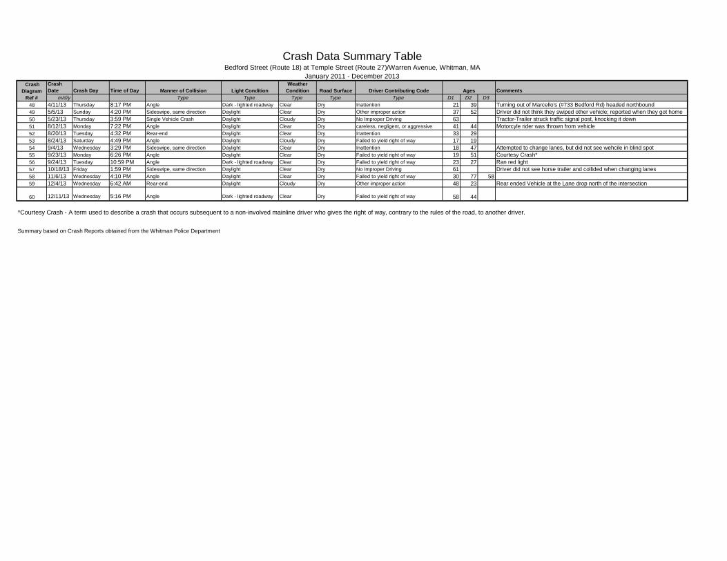
CrashDate Crash Day Time of Day Comments
m/d/y Type Type Type Type Type D1 D2 D3Road Surface Driver Contributing Code Ages
Crash Data Summary Table
Manner of Collision Light ConditionWeather
Condition
January 2011 - December 2013 Crash
DiagramRef #
Bedford Street (Route 18) at Temple Street (Route 27)/Warren Avenue, Whitman, MA
48 4/11/13 Thursday 8:17 PM Angle Dark - lighted roadway Clear Dry Inattention 21 39 Turning out of Marcello's (#733 Bedford Rd) headed northbound49 5/5/13 Sunday 4:20 PM Sideswipe, same direction Daylight Clear Dry Other improper action 37 52 Driver did not think they swiped other vehicle; reported when they got home50 5/23/13 Thursday 3:59 PM Single Vehicle Crash Daylight Cloudy Dry No Improper Driving 63 Tractor-Trailer struck traffic signal post, knocking it down51 8/12/13 Monday 7:22 PM Angle Daylight Clear Dry careless, negligent, or aggressive 41 44 Motorcyle rider was thrown from vehicle52 8/20/13 Tuesday 4:32 PM Rear-end Daylight Clear Dry Inattention 33 2953 8/24/13 Saturday 4:49 PM Angle Daylight Cloudy Dry Failed to yield right of way 17 1954 9/4/13 Wednesday 3:29 PM Sideswipe, same direction Daylight Clear Dry Inattention 18 47 Attempted to change lanes, but did not see wehcile in blind spot55 9/23/13 Monday 6:26 PM Angle Daylight Clear Dry Failed to yield right of way 19 51 Courtesy Crash*56 9/24/13 Tuesday 10:59 PM Angle Dark - lighted roadway Clear Dry Failed to yield right of way 23 27 Ran red light57 10/18/13 Friday 1:59 PM Sideswipe, same direction Daylight Clear Dry No Improper Driving 61 Driver did not see horse trailer and collided when changing lanes58 11/6/13 Wednesday 4:10 PM Angle Daylight Clear Dry Failed to yield right of way 30 77 5859 12/4/13 Wednesday 6:42 AM Rear-end Daylight Cloudy Dry Other improper action 48 23 Rear ended Vehicle at the Lane drop north of the intersection
60 12/11/13 Wednesday 5:16 PM Angle Dark - lighted roadway Clear Dry Failed to yield right of way 58 44
*Courtesy Crash - A term used to describe a crash that occurs subsequent to a non-involved mainline driver who gives the right of way, contrary to the rules of the road, to another driver.
Summary based on Crash Reports obtained from the Whitman Police Department
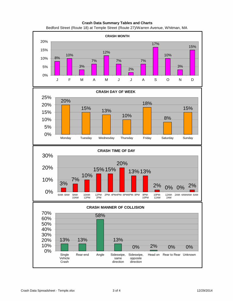
Bedford Street (Route 18) at Temple Street (Route 27)/Warren Avenue, Whitman, MA Crash Data Summary Tables and Charts
20%15% 13%
10%
18%
8%
15%
0%5%
10%15%20%25%
Monday Tuesday Wednesday Thursday Friday Saturday Sunday
CRASH DAY OF WEEK
3%7%
10%15%15%
20%13%13%
2% 0% 0% 2%0%
10%
20%
30%
6AM- 8AM 8AM-10AM
10AM-12PM
12PM-2PM
2PM- 4PM4PM- 6PM6PM- 8PM 8PM-10PM
10PM-12AM
12AM-2AM
2AM- 4AM4AM- 6AM
CRASH TIME OF DAY
13% 13%
58%
13%0% 2% 0% 0%
0%10%20%30%40%50%60%70%
SingleVehicleCrash
Rear-end Angle Sideswipe,same
direction
Sideswipe,oppositedirection
Head on Rear to Rear Unknown
CRASH MANNER OF COLLISION
8%10%
3%7%
12%
7%
2%
7%
17%
10%
3%
15%
0%
5%
10%
15%
20%
J F M A M J J A S O N D
CRASH MONTH
Crash Data Spreadsheet - Temple.xlsx 3 of 4 12/29/2014
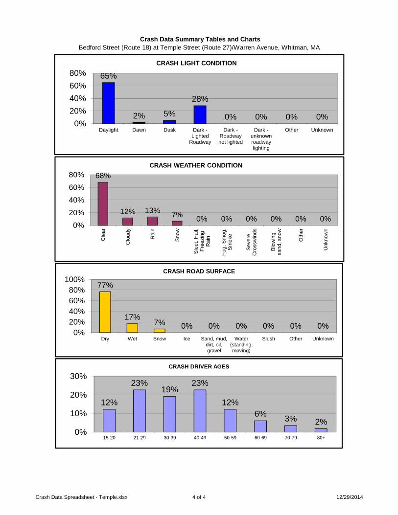
Bedford Street (Route 18) at Temple Street (Route 27)/Warren Avenue, Whitman, MA Crash Data Summary Tables and Charts
68%
12% 13% 7% 0% 0% 0% 0% 0% 0%0%
20%40%60%80%
Cle
ar
Clo
udy
Rai
n
Snow
Slee
t,H
ail,
Free
zing
Rai
n
Fog,
Smog
,Sm
oke
Seve
reC
ross
win
ds
Blow
ing
sand
,sno
w
Oth
er
Unk
now
n
CRASH WEATHER CONDITION
77%
17%7% 0% 0% 0% 0% 0% 0%
0%20%40%60%80%
100%
Dry Wet Snow Ice Sand, mud,dirt, oil,gravel
Water(standing,moving)
Slush Other Unknown
CRASH ROAD SURFACE
12%
23%19%
23%
12%6% 3% 2%
0%
10%
20%
30%
15-20 21-29 30-39 40-49 50-59 60-69 70-79 80+
CRASH DRIVER AGES
65%
2% 5%
28%
0% 0% 0% 0%0%
20%40%60%80%
Daylight Dawn Dusk Dark -Lighted
Roadway
Dark -Roadwaynot lighted
Dark -unknownroadwaylighting
Other Unknown
CRASH LIGHT CONDITION
Crash Data Spreadsheet - Temple.xlsx 4 of 4 12/29/2014