ROAD CONSTRUCTION PROJECTS: AN INTEGRATED … · planners carry out earthwork operations in road...
9
Proceedings of the 13th International Conference on Construction Applications of Virtual Reality, 30-31 October 2013, London, UK ROAD CONSTRUCTION PROJECTS: AN INTEGRATED AND INTERACTIVE VISUAL TOOL FOR PLANNING EARTHWORK OPERATIONS 1 Mohamad Kassem, Rajiv Chavada & Nashwan Dawood Teesside University, UK Claudio Benghi Northumbria University, UK Romeu Sanches Mota-Engil, Portugal ABSTRACT: Road construction projects are expensive and highly affected by uncertainties related to factors such as weather, type of soil and other site and environmental factors. These uncertainties impact on the accuracy of predicting resource productivity and developing reliable schedules for earthwork operations. Current simulation and planning approaches and tools not only lack the capabilities of dealing with such uncertainties but they also lack the integration and intelligence to simulate multiple strategies – a model should be built every time a new scenario is required. As a result, planning decisions regarding the assignment of resources are purely based on planners experience and project plans are not the outcomes of comparing various allocation strategies. This paper proposed an approach which is visual, interactive, and integrator of the functions involved in earthwork operation such as activity scheduling, resource productivity calculation, optimal distance calculation and profile visualization. This specifically addresses the challenges related to the limited intelligence and capability of simulating multiple strategies of resource allocation in earthwork operation. The proposed development builds upon a prior study (Castro and Dawood, 2005) that developed a knowledge-driven approach to tackle the ‘uncertainty’ challenge affecting the productivity of resources. This paper hypothesizes that an integrated approach which integrates the various functions involved in earthwork operations and provides an interactive environment where planners could easily change planning decisions and promptly analyze the effect of their decisions could improve the reliability of plans and consequently improve the performance of road construction projects. KEYWORDS: Earthwork operations, interactivity, resource planning, visualisation. 1. INTRODUCTION Road construction projects are inherently unpredictable and complex due to the dynamic nature of site operations and uncertainties related to weather, soil characteristic and site conditions. Current practices suggest that project planners carry out earthwork operations in road construction using deterministic methods based on their past experience and knowledge. As a result, cost and time overruns are often caused by the lack of inclusion and appreciation of risk factors. Although information technology (IT) systems can demonstrate uncertain and stochastic behaviour of different processes to predict the outcomes of construction projects, IT systems utilised in earthwork operation still lack such capabilities. There have been several studies addressing the above challenges. Jayawardane and Price (1994) developed RESOM (Roadwork Earthwork moving Simulation Optimisation Model) to optimise earthwork operations applying linear/integer programming techniques. Askew et al. (2002) used mass haul diagram (MHD) techniques for earthwork allocation between cutting and filling sections. MHS is graphical representation of the volume of cutting and filling sections in relation to their position on the site, and are widely used for linear construction like road and railways (Warren, 1996, p85). Liapi (2003) a collaborative decision-making construction scheduling and planning for highway construction projects in which visualisation is utilised to validate the construction 1 Citation: Kassem, M., Chavada, R., Dawood, N., Benghi, C. & Sanches, R. (2013). Road construction projects: an integrated and interactive visual tool for planning earthwork operations. In: N. Dawood and M. Kassem (Eds.), Proceedings of the 13th International Conference on Construction Applications of Virtual Reality, 30-31 October 2013, London, UK. 584
Transcript of ROAD CONSTRUCTION PROJECTS: AN INTEGRATED … · planners carry out earthwork operations in road...
Proceedings of the 13th International Conference on Construction Applications of Virtual Reality, 30-31 October 2013, London, UK
ROAD CONSTRUCTION PROJECTS: AN INTEGRATED AND INTERACTIVE VISUAL TOOL FOR PLANNING EARTHWORK OPERATIONS1
Mohamad Kassem, Rajiv Chavada & Nashwan Dawood Teesside University, UK
Claudio Benghi Northumbria University, UK
Romeu Sanches Mota-Engil, Portugal
ABSTRACT: Road construction projects are expensive and highly affected by uncertainties related to factors such as weather, type of soil and other site and environmental factors. These uncertainties impact on the accuracy of predicting resource productivity and developing reliable schedules for earthwork operations. Current simulation and planning approaches and tools not only lack the capabilities of dealing with such uncertainties but they also lack the integration and intelligence to simulate multiple strategies – a model should be built every time a new scenario is required. As a result, planning decisions regarding the assignment of resources are purely based on planners experience and project plans are not the outcomes of comparing various allocation strategies.
This paper proposed an approach which is visual, interactive, and integrator of the functions involved in earthwork operation such as activity scheduling, resource productivity calculation, optimal distance calculation and profile visualization. This specifically addresses the challenges related to the limited intelligence and capability of simulating multiple strategies of resource allocation in earthwork operation. The proposed development builds upon a prior study (Castro and Dawood, 2005) that developed a knowledge-driven approach to tackle the ‘uncertainty’ challenge affecting the productivity of resources. This paper hypothesizes that an integrated approach which integrates the various functions involved in earthwork operations and provides an interactive environment where planners could easily change planning decisions and promptly analyze the effect of their decisions could improve the reliability of plans and consequently improve the performance of road construction projects.
KEYWORDS: Earthwork operations, interactivity, resource planning, visualisation.
1. INTRODUCTION
Road construction projects are inherently unpredictable and complex due to the dynamic nature of site operations and uncertainties related to weather, soil characteristic and site conditions. Current practices suggest that project planners carry out earthwork operations in road construction using deterministic methods based on their past experience and knowledge. As a result, cost and time overruns are often caused by the lack of inclusion and appreciation of risk factors. Although information technology (IT) systems can demonstrate uncertain and stochastic behaviour of different processes to predict the outcomes of construction projects, IT systems utilised in earthwork operation still lack such capabilities.
There have been several studies addressing the above challenges. Jayawardane and Price (1994) developed RESOM (Roadwork Earthwork moving Simulation Optimisation Model) to optimise earthwork operations applying linear/integer programming techniques. Askew et al. (2002) used mass haul diagram (MHD) techniques for earthwork allocation between cutting and filling sections. MHS is graphical representation of the volume of cutting and filling sections in relation to their position on the site, and are widely used for linear construction like road and railways (Warren, 1996, p85). Liapi (2003) a collaborative decision-making construction scheduling and planning for highway construction projects in which visualisation is utilised to validate the construction
1 Citation: Kassem, M., Chavada, R., Dawood, N., Benghi, C. & Sanches, R. (2013). Road construction projects: an integrated and interactive visual tool for planning earthwork operations. In: N. Dawood and M. Kassem (Eds.), Proceedings of the 13th International Conference on Construction Applications of Virtual Reality, 30-31 October 2013, London, UK.
584
Proceedings of the 13th International Conference on Construction Applications of Virtual Reality, 30-31 October 2013, London, UK
process. Kemppainen et al. (2004) developed a system dubbed “Dyanroad2”, which is a mass haul and schedule planning and control software, to support planners optimising the cost of resources, mass hauls and schedules. Dyanroad2 encapsulated linear and genetic algorithms for its optimization functions. Kang et al. (2006) used morphing (visual) techniques to simulate earthwork operations such as cutting and filling where progress of site activities are simulated and changes of ground levels due to cut and fill are visualised. Chi-Ming et. al. (2007) developed an integrated system that combines a path-finding algorithm: ripple ring, plant database and genetic algorithms for optimising the feasible alternatives. Kenley and Seppanen (2009) developed activity and located based scheduling methodologies for managing the construction sites. Shah and Dawood (2011) developed a model that produces weekly location plans presented in the form of time-chainage. The time-chainage diagram is also known as Linear Scheduling Method (LSM)/Time-location charts, and it is widely used in those linear construction projects that have a repetitive nature of work activities (Kenley, 2004).
There are some commercially available tools for earthwork planning. The main two tools are TILOS2 and DynaRoad3. TILOS is a time-location planning tool for managing linear construction projects such as roads, rail lines, pipelines and tunnels. DynaRoad4 is a tool that can be used for schedule, mass haulage optimisation and progress control of earthwork operations in construction projects such as roads and railways. However both tools lack the capabilities of simulating the productivity and cost while considering factors and variables such as sets of equipment, site constraints and soil characteristics and enabling “what if scenarios”.
The development proposed in this paper is a continuation of a previous research effort by Dawood and Castro (2009). They have developed a knowledge-based simulator dubbed RoadSIM to assist planners select resources and develop reliable project plan. Also with this approach, implementing what-if analysis is not possible due to the lack of integration between the functions of earthwork operations and the lack of interactivity. The approach proposed in this study is to integrate the knowledge driven resource module (i.e. RoadSIM) with the other earthwork functions including project planning and scheduling, optimal distance calculation and profile generation in an interactive visual tool. It is hypothesised that such integration augmented with visualization and interactivity could lead to increase the reliability of construction plans. To achieve the proposed approach, the paper addresses the below three objectives:
• Develop a conceptual approach that identifies and integrates the different earthwork components including resource module, activity planning module, distance optimisation and earthwork profile visualisation.
• Implement the different earthwork modules into an integrated, visual and interactive environment using object oriented methodology.
• Verify the system developed with empirical industrial data.
2. THE CONCEPTUAL APPROACH
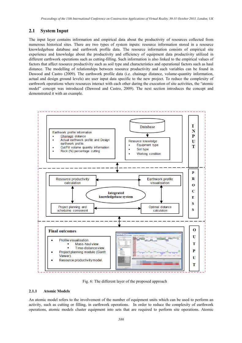
The conceptual approach for integrating the different functions of earthwork operations and enabling a visual interactive planning is depicted in Figure 1. It includes the data input layer, the process layer and the outcome layers. The approach integrates: the resource module, profile visualisation, optimal distance calculation and activity planning and scheduling in an interactive, visual and inter-dependent manner. Information can be exchanged systematically between the different functions. Using such a approach, project planners can avoid the execution and assignment of under-allocated or over-allocated resources and therefore, improve the productivity at operational phase. Earthwork operations have predefined resources and their duration is calculated through productivity rates. The system demonstrates an interactive profile viewer for “Mass-haul” and “Time-distance” profiles, resource model for productivities calculation, Gantt viewer for activity planning and management. As a result of such inter-dependent integration, what-if scenarios can be immediately performed. Each of the system layers is described below.
2 TILOS (2013), Available at: [http://www.tilos.org]
3 TILOS (2013), Available at: [http://www.tilos.org] 4 DynaRoad (2010), Available at: [http://www.dynaroad.com]
585
Proceedings of the 13th International Conference on Construction Applications of Virtual Reality, 30-31 October 2013, London, UK
2.1 System Input
The input layer contains information and empirical data about the productivity of resources collected from numerous historical sites. There are two types of system inputs: resource information stored in a resource knowledgebase database and earthwork profile data. The resource information consists of empirical site experience and knowledge about the productivity and efficiency of equipment data productivity utilized in different earthwork operations such as cutting-filling. Such information is also linked to the empirical values of factors that affect resource productivity such as soil type and characteristics and operational factors such as haul distance. The modelling of relationships between resource productivity and such variables can be found in Dawood and Castro (2009). The earthwork profile data (i.e. chainage distance, volume-quantity information, actual and design ground levels) are user input data specific to the new project. To reduce the complexity of earthwork operations where resources interact with each other during the execution of site activities, the “atomic model” concept was introduced (Dawood and Castro, 2009). The next section introduces the concept and demonstrated it with an example.
Fig. 6: The different layer of the proposed approach
2.1.1 Atomic Models
An atomic model refers to the involvement of the number of equipment units which can be used to perform an activity, such as cutting or filling, in earthwork operations. In order to reduce the complexity of earthwork operations, atomic models cluster equipment into sets that are required to perform site operations. Atomic
586
Proceedings of the 13th International Conference on Construction Applications of Virtual Reality, 30-31 October 2013, London, UK
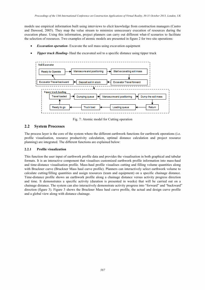
models use empirical information built using interviews to elicit knowledge from construction managers (Castro and Dawood, 2005). They map the value stream to minimize unnecessary execution of resources during the execution phase. Using this information, project planners can carry out different what-if scenarios to facilitate the selection of resources. Two examples of atomic models are presented in figure 2 for two site operations:
• Excavation operation- Excavate the soil mass using excavation equipment
• Tipper truck Hauling- Haul the excavated soil to a specific distance using tipper truck
Fig. 7: Atomic model for Cutting operation
2.2 System Processes
The process layer is the core of the system where the different earthwork functions for earthwork operations (i.e. profile visualisation, resource productivity calculation, optimal distance calculation and project resource planning) are integrated. The different functions are explained below:
2.2.1 Profile visualization
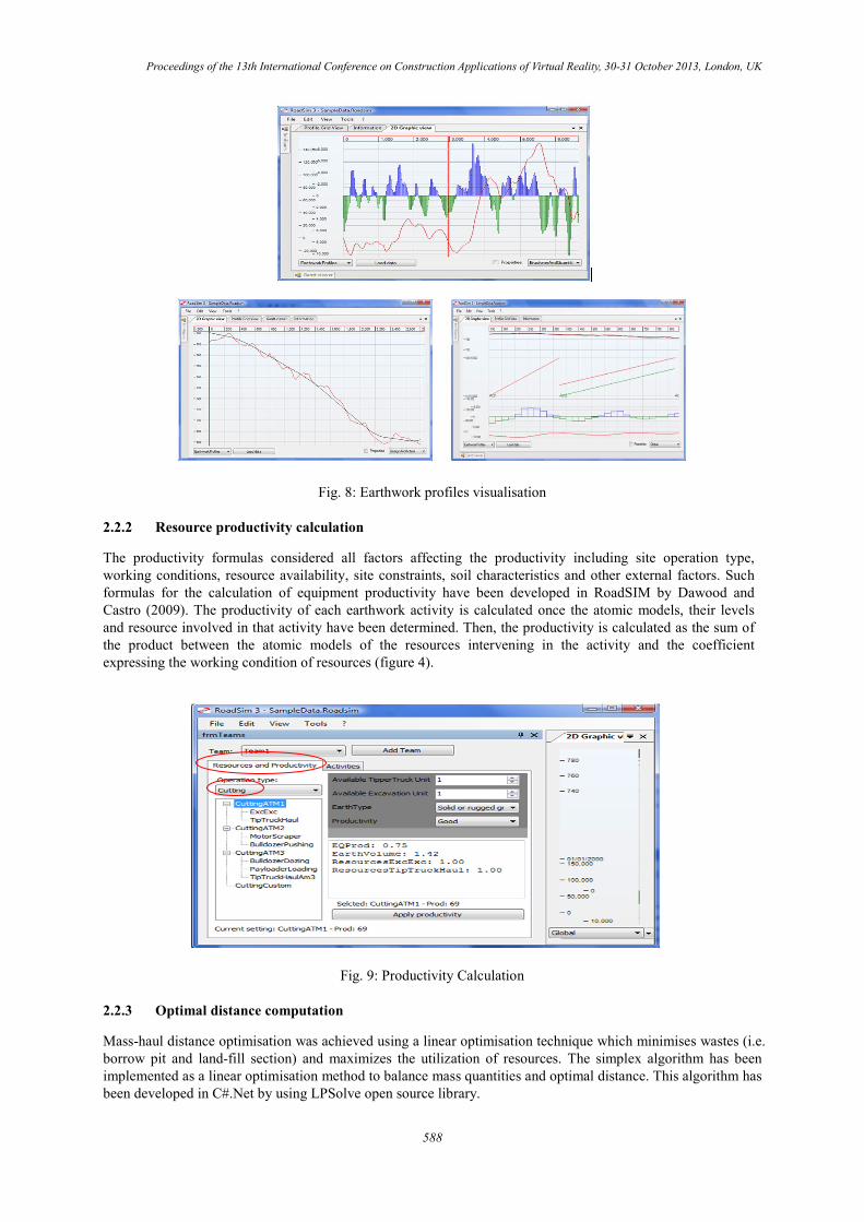
This function the user input of earthwork profile data and provides the visualisation in both graphical and tabular formats. It is an interactive component that visualises customized earthwork profile information into mass-haul and time-distance visualisation profile. Mass-haul profile visualises cutting and filling volume quantities along with Bruckner curve (Bruckner Mass haul curve profile). Planners can interactively select earthwork volume to calculate cutting/filling quantities and assign resources (team and equipment) on a specific chainage distance. Time-distance profile shows an earthwork profile along a chainage distance versus activity progress direction and time. It demonstrates a specific activity (duration is presented in weeks) that will be carried out on a chainage distance. The system can also interactively demonstrate activity progress into “forward” and “backward” direction (figure 3). Figure 3 shows the Bruckner Mass haul curve profile, the actual and design curve profile and a global view along with distance chainage.
587
Proceedings of the 13th International Conference on Construction Applications of Virtual Reality, 30-31 October 2013, London, UK
Fig. 8: Earthwork profiles visualisation
2.2.2 Resource productivity calculation
The productivity formulas considered all factors affecting the productivity including site operation type, working conditions, resource availability, site constraints, soil characteristics and other external factors. Such formulas for the calculation of equipment productivity have been developed in RoadSIM by Dawood and Castro (2009). The productivity of each earthwork activity is calculated once the atomic models, their levels and resource involved in that activity have been determined. Then, the productivity is calculated as the sum of the product between the atomic models of the resources intervening in the activity and the coefficient expressing the working condition of resources (figure 4).
Fig. 9: Productivity Calculation
2.2.3 Optimal distance computation
Mass-haul distance optimisation was achieved using a linear optimisation technique which minimises wastes (i.e. borrow pit and land-fill section) and maximizes the utilization of resources. The simplex algorithm has been implemented as a linear optimisation method to balance mass quantities and optimal distance. This algorithm has been developed in C#.Net by using LPSolve open source library.
588
Proceedings of the 13th International Conference on Construction Applications of Virtual Reality, 30-31 October 2013, London, UK
2.2.4 Project planning and scheduling
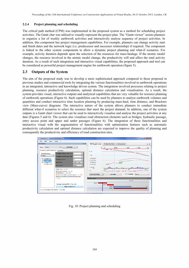
The critical path method (CPM) was implemented in the proposed system as a method for scheduling project activities. The Gantt char was utilised to visually represent the project plan. The “Gantt-viewer” assists planners to organize a list of weekly earthwork activities and interactively analyse sequence of project activities. In addition, this component has project management capabilities. For example, planners can change activity start and finish dates and the network logic (i.e. predecessor and successor relationship) if required. The component is linked to the other system components to allow a dynamic project planning and what-if scenarios. For example, activity duration depends upon the selection of the resources for mass-haulage. If the atomic model changes, the resource involved in the atomic model change, the productivity will and affect the total activity duration. As a result of such integration and interactive visual capabilities, the proposed approach and tool can be considered as powerful project management engine for earthwork operation (figure 5).
2.3 Outputs of the System
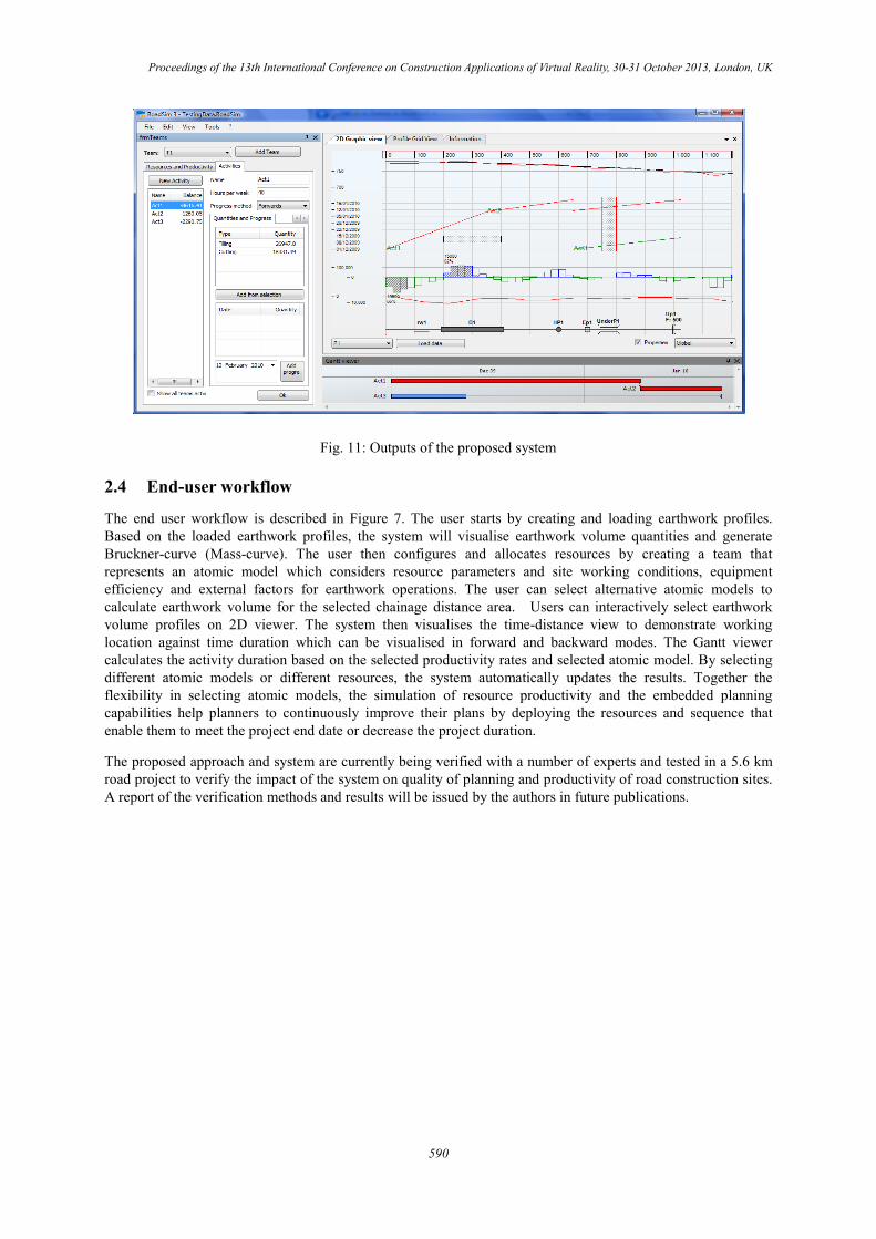
The aim of the proposed study was to develop a more sophisticated approach compared to those proposed in previous studies and commercial tools by integrating the various functionalities involved in earthwork operations in an integrated, interactive and knowledge driven system. The integration involved processes relating to project planning, resource productivity calculation, optimal distance calculation and visualisation. As a result, the system provides visual, interactive outputs and analytical capabilities that are very valuable for resource planning of earthwork operations (Figure 6). Such capabilities can be used by planners to analyse earthwork volumes and quantities and conduct interactive time location planning by producing mass-haul, time distance, and Bruckner view (Mass-curve) diagrams. The interactive nature of the system allows planners to conduct immediate different what-if scenarios to select the resource that meet the project demand. In addition, one of the system outputs is a Gantt chart viewer that can be used to interactively visualise and analyse the project activities at any date (Figures 5 and 6). The system also visualises road obstruction elements such as bridges, hydraulic passage, entry access point and upper and under passages (Figure 6). The integration of these functionalities and interactive visual with the augmentation of functionalities with optimisation features such as automatic productivity calculation and optimal distance calculation are expected to improve the quality of planning and consequently the productivity and efficiency of road construction sites.
Fig. 10: Project planning and scheduling
589
Proceedings of the 13th International Conference on Construction Applications of Virtual Reality, 30-31 October 2013, London, UK
Fig. 11: Outputs of the proposed system
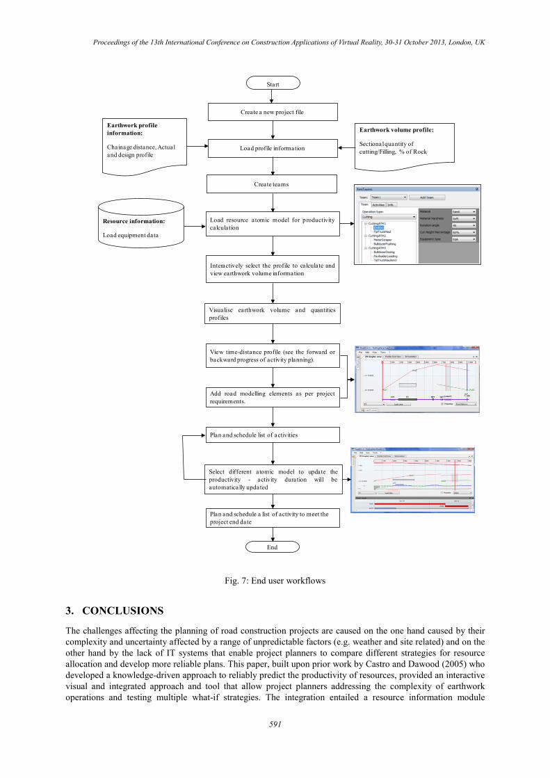
2.4 End-user workflow
The end user workflow is described in Figure 7. The user starts by creating and loading earthwork profiles. Based on the loaded earthwork profiles, the system will visualise earthwork volume quantities and generate Bruckner-curve (Mass-curve). The user then configures and allocates resources by creating a team that represents an atomic model which considers resource parameters and site working conditions, equipment efficiency and external factors for earthwork operations. The user can select alternative atomic models to calculate earthwork volume for the selected chainage distance area. Users can interactively select earthwork volume profiles on 2D viewer. The system then visualises the time-distance view to demonstrate working location against time duration which can be visualised in forward and backward modes. The Gantt viewer calculates the activity duration based on the selected productivity rates and selected atomic model. By selecting different atomic models or different resources, the system automatically updates the results. Together the flexibility in selecting atomic models, the simulation of resource productivity and the embedded planning capabilities help planners to continuously improve their plans by deploying the resources and sequence that enable them to meet the project end date or decrease the project duration.
The proposed approach and system are currently being verified with a number of experts and tested in a 5.6 km road project to verify the impact of the system on quality of planning and productivity of road construction sites. A report of the verification methods and results will be issued by the authors in future publications.
590
Proceedings of the 13th International Conference on Construction Applications of Virtual Reality, 30-31 October 2013, London, UK
Fig. 7: End user workflows
3. CONCLUSIONS
The challenges affecting the planning of road construction projects are caused on the one hand caused by their complexity and uncertainty affected by a range of unpredictable factors (e.g. weather and site related) and on the other hand by the lack of IT systems that enable project planners to compare different strategies for resource allocation and develop more reliable plans. This paper, built upon prior work by Castro and Dawood (2005) who developed a knowledge-driven approach to reliably predict the productivity of resources, provided an interactive visual and integrated approach and tool that allow project planners addressing the complexity of earthwork operations and testing multiple what-if strategies. The integration entailed a resource information module
Start
End
Create a new project file
Load profile information
Load resource atomic model for productivitycalculation
Earthwork profile information:
Chainage distance, Actual and design profile
Earthwork volume profile:
Sectional quantity of cutting/Filling, % of Rock
Resource information:
Load equipment data
Interactively select the profile to calculate andview earthwork volume information
Visualise earthwork volume and quantitiesprofiles
Add road modelling elements as per projectrequirements.
View time-distance profile (see the forward orbackward progress of activity planning).
Plan and schedule list of activities
Select different atomic model to update theproductivity - activity duration will beautomatically updated
Plan and schedule a list of activity to meet the project end date
Create teams
591
Proceedings of the 13th International Conference on Construction Applications of Virtual Reality, 30-31 October 2013, London, UK
(atomic model, resource productivity calculation, team allocation), the optimal distance calculation, the project planning and earthwork visualisation components (actual and design graph, chainage distance, mass-haul and time-distance view, Bruckner curve, road obstruction). The user interface with all these modules is interactive and planners can make changes to the resource module and schedule and immediately analyse the effect of the changes. The hypothesis made was that such an integration and interactivity would lead to reliable plans and consequently increase the productivity at the operational stage. The impact of the proposed approach and tool on the accuracy of planning of earthwork operation is being investigated with a number of road construction planning experts and in a 5.7 km road projects and results will be published in the near future.
4. REFERENCES
Askew, W.H., Al-Jibouri, S.H., Mawdesley, M.J. and Patterson, D.E. (2002). Planning linear construction projects: automated method for the generation of earthwork activities, Automation in Construction, Vol. 11, 643-653.
Castro, S. and Dawood, N. (2005). Roadsim: Simulation modelling applied to road construction, International conference on Computing in Civil Engineering, Cancun, Mexico.
Chi Ming, T., Thomas, K. L. and Bill, W. L. (2007). An integrated system for earthmoving planning, construction management and economics, Vol. 25 (11), 1127-1137.
Dawood, N. and Castro, S. (2009) . Automating road construction planning with a specific-domain simulation system, Journal of Information Technology in Construction, Vol. 14, 556-573.
Jayawardane, A. and Price A. (1994). A new approach for optimising earthmoving operations, Proceedings of Institute of Civil Engineering, Transport Journal, 105, Nov. 1994.
Kang, L.S., Jee, S.B., Kim, C.H., Pak, S.Y., and Moon, H.S. (2006). 4D System for visualisation Scheduling Progress of Horizontal Construction Project Including Earth Work, Proceedings of the CONVR Conference 2006, 4-6 August, Florida, USA.
Kemppainen, J., Mäkinen, J., Seppänen, O. and Kankainen, J. (2004). Lean Construction Principles in Infrastructure Construction , Available at: http://www.iglc2004.dk/_root/media/13058_039-kemppainen-makinen-seppanen-kankainen-final.pdf, [last accessed July 2013]
Kenley, R. (2004). Project micromanagement: practical site planning and management of work flow, Proceedings of the 12th International Conference of Lean Construction (IGC12), Helsingor, Denmark, pp 194-205.
Kenley, R. and Seppanen, O. (2009). Location based management of construction projects: part of a new typology for project scheduling methodologies, Proceedings of the 2009 Winter Simulation Conference, Austin, TX, 13–16 December, pp. 2563–70.
Liapi, A. K. (2003). 4D Visualisation of Highway Construction Projects, Proceedings of the 7th International Conference on Information Visualisation (IV’03), 1093-9547/03.
Shah, R.K. and Dawood, N.N. (2011). An innovative approach for generation of a time location plan in road construction projects, Construction Management and Economics, Vol. 29, issue 5.
Warren, D. R. (1996). Civil engineering construction: design and management, Macmillan Press Ltd: London.
592