Riverfront Park Feasibility Study - Wrightsville · Chapter 1 – Background Information Chapter 1...
109
Transcript of Riverfront Park Feasibility Study - Wrightsville · Chapter 1 – Background Information Chapter 1...


Riverfront Park Feasibility Study
Prepared for:
Wrightsville Borough, York County, Pennsylvania
Study Committee Lori Harmer, Wrightsville Municipal Authority Secretary Janelle Hobbs, Wrightsville Borough Council John Klinedinst, Wrightsville Borough Engineer Mark Lentz, Resident Greg Scritchfield, Wrightsville Borough Council Ed Sipes, Wrightsville Borough Council Ann Walko, York County Planning Commission Teresa Weaver, Eastern School District Melissa Wirls, Wrightsville Borough Secretary
Consultants Yost Strodoski Mears, York, PA Recreation and Parks Solutions, Lancaster PA
This Project was financed in part by a grant from the Community Conservation Park Partnership Program, Keystone Recreation, Park and Conservation
Fund, under the administration of the Pennsylvania Department of Conservation and Natural Resources, Bureau of Recreation and Conservation.
December 2011

Riverfront Park Feasibility Study Table of Contents - ii
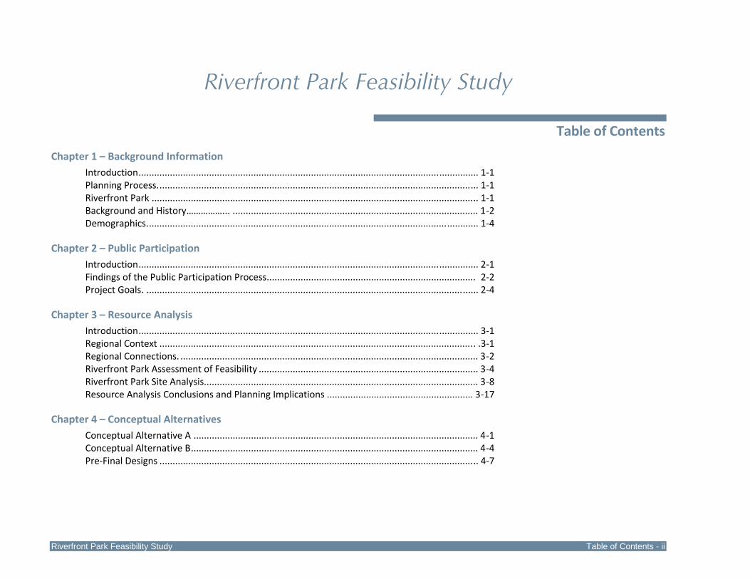
Riverfront Park Feasibility Study
Table of Contents
Chapter 1 – Background Information Introduction.................................................................................................................................. 1‐1 Planning Process........................................................................................................................... 1‐1 Riverfront Park ............................................................................................................................. 1‐1 Background and History……………... .............................................................................................. 1‐2 Demographics............................................................................................................................... 1‐4 Chapter 2 – Public Participation Introduction.................................................................................................................................. 2‐1 Findings of the Public Participation Process................................................................................ 2‐2 Project Goals. ............................................................................................................................... 2‐4 Chapter 3 – Resource Analysis
Introduction.................................................................................................................................. 3‐1 Regional Context ......................................................................................................................... .3‐1 Regional Connections. .................................................................................................................. 3‐2 Riverfront Park Assessment of Feasibility .................................................................................... 3‐4 Riverfront Park Site Analysis......................................................................................................... 3‐8 Resource Analysis Conclusions and Planning Implications ........................................................ 3‐17
Chapter 4 – Conceptual Alternatives
Conceptual Alternative A ............................................................................................................. 4‐1 Conceptual Alternative B.............................................................................................................. 4‐4 Pre‐Final Designs .......................................................................................................................... 4‐7
Table of Contents - iii Riverfront Park Feasibility Study
Chapter 5 – Park Master Plan Introduction.................................................................................................................................. 5‐1 Recreation Opportunities............................................................................................................. 5‐1 Riverfront Park Master Plan ......................................................................................................... 5‐1 General Park Design Considerations ............................................................................................ 5‐8 Sustainability and Green Design Considerations........................................................................ 5‐15
Chapter 6 – Cost & Implementation Analysis
Park Improvement Phasing .......................................................................................................... 6‐1 Early Implementation Projects .................................................................................................... 6‐2 Probable Construction Cost Opinions ......................................................................................... 6‐2 Implementation Tasks .................................................................................................................. 6‐3
Chapter 7 –Operations & Financing
Riverfront Park Operations and Budget ....................................................................................... 7‐1 Administration.............................................................................................................................. 7‐1 Recreation Activities..................................................................................................................... 7‐1 Maintenance ................................................................................................................................ 7‐2 Recommended Minimum Level of Maintenance......................................................................... 7‐3 Maintenance Tasks....................................................................................................................... 7‐6 Potential Partners....................................................................................................................... 7‐11 Operational Revenues and Expenses ......................................................................................... 7‐12 Implementation Strategies for Funding the Development of Riverfront Park .......................... 7‐14
Appendix A – Demographic Profile
List of Maps
Riverfront Park – Site Analysis ...................................................................................................................3‐20 Riverfront Park – Conceptual Alternative A .................................................................................................4‐3 Riverfront Park – Conceptual Alternative B .................................................................................................4‐5 Riverfront Park – Pre‐Final Plan ...................................................................................................................4‐8 Riverfront Park – Master Plan ....................................................................................................................5‐18 Riverfront Park – Master Plan Perspective ................................................................................................5‐19 Riverfront Park – Phasing Plan .....................................................................................................................6‐5
Chapter 1 Background Information


Chapter 1 – Background Information
Riverfront Park Feasibility Study Chapter 1 ‐ 1
Introduction
This project explored the feasibility of enhancing and updating Riverfront Park in Wrightsville Borough, York County, Pennsylvania. Riverfront Park is owned by the Safe Harbor Water Power Corporation and leased to Wrightsville Borough for public use. While the park has provided a riverfront site for public recreation for many years, this project explored the potential of enhancing the park to meet the current and future recreation needs of Borough residents as well as visitors to the municipality and region. A component of the feasibility study was the development of a master plan for Riverfront Park which illustrates enhancements and improvements to achieve the goals identified as part of the feasibility assessment and planning process.
Planning Process
The Riverfront Park Feasibility Study planning process included four parts:
1. Inventory and Assessment of Feasibility
2. Public Participation
3. Park Master Plan
4. Strategic Operations, Budget and Financing Assessment
1. Inventory and Assessment
The natural resources and existing features of Riverfront Park were viewed and assessed throughout the four seasons. Natural resources and manmade facilities were evaluated, visitor use patterns were observed, and site opportunities and constraints were explored. The municipal and regional setting was investigated to consider surrounding land uses, potential and existing linkages, and influences on the park site.
Ownership and opportunities for park development were explored. This assessment defined the feasibility of undertaking future improvements.
2. Public Participation
Citizen input was sought throughout the planning process to inform the assessment of feasibility and guide the development of a relevant master plan for Riverfront Park that reflected the desires and recreation needs of the community. Public input was gathered by working with a study committee, completing interviews with stakeholders, holding a river stakeholders forum, and conducting public meetings.
3. Park Master Plan
Conceptual alternative designs were developed to illustrate different approaches to rehabilitating and developing Riverfront Park to achieve the goals of the community. The study committee reviewed the conceptual alternatives and provided direction for the preparation of the pre‐final design. The master plan for Riverfront Park was finalized based on the outcomes and conclusions of the planning process. Probable construction cost opinions and a phasing plan for implementing the master plan were completed.
5. Strategic Operations, Budget and Financing Assessment
An operating budget for the improved park was developed with a recommended maintenance schedule. Strategies for funding the park development are provided.
Riverfront Park
Riverfront Park is located in Wrightsville Borough, in eastern York County, Pennsylvania. The Borough is located on the west shore of

Chapter 1 – Background Information
Chapter 1 ‐ 2 Riverfront Park Feasibility Study
the Susquehanna River, a location that has dictated the town’s history and fortunes since its founding in 1811. Riverfront Park is located between the Susquehanna River and Front Street, just south of Hellam Street, the Borough’s main thoroughfare. The approximately 16.7 acre park known as Riverfront Park is officially named Levy Park in honor of Dr. Sydney E. Levy, a physician in Wrightsville for 46 years.
Riverfront Park offers residents traditional recreation facilities: baseball fields, playground equipment, and a basketball court. The park’s greatest asset is the Susquehanna River. Boat ramps and riverfront areas for fishing and enjoying scenic views draw residents as well as visitors to the park. The park offers a perfect locale to interpret Wrightsville’s history with remnants of the Susquehanna and Tidewater Canal and views to the bridges crossing the river.
Background and History
Wrightsville Borough
Wrightsville Borough was first incorporated in 1834 although Wright’s Ferry operated ferry service between Columbia, Lancaster County and Wrightsville as early as 1730. Wrightsville’s historic district is listed on the National Register of Historic Places. “Wrightsville’s significance rests on four areas – transportation, industry, architecture, and military. (1) As a transportation center, Wrightsville was an early Susquehanna River crossing point, and was the eastern terminus of the Monocacy Road. Wrightsville also served as the northern terminus of the Susquehanna and Tidewater Canal and as the eastern terminus of the York and Wrightsville Railroad. (2) Wrightsville’s waterfront began to develop as an industrial area soon after the opening of the Susquehanna and Tidewater Canal and York and Wrightsville Railroad in 1840. Preeminent among the town’s early industries were lumber and metals, with quarrying and lime‐burning also playing an important
role. (3) Architecturally, Wrightsville shows the only concentration in York County of corbelled brick cornice work and window labels on residential buildings. These motifs occur frequently east of the Susquehanna, and in Wrightsville, but are uncommon in the rest of York County. Wrightsville also has York County’s only sizeable stock of mid‐late 19th century workers’ housing as well as examples of most 19th century architectural styles. (4) Wrightsville’s military significance stems from its role in the Civil War. On June 28, 1863, a skirmish between confederate forces and the Pennsylvania Militia occurred in the borough, during which the militia retreated across the mile‐long wooden bridge over the Susquehanna and burned it. Thus Wrightsville became the point farthest east that Confederate forces would reach during the war.1 Additional discussion of historic and cultural resources is included in Chapter 3.
Riverfront Park – Riverfront Park is owned by the Safe Harbor Water Power Corporation and leased to Wrightsville Borough for public use. The property has 1,600 feet of Susquehanna River shoreline. The Pennsylvania Fish & Boat Commission lease area includes the river access ramp and associated parking for vehicles and boat trailers. The leases for the park are established with 10‐year terms that are renewable.
Regional Planning Initiatives
Rivertownes PA USA – Rivertownes PA USA is a non‐profit 501(c)(3) organization with the mission of promoting, preserving and enhancing the culture, heritage and related commerce and recreational activities in the Pennsylvania Susquehanna river towns of Columbia, Marietta and Wrightsville and surrounding areas.
1 “Wrightsville Historic District”. Livingplaces.com. August 19, 2011 http://www.livingplaces.com/PA/York_County/Wrightsville_Borough/Wrightsville_Historic_District.html

Chapter 1 – Background Information
Riverfront Park Feasibility Study Chapter 1 ‐ 3
Susquehanna Gateway Heritage Area – The lower Susquehanna River area is designated as a Pennsylvania Heritage Area. The Susquehanna Gateway Heritage Area works to raise awareness and appreciation of the cultural and economic value of the Susquehanna Gateway region, and preserve, enhance, and celebrate its most significant heritage assets as economically vital attractions for residents and visitors.
Lower Susquehanna Conservation Landscape Initiative – The Lower Susquehanna Conservation Landscape Initiative is a place‐based strategy for resource stewardship and advocacy of key landscapes. Pennsylvania Department of Conservation and Natural Resources and it partners are investing in these areas to support conservation and community economic revitalization efforts.
2011 Wrightsville Borough Comprehensive Plan
Wrightsville Borough recently completed a Comprehensive Plan to guide the future growth and development of the community. The Community Vision: "An inviting historic river town with a strong and active sense of community.”, articulates the values of the citizens and the positive culture of Wrightsville Borough.
The Plan establishes the following goals:
Maintain land use and transportation planning and development consistency, coordination and cooperation among Wrightsville Borough, Hellam Township, York County, and the Commonwealth of Pennsylvania.
Preserve the community’s historic, cultural, scenic and architectural heritage.
Maintain a mix of residential and commercial development that is compatible with and complements the character of the Borough.
Preserve, maintain and enhance the quality of life and small town character of the Borough.
Provide a range of housing types, density, and affordability that meet the needs of the entire community while maintaining the character of the community.
Provide a sustainable, diverse economy and new employment opportunities.
Provide community facilities and services in an efficient, cost‐effective, and quality manner consistent with the financial resources of the Borough.
Provide a safe and functional transportation system which is compatible with the Borough’s land use.
The Comprehensive Plan promotes improvements to Riverfront Park that create an entertainment venue and provide opportunities for boating, hiking, and camping.
River Towns Heritage Development Strategy, 2008
The communities of the Lower Susquehanna River joined together to strategically assess their assets and develop a framework for collaborative action toward regional improvements. The River Towns Heritage Development Strategy was sponsored by the Susquehanna Gateway Heritage Area and Rivertownes PA USA. The Susquehanna River is recognized as an asset to the communities of Columbia, Marietta, and Washington Boro in Lancaster County and Wrightsville, Long Level, and Accomac in York County. The Heritage Development Strategy is supported by five goals:
Position the River Towns as thriving gateways to the natural beauty and recreation amenities of the Susquehanna.

Chapter 1 – Background Information
Chapter 1 ‐ 4 Riverfront Park Feasibility Study
Strengthen connections between the towns and the river, both physically and in terms of community identity.
Bring the centers of these historic towns back to life.
Retain distinctions between the River Towns and their surrounding agricultural and natural landscape.
Heighten understanding of the history and heritage of the River Towns.
York County Comprehensive Plan
The York County Comprehensive Plan includes 13 components developed from 1997 through 2010. The plan includes the York County Open Space & Greenways Plan which identifies regional and local greenways of the County to include the Susquehanna Greenway, the Lower Susquehanna Water Trail, and the Mason Dixon Trail. The Future Land Use Plan promotes a land use concept that follows four principles:
Recognition of the “natural” land use plan provided by the physical determinants of the County.
Delineation of preliminary growth areas based principally on existing zoning classifications.
Recognition of the need for a tightening of restrictions in many open space and agricultural areas.
Recognition of the need for inter‐municipal cooperation to ensure that individual municipal planning efforts fulfill not only local goals and objectives, but also work towards meeting common regional and countywide land use needs.
Demographics
The population for Wrightsville Borough and the two surrounding municipalities is listed below. Wrightsville Borough’s population has increased slightly over the past decade, although at a lower percentage than York County as a whole. The median age of Borough residents is in 2010 was 39.0, which is younger than the County as a whole and the surrounding municipalities of Hellam Township and Lower Windsor Township. This lower median age is an indicator of a higher need for recreation options.
The 2009 estimated median household income for Wrightsville Borough was $42,987 which is below York County’s median income of $56,271 per household. The lower median household income indicates the importance of close to home, public recreation opportunities for Borough residents.
Population Change in Region
Municipality/County 2010
Population 2000
Population Percent Change
Wrightsville Borough 2,310 2,223 + 3.9
Hellam Township 6,043 5,930 + 1.9
Lower Windsor Township
7,382 7,405 ‐ 0.3
York County 434,972 381,751 + 13.9
These statistics describe, in part, the base from which Riverfront Park will draw visitors. A full Demographic Profile is provided in Appendix A.

Chapter 2 Public Participation

Chapter 2 – Public Participation
Riverfront Park Feasibility Study Chapter 2 ‐ 1
Introduction
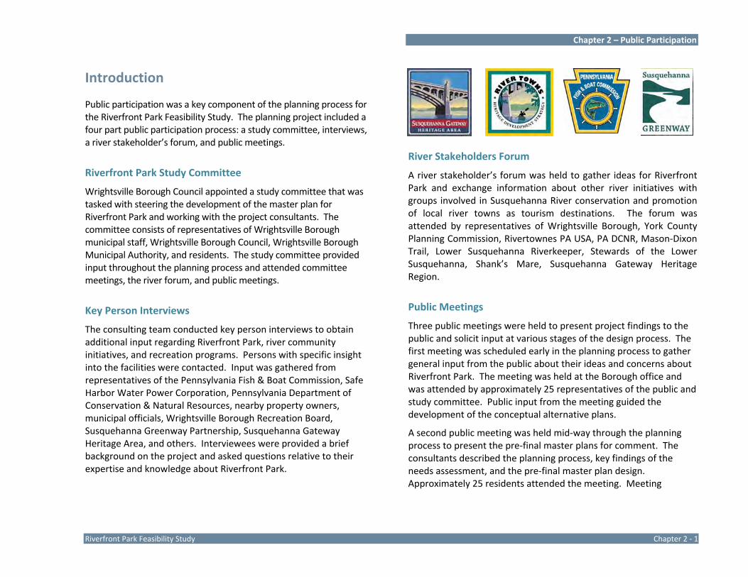
Public participation was a key component of the planning process for the Riverfront Park Feasibility Study. The planning project included a four part public participation process: a study committee, interviews, a river stakeholder’s forum, and public meetings.
Riverfront Park Study Committee
Wrightsville Borough Council appointed a study committee that was tasked with steering the development of the master plan for Riverfront Park and working with the project consultants. The committee consists of representatives of Wrightsville Borough municipal staff, Wrightsville Borough Council, Wrightsville Borough Municipal Authority, and residents. The study committee provided input throughout the planning process and attended committee meetings, the river forum, and public meetings.
Key Person Interviews
The consulting team conducted key person interviews to obtain additional input regarding Riverfront Park, river community initiatives, and recreation programs. Persons with specific insight into the facilities were contacted. Input was gathered from representatives of the Pennsylvania Fish & Boat Commission, Safe Harbor Water Power Corporation, Pennsylvania Department of Conservation & Natural Resources, nearby property owners, municipal officials, Wrightsville Borough Recreation Board, Susquehanna Greenway Partnership, Susquehanna Gateway Heritage Area, and others. Interviewees were provided a brief background on the project and asked questions relative to their expertise and knowledge about Riverfront Park.
River Stakeholders Forum
A river stakeholder’s forum was held to gather ideas for Riverfront Park and exchange information about other river initiatives with groups involved in Susquehanna River conservation and promotion of local river towns as tourism destinations. The forum was attended by representatives of Wrightsville Borough, York County Planning Commission, Rivertownes PA USA, PA DCNR, Mason‐Dixon Trail, Lower Susquehanna Riverkeeper, Stewards of the Lower Susquehanna, Shank’s Mare, Susquehanna Gateway Heritage Region.
Public Meetings
Three public meetings were held to present project findings to the public and solicit input at various stages of the design process. The first meeting was scheduled early in the planning process to gather general input from the public about their ideas and concerns about Riverfront Park. The meeting was held at the Borough office and was attended by approximately 25 representatives of the public and study committee. Public input from the meeting guided the development of the conceptual alternative plans.
A second public meeting was held mid‐way through the planning process to present the pre‐final master plans for comment. The consultants described the planning process, key findings of the needs assessment, and the pre‐final master plan design. Approximately 25 residents attended the meeting. Meeting

Chapter 2 – Public Participation
Chapter 2 ‐ 2 Riverfront Park Feasibility Study
discussion focused on explaination of the design, parking concerns, and the possibility of relocating the existing baseball field offsite.
The final public meeting to present the master plan for Riverfront Park was held on October 17, 2011. Each of the three public meetings were promoted through the local papers and flyers that were posted in public facilities encouraging the public to attend and voice their thoughts on the Riverfront Park Master Plan.
Findings of the Public Participation Process
General
The river setting and river access are main attractions of the park site.
River rescues are typically launched from the Lancaster side of the river.
Streetscape improvements are critical to the park.
The 90’ baseline baseball field at Wrightsville Elementary School is available for community use and there is also an area available for a small t‐ball field.
Park Use
Consider integrating opportunities for art in the park.
The existing parking area is well used, but not necessarily for the park or boat ramp. Patrons of the businesses on Front Street use the parking area. Parking for park and river activities is highest on weekends.
The river access ramp is used in the winter for access to blinds to hunt waterfowl.
The Lemon Street river access ramp is popular for fishing and would be more popular if improved.
Inappropriate activities in the park have decreased since the vegetation has been cleared along the river.
Better access to the river should be provided.
Wrightsville Baseball uses the baseball fields in the park in the spring. The fields flood annually and the Borough cleans up the debris. The fields flood quickly in a flooding event and the water lies on the fields after flood waters have receded.
Baseball participation has been consistent over the past several years with two‐three t‐ball teams, two teams of 8‐10 year olds, and one team of 11‐13 year olds.
Special events should be accommodated in the park. Riverfront Park is the only public river location in the region with open land not bisected by the Norfolk‐ Southern railroad.
There are few opportunities for public camping along the river. Camping should be considered as a park use by permit only.
Facilities
An amphitheater would be popular for movies, music, and plays.
The PA Fish & Boat Commission ramp is well used. An estimate of use is half small trailered boats and half paddle craft.
Citizens want more riverfront access for fishing.
Chapter 2 – Public Participation
Riverfront Park Feasibility Study Chapter 2 ‐ 3
Ice damage is an issue with piers and docks on the river. Consider seasonal facilities that are removed in the winter months.
There are a lot of requests for portable toilets by anglers and boaters using the park.
Establishing a fishing pier on the old railroad piers is a good idea. A pier would increase fishing opportunities with natural fish habitat found around pier foundations. Piers are popular for more than fishing. They are destination for viewing the river, bird watching, and socializing.
Residents would like a trail connecting Commons Park with Riverfront Park and improved walking trails in the park.
The informal parking area along Front Street needs to be addressed.
The basketball court is very popular.
There are two baseball fields developed on Municipal Authority land at Vine Street. The fields are relatively new (6‐7 years old) and nice but not used during the summers of 2010 and 2011. The fields are available for use. A football field is being developed at the site and a concession stand and playground are planned.
Consider restoration of the canal. There is stagnant water in the canal, with the potential for breeding mosquitoes in the summer. The canal’s closed depressions need to be opened up so that water flows to the river. Hugh Moore Park is an example of a park with a canal.
There are constraints with moving the boat ramp associated with the canal and archeological issues. The Fish & Boat Commission boat ramp was rebuilt 5‐7 years ago in same location previously disturbed. The ramp, access drive and
parking were graded and stabilized and the parking expanded.
The playground, pavilion, and basketball court are older facilities that need upgrading.
Tourism
Wrightsville has a rich history that could be explored through interpretive information within the park to draw visitors to the park and town.
The park could be a stop along the Civil War Trail that goes through Wrightsville and highlights the Rewalt House. The Civil War Trail highlights events and stories of the Civil War. The park provides a picturesque view of the Wrightsville Memorial Bridge and stone piers of the former railroad bridge and a vantage point to tell the story of the Second Columbia Bridge burned to stop the advance of the Confederate Army to Philadelphia.
The Mason‐Dixon Trail goes through Wrightsville and could be re‐routed to go through Riverfront Park.
The John Wright Restaurant and Factory Store is a destination for locals and visitors to the area and improvements are planned to these facilities and the Hellam Street area that will further promote Wrightsville as a destination. There is potential for industrial interpretation of the foundry in the future.
The story of Wrightsville as the “Colonial Gateway to the West” could be explored in the park.
The historic lighting project for Veteran’s Memorial Bridge will be constructed in 2011.

Chapter 2 – Public Participation
Chapter 2 ‐ 4 Riverfront Park Feasibility Study
Bicycle PA Route S crosses the Susquehanna River on the Route 462 bridge.
The Northwest River Trail extends from the north to the Borough of Columbia on the east shore of the river and connection could be made to Wrightsville via the Route 462 bridge.
Wrightsville is a stop on the Lower Susquehanna River Water Trail.
Management
PA Fish & Boat Commission Wildlife Conservation Officer visits the park daily.
PA Fish & Boat Commission does not allow camping on their properties.
The PA Fish & Boat Commission lease with Safe Harbor Power Corporation was renewed in 2005 for 10 years.
Borough Police see no crime related problems with the park. They patrol the park a couple times a day and clearing of vegetation along the river has helped reduce issues.
Wrightsville Borough Public Works cleans up the park following flood events.
There are many volunteers in the community.
There is currently no zoning in the Borough.
Project Goals
The following goals were defined for Riverfront Park based on the findings of the planning and public participation process.
Meet the recreation needs of Borough residents as well as visitors to the area.
Celebrate the unique history of the site and community within the park.
Provide a diverse variety of recreation opportunities to serve people of differing ages, interests, and abilities.
Enhance and upgrade facilities, address accessibility and safety issues, and improve park function.

Chapter 3 Resource Analysis

Chapter 3 ‐ Resource Analysis
FeRiverfront Park Feasibility Study Chapter 3 ‐ 1
Introduction
Riverfront Park is an existing community park developed with facilities for river access and self‐directed and organized community recreation. Natural resources are associated with the Susquehanna River and its riparian corridor. An inventory and analysis of the park’s resources was completed early in the planning process and subsequent field work was undertaken to view the park throughout the four seasons.
A comprehensive resource inventory and analysis is critical to guide park planning. Park inventory and analysis:
Defines areas that contain sensitive resources that should be protected, buffered, and/or enhanced.
Considers the ability of resources to sustain and thrive with the continuation, addition, or introduction of public use.
Explores resources that contribute to the visitor’s experience.
Evaluates man‐made features to determine their appropriateness and utility in the park setting and ability to continue to meet user needs in the future.
Explores the context of the park site and surrounding area/ region.
Investigates potential site characteristics or resources that pose development or use limitations, concerns for health and safety of park visitors, or other concerns.
Explores existing user patterns, maintenance practices, and functional considerations.
Good park design and relevant park master plans are born of a comprehensive resource analysis. Exploration of Riverfront Park was the first critical step in creating a future vision for the park.
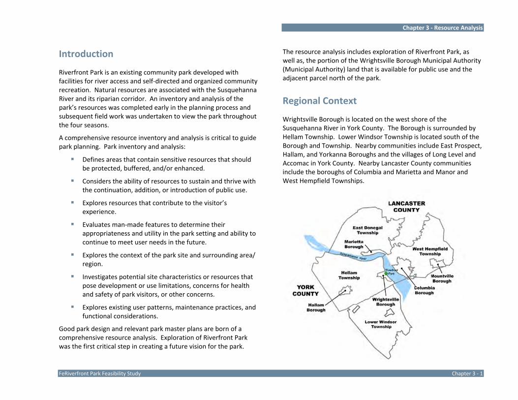
The resource analysis includes exploration of Riverfront Park, as well as, the portion of the Wrightsville Borough Municipal Authority (Municipal Authority) land that is available for public use and the adjacent parcel north of the park.
Regional Context
Wrightsville Borough is located on the west shore of the Susquehanna River in York County. The Borough is surrounded by Hellam Township. Lower Windsor Township is located south of the Borough and Township. Nearby communities include East Prospect, Hallam, and Yorkanna Boroughs and the villages of Long Level and Accomac in York County. Nearby Lancaster County communities include the boroughs of Columbia and Marietta and Manor and West Hempfield Townships.

Chapter 3 ‐ Resource Analysis
Chapter 3 ‐ 2 Riverfront Park Feasibility Study
Wrightsville is closely linked to the river and nearby river communities through shared history and resources. Columbia, Marietta, and Wrightsville have similar assets, opportunities, and challenges. Through the River Towns Heritage Development Strategy and initiatives of the Susquehanna Gateway Heritage Area these communities have developed a synergy and momentum for community resurgence.
Expanded recreation and tourism opportunities, open space preservation, and state and private investment in the region has created momentum for Wrightsville and other communities in the region to undergo revitalization and prosper as attractive places to live, work, and explore.
Parks, protected open space, and regional initiatives in the area of Wrightsville Borough and Riverfront Park include the following:
Commons Park, a Wrightsville Borough park located north of the John Wright Restaurant includes a boat ramp and small picnic area.
Transfer of approximately 3,500 acres of natural lands along the Susquehanna River from the PPL Corporation to the Lancaster County Conservancy.
Permanent protection of Wilton Meadow by the Lancaster County Conservancy. This 45 acre tract is located in Hellam Township and provides expansive views of the Susquehanna River.
The historic lighting project on the Veteran’s Memorial Bridge between Wrightsville and Columbia Boroughs.
Development of York County Department of Parks and Recreation ‐ Highpoint Scenic Vista & Recreation Area. A 79‐acre park with scenic views of the Susquehanna River. The Mason‐Dixon Trail traverses this park site.
Kline’s Run Park, owned by the Safe Harbor Water Power Corporation, provides picnic areas and scenic views of the Susquehanna River. The Mason‐Dixon Trail traverses this park site.
Native Lands County Park, a 187 acre park located contiguous to Kline’s Run Park and is traversed by the Mason‐Dixon Trail traverses the site and a portion of the trail is designated as the Native Lands Heritage Trail, which explores historic features of the site and area.
Columbia Borough River Park was recently renovated to provide enhanced access to the river.
Regional Connections
Wrightsville Borough and Riverfront Park are located at the crossroads of several trails and greenway initiatives to include:
The Susquehanna Greenway ‐ The Susquehanna Greenway extends along 500 miles of the Susquehanna River in Pennsylvania, linking existing greenways, water trails, and other scenic and historic or cultural places.
The Mason‐Dixon Trail – The 193‐mile Mason‐Dixon Trail traverses parts of Pennsylvania, Maryland, and Delaware. The eastern terminus is in Chadds Ford, Chester County where it meets the Brandywine Trail. The western terminus is in Whiskey Springs, west of Dillsburg, York County where the Mason‐Dixon Trail meets the Appalachian Trail. The Mason‐Dixon Trail is a hiking trail located on public and private lands and

Chapter 3 ‐ Resource Analysis
FeRiverfront Park Feasibility Study Chapter 3 ‐ 3
along roadways. A portion of the trail traverses Riverfront Park.
The Northwest River Trail – The Northwest River Trail is a 14‐mile recreation trail planned for the eastern shore of the Susquehanna River between Columbia Borough and Conoy Township, Lancaster County. Portions of the trail have been developed and others are in the planning and funding stage. The southern terminus of the trail is Columbia which is linked to Wrightsville Borough via Veteran’s Memorial Bridge (Route 462).
Pennsylvania Bicycle Route S ‐ Bicycle PA Route S crosses the Susquehanna River on Veteran’s Memorial Bridge. Route S extends from the Delaware River in Bucks County to the western boundary of the state with West Virginia in Washington County. Route S passes through the cities of Lancaster and York and the boroughs of Columbia and Wrightsville.
Lower Susquehanna River Water Trail – Wrightsville Borough is a waypoint along the Lower Susquehanna River Water Trail. Commons Park and Riverfront Park are access points. The lower section of the water trail stretches from the New Market Boat Access near Harrisburg, Pennsylvania and ends a few miles south of the Mason‐Dixon Line at the Broad Creek Access in Maryland.
The section of the Susquehanna River Water Trail from Sunbury to the Maryland border joins a statewide network of land and water‐based trails totaling more than 1500 miles. It is one of
only a few water trails in the state designated as a National Recreation Trail. National Recreation Trails are components of the National Trails System, recognition of trails that connect people to resources and improve their quality of life.
PA Highlands Trail – The Appalachian Mountain Club is collaboratively planning a trail network that will protect and connect the ecological, historic, and recreational assets of the Pennsylvania Highlands and provide outdoor recreational opportunities. The PA Highlands Trail Network will extend the Highlands Trail (130 miles in New York and New Jersey) along the length of the Pennsylvania Highlands, from the Delaware River at Rieglesville, PA south to the Maryland border in south‐central PA. Encompassing roughly 1.9 million acres, the Pennsylvania Highlands includes portions of 13 counties (Bucks, Montgomery, Northampton, Lehigh, Chester, Berks, Lancaster, Lebanon, Dauphin, Cumberland, Franklin, Adams, and York). The Highlands Trail will align with existing trails where possible. In the study area, the Highland Trail will follow the Northwest River Trail south to Columbia, cross Veteran’s Memorial Bridge, and continue north on the Mason‐Dixon Trail to meet the Appalachian Trail in Western York County.
Civil War Trails ‐ The Civil War Trails explores areas involved in the Civil War. Riverfront Park provides a picturesque view of the stone piers of the former railroad bridge and a vantage point to tell the story of the Second Columbia Bridge burned by the Pennsylvania Militia to stop the advance of the Confederate Army to Philadelphia.
Chapter 3 ‐ Resource Analysis
Chapter 3 ‐ 4 Riverfront Park Feasibility Study
Riverfront Park Assessment of Feasibility
Riverfront Park exists through the collaborative efforts and cooperation of several entities. The property is owned by one entity and leased to two other entities. The leased areas overlap but are not coincidental. Management and maintenance of the property is provided by one of the lessees while the other monitors the use of the site. These activities all happen in a way that is shielded from the public. The public benefits from these arrangements but only see a public park that they can use for a variety of recreation activities throughout the year.
This planning process explored the feasibility of continuing to offer the site as a public park and undertaking enhancements to the property based on the recommendations of this planning project. Issues of ownership, lease agreements, lease terms and restrictions, lands under other ownership, and future park related opportunities associated with the property have been explored.
Ownership – Riverfront Park is owned by Safe Harbor Water Power Corporation. The park property is approximately 16.7 acres in size. A property line survey is not available for the site.
Safe Harbor Water Power Corporation generates hydroelectricity at Safe Harbor Dam located on the Susquehanna River south of Wrightsville. The dam creates Lake Clarke, an 11.5 square mile lake that provides diverse opportunities for water sport enthusiasts. Safe Harbor Water Power Corporation also operates recreation areas that provide boating, picnicking, plant tours, water skiing, fishing, hiking, and game commission services. The company was incorporated in 1930 and is based in Conestoga, Pennsylvania. Safe Harbor operates a 420‐megawatt hydroelectric power plant on the Susquehanna River, which is used primarily to meet peak demands for electricity. A subsidiary of Constellation Generation Group owns two‐thirds of the plant, while LS Power owns one‐third.
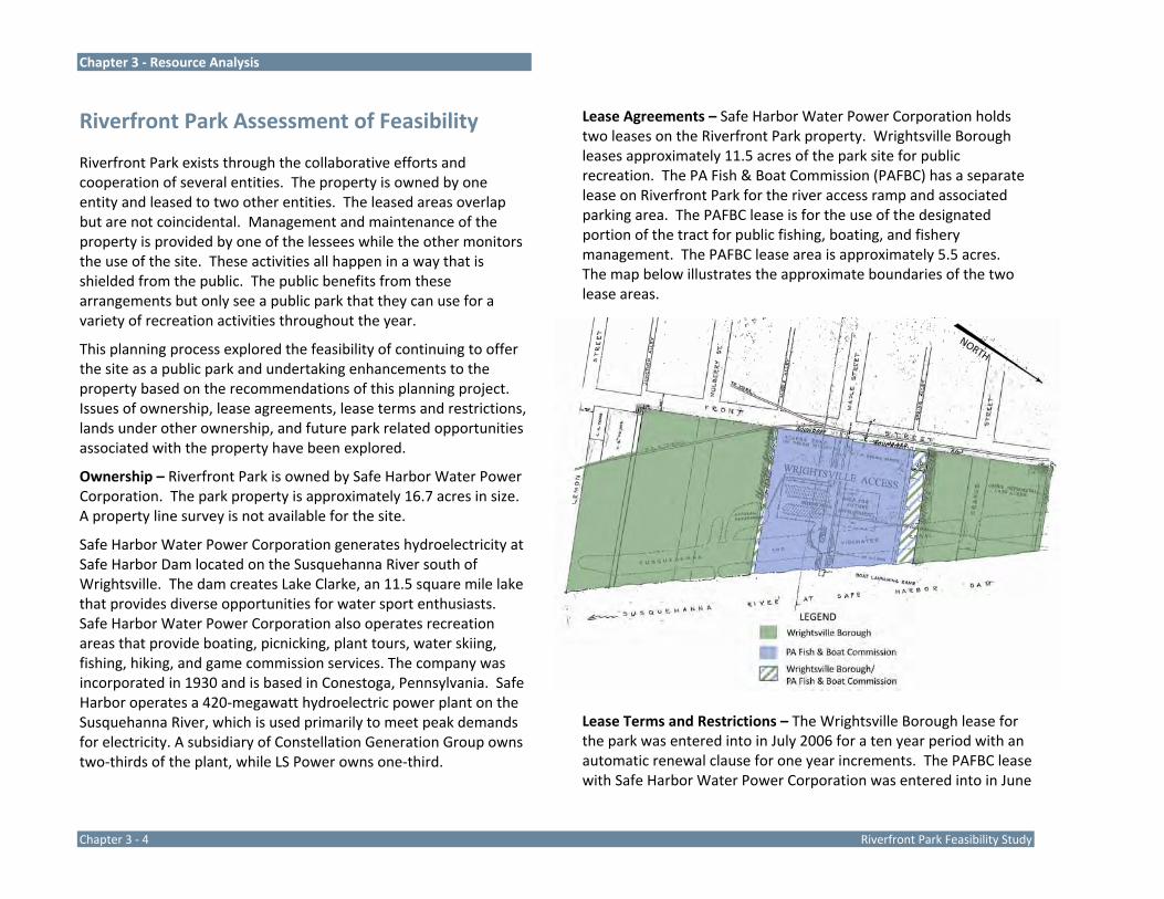
Lease Agreements – Safe Harbor Water Power Corporation holds two leases on the Riverfront Park property. Wrightsville Borough leases approximately 11.5 acres of the park site for public recreation. The PA Fish & Boat Commission (PAFBC) has a separate lease on Riverfront Park for the river access ramp and associated parking area. The PAFBC lease is for the use of the designated portion of the tract for public fishing, boating, and fishery management. The PAFBC lease area is approximately 5.5 acres. The map below illustrates the approximate boundaries of the two lease areas.
Lease Terms and Restrictions – The Wrightsville Borough lease for the park was entered into in July 2006 for a ten year period with an automatic renewal clause for one year increments. The PAFBC lease with Safe Harbor Water Power Corporation was entered into in June

Chapter 3 ‐ Resource Analysis
FeRiverfront Park Feasibility Study Chapter 3 ‐ 5
2005 for a ten year term with an automatic renewal clause on a one year increment.
Discussions with a representative of Safe Harbor Water Power Corporation explored the terms of the two leases. The length of the lease (10 years) is determined by the license that Safe Harbor Water Power Corporation has on the property with the Federal Energy Regulatory Commission (FERC). Safe Harbor Water Power Corporation has a license to operate the Safe Harbor Dam from the FERC through the end of 2030. The longest lease Safe Harbor Water Power Corporation would consider for the property is through 2030, to align with the FERC license, but their standard and preferred lease term is 10 years.
Summary of key lease terms of the Wrightsville Borough Lease include:
Use of Property – Tenant will only use property for “personal and/or private recreational use,” except on the express written approval of the Landlord.
Condition of Property – Tenant understands that Landlord will make no repairs, additions, or changes to the property except as follows: None.
Tenant’s Care of Property – Tenant will: 1) Keep the property clean and safe, 2) Get rid of all trash, garbage and any other waste materials as required by Landlord and the law, 3) All buildings, shall at all times, be kept in a good state of repair by the Tenant, 4) Maintain property within the local township or boro ordinances. Tenant will not: 1) Keep any flammable materials on the property, except as described in the property rules, 2) Willfully destroy or deface any part of the property, 3) Disturb the peace and quiet of other tenants or neighbors, 4) Post sign or signs on any part of the demised premises without written consent of the Landlord, 5) Make changes to the property, without
the written permission of Landlord. Tenant understands that any changes or improvements made or constructed, that cannot or are not removed, will become the property of the Landlord, upon termination of this lease.
Summary of key lease terms of the PA Fish & Boat Commission Lease include:
Facility Development – a) The Commission shall design improvements for the Premises to facilitate and enhance public fishing, boating and fishery management, b) The Commission shall be responsible for the construction, development, operation and maintenance of the Improvements designed by the Commission, c) The Commission may develop, enlarge and maintain additional enhancements on the Premises that may enhance public fishing, boating and fishery management with the prior written approval of the Owner, d) The Owner may, in its discretion, develop, construct, operate and maintain additional enhancements on the Premises and utilize the Premises so long as such actions and related use does not have an adverse impact on public fishing, boating and fishery management thereon.
Free Access – During the term of this agreement the Premises shall be open to the public without charge for fishing, boating, fishery management and parking related thereto. The public shall have unrestricted free access to the Premises via the closest public road.
The Commission shall be responsible for all maintenance, operation, repair and supervision of the Premises related to its rights of public fishing, boating and fishery management granted herein.
Additionally, the Borough Lease attached Recreation Site Maintenance Guidelines, which are included as part of the lease.
Chapter 3 ‐ Resource Analysis
Chapter 3 ‐ 6 Riverfront Park Feasibility Study
The provisions of this document address the requirement for ongoing maintenance, removal of trash and debris, and cleaning up following flooding events. Live trees may not be cut without authorization of SHWPC. Additionally, the Recreation Site Maintenance Guidelines cites the River Basin Flood Act and the Flood Plain Management Report dated August 12, 1981. These documents are held by the Susquehanna River Basin Commission (SRBC) and relate to the health of the Chesapeake Bay. These provisions place limitations on the erection or installation of new buildings and cite several exceptions. There are two open pavilions and a low stage proposed for the park that are located within the floodplain. These pavilions are envisions as simple structures with corner posts and a roof that would not impede the free flow of flood waters and the stage could be developed to be removable if necessary. The SRBC must be involved in future discussions regarding improvements in the floodplain and these structures should be developed in accordance with all governing floodplain regulations.
Lands Under Other Ownership – The Wrightsville Borough Municipal Authority owns land south of the park that is available, in part, for public use. The Municipal Authority has granted a 50‐foot wide access easement for a trail along the river between Riverfront Park and Kreutz Creek and along Kreutz Creek from the river to Water Street. The Municipal Authority land of the former Electroplaters of York, Inc. property is also available for park development. This portion of the Municipal Authority land is approximately 5.6 acres.
The planning process also included consideration of lands north of the park owned by Donsco Incorporated, a cast iron foundry and manufacturer of cast parts. The Donsco lands considered within the planning process include approximately 1.6 acres located between the north property line of the Safe Harbor Water Power Corporation park site and the Route 462 bridge. This land, while owned by
Donsco, is visually connected to the park site and does not include improvements associated with the foundry.
Park Related Opportunities – Safe Harbor Water Power Corporation has indicated through interviews with the property superintendent that there is no current interest in selling the park property. The rationale is that the property is already a public park and Riverfront Park is included in the Federal Energy Regulatory Commission license boundary. The Federal Energy Regulatory Commission boundary was redrawn in 2010 and is not redrawn on a regular interval.
The proposed park improvements envisioned by the master plan were reviewed with a Safe Harbor Water Power Corporation representative. The representative stated that the improvements are permitted but must be recreation in nature, available for public use, and do not include permanent structures that could be inhabited. Open structures such as pavilion or single purpose structures (e.g. restrooms) are permitted.
Funding for improvements must come from other sources and Safe Harbor Water Power Corporation will not fund improvements to the site. Safe Harbor Water Power Corporation’s contribution to public recreation is ownership of the land.
The aforementioned lands to the north (Donsco) and south (Wrightsville Borough Municipal Authority) expand upon the recreation opportunities available at Riverfront Park by providing additional property for recreation development, riverfront land, and areas for historic/cultural interpretation.
Findings of Feasibility
A Safe Harbor Water Power Corporation representative has reviewed the master plan for Riverfront Park and has indicated, through discussion as part of this planning process that the proposed improvements are compatible with the property and allowed by the lease agreements. Both leases require the written
Chapter 3 ‐ Resource Analysis
FeRiverfront Park Feasibility Study Chapter 3 ‐ 7
permission of Safe Harbor Water Power Corporation to make changes or improvements to the property. Both leases require that the lessees allow the public free access to the property. Both leases require that improvements to the site be made at the expense of the lessees and that the improvements become the property of Safe Harbor Water Power Corporation if abandoned.
Safe Harbor Water Power Corporation has indicated that they are not currently interested in selling the park property or amending the lease to a longer term based on the requirements of their license agreement with the Federal Energy Regulatory Commission. The current 10 year lease is less than the minimum term lease PA Department of Conservation and Natural Resources (PA DCNR) requires for eligibility to apply for park development funding through the PA DCNR C2P2 Community Recreation and Conservation grants. PA DCNR C2P2 Community Recreation and Conservation grants require an applicant to own the project site or control the site through a lease of 25 years or more in duration. It should be noted that the Commonwealth of Pennsylvania has funded improvements to the site through the PA Fish & Boat Commission, within the parameters of a 10 year lease period. Safe Harbor Water Power Corporation has indicated through a letter that the company supports the recommendations of this Master Site Plan for Riverfront Park and future planning on the property.
Additionally, the Wrightsville Borough Municipal Authority has indicated that they support the park development recommendations for the former Electroplaters of York portion of their property and trail easement. Donsco Incorporated has indicated through interviews that they are open to the future development of the small portion of the Donsco property south of the Route 462 bridge as park land and the extension of a trail along the river to connect to the proposed fishing pier. Further discussions and an easement agreement will be required.
The structures proposed within the floodplain will have to be reviewed and approved by the Susquehanna River Basin Commission due to the park site being covered by the River Basin Flood Act and the Flood Plain Management Report dated August 12, 1981.
Development of the park as envisioned by the Riverfront Park Master Plan is feasible from an ownership and physical landscape perspective based on the interviews with owner and lease representatives. Ownership by Safe Harbor Water Power Corporation and the relatively short‐term lease timeframes with Wrightsville Borough and the PA Fish & Boat Commission may exclude the possibility of grant funding for park development from the Pennsylvania Department of Conservation and Natural Resources.
The master plan was developed using GIS base mapping information, including the delineation of the 100‐year floodplain. A site‐defined accurate location of the 100‐year floodplain will be required to proceed with development of park improvements. The accurate location of the floodplain may necessitate minor modification to the design to move the two restroom structures outside of the floodplain area and to have other structures comply with floodplain regulations. These minor modifications should be able to be accommodated while maintaining the concepts promoted on the master plan.

Chapter 3 ‐ Resource Analysis
Chapter 3 ‐ 8 Riverfront Park Feasibility Study
Riverfront Park Site Analysis
The Riverfront Park Site Analysis Map is provided at the end of this chapter.
General Site Data
Size / Location – Riverfront Park is approximately 16.7 acres in size. The parcel is on the west bank of the river in Wrightsville Borough. The portion of the Wrightsville Borough Municipal Authority property that is available for park development and public use is approximately 5.6 acres. The Municipal Authority land is located contiguous to Riverfront Park to the south and includes the municipal sewage treatment facilities. The public portion of the tract includes the former Electroplaters of York Inc. property and a 50‐foot wide easement along the riverfront that extends south to Kreutz Creek and along Kreutz Creek from the river to Water Street. The portion of the Donsco property between the north park boundary and the Route 462 bridge is approximately 1.6 acres.
Existing and Surrounding Land Use – The parcel exists as a park with open lawn areas, vegetated riparian areas, and recreation amenities. Surrounding land use includes industrial uses to the north and residential uses to the west and south. Two commercial establishments are in close proximity to the park: the Riverfront Bar and the Wrightsville Inn, both on Front Street. John Wright Store and Restaurant are within a short one‐third mile walk from the park and Hake’s Sporting Goods is located southwest of the park on Front Street. Hellam Street is targeted for redevelopment and can be reached from the park via Front Street. Borough and Municipal Authority offices are located adjacent to the south side of the park on Water Street.
Donsco Inc. an industrial foundry of cast parts owns land to the north of the park site, including the stone ruins in the area of the
former Susquehanna and Tidewater Canal adjacent to Riverfront Park and riverfront land between Riverfront Park and Commons Park. The Donsco property, is opposite the piers from the Second Columbia Bridge and is divided by the right‐of‐way for the Route 462 bridge. Donsco maintains a small paved parking area and materials yard on the south side of the Route 462 bridge. These facilities and the industrial facilities north of the bridge extend nearly to the river shore, limiting opportunities to develop a river trail. North of the Donsco property is Commons Park, a small Wrightsville Borough park with a river access ramp. Connecting Commons Park and Riverfront Park is a long‐term goal for the borough.
Zoning – Currently there is no zoning in the Borough.
Water Resources
River – The Susquehanna River is approximately one mile wide in the area of the park. The park has approximately 1,600 feet of river frontage and the adjacent Municipal Authority land provides an additional 1,300 feet available for public use for a total of over one‐half mile of riverfront land.
Throughout the course of a year, the river corridor withstands heavy spring flows, low flow periods during the summer, periodic floods, and ice flows during the winter. Flooding occurs seasonally.
The river maintains populations of small mouth bass, large mouth bass, walleye, American shad, trout, carp, catfish, suckers, and other species. There are no signs or advisories posted at the boat launch to inform anglers and boaters about the spread of invasive aquatic species. Zebra mussels are invasive aquatic mussels that are spreading throughout freshwater systems. Zebra mussels survive in the residual water remaining in livewells, bilge water, and watercrafts not cleaned between water bodies.
Chapter 3 ‐ Resource Analysis
FeRiverfront Park Feasibility Study Chapter 3 ‐ 9
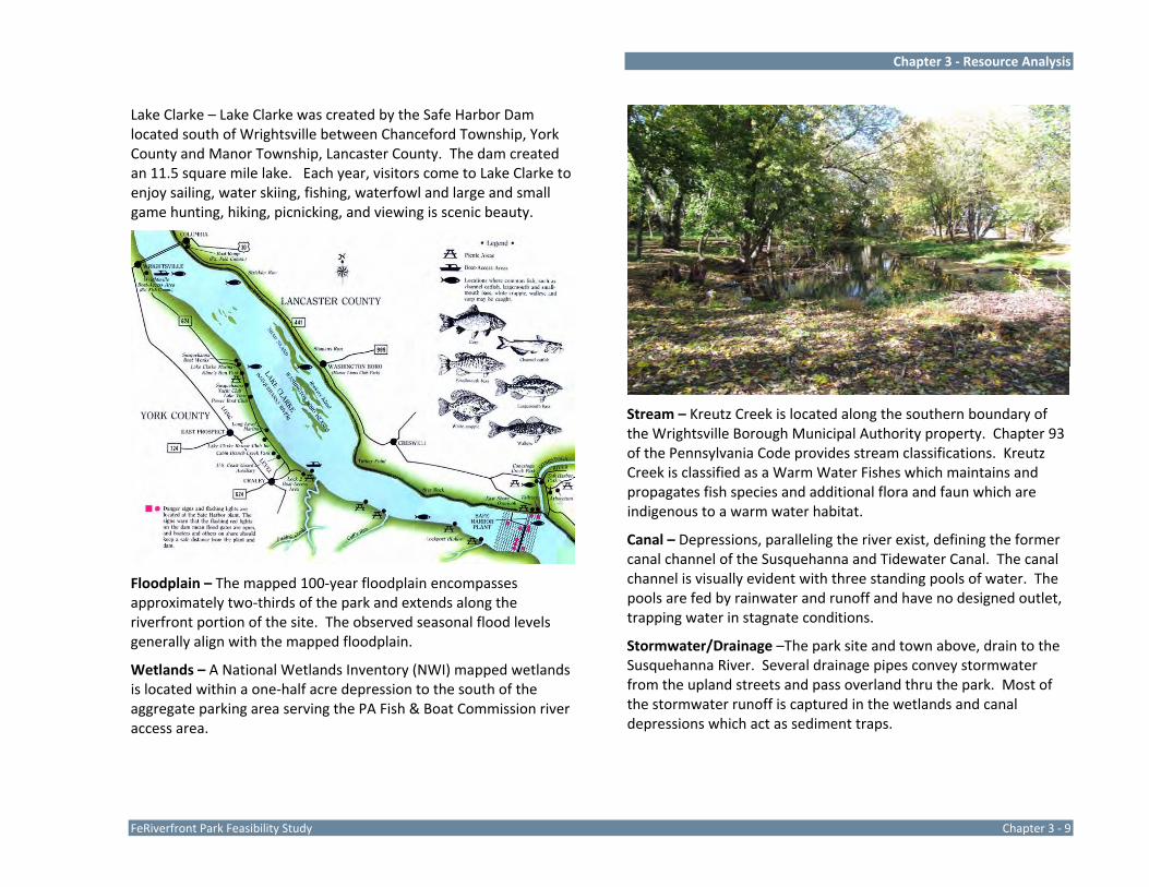
Lake Clarke – Lake Clarke was created by the Safe Harbor Dam located south of Wrightsville between Chanceford Township, York County and Manor Township, Lancaster County. The dam created an 11.5 square mile lake. Each year, visitors come to Lake Clarke to enjoy sailing, water skiing, fishing, waterfowl and large and small game hunting, hiking, picnicking, and viewing is scenic beauty.
Floodplain – The mapped 100‐year floodplain encompasses approximately two‐thirds of the park and extends along the riverfront portion of the site. The observed seasonal flood levels generally align with the mapped floodplain.
Wetlands – A National Wetlands Inventory (NWI) mapped wetlands is located within a one‐half acre depression to the south of the aggregate parking area serving the PA Fish & Boat Commission river access area.
Stream – Kreutz Creek is located along the southern boundary of the Wrightsville Borough Municipal Authority property. Chapter 93 of the Pennsylvania Code provides stream classifications. Kreutz Creek is classified as a Warm Water Fishes which maintains and propagates fish species and additional flora and faun which are indigenous to a warm water habitat.
Canal – Depressions, paralleling the river exist, defining the former canal channel of the Susquehanna and Tidewater Canal. The canal channel is visually evident with three standing pools of water. The pools are fed by rainwater and runoff and have no designed outlet, trapping water in stagnate conditions.
Stormwater/Drainage –The park site and town above, drain to the Susquehanna River. Several drainage pipes convey stormwater from the upland streets and pass overland thru the park. Most of the stormwater runoff is captured in the wetlands and canal depressions which act as sediment traps.

Chapter 3 ‐ Resource Analysis
Chapter 3 ‐ 10 Riverfront Park Feasibility Study
Land Resources
Soils – Soils are identified and described on the Site Analysis Map. Two soil classifications are present on the park site, which have the following characteristics.
Soils Cd – Chagrin silt loam UeB – Urban land – Conestoga complex
Slope 0‐3% 0‐8%
Depth to Bedrock very deep very deep
Seasonal Water Table 48‐72 inches > 60 inches
Flooding Potential occasional none
Hydric no no
Topography – The site generally slopes from Front Street to the river and contains typical floodplain topography with shallow slopes and depressions in the area of the former canal. The floodplain/floodway occupies the lower elevations, to the toe of slope. The grade changes mark typical high water and floodplain elevations. A soil berm encircles the baseball field, trapping flood waters for extended periods. The site has steep sloped areas that transition between Front Street and the lower level of the park and between the playground area and the baseball field. Vegetation – The park has a variety of mixed mature deciduous trees, riparian vegetation, and lawn areas. The vegetation is predominantly oriented along the waters edge and is primarily deciduous trees, with minimal understory. Numerous mature canopy trees are scattered throughout the lawn areas. The vegetation obscures river views from Front Street. In 2010 the Borough utilized Bureau of Corrections labor to clear out much of the overgrown vegetation along the river. This clearing opened partial views to the river from the park and Front Street.
Riparian Buffer – The vegetation along the riparian corridor includes American sycamore, red maple, ash, silver maple, and an abundance of pioneer and opportunistic species. Large trees in the riparian corridor are critical for riverbank stabilization.
Invasive Species – There was evidence of multi‐flora rose and grape vine within the riparian corridor. Riparian areas are difficult to protect from invasive species and weed seeds which are often transported by flood waters.
Wildlife Habitat – The riparian corridor’s mature trees provide important nesting and roosting habitat. Small mammals such as squirrels, chipmunks, rabbits, and mice would typically occupy the site.
Views – The park site affords picturesque river views. With the current vegetative cover, open views are provided from the two boat ramps at the extension of Maple Street and Lemon Street, as well as, at the extension of Orange Street. Veteran’s Memorial

Chapter 3 ‐ Resource Analysis
FeRiverfront Park Feasibility Study Chapter 3 ‐ 11
Bridge is the dominant view from the river’s edge. The shoreline of the Municipal Authority property offers the best long view of the bridge.
Man‐Made Resources and Influences
Site Access / Vehicular Circulation – Access to Riverfront Park is via the street network of Wrightsville Borough. Front Street parallels the west boundary of most of the park site providing vehicular access at the intersection of Orange and Maple Streets. Lemon Street extends into the park from its intersection with Water Street and provides access to the Municipal Authority land. Maple Street provides direct access to the PAFBC river access ramp and is considered the main park entrance. The Orange Street Access into the park is unimproved. Sidewalks are provided on the west side of Front Street.
Trails – There are no existing trails or sidewalks within the park. Informal earthen paths extend along the embankment between the canal depressions and the river.
Utilities / Infrastructure –
Electric ‐ Electric service currently extends to the existing picnic pavilion and to a security light near the basketball court.
Water – Water is available in Front Street.
Sanitary – Sanitary lines are located in Front Street, up slope of the park. The Wrightsville Borough Municipal Authority sewage treatment plant is located south of the park.
Structures – There are four structures in the park: a pavilion, a concession stand, a storage garage, and a stone memorial.
Chapter 3 ‐ Resource Analysis
Chapter 3 ‐ 12 Riverfront Park Feasibility Study
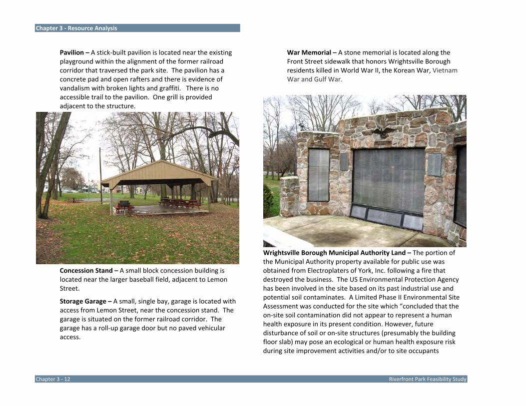
Pavilion – A stick‐built pavilion is located near the existing playground within the alignment of the former railroad corridor that traversed the park site. The pavilion has a concrete pad and open rafters and there is evidence of vandalism with broken lights and graffiti. There is no accessible trail to the pavilion. One grill is provided adjacent to the structure.
Concession Stand – A small block concession building is located near the larger baseball field, adjacent to Lemon Street.
Storage Garage – A small, single bay, garage is located with access from Lemon Street, near the concession stand. The garage is situated on the former railroad corridor. The garage has a roll‐up garage door but no paved vehicular access.
War Memorial – A stone memorial is located along the Front Street sidewalk that honors Wrightsville Borough residents killed in World War II, the Korean War, Vietnam War and Gulf War.
Wrightsville Borough Municipal Authority Land – The portion of the Municipal Authority property available for public use was obtained from Electroplaters of York, Inc. following a fire that destroyed the business. The US Environmental Protection Agency has been involved in the site based on its past industrial use and potential soil contaminates. A Limited Phase II Environmental Site Assessment was conducted for the site which “concluded that the on‐site soil contamination did not appear to represent a human health exposure in its present condition. However, future disturbance of soil or on‐site structures (presumably the building floor slab) may pose an ecological or human health exposure risk during site improvement activities and/or to site occupants

Chapter 3 ‐ Resource Analysis
FeRiverfront Park Feasibility Study Chapter 3 ‐ 13
subsequent to property redevelopment. Furthermore, the EPA report recommends removal and /or capping of the former facility building with “clean fill” in order to prevent direct contact/human exposure with the soil contamination.” A large block building which fronts on the extension of Lemon Street is part of the property. The building is currently unoccupied and not used by the Municipal Authority. Renovation potential is limited by the deteriorated state of the structure and environmental concerns.
Recreation Facilities – Traditional recreation facilities are located on the southern side of the park and include two baseball fields, a playground, a basketball court, and a pavilion.
Baseball Fields – The larger field, known as Field No. 1, has a 60‐foot baseline with a right field length of 285’, center field of 267’, left field of 189’, and block dugouts. The solar orientation of this field is acceptable with the batter facing the northeast. The smaller field, known as Field No. 2, also has a 60‐foot baseline but has a poor solar orientation with the batter facing southeast. The outfield lengths of this field vary from 140; in right field, to 212’ in center field, and 176’ in left field. Both fields are irregular and shorter than the minimum 200‐foot outfield that is typically provided for 60‐foot baseline fields. Both baseball fields are developed with outfield and sideline fencing, backstops, and a fence separating the two fields.
Both baseball fields are located entirely in the 100‐year floodplain and are seasonally underwater due to flooding. The fence that separates the two fields runs east‐west perpendicular to the river flow and catches debris during flooding conditions. Baseball and softball are traditional spring sports and use of the fields is often postponed while the fields are under water or drying out from flood events
The close proximity of the fields, the short dimensions of the outfield, and the seasonal flooding and debris
accumulation in the fencing make the fields less than desirable for competitive play. On the positive side the embankments to the north, south, and west provide natural seating areas for viewing games and the location provides spectators a spectacular view of the river.
Playground – Playground equipment is located in the lawn area adjacent to the basketball court and picnic pavilion near Front Street. Play equipment includes one swing structure (2 bays, 4 swings) a see‐saw structure with four see‐saws, a merry‐go‐round, and a small plastic modular structure with a slide. There is no safety surfacing provided with the equipment and the equipment is not accessible. Each piece is of an age and condition that warrants removal for non‐compliance with safety and accessibility guidelines. There is no accessible route to the playground.

Chapter 3 ‐ Resource Analysis
Chapter 3 ‐ 14 Riverfront Park Feasibility Study
Basketball Court – A small 40’ x 80’ basketball court is located near Front Street in the area of the picnic pavilion and playground. The court is oriented north‐south on the former railroad bed and the surface area does not extend beyond the basketball standards. The pavement surface is in good condition. No up‐slope drainage is provided to divert runoff away from the court. The court is popular and often in use. Two benches are located one on each side of the court and the slope embankment between the road and the court provides additional spectator seating.
Boat Ramps – There are two boat ramps in the park; at the extension of Maple and Lemon Streets. The Maple Street boat ramp and the surrounding area are leased by the PA Fish & Boat Commission. The boat ramp is a submerged concrete structure with access via an asphalt and aggregate drive convenient to parking. A Lower Susquehanna River
Water Trail sign and a historic interpretative sign are located adjacent to the ramp.
A second boat ramp is located at the terminus of Lemon Street. The Lemon Street pavement extends into the river. Both ramps provide boat access to shallow water at normal water elevations. At normal river water elevations the ramps are used to launch paddle craft, Jon boats, and other flat‐bottom vessels.
Support Facilities –
Parking – Three areas of parking exist in Riverfront Park. The main parking area is the aggregate lot associated with the PA Fish & Boat Commission river access area at Maple Street. This parking area is unmarked but sized for vehicle with trailers and can accommodate approximately 48 vehicles with trailers or 100 cars. A small, aggregate head‐
Chapter 3 ‐ Resource Analysis
FeRiverfront Park Feasibility Study Chapter 3 ‐ 15
in parking area is provided off of Lemon Street, south of the large baseball field. This parking area can accommodate approximately 15 vehicles. An informal aggregate parking aisle is provided on the east side of, and parallel to, Front Street between Maple and Orange Streets. This parking area is used by residents living on Front Street and patrons of the Riverfront Bar. On‐street parking is permitted on the west side of Front Street and on Water Street.
Portable Toilet – A single portable toilet is located on the southwest side of the main parking area at the time of the site analysis. The structure is removed seasonally, to avoid flood waters.
Historic and Cultural Resources
Wrightsville Borough and the region played an active role in the history of the nation and Riverfront Park provides a unique location to learn about the events and activities that occurred in the Borough and surround area.
Wrightsville is named for John Wright an early pioneer who originally settled on the east bank of the Susquehanna in 1728. Shortly thereafter, he took land for farming on the west bank under the Penn license and in 1730 established a ferry to move other licensed settlers to the west bank. The Borough of Wrightsville was incorporated in 1834 with the merger of two settlements, the original village of Wrightsville and the town of Westphalia to the south.1
The River Crossings – 2 Wrightsville was the gateway to the west and a major point of crossing of the Susquehanna River.
1 Our Townes. Rivertownes PA USA. June 30, 2011. http://www.rivertownes.org/townes.htm 2 Crossings at Rivertownes. Rivertownes PA USA. June 30, 2011. http://www.rivertownes.org/Features/Crossings/Crossings.htm
Ferries ‐ Wright’s Ferry was established in 1730 crossing from Wrightsville to Columbia followed by Anderson’s Ferry in 1737 crossing from Accomac to Marietta.
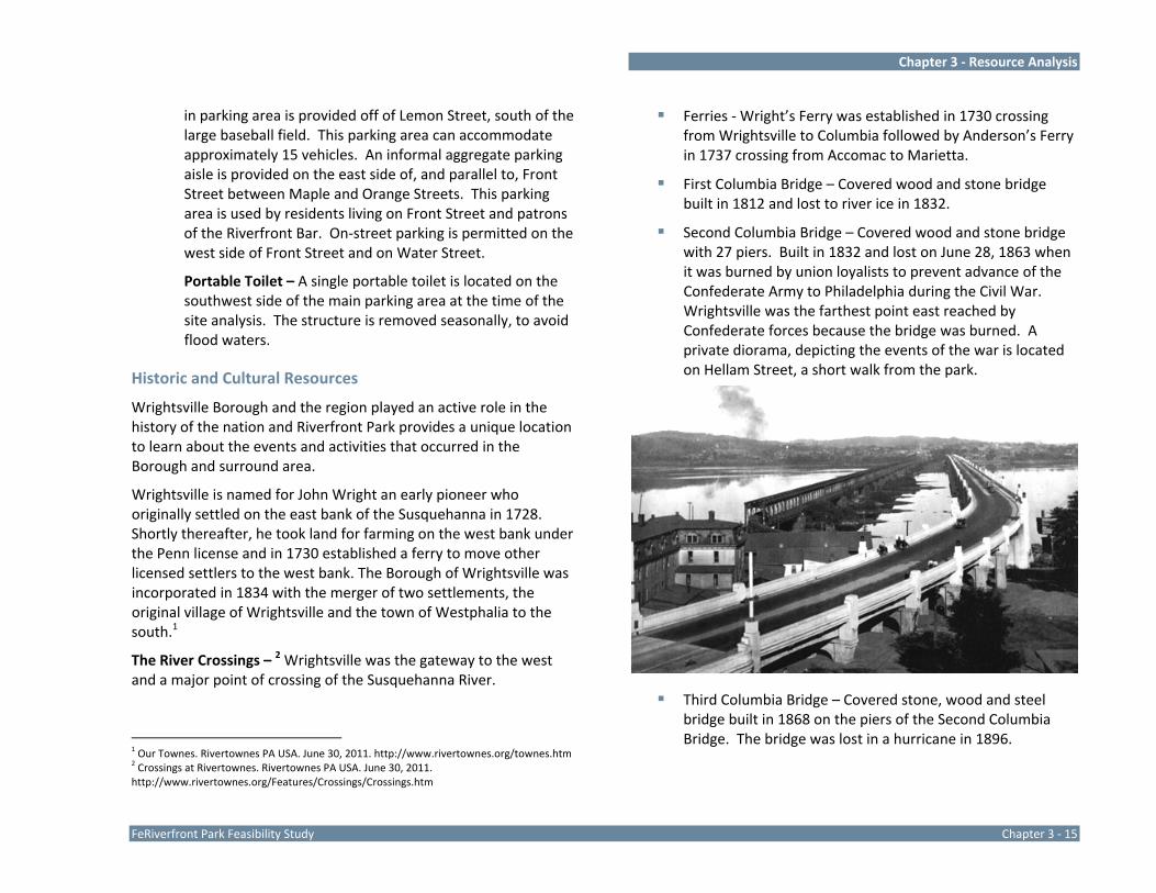
First Columbia Bridge – Covered wood and stone bridge built in 1812 and lost to river ice in 1832.
Second Columbia Bridge – Covered wood and stone bridge with 27 piers. Built in 1832 and lost on June 28, 1863 when it was burned by union loyalists to prevent advance of the Confederate Army to Philadelphia during the Civil War. Wrightsville was the farthest point east reached by Confederate forces because the bridge was burned. A private diorama, depicting the events of the war is located on Hellam Street, a short walk from the park.
Third Columbia Bridge – Covered stone, wood and steel bridge built in 1868 on the piers of the Second Columbia Bridge. The bridge was lost in a hurricane in 1896.
Chapter 3 ‐ Resource Analysis
Chapter 3 ‐ 16 Riverfront Park Feasibility Study
Pennsylvania Railroad “Iron” Bridge – Steel and stone structure built in 1897 on the stone piers of the Second Columbia Bridge. The bridge carried the rail line and twin carriageways shared with pedestrians. The bridge was dismantled for scrap in 1963 but the stone piers remain.
Veteran’s Memorial Bridge – This reinforced concrete bridge is located adjacent to the south boundary of Riverfront Park and dominates the northern river view from the park. The bridge has 27 piers in the river and 22 piers on the two approaches. The bridge was built in 1929 and is State Route 462.
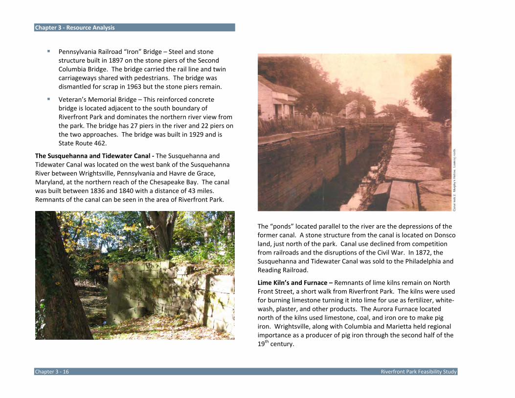
The Susquehanna and Tidewater Canal ‐ The Susquehanna and Tidewater Canal was located on the west bank of the Susquehanna River between Wrightsville, Pennsylvania and Havre de Grace, Maryland, at the northern reach of the Chesapeake Bay. The canal was built between 1836 and 1840 with a distance of 43 miles. Remnants of the canal can be seen in the area of Riverfront Park.
The “ponds” located parallel to the river are the depressions of the former canal. A stone structure from the canal is located on Donsco land, just north of the park. Canal use declined from competition from railroads and the disruptions of the Civil War. In 1872, the Susquehanna and Tidewater Canal was sold to the Philadelphia and Reading Railroad.
Lime Kiln’s and Furnace – Remnants of lime kilns remain on North Front Street, a short walk from Riverfront Park. The kilns were used for burning limestone turning it into lime for use as fertilizer, white‐wash, plaster, and other products. The Aurora Furnace located north of the kilns used limestone, coal, and iron ore to make pig iron. Wrightsville, along with Columbia and Marietta held regional importance as a producer of pig iron through the second half of the 19th century.

Chapter 3 ‐ Resource Analysis
FeRiverfront Park Feasibility Study Chapter 3 ‐ 17
Industrial Heritage – Wrightsville’s waterfront was dominated by industry based on use of the Susquehanna and Tidewater Canal and the York & Wrightsville Railroad. Lumber, metals, and quarrying were dominating industries. Riverfront Park was the site of a lumberyard in the 1800’s and the eastern terminus of the York & Wrightsville Railroad.
Resource Analysis Conclusions and Planning Implications
Ecological –
It is important to maintain a healthy vegetated riparian corridor with large, mature trees to hold the river banks during ice scour and prevent significant erosion. Minimize
man‐made disturbances along the riparian corridor that could negatively impact mature trees.
The river is a wildlife corridor. Encourage riparian buffer vegetation that provides habitat and will attract diverse wildlife and be more inviting for migration waterfowl.
Increase and enhance the vegetative buffer along the river to protect the banks from erosion, filter pollutants before they reach the river, and reduce the negative effects of seasonal flooding and ice scouring.
The Susquehanna River, canal ponds, Kreutz Creek, and wetlands offer diverse opportunity to study a variety of natural systems for environmental education.
The pools of water at the canal depressions are stagnant and separated from the river flow. The depressions are dependant of rain water and runoff for supply and have no outlets.
The wetlands boundary should be delineated. The NWI Maps indicate wetland areas and disturbance to these areas will require environmental permits.
Monitor and remove invasive species along the river banks.
The park and adjacent Municipal Authority land provide over ½ mile of public riverfront land.
The floodplain and prominent transition to upland topography dominate the site and dictate improvement locations.
Thinning of vegetation could open strategic views to the river from Front Street.

Chapter 3 ‐ Resource Analysis
Chapter 3 ‐ 18 Riverfront Park Feasibility Study
Functional –
Provide handicap accessible parking spaces and an accessible walkway/trail throughout the park site to connect parking areas and park facilities. ADA accessibility should be addressed to each facility.
Develop modern restrooms that meet the requirements of the ADA, are vandal resistant, and located beyond the 100‐year floodplain.
Front Street offers a superior view into the park, facilitating visual surveillance.
Development of sidewalks on the east side of Front Street should be explored to connect to existing sidewalks north and south of the park.
Having adequate parking in the area of Front Street is a major concern of residents. Residents currently park on park property parallel to Front Street between Maple and Orange Streets. If this parking area is removed, it should be replaced to maintain, or exceed, the current space count.
The aggregate parking area associated with the PAFBC boat launch is large and undefined. Consider defining parking areas and turnarounds to limit paved areas and increase lawn area.
Enhance the Lemon Street boat ramp to promote additional river access and convenience.
Portions of the Municipal Authority land are not open to the public and the park design must direct users to public areas and discourage access to other areas.
The elevation change from Front Street to the lower park area and river edge is a challenge for ADA access.
Explore safe pedestrian connection between Riverfront Park and Commons Park, the Lime Kilns, Hellam Street, the Wrightsville Historical Society, and other local points of interest and business destinations.
Recreational –
The river and views to Veteran’s Memorial Bridge make the park a premier destination along the river. Promote the park as a destination for recreation, community events, and river activities. Provide user friendly amenities for accessing the site from the river.
The Maple Street boat launch is well used. The depth of water at the launch is relatively shallow, limiting the type of boats that use the launch to paddle‐craft and flat bottom boats.
The open lawn below Front Street is gently sloping and offers flexible space for special events. The hillside from Front Street to the lower lawn areas offers a preferred orientation for viewing early evening events with the sun setting behind spectator’s sitting on the sloped lawn.
The baseball fields are well used but problematic. The larger field is well oriented and offers adequate outfield distances. The smaller youth field is short and not well oriented, with the harsh setting sun in pitcher’s and fielder’s eyes. Both fields are poorly drained. A berm has been developed between the river and baseball fields, which blocks the retreat of flood water after a flood event. The fence between the fields limits field size and catches debris during flood events. The area offers 2.5‐acres of gently sloped lawn area, with ongoing flooding issues. Consider relocating the ball fields off‐site to provide correct orientation, full size fields, foul ball safety zones, and facility
Chapter 3 ‐ Resource Analysis
FeRiverfront Park Feasibility Study Chapter 3 ‐ 19
amenities without the ongoing maintenance associated with flooding.
The physical relationship of the playground near the baseball fields is good. The playground is an accessory amenity for use by young children who quickly loose interest in ballgames. The playground located near the basketball court is not ideal as the user groups are not compatible. Young children at the playground should not be adjacent to a facility typically used by older children who may use inappropriate language.
Remove the outdated playground equipment and provide a playground that meets the latest safety and accessibility standards, including safety surfacing.
It is important to work with Donsco to secure the opportunity to incorporate the stone canal remnant into the park as an interpretative feature and explore the best option for access along the river to the north to the stone bridge piers remnants, John Wright store and restaurant, the lime kilns and furnace along Front Street, and Commons Park.
Renovate/replace the pavilion.
The point where Kreutz Creek empties into the river is interesting, offering great views north and south along the river. The stone abutment at the former creek crossing is an interesting feature, which could be interpreted.
The park offers open areas appropriate for the informal enjoyment of the site for its river access and scenic views.
Trail connections north along the river are limited by available shoreline under the Route 462 bridge and the Donsco property. Connections downstream are limited by Kreutz Creek, residential property (owned by Safe Harbor
Water Power Corporation) and eventually steep slopes and private property. Route 624 offers potential connections to destinations north and south. A northern route is readily available with sidewalk along Front Street. The southern route present challenges associated with the narrow, winding shoulder of Route 624.
Introduce additional recreational amenities desired by park visitors such as horseshoe pits, volleyball court, and a nature trail along the river.
An accessible trail along the river would be a popular facility. The Mason‐Dixon Trail route passes through the park and could use future park trails. The Mason‐Dixon Trail connects the park with High Point Scenic Vista & Recreation Area, the Native Lands County Park, and other protected land along the river.
Cultural –
The Borough and park site are rich in history which should be incorporated into the park through Interpretative signs, restoration/recreation of structures, and site development features.
Overall, Riverfront Park has tremendous opportunity to be the hub of recreation and community activities in Wrightsville. It has a prominent location between the town hub and river, a scenic setting overlooking the river and Veteran’s Memorial bridge, and history that adds interest to the setting and draws visitors. Environmental concerns regarding flooding, wetlands and topography will influence the park master plan and ultimate development. Riverfront Park should be viewed as a local asset as well as a key component of the Lower Susquehanna River region.
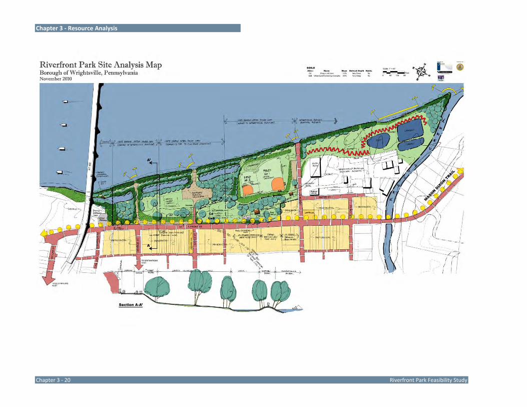
Chapter 3 ‐ Resource Analysis
Chapter 3 ‐ 20 Riverfront Park Feasibility Study

Chapter 4 Conceptual Alternatives


Chapter 4 – Conceptual Alternatives
Riverfront Park Feasibility Study Chapter 4 ‐ 1
Conceptual alternative designs were completed for Riverfront Park with consideration of the goals and objectives established by the master planning process, inventory and analysis of the park site and surrounding area, and public input. The Conceptual Alternative designs explored different options for park development and rehabilitation and illustrate potential facility configurations and relationships. The study committee reviewed the Conceptual Alternatives and provided input and direction for development of the Pre‐Final Master Plan.
Riverfront Park’s location along the Susquehanna River creates a regional recreation destination for boaters, paddlers, anglers, and others who enjoy spending time outdoors. The park offers an opportunity to launch or stop and rest as you travel down the river. The river is the site’s most significant asset but also presents the most critical land planning concern. The site floods annually and much of the site falls within the 100‐year floodplain. The conceptual alternatives consider seasonal flooding and the effects on the park site.
Both conceptual alternatives celebrate the historic aspects of the park site and community. The Susquehanna and Tidewater Canal, York & Wrightsville Railroad, the lumber industry, and the burning of the Second Columbia Bridge are all significant historic stories that can be told within the park. Interpretative signs and sculpture are suggested in both designs to share these stories.
Both conceptual alternatives create spaces for community events, informal recreation, and river access. Trails are incorporated into each design and the Mason‐Dixon Trail is routed through the park.
Conceptual Alternative A
The design opens up the canal to the river and removed the PAFBC access ramp at Maple Street while improving the river access at
Lemon Street. A water control weir is located at the mouth to the canal to control the flow of water to the canal. The weir can be closed in the winter so that ice can form on the canal for ice skating. A sculptural element is suggested to interpret the canal era use of the site. Ideas for the sculpture include a canal boat and/or mule. Arch bridges similar to bridges noted in historic photographs provide access to the land on the east side of the canal.
The northern portion of the park is maintained as open lawn for special events and informal use. A stage is introduced which is located on the west side of the canal for use during special events, small concerts, or movie nights. The natural sloping hillside provides informal amphitheater seating and provides the preferred orientation for viewing a stage, with spectators facing east.
The baseball field is removed in this alternative, opening area for additional recreation facilities desired by residents. Two basketball courts are provided with expanded separation from the playground. Two picnic areas are developed with adjacent open lawn and lawn games. The playground is completely renovated in the same general area as it currently exists. The former railroad bed is developed as the accessible path through the playground and sculptural railroad elements are suggested to reflect the railroad history.
The Municipal Authority land is developed with a community center building and parking. A plaza and great lawn are developed between the building and the river. Exterior access is provided to restrooms in the community center building.
The entire riparian buffer is enhanced with vegetation to stabilize the riverbank. River access is improved by providing multiple stabilized river access location, a seasonal dock, a fishing dock and an elevated boardwalk and pier north of the park site.
Trails extend along the river edge and throughout the park to provide access to facilities and provide loops for walking. Vehicle

Chapter 4 – Conceptual Alternatives
Chapter 4‐2 Riverfront Park Feasibiliity Study
and boat trailer parking is located on the north side of Lemon Street, convenient to the launch ramp and turn‐around loop. Front Street is reconfigured to provide parking on the west side of the street with reverse angle parking. Sidewalk and curb bulbouts, crosswalks, street tree planting, and a wall along the park frontage will enhance the aesthetics of the area, calm traffic on Front Street, and improve pedestrian safety. The wall is envisioned as a decorative feature that draws from the pier and arch forms of Veteran’s Memorial Bridge. Plaza spaces are introduced at the park entrances.
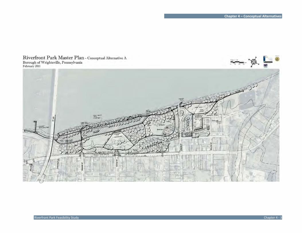
Chapter 4 – Conceptual Alternatives
Riverfront Park Feasibility Study Chapter 4 ‐ 3
Chapter 4 – Conceptual Alternatives
Chapter 4‐4 Riverfront Park Feasibiliity Study
Conceptual Alternative B
The design establishes the canal as two ponds that are engineered to eliminate the standing water. The PAFBC river access is maintained between the two ponds. A “floating” stage is developed on the larger pond to compliment the lawn amphitheater. The stage is configured to resemble a canal boat. The amphitheater has both lawn seating and seat walls to accommodate spectators.
The larger baseball field is retained in the design and provided with a 250‐foot outfield and skinned infield. Bleachers are built into the sloped lawn on the third base side. The playground is located near its existing location and upgraded with new equipment and seat walls. The basketball court is relocated to the Municipal Authority land and an in‐line hockey rink is added.
Picnic opportunities are introduced to the north of the playground, at the basketball court, and at the river overlook on the Municipal Authority land.
Parking and an improved turn‐around are provided via the Maple Street river access area. Additional parking is provided on the north side of Lemon Street adjacent to the baseball field and on the east side of the street to serve the sports courts and plaza and lawn area. Reverse angle parking is develop on the east side of Front Street, near the proposed amphitheater. Parking is suggested on Water Street to serve the municipal office and proposed storage building. Restrooms are provided in stand‐alone structures near the playground and near the in‐line courts.
Trails extend along the river edge and throughout the park to provide access to facilities and provide loops for walking.
The entire riparian buffer is enhanced with vegetation to stabilize the riverbank. River access is improved by providing multiple stabilized river access location, courtesy docks at Maple Street and Lemon Street, and an overlook. The Lemon Street river access is
maintained and a back‐up space is provided for paddle‐craft drop‐off.

Chapter 4 – Conceptual Alternatives
Riverfront Park Feasibility Study Chapter 4 ‐ 5

Chapter 4 – Conceptual Alternatives
Chapter 4‐6 Riverfront Park Feasibiliity Study
The Study Committee reviewed the two conceptual alternatives for Riverfront Park and preferred elements of each design. The committee offered the following guidance for the development of the Pre‐Final Master Plan design.
Explore commercial development on the Municipal Authority land in lieu of the community center.
The back‐in parking on the residential side of Front Street was preferred.
The PA Fish & Boat Commission river access ramp should remain at Maple Street.
Incorporate the walls on the river side of Front Street.
Open up the canal and replace the culvert under the boat ramp.
Eliminate the baseball field.
Build upon the railroad theme for the playground.
The game courts and picnic pavilions located north of Lemon Street was preferred.
Add a skate park in lieu of an in‐line skate rink.
Retain the great lawn on the Municipal Authority land.
Conceptual Alternative A Positive Negative
The canal is opened up to the river. The PAFBC river access ramp is eliminated.
The open lawn, natural hill, and stage provide opportunities for special events and small performances.
Restrooms are limited to the community center.
Parking on Front Street will calm traffic and the reverse angle parking will provide a buffer between traffic and pedestrians and provide additional parking spaces.
Parking is not convenient to the lawn amphitheater/special events area.
The baseball field is removed eliminating an ongoing issue associated with flooding and debris cleanup.
The boardwalk/pier is a unique feature that will attract anglers, bird watchers, and the casual visitor.
Conceptual Alternative B Positive Negative
The PAFBC river access ramp is maintained.
The baseball field is located in an area that floods annually.
The baseball field is developed with full size outfield, without outfield fence.
A road separates the courts from the baseball field and playground.
Restrooms are provided in two locations and relate to high use areas.
Engineering solutions will be required to maintain the ponds in a non‐stagnant condition.
Parking is located throughout the sites. The open lawn, natural hill, and stage provide opportunities for special events and small performances.

Chapter 4 – Conceptual Alternatives
Riverfront Park Feasibility Study Chapter 4 ‐ 7
Pre‐Final Design The Pre‐Final Master Plan was developed for Riverfront Park to reflect input from the Study Committee and general public. The pre‐final design is a consolidation of the ideas and input from review of the Conceptual Alternatives into one cohesive master plan for the park site. The Pre‐Final Master Plan was presented to the Study Committee at a project meeting and no substantive changes were recommended. A public meeting was held at the municipal building to present the Pre‐Final Master Plan to the general public. The meeting was attended by residents, municipal representatives, and the Study Committee. The Pre‐Final Master Plan is illustrated on the next page.

Chapter 4 – Conceptual Alternatives
Chapter 4‐8 Riverfront Park Feasibiliity Study

Chapter 5 Park Master Plan


Chapter 5 – Park Master Plan
Riverfront Park Feasibility Study Chapter 5 ‐ 1
Introduction
The Riverfront Park Master Plan illustrates the overall vision for the park and Municipal Authority properties, the physical configuration of proposed improvements, and strategies for resource enhancements. The Master Plan was developed after thoughtful consideration of input from citizens, the Study Committee, park users, and municipal representatives.
Recreation Opportunities
Riverfront Park offers a diverse array of recreation opportunities, from natural resource‐based recreation associated with the river to community recreation, and historic education. The range of public recreation opportunities provided at Riverfront Park is listed below.
Resource Based Recreation – Riverfront Park and the adjoining Municipal Authority land protect approximately one‐half mile of Susquehanna River shoreline, as well as a wetland area. Fishing, hunting (on the river), bird watching, boating, and nature study opportunities are found in the park.
Historic Education – The resources and settings of the park present opportunities for learning about the history of Wrightsville and its roll in transportation, early industry, and the Civil War.
Traditional Recreation – Riverfront Park provides a unique natural setting for spending time with family and friends. Picnic areas, a playground, fishing areas and facilities, trails, the amphitheater, and open space for games and activities are the backdrops for lifetime memories.
Group Outings and Programs – The picnic areas, pavilions, and open lawn areas provide space for families; community organizations such as the scout groups, school ecology clubs, service
clubs; and others to gather at the parks for their programs. The amphitheater provides a venue to group presentations.
Self‐Directed Activities – Non‐scheduled time is a premium for many as we get caught up in the hectic pace of our day to day lives. Riverfront Park provides a place to visit where activities are not scheduled, where visitors can enjoy the park setting and facilities at their own pace and on their own terms.
Fitness and Wellness – Fitness extends lives, improves self‐image, reduces health care costs, reduces isolation, and makes people happier. The park provides areas for people to walk and jog and spend time being active in the outdoors. If weather permits, ice skating may be possible on the canal ponds.
Special Events Space – The amphitheater lawn, lawn near the basketball courts, and lawn on the Municipal Authority land are areas that can be programmed for special events. The two proposed restrooms, parking, and drop‐off areas will support large gatherings.
Riverfront Park Master Plan The Riverfront Park Master Plan redesigns the park to provide additional day use facilities; protects and buffers the park’s significant resource, the Susquehanna River; and celebrates the history of the park and community.
The importance of the park as a destination along the Lower Susquehanna River Water Trail has been recognized with improvements that target the needs of boaters traveling on the water trail.
Recreation and Leisure Facilities
The Master Plan proposes a complete renovation of the park facilities. Although some of the facilities are retained in relatively the same
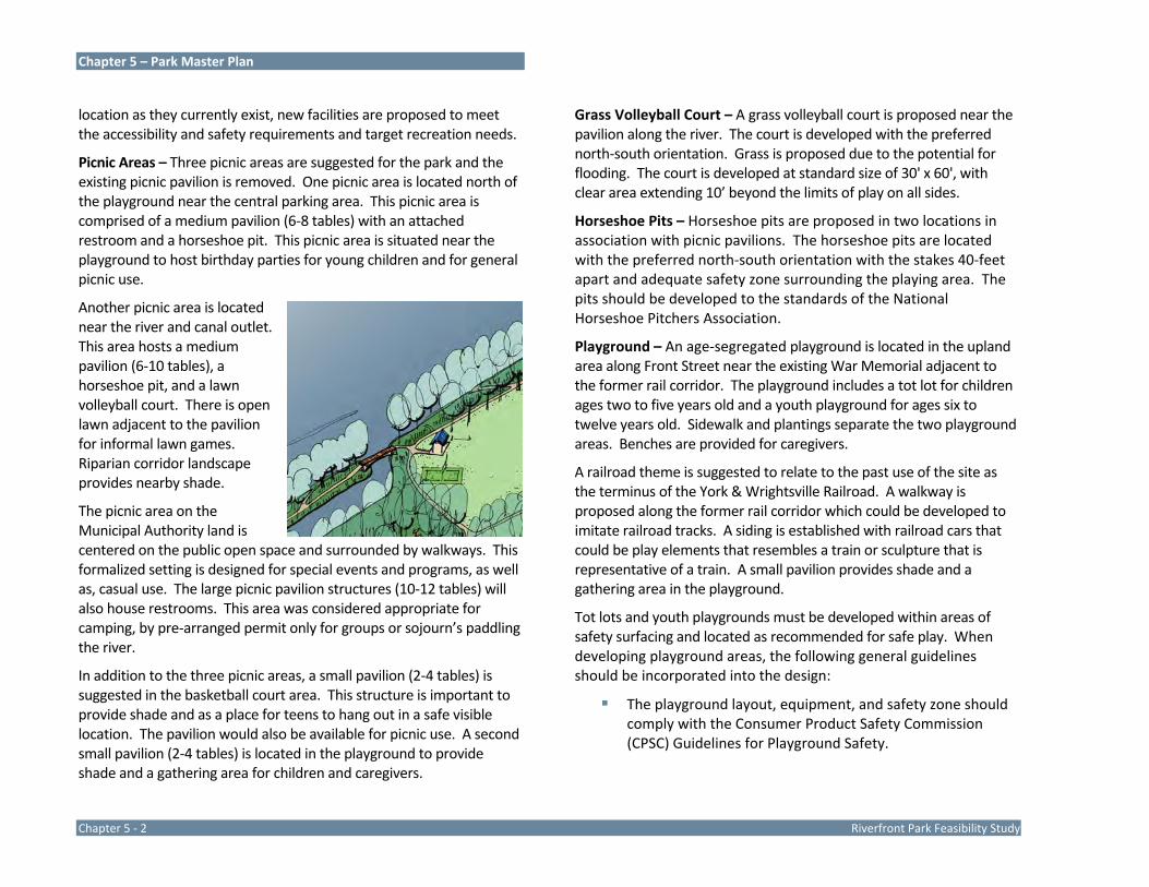
Chapter 5 – Park Master Plan
Chapter 5 ‐ 2 Riverfront Park Feasibility Study
location as they currently exist, new facilities are proposed to meet the accessibility and safety requirements and target recreation needs.
Picnic Areas – Three picnic areas are suggested for the park and the existing picnic pavilion is removed. One picnic area is located north of the playground near the central parking area. This picnic area is comprised of a medium pavilion (6‐8 tables) with an attached restroom and a horseshoe pit. This picnic area is situated near the playground to host birthday parties for young children and for general picnic use.
Another picnic area is located near the river and canal outlet. This area hosts a medium pavilion (6‐10 tables), a horseshoe pit, and a lawn volleyball court. There is open lawn adjacent to the pavilion for informal lawn games. Riparian corridor landscape provides nearby shade.
The picnic area on the Municipal Authority land is centered on the public open space and surrounded by walkways. This formalized setting is designed for special events and programs, as well as, casual use. The large picnic pavilion structures (10‐12 tables) will also house restrooms. This area was considered appropriate for camping, by pre‐arranged permit only for groups or sojourn’s paddling the river.
In addition to the three picnic areas, a small pavilion (2‐4 tables) is suggested in the basketball court area. This structure is important to provide shade and as a place for teens to hang out in a safe visible location. The pavilion would also be available for picnic use. A second small pavilion (2‐4 tables) is located in the playground to provide shade and a gathering area for children and caregivers.
Grass Volleyball Court – A grass volleyball court is proposed near the pavilion along the river. The court is developed with the preferred north‐south orientation. Grass is proposed due to the potential for flooding. The court is developed at standard size of 30' x 60', with clear area extending 10’ beyond the limits of play on all sides.
Horseshoe Pits – Horseshoe pits are proposed in two locations in association with picnic pavilions. The horseshoe pits are located with the preferred north‐south orientation with the stakes 40‐feet apart and adequate safety zone surrounding the playing area. The pits should be developed to the standards of the National Horseshoe Pitchers Association.
Playground – An age‐segregated playground is located in the upland area along Front Street near the existing War Memorial adjacent to the former rail corridor. The playground includes a tot lot for children ages two to five years old and a youth playground for ages six to twelve years old. Sidewalk and plantings separate the two playground areas. Benches are provided for caregivers.
A railroad theme is suggested to relate to the past use of the site as the terminus of the York & Wrightsville Railroad. A walkway is proposed along the former rail corridor which could be developed to imitate railroad tracks. A siding is established with railroad cars that could be play elements that resembles a train or sculpture that is representative of a train. A small pavilion provides shade and a gathering area in the playground.
Tot lots and youth playgrounds must be developed within areas of safety surfacing and located as recommended for safe play. When developing playground areas, the following general guidelines should be incorporated into the design:
The playground layout, equipment, and safety zone should comply with the Consumer Product Safety Commission (CPSC) Guidelines for Playground Safety.

Chapter 5 – Park Master Plan
Riverfront Park Feasibility Study Chapter 5 ‐ 3
Playgrounds must meet the requirements of the Americans with Disabilities Act (ADA) which requires that an accessible route be provided from walkways/parking areas to the playground equipment and that a portion of the equipment offer activities that can be utilized by physically challenged children.
Playgrounds should be age‐segregated to accommodate children of different ages and abilities. The playgrounds should have signs identifying the age appropriate areas of play.
American Society for Testing and Materials references for public playground safety:
- F1487 Standard Consumer Safety Performance Specification for Playground Equipment for Public Use.
- F2373 Standard Consumer Safety Performance specification for Public Use Play Equipment for Children 6 Months through 23 Months.
- F1292 Standard Specification for Impact Attenuation of Surface Systems Under and Around Playground Equipment.
Playgrounds should be designed to stimulate imaginative play as well as physical activity. Playgrounds should be stimulating environments that engage children while providing convenience facilities for adults such as benches and shaded areas.
Teen Area – Basketball courts and a skate park are proposed in an area of the park targeting the needs and interests of teens. Both basketball and skateboarding can be self‐directed activities that can be enjoyed as an individual or with friends and do not require a team organization to participate. The setting, location, and amenities provided in the teen area are specifically tailored to teen use. The location is in an open visible portion of the park. Teen
activities can be readily observed in this area with visual access from Front and Lemon Streets. The adjacent parking area is developed in a loop configuration which allows police patrols to easily monitor activities in the area. The adjacent parking area also provides convenient parking for teens who wish to “hang out” with friends in a safe area. A sloped lawn area on the southwest portion of the teen area is graded to provide lawn and seat wall spectator seating overlooking the facilities.
Basketball Courts – A full‐court and a half‐court basketball courts are proposed for an area of the park geared to the needs and interests of teens. The full‐court is developed at 42’ x 74’, which is the standard PIAA (Pennsylvania Interscholastic Athletic Association) dimensions for a junior high basketball court. The half‐court is developed at 50’ wide by 42’ long, which is one half of the PIAA standard size of for high school basketball courts.
A ten‐foot unobstructed area is provided on all sides of both courts, as recommended. The courts should be developed with 1.25‐1.5 percent slope for proper surface drainage with a north‐south orientation. Lighting is proposed for the courts. A small pavilion is proposed near the courts for resting and gathering in a shaded area between games.
Skate Park – A skate park is proposed for the teen area adjacent to the basketball courts. The skate park proposes a modular ramp system placed on a color‐coated bituminous surface. “No Skate” zones should be delineated surrounding

Chapter 5 – Park Master Plan
Chapter 5 ‐ 4 Riverfront Park Feasibility Study
the skate area to separate skaters from other activities. The modular equipment should be grouped to provide various areas targeting different skill levels and abilities. It is important to note that there are no specific design standards and/or criteria in developing skate parks. Each park must be tailored to meet the individual needs and budget of the community and its skateboarders. Therefore, it is imperative that the local skateboarders be involved in the design and development of the skateboard park. Lighting is proposed for the skate park.
River Access Improvements – One of the objectives for the park improvements is to provide additional, convenient access to the Susquehanna River. River access is proposed to accommodate the casual visitor who enjoys the scenic views across the river expanse as well as outdoor enthusiasts who want to boat or fish in the river.
Stabilized River Access – Several areas along the riverfront are stabilized for river access. These areas are relatively level along the river edge that are stabilized with plastic grid system and aggregate. The areas are connected to an accessible trail and should be located in the field to protect existing mature vegetation.
Seasonal Docks/Fishing Pier – Two seasonal docks or fishing piers are suggested at the two river access ramps. These structures are located on the down‐river side of the ramp and project into the river for fishing or boat tie‐up. The docks/fishing pier would be in place seasonally and removed
for storage through the winter and early spring flood season.
Scenic Overlook – A deck is located on the Municipal Authority land along the river to provide an improved area to view the river scenery. The views north to the Veteran’s Memorial Bridge are impressive from this location. The land is elevated above the river along the Municipal Authority property. An accessible trail provides access to the deck.
Elevated Pier – The stone piers of the Second Columbia Bridge on the north side of the Veteran’s Memorial Bridge provide an opportunity to provide additional access to the Susquehanna River. An elevated pier is proposed that will extend from the shoreline to the first stone pier. The elevated pier would extend approximately 120‐feet into the river to reach the first stone pier. An elevated pier would be popular with anglers as the bridge pier foundations create fish habitat areas. Additionally, the pier would be a unique feature offering views of the shore and river not found elsewhere prompting visitors to stop in Wrightsville and Riverfront Park to enjoy the facility. An access agreement across the Donsco property must be secured.
Boat Ramps – Two boat ramps are improved in the park. The PA Fish & Boat Commission (PAFBC) river access ramp

Chapter 5 – Park Master Plan
Riverfront Park Feasibility Study Chapter 5 ‐ 5
was recently improved by the PAFBC. Additional improvement to the ramp is a seasonal dock/fishing pier. Improvements to the parking area provide a dedicated turn‐around for vehicles with boat trailers to maneuver and 53 parking spaces. The parking areas and access way is paved. The Lemon Street ramp is improved with a seasonal dock/fishing pier and nearby parking spaces. The loop entrance to the parking area provides an area for vehicles to travel prior to backing up into the ramp. Additionally, a stabilized boat staging area is provided for vehicles with paddle craft to stand while the boats are moved to the shoreline.
Canals – The existing stone ruin on the Donsco property should be highlighted as an entrance to the canals. The existing canal depressions should be connected and established as one pond to reflect the former canals. The silt that has deposited in the canal should be removed. The pond shall be equipped with an aeration device to circulate water and prevent stagnation. Controls for the pond should be provided to facilitate the canal freezing. Ice skating had traditionally occurred on the canal and if weather conditions permit is an activity that residents would like to enjoy in the park. Pedestrian access should be developed to carry the trail across the canal.
Amphitheater – An informal lawn amphitheater is developed on the north side of the park. The amphitheater viewing area takes advantage of the sloping lawn. A timber and stone stage is located adjacent to the canal and could be designed to be reminiscent of a canal era structure. The stage location in the east provides the preferred orientation for viewing performances. Low seat walls are informally scattered through the sloped seating area to designate the area of viewing. Lawn chairs and blankets can be placed on the hill to
accommodate other spectators. Walkways traverse the amphitheater area to provide access.
Trails – Trails extend throughout the park to provide accessible routes to facilities and activity areas and provide opportunities for walking and exploring the park. Bituminous pavement is suggested with consideration of accessibility requirements and seasonal flooding. Most of the trails should be developed at a minimum eight foot width for the main trails and a minimum five foot width for minor trails and spurs to the river.
If a more natural looking trail is preferred along the river, stonedust could be used, which when compacted will meet accessibility requirements. The Borough should consider the pros and cons of bituminous versus stonedust in flood prone areas. Stonedust provides a more natural looking surface and is often preferred in natural area, but will migrate or even wash away in high water and flood events. In flood prone areas, stone dust will require ongoing maintenance and replacement. Bituminous is more expensive and does not have a natural appearance but will withstand flooding better in the short‐term.
A bridge is suggested to span the canal outlet to the river and should be designed for seasonal removal during the winter. Consideration could be given to a permanent concrete structure designed to withstand flooding.
The trails illustrated on the master plan extend beyond the park property. To the north a trail extends beneath Veteran’s Memorial

Chapter 5 – Park Master Plan
Chapter 5 ‐ 6 Riverfront Park Feasibility Study
Bridge to the elevated pier. This trail traverses Donsco property and will require permission and an access easement from the property owner. The river shoreline in this area is steeply sloped and the trail should be benched in and a wall with railing may be necessary as illustrated on the sketch below.
To the south the river trail extends along the riverfront on the Municipal Authority land and circles back along Kreutz Creek to link up with Water Street and Front Street. The Mason‐Dixon Trail will enter Riverfront Park from the north on the Front Street sidewalk; use the park trail to travel south along the river. In the future it is possible that the Mason‐Dixon Trail will cross Kreutz Creek and continue south along the river into the Wilton Meadow property before turning inland due to steep terrain.
Support Facilities
Restrooms – Restrooms are proposed at two locations to serve park visitors. A pavilion/restroom building is proposed for the upland area between the central parking area and the playground. This location is outside of the floodplain and convenient to boaters and
anglers using the boat ramp, spectators at the amphitheater, and people using the playground and pavilions. A second pavilion/restroom is located on the Municipal Authority land, central to the lawn and plaza area. This restroom is convenient to the teen area, Lemon Street river access area, and open lawn/special events area. The restrooms should be connected to public water and sewer and developed with vandal resistant materials and fixtures.
Utilities – Infrastructure improvements are necessary at Riverfront Park for the proposed uses and facilities as defined by the master plan.
Electrical service will be required for the restrooms and lights for the basketball courts and skate park. If evening programming is anticipated for the amphitheater for concerts, plays, or movies then the accessible routes and parking areas should have lights so the patrons can safely exit the facility. Electrical service with locking outlets should be provided at the pavilion on the Municipal Authority land and along the walkways that encircles the pavilion and plaza for use during special events.
Public water and sewer should be extended to the restrooms. Water could also be extended to the basketball courts for a water fountain, if desired.
Entrance/Access and Parking – Access to Riverfront Park is maintained at the two existing locations; the extension of Maple Street from Front Street and the extension of Lemon Street.
Parking is provided at three locations for park visitors. The central parking area has approximately 40 parking spaces for cars and 10 spaces for vehicles with trailers. This parking area includes a turn‐around for maneuvering boat trailers approaching the boat ramp. Additionally a drop‐off is provided near the amphitheater area for spectators. A second parking area is provided on the south side of the park property with access from Lemon Street. This parking area

Chapter 5 – Park Master Plan
Riverfront Park Feasibility Study Chapter 5 ‐ 7
accommodates approximately 25 parking spaces. This parking area is convenient to the river side picnic area and teen area. A 40 car parking area is located on the east side of the municipal building. This parking has access from Lemon Street and the Municipal Authority entrance drive at the extension of Willow Street. This parking will serve picnic and special event activities held on the Municipal Authority park land. Additional parking spaces are located on Front Street. These spaces will primarily serve residents who live on Front Street and patrons of businesses in the immediate area. These parking spaces replace spaces that were located within the park in the upland adjacent to Front Street between Orange and Maple Streets.
The park drives should be paved and painted with markings to designate two‐way travel. Crosswalks should be painted on the pavement to designate trail crossings. Paved handicap parking spaces with appropriate signage and pavement markings should be provided in each parking area.
Front Street Redevelopment
The portion of Front Street that provides frontage for Riverfront Park is redesigned in the park master plan with improvements that enhance both the street and park. The street is reconfigured to create reverse angle parking on the west side of the street. Reverse angle parking maximizes the number of parking spaces and provides for full visibility of the driver when pulling out of the space, avoiding the need to back into traffic. Bulb‐outs are provided at intersections to provide safe crossing areas for pedestrians and mid‐block for street trees. The centerline of Front Street is moved slightly to the east to accommodate the design and no on‐street parking is provided on the east side of the street. Crosswalks are located at intersections. The park side of the street is enhanced with a new sidewalk that extends along the full frontage of the park property.
A wall is proposed to separate the street and sidewalk from the park. An arch and pier motif is suggested for the wall to complement
Veteran’s Memorial Bridge and add aesthetic interest. Entry plaza areas are located at key locations to welcome visitors. The War Memorial is integrated into the wall design. Front Street is PA Route 624 and PennDOT approval will be required for all improvements within the road right‐of‐way.
Natural Areas
Natural areas of Riverfront Park are limited to the riparian corridor along the Susquehanna River and a small wetland. These areas changes with the seasonal levels of the river and are prone to flooding.
Riparian Corridor – Large mature trees and scrub vegetation exist throughout the riparian corridor, although the forces of flood waters can be seen in the exposed root systems. This vegetation stabilize the river banks, prevent excessive erosion, and limit ice scour. Trees in the riparian corridor also serve as nesting and roosting habitat for birds. Riverfront improvements should be field located to minimize removal of large trees and the ecological impacts of tree.
Vegetated riparian corridors are critical to healthy streams and rivers. These vegetated lands contiguous to streams and river banks

Chapter 5 – Park Master Plan
Chapter 5 ‐ 8 Riverfront Park Feasibility Study
protect watercourses and promote water quality. Riparian corridors provide ecological benefits which include:
Stabilize Stream/River Banks – Deep‐rooted vegetation binds the soil along water courses, stabilizing the banks and preventing erosion during periods of high runoff and flooding.
Improve Water Quality – Vegetation along streams traps and treats sediment, nutrients, and pollutants before they enter the water course or groundwater.
Enhance Wildlife Habitats – Trees, shrubs, and grasses along water courses provide habitat, shelter, and travel corridors for many aquatic and land species.
Reduce Flooding and Sedimentation – Vegetation retains stormwater runoff longer, improves infiltration, and filters sediment from flowing downstream during floods.
Keep Streams Cooler and Healthier – Shade from riparian buffers cools the stream waters, increasing the food, oxygen, and habitat for aquatic life.
Enhance Scenery – Vegetation along water courses adds beauty and diversity to the landscape.
The riverfront land at Riverfront Park should be enhanced with riparian buffer plantings to expand the benefits listed above and reduce maintenance. Plantings should be composed to maintain water views from the park.
Invasive Species – The riparian corridor and other areas of the park should be monitored for invasive species. Any invasive species that currently inhabit the corridor should be removed and native vegetation planted in its place. Riparian areas are difficult to protect from invasive species and monitoring and removal efforts should be ongoing.
General Park Design Considerations
Recreation and Support Facilities
Americans with Disabilities Act – ADA – The US Department of Justice and the Access Board are developing new guidelines covering access to trails, beaches, picnic areas, camping areas, and viewing areas. The guidelines will supplement those the Board has issued for the built environment and will address unique constraints specific to outdoor developed areas. The Accessibility Guidelines for Outdoor Developed Areas currently applies to all Federal land management agencies. These guidelines should be followed for all public projects in anticipation of the guidelines being adopted as the national standard. The following guidelines are outlined in the Accessibility Guidelines for Outdoor Developed Areas and summarized here, in part. Refer to the
Chapter 5 – Park Master Plan
Riverfront Park Feasibility Study Chapter 5 ‐ 9
Access Board website for complete, up to date information, www.access‐board.gov/outdoor/draft‐final.htm.
Picnic Facilities – Newly constructed picnic facilities shall provide accessible picnic units (outdoor space used for picnicking). Where picnic facilities contain two or fewer picnic units, each picnic unit shall be accessible. Where picnic facilities contain more than two picnic units, at least 20 percent but not less than two of the picnic units shall be accessible. Where picnic units are altered or added, the requirements above shall apply only to the picnic units that are altered or added until the number of accessible picnic units complies with the minimum number required for new construction.
Viewing Areas – Viewing area, other than viewing areas on trails, shall be accessible by providing a clear ground space (measuring 36” minimum by 48” minimum) at each distinct viewing location. The clear ground space shall be positioned for either forward or parallel approach to the viewing location. One full unobstructed side of the clear ground space shall adjoin or overlap an outdoor recreation access route or trail. An unobstructed view shall be provided between 32 inches and 51 inches above the clear ground space at each distinct viewing location that extends the entire side of the clear ground space facing the landscape or point of interest.
Trails – Trail shall be accessible where the trail directly connects to a trailhead or another accessible trail. Newly constructed trails shall be accessible and altered trails that change the original design, function, or purpose of the trail shall be accessible. Where a condition (listed below) does not permit full compliance with a specific requirement on a portion of a trail, that portion shall comply with the specific requirement to the maximum extend feasible. Where it is impracticable for an entire trail to comply, the trail shall not be required to comply.
Conditions for exception to trail accessibility criteria: 1. Compliance is not feasible due to terrain.
2. Compliance cannot be accomplished with the prevailing construction practices.
3. Compliance would fundamentally alter the function or purpose of the facility or the setting.
4. Compliance is precluded by the: - Endangered Species Act (16 U.S.C. §§ 1531 et seq.); - National Environmental Policy Act (42 U.S.C. §§ 4321 et
seq.); - National Historic Preservation Act (16 U.S.C. §§ 470 et
seq.); - Wilderness Act (16 U.S.C. §§ 1131 et seq.); or - Other Federal, State, or local law the purpose of which
is to preserve threatened or endangered species; the environment; or archaeological, cultural, historical, or other significant natural features
Trail surface shall be firm and stable and shall have a clear tread width of 36‐inches minimum and no more than 30‐percent of the total length of a trail shall have a running slope steeper than 1:12.
Site Furnishings – The park should have facilities that enhance the convenience of visiting and create a welcoming environment. Picnic tables should be provided at pavilions, and informally in clearings near activity areas. Benches should be provided at gathering places and periodically along trails. Park furnishings that provide for the leisurely enjoyment of the park are suggested. Furnishings should consider the needs of seniors and persons with disabilities and includes picnic tables that accommodate wheel chairs and benches in shaded locations. Trash receptacles should be located in activity areas.
Parking – Parking areas should be developed to provide an appropriate stabilized surface for vehicle parking, and handicapped parking stalls should be paved and appropriately designated. The Borough should consider either bituminous pavement or a coarse aggregate pavement. The existing parking is coarse aggregate which will travel and wash downstream during flood events. Additionally,
Chapter 5 – Park Master Plan
Chapter 5 ‐ 10 Riverfront Park Feasibility Study
coarse aggregate is not accessible. While gravel may be less expensive to develop initially, there will be ongoing maintenance associated with re‐establishing the pavement after flooding events. Bituminous provides a surface that is accessible and can withstand most flooding events. Minor unraveling may occur along the edges and there may be erosion of the lawn adjacent to pavement edges, but the surface will typically remain intact. The initial cost of bituminous pavement is greater than coarse aggregate, but the ongoing maintenance associated with coarse aggregate pavement is avoided. There is the chance that a significant flooding event could cause severe damage to bituminous pavement. Bituminous pavement has been indicated as the pavement for Riverfront Park for the purposes of the cost opinions developed with this master plan.
Park Architecture – Implementing the recommendations of the master plan will require development of new park structures. Park buildings with similar architectural style can be a unifying factor of the park system. The proposed buildings should respond to the park site and building location and elements of the buildings such as the materials, proportions and massing, roof lines, colors, and other factors should be similar. In addition to unifying the park, if pavilions, restrooms, and other buildings are developed with similar design and complementary qualities, repairs and upgrades are more standardized.
An architectural style that is has natural qualities and is compatible with the settings of the park and the historic context is suggested. Consider using native stone or reclaimed canal stone if available, wood, and natural colors. Pavilions could be pre‐engineered and chosen from one of many pavilion manufacturers or specifically designed for the park. All structures must comply with various local, State, and Federal codes and guidelines, including the American’s with Disabilities Act (ADA). Park architecture guidelines noted below are recommendations to guide the development of park structures.
Wrightsville Borough should consider developing buildings that are LEED certified to promote “green” sustainable development within the park. LEED is an internationally recognized green building certification system, providing third‐party verification that a building was designed and built using strategies aimed at improving performance in energy savings, water efficiency, CO2 emissions reduction, improved indoor environmental quality, and stewardship
Park Architecture Guidelines
Unifying Design – Buildings throughout the park should be similar in design and detail, while responding to context, function, and site characteristics. Building materials should be incorporated in other park elements, i.e. stone used for site walls or sign bases.
Building Style – The historic or vernacular style of existing buildings and structures should be observed and highlighted in new building design. Building materials and an earth tone color pallet that blends with the surrounding landscape should be used.
Complement the Park Setting – The buildings should relate to the topography and character of the setting, becoming an integral part of the park site and not forced upon the landscape.
Human Scale – The buildings should be human scale with wide roof overhangs to provide protection from the elements.
Vandal Resistant – Interior and exterior materials should be vandal resistant. Restrooms should have stainless steel fixtures, pavilion trusses should be closed, security lighting should be installed, exterior outlets should have locking covers, etc.
Expandable – The park structures should be built with expansion opportunities preserved as future needs arise.
ADA Compliance – Public buildings must comply with the Americans with Disabilities Act requirements.
Green Design – Green materials and energy savings strategies should be incorporated into building designs. Consider developing LEED certified buildings.

Chapter 5 – Park Master Plan
Riverfront Park Feasibility Study Chapter 5 ‐ 11
of resources and sensitivity to their impacts. LEED was developed by the U.S. Green Building Council to provide building owners and operators a concise framework for identifying and implementing practical and measurable green building design, construction, operation, and maintenance solutions.
Signage System Considerations – A comprehensive signage system is important to guide visitors to the park and inform and direct visitors once they are at the park site. A comprehensive signage system should include a park entrance sign(s), park rules sign, direction signs, and interpretative signs.
Currently there are no sign design standards for the region. The Susquehanna Gateway Heritage Area is leading a regional effort to have coordinated signage as part of the Lower Susquehanna Conservation Landscape Initiative. They are working to improve destination, orientation, and interpretive signage for the sites and experiences along the Susquehanna River. The Susquehanna Gateway Heritage Area provided the interpretative sign at the PAFBC river access area which provides historical information on the Susquehanna and Tidewater Canal.
Park Signage System Guidelines
Sign Type Sign Purpose Sign Locations
Park Entrance Signs
Identify park and park entrances.
Each public entrance to the park.
Information Kiosks
Provide information about the parks such as park policies, park and trail maps, special events and program calendar, etc.
At activity area hubs and major trailheads.
Directional Signs
Identify direction and distance to destinations.
At trailheads and activity area hubs.
Trail Signs Identify trails of the park, provide length of trail.
At trailheads and trail intersections to guide users and identify cross trails.
Mile Markers Identify location on a trail (mile indication visible from both sides of the marker).
At one‐quarter mile intervals along trails.
Interpretative Signs
Provide environmental education, historic, cultural, and general interest information about the park site, its resources, or surrounding area.
At points of interest in the park and along the trails.
Traffic Signs Traffic control and warn motorists of park activity areas.
Along the entrance drives and vehicular ways within the parks.
Safety Signs Warn visitors of safety issues.
Strategically located as necessary.
Chapter 5 – Park Master Plan
Chapter 5 ‐ 12 Riverfront Park Feasibility Study
Additional interpretative signs are suggested to provide information on the unique history of the park site and its witness to history. Suggested interpretative signs topics include the bridges and ferries across the Susquehanna, the burning of the Second Columbia Bridge,
remnants of the Susquehanna and Tidewater Canal, the York & Wrightsville Railroad, and the lumber industry.
Stormwater Management – Stormwater facilities will be required to accommodate the stormwater runoff generated from improvements and facilities introduced into the park. Stormwater collection and conveyance facilities should be designed to comply with the Borough’s stormwater management code. Stormwater management facilities, such as detention or retention facilities, to reduce peak flows are not accommodated on the park master plan at this time. Further study to determine the type of stormwater management facility, the size, and location should be performed as part of the design and engineering for construction. Best Management Practice (BMP) principles should be used to manage stormwater where applicable. The existing canal depressions may be utilized for stormwater capacity to offset the impacts of the proposed improvements. BMP’s such as rain gardens, filter strips, subsurface infiltration beds, and other low impact controls should be considered to control stormwater runoff.
Riverfront Park is part of the Chesapeake Bay watershed and stormwater runoff from the park will eventually make its way to the Bay. Stormwater can carry bacteria, herbicides, oil, fertilizer, animal waste, sediment from soil erosion, and other contaminants. Stormwater runoff with contaminants is a significant source of pollution in the Bay and a threat to its fragile ecosystem. The Chesapeake Bay Foundation promotes a three prong strategy of addressing stormwater pollution:2
Planning and zoning that directs development away from sensitive areas and watershed.
1 Recreation Research Update, Pacific Southwest Research Station – Wildland Recreation and Urban Cultures, October 1999 No. 31 (USDA Forest Service). 2 “Water Quality Issues: Stormwater. Chesapeake Bay Foundation.org. August 22, 2011. http://www.cbf.org/page.aspx?pid=514
Park Sign Development Guidelines
Vandal Resistant
Utilize materials such as phenolic resin panels (no frame required) or fiberglass embedded panels (frame required) which resist abrasions, graffiti, solvents, etc.
Weather Resistant
Utilize materials that will not fade or otherwise degrade from sunlight, moisture, or the freeze/thaw cycle.
Meet PennDOT Regulations
Along PennDOT roadways use standard signs.
Promote Consistent Image
Develop a “family” of graphics (logo, font, colors, etc.) that will be used on signs throughout the park to unify the park. Work with professional graphic artists to create a layout template for each sign type and park logo.
Graphics Utilize maps, graphic illustrations and photographs, and text to communicate the intended message.
Positive Message
Research indicates that positive messages are far more effective in reducing depreciative activities (littering) than negatively worded messages.1
Sign Illumination
Park identification signs located at the main entrances should be illuminated, where practical, so they are visible at night, fostering awareness of the parks.
Chapter 5 – Park Master Plan
Riverfront Park Feasibility Study Chapter 5 ‐ 13
Design for stormwater management that uses low impact and environmental site design techniques that mimic natural hydrology and use infiltration to the maximum extent practicable.
Enforcement of stormwater management requirements by local and state governments.
Best Management Practices – Riverfront Park’s natural resources are valuable assets and should be protected. Development and rehabilitation of the park, as conceived in this master plan, will involve earthwork and construction activities. Best Management Practices are encouraged throughout the construction process to protect the resources and stabilize them. Best Management Practices will promote a stable future for the site. Examples of Best Management Practices are noted on the next page.
Natural Resources
Landscaping – Landscaping should be introduced to solve problems and enhance the visual image and function of Riverfront Park. Landscaping should be located and maintained to buffer adjacent uses, particularly the buildings and facilities of the Municipal Authority sewage treatment plan to the south. Additionally, landscaping should be planted to transition from high use areas to natural areas, and to aesthetically enhance the park settings.
Landscaping should be used as a strategy to minimize maintenance. Elements such as signs should be placed within landscaped areas to minimize hand mowing. Mow lines should be established which reduce mowing, especially outside of activity areas. The main entrances to the park should be attractively landscaped with a signature design highlighting the facility. Consider low maintenance plantings for these areas that include native flowering shrubs, perennials, and warm season grasses to add color to the park.
Where planting is introduced into the parks, native plant material should be used. Plant material native to York County is adapted to the
geographic location and, as a result, will require less maintenance, withstand the extremes in climate change, be less susceptible to disease and pests, and propagate naturally. Native plant material will provide needed habitat and food for small mammals and birds. The introduction of native plants and enhancement of native plant areas will help reduce the opportunity for exotic species to establish a foothold on the site. Additionally, consideration should be given to choosing plant material that will withstand flooding and ice conditions for plants within the floodplain, as well as, withstand occasional wet conditions.

Chapter 5 – Park Master Plan
Chapter 5 ‐ 14 Riverfront Park Feasibility Study
Best Management Practices
BMP Purpose Application
Subsurface Infiltration Bed
Subsurface infiltration beds provide temporary storage and infiltration of stormwater runoff by placing storage media of varying types beneath the proposed surface grade.
Subsurface Infiltration beds are ideally suited for expansive, generally flat open spaces, such as lawns, meadows, and playfields, which are located downhill from nearby impervious areas.
Riparian Buffer Restoration
Stabilize slope, improve wildlife habitat, slow stormwater run‐off
Areas of erodable soils and/or steep slope and at the edge of a stream and perimeter of pond.
Filter Strip To trap sediment and convey run‐off from paved surfaces to storm water channels and reduce run‐off velocity
Adjacent to impervious surfaces and on gentle slopes. Adjacent to springs, streams, and ponds to filter sediment.
Grass Swales Run‐off conveyance, pollution, and sediment filtering device and increased ground water infiltration.
Where natural drainage ways can be incorporated into the storm water design in lieu of piped conveyance.
Rain Gardens / Bioretention
Shallow surface depression planted with native vegetation to capture and treat stormwater run‐off, promoting infiltration and groundwater recharge.
Flexible in terms of size and infiltration. Great for treating direct source of run‐off on an on‐lot basis, such the run‐off from a paved parking lot or building roof.
Flood Plain Restoration
Re‐established a stream’s floodplain and banks to stop stream bank erosion, improve stream health, provide species habitat for land animals and aquatic species, recreate wetland areas, increase riparian areas and reduce flooding overflow.
Can be easily integrated into the initial site planning process to prevent riparian problems from getting worse or can fix problems caused by historical practices.
Reduce Impervious Cover
Reduce stormwater run‐off and promote infiltration. Where development is proposed. Reduce driveway width, parking area dimensions, and paved areas to minimum dimensions. Utilize coarse aggregate porous surface in lieu of impervious pavement. Utilize stabilized turf for overflow parking.
Best Management Plan for Construction Activities
To prevent soil erosion, sediment, and other pollutants from entering springs, streams, ponds, etc.
Where development is proposed. Utilize during construction and post‐ construction period.

Chapter 5 – Park Master Plan
Riverfront Park Feasibility Study Chapter 5 ‐ 15
Sustainable Design Sustainable design is a concept that recognizes human
civilization is an integral part of the natural work and nature must be preserved and perpetuated if the human community is
to sustain itself indefinitely. Sustainable design is the philosophy that human development should exemplify the principles of conservation, and encourage the application of
those principles in our daily lives.
Sustainability and Green Design Considerations
Sustainability and Green Design Considerations – Sustainability is a widely accepted concept that is often integrated into park development. Sustainability recognizes the impact of human actions on the natural world and promotes actions that align with conservation principles. Parks present opportunities to demonstrate and share environmental concepts and educate the general public about their role in the environment. Many park sites have embraced the concept of sustainability and have been developed with a sustainable site design approach that incorporates strategies that are ecologically based and compatible with the natural systems of the site. Sustainable park development additionally strives to repair and restore site systems and respect the function and process of the natural world. Andropogon Associates, Ltd developed the “Valdez Principles for Site Design” which promote a sustainable ecological model for site development.3 The principles include:
3 Guiding Principles of Sustainable Design (Denver Services Center: United States Department of the Interior, National Park Service, 1993), p. 41.
Recognition of Context.
Treatment of Landscapes as Interdependent and Interconnected.
Integration of the Native Landscape with Development.
Promotion of Biodiversity.
Reuse of Already Disturbed Areas.
Making a Habit of Restoration.
Park development and rehabilitation provides an opportunity to incorporate green design techniques and features. Integration of green design principals and products for construction and rehabilitation of park sites is encouraged to minimize the impact on natural resources and promote sustainable development.
Guidelines for sustainable site development are currently being developed through an effort call The Sustainable Sites Initiative. The Sustainable Sites Initiatives is creating voluntary national guidelines and performance benchmarks for sustainable land design, construction, and maintenance practices. It is anticipated that these guidelines and performance benchmarks will be incorporated into the LEED Green Building Rating System.
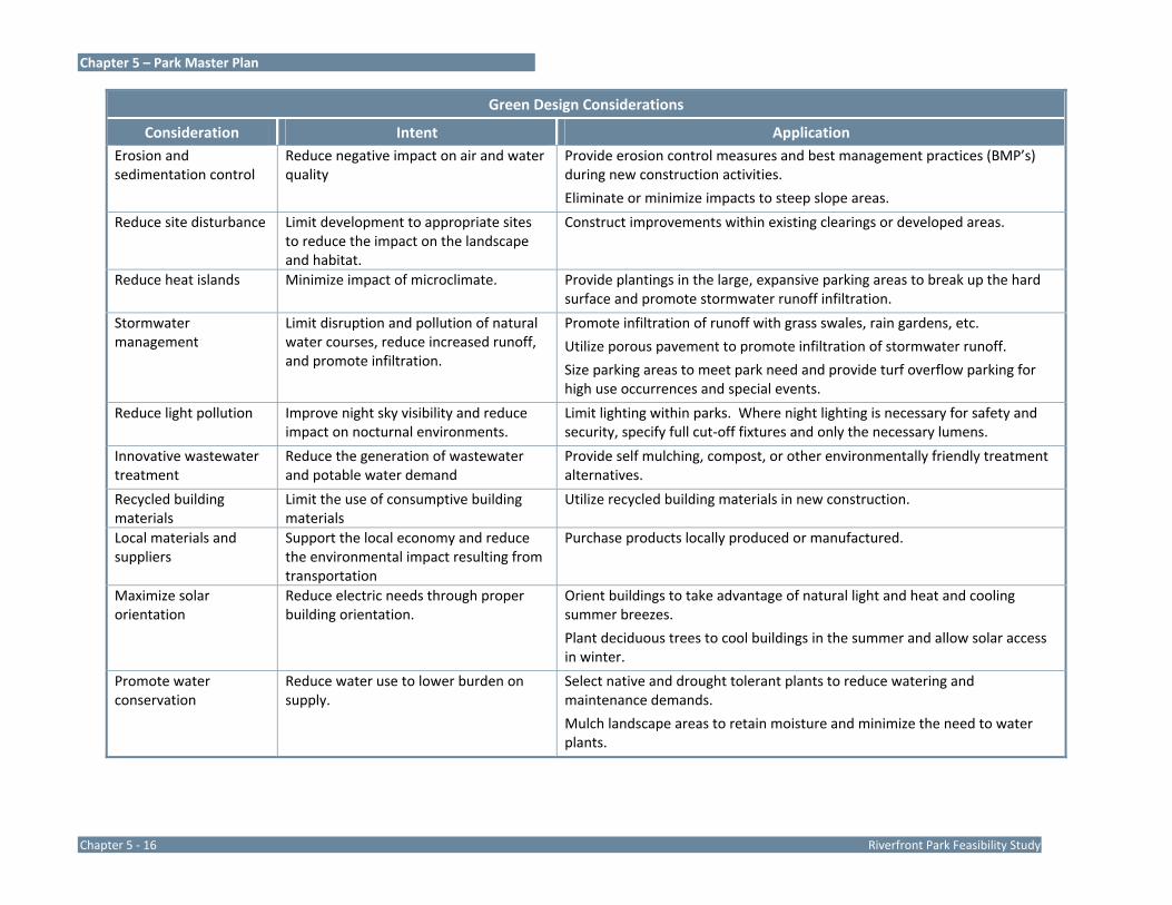
Chapter 5 – Park Master Plan
Chapter 5 ‐ 16 Riverfront Park Feasibility Study
Green Design Considerations
Consideration Intent Application Erosion and sedimentation control
Reduce negative impact on air and water quality
Provide erosion control measures and best management practices (BMP’s) during new construction activities.
Eliminate or minimize impacts to steep slope areas.
Reduce site disturbance Limit development to appropriate sites to reduce the impact on the landscape and habitat.
Construct improvements within existing clearings or developed areas.
Reduce heat islands Minimize impact of microclimate. Provide plantings in the large, expansive parking areas to break up the hard surface and promote stormwater runoff infiltration.
Stormwater management
Limit disruption and pollution of natural water courses, reduce increased runoff, and promote infiltration.
Promote infiltration of runoff with grass swales, rain gardens, etc.
Utilize porous pavement to promote infiltration of stormwater runoff.
Size parking areas to meet park need and provide turf overflow parking for high use occurrences and special events.
Reduce light pollution Improve night sky visibility and reduce impact on nocturnal environments.
Limit lighting within parks. Where night lighting is necessary for safety and security, specify full cut‐off fixtures and only the necessary lumens.
Innovative wastewater treatment
Reduce the generation of wastewater and potable water demand
Provide self mulching, compost, or other environmentally friendly treatment alternatives.
Recycled building materials
Limit the use of consumptive building materials
Utilize recycled building materials in new construction.
Local materials and suppliers
Support the local economy and reduce the environmental impact resulting from transportation
Purchase products locally produced or manufactured.
Maximize solar orientation
Reduce electric needs through proper building orientation.
Orient buildings to take advantage of natural light and heat and cooling summer breezes.
Plant deciduous trees to cool buildings in the summer and allow solar access in winter.
Promote water conservation
Reduce water use to lower burden on supply.
Select native and drought tolerant plants to reduce watering and maintenance demands.
Mulch landscape areas to retain moisture and minimize the need to water plants.

Chapter 5 – Park Master Plan
Riverfront Park Feasibility Study Chapter 5 ‐ 17
Green Design Considerations, continued
Consideration Intent Application Energy consumption Minimize use of fossil fuels. Install a ground source geothermal heat pump system for heating and
cooling of buildings.
Connect park sites to regional trail systems so that non‐motorized transportation modes can be used to access the site.
Install solar powered amenities/features (lights, electric outlets, well power. Use of solar power also eliminates the need for electric trenches and distribution system.
Use water efficiently Maximize water collection to reduce burden on supply.
Collect rainwater and runoff in rain barrels for watering landscaping and maintenance needs.
Direct rainwater to rain gardens to promote groundwater recharge.
Use high efficiency fixtures and composting toilets to reduce demand.
Use re‐circulating and water treatment systems for splash pads and spray features.
Emphasize and promote recycling
Reduce the amount of new materials required and lower the demand for new materials to be produced.
Reuse existing buildings, materials, and infrastructure.
Build with salvaged materials whenever available,
Participate in LEED and Sustainable Sites Initiative
Maximize the use of green solutions, strategies, and materials.
Use the LEED and Sustainable Sites Initiative project checklists for all aspects of design.

Chapter 5 – Park Master Plan
Chapter 5 ‐ 18 Riverfront Park Feasibility Study

Chapter 5 – Park Master Plan
Riverfront Park Feasibility Study Chapter 5 ‐ 19


Chapter 6 Cost & Implementation Analysis


Chapter 6 – Cost & Implementation Analysis
Riverfront Park Feasibility Study Chapter 6 - 1
Park Improvement Phasing
Achieving the vision presented in the master plan for Riverfront Park will require significant capital expenditures and dedication of Borough staff. As with most government investment in recreation facilities, the investment will occur in phases over several years. To guide the rehabilitation and improvements to Riverfront Park, cost estimates have been prepared to correspond to the various phases of development as determined by the Study Committee. The following summarizes the development sequence rationale and defines the phases for park development:
The river is the compelling attraction of the park and the recent vegetation clearing has been positively received by the community. Riverfront improvements should be the first phase to build upon this renewed interest in the riverfront. Additionally, as a destination along the Susquehanna River Greenway and Lower Susquehanna River Water Trail, riverfront improvements were viewed as having high potential for grant funding. This first phase has been separated into two phases (Phase 1A and 1B) to prioritize a realistic and achievable initial phase of construction.
The second phase should make the park more convenient to use and introduce more visitors to the park. Improving the central parking and providing a restroom will enhance the usability of the park. Developing the amphitheater will allow programming in the park like movie nights and concerts that will draw visitors that may have never visited the park before.
The remaining areas of the park should be developed in multiple phases and prioritized based on the funding mechanism. One phase would include all of the improvements on the Municipal Authority lands. A stand‐alone phase would include improvements associated with Front Street. Another stand alone phase would construct the pedestrian bridge on the
existing bridge pier remnant north of the Route 462 bridge. The remaining phase would provide the playground area, teen area and river picnic area.
The development on Water Street was viewed as a Borough redevelopment project and not included in the park improvement plan or cost estimates.
Suggested development phases:
- Phase 1A – The trail along the river edge, stabilized fishing access areas, and the seasonal docks.
- Phase 1B – The canal enhancements including lock weir enhancements, pond aeration and Maple Street crossing.
- Phase 2 –Redevelop the Maple Street parking area and boat turn‐around/drop‐off, the amphitheater, hillside seat walls, the restroom near the parking, and trails to access these facilities.
- Phase 3 – The new playground area, teen area and river picnic area and Lemon Street parking area.
- Phase 4 – The open lawn/special events area on the Municipal Authority land.
- Phase 5 – The pier on the stone bridge support, and connecting trail north of the Route 462 bridge.
- The Front Street Improvements ‐ Back‐in angle parking, intersection bulb‐outs, cross walks, street tree planting, and decorative wall.

Chapter 6 – Cost & Implementation Analysis
Chapter 6 - 2 Riverfront Park Feasibility Study
Early Implementation Projects
The vision created by the master plan will not happen immediately. Most often parks are developed in phases over time as grant funding becomes available. To sustain the excitement for park improvements that this planning process has generated, small project should be undertaken to create momentum for the entire project. These small improvements will show progress and provide enhancements that will immediately benefit citizens. Potential early implementation projects that can occur immediately, without significant investment or the need for extensive design, engineering, and permitting include:
Trail clearing and development (potential volunteer or State Corrections crew project).
Vegetation enhancements (riparian buffer, re‐forestation, wetlands buffers/planting, potential volunteer project).
Vegetation clearing at scenic views to river and view from upland area to teen area (potential volunteer project).
Interpretative signs/information kiosk/other park signs.
Probable Construction Cost Opinions
All costs provided in this plan are estimated based on the findings of this master plan and knowledge of similar park development. The proposed phases are based on logical sequence of construction and park function. These phases should be viewed as recommendations for development phasing. As funding becomes available or needs change in the Borough, the sequence of development may change. Not included in the cost estimates is an escalation cost between phases so that each phase can be compared and evaluated on an equal basis. As the park is developed, consideration should be given to escalation costs over the base cost provided herein. Design and
engineering fees have been estimated and are included in the cost breakdowns.
The following opinions of probable construction costs have been completed using DCNR format for use in future grant‐funding applications. Costs are based on Pennsylvania prevailing wages for year 2011 construction. A fifteen‐percent contingency is included in each cost opinion. No increase or adjustments for inflation has been accounted for between phases. A phasing plan is provided on page 5, followed by the detailed construction cost opinions.
Riverfront Park Probable Construction Cost Opinions
Phase 1A $301,357 Phase 1B $288,416 Phase 2 $884,313 Phase 3 $1,569,353 Phase 4 $581,003 Phase 5 $1,113,889 TOTAL $4,738,331
Front Street Improvements
$1,031,207
Construction Cost Opinion Assumptions and Exclusions
The Construction Cost Opinions on the following pages exclude the following items:
Utility service connection fees
Electric service upgrades or distribution
Utility relocation
Excavation or removal of rock or unsuitable materials
Remediation of soils and sinkholes.
Soil amendments
Import of topsoil

Chapter 6 – Cost & Implementation Analysis
Riverfront Park Feasibility Study Chapter 6 - 3
Riverbank stabilization
Improvements to Water and Lemon Streets
Construction of new buildings on Water Street
Demolition of the Municipal Authority block building
Construction management
Construction inspections fees
Dumping/hauling fees
Interpretive signage message and graphic design
Off‐site improvements and off‐site engineering
YSM is not a construction contractor and therefore probable constructions cost opinions are based solely upon our experience with construction. This requires YSM to make a number of assumptions as to actual conditions which will be encountered on the site; the specific decisions of other design professionals engaged; the means and methods of construction the contractor will employ; contractors' techniques in determining prices and market conditions at the time, and other factors over which YSM has no control. Additionally, the master plans were prepared using GIS mapping information and topographic and boundary line survey information was not available. GIS information is generalized and suitable for planning purposes but does not provide mapping that can be accurately measured for quantity take‐offs. Assumptions were made based on our visits to the site and the review of available information. Stormwater management and erosion and sedimentation control costs are provided on a per acre cost and specific strategies for this work can not be defined until the design and engineering phase.
Implementation Tasks
The development of Riverfront Park as depicted on the final master plan will require additional planning, design, and approvals. The
following list outlines the implementation tasks that may be required for renovation and development of Riverfront Park. This list is provided for planning purposes and should not be considered all inclusive as additional tasks, approvals, and permits may be required.
Secure Safe Harbor Water Power Corporation approval for improvement to the park property.
Secure Wrightsville Borough Municipal Authority approval for improvement to their property.
Secure Donsco approval for improvements on their property.
Secure Susquehanna River Basin Commission approval for work affecting the river.
Apply for park development funding grants.
Complete topographic survey.
Complete wetlands delineation.
Secure an access easement for trail development on the Donsco property.
Complete Phase 1 archeological studies, as appropriate, to determine that there are no archeological or historic artifacts of significance in the project area.
Develop construction documents. Construction documents will design in detail and engineer the proposed improvements and associated amenities. Prepare a project manual including technical and bidding specifications.
Prior to bidding and construction, obtain approvals from the various governing agencies. The following is a listing of typical approvals but may not be all‐inclusive.
- Municipal and County approval for land development plans, if required.

Chapter 6 – Cost & Implementation Analysis
Chapter 6 - 4 Riverfront Park Feasibility Study
- York County Conservation District approval for erosion and sedimentation control plans and NPDES Permit.
- Pennsylvania Department of Environmental Protection approval for any work within the waters of the Commonwealth including delineated wetlands and river and stream encroachments.
- Pennsylvania Department of Transportation approval for improvements within the Front Street right‐of‐way.
- US Environmental Protection Agency approval for redevelopment of the former Electro‐Platers of York land (Municipal Authority land).
- Pennsylvania Fish & Boat Commission approval for improvements to the Maple Street river access area and associated parking and other improvements to the lease area.
- Pennsylvania Department of Environmental Protection for sewage planning module approval.
- Pennsylvania One Call. Pennsylvania law requires three working days notice for construction phase and ten working days in design stage.
- Approval from public utilities required for development such as electric service extensions.
Each of the above permits and approval are typically involved and will require advance planning to facilitate the process. Adequate preparation and review time should be allotted. Upon approval of all required approvals and permits and completion of the construction documents, the project should be publicly bid for construction.

Chapter 6 – Cost & Implementation Analysis
Riverfront Park Feasibility Study Chapter 6 - 5
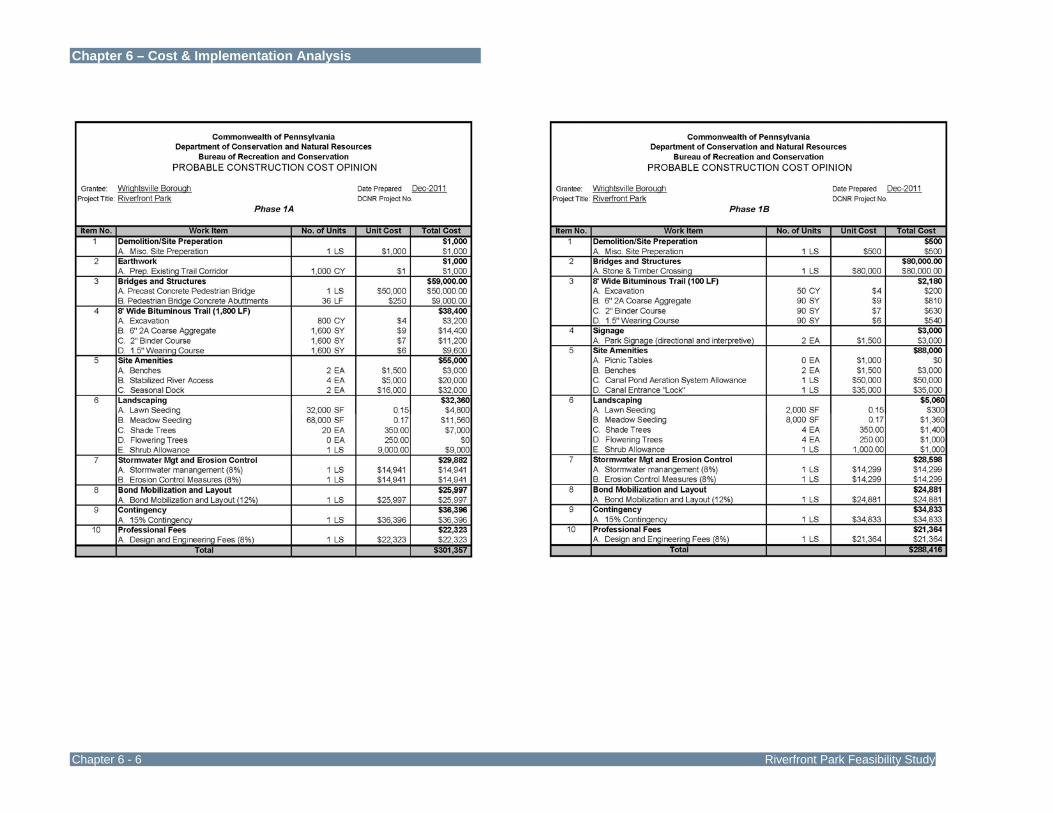
Chapter 6 – Cost & Implementation Analysis
Chapter 6 - 6 Riverfront Park Feasibility Study
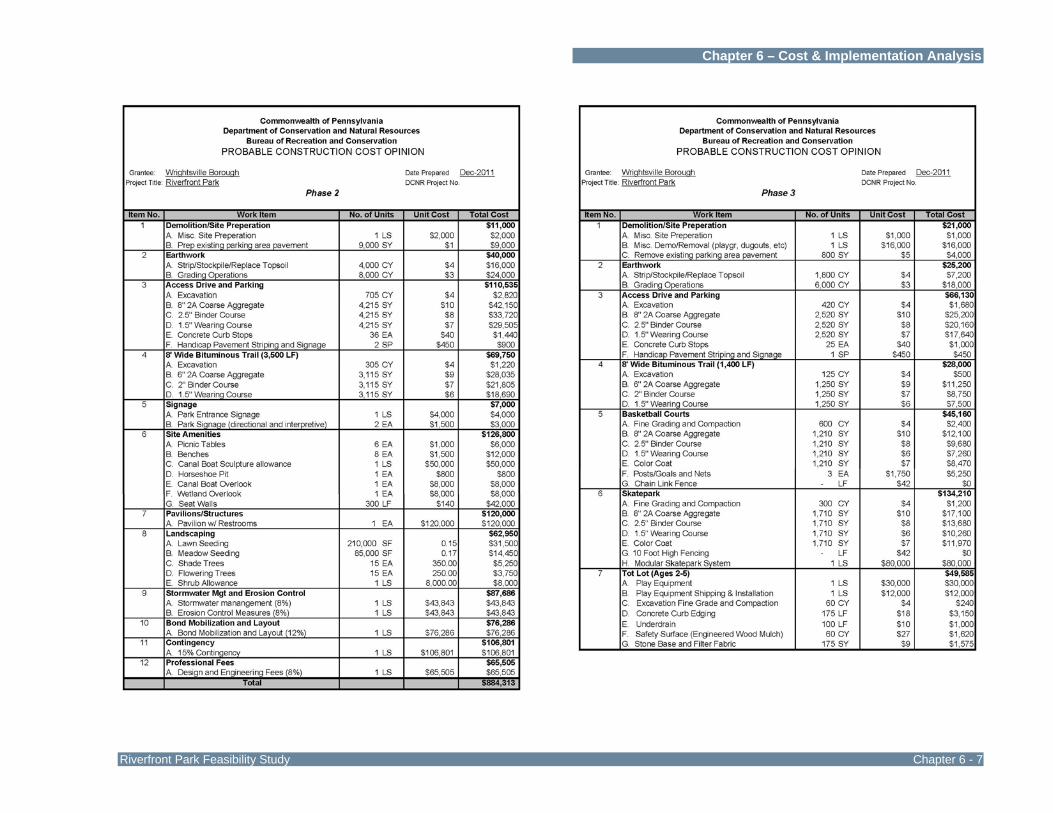
Chapter 6 – Cost & Implementation Analysis
Riverfront Park Feasibility Study Chapter 6 - 7

Chapter 6 – Cost & Implementation Analysis
Chapter 6 - 8 Riverfront Park Feasibility Study

Chapter 6 – Cost & Implementation Analysis
Riverfront Park Feasibility Study Chapter 6 - 9


Chapter 7 Operations & Financing

Chapter 7 – Operations and Financing
Riverfront Park Feasibility Study Chapter 7 ‐ 1
Riverfront Park Operations and Budget
The operations and maintenance of Riverfront Park has been assumed by Wrightsville Borough as the primary lessee of the 16.7 acre property. While Safe Harbor Water Power Corporation owns the site, the Borough undertakes the day to day operations and maintenance tasks. The tasks are necessitated by the requirements of the lease agreement and carried out as a public service for the benefit of residents and visitors who use Riverfront Park.
Wrightsville Borough has demonstrated that it recognizes the tremendous value parks and recreation facilities provides to the community by completing this master plan for Riverfront Park. Planning for the maintenance and management of Riverfront Park during this master plan process will better insure that Wrightsville Borough’s capital investment in park facilities and amenities is protected for use by its current and future residents.
Operations and maintenance is an essential element of the overall planning process for the park. To successfully manage the new park, the Borough must not only budget to expend funds for park design and construction, but also for operations and maintenance. Operations and maintenance funds are continuing expenses and must be budgeted and allocated from the Borough’s General Fund.
Administration
Administration and management oversight of the park will initially require only minor changes from the current staff responsibilities and practices. However, because of the added facilities and corresponding increase in use, these duties will evolve over time. The Borough staff will continue to handle all park reservations and act as a clearing house for all activity in the park to avoid the variety of conflicts that may occur because of expanded park use. Ideally
the Recreation Board should expand their current focus to include efforts to attract volunteers, partners and sponsors for the purpose of offering a variety of recreation programs in the park. If the Recreation Board does not initially take on this new role, then the Borough staff or a special committee appointed by the Borough will need to temporarily assume these responsibilities to promote recreation programming. Public Works will continue to oversee the entire maintenance program and the Police Department will oversee the security program.
The Borough should begin marketing the new park starting as early as the beginning of construction to help build excitement in the community for its Grand Opening. This can be done by adding information to the Borough website and other publications that the Borough distributes.
Recreation Activities
This planning process is designed to determine how the planned park facilities provide for passive and active recreation, enhance opportunities for community partnerships and generate revenues to help offset a portion of the annual operating costs.
Given the fiscal condition of all Pennsylvania municipalities and the limited Borough staff, it is not realistic to expect that the Borough will sponsor a large number of recreation programs at the park.
The majority of the recreational uses for Riverfront Park are anticipated to be passive rather than active and focused on unstructured, self‐directed recreation experiences such as river access for boating and fishing, walking on a trail, nature watching, enjoying the playground, using the skate park and picnicking.
The park design includes two boat launch areas; five picnic pavilions; paved walking paths; an amphitheater; open lawn areas; restrooms; vehicle and trailer parking areas; river piers, boating and

Chapter 7 – Operations and Financing
Chapter 7 ‐ 2 Riverfront Park Feasibility Study
fishing docks, scenic and wetlands overlooks; interpretive signage; tot and youth play equipment areas; skate park; basketball courts; lawn volleyball court; and horseshoe pits.
Listed below are some low or no cost structured and unstructured recreation opportunities possible at this park:
The daily usage of the park will be primarily by people desiring to access the river to enjoying boating, kayaking, canoeing and fishing. The park is along the water trail which will provide the opportunity for those already on the water to stop and enjoy the park facilities.
Canoe and kayak lessons, boater and water safety courses for beginner and experienced boaters could be offered by a non‐profit agency, the Fish and Boat Commission or a local outfitter.
Group outings will be accommodated in the new picnic pavilions. Support amenities such as the open lawn, lawn volleyball, basketball courts, horseshoe pits and play areas will make the experience more enjoyable and marketable.
Riverfront Park will offer opportunities for healthy lifestyle activities. The park’s pathways will give people safe and attractive places to walk and jog as well as provide the opportunity for nature study such as birding. Dog walking will also be a popular activity.
Special family events such as movie nights, an egg hunt and a fall festival with hay rides and pumpkin painting could be organized by the Recreation Board or other local non‐profits and civic organizations.
The amphitheater could accommodate a variety of performances from May through September such as summer concerts, talent shows, recitals, and other community events which can be organized and conducted
by local organizations or the Recreation Board with support from sponsors. The School District could feature their music program by having its high school band play a lunchtime concert in May or early June.
The park will provide an excellent classroom for the study of nature, the environment and ecology as well as the experience of just being outdoors. Nature and ecology programs could be planned by the School District as part of its required curriculum to help students understand in a real setting how their everyday lives revolve around the natural world and the resources it provides. Star Parties to explore the night sky could be sponsored and conducted by an astronomical club.
Maintenance
The lease agreement between Safe Harbor Water Power Corporation and Wrightsville Borough stipulates that the Borough will maintain the property as summarized on Chapter 3, page 5.
The amount of maintenance required at a park is very much related to design, construction, intensity of use, type of activities, the age of facilities and community expectations. The development of Riverfront Park will require the Public Works Department to adjust its current maintenance practices to provide the appropriate level of care for this new capital investment. The Borough will have to insure that the Public Works staff receives the additional resources needed to adequately care for this new public park. Maintenance is the single largest recurring expenditure in parks and recreation operations. Over the lifetime of a park, about 75 percent of its cost is in maintenance while only about 25 percent is in acquisition, design and construction.

Chapter 7 – Operations and Financing
Riverfront Park Feasibility Study Chapter 7 ‐ 3
Maintenance and safety are synonymous because parks are can only remain safe and useable when a quality maintenance and inspection program is in place. An informal inspection of the park should be completed by the Public Works staff each time that they visit the park to identify hazards as well as other issues that need to be addressed. Minor issues should be resolved immediately provided the staff has the needed tools, equipment and materials to complete the repair. Some issues will require later scheduling of work, perhaps closing access to facilities or equipment that pose a serious hazard, and notification of the Police Department.
Listed below are general strategies that will better insure that the newly constructed facilities will be properly maintained for the enjoyment of Borough citizens and visitors.
1. The Borough should annually provide an appropriate number of knowledgeable staff, contractors and volunteers who are equipped with the necessary tools, equipment, materials and supplies needed to maintain the park in a safe, useable and attractive condition.
2. The Borough should continually evaluate and update its maintenance standards and processes to adjust the maintenance program to meet the need of the community. Standards for each park facility from the horseshoe pits to the boat launch areas should be established in a manner that describes what that facility “looks like” when the maintenance service is completed. The maintenance levels recommended in this operations and management plan are the minimum that should be considered by the Borough as needed to manage and maintain the park.
3. The Borough should collect data and track maintenance and inspections to know how efficiently and effectively the maintenance program is working, manage risk, and identify opportunities for improvements.
4. The Borough’s maintenance plan should emphasize preventative, routine and scheduled maintenance rather than reacting to crisis management. A proactive approach to maintenance not only saves time and money, but it results in a consistently higher quality experience for park visitors.
5. The Borough should closely coordinate the maintenance and use of the park to manage it in keeping with the site’s purpose.
6. The Public Works Department should notify the Police Department immediately when acts of vandalism are discovered and then correct the effects of vandalism within 24 hours or as soon as possible after learning about an incident.
Recommended Minimum Level of Maintenance
Lawn Care – Mowing is the most basic and time consuming of all turf maintenance activities. The main reasons to mow grass are to maintain an aesthetically pleasing appearance and to produce a surface that will support a variety of activities. At a minimum, turf at the park should be mowed weekly at three to three and a half inches. In an effort to maintain turf coverage, bare spots should be promptly reseeded throughout the growing season with perennial ryegrass.
Depending on the intensity of use in the open lawn areas, the turf may require more maintenance and certainly greater user management to provide a safe, consistent surface that accommodates the needs of users without experiencing any significant turf loss. Ideally the lawn areas should begin each season with one hundred percent (100%) turf coverage. Listed below are additional practices that may be needed to maintain a healthy lawn throughout the season. The need to implement these practices is dependent on the intensity of use in the lawn areas. The lawn volleyball court area would greatly benefit from these practices.
Chapter 7 – Operations and Financing
Chapter 7 ‐ 4 Riverfront Park Feasibility Study
Additional Turf Maintenance
Fertilize in the spring and Fall with a granular slow release nitrogen fertilizer in a formula indicated by a soil test. Also, apply limestone if indicated by the soil test.
Apply herbicides, disease and insect control to problematic areas when noticeable significant damage occurs.
Aerate the lawn areas by using a core aerator crossing the sites in different directions from two to four times in the spring and/or fall. Immediately after aerating break up and spread the cores with a drag mat or chain drag. Increase the frequency of aeration as needed to reduce compaction and maintain healthy turf.
Over‐seed large areas using a slit‐seeder with a mixture of perennial ryegrass and bluegrass after aeration.
Meadow Care – The entire site except for the wooded or wetland areas does not have to be maintained in lawn. Meadows using hardy native grasses and plants offer a low maintenance alternative to high maintenance turf. Meadows can be used anywhere not planned for activity to add interest, improve wildlife habitat and enhance storm water management practices.
An annual fall mowing of the meadow areas is recommended to help control a variety of invasive and undesirable woody plants from taking over the site. Periodic hand pruning and targeted herbicide spraying will likely be needed to control unwanted vegetation throughout the growing season.
Trash and Litter Control – Trash and recycling collection can become a time‐consuming task. The Borough may wish to adopt an alternative program that eliminates the requirement for routine year‐round trash collection. This alternative to the weekly collection is a “carry in, carry out” policy, which not only eliminates the need to place disposal containers in the park but more importantly
eliminates a routine maintenance task. The adoption of such a program will only be successful with the ongoing education of park users and staff through the placement of signage and other promotional materials about this program.
In the event that trash and recycling collection is preferred, a weekly collection schedule with additional visits based on pavilion rentals and other organized activities should be implemented. The collection frequency should be adjusted throughout the year with the goal to avoid containers from ever overflowing using the least amount of staff time.
Storm Debris Removal – Because Riverfront Park is in the floodplain and subject to periodic flooding, it is important that the Borough react quickly after waters subside to return the park to a safe and useable condition. Work includes removal of debris deposited by flood waters, cleaning and repairing facilities as needed.
Roads, Parking and Boat Launch Areas – These areas should be vacuum swept at least three times annually. Parking line striping should be renewed every two to four years. The Borough needs to adopt a snow removal policy that describes what areas will be cleared in the park and when this is done in relation to the Borough’s snow removal plan.
Restrooms and Pavilions – Pavilions should be swept and tables cleaned as needed throughout the period from April through October at least weekly. The Borough should consider requiring that groups who reserve pavilions sweep the pavilion floor and clean tables as part of their rental obligation. The annual repair and maintenance of all movable picnic tables should take place during the winter months if a suitable indoor storage and workspace is available. Restrooms should be cleaned anywhere from two to five days per week during peak use periods and at least weekly at other times of the year. Like trash and recycling collection, the goal is to maintain the restrooms using the least number of staff hours to achieve the desired results.

Chapter 7 – Operations and Financing
Riverfront Park Feasibility Study Chapter 7 ‐ 5
Trees, Shrubs and Landscape Plantings – The need for tree trimming should be determined annually and the work scheduled or contracted as needed. Shrubs should be trimmed annually according to plant requirements. Landscaped beds should be prepared in the spring and weeded throughout the season from April through October to maintain an attractive appearance. Landscaped areas should be mulched with four inches of material in the fall, to save time in the spring when many other activities are required.
Because of the limited resources available to provide the intense maintenance required for landscaped beds, let alone the time needed to enhance them with annual color, the Borough should actively seek partners who would assume care for these areas. Good candidates for this type of partnership are local garden clubs or environmental committees of local civic clubs. Applications to combat disease or insect damage should be completed only when serious damage is evident.
Play Equipment and Skate Park Areas – Play equipment and installation that meets the safety criteria of the Consumer Product Safety Commission and the American Society of Testing and Materials Guidelines for Public Playground Safety is only the first step to ensuring a safe play environment. A regular play equipment and skate park area maintenance and inspection program will help the Borough provides a safe and useable environment. Equipment inspections should be completed at the park weekly during peak season and monthly during other times of the year. Inspections should follow a simple checklist to insure consistency in the inspection as well as the inspection recording. Any deficiency found should be corrected immediately if the staff person has the capability to perform the work or it needs to be scheduled for prompt resolution. An inspection program will work best if the same staff member is responsible for the inspection each time. The staff member becomes very familiar with the site’s equipment and is able to efficiently complete the inspection.
The equipment area surfacing needs to be kept free from all debris including grass and leaves. The equipment and surfacing should also be washed at the beginning of each spring and then on an as needed basis.
Trails – The hard‐surfaced pedestrian pathways should be kept free from all debris and leaves. Trails should be maintained with overhead clearance from all vegetation of at least eight feet and wherever possible, should also have side clearance of at least two to six feet. These asphalt and concrete walks should be repaired anytime a depression of one inch or crack of one‐half inch or more occurs in the surface.
The Borough should consider whether to clear snow and ice from part of the park trail network in order to provide year‐round opportunities for people to enjoy walking, jogging and nature watching. If the Borough desires to clear some trails then the route must be selected and the mechanical equipment needed to clear snow and ice from the trail provided. A small maintenance vehicle or a trailer equipped with a plow and snow blower would be able to perform clearing. Conventional ice melt products such as salt or calcium chloride should be avoided in the park because of their adverse effect on plant life. “Green” ice melt alternatives such as calcium magnesium acetate or coated urea should be considered.
Amphitheater, Pedestrian Boardwalks, Viewing Decks, Docks, Sculptures and Signage – A thorough annual inspection of all facility structures including their support beams, pilings, footings, decking, posts and abutments is needed early each spring. These facilities should be cleaned with eco friendly products and scheduled for repairs as needed with a goal for completion by mid‐May. Maintenance should be scheduled based on the inspection report and the manufacturer’s recommendations for the construction materials used. The use of “green” low maintenance materials during construction, such as recycled lumber, may be more expensive but will save money with lower maintenance costs
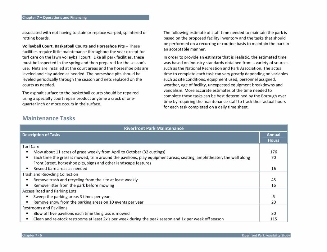
Chapter 7 – Operations and Financing
Chapter 7 ‐ 6 Riverfront Park Feasibility Study
associated with not having to stain or replace warped, splintered or rotting boards.
Volleyball Court, Basketball Courts and Horseshoe Pits – These facilities require little maintenance throughout the year except for turf care on the lawn volleyball court. Like all park facilities, these must be inspected in the spring and then prepared for the season’s use. Nets are installed at the court areas and the horseshoe pits are leveled and clay added as needed. The horseshoe pits should be leveled periodically through the season and nets replaced on the courts as needed.
The asphalt surface to the basketball courts should be repaired using a specialty court repair product anytime a crack of one‐quarter inch or more occurs in the surface.
Maintenance Tasks
The following estimate of staff time needed to maintain the park is based on the proposed facility inventory and the tasks that should be performed on a recurring or routine basis to maintain the park in an acceptable manner.
In order to provide an estimate that is realistic, the estimated time was based on industry standards obtained from a variety of sources such as the National Recreation and Park Association. The actual time to complete each task can vary greatly depending on variables such as site conditions, equipment used, personnel assigned, weather, age of facility, unexpected equipment breakdowns and vandalism. More accurate estimates of the time needed to complete these tasks can be best determined by the Borough over time by requiring the maintenance staff to track their actual hours for each task completed on a daily time sheet.
Riverfront Park Maintenance Description of Tasks Annual
Hours Turf Care
Mow about 11 acres of grass weekly from April to October (32 cuttings) Each time the grass is mowed, trim around the pavilions, play equipment areas, seating, amphitheater, the wall along
Front Street, horseshoe pits, signs and other landscape features Reseed bare areas as needed
176 70
16 Trash and Recycling Collection
Remove trash and recycling from the site at least weekly Remove litter from the park before mowing
45 16
Access Road and Parking Lots Sweep the parking areas 3 times per year Remove snow from the parking areas on 10 events per year
6 20
Restrooms and Pavilions Blow off five pavilions each time the grass is mowed Clean and re‐stock restrooms at least 2x’s per week during the peak season and 1x per week off season
30 115
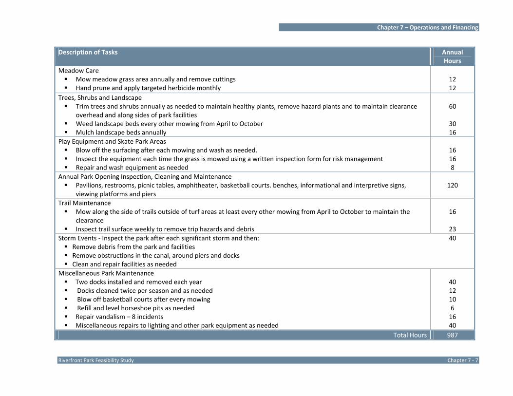
Chapter 7 – Operations and Financing
Riverfront Park Feasibility Study Chapter 7 ‐ 7
Description of Tasks Annual Hours
Meadow Care Mow meadow grass area annually and remove cuttings Hand prune and apply targeted herbicide monthly
12 12
Trees, Shrubs and Landscape Trim trees and shrubs annually as needed to maintain healthy plants, remove hazard plants and to maintain clearance
overhead and along sides of park facilities Weed landscape beds every other mowing from April to October Mulch landscape beds annually
60
30 16
Play Equipment and Skate Park Areas Blow off the surfacing after each mowing and wash as needed. Inspect the equipment each time the grass is mowed using a written inspection form for risk management Repair and wash equipment as needed
16 16 8
Annual Park Opening Inspection, Cleaning and Maintenance Pavilions, restrooms, picnic tables, amphitheater, basketball courts. benches, informational and interpretive signs,
viewing platforms and piers
120
Trail Maintenance Mow along the side of trails outside of turf areas at least every other mowing from April to October to maintain the
clearance Inspect trail surface weekly to remove trip hazards and debris
16
23 Storm Events ‐ Inspect the park after each significant storm and then:
Remove debris from the park and facilities Remove obstructions in the canal, around piers and docks Clean and repair facilities as needed
40
Miscellaneous Park Maintenance Two docks installed and removed each year Docks cleaned twice per season and as needed Blow off basketball courts after every mowing Refill and level horseshoe pits as needed Repair vandalism – 8 incidents Miscellaneous repairs to lighting and other park equipment as needed
40 12 10 6 16 40
Total Hours 987

Chapter 7 – Operations and Financing
Chapter 7 ‐ 8 Riverfront Park Feasibility Study
Park Maintenance Calendar
A maintenance calendar is another useful tool for the administration of the overall park maintenance program. The calendar included below quickly depicts the major tasks that are
needed to successfully maintain the park, the frequency that the task is completed, and when the work is scheduled.
A. Misc. Park Maintenance Frequency Jan Feb Mar Apr May Jun Jul Aug Sept Oct Nov Dec
Annual Park Inspection & Clean up
Annual X X
Leaf Removal Annual X X
Snow Removal As needed X X X X
Storm ‐ Inspection & Clean up & Repair
As needed X X X X X X X X X X X X
Trash / Litter Control Weekly X X X X X X X X X X X X
Weed Control As needed X X X X X
Meadow Mowing Annual X
Herbicide Application Annual X
Vandalism Repair (report to Police Dept.)
ASAP X X X X X X X X X X X X
Graffiti Removal (report to Police Dept.)
24 hours X X X X X X X X X X X X
B. Park Equipment Frequency Jan Feb Mar Apr May Jun Jul Aug Sept Oct Nov Dec
Benches – portable Put out / Bring in
Annual X X
Benches – portable Repair & paint/stain as needed
Annual X X X
Benches –outdoor Inspect / repair
Annual X X
Benches –outdoor Paint / stain
As needed X X
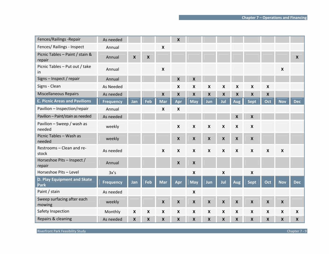
Chapter 7 – Operations and Financing
Riverfront Park Feasibility Study Chapter 7 ‐ 9
Fences/Railings ‐Repair As needed X
Fences/ Railings ‐ Inspect Annual X
Picnic Tables – Paint / stain & repair
Annual X X X
Picnic Tables – Put out / take in
Annual X X
Signs – Inspect / repair Annual X X
Signs ‐ Clean As Needed X X X X X X X
Miscellaneous Repairs As needed X X X X X X X X
C. Picnic Areas and Pavilions Frequency Jan Feb Mar Apr May Jun Jul Aug Sept Oct Nov Dec
Pavilion – Inspection/repair Annual X X
Pavilion – Paint/stain as needed As needed X X
Pavilion – Sweep / wash as needed
weekly X X X X X X
Picnic Tables – Wash as needed
weekly X X X X X X
Restrooms – Clean and re‐stock
As needed X X X X X X X X X
Horseshoe Pits – Inspect / repair
Annual X X
Horseshoe Pits – Level 3x’s X X X
D. Play Equipment and Skate Park
Frequency Jan Feb Mar Apr May Jun Jul Aug Sept Oct Nov Dec
Paint / stain As needed X
Sweep surfacing after each mowing
weekly X X X X X X X X X
Safety Inspection Monthly X X X X X X X X X X X X
Repairs & cleaning As needed X X X X X X X X X X X X

Chapter 7 – Operations and Financing
Chapter 7 ‐ 10 Riverfront Park Feasibility Study
E. Boat Launch, Drives and Parking
Frequency Jan Feb Mar Apr May Jun Jul Aug Sept Oct Nov Dec
Inspect annual X
Paint lines As needed X X X
Repair As needed X X
Sweep pavement 3x’s / yr X X X
Snow Removal As needed X X X X
F. Trees, Shrubs, and Flowers Frequency Jan Feb Mar Apr May Jun Jul Aug Sept Oct Nov Dec
Mulch landscape areas Annual X X
Flower Beds ‐ Weed 2x’s / mo X X X X X X X
Flower Beds –annuals Plant / remove
Annual X X X
Shrubs – Trimming Annual X
Tree trimming/removal As needed X X X X X
G. Boat Docks Frequency Jan Feb Mar Apr May Jun Jul Aug Sept Oct Nov Dec
Put in / take out Annual X X
Inspect / repair Annual X X
Clean 3 x’s / year X X X
H. Courts Frequency Jan Feb Mar Apr May Jun Jul Aug Sept Oct Nov Dec
Inspect / repair Annual X X
Volleyball – install / remove net
Annual X X
Basketball – replace nets As Needed X X X X X X X
Basketball ‐ cleaning X X X X X X X
Volleyball – Turf Care See below
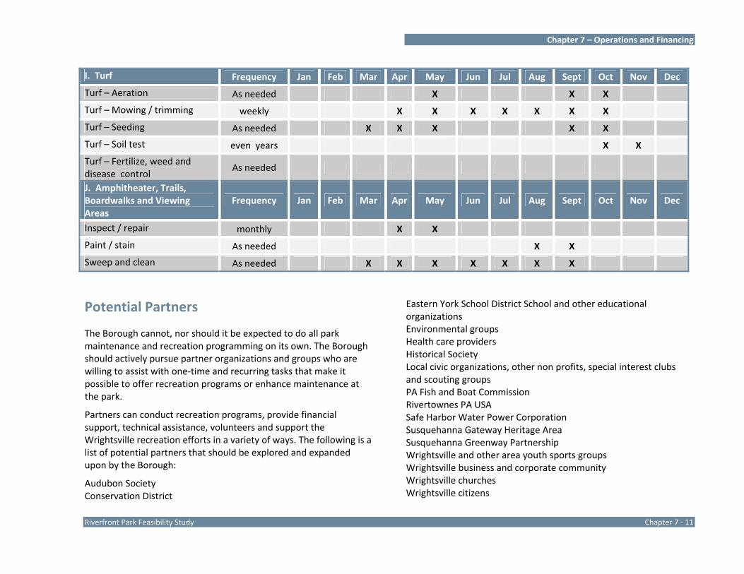
Chapter 7 – Operations and Financing
Riverfront Park Feasibility Study Chapter 7 ‐ 11
I. Turf Frequency Jan Feb Mar Apr May Jun Jul Aug Sept Oct Nov Dec
Turf – Aeration As needed X X X
Turf – Mowing / trimming weekly X X X X X X X
Turf – Seeding As needed X X X X X
Turf – Soil test even years X X
Turf – Fertilize, weed and disease control
As needed
J. Amphitheater, Trails, Boardwalks and Viewing Areas
Frequency Jan Feb Mar Apr May Jun Jul Aug Sept Oct Nov Dec
Inspect / repair monthly X X
Paint / stain As needed X X
Sweep and clean As needed X X X X X X X
Potential Partners
The Borough cannot, nor should it be expected to do all park maintenance and recreation programming on its own. The Borough should actively pursue partner organizations and groups who are willing to assist with one‐time and recurring tasks that make it possible to offer recreation programs or enhance maintenance at the park.
Partners can conduct recreation programs, provide financial support, technical assistance, volunteers and support the Wrightsville recreation efforts in a variety of ways. The following is a list of potential partners that should be explored and expanded upon by the Borough:
Audubon Society Conservation District
Eastern York School District School and other educational organizations Environmental groups Health care providers Historical Society Local civic organizations, other non profits, special interest clubs and scouting groups PA Fish and Boat Commission Rivertownes PA USA Safe Harbor Water Power Corporation Susquehanna Gateway Heritage Area Susquehanna Greenway Partnership Wrightsville and other area youth sports groups Wrightsville business and corporate community Wrightsville churches Wrightsville citizens
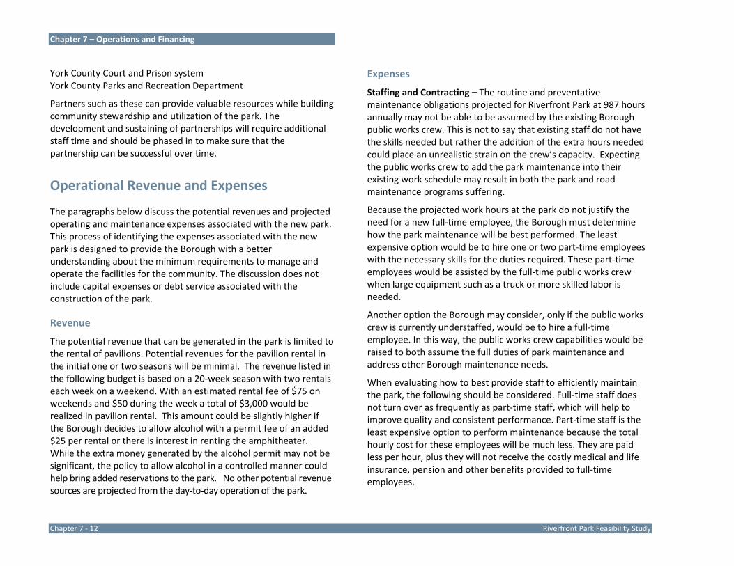
Chapter 7 – Operations and Financing
Chapter 7 ‐ 12 Riverfront Park Feasibility Study
York County Court and Prison system York County Parks and Recreation Department
Partners such as these can provide valuable resources while building community stewardship and utilization of the park. The development and sustaining of partnerships will require additional staff time and should be phased in to make sure that the partnership can be successful over time.
Operational Revenue and Expenses
The paragraphs below discuss the potential revenues and projected operating and maintenance expenses associated with the new park. This process of identifying the expenses associated with the new park is designed to provide the Borough with a better understanding about the minimum requirements to manage and operate the facilities for the community. The discussion does not include capital expenses or debt service associated with the construction of the park.
Revenue
The potential revenue that can be generated in the park is limited to the rental of pavilions. Potential revenues for the pavilion rental in the initial one or two seasons will be minimal. The revenue listed in the following budget is based on a 20‐week season with two rentals each week on a weekend. With an estimated rental fee of $75 on weekends and $50 during the week a total of $3,000 would be realized in pavilion rental. This amount could be slightly higher if the Borough decides to allow alcohol with a permit fee of an added $25 per rental or there is interest in renting the amphitheater. While the extra money generated by the alcohol permit may not be significant, the policy to allow alcohol in a controlled manner could help bring added reservations to the park. No other potential revenue sources are projected from the day‐to‐day operation of the park.
Expenses
Staffing and Contracting – The routine and preventative maintenance obligations projected for Riverfront Park at 987 hours annually may not be able to be assumed by the existing Borough public works crew. This is not to say that existing staff do not have the skills needed but rather the addition of the extra hours needed could place an unrealistic strain on the crew’s capacity. Expecting the public works crew to add the park maintenance into their existing work schedule may result in both the park and road maintenance programs suffering.
Because the projected work hours at the park do not justify the need for a new full‐time employee, the Borough must determine how the park maintenance will be best performed. The least expensive option would be to hire one or two part‐time employees with the necessary skills for the duties required. These part‐time employees would be assisted by the full‐time public works crew when large equipment such as a truck or more skilled labor is needed.
Another option the Borough may consider, only if the public works crew is currently understaffed, would be to hire a full‐time employee. In this way, the public works crew capabilities would be raised to both assume the full duties of park maintenance and address other Borough maintenance needs.
When evaluating how to best provide staff to efficiently maintain the park, the following should be considered. Full‐time staff does not turn over as frequently as part‐time staff, which will help to improve quality and consistent performance. Part‐time staff is the least expensive option to perform maintenance because the total hourly cost for these employees will be much less. They are paid less per hour, plus they will not receive the costly medical and life insurance, pension and other benefits provided to full‐time employees.

Chapter 7 – Operations and Financing
Riverfront Park Feasibility Study Chapter 7 ‐ 13
Regardless of the staffing option selected, the Borough will need to contract out some maintenance activity either because it does not have the equipment needed or the staff does not have the knowledge and certifications. Examples where the Borough must outsource work include enhanced turf maintenance duties such as fertilizing, aerating, slit seeding and herbicide application, and large tree trimming and removal. The Borough may also want to consider outsourcing some or all of the routine grass mowing depending on the staffing option selected. In some cases, outsourcing routine maintenance can be a cost effective staffing solution.
In addition to the staffing and contracting options, it is highly recommended that the Borough identify park maintenance duties that can be performed by volunteers, and actively solicit these needed individuals or groups. The current use of community service workers and prison inmates should also be continued.
Maintenance Supplies and Equipment – The park maintenance program will require the use of a variety of equipment such as a mower, string trimmer, chain saw, pressure washer, blower and cleaning supplies together with a variety of hand tools. If the majority of maintenance duties are being performed by part‐time staff, the basic equipment should be stored at the park. If the maintenance work is performed by full‐time staff with or without seasonal staff, storing equipment in the park is not critical.
The Borough will have to begin budgeting for the purchase of materials, supplies and utilities for park maintenance and operation. Examples of materials and supplies include: cleaning supplies, restroom supplies, mulch for landscape areas, grass seed, equipment fuel, landscape plantings, paint and stain. The cost of supplies will increase annually as park use increases and as the facility ages.
First‐Year Budget – Listed on the next page is a projection of first‐year operating expenses assuming that the entire park is
constructed at once and all work is performed by the full‐time Borough Public Works maintenance employees.
Periodic Maintenance and Capital Equipment Replacement – In addition to those regular maintenance duties that are required each year, there are other tasks that must be completed during the lifetime of any facility. These tasks deal with periodic maintenance such as painting and sealing and the normal replacement of minor and major equipment such as play equipment, park benches, picnic tables and mowers. The timing for these repairs and replacements is determined largely by the materials used, weather, use of the facility, and the maintenance performed during its life. Listed below are examples of such items without estimated costs. Costs are not estimated because the time frame is years away and an exercise in projecting these expenses would not be accurate.
Projected First‐Year Operating Income & Expense Riverfront Park
Description Total Revenue Pavilion Rentals $3,000
Description Total Expenses
Administration $0Recreation Supplies and Services $3,000Maintenance Labor: 987 hours @ $25 per hour (wages and fringes included)
$24,675
Contracted Maintenance Services $5,000Maintenance Supplies and Utilities $10,000
Total Expenses $42,675
Net Expense (Total Expense – Income) $39,675Notes: There is no cost included for the added insurance that will be needed because of the large investment in the park. Such an estimate should be requested from the Borough’s insurance broker.

Chapter 7 – Operations and Financing
Chapter 7 ‐ 14 Riverfront Park Feasibility Study
The American Public Works Association recommends budgeting two to four percent of the capital development costs annually to establish as a capital reserve account for the major capital repairs/replacements needed for a park. While this method of depreciating capital expenses is not a normal practice in Pennsylvania municipalities, it is something that Wrightsville Borough may want to consider.
Implementation Strategies for Funding the Development of Riverfront Park
A wide variety of financing tools and outside funding sources are available to Wrightsville Borough which can be directly targeted to helping to finance the development of the community park. The most successful strategies will involve pursuing multiple sources in combination. In this way, locally‐generated funds can be used to match funds such as grants from outside agencies. The Borough should consider working with a financial planning consultant to develop a financing plan for the development of the community park that includes a mix of public and private resources.
As previously discussed in Chapter 3, Riverfront Park is owned by Safe Harbor Water Power Corporation and leased to Wrightsville Borough and PA Fish and Boat Commission under relatively short term (10 year) leases. Safe Harbor Water Power Corporation has confirmed that they are not interested in selling the park property at this time or amending the leases to longer terms. The current 10‐year lease term is less than the minimum 25 year term lease PA Department of Conservation and Natural Resources (PA DCNR) requires for eligibility to apply for park development funding through the PA DCNR C2P2 Community Recreation and Conservation grant program. Wrightsville Borough must be the entity to seek funding through this program as Safe Harbor Water Power Corporation, as a private entity, is not eligible. The relatively short‐term lease between Wrightsville Borough and Safe Harbor Water Power Corporation makes the Borough ineligible for state funding through the PA DCNR C2P2 program as it currently exists. Not withstanding a special agreement, funding for the park development will be limited to sources other than PA DCNR.
Tax Support
The Borough could enact a dedicated recreation tax or allocate a portion of the property, earned income or real estate transfer taxes to help fund the development of the community park.
Bonds
Significant expenditures such as the development of Riverfront Park cannot be funded using only existing operating revenue and outside funding sources. The Borough can issue long‐term debt to finance large‐scale capital projects. Bonds are promissory notes that can provide the Borough with the funds and flexibility it needs up front to fund this large‐scale park development project. Long‐term bonds raise substantial amounts of money, enabling the community to build this important recreation facility now. The money, plus
Periodic Maintenance and Capital Equipment Replacement Item Time Frame Restriping Parking Lots 5 years Resealing Asphalt Areas 5 years Painting Pavilions, Play Area and Park Equipment
As needed Replacing Pavilions 20 years Repaving 15 plus years Replacing Playground Equipment 10‐15 years Replacing Park Furnishings 15 years Replace Mower 10 years

Chapter 7 – Operations and Financing
Riverfront Park Feasibility Study Chapter 7 ‐ 15
interest, is repaid to the bondholders over a specified time period. Since the costs are spread out over a long time horizon, they are borne by both current and future residents.
Bank Loans
Bank loans are almost as common a financing vehicle today as a bond issue. Many times, bank loans are more cost‐effective than bond issues when the maturity of the issue is less than 15 years and when the issue size is less than $10 million. Bank loans typically have shorter or no prepayment penalties, do not need a trustee/paying agent (the bank does this), and can be issued in less than $5,000 increments.
PennVest
PennVest financing could be a useful tool for the Borough when the rates offered are below normal market rates. PennVest’s goal is to work with the public sector and job creators to achieve both environmental improvements and economic development.
Grant Funding Programs
Dozens of grants are potentially available through a variety of public and private agencies at the county, state and federal levels to fund the development of the community park. These grants can provide excellent sources of funding throughout the year for projects ranging from tree planting and acquiring park equipment to funding a major phase of park construction.
The Rivers, Trails and Conservation Assistance Program (RTCA) is the community assistance arm of the National Park Service. RTCA supports community‐led natural resource conservation and outdoor recreation projects. RTCA staff provides technical assistance to communities so they can conserve rivers, preserve open space, and develop trails and greenways. RTCA works collaboratively, by invitation, with partners on a wide variety of conservation and
recreation projects. RTCA provides a variety of assistance tailored to the partner’s needs, but does not provide direct grants.
State Grants ‐ Pennsylvania has responded to decreasing federal support by establishing its own funding sources to provide financial assistance to municipalities for capital projects.
The Department of Conservation and Natural Resources (DCNR) makes grants available to municipalities to support all types of parks, recreation, greenways and trails and open space efforts.
DCNR Community Conservation Partnership Program (C2P2) – Park development grants typically do not exceed $150,000 to $250,000. Applications for development and construction grants are due in the spring of each year. A 50% match is required from the local project sponsor. (See previous discussion on page 14, above.)
DCNR Urban and Community Forestry Grants Program – This program encourages the planting of trees in communities. Challenge grants provide 50% of the cost of the purchase and delivery of trees. Requests for funds range from $1,500 to $5,500. Priority is given to those proposals which have an educational component tied to the grant and to first‐time applicants.
DCNR Peer‐to‐Peer Technical Assistance Grant Program – This program provides grants of up to 90% of eligible costs ($10,000 maximum) to study problem‐specific issues dealing with administration of parks and recreation facilities and/or services. These are short‐term projects conducted primarily by experienced park and recreation professionals who work closely with community leaders.
The Department of Community and Economic Development (DCED) supports projects that focus on economic development, travel and tourism, technical assistance and community development. A

Chapter 7 – Operations and Financing
Chapter 7 ‐ 16 Riverfront Park Feasibility Study
number of funding programs may be tapped for the community park project.
DCED Community Revitalization Program – This program funds local initiatives that improve the stability of communities and enhance local economic conditions. Funds may be used to construct or rehabilitate infrastructure, rehabilitate, acquire or demolish structures; revitalize or construct community facilities, purchase or upgrade machinery and equipment, develop plans for community assets, public safety, crime prevention, recreation or training; and acquire land, buildings and rights‐of‐way.
DCED Community and Municipal Facilities Assistance Program – These grants range from $5,000 to over $50,000 and support local initiatives aimed at improving a community’s quality of life and improving business conditions. Grants can be used for projects that promote community and/or economic development, improve the stability of the community, enhance the delivery of local government services through inter‐municipal approaches to service delivery, improve existing and/or develop new civic, cultural, recreational, industrial, infrastructure and other facilities; assist in business retention, expansion, creation or attraction; promote the creation of jobs and employment opportunities and enhance the health, welfare and quality of life of citizens.
DCED Shared Municipal Services Program – This program provides grant funds for projects that promote cooperation among municipalities and the effective delivery of municipal services on a cooperative basis. If the neighboring municipalities help to financially support the community park project, this grant program can be tapped.
DCED Local Municipal Resources and Development Program – This program provides grant funds for construction or rehabilitation of infrastructure, building rehabilitation, acquisition and demolition of structures and land, revitalization or construction of community facilities, purchase or upgrade of machinery and equipment, planning of community assets, public safety, crime prevention, recreation and training. There is no minimum or maximum grant. Typical grants are between $5,000 and $25,000.
DCED Local Government Capital Project Loan Program – This program provides low‐interest (2% interest rate) loans for local governments with populations of 12,000 or less. Loans cover 50% of the total cost of purchasing equipment up to a maximum of $25,000 or 50% of the total cost for construction of municipal facilities up to a maximum of $50,000.
All DCED programs are dependent on the active support of state legislators.
The Department of Environmental Protection (DEP) offers Growing Greener Fund grants for environmental projects including recreational trails and local parks. Watershed assessment and restoration or protection plans and projects such as storm water management, wetlands, riparian buffer fencing and planting and stream bank restoration are funded through this program.
The Redevelopment Assistance Capital Program (RACP) is administered by the Office of Budget for the acquisition and construction of regional economic, cultural, civic and historical improvement projects. In the current economic climate, priority is being given to projects that display significant potential for improving economic growth and the creation of jobs. Projects that can normally obtain primary funding from PennDOT, PennVest, DCED, or other state agencies are generally restricted from

Chapter 7 – Operations and Financing
Riverfront Park Feasibility Study Chapter 7 ‐ 17
participating in the RACP. At least 50% of the project cost must be a non‐state participation match.
The Department of Transportation (PennDOT), through the Transportation Enhancement (TE) activities program, offers funding opportunities to help expand transportation choices and enhance the transportation experience through 12 eligible TE activities related to surface transportation, including pedestrian and bicycle facilities and safety programs, landscaping and scenic beautification, historic preservation and conversion of abandoned railway corridors to trails. PennDOT also sponsors the Federal Safe Routes to School program, which funds projects that enable and encourage primary and secondary school children to safely walk or bicycle to school. This funding comes from the nation’s federal transportation bill, SAFETEA‐LU. PennDOT is currently not moving forward with any new funding rounds, due to the uncertain nature of how Safe Routes to School will be funded in the pending legislation.
The Fish and Boat Commission offers Boating Facility Grants to local governments for the planning, acquisition, development, expansion and rehabilitation of public boating facilities located on the waters of the Commonwealth. The goal of the program is to ensure Pennsylvania’s recreational boaters have the highest quality boating facilities. The grant reimburses recipients for up to 50% of the costs for land acquisition, project design and engineering, development, expansion and major rehabilitation of public boat access facilities, including new boat ramps, bulkheads, courtesy floats, access roads, parking areas, restrooms, signs and localized landscaping.
York County administers the Community Development Block Grant program that the Borough currently participates in. This program provides financial assistance to communities for infrastructure improvement, housing rehabilitation, public services and community facilities that benefit low to moderate income people. The Borough should discuss whether these funds could be utilized to help with park development.
Donations
Voluntary donations from users are a big part of the revenue budget for many familiar cultural institutions. The same philosophy can be applied to recreational amenities. Many individuals, and even corporations, are happy to make contributions to the development of community parks solely to improve the community in which they live or operate. Donated funds aren’t something the Borough can rely on to support community park operations, but they are a way to help finance park construction.
Business Sponsorship
There is a growing recognition by corporations and others in the private sector that recreation facilities and recreation programs have positive values worth associating with. The Borough should pursue this option, and look for financial payments in return for those associations. This can lead to an array of sponsored programs ranging from one‐time large special events such as runs and concerts, to advertising promotions that utilize the community park, to the use of logos and brand names in return for donations of money, goods or services. The value of sponsorship is proportional to the amount of people who are exposed, and the frequency of the exposure, to the sponsor’s message. Sponsorship can take many forms, including naming rights to venues, and various levels of association with events and programs. The Borough should solicit funds from local businesses first, before seeking funds outside the community. Local businesses will have a greater interest in and be more likely to fund local projects. Businesses most often support athletic programs, cultural and performing arts programs, special events and capital projects.
Fund Raising/Capital Campaign
Capital campaigns can help finance community park construction costs. Capital campaigns require a great deal of planning and

Chapter 7 – Operations and Financing
Chapter 7 ‐ 18 Riverfront Park Feasibility Study
coordination. It is best to hire a fund raising professional to organize the capital campaign behind the scenes and work with a volunteer committee. A capital campaign is one of the best methods for raising initial capital. To create excitement and publicity for the community park project, community fund raising events should be held as part of the capital campaign.
Schools
The Eastern York School District may also be of assistance in several ways. The student body could get involved in fund raising events. The faculty could incorporate the community park project into curricula with students helping to develop an adopt‐a‐park program or citizen park watch program as part of a classroom assignment or after school club. While the amount of funds raised may be relatively small, this process builds support for the community park, which will be critical to its long‐term success.
Rivertownes PA USA
Rivertownes is a non‐profit 501(c)(3) organization with the mission of promoting, preserving and enhancing the culture, heritage and related commerce and recreational activities in the Pennsylvania Susquehanna river towns of Columbia, Marietta and Wrightsville and surrounding areas. The organization meets on a monthly basis at the Wrightsville House, Front and Locust Streets in Wrightsville and sponsors a wide variety of programming and other initiatives within the three Boroughs. For example, with the help of local historians and communities, Rivertownes has created and placed 10 interpretive panels throughout the communities. The Borough should partner with Rivertownes to hold programs at the park and receive other assistance.
Private Foundations
There are various corporations and foundations which support public services such as community park construction. Even though the competition for these funds is strong the opportunities should be researched by the Borough. Often these funds are only available to non‐profit organizations. Large businesses whose corporate headquarters are located in or near the Borough may have their own private foundations.
The York County Community Foundation is a public charity that partners with individuals, families and business to make permanent charitable connections, now and for generations to come. It is governed by a volunteer board of community leaders and run by professionals with expertise in knowing the community's needs. The Foundation makes grants that advance charitable activities and also identifies current and emerging issues, stimulates resources to address those needs and helps the region prepare for the future. Established in 1961, York County Community Foundation is one of the fastest growing community foundations in the Commonwealth with a collection of more than 400 funds established by donors for charitable purposes; and community investments, program initiatives, and scholarship funds.
The Harley Davidson Foundation mission is to meet the basic needs of the communities where it works, improve the lives of our stakeholders and encourage social responsibility. It pursues partnerships with charitable organizations that help it invest in education, community revitalization, veteran initiatives and other programs in arts and culture, health and the environment.

Chapter 7 – Operations and Financing
Riverfront Park Feasibility Study Chapter 7 ‐ 19
Friends of Riverfront Park
The Borough should consider forming a non‐profit Friends of Riverfront Park group to help raise grass‐roots funding and be a conduit for tax‐deductible donations and foundation funding. In addition to financial donations, donations of materials and supplies and volunteer labor may be solicited by a Friends group.
Other Potential Funding Sources
Other government and private foundation funding is available for park‐related projects and programs. Potential funding sources that the Borough may want to explore include:
Pennsylvania Correctional Industries – This bureau within the Pennsylvania Department of Corrections makes items like park benches, trash containers and picnic tables to sell to municipalities at inexpensive prices.
Pennsylvania Department of General Services Piggyback Purchasing Program – This program allows municipalities to purchase playground equipment and other park equipment without competitive bidding, using the state contract.
UPS Foundation Community Investment Grants – This program allocates dollars to UPS region offices to invest in their communities.
National Fish and Wildlife Foundation – This agency provides grants for conservation and environmental education projects.
American Forests – This program provides tree‐planting assistance and environmental education programs.
Piper Resources State and Local Government on the Net and the Grantsmanship Center’s Funding through State Government – These resources provide access to websites for state government funding sources.


Appendix A Demographics


Appendix A – Demographics
Riverfront Park Feasibility Study Appendix A ‐ 1
Source: U.S. Bureau of the Census, unless noted otherwise. * ‐ May not equal 100% ‐ Individuals may report more than one race. ** ‐ U.S. Census Bureau – 2005‐2009 American Community Survey 5‐Year Estimates *** ‐ U. S. Census Bureau – 2005 – 2009 American Community Survey 5‐Year Estimates – 2009 Inflation‐Adjusted
Wrightsville Borough Hellam Township Lower Windsor Township York County Population Characteristics
2010 Population 2,310 6,043 7,382 434,972 2010 Population by Age - under 5 years - 5-19 years - 20 - 44 years - 45 – 64 years - 65 years and over
141 450 630 320 320
283
1,068 1,631 2,168 893
422
1,409 2,113 2,484 954
26,592 86,596 135,648 125,079 61,057
2000 Population 2,223 5,930 7,405 381,751 Population Growth 2000 - 2010
+3.9% +1.9% -0.3% +13.9%
Gender Male – 49.2% Female – 50.8%
Male – 50.1% Female – 49.9%
Male – 50.3% Female – 49.7%
Male – 49.3% Female - 50.7%
Race (alone or in combination)/Ethnicity *
98.5% White 1.3% African American 0.7% Other Race 1.7% Hispanic
97.7% White 1.8% African American 0.7% Other Race 1.8% Hispanic
98.5% White 1.3% African American 0.7% Other Race 1.7% Hispanic
90.3% White 6.8% African American 2.7% Other Race 5.6% Hispanic
Median Age 39.0 45.4 42.9 39.5 Economic Characteristics
Total Housing Units 998 2,589 3,162 178,671 Average Household Size 2.46 persons 2.47 persons 2.58 persons 2.53 persons Owner Occupied 69.2% 80.9% 86.4% 75.5% Median House Value ** $101,600 $170,300 $147,800 $166,300 Median Household Income ***
$42,987 $62,862 $53,308 $56,271
Per Capita Income *** $22,210 $30,274 $26,746 $26,724