River Navigation Today: Locks, Dams and Barges - Illinois · PDF fileRiver Navigation Today:...
17
Aquatic Illinois, Illinois Department of Natural Resources Page 1 SuggEStED graDE LEvELS: 3, 4, 5, MS SubJECtS: Science, Social Science SkILLS: computation, organizing information, comparison, critical thinking, graphing, interpretation, mapping, observation, small group work, comparing and contrasting, writing CorrELatIon to nEXt gEnEratIon SCIEnCE StanDarDS: MS-ESS3-4, 3-5-ETS1-1, MS-LS2-1, MS-LS2-4, MS-LS2-5 Aquatic Illinois River Navigation Today: Locks, Dams and Barges Objectives Students will: 1) learn why locks and dams are built and how they work; 2) understand why locks, dams and barges are vital to river trade and navigation; 3) realize some of the environmental im- pacts of the locks, dams and barges in the Great Rivers region; and 4) improve mapping skills. Method Students will graph the water level of the navigation pools on the Mississippi River and the mile markers where the locks and dams are located. Students will map the location of the 27 locks and dams on the upper Mississippi River. Students will participate in an activity to demonstrate the capacity of different vehicles used for trade on the water, roads and rails. Background The Mississippi River begins in Lake Itasca, Minnesota, and ends in the Gulf of Mexico at the Louisiana coast. The Mississippi River system, which makes up more than 9,000 miles of the 25,500 navigable inland waterways in the United States, has historically been used as a source of transportation, food and other supplies. Today, it still functions in these ways, but increased demands of trade and transportation require more control over the ways and times that the river can be navigated. Through the early 1800s, the river was wide and traveled in many different paths rather than one channel. Some places in the river could be impassable for water traffic during dry times of the year because the water level would be very low. Obstacles were con- stantly changing in the river. River captains had to navigate around submerged trees, rocks and sand/gravel bars and traverse rapids that could easily capsize a vessel. Sometimes the water level would be too high for boats to safely navigate the river. In order to attempt to solve these problems, in 1829 the U.S. Army Corps of Engineers (USACE) was charged with maintaining the channel of the Mississippi River. The USACE is a group of soldiers and civilians who “Provide vital public engineering services in peace and war to strengthen our Nation's security, energize the economy, and reduce risks from disasters” (Mission). Their duties include building facilities and maintaining them, dredging inland water channels, designing structures that can withstand storms and hurricanes and participating in national disaster cleanup. This process began with removing snags in the river. They also eliminated obstacles, like rapids, rocks and side channels that the river meandered through. Levees were used to contain the river in a set channel. Jetties were used to direct the current to a particular area in order to clear away sediment that had been deposited by the river. The USACE believed that a four-and-one-half-foot deep channel would be best to bypass the rapids that existed on the river. Congress approved a six-foot deep channel for the Mississippi River in 1907, but in the 1920s a nine-foot deep navigation channel was decided to be the new standard. In 1900, the USACE connected the Illinois River to Lake Michigan by opening the Chicago Sanitary and Shipping Canal, reversing the flow of the Chicago River. Originally intended to allow Chicago’s garbage to flow into the Illinois River instead of Lake Michigan, the canal was a boon to Chicago in many ways. This and other canals provided a direct shipping and trade connection to link ports throughout the Great Lakes all the way to New Orleans. It has sub- sequently proved problematic. Not only are trade goods and recre- ational vehicles able to traverse this route but so are invasive aquatic organisms that can cause havoc in the ecosystem.
Transcript of River Navigation Today: Locks, Dams and Barges - Illinois · PDF fileRiver Navigation Today:...

Aquatic Illinois, Illinois Department of Natural ResourcesPage 1
SuggeSted grade LeveLS: 3, 4, 5, MSSubjectS: Science, Social Science SkiLLS: computation, organizing information, comparison, criticalthinking, graphing, interpretation, mapping, observation, small groupwork, comparing and contrasting, writing
correLation to neXt generation ScienceStandardS: MS-ESS3-4, 3-5-ETS1-1, MS-LS2-1, MS-LS2-4,MS-LS2-5
Aquatic Illinois
River Navigation Today:Locks, Dams and Barges
ObjectivesStudents will: 1) learn why locks and dams are built and how theywork; 2) understand why locks, dams and barges are vital to rivertrade and navigation; 3) realize some of the environmental im-pacts of the locks, dams and barges in the Great Rivers region;and 4) improve mapping skills.
MethodStudents will graph the water level of the navigation pools on theMississippi River and the mile markers where the locks and damsare located. Students will map the location of the 27 locks anddams on the upper Mississippi River. Students will participate inan activity to demonstrate the capacity of different vehicles usedfor trade on the water, roads and rails.
BackgroundThe Mississippi River begins in Lake Itasca, Minnesota, and endsin the Gulf of Mexico at the Louisiana coast. The Mississippi Riversystem, which makes up more than 9,000 miles of the 25,500navigable inland waterways in the United States, has historicallybeen used as a source of transportation, food and other supplies.Today, it still functions in these ways, but increased demands oftrade and transportation require more control over the ways andtimes that the river can be navigated.
Through the early 1800s, the river was wide and traveled in manydifferent paths rather than one channel. Some places in the rivercould be impassable for water traffic during dry times of the yearbecause the water level would be very low. Obstacles were con-stantly changing in the river. River captains had to navigate aroundsubmerged trees, rocks and sand/gravel bars and traverse rapidsthat could easily capsize a vessel. Sometimes the water levelwould be too high for boats to safely navigate the river.
In order to attempt to solve these problems, in 1829 the U.S. ArmyCorps of Engineers (USACE) was charged with maintaining thechannel of the Mississippi River. The USACE is a group of soldiersand civilians who “Provide vital public engineering services inpeace and war to strengthen our Nation's security, energize theeconomy, and reduce risks from disasters” (Mission). Their dutiesinclude building facilities and maintaining them, dredging inlandwater channels, designing structures that can withstand stormsand hurricanes and participating in national disaster cleanup.
This process began with removing snags in the river. They alsoeliminated obstacles, like rapids, rocks and side channels that theriver meandered through. Levees were used to contain the river ina set channel. Jetties were used to direct the current to a particulararea in order to clear away sediment that had been deposited bythe river. The USACE believed that a four-and-one-half-foot deepchannel would be best to bypass the rapids that existed on the river.Congress approved a six-foot deep channel for the Mississippi Riverin 1907, but in the 1920s a nine-foot deep navigation channel wasdecided to be the new standard.
In 1900, the USACE connected the Illinois River to Lake Michiganby opening the Chicago Sanitary and Shipping Canal, reversing theflow of the Chicago River. Originally intended to allow Chicago’sgarbage to flow into the Illinois River instead of Lake Michigan, thecanal was a boon to Chicago in many ways. This and other canalsprovided a direct shipping and trade connection to link portsthroughout the Great Lakes all the way to New Orleans. It has sub-sequently proved problematic. Not only are trade goods and recre-ational vehicles able to traverse this route but so are invasive aquaticorganisms that can cause havoc in the ecosystem.

Aquatic Illinois, Illinois Department of Natural ResourcesPage 2
vocabulary Words
lock – gate system used to allow boats and barges to passaround a dam at a safe water level
dam – wall-like device used to control water levels in order toallow navigation at all times of the year
barge – flat-bottomed boat used to transport dry and liquidcargo on bodies of water
tow boat – used to move barges since most barges are notself-propelled
channel – the physical path of the river
levee – wall or slope used to control water levels and keep thechannel in a set path
revetment – cement or wooden structure used to absorb theenergy of the water and to prevent flooding and erosion

jetty – stone or dirt structure used to direct current or preventshoreline erosion
Aquatic Illinois, Illinois Department of Natural ResourcesPage 3
wing dam – man-made obstruction that extends into the rivera certain distance instead of blocking the entire channel
The River and Harbors Act of 1930 made not only the nine-foot nav-igation channel a necessity, but it also stated that the navigationchannel had to be 400 feet wide for multiple-barge tows. This stan-dard was accomplished by creating 23 locks and dams on theupper Mississippi River in 1930 to add to the three that were alreadyin use. In the 1950s Lock and Dam 26 in Alton was built, which waslater replaced by the Melvin Price Lock and Dam (East Alton) in1990. Lock and Dam 27 in Granite City was also added in 1953.
A lock and dam system is used to lift or lower a boat as it movesupstream or downstream allowing it to pass into the next part ofthe river without a steep incline in the river channel. A dam makesa pool of water behind it. This pool is higher in elevation than thewater below the dam. Boats must be raised or lowered through alock to progress safely upstream or downstream around the dam.A boat or barge enters the lock at one end and the gates of thelock are closed. Then, the boatmen wait for the operators to raiseor lower the water level inside the lock depending on whetherthey are going upstream or downstream. After the water level haschanged, the gate at the other end of the lock is opened allowingthe boat to exit and continue on the river.
There are different types of dams used by the USACE to try tomaintain the navigation channel of the Mississippi River. Locks anddams were first used to bypass or get over sets of rapids, but theyare now used to make the river more navigable. Wing dams andclosing dams are submerged piles of rocks or concrete used tocontrol the directional flow of the channel; whereas the dams usedin the lock and dam system of the upper Mississippi River (the por-tion of the Mississippi river upstream from Cairo, Illinois) are usedto control water levels. They are not used to control flooding,though, even though they maintain the proper depth for boatingand inland waterway barge trade. These locks and dams allow theupper Mississippi River to be passable in every region year-round
to transportation and trade vessels to keep the 46 million tons oftraffic per year on the river moving.
Usually tow barges are responsible for trade and transportation onthe river. A 5,000-horsepower tow boat can move 15 barges, whichcan carry 1,500 tons each. The entire tow and barge is 105 feet wideand 1,100 feet long and moves at eight miles per hour. They cancarry both dry cargo, like agricultural products and supplies, coal,steel and aggregates, and liquid cargo, like petroleum products, oilsand agricultural chemicals. Dry cargo is the most prevalent makingup 85 percent of the barge fleet in the U.S.
2007 u.S. domestic Waterborne traffic
CommodityTons – Internal Waterways
(millions)Percent Change from
2006 – Internal Waterways
Coal 177.5 0.0
Coal Coke 4.6 -18.9
Crude Petroleum 32.5 -0.5
Petroleum Products 132.3 4.3
Chemical and Related Products 51.0 4.0
Forest Products 6.0 20.0
Pulp and Waste Paper <50,000 tons -20.9
Sand, Gravel, Stone 77.6 -11.3
Iron Ore and Scrap 9.5 -15.0
Non-Ferrous Ores and Scrap 6.2 7.6
Sulphur, Clay, Salt 6.7 -10.0
Primary Manufactured Goods 27.0 -12.6
Food and Farm Products 77.5 5.3
All Manufactured Equipment 8.8 -8.2
Waste and Scrap(Anything Else not Classified) 1.2 -17.7
TOTALS 621.9 -1.0

Barges are often the best mode of trade transportation becausethey are able to carry one ton of cargo 576 miles per gallon offuel compared to only 155 miles for a truck and 413 miles by rail.The capacity of a barge is also 15 times that of a rail car and 60times that of a truck, meaning that a barge can carry 1,500 tons,a rail car 100 tons and a truck 25 tons. Barges are more econom-ical and environmentally friendly than rail or truck transportation.Trade transportation by barge releases 33 percent less pollutantsthan diesel trains and 373 percent less than diesel trucks. Thepollution emitted is released in remote locations. Motor noises arereduced because the engine of the boat is below the water line.Barges are a safer mode of transportation with less accidents, fa-talities and injuries than truck or rail transport. They are less likelyto spill their contents and cause little congestion. As more trucksare driven on highways, more stress is put on their infrastructure,creating the need for constant maintenance of roads and bridges,amounting to about $100 billion dollars annually.
As water traffic increases, several problems can arise. Habitats inthe backwaters, secondary channels and floodplains may be cut offdue to building structures to maintain the navigation channel. Thefish species diversity in the main channel declines and submersedvegetation cannot grow. The bank habitat reduces in quality, andfreshwater mussels can be negatively affected. Historic sites andover 2,000 archeological sites along the river are in danger from in-creased shoreline erosion. Currently, seawalls, bulkheads and revet-ments are being constructed to try to stop shoreline erosion. Theyare all wall-like structures that will temporarily keep the soil andsand on the banks until a long-term plan can be developed.
Locks and dams are often looked upon as problems for the naturalenvironment. They keep species of fish and mussels from movingalong the river, decreasing the biodiversity of the river. Excessivevegetation and sediment build up on the upstream side of thedam. Locks and dams stop the normal cycle of flooding on theriver, a cycle many animals use to access floodplains for nesting,resting and rearing of their young. Structures to prevent erosionand therefore, the build-up of sediment are being installed alongthe river, and plans are being developed to create a passage forfish and other aquatic organisms to pass through the locks anddams. These solutions can help maintain or increase diversity inthe river.
Literature CitedHoover’s, Inc. 2010. “Industry Overview - Inland Barge
Transport.” http://www.hoovers.com/inland-barge-transport/--ID__226--/free-ind-fr-profile-basic.xhtml.
Minnesota Department of Natural Resources. 2010. “Boating onthe Big River.” http://files.dnr.state.mn.us/education_safety/safety/boatwater/miss_river_guide.pdf.
Mississippi River Adventures. 2007. “Mississippi River.”http://www.mississippiriveradventures.com/mississippi_river.htm.
Missouri Department of Natural Resources. 2010.“Locks andDams and River Navigation.”http://www.dnr.mo.gov/education/bigriver/the%20mississippi%20river/how%20locks%20and%20dams%20work.pdf.
National Waterways Foundation. 2008. “Waterways: Working forAmerica.” http://www.waterwayscouncil.org/study/NWF%20PowerPoint.ppt.
Navigation and Ecosystem Sustainability Program. 1995.“Chapter 6: The Illinois Waterway.” U.S. Army Corps ofEngineers. http://www2.mvr.usace.army.mil/UMRS/NESP/Documents/env8-chapter6%20pages1-25.pdf.
Navigation Data Center. 2008. “The U.S. Waterway System –Transportation Facts.” U.S. Army Corps of Engineers.http://www.iwr.usace.army.mil/ndc/factcard/fc08/factcard.pdf.
Pike, John. 2010. “Barges.”http://www.globalsecurity.org/military/systems/ship/barge.htm.
Ross, Jim. 2008. “Digital Models to Predict, Assess, andMitigate Shoreline Impacts to Archeological Sites on theUpper Mississippi River and Illinois Waterway.”USACE 2008 –Planning Community of Practice, Rock Island District. 14 pp.
Taylor, Daryl. 1990.”Locks and Dams.” Newton’s Apple.http://www.darylscience.com/Demos/Lock-Dams.html.
U.S. Department of Transportation – Maritime Administration.2010. “Environmental Advantages of Inland BargeTransportation.” Inland Rivers, Ports, and Terminals, Inc.http://www.irpt.net/irpt.nsf/LinksView/EnvironmentalAdvantages0c3a.html?Opendocument.
Materialswriting materials; copies of “Upper Mississippi River Map,” “GraphingTemplate” (two copies per group), “Graphing Locks and Dams,”“Barge Traffic Through Locks and Dams 25, 26 and 27” (threepages), “Questions for Barge Traffic Charts” and “Animal FactSheets” (four pages); U.S. atlas; coloring utensils; container that willhold at least 16 cups; other small containers; measuring cup; driedcorn kernels, dried beans, dry rice or other filling material
Procedure1. Explain what barges are and why they are important. Talk about
navigation on the Mississippi River and the issues associatedwith it. Ask students why the Mississippi River is controlledand how we control it. Discuss whether the Mississippi isactually under our control. Ask students who controls thenavigation of the river and why. Discuss the different types ofdams and the other ways that the U.S. Army Corps of Engineerschanges river navigation.
2. Pair the students and give each pair a copy of the graphinginformation and two copies of the blank graph. Have eachgroup graph both the water pool level of the locks and dams
Aquatic Illinois, Illinois Department of Natural ResourcesPage 4

and the number of miles from the beginning of the Mississippito where the lock is located. Help them understand how theriver affects the surrounding community, river traffic and theenvironment.
3. Have the students map the location of the 27 locks and damson the upper Mississippi River using an atlas and the city in-formation given in Procedure #2 as resources.
4. Discuss what products are shipped on the Mississippi River.Begin the “Barge vs. Rail Car vs. Truck” activity. Find a con-tainer that will hold at least 16 cups, a measuring cup andsome material, like beans, cereal or rice, which you can useto show how much cargo a barge can hold in comparison toa rail car and a tractor-trailer. Prior to the demonstration, usea measuring cup and fill the container with 16 cups (or otherincrements and measurements according to the chart in-cluded) of dried corn kernels or other filling material. Showthe students that the container full of corn is a barge and everycup you remove represents one rail car. Explain that it takes16 rail cars to equal the amount of dry cargo that a barge cancarry. Continue with the other numbers included in the chart.It is recommended to prepare containers prior to the demon-stration. Repeat the demonstration for liquid measurements,if desired. Discuss why trade through the inland waterwaysis important for the economy and the environment.
5. Give the students copies of the “Barge Traffic Charts ThroughLocks and Dams 25, 26 and 27” (three pages) and “Questionsfor Barge Traffic Charts” pages to complete while examining thenumber of barges of different product types that move along therivers. Discuss the results.
6. Have students list five possessions in their home. What arethey made of? How are those items related to the raw productsthat go up and down the Mississippi River? Discuss the affecton students and their family if there was no way to control thenavigation of the Mississippi River.
7. Ask the students what would happen if barge traffic increasedmore than its current levels. What effects do barges have nowon the animals, resources and surrounding areas? Do the locksand dams affect animal habitats? How do they change thearea? Explain that the four animals (American eel, Americanwhite pelican, ebonyshell mussel and skipjack herring) in theattached fact sheets are just a few examples of the animalsand plants that can be affected by locks, dams and barges.Have the students do research on one of the animals includedin the fact sheets. Conduct a debate to decide whether locksand dams do more good than harm.
Evaluations1. Students should turn in the graphing activity worksheets.
2. Have the students design their own dam to your specifications.Let them choose between drawing a blueprint or building amodel out of clay, etc.
3. Write a report about the navigation changes that have takenplace in Illinois since the Native Americans (1700s) were in thisregion.
4. Have a debate about how the Great Rivers region would beaffected if the connection between Lake Michigan and the IllinoisRiver system is blocked to stop the spread of invasive/exoticaquatic species.
Extensions1. Complete a poster project on some world records for locks and
dams (smallest, largest, etc.).
2. Research the ways that other countries use to lift or lowerboats when there is no lock and dam system present.
3. Why does the building of locks and dams create a problem forfreshwater mussels, fishes, red-eared slider turtles, herons andother animals in the region?
This work was supported in part through an internship to DanaeBoesdorfer provided by the National Great Rivers Research andEducation Center.
Equal opportunity to participate in programs of the IllinoisDepartment of Natural Resources (IDNR) and those fundedby the U.S. Fish and Wildlife Service and other agencies isavailable to all individuals regardless of race, sex, nationalorigin, disability, age, religion or other non-merit factors. Ifyou believe you have been discriminated against, contact
the funding source’s civil rights office and/or the Equal EmploymentOpportunity Officer, IDNR, One Natural Resources Way, Springfield, IL62702-1271; 217/785-0067; TTY 217/782-9175.
Aquatic Illinois © 2015, Illinois Department of Natural ResourcesDNR 56 – 12/15 • IOCI 16-0306
Aquatic Illinois, Illinois Department of Natural ResourcesPage 5

Aquatic Illinois, Illinois Department of Natural Resources
STUDENT ACTIVITY PAGE | Procedures #2 and #3 – Graphing Locks and Dams
Page 6
Lock Number Lock Location Mile on Mississippi Pool Elevation
1 Minneapolis, Minnesota 847.9 725
2 Hastings, Minnesota 815.2 687.2
3 Welch, Minnesota 796.9 675
4 Alma, Wisconsin 752.8 667
5 Minnesota City, Minnesota 738.1 660
5A Fountain City, Wisconsin 728.5 651
6 Trempealeau, Wisconsin 714.3 645.5
7 La Crescent, Wisconsin 702.5 639
8 Genoa, Wisconsin 679.2 631
9 Lynxville, Wisconsin 647.9 620
10 Guttenberg, Iowa 615.1 611
11 Dubuque, Iowa 583 603
12 Bellevue, Iowa 556.7 592
13 Fulton, Illinois 522.4 583
14 Le Claire, Iowa 493.3 571.98
15 Rock Island, Illinois 482.9 561
16 Illinois City, Illinois 457.2 545.19
17 New Boston, Illinois 437.1 535.87
18 Gladstone, Illinois 410.5 528.02
19 Keokuk, Iowa 364.2 518
20 Canton, Missouri 343.2 480
21 Quincy, Illinois 324.9 470
22 Saverton, Missouri 301.2 460
24 Clarksville, Missouri 273.3 449
25 Winfield, Missouri 241.5 434
26 Alton, Illinois 200.6 419
27 Granite City, Illinois 185.3 398
U.S. Army Corps of Engineers. 2010. “Water Levels of Rivers and Lakes.” http://www2.mvr.usace.army.mil/WaterControl/new/layout.cfm.

Aquatic Illinois, Illinois Department of Natural Resources
STUDENT ACTIVITY PAGE | Procedure #2 – Graphing Template
Page 7

Aquatic Illinois, Illinois Department of Natural Resources
STUDENT ACTIVITY PAGE | Procedure #3 – Upper Mississippi River Map
Page 8

Aquatic Illinois, Illinois Department of Natural Resources
STUDENT ACTIVITY PAGE | Procedure #4 – Demonstration Information
Barge vs. Rail Car vs. Truck
Units to Carry 1,750 Tons of Dry Cargo
Mode Number
Barge 1
Rail Car 16
Truck 70
Units to Carry 27,500 Barrels of Liquid Cargo
Mode Number
Barge 1
Rail Car 46
Truck 144
Comparison
One 15-Barge Tow
216 Rail Cars + 6 Locomotives
1,050 Large Tractor-Trailers
National Waterways Foundation. 2008. “Waterways: Working for America.”www.waterwayscouncil.org/study/NWF%20PowerPoint.ppt.
Page 9

Name: ____________________________________________
1. What are the two main products that travel downstream on the Mississippi River? Why do they go downstream instead of upstream?
2. Are more empty barges going upstream or downstream? Why? Why would barge companies allow the barges to travel empty?Wouldn’t they make more money if they hauled products both upstream and downstream?
3. Why does more coal go upstream than downstream? Why does more corn go downstream than upstream? What factors couldplay a role in the direction of travel for each commodity?
4. What kinds of products can coal and corn be used to make?
5. Why does the number of barges for the same product differ above, at and below the confluence of the Mississippi, Illinois andMissouri rivers? For example, the number of downstream barges containing corn above the confluence is 4,988, at the confluenceis 9,590 and below the confluence is 9,640.
6. Pick a product on the chart to research (not coal or corn). Find out where the product originated, where it is going, and what itcould be used for.
Aquatic Illinois, Illinois Department of Natural Resources
STUDENT ACTIVITY PAGE | Procedure #5 – Questions for Barge Traffic Charts
Page 10

Aquatic Illinois, Illinois Department of Natural Resources
STUDENT ACTIVITY PAGE | Procedure #5 – Barge Traffic Through Lock andDams #25, #26 and #27
Page 11

Aquatic Illinois, Illinois Department of Natural ResourcesPage 12
STUDENT ACTIVITY PAGE | Procedure #5 – Barge Traffic Through Lock andDams #25, #26 and #27

Aquatic Illinois, Illinois Department of Natural ResourcesPage 13
STUDENT ACTIVITY PAGE | Procedure #5 – Barge Traffic Through Lock andDams #25, #26 and #27
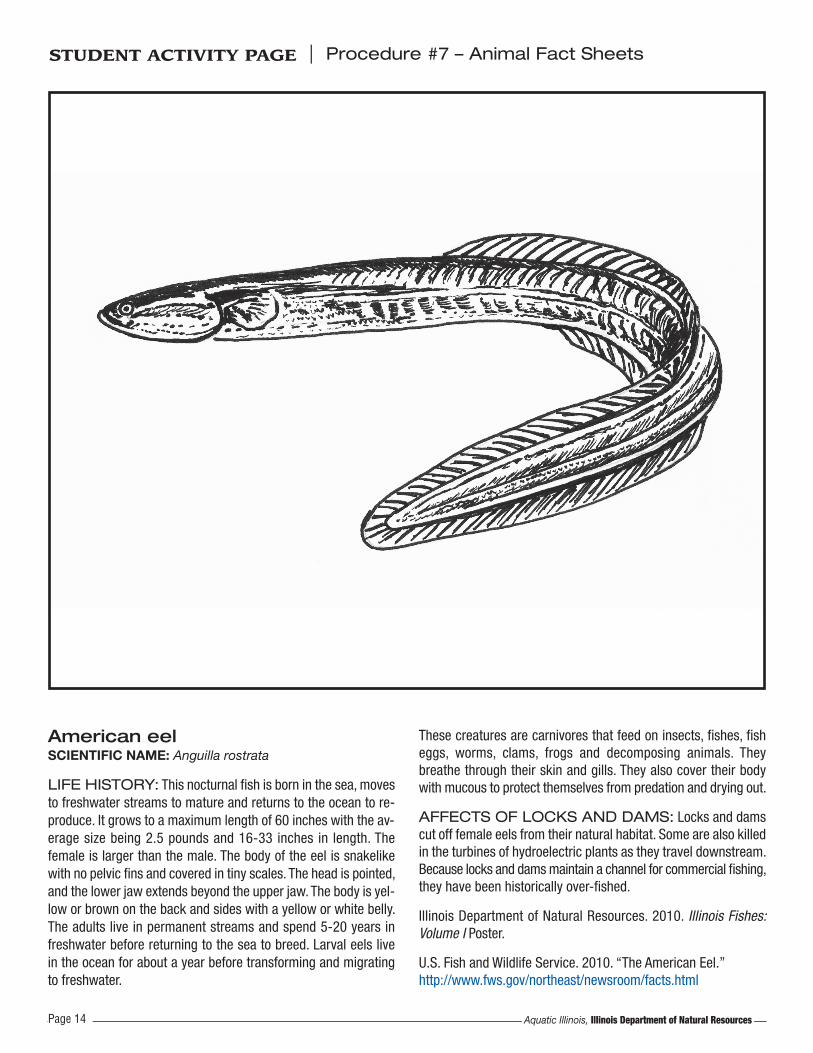
American eelSCIENTIFIC NAME: Anguilla rostrata
LIFE HISTORY: This nocturnal fish is born in the sea, movesto freshwater streams to mature and returns to the ocean to re-produce. It grows to a maximum length of 60 inches with the av-erage size being 2.5 pounds and 16-33 inches in length. Thefemale is larger than the male. The body of the eel is snakelikewith no pelvic fins and covered in tiny scales. The head is pointed,and the lower jaw extends beyond the upper jaw. The body is yel-low or brown on the back and sides with a yellow or white belly.The adults live in permanent streams and spend 5-20 years infreshwater before returning to the sea to breed. Larval eels livein the ocean for about a year before transforming and migratingto freshwater.
These creatures are carnivores that feed on insects, fishes, fisheggs, worms, clams, frogs and decomposing animals. Theybreathe through their skin and gills. They also cover their bodywith mucous to protect themselves from predation and drying out.
AFFECTS OF LOCKS AND DAMS: Locks and damscut off female eels from their natural habitat. Some are also killedin the turbines of hydroelectric plants as they travel downstream.Because locks and dams maintain a channel for commercial fishing,they have been historically over-fished.
Illinois Department of Natural Resources. 2010. Illinois Fishes:Volume I Poster.
U.S. Fish and Wildlife Service. 2010. “The American Eel.” http://www.fws.gov/northeast/newsroom/facts.html
Aquatic Illinois, Illinois Department of Natural Resources
STUDENT ACTIVITY PAGE | Procedure #7 – Animal Fact Sheets
Page 14

American white pelicanSCIENTIFIC NAME: Pelecanus erythrorhynchos
LIFE HISTORY: With a nine-foot wingspan, the usually silentAmerican white pelican is a large bird with an orange bill andexpandable throat pouch. It is migratory, moving north in Marchand south between September and November. Pelicans hunttogether in shallow lakes for fishes, crayfish and salamanders.They circle fishes or push them toward the shoreline. Then, theprey is scooped up by their bill and swallowed.
As soon as the birds meet and form a colony, they pair up, courtand nest next to a couple in the same stage of breeding. Both
sexes build a nest and incubate the two eggs to hatching. Whenthe young are 10-11 weeks old, they leave the nest.
AFFECTS OF LOCKS AND DAMS: The locks anddams on the upper Mississippi River have increased the habitatfor these birds. The migration path of the birds has been alteredby the creation of these structures, allowing the birds to nest inIllinois along the Mississippi River. The pools created by the locksand dams also provide them with prime hunting grounds.
Seattle Audubon Society. 2008. “Bird Web: American White Pelican.” http://www.seattleaudubon.org/birdweb/bird_details.aspx?id=33.
Aquatic Illinois, Illinois Department of Natural ResourcesPage 15
STUDENT ACTIVITY PAGE | Procedure #7 – Animal Fact Sheets

ebonyshell musselSCIENTIFIC NAME: Fusconaia ebena
LIFE HISTORY: This long-living freshwater mussel with abrown/black heavy, round shell can reach up to four inches inlength. The inner shell is white and once was harvested by com-mercial button-makers. It lives in large rivers in sand or gravelwith other species of mussels in mussel beds. The ebonyshell issedentary but can slowly pull itself across the aquatic floor usingits “foot.” It is a filter feeder on bacteria, protozoans, algae andother organic matter.
When reproducing, males release sperm into the water, which isdrawn into the female through the incurrent siphon. The spermfertilize the eggs inside the female’s body. The young develop toan intermediate stage, the glochidia, and are released into thewater. The young attach to this species’ fish host, the skipjack
herring (Alosa chrysochloris), and live as parasites until they de-velop into juvenile mussels. Then, they detach and fall to thestreambed.
AFFECTS OF LOCKS AND DAMS: This species oncewas one of the most abundant in the upper Mississippi River sys-tem, but it is quickly declining. The commercial button industryand pollution are partially to blame for the decline of this species,but a main reason for their decline is the blocking of the skipjackherring by locks and dams. The skipjack herring, a migratory fish,is the primary host for ebonyshell glochidia. Dams also increasesediment buildup in the river, choking the mussels on the bottomof the river.
Minnesota Department of Natural Resources. 2010. “Ebonyshell.”http://www.dnr.state.mn.us/rsg/profile.html?action=elementDe-tail&selectedElement=IMBIV17060.
Aquatic Illinois, Illinois Department of Natural ResourcesPage 16
STUDENT ACTIVITY PAGE | Procedure #7 – Animal Fact Sheets

skipjack herringSCIENTIFIC NAME: Alosa chrysochloris
LIFE HISTORY: This fish has a slender and compressedbody that can be gray/silver in color. It has a pointed snout andprotruding lower jaw with teeth on both the upper and lower jawsand the tongue. It can grow to 21 inches in length. It prefers clear,fast-flowing habitats in large rivers and feeds in large groups.Small fishes, plankton and insects compose its diet. Other namesfor this fish are blue herring, golden shad, river shad and shad.
AFFECTS OF LOCKS AND DAMS: This fish is thesole reproductive host for the ebonyshell mussel (Fusconaiaebena) and the elephant-ear mussel (Elliptio crassidens). Lockand dam structures keep most of these fish from migrating northin early spring because they cannot get past the dam, and theycannot use bypass canals. This stops the reproduction and life
cycle of these two species of freshwater mussels. In order to assistthe recovery of this species and the mussel species that dependon it, natural resource organizations must stock the fish in waterabove the dams.
Plans are being developed to provide a fish passage through thedams to prevent the extinction of the mussel species that areaffected. These lifts or ladders will allow the fish to pass throughthe dam.
Minnesota Department of Natural Resources. 2010. “SkipjackHerring.” http://www.dnr.state.mn.us/rsg/profile.html?action=el-ementDetail&selectedElement=AFCFA01030.
Wisconsin Department of Natural Resources. 2009. “SkipjackHerring.” http://dnr.wi.gov/org/land/er/biodiversity/index.asp?mode=info&Grp=13&SpecCode=AFCFA01030.
Aquatic Illinois, Illinois Department of Natural ResourcesPage 17
STUDENT ACTIVITY PAGE | Procedure #7 – Animal Fact Sheets