
Risk Assessment for Emergency Shelter Planning - · PDF fileEmergency Shelter Planning...
44
GRIP - Global Risk Identification Programme, UNDP Bureau for Crisis Prevention and Recovery, +41 22 9178399, [email protected], www.gripweb.org Regional training on Risk Assessment, Dakar – November 25-27, 2009 Risk Assessment for Emergency Shelter Planning UN-Habitat, IFRC, ProVention Consortium Global Risk Identification Program (GRIP) - Global Emergency Shelter Cluster -
Transcript of Risk Assessment for Emergency Shelter Planning - · PDF fileEmergency Shelter Planning...

GRIP - Global Risk Identification Programme, UNDP Bureau for Crisis Prevention and Recovery, +41 22 9178399, [email protected], www.gripweb.org
Regional training on Risk Assessment, Dakar – November 25-27, 2009
Risk Assessment for Emergency Shelter Planning
UN-Habitat, IFRC, ProVention ConsortiumGlobal Risk Identification Program (GRIP)
- Global Emergency Shelter Cluster -

GRIP - Global Risk Identification Programme, UNDP Bureau for Crisis Prevention and Recovery, +41 22 9178399, [email protected], www.gripweb.org
Regional training on Risk Assessment, Dakar – November 25-27, 2009
Information needed for Pre-Disaster Planning
• How many killed people are expected?• How many injured people are expected?• How many hospital beds are available?• How many displaced people are expected?• What are the most affected areas?• Where are the safer areas?• How many shelter-buildings are available?

GRIP - Global Risk Identification Programme, UNDP Bureau for Crisis Prevention and Recovery, +41 22 9178399, [email protected], www.gripweb.org
Regional training on Risk Assessment, Dakar – November 25-27, 2009
Simple Damage Estimation Software
CD-ROM including TOOLS and RADIUS city
reports. Distributed for FREE to city
administrators of cities worldwide by the UN and
RADIUS institutes.
RADIUS Tool

GRIP - Global Risk Identification Programme, UNDP Bureau for Crisis Prevention and Recovery, +41 22 9178399, [email protected], www.gripweb.org
Regional training on Risk Assessment, Dakar – November 25-27, 2009
Software Purposes
• To facilitate preliminary estimation of earthquake damage
• To be used by city administrators and general public, not for research purposes
• To assist in decision making• To raise awareness of
earthquake risk

GRIP - Global Risk Identification Programme, UNDP Bureau for Crisis Prevention and Recovery, +41 22 9178399, [email protected], www.gripweb.org
Regional training on Risk Assessment, Dakar – November 25-27, 2009
Software Characteristics
Goal: To make it as useful and accessible as possible
• Widely available platform (runs on MS-Excel)
• Simple, user-friendly– Help Function/User Instructions are included– Narrated Demonstration Video is included
• NOT a GIS(Geographic Information System) type of program– A GIS Sample is added for comparison (GIS is a very useful
risk-assessment tool)

GRIP - Global Risk Identification Programme, UNDP Bureau for Crisis Prevention and Recovery, +41 22 9178399, [email protected], www.gripweb.org
Regional training on Risk Assessment, Dakar – November 25-27, 2009
Input Data
Program uses commonly available city information
• Shape of target region (entered as a grid)• Population and its distribution• Building Inventory and its distribution• Ground Characteristics (Soil conditions) • Lifelines information• Choice of Scenario Earthquake and its parameters

GRIP - Global Risk Identification Programme, UNDP Bureau for Crisis Prevention and Recovery, +41 22 9178399, [email protected], www.gripweb.org
Regional training on Risk Assessment, Dakar – November 25-27, 2009
Outputs
• Ground Shaking Distribution (PGA or MMI Intensity)
• Building damage• Lifelines damage• Human Impact (number of deaths and injuries)• Summary Tables and Thematic Maps showing
the results

GRIP - Global Risk Identification Programme, UNDP Bureau for Crisis Prevention and Recovery, +41 22 9178399, [email protected], www.gripweb.org
Regional training on Risk Assessment, Dakar – November 25-27, 2009
Applications – Pre-Disaster Phase
• Shelter planning– Quantity– Location
• Legal and institutional agreements– Responsibilities at all levels– Inter-city agreements
• Revision of existing contingency plans• Simulation exercises

GRIP - Global Risk Identification Programme, UNDP Bureau for Crisis Prevention and Recovery, +41 22 9178399, [email protected], www.gripweb.org
Regional training on Risk Assessment, Dakar – November 25-27, 2009
Immediately after the disaster
• Very fast, accurate assessment of actual damages• Total physical and human impact• Most affected areas • Identification of safe areas• Shelter buildings that remain available• Response facilities still working (hospitals, fire
stations, police stations)• Accessibility conditions

GRIP - Global Risk Identification Programme, UNDP Bureau for Crisis Prevention and Recovery, +41 22 9178399, [email protected], www.gripweb.org
Regional training on Risk Assessment, Dakar – November 25-27, 2009
Immediately after the disaster
• Assessment of response capabilities• Setting up response priorities• Optimization of response resources• Refinement of response strategy• Monitoring of response implementation• Coordination and updating of response process

GRIP - Global Risk Identification Programme, UNDP Bureau for Crisis Prevention and Recovery, +41 22 9178399, [email protected], www.gripweb.org
Regional training on Risk Assessment, Dakar – November 25-27, 2009
Post-disaster phase
• Preparation of recovery scenarios to adjust shelter operations
• Preparation of recommendations for recovery planning• Control for no risk re-creation• Better coordination with early recovery activities• Design of exit strategies

GRIP - Global Risk Identification Programme, UNDP Bureau for Crisis Prevention and Recovery, +41 22 9178399, [email protected], www.gripweb.org
Regional training on Risk Assessment, Dakar – November 25-27, 2009
Methodology Development
• Pilot applications– Mozambique, Mexico, Nepal
• Training modules– Training for trainers– Self-teaching materials
• Large-scale implementation strategy– Recommendations

GRIP - Global Risk Identification Programme, UNDP Bureau for Crisis Prevention and Recovery, +41 22 9178399, [email protected], www.gripweb.org
Regional training on Risk Assessment, Dakar – November 25-27, 2009
Methodology Development
In parallel• Develop a new tool for floods risk
– Urban areas – Existing tool– Rural areas – New tool
• Timeline– First phase
• 3 Pilot applications – July 2009• Training modules – December 2009• New tool for Flood Risk – August 2009
– Second phase• Pilot applications of new tool – December 2010

GRIP - Global Risk Identification Programme, UNDP Bureau for Crisis Prevention and Recovery, +41 22 9178399, [email protected], www.gripweb.org
Regional training on Risk Assessment, Dakar – November 25-27, 2009
Long-term Implementation strategy
• Users– Local emergency response organizations– Local Red Cross International organizations
• Time requirements– Training and installation: 2-3 weeks– Pre-Disaster Shelter plan: 6 months
• Geographic scope– High-risk – Low-capacity countries– Medium and large cities (5/country)

GRIP - Global Risk Identification Programme, UNDP Bureau for Crisis Prevention and Recovery, +41 22 9178399, [email protected], www.gripweb.org
Regional training on Risk Assessment, Dakar – November 25-27, 2009
Risk Mapping for Strategic Planning of Shelter Response in Tijuana, Baja California, México
H. AYUNTAMIENTO TIJUANA B.C.
Antonio Rosquillas and Luis Moreno
Municipio de Tijuana
June 2009CENTRO DE INVESTIGACIÓN CIENTÍFICA Y DE EDUCACIÓN SUPERIOR DE ENSENADA.

GRIP - Global Risk Identification Programme, UNDP Bureau for Crisis Prevention and Recovery, +41 22 9178399, [email protected], www.gripweb.org
Regional training on Risk Assessment, Dakar – November 25-27, 2009
Area of Study: Tijuana Urban Area

GRIP - Global Risk Identification Programme, UNDP Bureau for Crisis Prevention and Recovery, +41 22 9178399, [email protected], www.gripweb.org
Regional training on Risk Assessment, Dakar – November 25-27, 2009
Components of EQ damage estimation
Propagation-Attenuation Law
epicenter
rockLocal soil conditions
hypocenter

GRIP - Global Risk Identification Programme, UNDP Bureau for Crisis Prevention and Recovery, +41 22 9178399, [email protected], www.gripweb.org
Regional training on Risk Assessment, Dakar – November 25-27, 2009
MUNICIPIODE
TIJUANA B.C.
DELEGATIONS AND EPICENTRAL
LOCATIONS (6) OF EARTHQUAKE SCENARIOS,
MAGNITUDE= 6.5
Plausible events

GRIP - Global Risk Identification Programme, UNDP Bureau for Crisis Prevention and Recovery, +41 22 9178399, [email protected], www.gripweb.org
Regional training on Risk Assessment, Dakar – November 25-27, 2009
GENERAL MESHORTOFOTO
MESH 500X500 meters
SAN ANTONIO BUENOS (SAB) DELEGATION
Mesh Generation (using aerial photos)
48 7131 49 72
17 32 50 73 9618 33 51 74 9719 34 52 75 98 120 14220 35 53 76 99 121 143 164 185 206
11 21 36 54 77 100 122 144 165 186 2071 6 12 22 37 55 78 101 123 145 166 187 208 2272 7 13 23 38 56 79 102 124 146 167 188 209 228 2453 8 14 24 39 57 80 103 125 147 168 189 210 229 2464 9 15 25 40 58 81 104 126 148 169 190 211 230 2475 10 16 26 41 59 82 105 127 149 170 191 212 231 248
27 42 60 83 106 128 150 171 192 213 23228 43 61 84 107 129 151 172 193 214 233 24929 44 62 85 108 130 152 173 194 215 234 250 26030 45 63 86 109 131 153 174 195 216 235 251 261 269 276
64 87 110 132 154 175 196 217 236 252 262 270 277 28388 111 133 155 176 197 218 237 253 263 271 278 284 290
65 89 112 134 156 177 198 219 238 254 264 272 279 285 291 29766 90 113 135 157 178 199 220 239 255 265 273 280 286 292 29867 91 114 136 158 179 200 221 240 256 266 274 281 287 293 299
46 68 92 115 137 159 180 201 222 241 257 267 275 282 288 294 30047 69 93 116 138 160 181 202 223 242 258 268 289 295 301
70 94 117 139 161 182 203 224 243 259 296 30295 118 140 162 183 204 225 244
119 141 163 184 205 226

GRIP - Global Risk Identification Programme, UNDP Bureau for Crisis Prevention and Recovery, +41 22 9178399, [email protected], www.gripweb.org
Regional training on Risk Assessment, Dakar – November 25-27, 2009
Soil Types Distribution in Tijuana

GRIP - Global Risk Identification Programme, UNDP Bureau for Crisis Prevention and Recovery, +41 22 9178399, [email protected], www.gripweb.org
Regional training on Risk Assessment, Dakar – November 25-27, 2009
SUPERPOSITION OF MESH AND SOIL TYPES (TOPOGRAPHY INCLUDED)
Soil Types Distribution
1 11 1 1
1 1 1 1 11 1 1 1 11 1 1 1 1 1 11 1 1 1 1 1 1 1 1 1
1 1 1 1 1 1 1 1 1 1 11 1 1 1 1 1 1 1 1 1 1 1 1 11 1 1 1 1 1 1 1 1 1 1 1 1 1 11 1 1 1 1 1 1 1 1 1 1 1 1 1 11 1 1 1 1 1 1 1 1 1 1 1 1 1 11 1 1 1 1 1 1 1 1 1 1 1 1 1 1
1 1 1 1 1 1 1 1 1 1 11 1 1 1 1 1 1 1 1 1 1 11 1 1 1 1 1 1 1 1 1 1 1 11 1 1 1 1 1 1 1 1 1 1 1 1 1 1
1 1 1 1 1 1 1 1 1 1 1 1 1 11 1 1 1 1 1 1 1 1 1 1 1 1 1
1 1 1 1 1 1 1 1 1 1 1 1 1 1 1 11 1 1 1 1 1 1 1 1 1 1 1 1 1 1 11 1 1 1 1 1 1 1 1 1 1 1 1 1 1 1
1 1 1 1 1 1 1 1 1 1 1 1 1 1 1 1 11 1 1 1 1 1 1 1 1 1 1 1 1 1 1
1 1 1 1 1 1 1 1 1 1 1 11 1 1 1 1 1 1 1
1 1 1 1 1 1

GRIP - Global Risk Identification Programme, UNDP Bureau for Crisis Prevention and Recovery, +41 22 9178399, [email protected], www.gripweb.org
Regional training on Risk Assessment, Dakar – November 25-27, 2009
TYPE 0
TYPE 1
TYPE 2
TYPE 3
Population Distribution
MESH WEIGHT BY POPULATION DENSITY using aerial photo

GRIP - Global Risk Identification Programme, UNDP Bureau for Crisis Prevention and Recovery, +41 22 9178399, [email protected], www.gripweb.org
Regional training on Risk Assessment, Dakar – November 25-27, 2009
Building Types Distribution (SAB)

GRIP - Global Risk Identification Programme, UNDP Bureau for Crisis Prevention and Recovery, +41 22 9178399, [email protected], www.gripweb.org
Regional training on Risk Assessment, Dakar – November 25-27, 2009
Building Distribution for SAB Delegation
Area ID Area Name
RES1 (%)
RES2 (%)
RES3 (%)
RES4 (%)
EDU1 (%)
EDU2 (%)
MED1 (%)
MED2 (%)
COM (%)
IND (%)
Sum (%)
1 SAB 60 35 0 5 0 0 0 0 0 0 100

GRIP - Global Risk Identification Programme, UNDP Bureau for Crisis Prevention and Recovery, +41 22 9178399, [email protected], www.gripweb.org
Regional training on Risk Assessment, Dakar – November 25-27, 2009
Scenario Earthquake EQ6

GRIP - Global Risk Identification Programme, UNDP Bureau for Crisis Prevention and Recovery, +41 22 9178399, [email protected], www.gripweb.org
Regional training on Risk Assessment, Dakar – November 25-27, 2009
MMI Intensity Distribution
RADIUS calculates PGA and then Mercalli Modified Intensities (MMI)
d dd d d
d d d d dd d d d dd d d d d d dd d d d d d d d d d
c c c c d d d d d d dc c c c c c c c c c d d c cc c c c c c c c c c d d d c cc c c c c c c c c c d d c c cc c c c c c c c c c c c c c cc c c c c c c c c c c c c c c
c c c c c c c c c c ca a c c c c c c c c c ca a a c c c c c c c c c ca a a a c c c c c c c c c c c
a a c c c c c c c c c c c ca c c c c c c c c c c c c c
c c c c c c c c c c c c c c c cc c c c c c c c c c c c c c c cc c c c c c c c c c c c c c c c
c c c c c c c c c c c c c c c c ca a c c c c c c c c c c c c c
a b c c c c c c c c c cb b b b b b b b
b b b b b b

GRIP - Global Risk Identification Programme, UNDP Bureau for Crisis Prevention and Recovery, +41 22 9178399, [email protected], www.gripweb.org
Regional training on Risk Assessment, Dakar – November 25-27, 2009
Building Damage Estimation (SAB)
c cc c c
c c c c cc d c c cb d d c c c bc c c c c c b a b c
a c c c b c c c c c ba a a c c c c b c c d c b cb a a c c c b b c c c d c b ac b b b c c a a c c d d c b aa b c b c b a a b c b c b c ba a b a b a a a a a b c a b b
a a a a a a a a a a ba a a a a a a a a a b ba a a a a a a a a a a a aa a a a a a a a a a a a a b a
a a a a a a a a a a a b b aa a b a a a a a a b a b b b
a a a a b b a a a b b b b b a aa a a b b b b a a b a a b a a aa a a a a a a a a b b a a a a a
a a a a a a a a a a a b A a a a aa a a a a a a a a a a a a a a
a a a a a a a a a a a aa a a a a a a a
a a a a a a
Automatic Range Manual RangeColor ID From To From Toa 0 18 0 18b 18 35 18 35c 35 53 35 53d 53 70 53 70

GRIP - Global Risk Identification Programme, UNDP Bureau for Crisis Prevention and Recovery, +41 22 9178399, [email protected], www.gripweb.org
Regional training on Risk Assessment, Dakar – November 25-27, 2009
Shelter Needs Results
SAB CEN CTO CCO CVE LME PRE OTA PLA TAB TotalEQ1 10,000 4,622 8,917 3,282 1,226 5,839 7,276 4,497 6,372 6,246 58,277EQ2 12,392 4,593 6,853 3,661 3,184 7,012 8,576 3,341 5,335 9,503 64,449EQ3 3,025 2,792 1,942 2,400 1,360 2,751 8,457 1,266 947 3,648 28,588EQ4 12,465 10,140 11,085 6,676 1,703 9,942 15,133 7,984 6,019 10,169 91,316EQ5 4,986 4,504 2,900 4,289 2,581 5,317 16,561 1,993 1,456 6,338 50,925EQ6 6,411 6,063 5,761 3,581 1,032 4,979 8,437 3,985 3,216 4,979 48,444
Number of people needing shelter for each of the six scenario earthquakes

GRIP - Global Risk Identification Programme, UNDP Bureau for Crisis Prevention and Recovery, +41 22 9178399, [email protected], www.gripweb.org
Regional training on Risk Assessment, Dakar – November 25-27, 2009
Damage to lifelines

GRIP - Global Risk Identification Programme, UNDP Bureau for Crisis Prevention and Recovery, +41 22 9178399, [email protected], www.gripweb.org
Regional training on Risk Assessment, Dakar – November 25-27, 2009
SHELTERS PLANNING
- GENERAL CRITERIA -
GRIP - Global Risk Identification Programme, UNDP Bureau for Crisis Prevention and Recovery, +41 22 9178399, [email protected], www.gripweb.org
Regional training on Risk Assessment, Dakar – November 25-27, 2009
TEMPORAL SHELTERS IN MEXICO
• The National Defense Ministry is the first responsible office
• Schools are the first option for shelter
• For long-term dwelling rehabilitation, the arrangement of organized camps has been foreseen
• In Mexico, there is not any experience of temporal shelter provision in case of an earthquake.

GRIP - Global Risk Identification Programme, UNDP Bureau for Crisis Prevention and Recovery, +41 22 9178399, [email protected], www.gripweb.org
Regional training on Risk Assessment, Dakar – November 25-27, 2009
Shelter deployment criteria
• Based on the damage scenario, schools located in areas of intensity less than VII, were chosen to be used. An average of 300 sheltered persons per school has been considered
• The open spaces (sport fields and parks bigger than 1000 m²) in the areas with intensity VII and up
• In the organized camps, local building materials will be used first and, if necessary, tents and camping houses

GRIP - Global Risk Identification Programme, UNDP Bureau for Crisis Prevention and Recovery, +41 22 9178399, [email protected], www.gripweb.org
Regional training on Risk Assessment, Dakar – November 25-27, 2009
MMI Intensities for deployment criteria (EQ4)

GRIP - Global Risk Identification Programme, UNDP Bureau for Crisis Prevention and Recovery, +41 22 9178399, [email protected], www.gripweb.org
Regional training on Risk Assessment, Dakar – November 25-27, 2009
Institutional and legal frameworks
• The National Defense Ministry will apply the Plan DNIII created for natural disasters
• The local authority will use Project Sphere (IFRC) criteria for minimum requirements
• The local government, with the assistance of State and Federal governments, will provide the necessary supplies to all shelters
• Areas for supply centers and for foreign humanitarians teams arealso identified

GRIP - Global Risk Identification Programme, UNDP Bureau for Crisis Prevention and Recovery, +41 22 9178399, [email protected], www.gripweb.org
Regional training on Risk Assessment, Dakar – November 25-27, 2009
COORDINATION
• Participants:
• Municipality• State Government• Federal Government• National Defense Ministry.• Marine Ministry• Red Cross• Volunteer Associations• International Humanitarian Institutions and other countries

GRIP - Global Risk Identification Programme, UNDP Bureau for Crisis Prevention and Recovery, +41 22 9178399, [email protected], www.gripweb.org
Regional training on Risk Assessment, Dakar – November 25-27, 2009
MORELOS PARK (open space) Area = 560 000 m² Shelter for 1000 people (42m2/person)

GRIP - Global Risk Identification Programme, UNDP Bureau for Crisis Prevention and Recovery, +41 22 9178399, [email protected], www.gripweb.org
Regional training on Risk Assessment, Dakar – November 25-27, 2009
ALAMAR RIVER (open space) Area = 924,638 m² Shelter for 20,000 people (risky in raining season)

GRIP - Global Risk Identification Programme, UNDP Bureau for Crisis Prevention and Recovery, +41 22 9178399, [email protected], www.gripweb.org
Regional training on Risk Assessment, Dakar – November 25-27, 2009
GOLF COURSE (open space) Area = 429,203 m² Shelter for 10,000 people (private)

GRIP - Global Risk Identification Programme, UNDP Bureau for Crisis Prevention and Recovery, +41 22 9178399, [email protected], www.gripweb.org
Regional training on Risk Assessment, Dakar – November 25-27, 2009
AIRPORT (open space) Area = 593,234 m² External supplies reception

GRIP - Global Risk Identification Programme, UNDP Bureau for Crisis Prevention and Recovery, +41 22 9178399, [email protected], www.gripweb.org
Regional training on Risk Assessment, Dakar – November 25-27, 2009
SPORT FIELDS Area = 358,115 m² Shelter for foreign teams (near airport)

GRIP - Global Risk Identification Programme, UNDP Bureau for Crisis Prevention and Recovery, +41 22 9178399, [email protected], www.gripweb.org
Regional training on Risk Assessment, Dakar – November 25-27, 2009
RACE TRACK Area = 362,974 m² Shelter for 7,500 people (private)

GRIP - Global Risk Identification Programme, UNDP Bureau for Crisis Prevention and Recovery, +41 22 9178399, [email protected], www.gripweb.org
Regional training on Risk Assessment, Dakar – November 25-27, 2009
MILITARY FIELD Area = 1,135,277 m² Supplies
GRIP - Global Risk Identification Programme, UNDP Bureau for Crisis Prevention and Recovery, +41 22 9178399, [email protected], www.gripweb.org
Regional training on Risk Assessment, Dakar – November 25-27, 2009
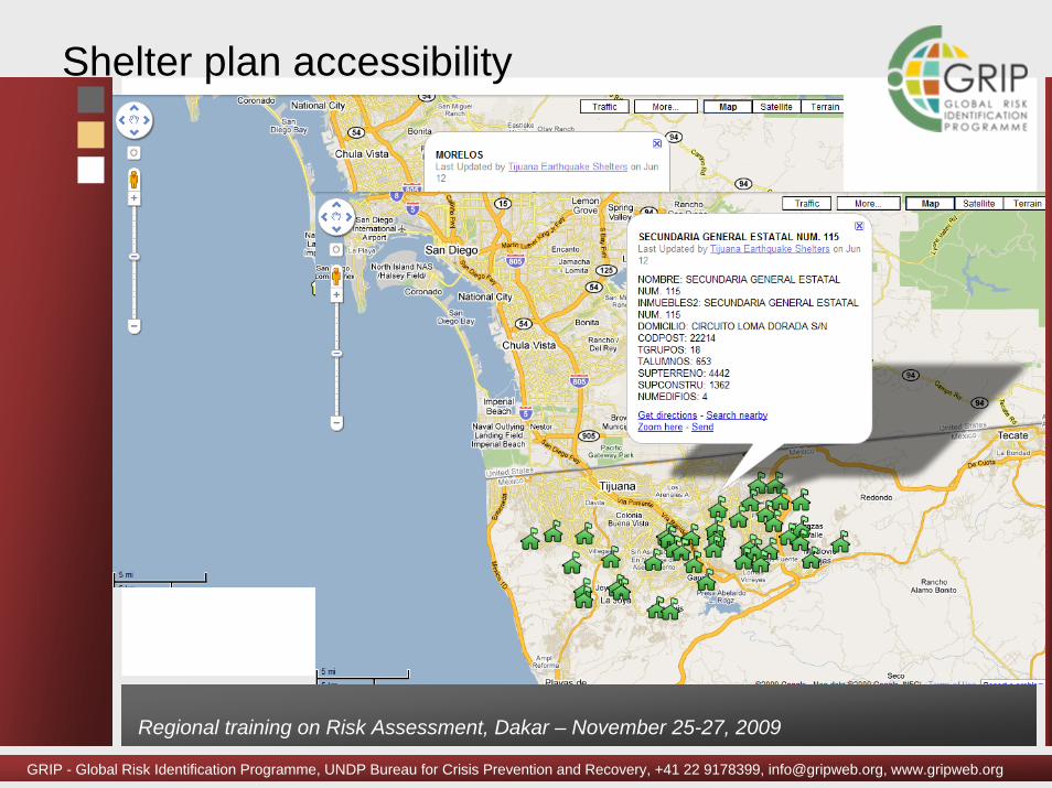
Shelter plan accessibility

GRIP - Global Risk Identification Programme, UNDP Bureau for Crisis Prevention and Recovery, +41 22 9178399, [email protected], www.gripweb.org
Regional training on Risk Assessment, Dakar – November 25-27, 2009
Simulation exercise (Sept. 18, 2009)


