Rio/29 Future Land Use Alternatives€¦ · vDesk User 2 Created Date: 12/13/2016 2:48:58 PM ...
41
Rio/29 Small Area Plan Phase 1 December 12, 2016 Rio/29 – Future Land Use Alternatives
Transcript of Rio/29 Future Land Use Alternatives€¦ · vDesk User 2 Created Date: 12/13/2016 2:48:58 PM ...

Rio/29 Small Area Plan Phase 1
December 12, 2016
Rio/29 – Future Land Use Alternatives

1
2
3
4
5
1 BACKGROUND
2
ALTERNATIVES
OPEN HOUSE
2 COMMUNITY INPUT
3 DESIGN PRINCIPLES
PRESENTATION OVERVIEW

1 PROJECT BACKGROUND
3

Comprehensive
Plan
Places29
Master Plan
Rio/29
Small Area Plan
• Coverage area: County-wide
• Broad range of goals and objectives covering multiple topics.
• Last updated June 10, 2015
• Coverage area: Development Area
• Provides a more detailed future land use map, transportation, parks, community facilities.
• Adopted February 2011
• Coverage area: Neighborhood
• More detailed land use, transportation plan, design
• To be completed in 2017
PLANNING CONTEXT
BACKGROUND

Compact development….organized around centers
Pedestrian-oriented and mixed-use….variety of housing choices, retail environments, office types, and employment opportunities
Connected by…multimodal transportation
Parks and open spaces…contribute to an overall excellent quality of life
PLACES 29 VISION
BACKGROUND

STUDY AREA

Initiation/ Reconnaiss
ance
Market Assessment
Study Area Analysis
Alternatives Generation
Final Document
MILESTONES
BACKGROUND
PHASE 1
• An overarching vision for
the Rio/29 small area
• Identification of some
early actions to
implement this vision
PHASE 2
• A detailed Area Plan that
supports implementation
of the vision
Phase 1 Timeline (10-months)

WHY IS THIS IMPORTANT?
BACKGROUND8
Land Area
29 North Remainder of County
Sales/Business Tax Revenue
29 North Remainder of County
Source: Albemarle County
Note: Data show that the 29 North Business Corridor accounts for roughly 42.4% of the selected revenue sources in the County –
business license tax, motor vehicle dealer tax, food and beverage tax, short term rental tax, transient occupancy tax, and sales tax.
These taxes in aggregate across the County represent 7.0% of the total County Tax Revenue for FY13/14

RIO/29 PAST & PRESENT
9
1957
2014
BACKGROUND

PURPOSE
BACKGROUND10
WHAT
• Land Use Alternatives
• Show where and how
development could occur
• Long-term (up to 50 years)
WHY
• To explain tradeoffs
• To gather public input
• To define a preferred vision of
future development
• To guide Phase 2

PURPOSE
BACKGROUND
Tonight – To provide input on what you see as the pros and cons for each alternative
Things to keep in mind
• Node locations
• Intensity and amount of future development
• Transportation
• Potential economic impact
• Potential county costs and revenues
• Consistency with Places29 vision

2 COMMUNITY INPUT

WHAT HAVE WE HEARD SO FAR?
COMMUNITY INPUT 13
Advisory Committee
Community Meeting
Business/Land Owners Focus Group
Staff Technical Committee
Young Professionals Mixer

VISION THEMES

1. PLACE MAKING: Create a place where people and employers want to be
2. MIXED USE: Introduce more housing and employment uses to make a complete community
3. MULTIMODAL: Connectivity, transit, trails, and walk/bike friendly streets
4. OPEN SPACE & RECREATION: Parks, open spaces, buffers and river access
5. NEIGHBORHOOD PROTECTION: Balance the need for height and density to make redevelopment feasible with community concerns about local impacts and view sheds
6. INTERGENERATIONAL COMMUNITY: Mix of housing types and transportation options to meet the needs of people of all ages
7. VISITOR GATEWAY: Design and gateway features tell travelers they have arrived in a special place
GUIDING PRINCIPLES - PLAN
COMMUNITY INPUT

3 DESIGN PRINCIPLES

The Urban Land Institute identifies 10 core principles for “Reinventing the Suburban Strip”
PULSES OF DEVELOPMENT
DESIGN PRINCIPLESwww.uli.org/wp-content/uploads/ULI-Documents/Tp_SuburbanStrips
Core Principle

FUTURE TRANSIT AS AN ORGANIZING FEATURE
DESIGN PRINCIPLESSource: Places29

A NOTE ON TRANSIT ORIENTED DEVELOPMENT
DESIGN PRINCIPLES 19
TOD
ECONOMIC DEVELOPMENT
LIVABLE COMMUNITIES TRAVEL CHOICES
CHARACTERISTICS OF SUCCESSFUL TOD CHARACTERISTICS OF SUCCESSFUL COMMUNITY=

10-15-MINUTE WALKABLE COMMUNITY
DESIGN PRINCIPLES
Source: Places 29

Downtown Charlottesville
Source: Pictometry

RIO/29
Source:
Pictometry

Stonefield
Source: Pictometry
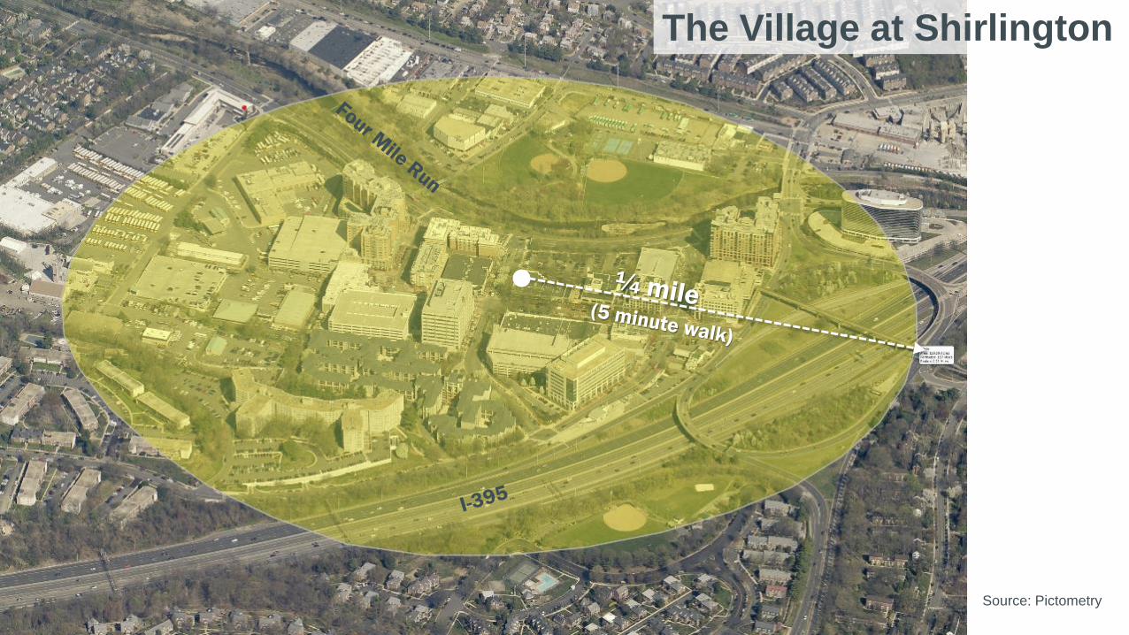
The Village at Shirlington
Source: Pictometry

North Hills, Raleigh, NC
Source: Pictometry

HOW THE ALTERNATIVES WERE DEVELOPED
DESIGN PRINCIPLES 26
PLACES 29/PLANS
PUBLIC /
STAKEHOLDER INPUT
PLANNING PRINCIPLES

ALTERNATIVE A ALTERNATIVE B ALTERNATIVE C

What about areas
outside the Nodes?
• Develop as a mixture of
the following uses:
What about other
centers?• Secondary centers
along Berkmar could be
served by local
circulator bus lines

ALTERNATIVE A ALTERNATIVE B ALTERNATIVE C
WHAT DO THESE ALTERNATIVES IMPLY?
• FUTURE OF THE CORRIDOR SHOULD CENTER ON “NODES”
OR CENTERS OF DEVELOPMENT
• HOW MANY CENTERS AND WHERE?
• WHAT SHOULD THE CENTERS LOOK LIKE?
• WHAT ABOUT AREAS OUTSIDE THE CENTERS?

WHAT COULD THE CENTERS LOOK LIKE?

ALTERNATIVE A ALTERNATIVE B ALTERNATIVE C
NEXT STEPS
• GET INPUT ON A ‘PREFERRED ALTERNATIVE’
• PREPARE REPORT ON FINDINGS TO CLOSE OUT PHASE 1
• PHASE 2 TO ADDRESS A MORE DETAILED PLAN AND
IMPACT ANALYSIS

5 OPEN HOUSE

First, any general questions?
At each station, please provide input on what you see as the pros and cons for each alternative
OPEN HOUSE
OPEN HOUSE 33
Things to keep in mind
• Node locations
• Intensity and amount of future development
• Transportation
• Potential economic impact
• Potential county costs and revenues
• Consistency with Places29 vision

34
BRT EXAMPLE

35
BRT EXAMPLE

Assembly Row, Somerville, MA

Virginia Beach Town Center, VA

Oyster Point City Center, Newport News, VA

Carlisle, Alexandria, VA

Reston Town Center, Fairfax County, VA

Reston Town Center, Fairfax County, VA