
Ridgeway Terrain Profile - Marlborough Running Club · The Ridgeway is clearly marked on the OS and...
16
1 29 th RIDGEWAY RELAY Sunday 17 th JUNE 2018 Race Permit #: ARC 18/093 RACE INFORMATION (v.2018.1) Team captains are asked to distribute this race information pack to all members of their team. Maps and Further Route Information The route follows the official Ridgeway National Trail, except for a diversion on stage nine to avoid a dangerous road crossing South of Ogbourne St. George, and a diversion on stage ten across the Marlborough Downs to the finish at Marlborough Leisure Centre. The total distance is 89 miles. Runners who gain advantage by deviating from the route are liable to incur time penalties. Ridgeway Terrain Profile 0 50 100 150 200 250 300 0 3 6 10 13 16 19 23 26 29 32 36 39 42 45 48 52 55 58 61 65 68 71 74 78 81 84 87 Distance (miles) Terrain Height (m) . leg1 11.0 452 543 leg2 6.0 352 248 leg3 9.4 273 357 leg4 5.4 169 141 leg5 10.1 171 307 leg6 10.4 323 184 leg7 9.1 198 149 leg8 7.8 183 177 leg9 10.7 338 309 leg10 9.4 163 291 leg no. dist.(mi) total climb (m ) total descent (m) The stages of the route are plotted on MapMyRun.com. References are given below. The distances given by MapMyRun don’t quite agree with those given in the above chart, which was produced using commercial mapping software, but we will stick to those shown here as the “official” mileages. All runners/teams are responsible for undertaking their own navigational research. Available from most good bookshops are several publications giving details of the Ridgeway Path, including: National Trail Guide - 'The Ridgeway' (which includes OS 1:25,000 maps of the whole route, and gives an excellent guide for negotiating the Ridgeway on foot – but in the reverse direction to the Relay!) The HMSO book, 'The Ridgeway Path', published for the Countryside Commission. The Cicerone guide to the Ridgeway https://www.cicerone.co.uk/product/detail.cfm/book/874/title/the-ridgeway-national-trail#.WSKl11LMxUN
Transcript of Ridgeway Terrain Profile - Marlborough Running Club · The Ridgeway is clearly marked on the OS and...
1
29th RIDGEWAY RELAY Sunday 17th JUNE 2018
Race Permit #: ARC 18/093
RACE INFORMATION (v.2018.1)
Team captains are asked to distribute this race information pack to all members of their team.
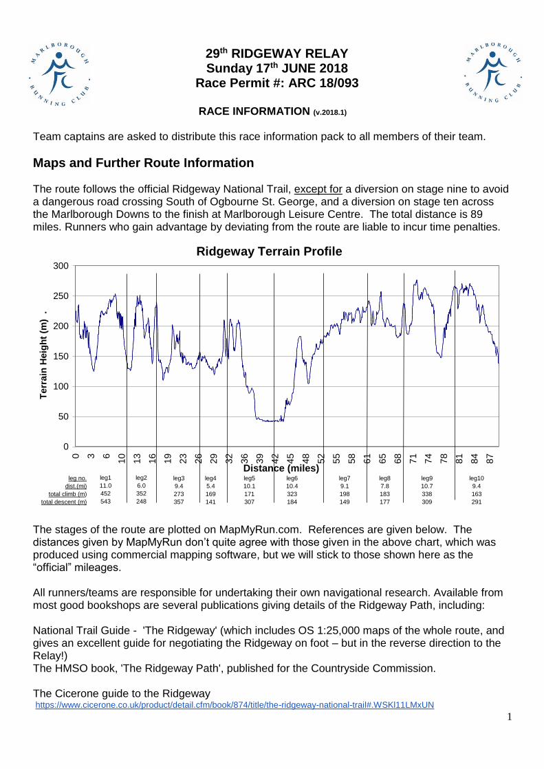
Maps and Further Route Information The route follows the official Ridgeway National Trail, except for a diversion on stage nine to avoid a dangerous road crossing South of Ogbourne St. George, and a diversion on stage ten across the Marlborough Downs to the finish at Marlborough Leisure Centre. The total distance is 89 miles. Runners who gain advantage by deviating from the route are liable to incur time penalties.
Ridgeway Terrain Profile
0
50
100
150
200
250
300
0 3 6
10
13
16
19
23
26
29
32
36
39
42
45
48
52
55
58
61
65
68
71
74
78
81
84
87
Distance (miles)
Te
rra
in H
eig
ht
(m)
.
leg1
11.0
452
543
leg2
6.0
352
248
leg3
9.4
273
357
leg4
5.4
169
141
leg5
10.1
171
307
leg6
10.4
323
184
leg7
9.1
198
149
leg8
7.8
183
177
leg9
10.7
338
309
leg10
9.4
163
291
leg no.
dist.(mi)
total climb (m)
total descent (m)
The stages of the route are plotted on MapMyRun.com. References are given below. The distances given by MapMyRun don’t quite agree with those given in the above chart, which was produced using commercial mapping software, but we will stick to those shown here as the “official” mileages. All runners/teams are responsible for undertaking their own navigational research. Available from most good bookshops are several publications giving details of the Ridgeway Path, including: National Trail Guide - 'The Ridgeway' (which includes OS 1:25,000 maps of the whole route, and gives an excellent guide for negotiating the Ridgeway on foot – but in the reverse direction to the Relay!) The HMSO book, 'The Ridgeway Path', published for the Countryside Commission. The Cicerone guide to the Ridgeway https://www.cicerone.co.uk/product/detail.cfm/book/874/title/the-ridgeway-national-trail#.WSKl11LMxUN
2
It is recommended that all competing teams get a copy of one of the above, plus the relevant Ordnance Survey maps: - Landranger Series (Scale 1:50,000)
Map No. 165 Aylesbury and Leighton Buzzard area. Map No. 175 Reading and Windsor area.
Map No. 174 Newbury and Wantage area. Map No. 173 Swindon and Devizes area.
The ten stages of the race will be found on these maps as follows:
- Stages 1, 2 and 3: Map 165 - Stage 4: Maps 165 & 175 - Stage 5: Maps 175 & 174 - Stage 6: Maps 175 & 174 - Stages 7 and 8: Map 174 - Stage 9: Maps 174 & 173 - Stage 10: Map 173
The larger scale Explorer range of maps is also ideal.
Or, to cover the whole route in one go, get Harvey’s Ridgeway map (1:40,000). Available from www.harveymaps.co.uk, Amazon, and bookshops.
Driving directions from the start to the finish via all the checkpoints have been created in Google Maps. See http://tinyurl.com/yajny6r. From this site road maps and directions listings may be printed.
If, while checking your section of the route, you find a problem, (a new by-pass has been built; Gypsy caravans blocking the way, etc.) Please let me know so that action may be taken to alleviate the problem. Thank you.
General Information
Start time 7.30am Ivinghoe Beacon
The Ridgeway Relay generally follows the official route of The Ridgeway National Trail, starting from Ivinghoe Beacon. The Ridgeway is clearly marked on the OS and Harvey Maps.
We deviate from the official Ridgeway in two places. On Stage 9, to avoid a dangerous road crossing, we divert through the village of Ogbourne St George. On Stage 10, at the end, we leave The Ridgeway about 1¾ miles from the end, and turn left across the Marlborough Downs to finish at Marlborough Leisure Centre. This section is not marked, and it is important to follow the directions given in stage 10 details.
Although the Ridgeway is generally marked on the ground by signposts bearing the acorn symbols used to mark all National Trails, there are places where these are not well positioned, and it is easy to run past and miss them. The direction is not always obvious when you are running hard, and all competitors are therefore advised to run, walk or ride their stages before the day of the Race if they can. This is particularly important for the first half of the course, where the path is often narrow, in woods, and crossed by other similar paths. After Goring it is mostly wider and in more open countryside, but route checking is still recommended. YOU HAVE BEEN WARNED!
All runners/teams are responsible for making their own travel arrangements to and from each checkpoint.
3
Team Members’ Details So that we can record the names of all runners in the results, Team Captains will be asked to record details of the runners for their teams on each stage by logging onto the Marlborough Running Club website: http://www.marlboroughrunningclub.co.uk/ridgewayrelay.shtm Details of how to do this will be communicated to team captains by e mail. The e-mail address for the event is: [email protected]
Race Numbers The marshals at the start of each stage will issue the race numbers to competitors on that stage. Safety pins will also be provided. Runners should report to the marshals at least 10 minutes before they expect to set off. Runners are asked to record their names and any relevant medical details on the back of the numbers.
Club Colours Please encourage all your team runners to wear their club colours. It helps the marshals at checkpoints to recognise teams when they are finishing
Health and Safety
Like any trail race, the Ridgeway Relay is not entirely free from hazards and risks of injury. Hazards include:
Road crossings, and one rail crossing (note – most road crossings will not be marshalled),
Stiles, which may be slippery, especially if it is wet or muddy,
Uneven paths, with ruts or roots coming up through the ground,
Slippery grass paths,
Tripping on stony tracks.
The British weather. Who knows? Very hot, monsoon rain. Be prepared for whatever.
All runners are expected to take reasonable measures to recognise potential hazards and avoid injury to themselves and others, and to take sensible precautions in case of any injury. Runners are strongly advised to carry a mobile phone, a list of emergency telephone numbers (which appear on the reverse side of the race numbers) and contact numbers for their team members. In the event of one or more of your team getting lost, it is the responsibility of your team to get out there and find them. (Locating lost runners is another reason for advising runners to carry mobile phones. In previous Ridgeway Relays at least one runner has been lost for an hour or more. If they had been carrying phones this would have been avoided. Fortunately, every such lost runner was found by nightfall on race day – though in one case only just!) Because of the nature of the event and the course, it is impractical for the organisers to provide full effective first aid cover. Team members are advised to carry basic first aid supplies. If first aid is needed that cannot be provided by another team member or a nearby marshal, use an A&E
4
Department in the nearby hospitals. Locations of these and their phone numbers are given at the end of this document, and on the reverse side of the running numbers. Team members should note that no toilet facilities will be provided at the start or along the route. Public facilities are available in nearby towns and villages (for example, near the start at Tring Station), and at the end of stage nine, and for customers of the Perch and Pike at the end of stage five. Changing and toilet facilities will available for all competitors in Marlborough Leisure Centre at the finish.
Water Note that the organisers will not be providing water or other drinks for runners at checkpoints or along the route. It is each team’s responsibility to make appropriate arrangements for their runners.
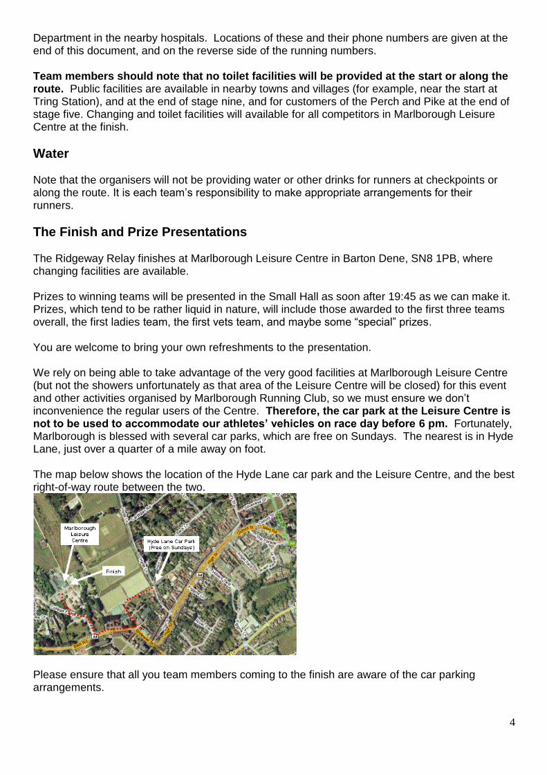
The Finish and Prize Presentations The Ridgeway Relay finishes at Marlborough Leisure Centre in Barton Dene, SN8 1PB, where changing facilities are available. Prizes to winning teams will be presented in the Small Hall as soon after 19:45 as we can make it. Prizes, which tend to be rather liquid in nature, will include those awarded to the first three teams overall, the first ladies team, the first vets team, and maybe some “special” prizes. You are welcome to bring your own refreshments to the presentation. We rely on being able to take advantage of the very good facilities at Marlborough Leisure Centre (but not the showers unfortunately as that area of the Leisure Centre will be closed) for this event and other activities organised by Marlborough Running Club, so we must ensure we don’t inconvenience the regular users of the Centre. Therefore, the car park at the Leisure Centre is not to be used to accommodate our athletes’ vehicles on race day before 6 pm. Fortunately, Marlborough is blessed with several car parks, which are free on Sundays. The nearest is in Hyde Lane, just over a quarter of a mile away on foot. The map below shows the location of the Hyde Lane car park and the Leisure Centre, and the best right-of-way route between the two.
Please ensure that all you team members coming to the finish are aware of the car parking arrangements.
5
Restaurants in Marlborough For anyone wanting to have a meal in Marlborough at the end of the day, here is a list of local restaurants showing which serve food on Sunday evenings.
Ask Italian 101 High Street,
Marlborough, SN8 1HD
01672
515797
https://www.askitalian.co.uk/restaurant/MARLBOROUGH/
Prezzo 99 High Street, Marlborough,
SN8 1HD
01672
511181
https://www.pizzaexpress.com/marlborough
Pizza
Express
37 High Street, Marlborough,
SN8 1LW
01672
519229
http://www.pizzaexpress.com/our-
restaurants/2631/marlborough.aspx
Castle &
Ball Hotel
High Street, Marlborough,
SN8 1LZ
Recommended for good
value food.
01672
515201
http://www.oldenglishinns.co.uk/marlborough/
Pino’s
Ristorante
13 New Road,Marlborough,
SN8 1AH 01672
512969
http://www.pinosristorante.co.uk/context/marlborough.html
Raj 47 Kingsbury Street,
Marlborough SN8 1JE
01672
515661
No website
The Royal
Oak
111 High Street,
Marlborough, SN8 1LT
Recommended for good
value food.
01672
512064
http://www.gkpubs.co.uk/pubs-in-marlborough/royal-oak-
pub/
Rick Stein Lloran House, 42a High
Street, Marlborough,
Wiltshire, SN8 1HQ
01672
233333
https://www.rickstein.com/eat-with-us/marlborough/
Facilities in South Stoke. End of Stage 5, start of stage 6 The half-way point of the race is in the very attractive village of village of South Stoke, north of Goring. In South Stoke the race passes the Perch and Pike (http://www.perchandpike.co.uk/). They offer both food and drink. Please do not use the Perch and Pike car park or other facilities unless you are a customer. Just a short distance off the route, at the Recreation Ground, is the Village Community Shop, open from 09:00 to 12:00 on a Sunday morning. The full range of facilities will be available including alcoholic and soft drinks as well as coffee and tea. They would be pleased to take advance orders for hot pies and pasties. Give them about half an hour to prepare them.
6
Route Descriptions As a general comment for all check points, please inform team members to warm up away from the CP changeover point, it can be difficult for marshalls to identify runners finishing with other runners warming up. Stage 1: Ivinghoe Beacon SP 961 168 to Wendover SP 873 072 http://tinyurl.com/m6xf2b8 to http://tinyurl.com/ktfy69g Route map: http://www.mapmyrun.com/gb/ivinghoe-eng/ridgeway-relay-stage-1-ivinghoe-beacon-w-route-2617318
Use the Car Park south of the Beacon, map reference 963 163, and walk back up the Ridgeway Path approximately 600 yards. Allow 20 minutes for this walk, and it is likely to be chilly at 7am, so dress accordingly. Use the footpath among the trees to get to the Beacon not the road. Please do NOT park on the road. The Police have been known to move cars on, even that early on a Sunday morning. Navigationally this is a tricky stage, which needs to be checked before the Race, as several competitors have discovered in the past! The first half is physically quite tough, lots of hill-work, although the last 5 or 6 miles are predominantly flat or downhill. There are several road crossings to negotiate. Most are quiet, needing the usual degree of care, but particular care is needed at Wigginton (SP 934105) where traffic coming up the hill from your right has a restricted view. Particular care is needed here. As some teams are already aware, there are several handy short cuts on Stage 1, such as the one going straight on at SP 896077. Using this will give your team an advantage of about a mile. However, it will also incur your team a hefty time-penalty! Please stick to the official Ridgeway Path. The handover is on the road approaching a small crossroads before the church on the SE of the town. For parking please use Fostercare Associates car park SP 873 072 and the no through road leading to it. Stage 2: Wendover SP 873 072 to Whiteleaf Car Park E. of Princes Risborough SP 824 037 http://tinyurl.com/ktfy69g to http://tinyurl.com/jvvk4f8 Route map: http://www.mapmyrun.com/gb/wendover-eng/ridgeway-relay-stage-2-wendover-white-le-route-2636916
The handover is on the road approaching a small crossroads before the church on the SE of the town. Please do not go up the road and obstruct the marshals’ view. For parking please use Fostercare Associates car park SP 873 072 and the no through road leading to it.
7
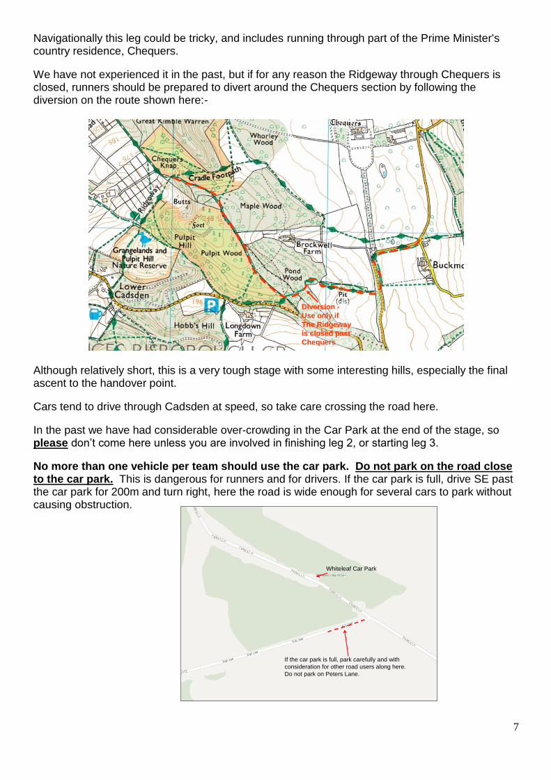
Navigationally this leg could be tricky, and includes running through part of the Prime Minister's country residence, Chequers.
We have not experienced it in the past, but if for any reason the Ridgeway through Chequers is closed, runners should be prepared to divert around the Chequers section by following the diversion on the route shown here:-
Diversion -
Use only if
The Ridgeway
is closed past
Chequers
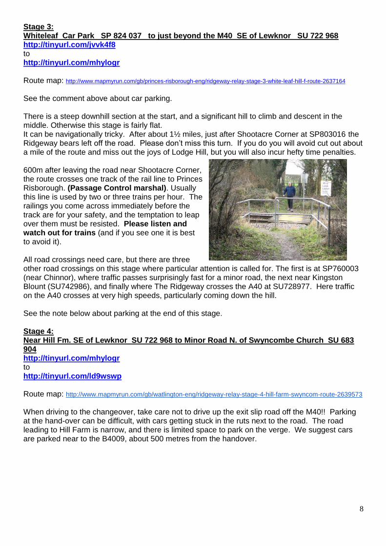
Although relatively short, this is a very tough stage with some interesting hills, especially the final ascent to the handover point.
Cars tend to drive through Cadsden at speed, so take care crossing the road here.
In the past we have had considerable over-crowding in the Car Park at the end of the stage, so please don’t come here unless you are involved in finishing leg 2, or starting leg 3.
No more than one vehicle per team should use the car park. Do not park on the road close to the car park. This is dangerous for runners and for drivers. If the car park is full, drive SE past the car park for 200m and turn right, here the road is wide enough for several cars to park without causing obstruction.
If the car park is full, park carefully and with
consideration for other road users along here.
Do not park on Peters Lane.
Whiteleaf Car Park
8
Stage 3: Whiteleaf Car Park SP 824 037 to just beyond the M40 SE of Lewknor SU 722 968 http://tinyurl.com/jvvk4f8 to http://tinyurl.com/mhylogr Route map: http://www.mapmyrun.com/gb/princes-risborough-eng/ridgeway-relay-stage-3-white-leaf-hill-f-route-2637164
See the comment above about car parking. There is a steep downhill section at the start, and a significant hill to climb and descent in the middle. Otherwise this stage is fairly flat. It can be navigationally tricky. After about 1½ miles, just after Shootacre Corner at SP803016 the Ridgeway bears left off the road. Please don’t miss this turn. If you do you will avoid cut out about a mile of the route and miss out the joys of Lodge Hill, but you will also incur hefty time penalties. 600m after leaving the road near Shootacre Corner, the route crosses one track of the rail line to Princes Risborough. (Passage Control marshal). Usually this line is used by two or three trains per hour. The railings you come across immediately before the track are for your safety, and the temptation to leap over them must be resisted. Please listen and watch out for trains (and if you see one it is best to avoid it). All road crossings need care, but there are three other road crossings on this stage where particular attention is called for. The first is at SP760003 (near Chinnor), where traffic passes surprisingly fast for a minor road, the next near Kingston Blount (SU742986), and finally where The Ridgeway crosses the A40 at SU728977. Here traffic on the A40 crosses at very high speeds, particularly coming down the hill. See the note below about parking at the end of this stage. Stage 4: Near Hill Fm. SE of Lewknor SU 722 968 to Minor Road N. of Swyncombe Church SU 683 904 http://tinyurl.com/mhylogr to http://tinyurl.com/ld9wswp Route map: http://www.mapmyrun.com/gb/watlington-eng/ridgeway-relay-stage-4-hill-farm-swyncom-route-2639573
When driving to the changeover, take care not to drive up the exit slip road off the M40!! Parking at the hand-over can be difficult, with cars getting stuck in the ruts next to the road. The road leading to Hill Farm is narrow, and there is limited space to park on the verge. We suggest cars are parked near to the B4009, about 500 metres from the handover.
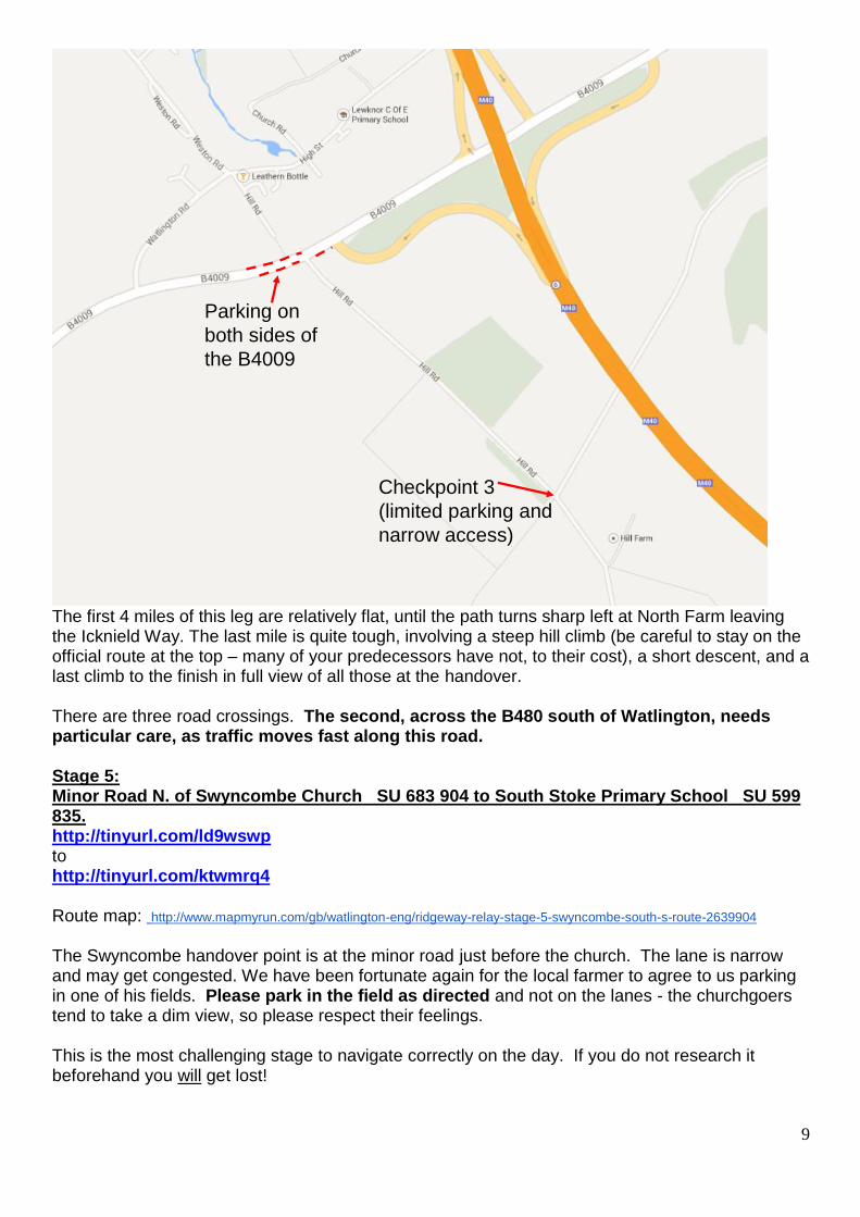
9
Parking on
both sides of
the B4009
Checkpoint 3
(limited parking and
narrow access)
The first 4 miles of this leg are relatively flat, until the path turns sharp left at North Farm leaving the Icknield Way. The last mile is quite tough, involving a steep hill climb (be careful to stay on the official route at the top – many of your predecessors have not, to their cost), a short descent, and a last climb to the finish in full view of all those at the handover. There are three road crossings. The second, across the B480 south of Watlington, needs particular care, as traffic moves fast along this road. Stage 5: Minor Road N. of Swyncombe Church SU 683 904 to South Stoke Primary School SU 599 835. http://tinyurl.com/ld9wswp to http://tinyurl.com/ktwmrq4 Route map: http://www.mapmyrun.com/gb/watlington-eng/ridgeway-relay-stage-5-swyncombe-south-s-route-2639904
The Swyncombe handover point is at the minor road just before the church. The lane is narrow and may get congested. We have been fortunate again for the local farmer to agree to us parking in one of his fields. Please park in the field as directed and not on the lanes - the churchgoers tend to take a dim view, so please respect their feelings. This is the most challenging stage to navigate correctly on the day. If you do not research it beforehand you will get lost!
10
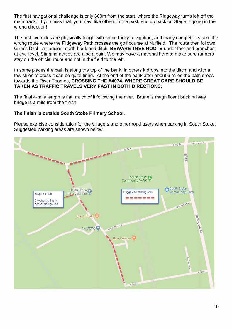
The first navigational challenge is only 600m from the start, where the Ridgeway turns left off the main track. If you miss that, you may, like others in the past, end up back on Stage 4 going in the wrong direction! The first two miles are physically tough with some tricky navigation, and many competitors take the wrong route where the Ridgeway Path crosses the golf course at Nuffield. The route then follows Grim’s Ditch, an ancient earth bank and ditch. BEWARE TREE ROOTS under foot and branches at eye-level. Stinging nettles are also a pain. We may have a marshal here to make sure runners stay on the official route and not in the field to the left. In some places the path is along the top of the bank, in others it drops into the ditch, and with a few stiles to cross it can be quite tiring. At the end of the bank after about 6 miles the path drops towards the River Thames, CROSSING THE A4074, WHERE GREAT CARE SHOULD BE TAKEN AS TRAFFIC TRAVELS VERY FAST IN BOTH DIRECTIONS. The final 4-mile length is flat, much of it following the river. Brunel’s magnificent brick railway bridge is a mile from the finish. The finish is outside South Stoke Primary School. Please exercise consideration for the villagers and other road users when parking in South Stoke. Suggested parking areas are shown below.
11
Stage 6: South Stoke Primary School SU 599 835 to Bury Down Car Park N. of West Ilsley. SU 479 840 http://tinyurl.com/ktwmrq4 to http://tinyurl.com/nxvvush Route map: http://www.mapmyrun.com/gb/goring-eng/ridgeway-relay-stage-6-south-stoke-west-route-2640808 Please exercise consideration for the villagers and other road users when parking. Do not use the Perch and Pike car park unless you are planning to be a customer. We are indebted to Head Teacher, Miss Rogers, for permission to use the South Stoke school playground to set up the check point; the playground can also be used for runners and spectators to keep off the road. Please ensure children do not use any of the school equipment within the playground. For about 2 miles the route is flat, until just after crossing the Thames, but then this becomes a tough stage with a long climb onto the Downs followed by plenty of undulations. As the runners climb out of Goring, they pass the halfway point in the race. Don’t miss the right turn 2½ miles from the end. If you do, you’ll end up in the village of East Ilsley. The finish is 1200m after crossing under the A34 using the underpass. Stage 7: Bury Down Car Park N. of West Ilsley SU 479 840 to Sparsholt Firs Car Park S.W. of Wantage. SU 344 851 http://tinyurl.com/nxvvush to http://tinyurl.com/laglj8y Route map: http://www.mapmyrun.com/gb/harwell-eng/ridgeway-relay-stage-7-west-ilsley-wanta-route-2645794
The first mass start will take place here at 2.00pm for teams who have not arrived at South Stoke by 1.00pm. We don’t want to spoil anyone’s fun, but we do want to get everyone to the finish while the sun is still up. Actual running times will still be recorded for all stages, and the aggregate times calculated. (Note: The mass start here last year was for teams not reaching South Stoke by 1.30pm, but this led to needing an unplanned extra mass start later at Charlbury Hill for several teams that came in just under the deadline at South Stoke.) The start is at a large car park with plenty of space on both sides of the minor road. From here onwards navigation is generally easier and, with one or two exceptions, the hills are less severe. However, this stage is undulating, and tougher than it looks. Please take care on road crossings of the B4494 at SU418842, and the A338 at SU394844, where you turn right onto the main road, followed by a left turn after 100m.
12
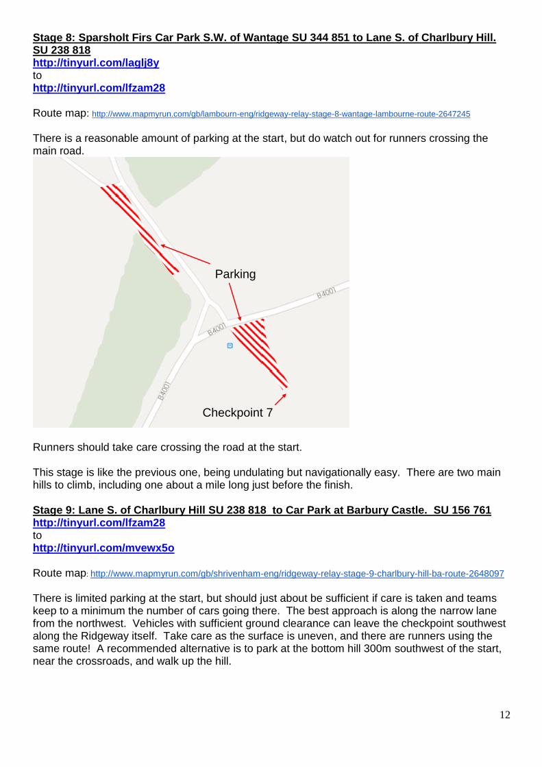
Stage 8: Sparsholt Firs Car Park S.W. of Wantage SU 344 851 to Lane S. of Charlbury Hill. SU 238 818 http://tinyurl.com/laglj8y to http://tinyurl.com/lfzam28 Route map: http://www.mapmyrun.com/gb/lambourn-eng/ridgeway-relay-stage-8-wantage-lambourne-route-2647245
There is a reasonable amount of parking at the start, but do watch out for runners crossing the main road.
Checkpoint 7
Parking
Runners should take care crossing the road at the start. This stage is like the previous one, being undulating but navigationally easy. There are two main hills to climb, including one about a mile long just before the finish. Stage 9: Lane S. of Charlbury Hill SU 238 818 to Car Park at Barbury Castle. SU 156 761 http://tinyurl.com/lfzam28 to http://tinyurl.com/mvewx5o Route map: http://www.mapmyrun.com/gb/shrivenham-eng/ridgeway-relay-stage-9-charlbury-hill-ba-route-2648097 There is limited parking at the start, but should just about be sufficient if care is taken and teams keep to a minimum the number of cars going there. The best approach is along the narrow lane from the northwest. Vehicles with sufficient ground clearance can leave the checkpoint southwest along the Ridgeway itself. Take care as the surface is uneven, and there are runners using the same route! A recommended alternative is to park at the bottom hill 300m southwest of the start, near the crossroads, and walk up the hill.
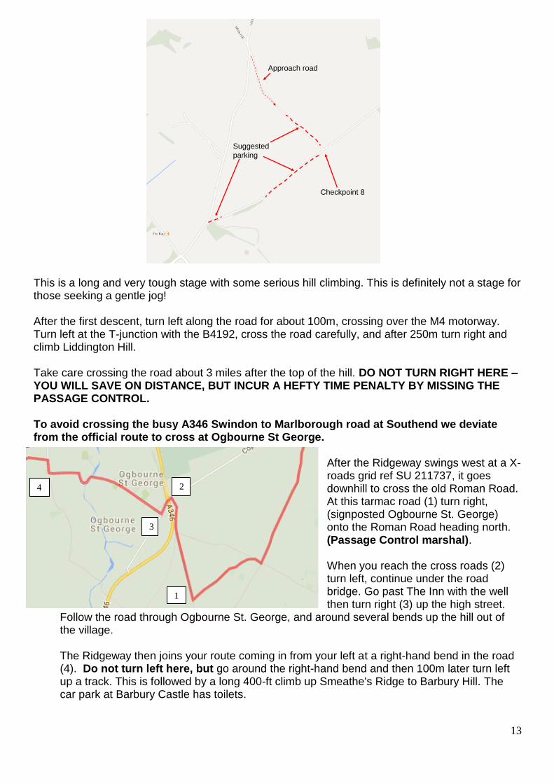
13
Checkpoint 8
Approach road
Suggested
parking
This is a long and very tough stage with some serious hill climbing. This is definitely not a stage for those seeking a gentle jog! After the first descent, turn left along the road for about 100m, crossing over the M4 motorway. Turn left at the T-junction with the B4192, cross the road carefully, and after 250m turn right and climb Liddington Hill. Take care crossing the road about 3 miles after the top of the hill. DO NOT TURN RIGHT HERE – YOU WILL SAVE ON DISTANCE, BUT INCUR A HEFTY TIME PENALTY BY MISSING THE PASSAGE CONTROL. To avoid crossing the busy A346 Swindon to Marlborough road at Southend we deviate from the official route to cross at Ogbourne St George.
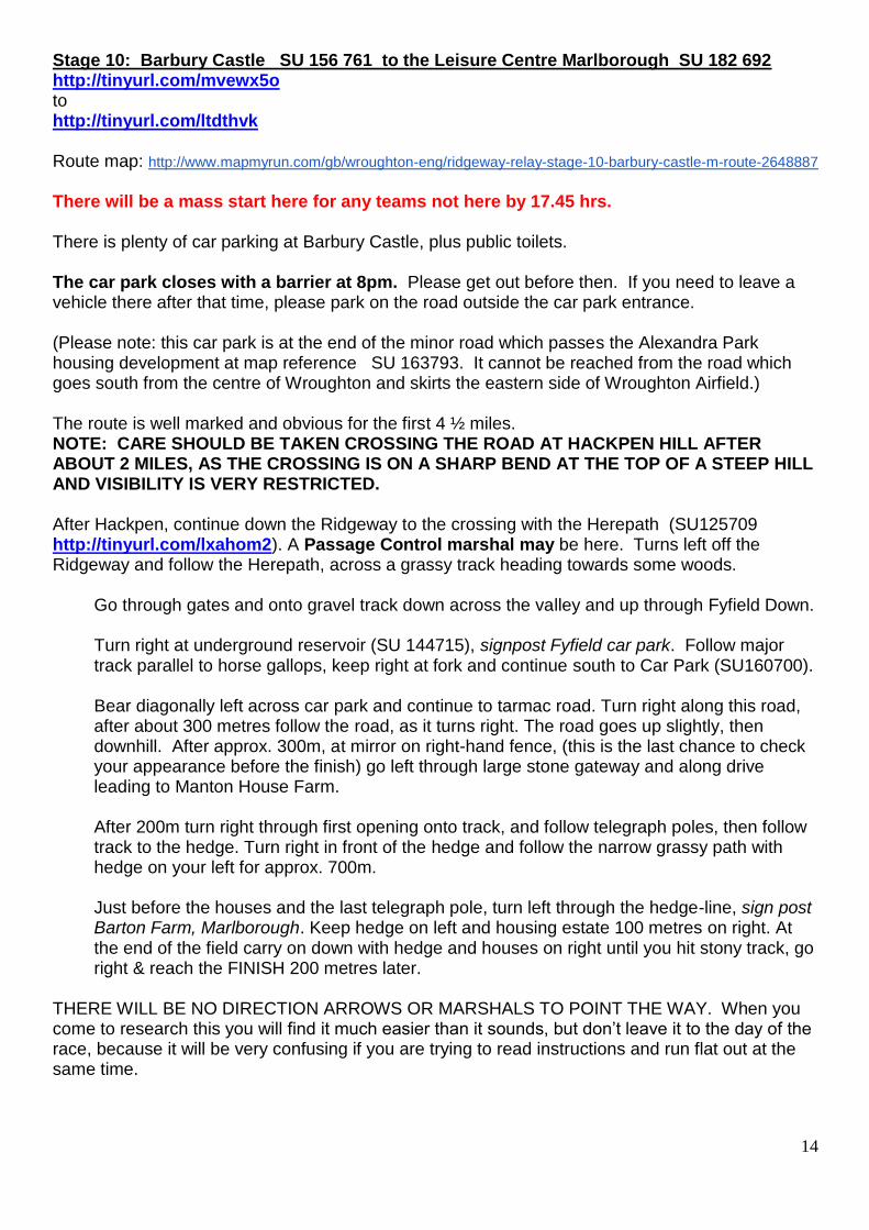
After the Ridgeway swings west at a X-roads grid ref SU 211737, it goes downhill to cross the old Roman Road. At this tarmac road (1) turn right, (signposted Ogbourne St. George) onto the Roman Road heading north. (Passage Control marshal). When you reach the cross roads (2) turn left, continue under the road bridge. Go past The Inn with the well then turn right (3) up the high street.
Follow the road through Ogbourne St. George, and around several bends up the hill out of the village. The Ridgeway then joins your route coming in from your left at a right-hand bend in the road (4). Do not turn left here, but go around the right-hand bend and then 100m later turn left up a track. This is followed by a long 400-ft climb up Smeathe's Ridge to Barbury Hill. The car park at Barbury Castle has toilets.
1
2
3
4
14
Stage 10: Barbury Castle SU 156 761 to the Leisure Centre Marlborough SU 182 692 http://tinyurl.com/mvewx5o to http://tinyurl.com/ltdthvk Route map: http://www.mapmyrun.com/gb/wroughton-eng/ridgeway-relay-stage-10-barbury-castle-m-route-2648887
There will be a mass start here for any teams not here by 17.45 hrs. There is plenty of car parking at Barbury Castle, plus public toilets. The car park closes with a barrier at 8pm. Please get out before then. If you need to leave a vehicle there after that time, please park on the road outside the car park entrance. (Please note: this car park is at the end of the minor road which passes the Alexandra Park housing development at map reference SU 163793. It cannot be reached from the road which goes south from the centre of Wroughton and skirts the eastern side of Wroughton Airfield.) The route is well marked and obvious for the first 4 ½ miles. NOTE: CARE SHOULD BE TAKEN CROSSING THE ROAD AT HACKPEN HILL AFTER ABOUT 2 MILES, AS THE CROSSING IS ON A SHARP BEND AT THE TOP OF A STEEP HILL AND VISIBILITY IS VERY RESTRICTED. After Hackpen, continue down the Ridgeway to the crossing with the Herepath (SU125709 http://tinyurl.com/lxahom2). A Passage Control marshal may be here. Turns left off the Ridgeway and follow the Herepath, across a grassy track heading towards some woods.
Go through gates and onto gravel track down across the valley and up through Fyfield Down. Turn right at underground reservoir (SU 144715), signpost Fyfield car park. Follow major track parallel to horse gallops, keep right at fork and continue south to Car Park (SU160700). Bear diagonally left across car park and continue to tarmac road. Turn right along this road, after about 300 metres follow the road, as it turns right. The road goes up slightly, then downhill. After approx. 300m, at mirror on right-hand fence, (this is the last chance to check your appearance before the finish) go left through large stone gateway and along drive leading to Manton House Farm. After 200m turn right through first opening onto track, and follow telegraph poles, then follow track to the hedge. Turn right in front of the hedge and follow the narrow grassy path with hedge on your left for approx. 700m. Just before the houses and the last telegraph pole, turn left through the hedge-line, sign post Barton Farm, Marlborough. Keep hedge on left and housing estate 100 metres on right. At the end of the field carry on down with hedge and houses on right until you hit stony track, go right & reach the FINISH 200 metres later.
THERE WILL BE NO DIRECTION ARROWS OR MARSHALS TO POINT THE WAY. When you come to research this you will find it much easier than it sounds, but don’t leave it to the day of the race, because it will be very confusing if you are trying to read instructions and run flat out at the same time.
15
Last but not least Just in case of any unforeseen accidents, these are the addresses and telephone numbers of the nearest Accident and Emergency Departments along the route. Aylesbury Stoke Mandeville Hospital 01296 315000 Oxford John Radcliffe Hospital 01865 741166 Swindon Great Western Hospital 01793 604020 Race organiser: Simon 07967 591460 Hugely assisted by: Kirsty 07971 277284 Consultant & Race referee: Alan 07557 682556
16
Ridgeway Relay 10 commandments participant check list
1 Ensure you have recce’d your leg route so there is no chance of taking
a wrong turn and getting lost!
2 Carry a mobile phone (charged) there is a list of emergency numbers on the reverse of your number, just in case.
3 Arrive at the checkpoint at least 10 minutes before your predicted start
time to collect your number.
4 Help the marshals by wearing you club vest and not warming up by running up and down the course at check points.
5 Carry your own water and refreshments as none are provided by MRC.
6 There is no first aid cover provided. Ensure your team has a basic first
aid kit, just in case!
7 There are no toilet facilities at the start or along the route. Public facilities are available in nearby towns and villages.
8 Please car share as much as possible to minimise gridlock at check
points.
9 Beware of road crossings, most are not marshalled. Also the railway
crossing on stage 3.
10 ENJOY THE DAY.