RI DEM Statewide Bacteria TMDL · RHODE ISLAND STATEWIDE TMDL FOR BACTERIA IMPAIRED WATERS...
13
Assessment Unit Facts (RI0007035R-01) Town: Middletown Impaired Segment Length: 4.8 miles Classification: Class AA Direct Watershed: 3.1 mi 2 (1,956 acres) Impervious Cover: 32% Watershed Planning Area: Aquidneck Island (#1) Watershed Land Uses Developed (68%) Non- Developed (12%) Water/ Wetlands (2%) Agriculture (15%) Other (1%) Watershed Description This TMDL applies to the Bailey’s Brook assessment unit (RI0007035R-01), a 4.8-mile long stream located in Middletown, RI (Figure 1). The Town of Middletown is located on Aquidneck Island and Bailey’s Brook is situated in the southern portion of the Island. The Bailey’s Brook watershed is presented in Figure 2 with land use types indicated. Bailey’s Brook has two stream branches flowing southerly to join at North Easton Pond at the southern boundary of the watershed. North Easton Pond is connected to South Easton Pond, which discharges directly to the Atlantic Ocean. North and South Easton Ponds provide drinking water to the residents of Aquidneck Island (Berger, 1999). Due to its location within a drinking water supply, Bailey’s Brook has been designated by RIDEM as a Special Resource Protection Water (SRPW), providing them with special protections under RIDEM’s Antidegradation Provisions. SRPWs are high quality surface waters that have been identified as having significant ecological or recreational uses or are public water supplies. The Bailey’s Brook watershed covers 3.1 square miles and is highly developed, as shown in Figures 2 and 3. Approximately two-thirds (68%) of the Bailey’s Brook watershed is developed land, including the Newport State Airport and other commercial, residential, and transportation land uses. Agricultural uses occupy 15% of the land area. Forests and other non-developed areas occupy 12%, wetland and surface waters occupy 4%, and other land uses combine to occupy 1%. Bailey’s Brook
Transcript of RI DEM Statewide Bacteria TMDL · RHODE ISLAND STATEWIDE TMDL FOR BACTERIA IMPAIRED WATERS...
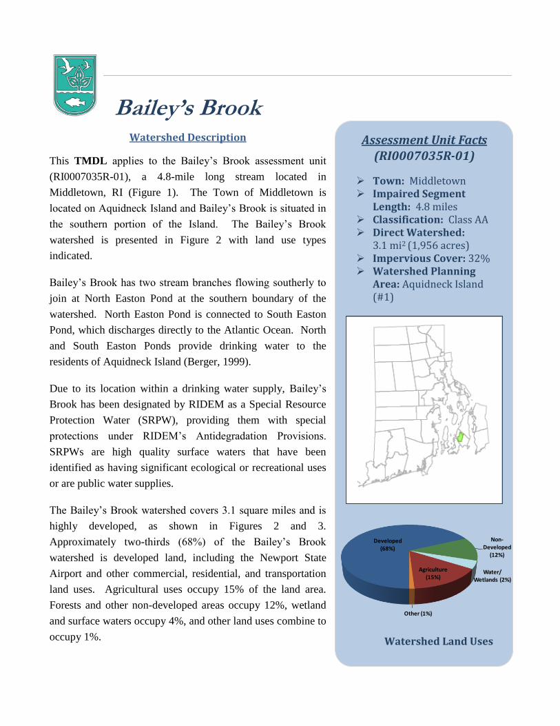
Assessment Unit Facts (RI0007035R-01)
Town: Middletown Impaired Segment
Length: 4.8 miles Classification: Class AA Direct Watershed:
3.1 mi2 (1,956 acres) Impervious Cover: 32% Watershed Planning
Area: Aquidneck Island (#1)
Watershed Land Uses
Developed (68%)
Non-Developed
(12%)
Water/Wetlands (2%)
Agriculture (15%)
Other (1%)
Watershed Description
This TMDL applies to the Bailey’s Brook assessment unit
(RI0007035R-01), a 4.8-mile long stream located in
Middletown, RI (Figure 1). The Town of Middletown is
located on Aquidneck Island and Bailey’s Brook is situated in
the southern portion of the Island. The Bailey’s Brook
watershed is presented in Figure 2 with land use types
indicated.
Bailey’s Brook has two stream branches flowing southerly to
join at North Easton Pond at the southern boundary of the
watershed. North Easton Pond is connected to South Easton
Pond, which discharges directly to the Atlantic Ocean. North
and South Easton Ponds provide drinking water to the
residents of Aquidneck Island (Berger, 1999).
Due to its location within a drinking water supply, Bailey’s
Brook has been designated by RIDEM as a Special Resource
Protection Water (SRPW), providing them with special
protections under RIDEM’s Antidegradation Provisions.
SRPWs are high quality surface waters that have been
identified as having significant ecological or recreational uses
or are public water supplies.
The Bailey’s Brook watershed covers 3.1 square miles and is
highly developed, as shown in Figures 2 and 3.
Approximately two-thirds (68%) of the Bailey’s Brook
watershed is developed land, including the Newport State
Airport and other commercial, residential, and transportation
land uses. Agricultural uses occupy 15% of the land area.
Forests and other non-developed areas occupy 12%, wetland
and surface waters occupy 4%, and other land uses combine to
occupy 1%.
Bailey’s Brook
RHODE ISLAND STATEWIDE TMDL FOR BACTERIA IMPAIRED WATERS SEPTEMBER 2011
BAILEY’S BROOK WATERSHED SUMMARY
2
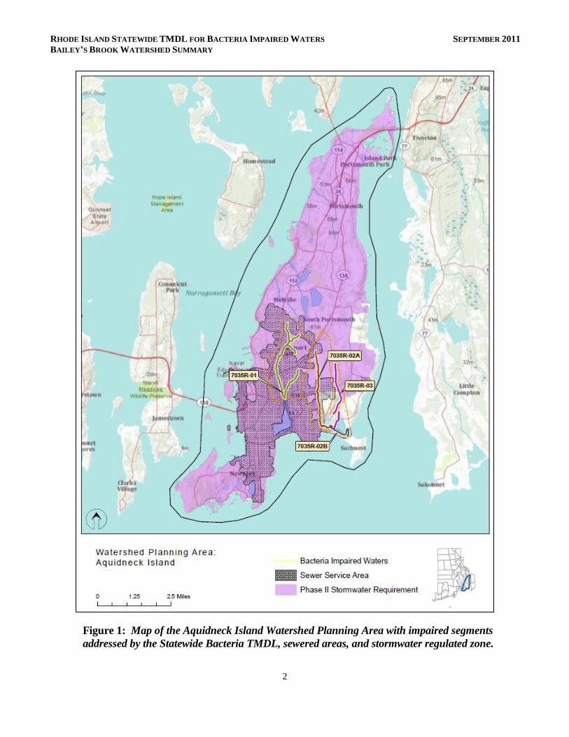
Figure 1: Map of the Aquidneck Island Watershed Planning Area with impaired segments
addressed by the Statewide Bacteria TMDL, sewered areas, and stormwater regulated zone.

RHODE ISLAND STATEWIDE TMDL FOR BACTERIA IMPAIRED WATERS SEPTEMBER 2011
BAILEY’S BROOK WATERSHED SUMMARY
3
Figure 2: Map of Bailey’s Brook watershed with impaired segment, sampling locations,
and land cover indicated.

RHODE ISLAND STATEWIDE TMDL FOR BACTERIA IMPAIRED WATERS SEPTEMBER 2011
BAILEY’S BROOK WATERSHED SUMMARY
4
Figure 3: Partial aerial view
of Bailey’s Brook watershed.
(Source: Bing Maps)
Why is a TMDL Needed?
Bailey’s Brook is a Class AA fresh water stream and is a tributary
within the Newport public drinking water supply system.
However, as it is not a terminal reservoir, its applicable designated
uses are primary and secondary contact recreation (RIDEM,
2009). During 2006-2008, water samples were collected from
three sampling locations (WW407, WW408, and WW409) and
analyzed for the indicator bacteria, enterococci. The water quality
criteria for enterococci, along with bacteria sampling results from
the 2006-2008 study and associated statistics are presented in
Table 1. During all years sampled and at all three sampling
locations, the geometric mean statistical metric for these data
exceeded the water quality criteria value.
To aid in identifying possible bacteria sources, the geometric
mean was also calculated for each station for wet-weather and
dry-weather sampling days, where appropriate. Both wet and dry
geometric mean values exceeded the water quality criteria for
enterococci, with the dry-weather statistics higher than the wet-
weather statistics.
Due to the elevated bacteria measurements presented in Table 1,
the Bailey’s Brook assessment unit was identified as impaired and
was placed on the 303(d) list (RIDEM, 2008). The Clean Water
Act requires that all 303(d) listed waters undergo a TMDL
assessment that describes the impairments and identifies the
measures needed to restore water quality. The goal is for all
waterbodies to comply with state water quality standards.
Bailey’s Brook has also been assessed by RIDEM as not meeting
water quality standards for biodiversity and lead, though no
TMDLs have been completed for these impairments. North Easton Pond, a pond fed by Bailey’s Brook,
has been assessed as impaired for phosphorus and is included in the 2007 Eutrophic Ponds Phosphorus
TMDL (RIDEM, 2007). Bailey’s Brook is recognized as a significant source of phosphorus to North
Easton Pond. The approved Eutrophic Ponds TMDL triggered the Part IV.D stormwater requirements
that are discussed in Section 6.2 of the Core TMDL Document. Implementation activities include
identifying priority outfalls that discharge to North Easton Pond and its tributaries, including Bailey’s
Brook, as well as constructing structural BMPs.

RHODE ISLAND STATEWIDE TMDL FOR BACTERIA IMPAIRED WATERS SEPTEMBER 2011
BAILEY’S BROOK WATERSHED SUMMARY
5
Potential Bacteria Sources
Previous investigations have concluded that there are several potential sources of harmful bacteria in the
Bailey’s Brook watershed including stormwater runoff from developed areas, illicit discharges, and
agricultural activities. A stream buffer survey found that 34% of the stream buffer was under high-
intensity land use (Geosyntec, 2005). Intensive land use near the brook is likely to result in increased
adverse impacts because the natural land buffering system of the stream has been removed. Each type
of potential bacteria sources is described briefly below.
Developed Area Stormwater Runoff
The Bailey’s Brook watershed has an impervious cover of 32%. Impervious cover is defined as land
surface areas, such as roofs and roads that force water to run off land surfaces, rather than infiltrating
into the soil. Impervious cover provides a useful metric for the potential for adverse stormwater
impacts. Based on the Bailey’s Brook watershed imperviousness, adverse stormwater impacts to the
receiving stream appear likely. As discussed in Section 6.3 of the Core TMDL Document, as a general
rule, impaired streams with watersheds having more than 10% impervious cover are assumed to be
impacted by stormwater runoff. Soils in the watershed are 98% hydrologic group “C”, characterized as
slowly permeable and having a hardpan layer that restricts infiltration (Geosyntec, 2005).
As shown in Figure 2, five Rhode Island Department of Transportation (RIDOT) stormwater outfalls1
have been identified in the Bailey’s Brook watershed, with multiple outfalls directly on the brook. A
watershed management plan was developed for Bailey’s Brook and identified numerous locations where
stormwater runoff was directly connected to the brook (Geosyntec, 2005). In the 2007 Eutrophic Ponds
Phosphorus TMDL, these stormwater outfalls were also considered to contribute large amounts of
phosphorus to Bailey’s Brook, resulting in high concentrations in North Easton Pond (RIDEM, 2007).
As stormwater is known to carry a suite of pollutants other than phosphorus, these locations are likely
sources of bacteria to Bailey’s Brook.
Onsite Wastewater Treatment Systems
Bailey’s Brook is mostly sewered, but also relies partially on onsite wastewater treatment systems
(OWTS) (i.e., septic systems). Failing OWTS can be significant sources of bacteria by allowing raw
waste to reach surface waters (RI HEALTH, 2003). As shown in Figure 2, no OWTS Notices of
Violation/Notices of Intent to Violate (NOV/NOIs) have been issued by the RIDEM Office of
Compliance and Inspection in the Bailey’s Brook watershed.
1 Note that additional outfalls discharge to the waterbody.
RHODE ISLAND STATEWIDE TMDL FOR BACTERIA IMPAIRED WATERS SEPTEMBER 2011
BAILEY’S BROOK WATERSHED SUMMARY
6
Sewer Leaks
Sewer system leaks and other illicit discharges have historically been reported in Bailey’s Brook
(Berger, 2008). In 2005, an interceptor sewer line that runs along Bailey’s Brook was observed to be
overflowing at multiple locations, causing a surge of wastewater from sewer manholes in very close
proximity to the stream. Other areas along the sewer line had reports of odors and organic growth,
indicating leaking. In 2007, the Town of Middletown inspected the sewer line and repaired the
manholes and manhole connections. To date, no additional leaks have been reported in this particular
sewer line (RIDEM, 2007). In 2010, three sewage discharges were reported in the vicinity of Bailey’s
Brook. In response to the unprecedented rainfall amount at the end of March, a manhole on Griffin
Avenue surcharged. Debris and grease led to bypass on O’Neill Boulevard in May and on Haymaker
Road in October. Dry weather sampling results show that Bailey’s Brook continues to have elevated
bacteria levels, suggesting the potential for additional leaks, illicit discharges, and/or failing OWTS
(Table 1).
Agricultural Activities
Agricultural operations are an important economic activity and landscape feature in many areas of the
state. Rhode Island Nursery is one of the largest agricultural operations in the Bailey’s Brook watershed
(Geosyntec, 2005). The Nursery has been suspected of contributing phosphorus from agricultural runoff
to Bailey’s Brook and North Easton Pond from two separate nursery operations (RIDEM, 2007).
Agricultural runoff may contain other pollutants, such as bacteria. As agricultural land use makes up
15% of the Bailey’s Brook watershed, agricultural runoff is a potential source of bacteria to Bailey’s
Brook.
Waterfowl, Wildlife, and Domestic Animal Waste
Waterfowl, wildlife, and domestic animals within the Bailey’s Brook watershed represent another
potential source of bacteria. Wildlife, including waterfowl, may be a significant bacteria source to
surface waters. With the construction of roads and drainage systems, these wastes may no longer be
retained on the landscape, but instead may be conveyed via stormwater to the nearest surface water. As
such these physical land alterations can exacerbate the impact of these natural sources on water quality.
Existing Local Management and Recommended Next Steps
The Town of Middletown has developed and implemented programs to protect water quality from
bacterial contamination. Future mitigative activities are necessary to ensure the long-term protection of
Bailey’s Brook. The existing watershed management plan (Geosyntec, 2005) and the Eutrophic Ponds
Phosphorus TMDL (RIDEM, 2007) provide a strong technical basis for beginning to reduce a suite of
pollutants, including bacteria. A brief description of existing local programs and recommended next

RHODE ISLAND STATEWIDE TMDL FOR BACTERIA IMPAIRED WATERS SEPTEMBER 2011
BAILEY’S BROOK WATERSHED SUMMARY
7
steps from the watershed management plan, the TMDL, a stormwater phase II report, a source water
assessment, and other documents are provided below. Stakeholders should review these documents
directly for more detailed information.
Stormwater Management
The Town of Middletown (RIPDES permit RIR040032) and the Rhode Island Department of
Transportation (RIDOT) (RIPDES permit RIR040036) are municipal separate storm sewer system
(MS4) operators in the Bailey’s Brook watershed and both have prepared the required Phase II
Stormwater Management Plans (SWMPP). The entire watershed is regulated under the Phase II
program. Middletown’s SWMPP (2008) outlines the goals for the reduction of stormwater runoff to
Bailey’s Brook through the implementation of Best Management Practices (BMPs). Many of these
BMPs are now in place, including mapping all stormwater outfalls, instituting annual inspections and
cleaning of the town’s 1400 catch basins, implementing an annual street sweeping program, adopting
construction erosion and sediment control and post-construction stormwater ordinances, and conducting
public education activities (RIDEM, 2010a).
In 2006, the Town of Middletown adopted an illicit discharge detection and elimination ordinance,
based on the model ordinance developed by the Center for Watershed Protection (Berger, 2008). This
ordinance prohibits illicit discharges to the MS4 and provides an enforcement mechanism. The Town
should continue to locate priority areas to identify and eliminate illicit discharges in the Bailey’s Brook
watershed (Geosyntec, 2005; Berger, 2008). Illicit discharges can be identified through continued dry
weather outfall sampling and microbial source tracking.
RIDOT has completed a SWMPP for state-owned roads in the watershed. RIDOT’s SWMPP and its
2011 Compliance Update outline its goals for compliance with the General Permit statewide. It should
be noted that RIDOT has chosen to enact the General Permit statewide, not just for the urbanized and
densely populated areas that are required by the permit. RIDOT has finished mapping its outfalls
throughout the state and is working to better document and expand its catch basin inspection and
maintenance programs along with its BMP maintenance program. Stormwater Pollution Prevention
Plans (SWPPP) are being utilized for RIDOT construction projects. RIDOT also funds the University of
Rhode Island Cooperative Extension’s Stormwater Phase II Public Outreach and Education Project,
which provides participating MS4s with education and outreach programs that can be used to address
TMDL public education recommendations.
While these first steps are important to reduce the effects of stormwater runoff to Bailey’s Brook,
additional efforts are needed to restore the river’s water quality. As mentioned previously, the Bailey’s
Brook watershed has an impervious cover of 32%, a level where stormwater impacts are expected. At
this threshold, RIDEM is requiring the MS4 operators to revise their post-construction ordinances and

RHODE ISLAND STATEWIDE TMDL FOR BACTERIA IMPAIRED WATERS SEPTEMBER 2011
BAILEY’S BROOK WATERSHED SUMMARY
8
evaluate whether the six minimum measures alone are sufficient to meet the bacteria reduction targets.
Per Part IV.D of the General Permit, the MS4 operators should ensure that their minimum measures are
consistent with the recommendation of Section 6.2 of the Core TMDL Document. This includes
ensuring that their post-construction ordinances are consistent with Section 6.2
Changes to the SWMPP should be documented in a TMDL Implementation Plan (TMDL IP) and should
comply with the relevant provisions of Part IV.D of the RIPDES Stormwater General Permit (RIDEM,
2010b), which are summarized in Section 6.1 (Numbers 1-5) of the Core TMDL Document. Further
detail is also included in Sections 6.3 of the Core TMDL Document. In addition, the 2007 Eutrophic
Ponds TMDL required that the Town of Middletown and the RIDOT develop and implement
appropriate infiltration, filtration, and/or retention BMPs to reduce the stormwater runoff volume to
Bailey’s Brook to reduce phosphorus loads to North Easton Pond (RIDEM, 2007). These BMPs must
also target bacteria pollution as well. Conceptual stormwater BMP designs for several sites are provided
in the 2005 Watershed Management Plan (Geosyntec, 2005). These BMPs would disconnect
impervious areas and reduce pollutant loads to the Brook. One TMDL IP may be submitted to address
both bacteria and phosphorus TMDL requirements.
The Town of Middletown should also continue to implement the goals of its Phase II Stormwater
Management Plan (2008) including dry weather sampling, extensive street and catch basin cleaning
programs, and public education activities (Berger, 2008). RIDOT should also continue to implement its
Phase II Stormwater Management Plan.
Onsite Wastewater Management
Though the majority of the Bailey’s Brook watershed is sewered, a portion of the watershed relies on
OWTS. Currently, the Town of Middletown does not have an Onsite Wastewater Management Plan.
As part of an onsite wastewater planning process, Middletown should adopt ordinances to establish
enforceable mechanisms to ensure that existing OWTS are properly operated and maintained. RIDEM
recommends that communities create an inventory of OWTS through mandatory inspections.
Inspections help encourage proper maintenance and identify failed and sub-standard systems. Policies
that govern the eventual replacement of sub-standard OWTS and cesspools within a reasonable time
frame should be adopted. The Rhode Island Wastewater Information Systems (RIWIS) can help
develop an initial inventory of OWTS and can track voluntary inspection and pumping programs
(RIDEM, 2010b).
The Town of Middletown is not eligible for the Community Septic System Loan Program (CSSLP).
The CSSLP program provides low-interest loans to residents to help with maintenance and replacement
of OWTS. It is recommended that the town develop a program to assist citizens with the replacement of
older and failing systems.

RHODE ISLAND STATEWIDE TMDL FOR BACTERIA IMPAIRED WATERS SEPTEMBER 2011
BAILEY’S BROOK WATERSHED SUMMARY
9
Sewer Leaks
As noted previously, the Town of Middletown inspected and repaired the interceptor sewer line that runs
along Bailey’s Brook in 2007. While no additional leaks have been reported in this particular sewer
line, it is important for the town to conduct inspections and follow-up on observations (RIDEM, 2007).
The Town of Middletown should also implement a program to evaluate its sanitary sewer and reduce
leaks and overflows (Berger, 2008).
Agricultural Activities
If not already in place, agricultural producers should work with the RIDEM Division of Agriculture and
the U.S. Department of Agriculture Natural Resources Conservation Service (NRCS) to develop
conservation plans for their farming activities within the watershed. NRCS and RIDEM Division of
Agriculture should continue to work with Rhode Island Nursery and other agricultural operations in the
watershed to ensure that there are sufficient stream buffers, that fencing exists to restrict access of
livestock and horses to streams and wetlands, and that animal waste handling, disposal, and other
appropriate BMPs are in place.
Waterfowl, Wildlife, and Domestic Animal Waste
Middletown’s education and outreach programs should highlight the importance of picking up after
horses, dogs, and other pets and not feeding waterfowl, particularly in the lower portion of the
watershed. Animal wastes should be disposed of away from any waterway or stormwater system.
Middletown should work with volunteers from the town to map locations where animal waste is a
significant and chronic problem. This work should be incorporated into the municipalities’ Phase II
plans and should result in an evaluation of strategies to reduce the impact of animal waste on water
quality. This may include installing signage, providing pet waste receptacles or pet waste digester
systems in high-use areas, enacting ordinances requiring clean-up of pet waste, and targeting educational
and outreach programs in problem areas.
The town and residents can take several measures to minimize waterfowl-related impacts. They can
allow tall, coarse vegetation to grow in areas along the shores of the Bailey’s Brook that are frequented
by waterfowl. Waterfowl, especially grazers like geese, prefer easy access to the water. Maintaining an
uncut vegetated buffer along the shore will make the habitat less desirable to geese and encourage
migration. With few exceptions, Part XIV, Section 14.13, of Rhode Island’s Hunting Regulations
prohibits feeding wild waterfowl at any time in the state of Rhode Island. Educational programs should
emphasize that feeding waterfowl, such as ducks, geese, and swans, may contribute to water quality
impairments in the Bailey’s Brook and can harm human health and the environment. Middletown
should ensure that discussion of this regulation is included in their SWMPPs.

RHODE ISLAND STATEWIDE TMDL FOR BACTERIA IMPAIRED WATERS SEPTEMBER 2011
BAILEY’S BROOK WATERSHED SUMMARY
10
Land Use Protection
Currently, the Bailey’s Brook watershed is approximately 16% undeveloped (RI HEALTH, 2003) and
only a small portion is protected as open space. As source waters to Newport’s water supply, preserving
these natural areas is particularly important. Woodland and wetland areas within the Bailey’s Brook
watershed absorb and filter pollutants from stormwater and agricultural runoff, and help protect both
water quality in the stream and stream channel stability. It is important to preserve these undeveloped
areas, and institute controls on development in Bailey’s Brook watershed (RI HEALTH, 2003).
The steps outlined above will support the goal of mitigating bacteria sources and meeting water quality
standards in Bailey’s Brook.

RHODE ISLAND STATEWIDE TMDL FOR BACTERIA IMPAIRED WATERS SEPTEMBER 2011
BAILEY’S BROOK WATERSHED SUMMARY
11
Table 1: Bailey’s Brook Bacteria Data
Waterbody ID: RI0007035R-01
Watershed Planning Area: 1 – Aquidneck Island
Characteristics: Freshwater, Class AA, Tributary within a Public Drinking Supply, Primary and
Secondary Contact Recreation, Special Resource Protection Water (SRPW)
Impairment: Enterococci (colonies/100mL)
Water Quality Criteria for Enterococci: Geometric Mean: 54 colonies/100 mL
Percent Reduction to meet TMDL: 97% (Includes 5% Margin of Safety)
Data: 2006-2008 from RIDEM
Single Sample Enterococci (colonies/100 mL) Results for Bailey’s Brook (2006-2008) with
Geometric Mean Statistics
Station Name Station Location Date Result Wet/Dry Geometric
Mean
WW408 Bailey’s Brook (SRU - 1) 10/25/2008 63 Dry
241
WW408 Bailey’s Brook (SRU - 1) 9/20/2008 816 Dry
WW408 Bailey’s Brook (SRU - 1) 8/19/2008 517 Dry
WW408 Bailey’s Brook (SRU - 1) 7/12/2008 3226 Dry
WW408 Bailey’s Brook (SRU - 1) 6/4/2008 88 Wet
WW408 Bailey’s Brook (SRU - 1) 5/9/2008 26 Wet
WW408 Bailey’s Brook (SRU - 1) 10/20/2007 983 Wet
180
WW408 Bailey’s Brook (SRU - 1) 9/15/2007 9804 Dry
WW408 Bailey’s Brook (SRU - 1) 8/21/2007 980 Dry
WW408 Bailey’s Brook (SRU - 1) 7/21/2007 62 Dry
WW408 Bailey’s Brook (SRU - 1) 6/16/2007 10 Dry
WW408 Bailey’s Brook (SRU - 1) 5/11/2007 6 Dry
WW407 Bailey’s Brook (Market) 10/25/2008 24 Dry
186
WW407 Bailey’s Brook (Market) 9/20/2008 221 Dry
WW407 Bailey’s Brook (Market) 8/15/2008 1414 Wet
WW407 Bailey’s Brook (Market) 7/11/2008 245 Dry
WW407 Bailey’s Brook (Market) 6/7/2008 176 Dry
WW407 Bailey’s Brook (Market) 5/10/2008 130 Wet

RHODE ISLAND STATEWIDE TMDL FOR BACTERIA IMPAIRED WATERS SEPTEMBER 2011
BAILEY’S BROOK WATERSHED SUMMARY
12
Single Sample Enterococci (colonies/100 mL) Results for Baileys Brook (2006-2008) with
Geometric Mean Statistics (continued)
Station Name Station Location Date Result Wet/Dry Geometric
Mean
WW407 Bailey’s Brook (Market) 10/20/2007 294 Wet
713†
(97%)*
WW407 Bailey’s Brook (Market) 9/15/2007 9678 Dry
WW407 Bailey’s Brook (Market) 8/18/2007 626 Dry
WW407 Bailey’s Brook (Market) 7/20/2007 1203 Dry
WW407 Bailey’s Brook (Market) 6/15/2007 488 Dry
WW407 Bailey’s Brook (Market) 5/12/2007 126 Dry
WW407 Bailey’s Brook (Market) 10/28/2006 5 Wet
84
WW407 Bailey’s Brook (Market) 9/30/2006 197 Wet
WW407 Bailey’s Brook (Market) 8/26/2006 517 Wet
WW407 Bailey’s Brook (Market) 7/29/2006 613 Dry
WW407 Bailey’s Brook (Market) 5/20/2006 13 Wet
WW409 Bailey’s Brook (SRU - 2) 10/25/2008 44 Dry
134
WW409 Bailey’s Brook (SRU - 2) 9/20/2008 373 Dry
WW409 Bailey’s Brook (SRU - 2) 8/19/2008 249 Dry
WW409 Bailey’s Brook (SRU - 2) 7/12/2008 1664 Dry
WW409 Bailey’s Brook (SRU - 2) 6/4/2008 44 Wet
WW409 Bailey’s Brook (SRU - 2) 5/9/2008 20 Wet
WW409 Bailey’s Brook (SRU - 2) 10/20/2007 364 Wet
262
WW409 Bailey’s Brook (SRU - 2) 9/15/2007 2178 Dry
WW409 Bailey’s Brook (SRU - 2) 8/21/2007 1203 Dry
WW409 Bailey’s Brook (SRU - 2) 7/21/2007 64 Dry
WW409 Bailey’s Brook (SRU - 2) 6/16/2007 548 Dry
WW409 Bailey’s Brook (SRU - 2) 5/11/2007 10 Dry
Shaded cells indicate an exceedance of water quality criteria
*Includes 5% Margin of Safety † Geometric mean used to determine percent reduction
Wet and Dry Weather Geometric Mean Enterococci Values for each Station
Station
Name Station Location
Years
Sampled
Number of Samples Geometric Mean
Wet Dry All Wet Dry
WW408 Bailey’s Brook (SRU - 1) 2007-2008 3 9 208 130 243
WW407 Bailey’s Brook (Market) 2006-2008 7 10 236 120 380
WW409 Bailey’s Brook (SRU - 2) 2007-2008 3 9 187 68 263
Shaded cells indicate an exceedance of water quality criteria
Weather condition determined from rain gage at Newport County Airport in Middletown, RI

RHODE ISLAND STATEWIDE TMDL FOR BACTERIA IMPAIRED WATERS SEPTEMBER 2011
BAILEY’S BROOK WATERSHED SUMMARY
13
References
Berger (1999). Wastewater Facilities Plan: Town of Middletown, Rhode Island. Submitted by Louis
Berger & Associates, Inc, Providence, RI. January 1999.
Berger (2006). Wastewater Management Plan Update for Town of Middletown, Rhode Island.
Submitted to Public Works Department, Town of Middletown; Submitted by The Louis Berger
Group, Inc, Providence, RI. March 8, 2002 (Revised March 2006)
Berger (2008). Phase II Stormwater Management Plan Wastewater Management Plan: Town of
Middletown, Rhode Island. Submitted by The Louis Berger Group, Inc, Providence, RI.
December 2003, Updated May 2008.
Geosyntec (2005). Bailey Brook Watershed Plan: Preliminary Investigation. Prepared for NRSC,
Warwick, RI; Prepared by Geosyntec Consultants, Acton, MA. July 2005.
RIDEM (2007). Total Maximum Daily Loads for Phosphorus to Address 9 Eutrophic Ponds in Rhode
Island. Rhode Island Department of Environmental Management.
RIDEM (2008). State of Rhode Island and Providence Plantations 2008 303(d) List – List of Impaired
Water Bodies. Rhode Island Department of Environmental Management.
RIDEM (2009). State of Rhode Island and Providence Plantations Water Quality Regulations. Amended
December, 2009. Rhode Island Department of Environmental Management.
RIDEM (2010a). MS4 Compliance Status Report for RI Statewide Bacteria TMDL. Rhode Island
Department of Environmental Management.
RIDEM (2010b). Total Maximum Daily Load Analysis for the Pawcatuck River and Little Narragansett
Bay Waters (Bacteria Impairments. Rhode Island Department of Environmental Management.
RI HEALTH (2003). Aquidneck Island Drinking Water Assessment Results, Source Water Protection
Assessment conducted by the University of Rhode Island for the Rhode Island Department of
Health, Office of Drinking Water Quality.