Comprehensive District Education Plan Rhinebeck Central School District State of NY
Rhinebeck: Transition in 1799 by Nancy V. Kelly
Valuable tax rolls filed in 1799 were recently discovered when the State Treasurer's office turned over some boxes of early documents to the New York State Archives. Coupled with the existence of detailed maps of the Town of
Rhinebeck, prepared in 1798, they offer an unusual opportunity to study the conditions which existed in Rhinebeck at the end of the 18th century. While the 17th century had been characterized by settlement and the establishment of communities, the following would be a time of agricultural prosperity and economic development. The transition between the two periods offers useful insights into the past.
The tax list enables one to observe the economic status of Rhinebeck residents via brief descriptions of their property. This information, augmented by the maps drawn by surveyor Alexander Thompson, locate many of the larger estates, as well as the inns, landings, and mills which played an important role in the social and economic conditions in the town.
Tax rolls were prepared in conjunction with a bill which was passed in the New York State Legislature in 1798, requiring that all freemen be assessed for both personal and real property and then taxed at the rate of one percent. Although most census and earlier tax lists were prepared according to the area in which an individual was living, indicating neighboring property holders and providing a
70 The Hudson Valley Regional Review, March 1989, Volume 6, Number 2
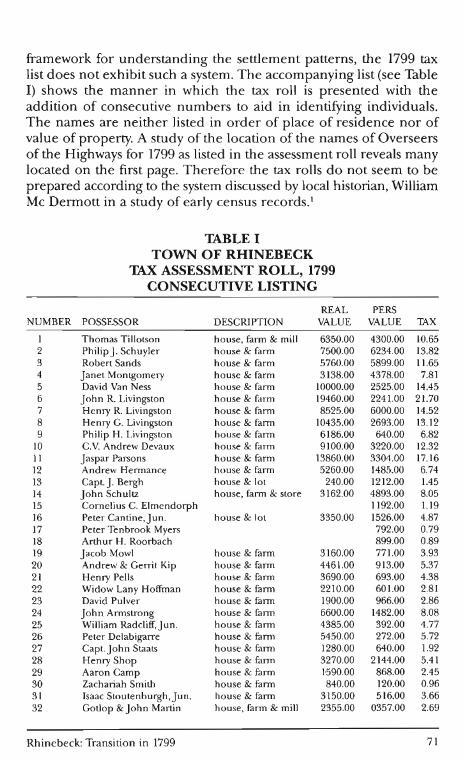
framework for understanding the settlement patterns, the 1799 tax list does not exhibit such a system . Th e accompanying list (see Table I) sh ows the manner in which the tax roll is presented with the addition of consecutive numbers to aid in iden tifYing individuals. The names are neither listed in order of p lace of residence nor of value of property. A study of the location of the names of Overseers of the H ighways for 1799 as listed in the assessment roll reveals many located on the firs t page. Therefore the tax rolls do not seem to be prepared according to the system d iscussed by local historian, William Mc Dermott in a study of early census records.l
TABLE I TOWN OF RHINEBECK
'D\X ASSESSMENT ROLL, 1799 CONSECUTIVE LISTING
REAL PERS NUMBER POSSESSOR DESCRIPTION VALUE VALUE lAX
1 Thomas Tillotson house, farm & mill 6350.00 4300.00 10.65 2 Philip J. Schuyler house & farm 7500.00 6234.00 13.82 3 Robert Sands house & farm 5760.00 5899.00 11.65 4 janet Montgomery house & farm 3138.00 4378.00 7.81 5 David Van Ness house & farm 10000.00 2525.00 14.45 6 john R. Livingston house & farm 19460.00 2241.00 21.70 7 Henry R. Livingston house & farm 8525.00 6000.00 14.52 8 Henry G. Livingston house & farm 10435.00 2693.00 13.12 9 Philip H. Livingston house & farm 6186.00 640.00 6.82
10 c.v. Andrew Devaux house & farm 9100.00 3220.00 12.32 II jaspar Parsons house & farm 13860.00 3304.00 17.16 12 Andrew Hermance house & farm 5260.00 1485.00 6.74 13 Capt. J. Bergh house & lot 240.00 1212.00 1.45 14 john Schultz house, farm & store 3162.00 4893.00 8.05 15 Cornelius C. Elmendorph 1192.00 1.19 16 Peter Cantine,jun. house & lot 3350.00 1526.00 4.87 17 Peter Tenbrook Myers 792.00 0.79 18 Arthur H. Roorbach 899.00 0.89 19 jacob Mowl house & farm 3160.00 771.00 3.93 20 Andrew & Gerrit Kip house & farm 4461.00 913.00 5.37 21 Henry Pells house & farm 3690.00 693.00 4.38 22 Widow Lany Hoffman house & farm 2210.00 601.00 2.81 23 David Pulver house & farm 1900.00 966.00 2.86 24 john Armstrong house & farm 6600.00 1482.00 8.08 25 Wi ll iam Radcliff,jun. house & farm 4385.00 392.00 4.77 26 Peter Delabigarre house & farm 5450.00 272.00 5.72 27 Capt. john Staats house & farm 1280.00 640.00 1.92 28 Henry Shop house & farm 3270.00 2144.00 5.41 29 Aaron Camp house & farm 1'590.00 868.00 2.45 30 Zachariah Smith house & farm 840.00 120.00 0.96 31 Isaac Stoutenburgh,jun. house & farm 3150.00 516.00 3.66 32 Gotlop &john Martin house, farm & mill 2355.00 0357.00 2.69
Rhinebeck: Transition in 1799 71
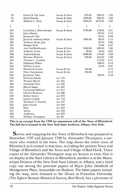
33 Garret B. Van Ness house & farm 870.00 390.00 1.26 34 David Brooks house & farm 1550.00 282.00 1.83 35 Richard C. Ham house & farm 1850.00 1672.00 3.52
l l l l l l 530 Cornelius J. Elmendorph house & farm 4792.00 518.00 5.31 53 1 J ohn Masten 192.00 0.19 532 J eremyah Nier 85.00 0.08 533 Jacob & Anthony Straat house & farm 1060.00 82.00 1.14 534 Anthony Straat, Jun. 64.00 0.06 535 Margret Pink 74.00 0.07 536 Ann VanBenthuysen house & farm 1060.00 608.00 1.66 537 Anthony Lewis house & lott 30.00 40.00 0.07 538 Anthony.Straat house & farm 3080.00 218.00 3.29 539 Herman Wi tbeck house & farm 720.00 364.00 1.08 540 Thomas L. Cumbie 4 12.00 0.41 541 Nathaniel Miller 188.00 0.18 542 William Currie 42.00 0.04 543 Hendrick Clumb house & lott 130.00 0.1 3 544 Peter Heermance house & lott 130.00 0.13 545 Jeremyah Tator 180.00 0.1 8 546 Nicholas Stickle see 170 547 Thomas Harris see 355 548 Zachariah Nier see 362 549 Barent Staats see 367 550 Coonrand Millham see 217 55 1 Charles Rynhaut see 366 552 Robert Sands see 273 553 Joshua Collins see 116 554 Abraham V. Voorhis see 107 555 J ohn Snook see 344 556 Hart see 339 557 Taylor see 339 558 Anderson see 339 559 William Thompson see 58
This is an excerpt from the 1799 tax assessment roll of the Town of Rhinebeck. The full list is located in the New York State Archives, Albany, New York.
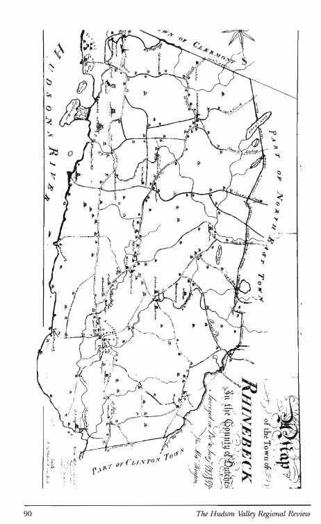
Survey and mapping for the Town of Rhinebeck was prepared in December 1797 and January 1798 by Alexander Thompson, a surveyor who resided in the town. The map shows the entire town of Rhinebeck as it existed at that time, including the present Town and Village of Rhinebeck and the Town and Village of Red Hook. Three copies of the Alexander Thompson map are known to exist. One is on display at the Starr Library in Rhinebeck, another is at the Manuscripts Division of the New York State Library in Albany, and a third copy was among the personal papers of Major John Delafield of Montgomery Place, Annandale-on-Hudson. The latter papers, including the map, were donated to the library at Princeton University. (The Egbert Benson Historical Society, Red Hook, has a photostat of
72 The Hudson Valley Regional Review
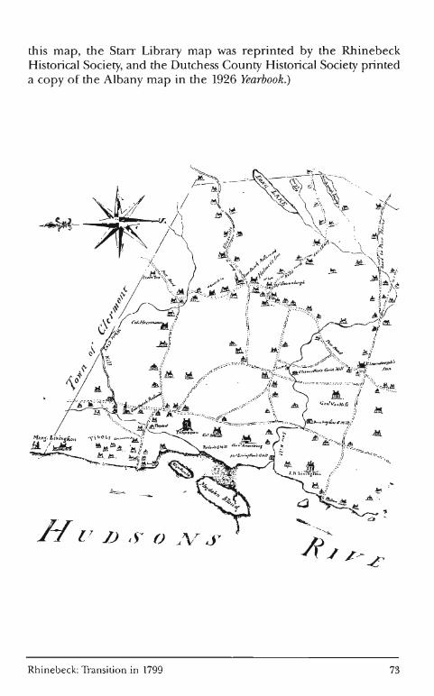
this map, the Starr Library map was reprinted by the Rhinebeck Historical Society, and the Dutchess County Historical Society printed a copy of the Albany map in the 1926 Yearbook.)
Rhinebeck: Transition in 1799 73
Each of the three maps differs in some details. The most consistent element is the Albany Post Road, since a notation on the map, "Post Road prepared from actual survey", indicates that all roads were not surveyed for mapping purposes. The maps include sketches of houses and buildings. Names of tavern owners and mills are also shown, as well as names of significant home owners or estates. Curiously in some cases roads are not drawn, but houses along the roadway are depicted. All the copies were prepared at a scale of 40 chains to an inch and carry survey notations of metes and bounds along the inland borders of the town. The Delafield copy has an additional notation in the lower right hand corner: "Feb 2, 1799." Other features shown indicate that this copy was amended to include 1799 information. The Turnpike Road, which led from Long Dock to Salisbury, Connecticut, along a portion of the old Sepasco Trail, was not officially established until 1802; however, on the Delafield copy, the right-of-way is drawn over the former roadway. The addition of Rev. Freeborn Garretson's homesite on the river and the Wurtemburg Mills also indicate the update. Each copy of the map displays some information which is not found on the other copies. We are therefore fortunate to have located these three copies and to have the benefit of their variety of information.
There is no explanation why there are three versions. The Delafield map seems to be more complete and, in addition, carries more recent information. Surveys and maps were made for several other towns in Dutchess County during 1797 and 1798 by various surveyors. These maps, filed in Albany, include Poughkeepsie, Beekman, Fishkill, and a large map of Clinton, Stanford, Washington, and Amenia. No local copies of these maps are known to exist. The survey and mapping may have resulted in part from a settlement of the boundary between Dutchess and Columbia Counties and in part from anticipation of the preparation of tax assessment rolls.
An act of the state legislature, May 23, 1799, provided for a change in the southern boundary of Columbia County,3 altering the division of the counties of Dutchess and Columbia in the area between Rhinebeck and Clermont.4 It provided that "the line be drawn due east from the south bank of Sawyer's Kill on the west side of the Hudson, continued due east until it meets with a line established by Robert R. Livingston and Zachariah Hoffman (deceased) and others as their mutual boundary, and continued along the same course to the southernmost bend of the Roeloff Jansen Kill." Zachariah Hoffman died in 1798; therefore, the boundary must have been agreed upon prior to his death. 5 The 1798 map of Rhinebeck and a 1798
74 The Hudson Valley Regional Review
map of the towns of Livingston, Germantown, and Clermont, both show the straight line extending from the river to the bend in the Roe Jan. This boundary was maintained until 1870 when the present boundary was represented.6
A study, undertaken by the Rhinebeck Historical Society in 1968 to survey extant buildings depicted on the Starr Library's copy of the Thompson map, noted a correlation between the architecture of a building and the representative drawing. For the more significant structures, similarities between the drawing and the actual building can be identified (See Illustration 1), with features such as the number of chimneys and stories depicted on the map offering an indication of actual conditions.7
T he tax assessment rolls were assigned to the New York State Library for storage and have recently been made available for research. The rolls for Rhinebeck, most of which are in a good state of preservation, are ,available for the years 1799 through 1804 and include the name of the citizen, a description of his property, the value of the real property, his personal property, and the tax to be paid. In some cases former owners are indicated in the description, while in other cases partnerships are indicated by listing the ownership of the property in several names.
In studying these sources of information, an understanding of the history of Rhinebeck during the period oflandgrants and settlement is necessary. This information may then be used to analyze the economic and social standing of the inhabitants. A continuing genealogical study of Hudson Valley families by Arthur C.M. Kelly and the author has contributed to this analysis. During the past 20 years, this work has included Mr. Kelly's publication of over 80 volumes of churches records giving such vital statistics as marriages, baptisms, and deaths. During these years research was also conducted on hundreds of area families which supplied information about the ancestral homes of many settlers and traced subsequent generations in the Hudson Valley.
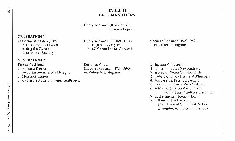
There are several themes which become apparent in the course of the analysis. First, an awareness of the Beekman heirs is important to an understanding of the social fabric, as well as the land development patterns. Since Margaret Beekman was Henry Beekman, Jr.'s only heir, the surname was lost in the next generation. The heirs of the first Henry Beekman were born to the Beekman, Livingston, and Rutsen families, and marriage of the females in these families make
Rhinebeck: Transition in 1799 75
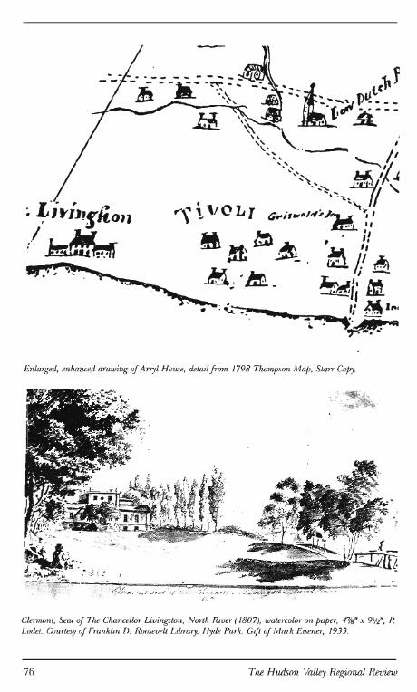
Enlarged, enhance.d drawing of Arryl House, detail from 1798 Thompson Map, Starr Copy.
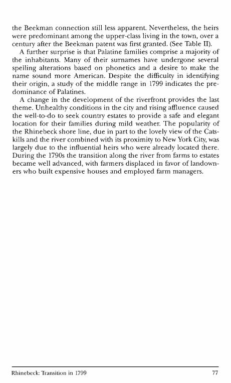
Clermont, Seat of The Chancellor Livingston, North River (1807), watercolor on paper, 47A3" x 9¥.!" , p. Lodet. Courtesy of Franklin D. Roosevelt Library, Hyde Park. Gift of Mark Eisener, 1933.
76 The Hudson Valley Regional Review
the Beekman connection still less apparent. Nevertheless, the heirs were predominant among the upper-class living in the town, over a century after the Beekman patent was first granted. (See Table II).
A further surprise is that Palatine families comprise a majority of the inhabitants. Many of their surnames have undergone several spelling alterations based on phonetics and a desire to make the name sound more American. Despite the difficulty in identifying their origin, a study of the middle range in 1799 indicates the predominance of Palatines.
A change in the development of the riverfront provides the last theme. Unhealthy conditions in the city and rising affluence caused the well-to-do to seek country estates to provide a safe and elegant location for their families during mild weather. The popularity of the Rhinebeck shore line, due in part to the lovely view of the Catskills and the river combined with its proximity to New York City, was largely due to the influential heirs who were already located there. During the 1790s the transition along the river from farms to estates became well advanced, with farmers displaced in favor of landowners who built expensive houses and employed farm managers.
Rhinebeck: Transition in 1799 77
-.J 00
;:l '"
~ §
~ !' ~ §' ~
~ ~ .
GENERATION 1 Catharine Beekman (1683-
m. (1) Cornelius Exveen m. (2)John Rutsen m. (3) Albert Pawling
GENERATION 2 Rutsen Children: 1. Johanna Rutsen 2. Jacob Rutsen m. Alida Livingston 3. Hendrick Rutsen 4. Catharine Rutsen m. Peter TenBroeck
'D\BLEII BEEKMAN HEIRS
Henry Beekman (1652-1716) m. Johanna Lopers
Henry Beekman, Jr. (1688-1776) m. (I) Janet Livingston m. (2) Gertrude Van Cortlandt
Beekman Child: Margaret Beekman (1724-1800) m. Robert R. Livingston
Cornelia Beekman (1693-1742) m. Gilbert Livingston
Livingston Children: I. James m. Judith Newcomb 3 ch. 2. Henry m. Susan Conklin II ch. 3. Robert G. m. Catherine McPheaders 4. Margaret m. Peter Stuyvesant 5. Johanna m. Pierre Van Cortlandt 6. Alida m. (l)Jacob Rutsen 2 ch.
m. (2) Henry Van Rensselaer 7 ch. 7. Catherine m. Thomas Thorn 8. Gilbert m.Joy Darrell
(5 children of Cornelia & Gilbert Livingston who died unmarried)
~ 5' n> v n> ('"l
?':
~ ::l ~. g. ::l
::l
:::J <.D <.D
-.) <.D
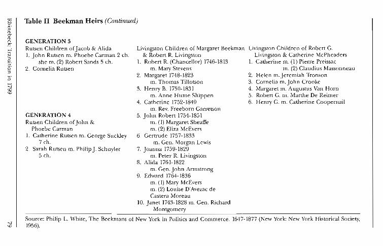
Table II Beekman Heirs (Continued)
GENERATION 3 Rutsen Children of Jacob & Alida 1. John Rutsen m. Phoebe Carman 2 ch.
she m. (2) Robert Sands 5 ch . 2. Cornelia Rutsen
GENERATION 4 Rutsen Ch ildren of John &
Phoebe Carman 1. Catherine Rutsen m. George Suckley
7 ch . 2. Sarah Rutsen m. Philip J. Schuyler
5 ch.
Livingston Children of Margaret Beekman & Robert R. Livingston
1. Robert R. (Chancellor) 1746-1813 m. Mary Stevens
2. Margaret 1748-1823 m. Thomas Tillotson
3. Henry B. 1750-1831 m. Anne Hume Shippen
4. Catherine 1752-1849 m. Rev. Freeborn Garretson
5. John Robert 1754-1851 m. (1) Margaret Sheaffe m. (2) Eliza McEvers
6. Gertrude 1757-1833 m. Gen. Morgan Lewis
7. Joanna 1759-1829 m. Peter R. Livingston
8. Alida 1761-1822 m. Gen.John Armstrong
9. Edward 1764-1836 m. (1) Mary McEvers m. (2) Louise D'Avezac de Castera Moreau
10. Janet 1743-1828 m. Gen. Richard Montgomery
Livingston Children of Robert G. Livingston & Catherine McPheaders
1. Catherine m. (1) Pierre Preissac m. (2) Claudius Massonneau
2. Helen m.Jeremiah Tronson 3. Cornelia m. J ohn Crooke 4. Margaret m. Augustus Van Horn 5. Robert G. m. Marthe De Reimer 6. Henry G. m. Catherine Coopernail
Source: Philip L. White, The Beekmans of New York in Politics and Commerce. 1647-1877 (New York: New York Historical Society, 1956).
History
Rhinebeck was established in 1686 when a treaty, purchasing land in an area centering on the present hamlet of Rhinecliff, was obtained from the Indians. A patent issued in 1688 confirmed the title to this land. The patentees were Gerret Aertsen (Van Wagenen), Arie Roosa, and Jan Elton. Land to the north of the Roosa parcel was purchased by brothers Hendrick and Jacob Kip and was included in the patent. All patentees were residents of Ulster County. Kingston, a prominent early Dutch settlement, was located directly across the river from the patent, offering convenient church and civi l amenities.
F or an estate, the desirability of river front property offering a view of the Catskills was soon established, and a process began which was to result in conversion of all of the river front farms to estates, leaving the middle-class farmer to content himself with dwelling on the fertile fields to the interior. An early example of this transition was the exchange of land effected between Henry Beekman and Valentine Benner in 172J.I3 The Benner farm was located on property which .is now the site of the Rokeby estate. Beekman offered land in fee simple for the river front leasehold of Benner, and the Benners obliged by selecting land about a mile and one half southwest of Red Hook village. A later notable exchange ofland occurred between Freeborn Garretson and Johannes Van Wagenen. Freeborn Garretson's wife, Catherine, was a granddaughter of Henry Beekman, Jr., and since many of her siblings lived along the river, she also desired property nearby.14 The original Garretson homesite was in the area known as Schooterhoek, near Bollenecker Road, where Rev. Garretson had established a Methodist Church on the Sepasco Trail. Despite the location of the church, a decision was made to move to the river and, in 1799 the Garretsons built Wildercliff, which still commands an imposing view down the river. Thus they joined the ranks of the elite along the river. The church was relocated three miles west in the village.
The process of acquisition of river front land for estate properties continued throughout the 19th century until the river front hamlets, which were built around the 1799 landings, became the only areas on the river where the land was not part of the estates. The last decade of the 18th century saw this pattern developing in earnest.
80 The Hudson Valley Regional Review
T he assessment rolls reveal a wide range of economic means within the town. John R. Livingston, a grandson of Henry Beekman and the most wealthy property owner, possessed real estate valued at $19,460 and personal property of $2,241. His situation may be contrasted with those whose personal property was valued at $10-19 and who were taxed at only one penny. Fourteen men are listed in that category, with renters and craftsmen possibly in this group.
There were over 100 persons in the town with no taxable real property and a personal estate of under $100. Some were young men of established families who were in the process of acquiring their own property. Another group were persons whose names do not appear in later records of the town. It is apparent that these people moved on to other places before settling and acquiring land. In the lowest tax bracket, there were many listed who paid less than ten cents tax. Palatine and Dutch names are common among these. However,Jacob Burchell, John Burd, Augustus Gauty, John Logan, John McMurray, James McMurray, David L. Perkins, Henry Watt,Jun., Simon Babcock, Andrew Blake, Isaac Cain, Adam Marshall, William Currie, Cornbery Dayton, John Ellison, George Nond, Stephen Westcoat, Dena Cruys, and Samuel Fink are all examples of persons who do not appear in the 1810 census of Rhinebeck, so we may assume that they either died or did not become established here.
The only man listed as a negro was Francis Roe whose name may have been taken from the Rowe, Rau, Rauh family of Northeast in Dutchess County. It was common practice for slaves to acquire the surname of a family with which they had been closely associated. Francis Roe's personal estate amounted to $20. There were other blacks living in the town, but they probably were not free men and so were not assessed.
The majority of the citizens belong to the occupational classes of farmers and merchants. Much of the real estate is described as "house and farm" and the value ranges from a few hundred dollars to sev-eral thousand. '
The Dutch descendants of the original patentees, Kip, Van Wagenen, Ostrom, Van Etten, Heermance, Pells, and others fall into the middle range of the list. During the century which had elapsed since the patents were granted, their assets had been divided among many descendants. Female heirs were given equal treatment with male heirs, and since the original acreage was much smaller than the Beekman patent, the result was that there was less wealth among this group. In the northern portion of the town, descendants of the purchasers of
Rhinebeck: Transition in 1799 81
the Schuyler patent shares, the Hoffman and Van Benthuysen families had been prominent land owners in the early 18th century. By 1799 much of their holdings had been sold. John Van Benthuysen (#522), who later sold the land that became Montgomery Place to Janet Montgomery, had a house, farm and mill worth $5,010 and personal property of $923 in 1799.15 Nicholas Hoffman (#403), had $4,860 in real and $890 in personal assets.
There were 89 individuals who paid taxes of between $2 and $4. No Livingston or Beekman family members are evident in this group. Palatine surnames deriving from the 1710 emigration comprise 52 percent of this grou p. The Dutch, a total of 22 persons, make up an additional 26 percent. The remainder are composed of later Palatine arrivals, English, and undetermined origins. The Palatine family descendants were particularly prolific, and although descendants in each generation probably left their parents to seek better prospects, many persisted in Rhinebeck so that a majority of the names on the tax list can be traced to the 1710 emigration. In 1799 the houses of Palatine descendants were mainly one- or one and a halfstory stone or frame structures. The Feller (Fellor) and the Mohr houses on River Road, north of the bridge approach, are examples of the substantial but practical dwellings most occupied. They were engaged in farming and were quite self-sufficient.
The Wurtemburg families, as already described, settled about 1730. It is interesting to note that by 1799 members of these families were all in the middle wealth category ($1 to $2 tax). The families included the names Asher, Progue, Pultz, Wager, Cookingham (Kookingham), Marquart, and Brown. Simple one and one-half story frame houses on Wurtemburg road, such as the Pultz house c. 1760 north of the church, and sturdy stone houses on the roads to the west, such as the Progue house (1763) on Primrose Hill Road and the Asher house (1762) on Ackert Hook Road, may be easily found to illustrate their lifestyle.
In this middle range, there are few family names not carried on in 19th century Rhinebeck. Even an unusual name such as KuitJaquis (Wait Jaques) may be found listed on the 1810 census as living in Rhinebeck with a sizable family. A study of Rhinebeck history shows the family involved in such commercial activities as Captain of a sloop and owner of the Beekman Arms. Henry Lyle, whose name is not on the 1810 census, may have died by that time; he was a Town Clerk and prominent tavern keeper in Upper Red Hook. William Wallis is a single example of a name from this category whose name is unfamiliar and who does not appear on the 1810 census.
82 The Hudson Valley Regional Review
Forty-seven persons were taxed in amounts over $4; thus their real and personal property was valued at over $4,000. Among this elite group, nine Livingston children and in-laws may be identified, along with six 17lO Palatine families, two later Palatine families, and ten early Dutch families. The salient point, however, is that while most of the others had assets confined to one township, the Livingstons and newcomers in this group probably had their assets in several civil divisions.
Of the 19 persons with real property values over $5,000, only one is of Palatine descent. John N. Traver ranks ninth with a value of $7,0 lO for his house and farm. There are four Livingston men among this group: John R. Livingston, Henry G. Livingston, Henry R. Livingston, and Philip H. Livingston. Robert Sands, Philip Schuyler, Thomas Tillotson, and John Armstrong, who are also listed, each married Beekman heirs.
John Armstrong, a Pennsylvania native who married Alida Livingston, daughter of Robert Livingston and Margaret Beekman, purchased 200 acres from Garret Van Benthuysen in 1795 which included the tract of land on which Blithewood was built, now part of Bard College. In 1790 his wife's mother gave Mrs. Armstrong two mills on the Saw Kill which had been purchased in 1760 from the Van Benthuysen family.16
Henry G. Livingston, (#8) a Beekman grandson, bought land from the Hoffman family in 1794. The house called Green Hill (The Pynes) was probably built at about that time. An indication of property values may be obtained through the description written in an advertisement for sale of the property. The first, from the Poughkeepsie Journal, dated January 30, 1798, describes the house in detail:
The house which consists of two stories, is large and convenient, having a wing on each side connected by a piazza eighty feet long; one of the wings is a well finished breakfast room, the other is a kitchen; the house has lately been thoroughly repaired; the smoke-house, granary, overseer's house, wash-house and barn are in the best order ... there is a well of good water, two cisterns, and excellent kitchen and fruit garden, enclosed by a high pale fence ... also about 200 fruit trees of various kinds which were set out two years ago.
A second advertisement, from the American Farmer and Dutchess County Advertiser, September 3, 1797, indicates other assets, stating the farm "consists of four-hundred acres of land; three houses, three barns, ... the stock, which at present consists of 50 cows and heifers and an
Rhinebeck: Transition in 1799 83
English Bull; about 30 head of other cattle; horses, mares, colts, carts, waggons, harrows, ploughs and 100 tons of hay will be sold reasonable and on a credit."17
In total assets, Henry G. Livingston ranked sixth in the town with a house and farm valued at $10,435 and personal assets at $2,693. In addition to "The Pynes" where Henry was living in 1799, he also built the Pamdon House and the Callendar House. Callendar House was purchased by Philip H. Livingston, a grandson of Philip Livingston, the signer of the Declaration of Independence. Philip had lived in Jamaica for some years but purchased the house and 44 acres on October 13, 1795.18 This assessment roll only allows comparison of his assets in Rhinebeck with others in the town, but he undoubtedly had property in many locations. However, this house and acreage was the subject of Philip's assessment of $6, 186 in real property and $640 in personal property in Rhinebeck.
Philip J. Schuyler was a member of a prominent Albany family, son of the Revolutionary War General Philip Schuyler. He married "Sally" Rutsen, the daughter of Col. John Rutsen and a fourth generation Beekman heir. His house in Rhinebeck known as "The Grove" was built in 1792 and 1793. Their children include Philip P., John Rutsen, Catharine M. who married Samuel Jones, Siby who died young, Robert, and Stephen who married Catharine Morris.19 Robert Sands was the second husband of a great granddaughter of Henry Beekman. His house, built south of the Landmanskill, was associated with that of the Schuylers. The Sands and Schuyler properties were the main inland focus of the upper-class. Their connection with the Beekman, Schuyler, and Livingston families ensured their continuing prominence. Schuyler's house and Sand's house both stand today on Miller Road in Rhinebeck. They are protected by facade easements and have recently undergone rehabilitation.
A closer study of more recent wealthy landowners such as Mr. DeLabigarre of Tivoli, reveals that he is also connected to the Livingston and Beekman families. The Year Book of the Dutchess County Historical Society, 1929, contains an article entitled, "Peter DeLabigarre, and the founding of Tivoli," written by Helen Wilkison Reynolds. She explains that the sudden arrival of a number of French families in Rhinebeck was caused by increased trade relations between America and the West Indies and increased emigration from France to America due to the French Revolution. Five Frenchmen who settled in what is now the Town of Red Hook, which in 1799 was part of Rhinebeck, are identified: Pierre Joseph Preissac, Claudius G. Massonneau, Peter DeLabigarre, Cladius Gabriel Fontaine, and
84 The Hudson Valley Regional Review
Daniel Brizac or Prizock. Mr. Preissac married Catharine Livingston, daughter of Robert G. Livingston and Margaret Hyde Livingston and settled near Rock City. After he died in 1794 or 1795, his widow married Claudius G. Massonneau.
Peter DeLabigarre first gave a mortgage to Robert R. Livingston in 1793 for property in Red Hook.20 His activity in property sales in the vicinity of Tivoli is shown in Deed Books from 1793 to 1802. The New York Reformed Church marriage record shows that he married Margaret Beekman June 16, 1795.21 She was the daughter of Gerard William Beekman, a cousin of Henry Beekman (of Beekman Genealogy). Another daughter married Isaac Cox, and a third daughter, Eliza, married Peter William Livingston. The brother-in-Iaws, Peter De Labigarre and Peter W. Livingston, were involved in many land transactions. The land acquired by Mr. DeLabigarre included two tracts adjoining the estates presently known as The Pines and Callendar House. One of the parcels included the area of the Village of Tivoli. He laid out a plan for a village and had a map of the proposed development prepared. A print of this plan for Tivoli is on file with the Dutchess County Clerk. While the enterprise eventually failed, Mr. DeLabigarre did build a home in the area about 1798. He died about 1807. His house was owned in later years by Johnston L. DePeyster.
Daniel Prizock, who is listed in the 1790 federal census, had a home near the Village of Tivoli which is shown on the 1798 map. Since the name is phonetically similar, it is possible that he was related to Pierre Preissac.
The fifth Frenchman described is Cladius Gabriel Fontaine, who did not purchase lots in Tivoli until 1802 but whose property remained in the family until 1864.22
Despite the fact that most members of this group were located on the river, one isolated site existed in Rock City near Oriole Mills. The mill is Crook's Grist mill in 1799, but there were also a saw mill and a fulling mill in the area. The land was passed on in the Beekman family and, in addition to the mill sites, there was also the residence of Pierre Preissac and Catherine Livingston, who later married Claudus Massonneau and then moved to a river location. Samuel Hake also resided there. His marriage to Helen Livingston may be found recorded January 9,1769, in the New York Reformed Church marriage record.23
David Van Ness probably came to this area when he married a daughter of Andries G. Heermance. He first lived in Upper Red Hook, east of the Post Road to the north of the brick tavern.24 He was a
Rhinebeck: Transition in 1799 85
member of the State Assembly in 1790 and later built a house in the present Village of Red Hook where he lived until about 1815. He was the first Supervisor of Red Hook when it separated from Rhinebeck.
Parndon was purchased by Jaspar Parsons, a "newcomer." Henry Livingston had built the house on a solid rock, looking out toward the river. Upon completion, it was advertised for sale and purchased by Mr. Parsons, a British subject from St. Croix. The house was demolished about 1909 by Gordon Hamersley. The property became a part of Ward Manor, presently the northern edge of Bard College.25
Jaspar Parson's personal property must have included the thoroughbred horses he was raising. The Poughkeepsie Journal in 1799 referred to one stallion called "Escape" which was an especially valuable animal. Parsons was also a large slave holder. His personal property was valued at $3,304, the most for anyone on the assessment roll.
Most of the landowners in this group are descendants of the large landholders such as the Livingstons and the Beekmans; thus more than a century after the original patents were issued, the descendants still appear to own sizable property in 1799
Slavery
Slavery was found in Rhinebeck throughout the first century of development. Evidence may be found in the settlement of estates and in the census records as well as in newspaper advertisements for runaways. In 1801 legislation was passed which would free many slaves of age, who could provide for themselves. However, in the 1790 census, there were 491 listed for the town. A bill of sale dated April 19, 1785, lists the sale of a 17-year-old black man, Peete for £80 and a black "wench", Nancy, 54 years old for £30 to Benjamin Van Steenburgh.26 Slaves were considered assets and so would have been included in the assessment rolls as personal property to be taxed.
In 1790 Henry G. Livingston owned 13 slaves. Andries Heermance, Robert Sands, Volkert Whitbeck, and Henry B. Livingston each owned 11; Zachariah Hoffman owned ten; Moses Cantine and David Van Ness each had nine; Morgan Lewis,John Stickle, and Jeremiah Van Auken each had eight; and Everardus Bogardus and Johannes Kiersted owned seven each. There were others with fewer slaves.
By 1800 Andrew Heermance had twelve slaves, Andrew DeVeaux had ten, Frederick 1. Sipperly and Henry Benner each had nine, Nicholas Hoffman and Volkert Whitbeck each had eight slaves, while
86 The Hudson Valley Regional Review
Zachariah Hoffman, John Klum, Jacob Van Benthuysen, Cornelius Elmendorph, William Radclift, Jr., John Stickle, David Van Ness, Henry Shop, Martin Heermance, Henry B. Livingston, Adriana Borgardus, and Robert Sands each had six. Many other residents had slaves but in smaller numbers. All would have been included in the personal property listed in the assessment rolls.
Citizens of Rhinebeck who represented the area in the State Senate during this period were Thomas Tillotson (1791-1799), Robert Sands (1797-1800), and Peter Can tine (1798). Tillotson's assessment was $6,350 real and $4,300 personal. Sand's assessment was placed at $5,760 real and $899 for his house and farm (#3) and also part of the assessment (#273) for the dock listed with John Schultz at $400. Peter Cantine (Jr.) (#16) is shown with $3,350 for house and lot and $1,526 personal. Philip]. Schuyler represented Rhinebeck in the Assembly in 1798. His assets are valued at $7,500 for house and farm and $6,234 for personal. ,Town Supervisor Isaac Stoutenberg (#31) is shown with a house and farm valued at $3,150 and $516 personal assets, Henry Shop (#28), Town Clerk in 1799, appears with $3,270 for house and farm and $2,144 for personal assets,
The Town meeting in 1799 was held the first Tuesday in April at the house of Frederick Tator, In addition to the election of Isaac Stoutenburgh,Jr, as Supervisor, and Henry Shop as Town Clerk, the Assessors elected were Martin Vosburgh, George Ring, Peter Feller, Martin Heermance, and Andrew G. Heermance. These men had assets eliciting taxes ranging from $2,15 to $7.58. The tax collector elected was Jacob Schultz, John Stickle and Martin Heermance were elected overseers of the Poor. William Radclift, George Feller, and David Van Ness were appointed Commissioners of the Highways; George Hagadorn, Lewis Fraligh and Jacob Signer were elected Constables; and Abraham]. Kip, Gotlop Martin, Jacob Moul, Peter Feller, and Aaron Camp were elected fence viewers. Jacob Moul and John A. Kip were elected Pound Masters, and Commissioners of Schools were Anthony D. Lemater, Isaac Davis, and Henry D, Witt, Junior. Most of these town officials were descendants of Palatine families, as shown above by the names in bold face type, with the remainder Dutch, with the exception of Isaac Davis. While the DeLamaeter name is of French origin, the family is considered of the Dutch period, George Ring's name appears English, but marriage records of the Athens Lutheran Church prove the family came
_from Germany.27 Palatine names were often Anglicized.
Rhinebeck: Transition in 1799 87
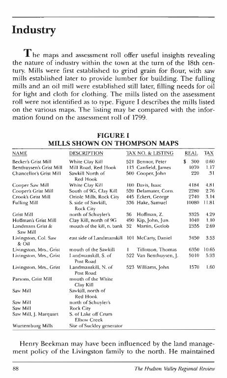
Industry
T he maps and assessment roll offer useful insights revealing the nature of industry within the town at the turn of the 18th century. Mills were first established to grind grain for flour, with saw mills established later to provide lumber for bu ilding. The fu lling mills and an oil mill were established still later, fill ing needs for oil for light and cloth for clothing. The mills listed on the assessment roll were not identified as to type. Figure I describes the mills listed on the various maps. The listing may be compared with the information found on the assessment roll of 1799.
FIGURE I MILLS SHOWN ON THOMPSON MAPS
NAME DESCRIPTION lAX NO. & LISTING REAL lAX
Becker's Grist Mi ll Wh ite Clay Kill 52 1 Bennor, Peter $ 300 0.60 Benthuysen's Grist Mill Mil l Road, Red Hook 113 Canfield, j ames 1070 1.17 Chancellor's Grist Mill Saw ki ll North of 500 Cooper,john 220 .3 1
Red Hook Cooper Saw Mill Wh ite Clay Kill 100 Davis, Isaac 4 184 4.8 1 Cooper's Grist Mi ll South of9G, Clay Kill 520 Delamater, Corn. 2280 2.76 Crook's Grist Mill Oriole Mills, Rock City 445 Eckert, George 2740 3.14 Fulling Mill S. side of Sawkill, 336 Hake, Samuel 10080 11.81
Rock City Grist Mill north of Sch uyler's 36 Hoffman, Z. 3325 4.29 Hoffman's Grist Mill Clay Kill, north of9G 490 Kip,john, jun. 1040 1.10 Landmans Grist & mouth of the kill, n. bank 32 Martin, GOllob 2355 2.69
Saw Mill Livingston, Co l. Saw east side of Landmanski ll 101 McCarty, Danie l 3450 3.53
&Oil Livingston, Mrs ., Grist mouth of the Sawkill Ti llotson, Thomas 6350 10.65 Livingston, Mrs. , Grist Landmanskill , S. of 522 Van Benthuyse n, j. 5010 5.93
Post Road Livingston, Mrs ., Grist Landmanskill, N. of 523 Williams,john 1570 1.60
Post Road Parsons, Grist Mi ll mouth o f the While
Clay Kill SawMill Saw kill , north of
Red Hook Saw Mill north of Schuyler'S Saw Mill Rock City Saw Mill,j. Marquart S. of Lake off Crum
Elbow Creek Wurlemburg Mills Site of Suckley generator
Henry Beekman may have been influenced by the land management policy of the Livingston fami ly to the north. He maintained
88 The Hudson Valley Regional Review
control of many mill sites and preferred to sell his land by leasehold rather than transfer title in fee simple. Soon after his patent was confirmed, Henry purchased the rights to a mill at the mouth of the Landmanskill. The Beekman-Livingston mills near the spot where the Landmanskill is crossed by the Post Road were erected in 1715.28
This excellent mill site probably had a great influence on the eventual development of Rhinebeck Flatts. On the 1798 map, five mills are attributed to Beekman descendants, and seven mills have no surname connected with them. These may have been operating under a lease with their heirs. Hoffman and Benthuysen mills were operated by other early land holding families. Parsons was a new landowner, having purchased his property in 1795.29 The Wurtemburg Mills, shown on the Delafield map, were erected in 1800 by Gov. Morgan Lewis. 30
In the 18th century, the river offered the most important means of transportation for commerce. In 1798 there were four docks located at convenient intervals along the town's shoreline. The Schultz dock, primarily for the Palatine settlement at Kirchehoek Corner, was located to the south of the present Kingston-Rhinecliff Bridge. A road led from Wurtemburg, through Schuyler'S past the mills, through the German settlement near Stone Church to the river.
Can tine's dock, near present-day Tivoli, served the area then known as Red Hook (now Upper Red Hook), Livingston's Landing in the present Barrytown area served the lower Red Hook area, and Radcliff's Landing was at Long Dock near the area now known as Rhinecliff. Not shown on either the maps or assessment rolls are Beekman's former dock at the mouth of the Landmanskill, which had served the southern part of Rhinebeck and was later supplanted about 1802 by the Lewis dock a bit further north.
Few mills have survived. There is a mill building near Schuylers which has been converted into a dwelling and is now owned by Henry Staley. An undated mill building stands in Rock City on the Saw kill, near the Milan line. Fire seems to have been a common means of destruction of the mills and it is unfortunate that most succumbed.
Many ofthe docks have also disappeared. Those at Barrytown and Tivoli are the only ones shown on the map which are still used today.
Figure II lists the docks as shown on the 1798 maps.
Rhine beck: Transition in 1799 89
90 The Hudson Valley Regional Review
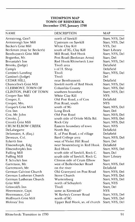
THOMPSON MAP TOWN OF RHINEBECK
December 1797, January 1798
NAME DESCRIPTION
Armstrong, Gen'l north of Saw ki II Armstrong's Saw Mill Upstream on Sawkill Becker's Grist Mill White Clay Kill Beekman (may be Becker's) south of 9G, Clay Kill Benthuysen's Grist Mill Mill Road, Red Hook Bogardus, Mr. Post Road (Beekman Arms) Bonastale's Inn Red Hook/Rhinebeck Line Brooks, Gudge) Tivoli area Camp's s ofH. Shop Cantine's Landing Tivoli Cantine's Gudge) Tivoli CEDAR HILL near Benthuysen's Chancellor's Grist Mill Saw kill north of Red Hook CLERMONT, TOWN OF Columbia County CLINTON, PART OF TOWN southern boundary Cooper Saw Mill White Clay Kill Cooper, E. Old Post Road, s of Cox Cooper, Mrs. Post Road, south Cooper's Grist Mill south of9G Cox Inn Long Dock Cox, Mr. John Old Post Road Crooke,]. south side of Oriole Mills Rd. Crook's Grist Mill Rock City CRUM ELBOW CREEK Eastern boundary of town DeLabegarre North Bay Delamater, A. (Esq.) E. of Post Road, s of village Deveaux, Col. Bard College area Eckert's Inn west of Violet Hill Road Elmendorph, Edg. near Stoutenburg in Red Hook Elmendorph's Inn Red Hook Fulling Mill south side of Sawkill, Rock C. Fulling Mill south side of Saw kill, Rock C. F. Schultz's Inn Clinton side of Crum Elbow Garretson, Mr. west of Bollenbecker Road Garrettson's, Mr. on the river German Calvinst Church Old Graveyard on Post Road German Lutheran Church Stone Church German Lutheran Church Wurtemburg Grist Mill north of Schuyler's Griswold's Inn Tivoli H eermance, Capt. same as Kierstead? H eermance, Col W. Kerley's Corner Road Hoffman's Grist Mill north of9G Holmes'Inn Upper Red Hook, so. of church
Rhinebeck: Transition in 1799
MAP
Starr, NYS, Del Starr, NYS, Del NYS, Del Starr Library Starr, NYS, Del Starr, Del Starr, NYS, Del Delafield Delafield Starr, NYS, Del Del Delafield Starr, NYS, Del Starr, NYS, Del Starr, NYS, Del NYS Delafield NYS Starr, NYS, Del Starr, Del Starr, NYS, Del Starr, NYS, Del Starr, NYS, Del Starr, NYS Delafield Delafield Starr, NYS, Del Starr, Del Delafield Starr, NYS, Del Starr, Del Starr Library Starr Starr, NYS, Del Delafield Starr, NYS, Del Starr, NYS, Del Starr, NYS, Del Starr, NYS Starr, Del NYS Starr, NYS, Del Starr, NYS, Del Starr, NYS, Del
91
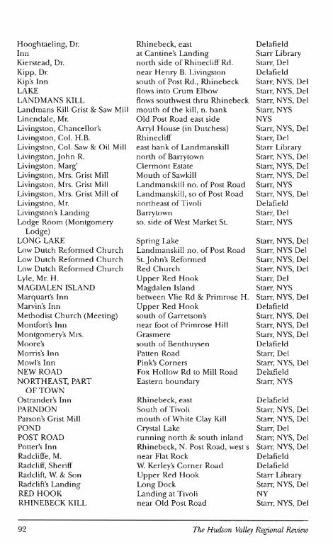
Hooghtaeling, Dr. Rhinebeck, east Delafield Inn at Cantine's Landing Starr Library Kierstead, Dr. north side of Rhinecliff Rd. Starr, Del Kipp, Dr. near Henry B. Livingston Delafield Kip's Inn south of Post Rd., Rhinebeck Starr, NYS, Del LAKE flows into Crum Elbow Starr, NYS, Del LAND MANS KILL flows southwest thru Rhinebeck Starr, NYS, Del Landmans Kill Grist & Saw Mill mouth of the ki ll, n. bank Starr, NYS Linendale, Mr. Old Post Road east side NYS Livingston, Chancellor's Arryl House (in Dutchess) Starr, NYS, Del Livingston, Col. H.B. Rhinecliff Starr, Del Livingston, Col. Saw & Oil Mill east bank of Landmanskill Starr Library Livingston,John R. north of Barrytown Starr, NYS, Del Livingston, Marg' Clermont Estate Starr, NYS, Del Livingston, Mrs. Grist Mill Mouth of Sawkill Starr, NYS, Del Livingston, Mrs. Grist Mill Landmanskill no. of Post Road Starr, NYS Livingston, Mrs. Grist Mill of Landmanski ll , so of Post Road Starr, NYS, Del Livingston , Mr. northeast of Tivoli Delafield Livingston's Landing Barrytown Starr, Del Lodge Room (Montgomery so. side of West Market St. Starr, NYS
Lodge) LONG LAKE Spring Lake Starr, NYS, Del Low Dutch Reformed Church Landmanskill no. of Post Road Starr, NYS Del Low Dutch Reformed Church St.john'S Reformed Starr, NYS, Del Low Dutch Reformed Church Red Church Starr, NYS, Del Lyle, Mr. H. Upper Red Hook Starr, Del MAGDALEN ISLAND Magdalen Island Starr, NYS Marquart's Inn between Vlie Rd & Primrose H. Starr, NYS, Del Marvin's Inn Upper Red Hook Delafield Methodist Church (Meeting) south of Garretson's Starr, NYS, Del Montfort's Inn near foot of Primrose Hill Starr, NYS, Del Montgomery's Mrs. Grasmere Starr, NYS, Del Moore's south of Benthuysen Delafield Morris's Inn Patten Road Starr, Del Mowl's Inn Pink's Corners Starr, NYS, Del NEW ROAD Fox Hollow Rd to Mill Road Delafield NORTHEAST, PART Eastern boundary Starr, NYS
OFTOWN Ostrander's Inn Rhinebeck, east Delafield PARNDON Squth of Tivoli Starr, NYS, Del Parson's Grist Mill mouth of White Clay Kill Starr, NYS, Del POND Crystal Lake Starr, Del POST ROAD running north & south inland Starr, NYS, Del Potter's Inn Rhinebeck, N. Post Road, west s Starr, NYS, Del Radcliffe, M. near Flat Rock Delafield Radcliff, Sheriff W. Kerley's Corner Road Delafield Radclift, W. & Son Upper Red Hook Starr Library Radclift's Landing Long Dock Starr, NYS, Del RED HOOK Landing at Tivoli NY RHINEBECK KILL near O ld Post Road Starr, NYS, Del
92 The Hudson Valley Regional Review
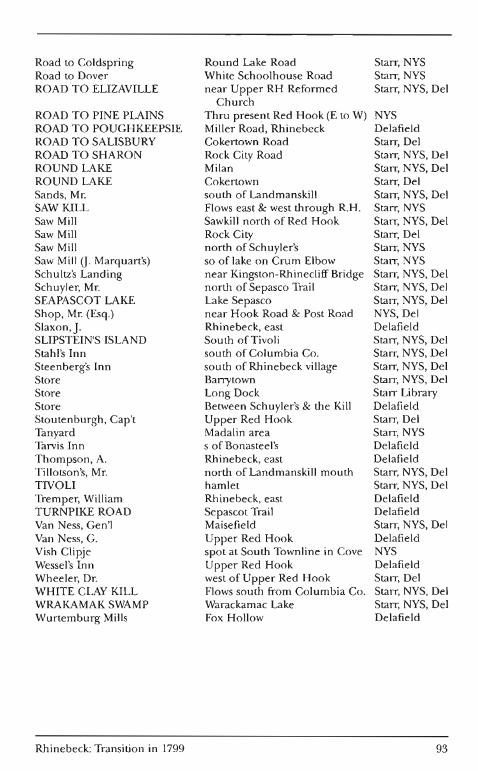
Road to Coldspring Round Lake Road Starr, NYS Road to Dover White Schoolhouse Road Starr, NYS ROAD TO ELIZAVILLE near Upper RH Reformed Starr, NYS, Del
Church ROAD TO PINE PLAINS Thru presert Red Hook (E to W) NYS ROAD TO POUGHKEEPSIE Miller Road, Rhinebeck Delafield ROAD TO SALISBURY Cokertown Road Starr, Del ROAD TO SHARON Rock City Road Starr, NYS, Del ROUND LAKE Milan Starr, NYS, Del ROUND LAKE Cokertown Starr, Del Sands, Mr. south of Landmanskill Starr, NYS, Del SAW KILL Flows east & west through R.H. Starr, NYS Saw Mill Sawkill north of Red Hook Starr, NYS, Del Saw Mill Rock City Starr, Del Saw Mill north of Schuyler's Starr, NYS Saw Mill O. Marquart's) so of lake on Crum Elbow Starr, NYS Schultz's Landing near Kingston-Rhinecliff Bridge Starr, NYS, Del Schuyler, Mr. north of Sepasco Trail Starr, NYS, Del SEAPASCOT LAKE Lake Sepasco Starr, NYS, Del Shop, Mr. (Esq.) near Hook Road & Post Road NYS, Del Slaxon,j. Rhinebeck, east Delafield SLIPSTEIN'S ISLAND South of Tivoli Starr, NYS, Del Stahl's Inn south of Columbia Co. Starr, NYS, Del Steen berg's Inn south of Rhinebeck village Starr, NYS, Del Store Barrytown Starr, NYS, Del Store Long Dock Starr Library Store Between Schuyler's & the Kill Delafield Stoutenburgh, Cap't Upper Red Hook Starr, Del Tanyard Madalin area Starr, NYS Tarvis Inn s of Bonasteel's Delafield Thompson, A. Rhinebeck, east Delafield Tillotson's, Mr. north of Landmanskill mouth Starr, NYS, Del TIVOLI hamlet Starr, NYS, Del Tremper, William Rhinebeck, east Delafield TURNPIKE ROAD Sepascot Trail Delafield Van Ness, Gen'l Maisefield Starr, NYS, Del Van Ness, G. Upper Red Hook Delafield Vish Clipje spot at South Townline in Cove NYS Wessel's Inn Upper Red Hook Delafield Wheeler, Dr. west of Upper Red Hook Starr, Del WHITE CLAY KILL Flows south from Columbia Co. Starr, NYS, Del WRAKAMAK SWAMP Warackamac Lake Starr, NYS, Del Wurtemburg Mills Fox Hollow Delafield
Rhinebeck: Transition in 1799 93
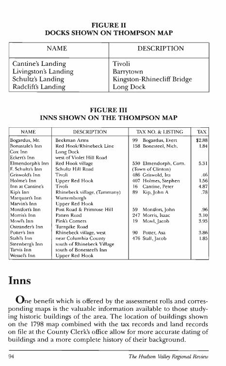
FIGURE II DOCKS SHOWN ON THOMPSON MAP
NAME DESCRIPTION
Cantine's Landing T ivoli Livingston's Landing Barrytown Schultz's Landing Kingston-Rhinecliff Bridge Radclift's Landing Long Dock
FIGURE III INNS SHOWN ON THE THOMPSON MAP
NAME DESCRIPTIO N lAX NO. & LIST ING lAX
Bogardus, Mr. Beekman Arms 99 Bogardus, Evert $2.88 Bonastale's Inn Red Hook/Rh inebeck Line 158 Bonestee l, Nich . 1.84 Cox Inn Long Dock Eckert's Inn west of Vio le t Hill Road Elmendorph's Inn Red Hook village 530 Elmendorph , Corn . 5.31 F. Schultz's Inn Schul tz Hill Road (Town of Clinton) Griswold's Inn T ivoli 486 Griswold , Ira .46 Holme's Inn Upper Red Hook 407 Holmes, Stephen 1.56 Inn at Cantine's Tivoli 16 Cantine, Peter 4.87 Kip's Inn Rhinebeck village, (Tammany) 89 Kip, J ohn A .78 Marquart's Inn Wurtemburgh Marvin's Inn Upper Red Hook Montfo rt's Inn Post Road & Primrose Hi ll 59 Montfort,John .96 Morris's Inn Patten Road 247 Morris, Isaac 3.1 0 Mowl's Inn Pink's Corners 19 Mowl,J acob 3.93 Ostr,mder's Inn Turnpike Road Po tte r's In n Rh inebeck village, west 90 Po tter, Asa 3.86 Stahl's Inn near Columbia Coun ty 476 Stall , J acob 1.85 Steenberg's Inn south o f Rhinebeck Village Tarvis Inn sou th of Bonesteel's Inn Wesse l's Inn Upper Red Hook
Inns
O ne benefit which is offered by the assessment rolls and corresponding maps is the valuable information available to those studying h istoric bu ild ings of the area. T he location of buildings shown on the 1798 map combined with the tax records and land records on fi le at the County Clerk's office allow for more accurate dating of build ings and a more complete history of their backgrou nd.
94 The Hudson Valley Regional Review
Many of the buildings which are noted on the map as inns are still in existence. The innkeepers are not noted as such on the tax records. Those who can be identified vary in wealth. Figure 3 shows the inns which were noted on the maps. Where the innkeepers could be identified, their names are included in a separate column. The . Steen burgh Inn, south of the village of Rhinebeck, Mowl's Inn near the 9 & 9G intersection, Bogardus' Inn (the Beekman Arms), and the Elmendorph Inn in Red Hook are among those buildings still standing and are now listed on the National Register of Historic Places. In Upper Red Hook, a brick tavern stood on the southeast corner of the junction of the Post Road and the road to Salisbury.31 This building has also been nominated for the National Register.
The number of inns available indicates the presence of a good deal of travel by land. This probably included stage and horseback transportation. Drovers may also have taken advantage of the inns on their way to the landings. The inn also served as the local area tavern and was a gathering place for the exchange of news, social pleasantries, and m¢st important, alcoholic beverage.
Churches
An important factor in the development of the area was the establishment of churches. The earliest church building was established by the Palatine community about 1714 and was used for both Reformed and Lutheran services. A school was also established in connection with the church;32 the minister provided instruction in the three R's in addition to his pastoral duties. The existence of the church and the availability of services conducted in the German language certainly influenced the settlement of additional German families once the first Palatine settlement was established.
By 1730 there was a church building for both the Reformed and Lutheran German congregations, and, at about that same time, a building for the Dutch Reformed congregation in Rhinebeck Flatts was erected. None of those early structures survives.
The Wurtemburg Lutheran Church answered the need of the Wurtemburg settlers who found the German church on the Post Road too far distant from their area in the southeast portion of the town. The church, first built in its present location in 1760, was rebuilt in 1802.
In 1766 a Dutch Reformed church was built in an area of Red Hook which never did become a community center. The Red Church
Rhinebeck: Transition in 1799 95
on State Route 9G still stands today, abandoned by its congregation who, centered in Upper Red Hook, constructed another building there. Architectural historians question if the present structure dates to 1766, but since no evidence has been discovered in the church records to indicate another building, it may have been changed through remodeling.33
The Stone Church, built in 1786 on the site of the first Lutheran church, may be the only church building appearing on the 1798 map which is still standing, although it is possible that parts of the Red Church structure date from the earlier period. Another church depicted on the map is the Methodist church which was later moved to the present Rhinebeck village.
The State copy of the map is careful to denote the difference between the High and Low Dutch Churches. The Rhinebeck Reformed, the Upper Red Hook Church, and the Red Church near Tivoli are marked "Low Dutch," while the German Reformed, the Stone Church Lutheran, and the Wurtemburg Lutheran are "High Dutch." The Rhinebeck Reformed, Upper Red Hook Reformed, and the German Reformed at Kirchehook are all marked with the abbreviation "Calv" for Calvinist. The Methodist location is called "Methodist Meeting" on the state map. Certainly by the end of the its first century of existence, the town was rich in ecclestical history!
Houses
S ome discussion of the estates has already been included under the analysis of large land holders. The only estate shown with a name other than the landowner is Parndon. Unfortunately this building is no longer standing. However, many of the substantial structures built during the last decade of the century have survived to lend their rich heritage to the town. The first of the large brick houses was Grasmere built during the Revolutionary War. Those of this genre from the 1790s include Callendar House, The Pynes, Maisefield, and the Grove (Schuyler's). These are supplemented by frame houses of similar proportion such as the Robert Sands House and Wildercliff. Arryl House, the home of Chancellor Robert R. Livingston which stood just within the Dutchess County border until 1870, has since burned, but the ruins are preserved on the grounds of Clermont State Historic Site. The houses built for the elite include fine detailing and finishing such as the Adams mantle found in the Schuyler house and the Van Ness house. 34
96 The Hudson Valley Regional Review
While Helen W. Reynolds, in her book Dutch Houses in the Hudson Valley, states that stone was a common building material for the early settlers, not very many of the early houses have survived. Many have been demolished by land owners who desired more commodious and convenient dwellings, attesting to the affluence which allowed them to build new houses. A few of the stone houses which have survived include the two Kip houses near the river; the Feller, Mohr, Martin, and Heermance houses in Red Hook; two stone houses near the Rhinebeck village boundaries; and several in the south and eastern parts of the town.
Frame house construction is somewhat more difficult to date. There are a number of houses in Upper Red Hook which have been surveyed for the National Register of Historic Places which are of the 18th century. Some Rhinebeck village homes such as the D.A.R. house and the Schaad house are easily identified, typical of average frame homes of the period. Brick houses, in Miss Reynolds' words, "represent a period the followed that of the pioneer, one in which prosperity reached a point where it was possible for a householder to exercise preference in the material selected for his dwelling" The brick inn in Upper Red Hook illustrates a notable example of a pre-Revolutionary War dwelling of those in the middle-income range.
Conclusion
There were 565 citizens recorded on the 1799 tax list. Of this number, 24 had property valued in excess of $10,000; the majority was composed of the middling wealth German and Dutch. Names on this list are still prevalent among the present residents of the area. While it must be recognized that many members of the often large families moved away, Rhinebeck still offered good mill sites, fertile soils, and easy access to markets which enabled other family members to find sufficient security to remain.
While 18th century developments in the region established the bases for settlement, a period of rapid change-in large part helped along in the Hudson Valley counties by the Erie Canal-lay ahead with increasing diversity of social and economic structures. However, the 1799 picture represented by the tax list was to remain an accurate snapshot for another two decades.
Rhinebeck: Transition in 1799 97
Notes 1. Dutchess County Historical Society, Yearbook (Poughkeepsie: 1981), pp. 127-139. 2. Dutchess County Historical Society, Yearbook (Poughkeepsie: 1926), p. 21. 3. Laws of the State of New York, Chapter 37, p. 347. 4. Dutchess County Historical Society, Yearbook (Poughkeepsie: 1936), p. 85. 5. Ibid. , p. 87. 6. Ibid., p. 88. 7. Rhinebeck Historical Society, unpublished survey sheets. 8. Edward M. Smith, Documentary History of Rhinebeck in Dutchess County, New York
(Rhinebeck: 1881), p. 16. 9. Ibid., p. 23.
10. Walter Allen Knittle, Early Eighteenth Century Palatine Emigration (Phi ladelphia: 1937), p. 148.
11. Howard H. Morse, Historic Old Rhinebeck, Echoes of Two Centuries (Rhinebeck: 1908), p. 48.
12. Helen Wilkinson Reynolds, Dutchess County Doorways and Other Examples of Period Works in Wood 1730-1830 (New York: 1931), pp. 245 and 246.
13. Smith, Documentary History of Rhinebeck in Dutchess County, New York, p. 175. 14. Ibid., pp. 39 and 69. 15. Katerine M. Babbitt, Janet Montgomery: Hudson River Squire (Monroe, New
York: 1975), p. 23. 16. Dutchess County Historical Society, Yearbook (Poughkeepsie: 1930), p. 20. 17. Reynolds, Dutchess County Doorways and Other Examples of Period Works in Wood
1730-1830, pp. 154 and 155. 18. Ibid., p. 158. 19. Dutchess County Historical Socie ty, Yearbook (Poughkeepsie: 1929). 20. Dutchess County Mortgages: 6: 308. 21. Samuel Smith Purple, Marriages in the Reformed Dutch Church, New Amsterdam
and New York City 1639-1801 Collections of the New York Genealogical and Biographical Society, Volume IX, (New York: 1940).
22. Dutchess County Deeds, 47: 182; 126: 400. 23. Purple, Marriages in the Reformed Dutch Church, New Amsterdam and New York
City 1639-1801, Collections of the New York Genealogical and Biographical Society, Volume IX, p. 232.
24. Reynolds, Dutchess County Doorways and Other Examples of Period Works in Wood 1730-1830, p. 248.
25. Ibid. , p. 188. 26. Morse, Historic Old Rhinebeck, Echoes of Two Centuries, p. 350. 27. Arthur C. M. Kelly, Marriage Record of the Lutheran Churches of Athens and West
Camp, New York, 1705-1899, (Rhinebeck: 1976), p. 4. 28. Morse, Historic Old Rhinebeck, Echoes of Two Centuries, p. 56. 29. Reynolds, Dutchess County Doorways and Other Examples of Period Works in Wood
1730-1830, p. 188. 30. Morse, Historic Old Rhinebeck, Echoes of Two Centuries, p. 57. 3 1. Reynolds, Dutchess County Doorways and Other Examples of Period Works in Wood
1730-1830, p. 248. 32. E. B. O'Callaghan, The Documentary History of the State of New York (Albany:
Weed Parson and Company, 1849-1851, four volumes), Vol. III, p. 703. 33. National Register of Historic Places, Upper Red Hook, New York, blue form. 34. Reynolds, Dutchess County Doorways and Other Examples of Period Works in Wood
1730-1830, p. 30.
98 The Hudson Valley Regional Review
References Armstrong, Barbara Kay. 1984. Index to the 1800 Census of New York. Baltimore. Babbitt, Katerine M. 1975.fanet Montgomery: Hudson River Squire. Monroe, New York. Dangerfield, George. 1960. Chancellor Robert R. Livingston of New York 1746-1813.
New York: Harcourt, Brace. Dutchess County Historical Society. various years. Yearbook. Poughkeepsie, New York. Dutchess County Genealogical Society. 1978. 1810 Census with Index, Dutchess County,
New York. Hopewell Junction, New York. Dutchess Cou nty Plan ning Board. 1969. Landmarks of Dutchess County, 1683-1867,
Architecture Worth Saving in New York State. Poughkeepsie: New York State Council on the Arts.
Heads of Families at the first Census of the United States Taken in the Year 1790, New York. 1966. Reprinted by Baltimore Genealogical Publishing Company.
Jones, Henry Z. Jr. 1985. The Palatine Families of New York 1710. Un iversal City. Kell y, Arthur C. M. 1976. Marriage Record of the Lutheran Churches of Athens and West
Camp, New York, 1705-1899. Rhinebeck. Kim , Sun Bok. 1978. Landlord and Tenant in Colonial New York Manorial Society,
1664-1775. Chapel Hill. Knittle, Walter Allen. 1937. Early Eighteenth Century Palatine Emigration, A British Gov
ernment Redemptioneer project to Manufacture Naval Stores. Philadelphia. Morse, Howard H. 1908. Historic Old Rhinebeck, Echoes of Two Centuries. Rhinebeck. National Genealogical and Biographical Society, The Record. 1938. "Federal Cen
sus 1800-Dutchess County, New York, TOWN OF RHINEBECK". New York City. O'Caliaghan, E. B. The Documentary History of the State of New York. (Albany: Weed
Parson and Company, 1849-1851,4 vols,). Vol. III. Purple, Samue l Smith. 1940. Marriages in the Reformed Dutch Church, New Amsterdam
and New York City 1639-1801. New York: Collections of the New York Genealogical and Biographical Society. Volu me IX.
Reynolds, H elen Wilkinson. 1929. Dutch Houses in the Hudson Valley before 1776. New York: Payson & Clark.
Reynolds, Helen Wilkinson. 1931. Dutchess County Doorways and other Examples of Period Work in Wood 1730-1830. New York.
Smith, Edward M. 1881. Documentary History of Rhinebeck in Dutchess County New York. Rhinebeck.
White, Philip L. 1956. The Beekmans of New York in Politics and Commerce 1647-1877. New York Historical Society.
Rhinebeck: Transition in 1799 99