
Revised Standards May 2014 - Nova Scotia · 1 schedule c: standards for archaeological impact...
24
1 SCHEDULE C: STANDARDS FOR ARCHAEOLOGICAL IMPACT ASSESSMENT AND REPORTING IN DEBERT AND BELMONT, NOVA SCOTIA MAY 2014 INTRODUCTION In March 2008, regulations to the Special Places Protection Act were adopted by the Province of Nova Scotia that state ‘A person must not excavate or otherwise disturb the soil of any portion of the Debert Lands without first completing an archaeological resource impact assessment under a heritage research permit for that portion of the Debert Lands.’ The Department of Communities, Culture and Heritage and the Assembly of Nova Scotia Mi’kmaq Chiefs have developed a Memorandum of Understanding (MOU) that states: “the intent of the Memorandum of Understanding and the attached archaeological standards is to provide for a joint Province of Nova Scotia – Mi’kmaq of Nova Scotia input and recommendation process for the issuance of heritage research permits for Category C archaeological impact assessments on the Debert lands.” The following standards for archaeological testing and resource impact assessment in the Debert and Belmont areas of Nova Scotia recognize the distinct context and history of the Palaeo period sites and finds that are scattered over more than 2 sq km in diverse topography and sediments. The Standards are archaeological testing procedures and data recording methods that reflect the research importance and heritage significance of these sites as well as the specialized geological knowledge required for testing for the presence of these resources. These standards are designed to work in conjunction with the companion documents outlined below, which collectively guide the administration, implementation and review of the archaeological impact assessment process in the Debert-Belmont area. The Standards have been developed to identify archaeological resources in a thorough and efficient manner and to provide information for the assessment and management of significant archaeological resources. There are two sections detailed by the Standards: I. Required Archaeological Testing Standards; and II. Resource Assessment Standards. Three appendices complete this document: Appendix 1: Debert site artifact densities and equivalent shovel test counts, Appendix 2: Shovel Test Record Form and Appendix 3: Process for Issuing Archaeological Heritage Research Permits for the Debert Lands. Any archaeologist directing an archaeological impact assessment on the specified Debert lands will be required to take a one day orientation workshop offered by the Confederacy of Mainland Mi’kmaq, Communities, Culture and Heritage, and the Kwilmu’kw Maw- klusuaqn Negotiations Office. The Debert Standards apply when any soil disturbance occurs within the specified Debert lands; this includes activities associated with forestry clearance. All consultants and proponents are reminded that while these Standards are designed to identify the absence or presence of Palaeo period sites, any archaeological resources located must be recorded and reported as required by the archaeological permit guidelines for the Special Places Protection Act.
Transcript of Revised Standards May 2014 - Nova Scotia · 1 schedule c: standards for archaeological impact...

1
SCHEDULE C: STANDARDS FOR ARCHAEOLOGICAL IMPACT ASSESSMENT
AND REPORTING IN DEBERT AND BELMONT, NOVA SCOTIA
MAY 2014 INTRODUCTION In March 2008, regulations to the Special Places Protection Act were adopted by the Province of Nova Scotia that state ‘A person must not excavate or otherwise disturb the soil of any portion of the Debert Lands without first completing an archaeological resource impact assessment under a heritage research permit for that portion of the Debert Lands.’ The Department of Communities, Culture and Heritage and the Assembly of Nova Scotia Mi’kmaq Chiefs have developed a Memorandum of Understanding (MOU) that states: “the intent of the Memorandum of Understanding and the attached archaeological standards is to provide for a joint Province of Nova Scotia – Mi’kmaq of Nova Scotia input and recommendation process for the issuance of heritage research permits for Category C archaeological impact assessments on the Debert lands.” The following standards for archaeological testing and resource impact assessment in the Debert and Belmont areas of Nova Scotia recognize the distinct context and history of the Palaeo period sites and finds that are scattered over more than 2 sq km in diverse topography and sediments. The Standards are archaeological testing procedures and data recording methods that reflect the research importance and heritage significance of these sites as well as the specialized geological knowledge required for testing for the presence of these resources. These standards are designed to work in conjunction with the companion documents outlined below, which collectively guide the administration, implementation and review of the archaeological impact assessment process in the Debert-Belmont area. The Standards have been developed to identify archaeological resources in a thorough and efficient manner and to provide information for the assessment and management of significant archaeological resources. There are two sections detailed by the Standards: I. Required Archaeological Testing Standards; and II. Resource Assessment Standards. Three appendices complete this document: Appendix 1: Debert site artifact densities and equivalent shovel test counts, Appendix 2: Shovel Test Record Form and Appendix 3: Process for Issuing Archaeological Heritage Research Permits for the Debert Lands. Any archaeologist directing an archaeological impact assessment on the specified Debert lands will be required to take a one day orientation workshop offered by the Confederacy of Mainland Mi’kmaq, Communities, Culture and Heritage, and the Kwilmu’kw Maw-klusuaqn Negotiations Office. The Debert Standards apply when any soil disturbance occurs within the specified Debert lands; this includes activities associated with forestry clearance. All consultants and proponents are reminded that while these Standards are designed to identify the absence or presence of Palaeo period sites, any archaeological resources located must be recorded and reported as required by the archaeological permit guidelines for the Special Places Protection Act.

2
PHASE I: REQUIRED ARCHAEOLOGICAL IMPACT TESTING FOR AREAS, LINEAR
CORRIDORS, POINTS, SURFICIAL SAMPLES, AND EMERGENCY RESPONSE
The most important factors considered in the development of the Standards are the geological contexts of the known archaeological deposits at the Debert and Belmont sites, and the artifact densities per m2 from the original Debert site archaeological excavations (see Appendix 1). The Standards maintain a default testing strategy where a single shovel test unit will detect a site of 6.25 m diameter with 80% certainty on the basis of a single artifact. Statistical tests with figures from Appendix 1 indicate that most documented artifact scatters at the Debert site would be detected with an 80-100% confidence level. Where this standard cannot be maintained, archaeological monitoring during development is required. Five archaeological impact testing scenarios are anticipated on the Debert Lands: areas, linear corridors, points, surficial samples, and testing resulting from an emergency situation. All projects must follow the guidelines for a Category C Heritage Research Permit in addition to the specifications outlined here. Permit applicants must demonstrate that both UXO hazards and Environmental Assessment requirements have been addressed for the described impact area. Area Impact Testing An area is defined for the purposes of these Standards as any tract of land that exceeds 5 meters in any horizontal dimension.
1. The geographical and geological contexts of the land parcel or lot to be assessed must be clearly documented, including a description of the origins and extent of primary sediments, any relevant and distinguishing topographic features and clear boundary limits for the area. Further detail will be required for documenting the stratigraphy of specific test pits as described below and shown on the Shovel Test Record (Appendix 2). The level of information must allow for a Phase II assessment of geological significance in relationship to any archaeological finds resulting from Phase I testing.
2. Phase I archaeological area testing will require shovel test pits that are 40 cm square at an interval and depth defined below.
3. All excavated soil must be screened through 6 mm hardware mesh or imperial equivalent (1/4").
4. Units are placed at a uniform 5m interval for areas less than 60 m x 60 m (3600 m2 or any configuration thereof). For areas larger than 3600 m2, units are also arranged in 5 m intervals but placed on a 20 m x 20 m grid, where only every other 20 m x 20 m survey square is tested. No areas deemed "low potential" or "non-relevant" due to topography or disturbance will be excluded from assessment. Units may only be skipped where access to the unit, including an offset, is impossible, for example a test pit location in significant standing water.

3
5. An offset test unit may be placed up to 2.5 meters from original shovel test location as indicated in Figure 1.
Figure 1 illustrates shovel test units placed at 5m intervals. This configuration applies for all areas less than 3600 m2. Grid placement should be staggered as shown in Figure 1 below. Units may be offset up to 2.5m from the original unit to accommodate any type of obstruction. Examples of offset units are shown in Figure 1.
Fig. 1. A staggered grid layout. showing 5m
STP transect grids in a 20m x 20m survey
square. Circles mark examples of optional
offset units within 2.5m of original unit.
Figure 2 illustrates the grid configuration if the area is larger than 60 m x 60 m (3600 m2). In this case a 20 m x 20 m grid of 5m interval tests-pits, where every other 20 m x 20 m square is tested, can be used.
(a) 100 m x100 m (b) 30 m x 100 m
Fig. 2. a) 100 m x 100 m checker board grid of 13 20 m survey squares; b) 30 m x 100 m survey tract with systematic 5 m x 5 m grid.

4
6. The geological context of the Debert sites requires that excavation must reach a pre-Allerød deposit, including glacial till, weathered bedrock or any other deposit which the archaeologist can demonstrate conclusively is a pre-Allerød deposit. This depth and context must be clearly demonstrated on the Shovel Test Record form and fully documented in the permit report.
The depths of pre-Allerød deposits have been found to be quite variable, ranging from 50 cm to over 2 m, depending on factors of slope, elevation and localized geological events.
In areas of 20th century activity and surface modification, contemporary fill deposits have been recorded extending to well beyond 150 cm below surface, burying the underlying soil horizons. The field archaeologist may propose to mechanically remove deep, modern fill that is demonstrated through employing these testing standards not to contain Mi’kmaw heritage archaeological resources. This step would be undertaken in order to facilitate efficient testing of soils below the modern fill. The archaeologist will contact the Coordinator, Special Places Program who will follow the process outlined in Appendix 3 of these Standards to involve the designated representatives of the Assembly of Nova Scotia Mi’kmaq Chiefs.
If Mi’kmaw heritage archaeological resources have been found in contemporary fill – all soil must be screened from test units placed in modern fills.
To reach depth, units are expected to be excavated to 1.2 m deep where there are no obvious obstructions. Units are not required to be manually excavated deeper than 1.2 m whether or not a pre-Allerød deposit has been reached. If hand augers demonstrate that fill extends to a pre-Allerød deposit, no further testing is required beyond 1.2m. When in-situ cover sands are present below 1.2m or fill covers in situ deposits below 1.2m, the archaeological consultant is asked to contact the Review Committee to discuss appropriate testing strategies. Areas of high potential (i.e., in situ cover sands) may warrant further investigations in discussion with the Review Committee where units have not reached a pre-Allerød deposit.
When it has been determined that excavation of a unit or units must go beyond the 1.2 meter depth (for example, if the area has been determined to be the highest potential for archaeological resources or Palaeo period artifacts have been discovered), permit holders are encouraged to expand individual test unit dimensions for ease of excavation and recording.

5
It is the responsibility of the permitted archaeologist to become familiar with the provincial Occupational Health and Safety regulations regarding trench excavation and implement them accordingly to ensure safety when expanding unit(s). See http://www.gov.ns.ca/lae/healthandsafety/docs/osgrPart14ExcavationTrench.pdf If expansion of units is planned, it is recommended that the permitted archaeologist contact the Review Committee to discuss.
7. When a wet area is encountered every effort should be made to remove water temporarily to enable excavation and recording of units. Note: Some areas may be restricted from testing due to environmental constraints. If so, see 7 d).
a) Successful methods to remove water and enable excavation and recording include hand and/or mechanical pumping, bailing, sponging and wet sieving with multiple screens.
b) Record the rate of seepage for units that cannot be completed due to water infiltration. Rate of seepage includes documentation of the basal dimensions of the unit with the height of seepage over a 15 minute period.
c) Clearly determine the boundary of a wet area and map the boundary. To facilitate the accurate mapping of the wet area boundary it may be helpful to double or intensify the unit spacing at the borders of the wetland.
d) Formally designated wetlands must be accurately mapped and described. This includes the type of wetland, boundaries of the wetland, origin and geological context. If areas will not be tested due to a wetland designation, please include a copy of the map from the environmental assessment or wetland report that provides clarity of the wetland area and reference the report.
While archaeological monitoring may allow the area to be developed (see Monitoring section), archaeologists must ensure that a) to c) have been attempted and d) has been completed and recorded.
If the required steps for wet units have been completed for a Phase I assessment, and a significant area proximate to the wet units has been cleared of cultural resources, the Review Committee may clear wet units in consideration of the overall geological and cultural context of the testing area without requiring monitoring. This clearance will only be granted in the case of demonstrated negative cultural resources in the

6
surrounding area, and may not be granted if areas adjacent to the wet areas have not been tested.
8. If there are more than 2 units out of 23 in any spatial configuration
(area or line) that do not reach depth for any reason (water, fill, obstruction), the proponent should expect additional review and methodology to address such gaps in the testing area. Such methods include monitoring, excavation and/or coring. Archaeologists are strongly encouraged to strategize around obstacles and reach depth whenever possible. Detailed information must be provided for factors prohibiting excavation and the depths that were reached must be noted.
9. Reports for Phase I Archaeological Testing should follow the
requirements for a Category C Archaeological Resource Impact Assessment. In addition to these report requirements, each test unit must be mapped as defined below and the Shovel Test Record (see Appendix 2) must be used to document the stratigraphy and details of each unit. Copies of the Shovel Test Record must be included in the final report. Guidelines for completing the Shovel Test Record are available on the Department of Communities, Culture and Heritage website.
10. Mapping is an essential component of the permitting and reporting
process. All maps must clearly include the following elements:
a) projection b) datum c) scale d) direction (north) e) legend f) title g) data source h) map version and date
The following information must be included in both permit and report maps: a) study area (depicts the largest land area around the project; in Debert, the study area would be shown relative to the Chiganois and Debert rivers). b) project area (depicts the boundaries of the area to be assessed including significant topographic and built features). The boundaries of the project area must be shown in relationship to relevant property boundaries. c) development area (depicts the boundaries of the area to be disturbed by any proposed development).

7
d) proposed testing grid(s) in relationship to the project and development areas.
The following additional information must be included in report maps: a) locations of all units tested, showing units (maps tiled as necessary): 1. units with artifacts; 2. units that have not reached depth due to water; 3. units that have not reached depth due to sediment; 4. units that have not reached depth for other reasons.
b) 20 m square units, showing all of the above elements, and: 1. actual placement of units; 2. actual depths of units.
c) relevant topographic features d) relevant geological deposits e) proximate archaeological sites f) area cleared (shown in relationship to any proposed development area)
The above constitute minimum mapping requirements. Clearance maps can only be produced when the relationships among project area, tested units and development areas are clearly demonstrated.
11. Photographic records of shovel test profiles are a vital part of the documentation process for impact assessments. At least one representative profile photo must be taken for each unit. The photograph must correspond to the profile sketch on the Shovel Test Record form and must be taken at ground level to provide optimal perspective of the profile details. Any units not tested which are part of the original grid must be photographed. Additional photos are encouraged, where deemed appropriate to illustrate detail of a particular deposit/boundary/sequence or to highlight nonconformities in adjoining profiles. Profile photographs must be maintained to supplement the documentation of any archaeological evidence, including samples, recovered during excavation.
12. If archaeological evidence is located during Phase I Archaeological Testing and the proponent intends to disturb soil, the site must proceed to Phase II Archaeological Resource Assessment. A desire to initiate a Phase II assessment should be indicated in the Phase I report when possible. Linear Corridor Impact Testing
A linear corridor for the purposes of these Standards is defined as a tract of land of any length, but which does not exceed 5 meters in width. Land areas that exceed 5 meters in width will be assessed using the procedures outlined for area impact assessment. Examples of linear corridors include buried electrical cable runs, natural gas service lines and sewer or water service corridors.

8
Figure 3. Linear Corridor Testing for service line trenches & buried built structures,
showing a) new service line trench less than 5 m wide; b) existing service trench less than 5 m wide, and; c) existing service trench more than 5 m wide.
The testing standards for linear corridors follow the specific requirements described above for general area testing, with the exception that a single transect will be subject to archaeological test excavation. All testing parameters defined for area testing including test pit area and depth will be followed. Where an existing utility or other built structure prevents testing to sufficient depth, an offset testing strategy is required. The offset testing transect may be placed up to 2.5 meters from the center–line of the buried utility. A diagram illustrating a linear corridor testing transect and offset linear corridor testing transects is shown in Figure 3.

9
Point Location Impact Testing Point testing refers to an archaeological assessment in response to one or a series of discreet intrusions, any two of which are more than 5 metres apart. Examples of impacts requiring point location archaeological impact testing include gateposts, utility poles and sign posts.
The required archaeological testing procedure for these situations is a single test pit for each point intrusion (Fig. 4). All specific testing requirements defined for area will be followed.
Figure 4. Example of Point Location Testing for discrete intrusive installations
Surficial Sampling Projects Where sampling is required in the Debert lands (e.g. soil samples for an
Environmental Site Assessment), partial archaeological assessment may proceed as follows. A single archaeological test unit may be placed in sampling units that are under 5 m2. The archaeological unit must be 40 cm x 40 cm and all soil removed from the unit must be screened through 6 mm mesh screen. Depending on the depth of planned disturbance, the unit may not need to test to till or other pre-Allerød deposits. Archaeological test units must be placed in the centre of the proposed sample unit, such that there is no more than 2.5 m of sampling area from the centre point of the archaeological unit to any side of the sampling unit.

10
Units may be placed adjacent to each other in this manner if sampling units are larger than 5 m2, but the interval spacing of 1 unit per 5 m2 must be preserved. Units must reach depth (a demonstrated pre-Allerød deposit) if the sampling units will also reach depth. All sampling units must be mapped and tested prior to sampling and shovel test records must be completed detailing stratigraphy to whatever depth is reached in the unit.
This partial testing allows soil to be removed for analysis related to the sampling
program, but does not provide archaeological clearance of any land areas and does not have any implications for archaeological testing required for future soil disturbance.
Emergency Response Impact Assessment The following procedures must be followed in the event of an emergency
situation including natural disasters, significant storm events, and unintentional human disturbance, where soils are disturbed.
1. Proponents must make every reasonable effort to provide for archaeological monitoring during an emergency response situation.
2. When monitoring an emergency situation is not possible, the proponent must report disturbance to the Coordinator, Special Places, Nova Scotia Department of Communities, Culture and Heritage at the earliest possible time, or within 24 hours of the event.
3. It is necessary to have an archaeologist with an Archaeological Heritage Research Permit assess the disturbance using the appropriate area, linear corridor or point testing standards outlined in this document. This assessment will take place as soon as possible, or within 30 days of feasible working conditions provided that there is no subsequent disturbance.
4. The archaeologist must have reasonable access to any disturbed soils or disturbed lands provided that such access does not endanger any person or cause any additional significant disturbance.
Monitoring
The purpose of monitoring is to identify cultural resources and record significant geological or stratigraphic data that were not previously identified during testing. Monitoring should identify and record any potential site contexts, visually identifiable cultural resources, and any outstanding geological features that might impact the understanding of the site area. Monitoring must be conducted by a qualified archaeologist under a Heritage Research Permit. When necessary, the monitoring archaeologist may temporarily halt excavations for the purposes of identifying, recovering, protecting, and documenting potential archaeological resources.
1. All soil disturbance is to be visually inspected as it occurs, while respecting the
needs of occupational health and safety.

11
2. The archaeologist will describe and map the major stratigraphic units visible during the soil disturbance (see Figure 5 for examples). When relevant, the archaeologist should identify and record primary depositional units, sediment matrix (texture, inclusions, structure, colour), extent of soil development, and relationship to significant topographic features.
Figure 5a) palaesols or potential paleosols shown with arrows. These major stratigraphic units are critical to the geological understanding and contexts for sites. Such units should be mapped and sampled in coordination with the Review Committee.
Figure 5b) in this example, a placic horizon creates a major stratigraphic break. Any major stratigraphic units (like those divided by this horizon) should be mapped during monitoring.

12
3. Standard archaeological field notes are required including stratigraphic profiles and digital images of any significant feature or deposit.
a. Using previous testing data, the archaeologist will also document whether the stratigraphic record is continuous or discontinuous from adjacent test areas. b. A map of all areas where monitoring has occurred must be completed. c. All profiles should be photographed such that the profile can be reconstructed visually.
4. Upon encountering potentially significant archaeological or geological deposits,
excavation will cease, allowing the monitoring archaeologist to assess the nature and significance of the deposit(s). This may include visual inspection of disturbed surfaces and loose back dirt from the area of interest, screening of back dirt, and consultation with the Review Committee.
5. If deposits of potential archaeological or geological significance are encountered,
such as hearth features, buried organic soils or major stratigraphic discontinuities, the archaeologist will temporarily halt soil disturbance, establish a buffer, and contact the Coordinator of Special Places. Next steps will be determined in discussion with the Review Committee.
Phase II Archaeological Resource Assessment Standards
A Phase II Archaeological Resource Assessment is required when Mi’kmaw Heritage archaeological evidence is found during Phase I Archaeological Impact Testing and the proponent intends to proceed with soil disturbance. The purpose of a Phase II assessment is to determine the extent and significance of the identified resource and to determine appropriate forms of mitigation. Given the nature of Phase I Archaeological Testing, additional testing is not automatically required during a Phase II Resource Assessment. However, if, as examples, the nature of a particular feature is ambiguous or an association of an artifact with a topographic or geological deposit is unclear, further testing may be required of the proponent/consultant by the Review Committee. 1. The assessment must address the overall significance of cultural resources identified in Phase I, including:
a. The relationships of the geological and topographical context for the resource must be defined. Questions to consider include:
1) Does the context or feature association address previously identified stratigraphic or geological questions and research issues, such as the vertical location of artifacts solely in glacial versus redeposited/disturbed postglacial sediments?

13
2) Is there a stratigraphic layer that can be dated or otherwise analyzed in the future that warrants its protection from destruction?
3) Are there any other associated geological or topographical features that cannot be recorded and documented or otherwise replicated through fieldwork investigation that should be preserved for future research?
b. The range, diversity and total number of artifacts recovered during a Phase I survey must be recorded, including:
1) Descriptions of lithic material and artifact form; and
2) The relative uniqueness of an assemblage should be assessed.
c. The proximity of the finds to other known sites and a statement of the significance of the proximity must be specified.
d. The potential for additional artifact recovery, regardless of its
context, and an assessment of the value of such a recovery is required.
e. Opportunities for dating or other lab analyses of such features should be indicated.
f. Any known First Nation traditional or oral historical meaning related to the identified resource, or resource location, must be referenced.
g. A statement is required on the overall future research potential of the identified resource.
2. Salvage recovery options may be approved as mitigation if the resources
are deemed not to represent a significant archaeological resource given the assessment process defined in these Standards. Salvage may include any of the following methods.
a. The excavation of an area deemed to have high potential for the
recovery of archaeological evidence;
b. Archaeological monitoring during soil disturbance will follow as outlined in Phase I above.
c. Sampling of sediments or other geological features may be required.
d. Detailed site, stratigraphic and artifact recording may be required.
3. A decision may be made through this process to protect the site in situ. In such an instance no further soil disturbance would be allowed.

14
4. A Phase II assessment may be stopped at any time at the proponent’s discretion. Land is not cleared for soil disturbance without a certificate of clearance.
15
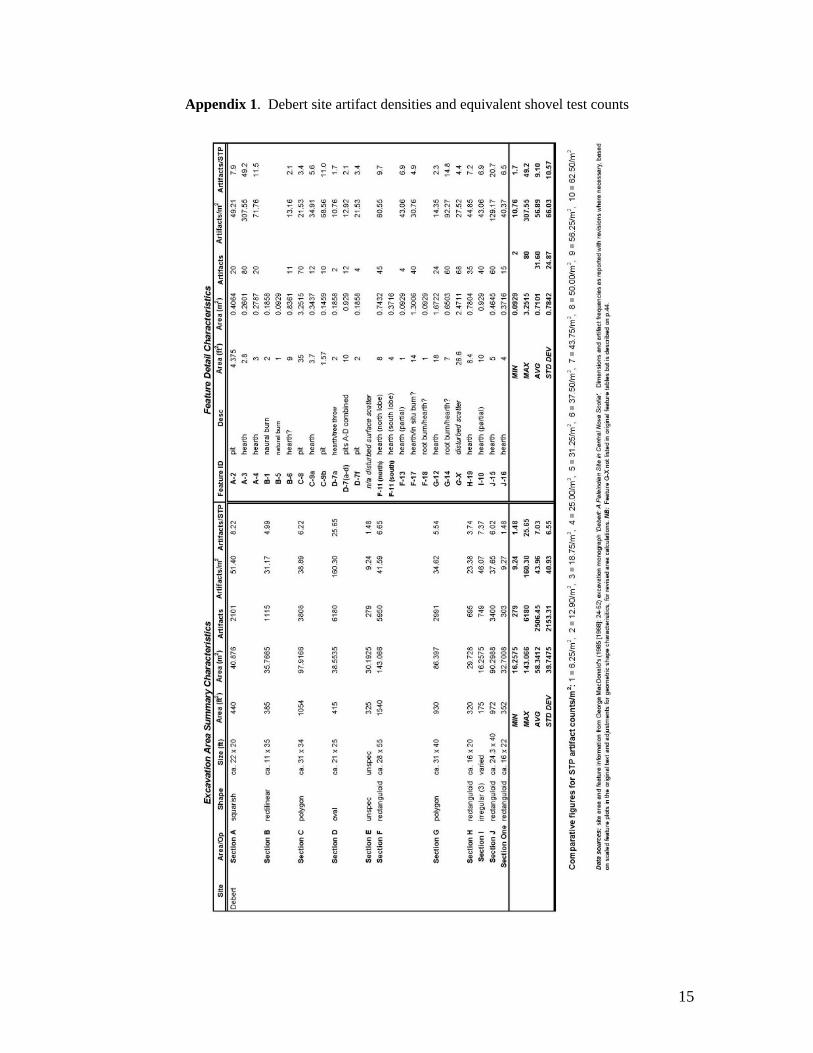
Appendix 1. Debert site artifact densities and equivalent shovel test counts

16
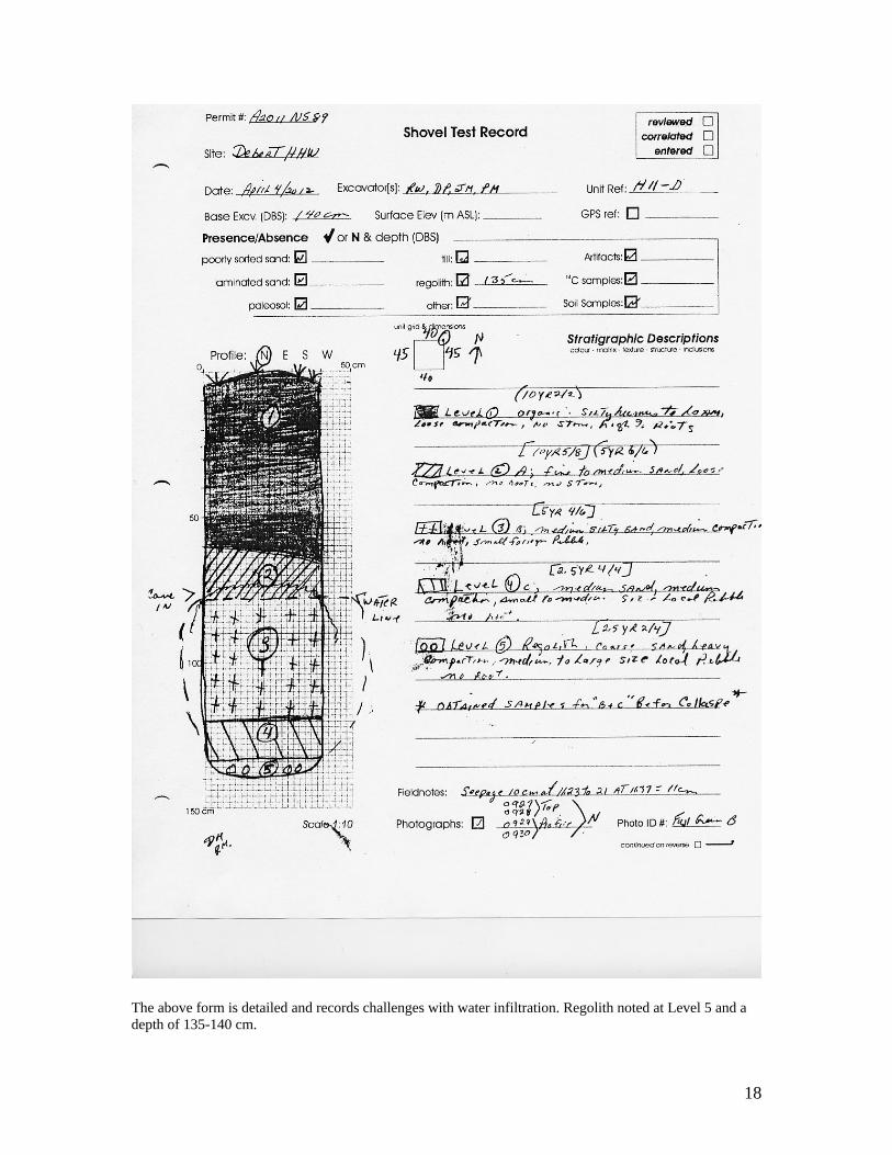
Appendix 2. Sample Shovel Test Record Forms and Shovel Test Photograph

17
18
The above form is detailed and records challenges with water infiltration. Regolith noted at Level 5 and a depth of 135-140 cm.
19
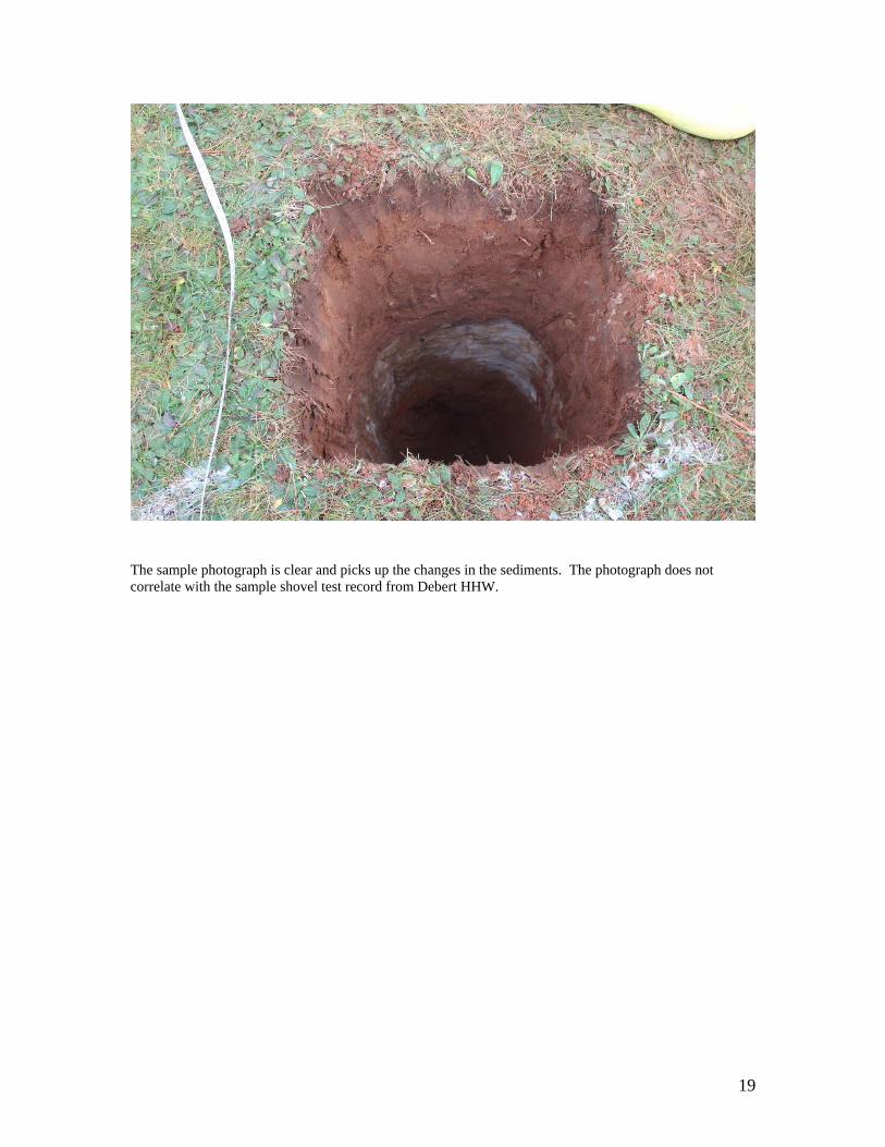
The sample photograph is clear and picks up the changes in the sediments. The photograph does not correlate with the sample shovel test record from Debert HHW.

20
Appendix 3.
Process for the Issuance of Archaeological Heritage Research Permits for the Debert Lands and the review of Impact Assessment Reports
The following is a detailed outline of the process that was agreed to in general by the Minister of Communities, Culture and Heritage (CC&H) and the Assembly of Nova Scotia Mi’kmaq Chiefs in the Memorandum of Understanding (MOU). The intent of this Appendix is to provide for a joint Province of Nova Scotia – Mi’kmaq of Nova Scotia process for input and recommendation to be made to the Minister of CC&H on heritage research permit applications for Category C Archaeological Resource Impact Assessments on the Debert Lands and the Impact Assessment Reports produced as a result of those permits.
Nova Scotia and the Mi’kmaq of Nova Scotia will create a standing Review Committee consisting of one representative from each Party who holds a sufficiently recognized archaeological background to review and apply the Archaeological Standards, or who has direct access to a qualified archaeologist to assist in applying the standards. The Review Committee will agree to procedures that are consistent with this MOU and the Archaeological Standards.
Part I – Permit Application and Approval Process for Phase I Archaeological Testing
1. Immediately upon receipt of a complete Permit Application to conduct a Category C Archaeological Resource Impact Assessment by Communities, Culture and Heritage from a prospective Permit Holder, a copy of the application will be forwarded to the Review Committee as per the notice provisions outlined in the MOU. The Review Committee will be comprised of the Coordinator of the Special Places Program (CC&H), the Curator of Archaeology (CC&H), and representatives from the Confederacy of Mainland Mi’kmaq (CMM) and Kwilmu’kw Maw-klusuaqn Negotiations Office (KMKNO). The Coordinator of the Special Places Program will act as the point of contact between the Review Committee and the Minister when input and recommendations are made. 2. Within ten (10) working days of receiving a complete Permit Application, the Review Committee will mutually determine whether or not the Permit Application is in compliance with the Archaeology Standards and, if in compliance, the Review Committee will make a recommendation to the Minister who will then make a decision with respect to the Permit Application. The prospective Permit Holder will be notified in writing and the process moves to Part II of this process. 3. If the Review Committee mutually determines that the Permit Application is not in compliance with the Archaeology Standards, a recommendation will be made to the

21
Minister with respect to the application within ten (10) working days of receiving the Permit Application. Should the Minister make the decision to deny the permit application, the Review Committee will provide a report to the prospective Permit Holder and Proponent outlining the deficiencies in the application and specifying the necessary changes. The prospective Permit Holder will be required to satisfactorily address deficiencies in a new Permit Application before a recommendation will be made to the Minister with respect to the Permit Application. 4. If the Review Committee cannot mutually agree on a recommendation to be made to the Minister regarding the Permit Application, they will explore options to achieve consensus. The Review Committee may jointly contact the prospective Permit Holder to seek clarity or further data regarding the Permit Application. In the event that the Review Committee is unable to reach mutual agreement on the recommendation to be made to the Minister, the process moves to the Dispute Resolution section of this appendix. Part II – Review of Phase I Archaeological Testing
5. Upon formal receipt of permit approval in writing from the Minister, the Permit holder is authorized to commence fieldwork on behalf of the Proponent as proposed in the application and in accordance with Section I of the Archaeology Standards.
6. Immediately upon receipt of a Phase I Archaeological Impact Assessment report by Communities, Culture and Heritage from a Permit Holder, a complete copy of the assessment documentation will be forwarded to the Review Committee as per the notice provisions outlined in the MOU.
7. The Review Committee will determine whether or not the Phase I Archaeological Impact Assessment report is in compliance with the Archaeology Standards. If it is in compliance, the Review Committee will make a recommendation in writing to the Minister to accept the Phase I Archaeological Testing report.
8. If the Review Committee mutually determines that the Phase I Archaeological Impact Assessment report is not in compliance with the Archaeology Standards, a recommendation will be made to the Minister that it not be accepted. Should the Minister decide not to accept the report, the Review Committee will provide a report to the Permit Holder and Proponent outlining the deficiencies in the Phase I Archaeological Impact Assessment report and specify required changes which must be addressed by the Permit Holder prior to the Review Committee making a recommendation to the Minister to accept the report.
9. If the Review Committee cannot mutually agree on approval of the Phase I Archaeological Testing report, they will explore options to achieve consensus. The Review Committee may jointly contact the prospective Permit Holder to seek clarity or further data. In the event that the Review Committee cannot agree on options, the process moves to the Dispute section of this Appendix.

22
10. Upon the submission of an acceptable report to Communities, Culture and Heritage, land that has been the focus of archaeological impact testing according to the Debert Standards may be cleared for future soil disturbance. Land is not considered cleared until:
a. A final report has been submitted under the terms of the Heritage Research Permit which fulfils the conditions identified in the Standards, and is approved by the Minister for CC&H (or his/her designate), as long as the designate is not a member of the review committee. b. Communities, Culture and Heritage has issued a letter of clearance as well as a map indicating the lands that are clear for soil disturbance. When there are conditions associated with the clearance of lands, these will be outlined in the clearance letter. It is expected that all conditions will be met for any future soil disturbance.
If the Review Committee is satisfied that no Mi’kmaw heritage archaeological evidence was found during Phase I Archaeological Impact Assessment testing, Communities, Culture and Heritage will issue a letter of clearance and excavation or soil disturbance may proceed by the Proponent. A letter of clearance indicates that a satisfactory archaeological Impact Assessment was completed and based on the report Mi’kmaw heritage archaeological resources were not found by the permit holder.
11. If Mi’kmaw heritage archaeological evidence is found, Communities, Culture and Heritage may require the Proponent and the Permit Holder to undertake a Phase II Archaeological Resource Impact Assessment pursuant to the Archaeology Standards. The Review Committee will determine any specific requirements for the assessment pursuant to the Archaeology Standards. Any archaeological investigations for a Phase II Archaeological Resource Assessment will be authorized under a separate Phase II Permit.
Part III - Permit Application and Approval for Phase II Archaeological Resource Assessment 12. The permit approval process for Phase II Permit Application follows the process outlined in Part I of this Appendix.
13. The review of a Phase II Archaeological Impact Assessment report will be in accordance with the process outlined in Part II of this Appendix. The Review Committee will undertake a critical review of all findings to determine the basis and means of any future archaeological intervention which may be required to mitigate potential impacts on the identified archaeological resources as outlined in Section II of the Archaeology Standards.
14. If the Review Committee accepts the Phase II Archaeological Impact Assessment
report and determines that no further mitigation is required, a joint recommendation will be made to the Minister to accept the report and to issue a letter confirming that no significant archaeological resources are present on the area of Debert Lands tested,

23
Communities, Culture and Heritage will issue a letter of clearance and excavation or soil disturbance may proceed by the Proponent.
15. Any outstanding archaeological concerns requiring additional archaeological assessment not addressed in the letter of clearance must be addressed through a separate Permit Application. Part IV – Disputes
16. Should the Review Committee be unable to agree on a joint recommendation to be made to the Minister in relation to a Permit Application or an Impact Assessment Report, and the Review Committee has made best efforts to explore options to address the disagreement, the Review Committee will notify the Parties in writing. The Parties will then create a joint CC&H - Mi’kmaw Dispute Committee. The Dispute Committee will agree to procedures that are consistent with this MOU and the Archaeological Standards.
The Dispute Committee will be comprised of three (3) individuals appointed by CC&H of which a minimum of one (1) must have a background in Palaeo period archaeology and three (3) individuals appointed by the Mi’kmaw parties of which a minimum of one (1) must have a background in Palaeo period archaeology. 17. The Review Committee will provide a report to the Dispute Committee outlining the issues of disagreement. The report will be one document and will include the perspectives of each representative, suggested options for resolution and all documentation relevant to the issue. The Dispute Committee may request third party input as it deems necessary. Decisions of the Dispute Committee will be by majority vote. 18. If the Dispute Committee agrees on a recommendation to be made to the Minister, this will be provided to the Minister within twenty (20) working days of receiving the report of the Review Committee. 19. If the Dispute Committee cannot agree on a recommendation to be made the to the Minister, the Dispute Committee will refer the matter to the Minister for a decision and will provide a report to the Minister outlining the issues of disagreement within twenty (20) working days of receiving the report of the Review Committee. The report will be one document and will include the perspectives of each representative, suggested options for resolution and all documentation relevant to the issue. 20. Should the Dispute Committee be unable to make a recommendation to the Minister regarding the Archaeological Impact Assessment report when Palaeo-Indian period archaeological material has been found, the Department of Communities, Culture and Heritage will consult with the Mi’kmaq of Nova Scotia, within a reasonable amount of time, before referring the matter to the Minister for a decision.

24
21. The Parties acknowledge that Nova Scotia and the Mi’kmaq have agreed to a consultation process for addressing consultation matters related to possible infringements on claimed or asserted Mi'kmaw rights and/or title. While this MOU will strengthen the relationship between Nova Scotia and the Mi’kmaq in matters of archaeological investigations related to the development of the former NSBI lands, the parties are at liberty at any time to call upon the other Party to consult about matters forming the subject of this Memorandum of Understanding and/or about any decision Nova Scotia is proposing to make with respect to these lands. 22. If matters relevant to this Memorandum of Understanding and/or a decision made by Nova Scotia is/are placed before a court of law or administrative tribunal, the Parties are at liberty to seek to enter into evidence before the court or tribunal this Memorandum of Understanding and all documents, discussions, negotiations, processes and records created or carried out pursuant to it.