National Trails Training Partnership Your resource for trails training.
REVISED
Girdwood Trails CommitteeRE: GTP Public Review Draft
Recommended Changes
October 5, 2021
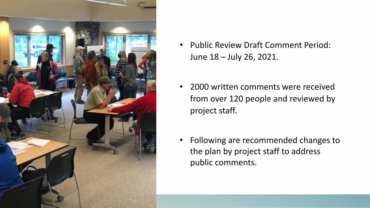
• Public Review Draft Comment Period: June 18 – July 26, 2021.
• 2000 written comments were received from over 120 people and reviewed by project staff.
• Following are recommended changes to the plan by project staff to address public comments.

T1: Separated Grade Crossing: Railroad Bridge at Alyeska HighwayNO SUBSTANTIVE CHANGE RECOMMENDEDSlight narrative change to urge the DOT to include this improvement as part of the Alyeska Highway/Seward Highway intersection project, but overall, no substantive change to intent.
T4: Ruane Road Trail Connection to Lower IditarodNO CHANGE RECOMMENDED
Lower Valley Recommended Changes
B1: Glacier Creek Trail Bridge – Lower ValleyNO SUBSTANTIVE CHANGE RECOMMENDEDRecommend adding language to indicate that it would be beneficial to coordinate with the Alaska Railroad so that if/when the trestle is ever rebuilt over Glacier Creek maybe the future crossing can include a safe pedestrian connection – a future collocated bridge could also be part of the proposed southern extension of the Seward Highway Trail. Also recommend adding language that if this level of coordination is not successful, the most feasible location for a bridge in the lower valley should be identified.

T5: Beaver Pond to Alyeska HighwayNO SUBSTANTIVE CHANGE RECOMMENDEDWHY: There were comments indicating this connection adjacent to residential property was not desired. Additionally, there were comments indicating a concern for safety if a trail user crossed the Alyeska Highway to connect to T3. T3 is recommended to be removed from the plan (see above). No substantive change is recommended because if housing is developed on Tract 18A and a roadway constructed on the Juniper Drive easement, it is prudent to ensure that pedestrian/trail connectivity is considered if future development proceeds. T5 should only be considered a priority for development if Tract 18A is developed.
T3: Lower Valley Trail Loop ConnectionCHANGE RECOMMENDED – Remove the upper portion of the trail from Ruane to residential area and develop the connection from Ruane, south to the Lower Iditarod.WHY: Comments indicated that the upper portion of this trail was too impactful on the environment, the neighborhood, and redundant (already served by the Iditarod route). This change would also require the removal of B2. However, the lower loop would be a welcome addition for residents of the lower valley.
Lower Valley Recommended Changes
B2: California Creek BridgeCHANGE RECOMMENDED – Remove this project from the plan. See project T3. WHY: See above.
TH 3CHANGE RECOMMENDED – Remove this trailhead from the plan.WHY: Comments indicated there was not public support for this trailhead.

Lower Valley Recommended Changes
T2: Wagon Trail – Lower Joe Danich ConnectionCHANGE RECOMMENDED – Remove this project from the plan.WHY: Comments exhibited concerns about the environmental and financial feasibility of developing this connection through the wetlands of the lower valley. Two forks of the trail in the draft are redundant.
B3: Virgin Creek BridgeNO CHANGE RECOMMENDED
NS1: Virgin Creek Natural SpaceCHANGE RECOMMENDEDRecommend adjusting the boundary of NS1. The eastern boundary should extend and include the Wagon Trail. The western boundary should be adjusted to remove the Joe Danich Trail from NS1. ADD a trail project to the plan that brings the Joe Danich up to a Class 3 trail constructed to the bicycle design parameter and relocate out of wetlands to uplands. ADD trail project to the plan to construct neighborhood connector trail (Class 3, bicycle design parameters, constructed in uplands) from the Turin and/or Carlina Drive cul-de-sacs to connect to the Joe Danich trail. NS1, with the adjusted boundary, remains non-mechanized with trails that are no greater than Class 2. WHY: Comments indicate that residents want a multi-use alternative trail to connect from the lower valley to the upper valley without using the road system. A Class 3 designation provides a sustainable connection to neighborhoods. The eastern boundary shift better aligns with a primitive experience for the Wagon Trail.

Lower Valley Recommended Changes
Public Review Draft Recommended Change

Middle Valley Recommended Changes
MB1: Beaver Pond MB AreaCHANGE RECOMMENDEDRecommend removing MB1 from the plan. WHY: There is not consensus about this project. Needs more discussion – if included in the plan MB1 shall be developed in consultation with the Girdwood Trails Committee only after MB2 is complete. If MB1 is removed, user conflicts on Abe’s and California Creek Trails still needs to be addressed.
T7: Crow Creek Road to Beaver Bond TrailCHANGE RECOMMENDED – DISCUSS IN CONCERT WITH MB1WHY: Comments do not indicate consensus for MB1. If MB1 is removed from the plan, T7 should also be removed.

Middle Valley Recommended Changes
T8: Toe Slope Trail – California Creek to Iditarod TrailNO SUBSTANTIVE CHANGE RECOMMENDEDRecommend adding a bridge over California Creek. Recommend adding as a new bridge project.
T9: Crow Creek Neighborhood TrailsNO CHANGE RECOMMENDEDAlthough comments do not indicate consensus, it is recommended to leave these trails in the plan. WHY: This trail network is already included in an adopted plan, the Crow Creek Neighborhood Land Use Plan. Additionally, residential development is currently being considered for this area (Holtan Hills) – it will be important to require the development of trails within the neighborhood as well as connectivity out of the neighborhood to the Upper Iditarod and other important community connections.
Girdwood CemeteryCHANGE RECOMMENDED – ADD a trailhead at the Girdwood Cemetery and a discussion about how the proposed cemetery trails and cemetery phasing plan align with the trail network.WHY: It makes sense to coordinate between the trail system and the Cemetery project. The parking area can serve multiple uses and the Cemetery trails should connect to the larger trail system.

Upper Valley Recommended Changes
T10: Cross Valley TrailCHANGE RECOMMENDED – Relocate this proposed trail and edit to Class 3 (Bicycle Design Parameter).WHY: The proposed location of this trail should be adjusted to better align with and connect to B5. In addition, the trail classification should be adjusted to Class 3 to better match the trails to which T10 is intended to connect including the Upper Iditarod (Class 3). This alignment also better aligns with the future Holtan Hills development.
T13: Upper Valley Multi-Use TrailCHANGE RECOMMENDED – Remove this trail and ADD the Forest Loop concept back into the plan.WHY: Public comments indicated that the area was crowded with trails and the route as indicated in the draft would be too damaging to wetlands. There was not consensus or support for T13. See NS2 for more recommendations.
NS2: Stumpy’s Natural SpaceCHANGE RECOMMENDEDRecommend adjusting the boundary of NS2. Expand the boundary to the east to extend up to but not including the Snowcat Trail and the groomed section of Stumpy’s winter trail. WHY: There isn’t consensus for T13 and the wetlands are better suited for a more primitive experience.
B5: Glacier Creek Trail Bridge – North of Airport LandNO SUBSTANTIVE CHANGE RECOMMENDEDAdd language to strengthen the concept that this bridge should connect directly to T10.

Upper Valley Recommended Changes
Public Review Draft Recommended Change
ADD FOREST LOOP

Mountain Bike Areas Description on Page 35CHANGE RECOMMENDED – Remove Mountain Biking Areas Title and replace with the following:Areas for Mountain Biking Trail DevelopmentThe areas identified for mountain biking trail development don’t limit the development of other recreational activities in the area.
Natural Spaces Description on Page 35CHANGE RECOMMENDED – Remove Natural Space paragraph and replace with the following:Areas for Primitive TrailsOne way in which this plan improves the balance and diversity of Girdwood’s trail system is by identifying areas where primitive trails are desired. Areas that prioritize primitive trails serve a variety of purposes, including both conservation and recreation, where non-mechanized recreation activities like trail walking, running, hiking, skiing, snowshoeing, orienteering, foraging, wildlife viewing, education, solitude, and meditation are the primary uses.
Natural Space Network & Mountain Bike Areas – Throughout the documentCHANGE RECOMMENDED – REMOVE all references to Natural Space Network and Mountain Bike Areas and adjust language to be consistent with the recommendations above.
WHY: Comments indicated that the use of the terms “mountain bike areas” and “natural space areas” gives the perception that the trailplan is making land use recommendations that will conflict with the Girdwood Area Plan, which is currently in development.

W H AT ’ S N E X T ?
• October 5 – November 2: GTC member review
• November 2 GTC Meeting: Committee member recommendations for changes.
• November: Project Team will incorporate changes
• Land Use Committee, GBOS, HLBAC, PZC

GIRDWOOD TRAILS PLAN Public Review Draft – Recommendations for Changes/Edits
The Girdwood Trails Plan Public Review Draft was available for public review from June 18 – July 26, 2021. Over the course of the comment period, approximately 2000 written comments were received from over 120 people. The comments were organized into the following categories:
1. Comments from the comment cards 2. Project specific comments from the comment cards 3. Comments received by email during the comment period (not provided in the comment card
format)
The comments were then reviewed. Following are recommended changes to the plan by project staff to address public comments.
NEW TRAIL PROJECT RECOMMENDATIONS
T1: Separated Grade Crossing: Railroad Bridge at Alyeska Highway NO SUBSTANTIVE CHANGE RECOMMENDED Slight narrative change to urge the DOT to include this improvement as part of the Alyeska Highway/Seward Highway intersection project, but overall, no substantive change to intent.
T2: Wagon Trail – Lower Joe Danich Connection CHANGE RECOMMENDED – Remove this project from the plan. Comments exhibited concerns about the environmental and financial feasibility of developing this connection through the wetlands of the lower valley. Two forks of the trail in the draft are redundant.
T3: Lower Valley Trail Loop Connection CHANGE RECOMMENDED – Remove the upper portion of the trail from Ruane to residential area and develop the connection from Ruane, south to the Lower Iditarod. Comments indicated that the upper portion of this trail was too impactful on the environment, the neighborhood, and redundant (already served by the Iditarod route). This change would also require the removal of B2. However, the lower loop would be a welcome addition for residents of the lower valley.
T4: Ruane Road Trail Connection to Lower Iditarod NO CHANGE RECOMMENDED
T5: Beaver Pond to Alyeska Highway NO SUBSTANTIVE CHANGE RECOMMENDED There were comments indicating this connection adjacent to residential property was not desired. Additionally, there were comments indicating a concern for safety if a trail user crossed the Alyeska Highway to connect to T3. T3 is recommended to be removed from the plan (see above). No substantive change is recommended because if housing is developed on Tract 18A and a roadway constructed on the Juniper Drive easement, it is prudent to ensure that pedestrian/trail connectivity is considered if future development proceeds. T5 should only be considered a priority for development if Tract 18A is developed. (Change the name of the project)

T6: Barren Avenue to Alyeska Highway NO CHANGE RECOMMENDED
T7: Crow Creek Road to Beaver Bond Trail CHANGE RECOMMENDED – DISCUSS IN CONCERT WITH MB1 Comments do not indicate consensus for MB1. Language should be added to the project description to indicate that this trail should only be constructed when/if MB3 is developed. T7 will provide better safety and reduce conflict by separating uses and providing a ‘down-route’ for bikes using MB3 if constructed.
T8: Toe Slope Trail – California Creek to Iditarod Trail NO SUBSTANTIVE CHANGE RECOMMENDED Recommend adding a bridge over California Creek. Recommend adding as a new bridge project.
T9: Crow Creek Neighborhood Trails NO CHANGE RECOMMENDED Although comments do not indicate consensus, it is recommended to leave these trails in the plan. This trail network is already included in an adopted plan, the Crow Creek Neighborhood Land Use Plan. Additionally, residential development is currently being considered for this area (Holtan Hills) – it will be important to require the development of trails within the neighborhood as well as connectivity out of the neighborhood to the Upper Iditarod and other important community connections.
T10: Cross Valley Trail CHANGE RECOMMENDED – Relocate this proposed trail and edit to Class 3 (Bicycle Design Parameter). The proposed location of this trail should be adjusted to better align with and connect to B5. In addition, the trail classification should be adjusted to Class 3 to better match the trails to which T10 is intended to connect including the Upper Iditarod (Class 3). This alignment also better aligns with the future Holtan Hills development.
T11: Arlberg Connection to Winner Creek Trail NO CHANGE RECOMMENDED
T12: Glacier Canyon Rim Trail NO CHANGE RECOMMENDED
T13: Upper Valley Multi-Use Trail CHANGE RECOMMENDED – Remove this trail and ADD the Forest Loop concept back into the plan. Public comments indicated that the area was crowded with trails and the route as indicated in the draft would be too damaging to wetlands. There was not consensus or support for T13. See NS2 for more recommendations.
T14: Snowcat Trail Improvements NO SUBSTANTIVE CHANGE RECOMMENDED Recommend adding language so support the relocation or reconstruction of this trail out of the wetlands wherever possible.

BRIDGE PROJECT RECOMMENDATIONS
B1: Glacier Creek Trail Bridge – Lower Valley NO SUBSTANTIVE CHANGE RECOMMENDED Overall, this project was recognized as a good crossing to connect lower valley trails. Recommend adding language to indicate that it would be beneficial to coordinate with the Alaska Railroad so that if/when the trestle is ever rebuilt over Glacier Creek maybe the future crossing can include a safe pedestrian connection – a future collocated bridge could also be part of the proposed southern extension of the Seward Highway Trail. Also recommend adding language that if this level of coordination is not successful, the most feasible location for a bridge in the lower valley should be identified.
B2: California Creek Bridge CHANGE RECOMMENDED – Remove this project from the plan. See project T3.
B3: Virgin Creek Bridge NO CHANGE RECOMMENDED
B4: Improve Connectivity at Glacier Creek Bridge at Alyeska Highway NO CHANGE RECOMMENDED
B5: Glacier Creek Trail Bridge – Middle Valley - North of Airport Land NO SUBSTANTIVE CHANGE RECOMMENDED Add language to strengthen the concept that this bridge should connect directly to T10.
B6: Glacier Creek Trail Bridge – Upper Valley Hand Tram NO CHANGE RECOMMENDED
TRAILHEAD PROJECT RECOMMENDATIONS
TH 1, TH2, TH4, TH5, TH6, TH8, TH9, TH10, TH11, TH12, TH13 NO CHANGE RECOMMENDED
TH 3 CHANGE RECOMMENDED – Remove this trailhead from the plan. Comments indicated there was not public support for this trailhead.
TH7 NO SUBSTANTIVE CHANGE RECOMMENDED Ensure that this trailhead is labeled correctly as Moose Meadows Trailhead.
Girdwood Cemetery CHANGE RECOMMENDED – ADD a trailhead at the Girdwood Cemetery and a discussion about how the proposed cemetery trails and cemetery phasing plan align with the trail network.
NATURAL SPACE PROJECT RECOMMENDATIONS
Natural Spaces Description on Page 35 CHANGE RECOMMENDED – Remove Natural Spaces paragraph and replace with the following: Areas for Primitive Trails: One way in which this plan improves the balance and diversity of Girdwood’s trail

system is by identifying areas where primitive trails are desired. Areas that prioritize primitive trails serve a variety of purposes, including both conservation and recreation, where non-mechanized recreation activities like trail walking, running, hiking, skiing, snowshoeing, orienteering, foraging, wildlife viewing, education, solitude, and meditation are the primary uses. Natural Space Network – Throughout the document CHANGE RECOMMENDED – REMOVE all references to Natural Space Network and adjust language to be consistent with the recommended language above.
NS1: Virgin Creek Natural Space CHANGE RECOMMENDED Recommend adjusting the boundary of NS1. The eastern boundary should extend and include the Wagon Trail. The western boundary should be adjusted to remove the Joe Danich Trail from NS1. ADD a trail project to the plan that brings the Joe Danich up to a Class 3 trail constructed to the bicycle design parameter and relocate out of wetlands to uplands. ADD trail project to the plan to construct neighborhood connector trail (Class 3, bicycle design parameters, constructed in uplands) from the Turin and/or Carlina Drive cul-de-sacs to connect to the Joe Danich trail. NS1, with the adjusted boundary, remains non-mechanized with trails that are no greater than Class 2. Comments indicate that residents want a multi-use alternative trail to connect from the lower valley to the upper valley without using the road system. A Class 3 designation provides a sustainable connection to neighborhoods. The eastern boundary shift better aligns with a primitive experience for the Wagon Trail.
Public Review Draft Recommended Change
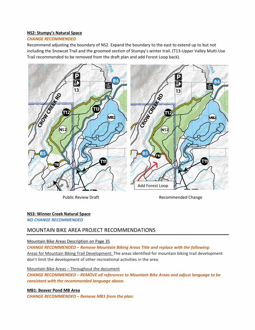
NS2: Stumpy’s Natural Space CHANGE RECOMMENDED Recommend adjusting the boundary of NS2. Expand the boundary to the east to extend up to but not including the Snowcat Trail and the groomed section of Stumpy’s winter trail. (T13-Upper Valley Multi-Use Trail recommended to be removed from the draft plan and add Forest Loop back).
NS3: Winner Creek Natural Space NO CHANGE RECOMMENDED
MOUNTAIN BIKE AREA PROJECT RECOMMENDATIONS
Mountain Bike Areas Description on Page 35 CHANGE RECOMMENDED – Remove Mountain Biking Areas Title and replace with the following: Areas for Mountain Biking Trail Development: The areas identified for mountain biking trail development don’t limit the development of other recreational activities in the area.
Mountain Bike Areas – Throughout the document CHANGE RECOMMENDED – REMOVE all references to Mountain Bike Areas and adjust language to be consistent with the recommended language above.
MB1: Beaver Pond MB Area CHANGE RECOMMENDED – Remove MB1 from the plan:
Public Review Draft Recommended Change
Add Forest Loop

There is not consensus about this project. Needs more discussion – if included in the plan MB1 shall be developed in consultation with the Girdwood Trails Committee only after MB2 is complete. If MB1 is removed, user conflicts on Abe’s and California Creek Trails still needs to be addressed.
MB2: Near the Nordic 5K CHANGE RECOMMENDED – ADD the following sentences: MB2 should be the first mountain bike area developed in the Girdwood Valley, prior to MB1 and MB3. All trails in MB2 should minimize impacts to the Winner Creek Trail viewshed. A variety of trails should be developed for a diversity of users’ abilities so that bike pushing and e-bike assist is not necessary for the average rider.
MB3: End of Snowcat Trail CHANGE RECOMMENDED – ADD the following sentence: Of the mountain bike areas identified in this plan, MB3 should be developed last.
Girdwood Trails Draft Plan Public Review Comment Collection Process
Public participation
• The public comment period will be June 18th to July 26th, 2021
• The draft plan will be presented to the Public on June 24th through an open house presentation at the Girdwood Community
• A webpage will be established for the Draft Plan for the public to get the plan and instruction on how to give comments
• Questionnaire forms will be provided to the public
• All comments for the draft plan will be due by July 26th, 2021
Methods for Analyzing the Public comments received:
• All comments received during the public comment period will be reviewed and either be acknowledged as read or replied to if warranted.
• Qualitative methods will be used to analyze the comments, including input received throughout the process of development of the draft plan (i.e. stake holder interviews, prior public meetings, earlier written comments, subcommittee meetings).
• The comments and other input will be organized first into broad categories, then into sub-categories. These categories or codes will reflect the stated goals of the plan.
• Data analysis will require finding patterns and themes for decision making.
• Decisions will have to be made to find balance of the public desires and requests of projects, concepts, and ideas to be included in the staff recommended changes for the draft plan.
Deliverables from Public Comment Collection:
• Summary document of the public comments
• A presentation and memo with staff recommended changes of the draft plan will be presented to Girdwood Trails Plan subcommittee for their consideration.
• In addition to qualitative review noted above, the following elements are integral to the staff and contractor recommendations:
--development of several HLB parcels is now under consideration and housing need indicates that this development is likely in the coming 5 years.
-- trail development in locations of likely infrastructure development that will require new access to existing trails (Holtan Hills, Tract 18, Cemetery)

-- recommend trail type and class that creates sustainable multi-use connector trails in keeping with community pedestrian culture.
--creates loops, interconnectivity, and multiple access points to encourage neighborhood access to all trails and reduces need for parking lots for local trail users.
--retains Natural Space designation for spaces within the community
--need for plan to remain relevant and useful for the coming 5+ years as the community develops and grows and trail user needs evolve.

Yellow line indicates proposed narrow gauge grooming route. An outer Viewscape loop similar to Moose Meadow to continue up valley connecting the meadows. This could increase the hiking, biking, and skiing user-days with a lighter and more maneuverable grooming machine. This is a response to the positive feedback of the Moose Meadow loop and to create a safe route for the increasing number of multi-use trail users in Girdwood.
Color Key:Yellow Proposed Narrow gauge grooming (multi-use)Red 5K directional trail (ski only)Purple CPG Snow cat trail (multi use)Green Winner Creek ungroomed (multi use)Light blue Traditional snow machine grooming (multi-use)
10/1/21

October 5 2021 Report
Girdwood Trails Committee
Updates and other business: • Girdwood Trails Management Plan Subcommittee: updated version is posted on the GBOS website.
Management Plan meetings are on hold until Trails Master Plan is complete.
• Girdwood Trails Master Plan comment period closed, review of comments ongoing and proposal to be discussed in fall meeting cycle.
• Imagine! Girdwood Imagine! Girdwood will continue to meet virtually through the end of 2021. Group is focused on technical analysis and next steps. Funds are needed to continue the effort; Huddle is to provide a quote to establish fundraising goals. Visit imaginegirdwood.org
• Financial Report Received donation from Bob and Sherry Dugan for creation, fabrication and installation of signs on the middle Iditarod National Historic Trail. Thank you Bob and Sherry!
Girdwood Trails Committee Financial Report As of September 30, 2021 Account with Girdwood Inc. $48,642.85 Last Report 08/31/2021 September, 2021 Transactions to Date: Payment to Hehnlin Lower INHT Trail Work ($8,632.28) Dugan Donation Mid INHT Trail Signs $1,555.00 Account Balance
September 30, 2021 $41,565.57 No Amounts Reserved at this time
Grants Status report: Alaska Community Foundation Trail Care Fund: Received $1375 to put toward Ruane connector to Lower INHT. Project is now complete and grant close-out has been sent in for processing. KMTA Stumpy’s Winter Trail Interp sign: Received 1:1 matching grant requested from KMTA for Stumpy’s signs. RTP $75,000 for INHT Phase 2 from Industrial Park to Karolius & interp signs: awarded with 90:10 match, started work in July. Reimbursement of $3702.56 has been submitted and approved. Final reimbursement and closeout of project is pending. KMTA Virgin Creek Falls Trail: $7,300 awarded with 1:1 match, Section 106 review complete. Work is 95% complete through summer parks and rec crew in 2020 and 2021 as well as 3 member SCA crew. Pending is some gravel distribution at the top of the trail and fabrication and installation of Trailhead Interp sign (spring 2022). Reimbursement will be initiated shortly.

Other Girdwood Trail Partners Updates Kenai Mountains Turnagain Arm Heritage Area (KMTA): Thank you for support letters. We’ll keep you posted on reauthorization of KMTA and funding for all the National Heritage Areas. KMTA welcomes new Executive Director, Rachel Blakeslee, who will join KMTA officially on October 11. Deadline for fall photo contest is extended to end of October. Find more info and submit entries here: https://kmtacorridor.org/photo-contests/ Girdwood Nordic Ski Club (GNSC): The Girdwood Nordic Ski Club has purchased a new Snow Dog narrow gauge groomer to help with logistics and save Ben Kohler from driving back-and-forth all winter. This should help the response time to grooming the narrow gauge trails in the meadow at the same time as lower the lower valley and Bird-to-Gird trail. Girdwood marathon on Saturday, October 2 has 190 hardy participants signed up.
Bikewood: No report
Land Use and Girdwood Board of Supervisors: Review minutes on line at: www.muni.org/gbos.