Revised for Acceptance for the Comptroller of Water … · Revised for Acceptance for the...
37
Alouette Project Water Use Plan (April 15, 2009) Revised for Acceptance for the Comptroller of Water Rights
Transcript of Revised for Acceptance for the Comptroller of Water … · Revised for Acceptance for the...

Alouette Project Water Use Plan (April 15, 2009)
Revised for Acceptance for the Comptroller of Water Rights

Alouette Project - Water Use Plan
Generation Resource Management April 15, 2009
Alouette Project Water Use Plan (April 15, 2009)
Revised for Acceptance for the Comptroller of Water Rights


Alouette Project - Water Use Plan
Generation Resource Management April 15, 2009
Preface
The water use planning review process for BC Hydro’s Alouette Project was initiated in May 2005 and completed in August 2006. It involved a review of all data collected since implementation of the September 1996 Alouette Project Water Use Plan, an assessment of new knowledge in the basin, including changes in resource values, and a refinement in proposed conditions for the operation of BC Hydro’s Alouette Project.
The proposed conditions in the 2009 Water Use Plan for the operation of BC Hydro’s Alouette facilities reflect the consensus recommendations of the August 2006 Alouette Project Water Use Plan Review Consultative Committee Report. These conditions, once accepted by the Comptroller of Water Rights, will replace operations previously governed by a Section 39 Order issued October 3, 1997 based on the September 25th, 1996 Alouette Water Use Plan.
BC Hydro thanks all of those who participated in the process that led to the production of the Water Use Plan for their effort and dedication.
The proposed conditions for the operation of BC Hydro’s Alouette Project facilities will not come into effect until implemented under the British Columbia Water Act.

Alouette Project - Water Use Plan Page i
Generation Resource Management April 15, 2009
Table of Contents
1.0 INTRODUCTION ............................................................................................... 1
2.0 DESCRIPTION OF WORKS............................................................................. 2
2.1 Location ..................................................................................................... 2
2.2 Existing Works ........................................................................................... 3
2.2.1 Earthfill Dam, Spillway, and Low Level Outlet............................. 3
2.2.2 Intake Headworks, Power Tunnel, Adit and Powerhouse.................................................................................... 4
3.0 ALOUETTE RIVER HYDROLOGY................................................................ 5
4.0 OPERATING CONDITIONS FOR FACILITIES........................................... 5
4.1 Role of Facility in BC Hydro’s System ...................................................... 5
4.2 Water Use at Alouette Project ................................................................... 5
4.3 Emergencies and Dam Safety .................................................................... 6
4.4 Operation of Works for Diversion and Use of Water ................................ 6
4.4.1 Base flow release to Alouette River ............................................... 7
4.4.2 Spring Surface Release .................................................................. 7
4.4.3 Power Tunnel Operations for Flood Mitigation............................ 8
4.4.4 Crest Gate Operation for Flood Control....................................... 8
4.4.5 Flushing Flows .............................................................................. 9
4.4.6 Ramping Rates ............................................................................... 9
4.4.7 Turbine Operations........................................................................ 9
4.5 Operation of Storage Works ...................................................................... 9
4.5.1 Spring Surface Release ................................................................ 10
4.5.2 Recreation Season Targets on Alouette Lake Reservoir.............. 10
5.0 PROGRAM FOR ADDITIONAL INFORMATION ..................................... 10
6.0 IMPLEMENTATION OF RECOMMENDATIONS..................................... 12
7.0 EXPECTED WATER MANAGEMENT IMPLICATIONS ......................... 12
7.1 Other Licensed Uses of Water ................................................................. 12
7.2 Riparian Rights ........................................................................................ 12
7.3 Fish Habitat ............................................................................................. 13
7.4 Wildlife Habitat........................................................................................ 13
7.5 Flood Mitigation ...................................................................................... 13

Alouette Project - Water Use Plan Page ii
Generation Resource Management April 15, 2009
7.6 Recreation ................................................................................................13
7.7 Water Quality...........................................................................................13
7.8 Industrial Use of Water............................................................................14
7.9 First Nations Considerations ...................................................................14
7.10 Archaeological Considerations................................................................14
7.11 Power Generation ....................................................................................14
8.0 RECORDS AND REPORTS.............................................................................14
8.1 Compliance Reporting .............................................................................14
8.2 Non-compliance Reporting ......................................................................15
8.3 Monitoring Program Reporting ...............................................................15
9.0 PLAN REVIEW .................................................................................................15
10.0 NOTIFICATION PROCEDURES...................................................................15
Alouette Project - Water Use Plan Page iii
Generation Resource Management April 15, 2009
List of Tables
Table 3-1: Summary of Mean Annual Inflows (1960 to 2006)................................... 5
Table 5-1 Recommended Monitoring Programs and Related Objectives................ 11
List of Figures
Figure 2-1: Site Map of Alouette, Stave Falls, and Ruskin Facilities .......................... 2
Figure 2-2 Alouette Project: Water Conveyance Controls .......................................... 4
List of Appendices
Appendix 1 Alouette Project Water Use Plan Hydrology Memo

Alouette Project - Water Use Plan Page 1
Generation Resource Management April 15, 2009
1.0 INTRODUCTION The original Water Use Plan for BC Hydro’s Alouette Project was implemented in September 1996. It included changes to the operation of the Alouette Project to improve fish habitat in Alouette River, operations to reduce flood risk and provisions for a downstream fish monitoring program. The 1996 Water Use Plan was to be reviewed after 10 years to assess the efficacy of meeting the plan’s original objectives. The April 2009 Water Use Plan document represents the fulfillment of the review process.
The proposed conditions in the April 2009 Alouette Water Use Plan reflect the August 2006 consensus recommendations of the Alouette Project Water Use Plan Review Consultative Committee Report. These conditions, once accepted by the Comptroller of Water Rights and ordered, will replace operations previously governed by the Section 39 Order issued October 3, 1997 based on the September 1996 Alouette Water Use Plan.
The proposed terms and conditions to be authorized under the Water Act for the beneficial use of water at the Alouette Project are set out in this document. Future reference to the Alouette Project includes the Alouette Lake reservoir, Alouette Dam, a diversion tunnel (including the adit gate) and the Alouette Powerhouse.
The conditions will change current operations and are expected to improve recreation use in the reservoir and provide an opportunity to re-establish a sockeye salmon run upstream of the dam. Improvements to the current state of heritage resources, fish habitat, wildlife habitat, downstream recreation, flooding risk, relative to the 1996 operations are expected to be maintained or improved with the exception of power generation.
A monitoring program is proposed to study key uncertainties to improve future operating decisions. Refer to the Alouette Dam Water Use Plan: Consultative Committee Report (August 2006) for details on the consultative process, interests, objectives, performance measures, values associated with operating alternatives, and details of the proposed monitoring program.
A full review of the 2009 Alouette Water Use Plan is recommended to coincide with the Stave Water Use Plan review. The reviews will be merged into a single Water Use Plan that better reflects the integrated nature of the Alouette, Stave Falls, and Ruskin hydroelectric power developments. The Stave/Ruskin Water Use Plan is currently scheduled for review commencing May 2014.
The proposed conditions for the operation of BC Hydro’s facilities will not come into effect until ordered under the British Columbia Water Act.

Alouette Project - Water Use Plan Page 2
Generation Resource Management April 15, 2009
2.0 DESCRIPTION OF WORKS
2.1 Location The Alouette Dam and associated facilities form part of the Alouette, Stave Falls, and Ruskin hydroelectric power development, as illustrated in Figure 1. Alouette Lake reservoir and Stave Lake reservoir provide the main storage for this system.
Figure 2-1: Site Map of Alouette, Stave Falls, and Ruskin Facilities
ALU GS
ALU Intake
ALU Dam

Alouette Project - Water Use Plan Page 3
Generation Resource Management April 15, 2009
The Alouette Lake reservoir lies in a narrow valley and extends northeast for 17 km from the dam. When the reservoir is at the normal maximum level of 125.51 m, the surface area is approximately 16 km2. Total storage is estimated to be 198.65 M·m3 between the licenced limits of 112.60 and 125.51 m Geodetic Survey of Canada (GSC). Below 110.7 m, the reservoir separates into two bodies of water.
The Alouette Dam is located at the south end of the reservoir. Downstream of the dam, Alouette River flows through the municipalities of Maple Ridge and Pitt Meadows before discharging into Pitt River. The Maple Ridge area has been intensively developed with residences built along the river. Pitt Meadows area is predominantly agricultural.
The intake for the power tunnel to the Alouette Powerhouse is located on the east shore near the north end where the Alouette basin is separated from Stave Lake reservoir by a narrow granite ridge.
2.2 Existing Works
2.2.1 Earthfill Dam, Spillway, and Low Level Outlet The earthfill dam, rebuilt in 1983, is located at the natural outlet of the original Alouette Lake and is immediately downstream from a dam previously constructed at this site in the mid 1920s. Parts of the old embankment were incorporated into the present dam.
The crest of the dam was constructed to 130.5 m at the abutments, with a camber to 130.9 m in the centre. The east end of the embankment abuts the left bank of the valley. At the west end, the embankment abuts the concrete gravity structure which forms a part of the left training wall of the spillway. The Probable Maximum Flood (PMF) reservoir level is estimated to be 128.9 m.
The spillway, rebuilt in 1992, is located at the west end of the earth fill dam and cuts through a terrace on the right bank of the valley. The main features are an approach channel, crest gate (gated spillway or SPOG), a free crest weir, a transition structure, a discharge channel and a stilling basin.
The crest gate is equipped with a single 6.25 m wide by 4.16 m high vertical lift gate which has a discharge capacity of 81 m3/s at 125.51 m. The sill elevation of this gate is 121.35 m. The free crest weir (sill at 125.51 m) consists of a headworks key, an overflow crest and a downstream block. The free crest weir is capable of discharging approximately 1190 m3/s at a reservoir level of 128.9 m.
A low level outlet was constructed through the original dam in 1926 to permit releases for agricultural purposes. The outlet consists of an intake structure, a pipe conduit and an outfall structure. A 0.8 m diameter steel pipe insert was installed in the pipe conduit during the 1983 repair work. The flow is regulated by a vertical slide operating gate in the intake structure which is manually operated from a platform on top of a steel tower. A guard gate was installed in 1993 upstream of the operating gate. The operating gate regulates the flow through the low level outlet. The low level outlet can discharge 2.97 m3/s when the reservoir is at full pool (125.51 m). The sill elevation of the low level outlet is 112.9 m. Discharge from the low level outlet when the reservoir is below 116.0 m may have turbidity issues.
Alouette Project - Water Use Plan Page 4
Generation Resource Management April 15, 2009
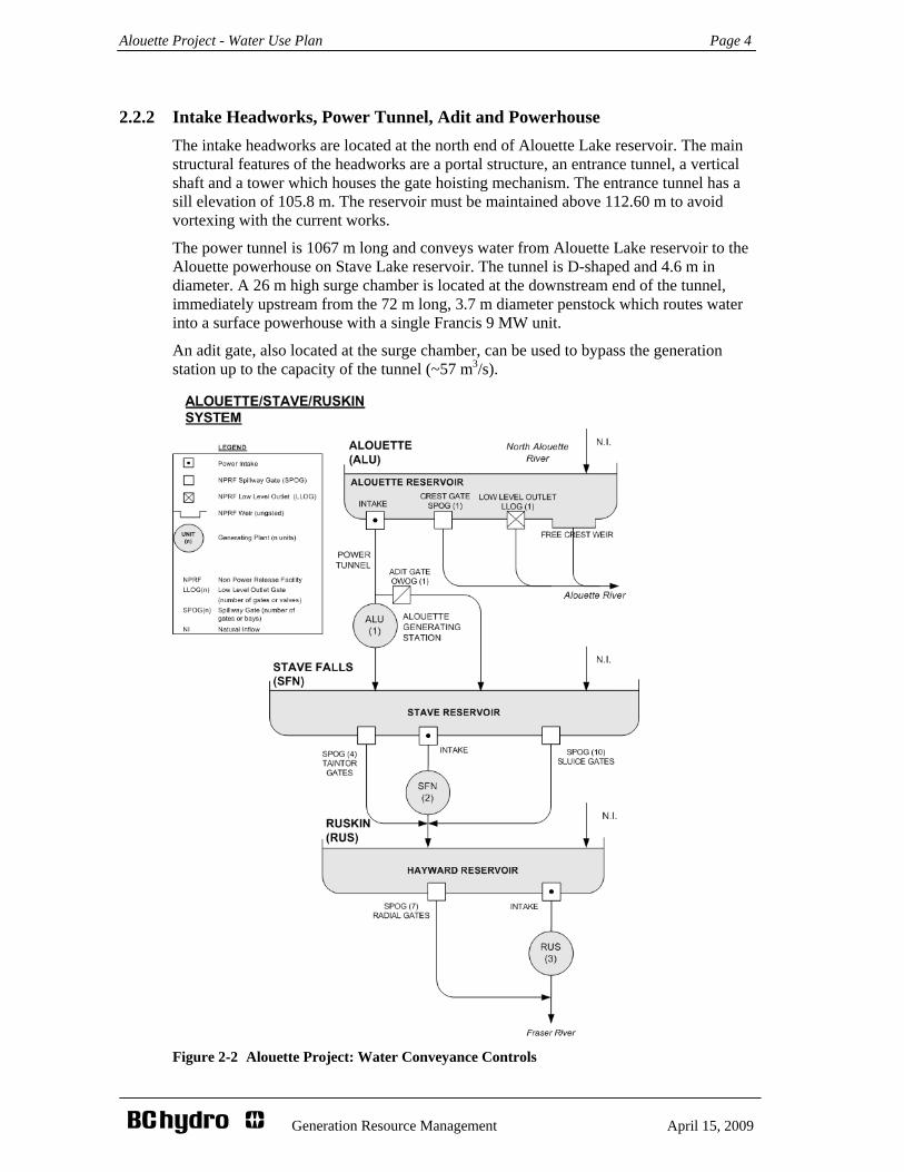
2.2.2 Intake Headworks, Power Tunnel, Adit and Powerhouse The intake headworks are located at the north end of Alouette Lake reservoir. The main structural features of the headworks are a portal structure, an entrance tunnel, a vertical shaft and a tower which houses the gate hoisting mechanism. The entrance tunnel has a sill elevation of 105.8 m. The reservoir must be maintained above 112.60 m to avoid vortexing with the current works.
The power tunnel is 1067 m long and conveys water from Alouette Lake reservoir to the Alouette powerhouse on Stave Lake reservoir. The tunnel is D-shaped and 4.6 m in diameter. A 26 m high surge chamber is located at the downstream end of the tunnel, immediately upstream from the 72 m long, 3.7 m diameter penstock which routes water into a surface powerhouse with a single Francis 9 MW unit.
An adit gate, also located at the surge chamber, can be used to bypass the generation station up to the capacity of the tunnel (~57 m3/s).
Figure 2-2 Alouette Project: Water Conveyance Controls

Alouette Project - Water Use Plan Page 5
Generation Resource Management April 15, 2009
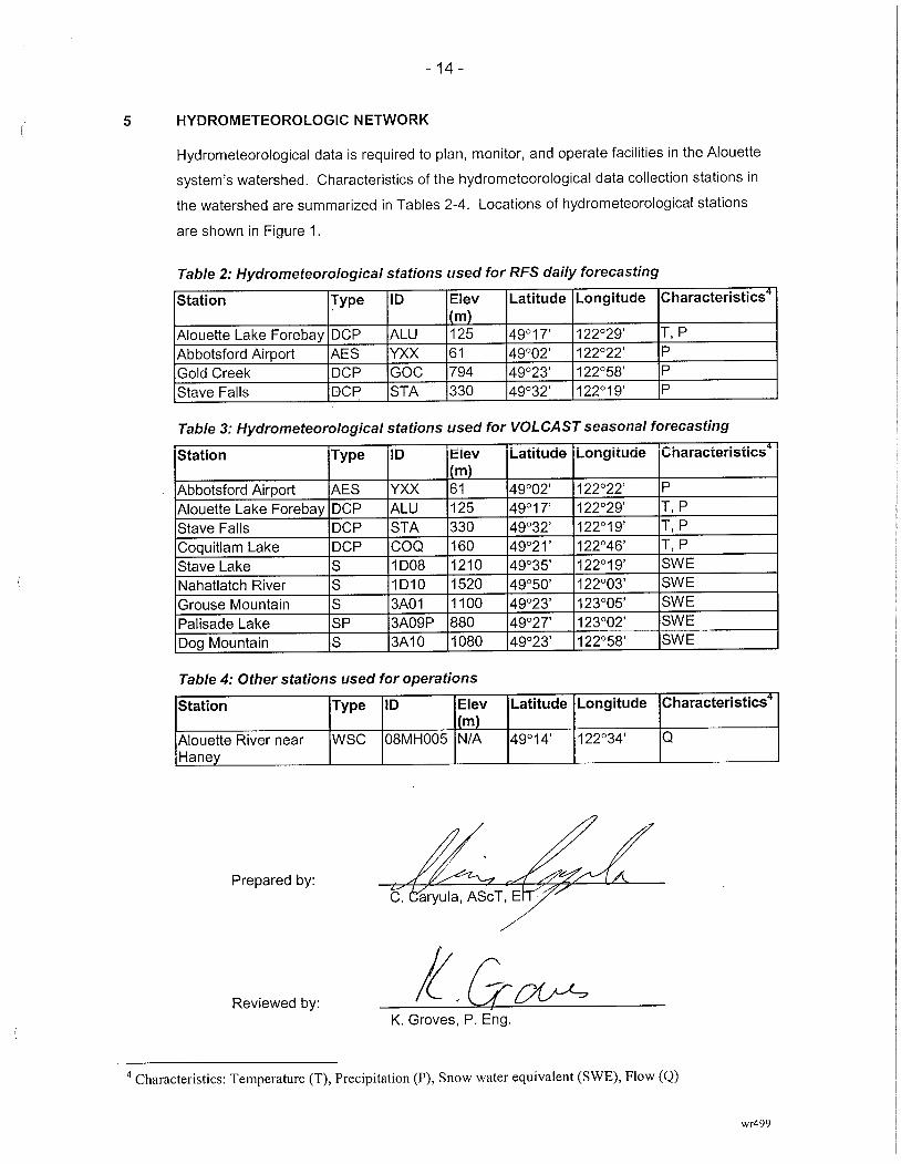
3.0 ALOUETTE RIVER HYDROLOGY The runoff regime of the Alouette watershed is characterised by moderate flows in the spring, April to June, resulting from snow melt. A recession period during the drier summer months is typically observed and followed by periods of frequent high inflow events from late October through March associated with seasonal storm events.
Table 3-1: Summary of Mean Annual Inflows (1960 to 2006).
PRJ LOCATION: MEAN ANNUAL INFLOW (MAI) MAI (m3/s)
ALU Alouette 21 SFN Stave 112 RUS Hayward 7
Appendix 1, the Alouette Water Use Plan Review: Hydrology of Alouette Lake Basin memo, describes in detail the physiography, climate, and hydrology of the Alouette Lake basin. The memo also describes daily inflow and seasonal volume inflow forecasting procedures. A description of the hydro-meteorological station network in the area and a summary of the inflow hydrographs for the Alouette Lake reservoir is also provided.
4.0 OPERATING CONDITIONS FOR FACILITIES
4.1 Role of Facility in BC Hydro’s System The Alouette generating facility is part of the Alouette, Stave Falls, and Ruskin hydroelectric power development that includes four dams, a diversion tunnel and three powerhouses. Water can be used from the Alouette Lake reservoir three times as it passes through each powerhouse to produce up to a total amount around 24 MW of electrical power. The power development as a whole can produce up to 205 MW and forms part of BC Hydro’s integrated generation system as described in BC Hydro’s publication, Making the Connection (2000).
The Alouette, Stave Falls, and Ruskin power development is located close to the Lower Mainland load centre. Its location is important for providing consistent voltage in the transmission network and for system security in the event of transmission or generation problems elsewhere in the system. The Alouette, Stave Falls, and Ruskin power development contributes about 2% of BC Hydro’s hydroelectric generation.
4.2 Water Use at Alouette Project The Alouette Lake reservoir is classified as a “coastal reservoir” where the majority of inflow results from seasonal storms and spring snowmelt.
Instantaneous diversion via the adit or generation from Alouette Lake reservoir to Stave Lake reservoir under Final Water Licences 124725 and 124724 is limited to 28.32 m3/s (1000 cfs) unless managing storage in Alouette for flood mitigation. Under FWL 124725 and 124724, maximum annual volume diversion is limited to 625.1 M·m3.
Alouette Project - Water Use Plan Page 6
Generation Resource Management April 15, 2009
Inflows that cannot immediately be used by the Alouette powerhouse can be stored in Alouette Lake reservoir between the licenced limits of 112.60 and 125.51 m (Final Water Licence 124726). Flood mitigation provisions under the 1996 and the 2009 Water Use Plans require active regulation of the storage using the adit and/or generation when reservoir elevation reaches 122.6 m or 124.70 m, depending on the time of year.
The Alouette generating station is normally operated as a base load facility, running relatively constant for weeks at a time. At full load, the unit typically generates 8 MW and discharges 23.8 m3/s (840 ft3/s) with the adit gate closed. Water routed through the adit can not be generated at Alouette Generation Station and reduces unit efficiency. At full load, the unit can generate only 5 MW with the adit gate open.
With the adit gate fully open and/or the unit at full load, total discharge to Stave Lake reservoir is limited to the power tunnel capacity of approximately 56.6 m3/s (2000 ft3/s). Water diverted from Alouette to Stave Lake reservoir in excess of what is authorized under FWL 124725 and 124724 is permitted via an order under the Water Act to meet flood mitigation objectives.
Under both the 1996 and the 2009 Water Use Plans, a minimum discharge for fish into Alouette River is provided via the low level outlet.
See section 4.4 for details on operations required under the 2009 Water Use Plan.
4.3 Emergencies and Dam Safety Emergencies and dam safety requirements shall take precedence over the operational constraints outlined in the Water Use Plan. Emergencies include, but are not limited to, actual or potential loss of power to customers, mechanical failures and environmental incidents. Dam safety requirements for operations are outlined in the Alouette Dam: Operation, Maintenance and Surveillance (OMS) Manual issued by BC Hydro’s Director of Dam Safety.
Operation instructions for surcharging the reservoir and undertaking drawdowns for dam safety are described in the OMS manual for Dam Safety. Community notification procedures are documented in the Alouette Dam Generation Emergency Plans.
4.4 Operation of Works for Diversion and Use of Water
BC Hydro proposes to operate the Alouette hydroelectric facility in accordance with the conditions outlined below. These conditions will replace operations previously governed by a Section 39 Order issued October 3, 1997 based on the September 25th, 1996 Alouette Water Use Plan.
During normal conditions the system is managed to maintain all components within the specified constraints. To meet the constraints, operating decisions require adjustments at a number of control points (Figure 2-2) and must consider both current conditions and the likelihood of being able to meet future constraints. BC Hydro may not be able to operate within these constraints during abnormal hydrological events.
Conflicts may arise between managing constraints during periods of normal or abnormal hydrological conditions or resulting from other events such as maintenance or unplanned outages. When conflicts arise the following, from highest priority to lowest, will guide operating decisions:

Alouette Project - Water Use Plan Page 7
Generation Resource Management April 15, 2009
Dam Safety requirements as defined in the Operation Maintenance and Surveillance Manuals for Alouette, Stave, and Ruskin Projects;
Flood routing and storage criteria defined in 4.4.3 and 4.4.4;
Flood routing criteria for the Stave and Ruskin systems;
Ramping rates;
Base flow provisions for fish; and
Recreation targets and other obligations.
4.4.1 Base flow release to Alouette River To enhance downstream fisheries habitat, a base flow release between 1.52 and 2.97 m3/s to the Alouette River will be provided through the low level outlet. The low level outlet must be set to its fully open position (2.97 m3/s at 125.51 m) at all times. If a base flow greater than 3.0 m3/s is being provided by either the crest gate or the free crest weir (e.g. during the spring surface release operation 4.4.2 or during spilling 4.4.4), the low level outlet may be closed.
4.4.2 Spring Surface Release
4.4.2.1 Base Spring Surface Release
The intent of the spring surface release (greater than 3 m3/s) is to provide a means for kokanee to leave the Alouette Lake reservoir and migrate seaward to potentially continue their life history as re-anadromised sockeye salmon.
From April 15 to June 14, the crest gate will be opened to target a surface release of at least 3.0 m3/s by maintaining a target reservoir level of about 121.85 m or greater. The low level outlet may be closed during this operation providing a base flow release greater than 3.0 m3/s is maintained at all times. The duration of the spring surface release can end sooner if monitoring data show that the kokanee out-migration period has ended.
The ability to deliver the spring surface release between April 15 and June 14 will be a function of initial reservoir storage level and subsequent inflows during this period. An initial reservoir elevation for April 15th shall be targeted to deliver the spring surface runoff flow 75% of the time based on historical inflows. If, during the release period, there is 25% likelihood or more of not meeting the 3 m3/s or greater flow target, a lesser revised target shall be determined in consultation with provincial and federal fisheries agencies and the Comptroller.
4.4.2.2 Pulse Spring Surface Release
During the spring surface release operation (April 15 to June 14) and at least seven days prior to the end of the release (June 7), discharge will be increased to between 6 and 9 m3/s for seven days in order to create a ‘freshet pulse’. The intent is to provide a migration cue to kokanee insensitive to the 3 m3/s spill. As with the 3 m3/s base spring surface release, the discharge will be attained through management of reservoir levels.

Alouette Project - Water Use Plan Page 8
Generation Resource Management April 15, 2009
Because of its dependency on prevailing inflow conditions, the pulse flow operation will be targeted opportunistically. The intent is to provide a ‘freshet pulse’ four out of every eight years to compare and contrast out-migration patterns with and without the pulse flow. If monitoring shows the pulse flow operation to be ineffective at providing additional out migration, a request to abandon the pulse flows may be made to the Comptroller of Water Rights prior to the next WUP review.
The ability to commence delivery of the pulse surface release between April 15 and June 7 will be a function of initial reservoir storage level and subsequent inflows during this period. If, during the release period, there is 50% likelihood or more of not meeting the 6-9 m3/s for seven days, a lesser revised target shall be determined in consultation with provincial and federal fisheries agencies and the Comptroller of Water Rights.
4.4.3 Power Tunnel Operations for Flood Mitigation To provide flood mitigation for Alouette River, it was recommended that the Alouette Lake reservoir retain the seasonal flood buffer limits introduced in the 1996 Water Use Plan. The buffer limits are:
i) 122.60 m during the high inflow period October 1 and March 31; and
ii) 124.70 m between April 1 and September 30.
The seasonal buffers are managed in part (see Section 4.4.4) by routing water from Alouette Lake reservoir to Stave Lake reservoir up to the licenced amount of 28.3 m3/s via the power tunnel through adit and/or generation diversion.
When inflows exceed 28.3 m3/s and the reservoir level is greater than the applicable buffer limit, the adit gate is used to divert up to an additional 28.3 m3/s for the purpose of flood mitigation.
Total diversion, regardless of whether it is generated and/or bypassed via the adit is limited by the capacity of the power tunnel, 56.6 m3/s. In the absence of exceeding the seasonal flood buffer limits, total diversion from Alouette Lake to Stave Lake reservoir by generation and/or the adit remains restricted to the licenced amount of 28.3 m3/s.
During high inflow events, meeting the aforementioned targets in 4.4.3 and 4.4.4 are subject to crew availability and site accessibility. It is expected, however, that changes to control devices be initiated within 24 hours to meet the discharge protocols.
4.4.4 Crest Gate Operation for Flood Control Alouette Lake reservoir free spills into the Alouette River via the free crest weir at elevations greater than 125.51 m.
In addition to the power tunnel (adit gate and generation), reservoir levels can be managed by the transition of spill discharge into Alouette River between the crest gate1 and the free crest weir2. Closing the crest gate while increasing free crest weir flows can reduce the peak discharge flow from the dam.
To manage discharge into Alouette River when the reservoir approaches or exceeds full pool, the following operations are recommended:
1 The “crest gate” is also referred to as the “gated spillway” or “SPOG”. 2 The “free crest weir” is also referred to as the “weir” or simply the “spillway”.
Alouette Project - Water Use Plan Page 9
Generation Resource Management April 15, 2009
i) When the reservoir is between 124.70 and 125.87 m, target a total discharge of 42.5 m3/s ±25% from the crest gate and the free crest weir by adjusting the crest gate.
ii) At reservoir levels greater than 125.87 m, the crest gate should be fully closed and reservoir levels are managed using the free crest weir (and adit operations under 4.4.3). As the reservoir level falls below 125.87 m, the crest gate is re-opened to maintain a total combined free crest weir and crest gate discharge of 42.5 m3/s ±25% as per i) above until the reservoir level falls below 124.70 m.
Changes to the adit gate or crest gate require crews to be on site. During high inflow events, meeting the aforementioned targets in 4.4.3 and 4.4.4 are subject to crew availability and site accessibility. Changes to the control devices are to be initiated within 24 hours in an attempt to meet the discharge protocols.
4.4.5 Flushing Flows The flushing flow regimes described in the 1996 Water Use Plan are no longer required. However, should monitoring find substrate quality to be deteriorating along with a coincident decline in chum egg to fry survival, a single 32 m3/s ± 10 % flush over a three day period may be delivered upon consultation with federal and provincial fisheries agencies and the Comptroller of Water Rights, providing that it does not increase the risk of downstream flooding and is feasible given prevailing hydrological conditions.
4.4.6 Ramping Rates Other than design constraints, there are no ramping restrictions for either the turbine or the adit gate for environmental or social interests.
i) For public safety considerations, ramping up the crest gate discharge into the Alouette River will not exceed 6.3 m3/s ± 15% every 40 minutes.
ii) To prevent fish stranding during crest gate closure, the ramp down rate will be such that the change in plunge pool stage elevation does not decrease by more than 5 cm every hour.
The ramp rates in i) and ii) above are in effect when making controlled changes to the crest gate or low level outlet, but not when free spilling over the free crest weir or when flows in the vicinity of the WSC Gauge 08MH005 on the Alouette River exceed 25 m3/s.
4.4.7 Turbine Operations Commencing mid September, the turbine is typically run at full load throughout the fall season to target a low reservoir level near 116 m. This is intended to manage inflows associated with fall and winter storms, providing ancillary benefits for flood mitigation and First Nation access to potential archaeological sites within the drawdown zone.
For the remainder of the year, turbine output, in conjunction with adit gate and crest gate operations will be managed as necessary to meet seasonal elevations requirements.
4.5 Operation of Storage Works The following constraints apply to the operation of storage works for Alouette Dam. It is recognized that BC Hydro may not be able to operate within these constraints during the event of an emergency, a dam safety requirement or an extreme hydrological event.
Alouette Project - Water Use Plan Page 10
Generation Resource Management April 15, 2009
4.5.1 Spring Surface Release As noted in 4.4.2, a spring surface release to manage the outmigration of kokanee from the reservoir is to be implemented between April 15 and June 14. A target reservoir level of about 121.85 m or greater will be maintained in order to provide sufficient head for the release of at least 3.0 m3/s from the Alouette Dam crest gate.
The targeted reservoir elevation will also provide increased recreational benefits during the spring recreation shoulder season (April 15 to May 14), as well as the early part of the peak recreation season (May 15 to June 14).
4.5.2 Recreation Season Targets on Alouette Lake Reservoir The reservoir will be operated at or above the following elevations to improve reservoir recreation objectives:
• From June 15 to July 15 the reservoir will be operated at or above an elevation of 122.0 m;
• From July 16 to September 5 the reservoir will be operated at or above an elevation of 122.5 m; and
• From September 6 to September 15 the reservoir will be operated at or above an elevation of 121.25 m.
The targeted reservoir elevations will also provide protection for First Nations archaeological sites during period of high recreational use in the reservoir, as well as help promote boating access and safety.
The ability to manage the reservoir levels between June 15 and Sept 15 will be a function of initial reservoir storage level and subsequent inflows during this period. An initial reservoir elevation of 122.5 m for June 15th shall be targeted after June 15th to meet the objective 75% of the time based on historical inflows. If, during the period, there is 25% likelihood or more of not meeting the reservoir targets, a lesser revised target shall be determined in consultation with the Comptroller of Water Rights.
In case of conflict between recreational targets on Alouette Lake reservoir and flow management for fish interests downstream of the Alouette Dam or the Ruskin Dam, the flow management requirements for fish shall take precedence (see section 4.4).
5.0 PROGRAM FOR ADDITIONAL INFORMATION Development of an optimal operating strategy for the Alouette River system was complicated by some uncertainties and information gaps. The August 2006 consensus agreement of the Consultative Committee was contingent on the implementation of the following monitoring programs to reduce these uncertainties over time.
It is recommended that the Comptroller of Water Rights direct BC Hydro to undertake a monitoring program that will:
• Evaluate the effectiveness of the new operating constraints; and
• Provide improved information on which to base future operating decisions.
Details and costs of the proposed monitoring program are provided in the 2006 Alouette Dam Water Use Plan: Consultative Committee Report.

Alouette Project - Water Use Plan Page 11
Generation Resource Management April 15, 2009
The requirements are designed to address key questions that affected decisions throughout the consultation process. These questions are summarized in Table 5.1.
Table 5-1 Recommended Monitoring Programs and Related Objectives
Monitoring Study Objectives 1. Smolt Enumeration
Study
1. Following their migration out of Alouette Lake reservoir, do the kokanee immediately continue their migration out of the Alouette River or do they delay their seaward migration for a period of time?
2. Using adult chum salmon counts at the Alco Park Hatchery as an indicator of run strength and the results of the substrate quality monitor, is there evidence of a persistent, declining trend in egg to smolt survival that would suggest a degrading condition in spawning substrate quality.
3. Does the average base-flow release from the Alouette Dam continue to be adequate to sustain current levels or further improve salmonid smolt production downstream of the dam? Species of interest include pink, chinook, and coho salmon as well as steelhead and cutthroat trout.
4. Does total annual smolt production vary in relation to warmer water temperature, indicating a shift in community structure?
2. Kokanee Out-Migration Study
1. Is the surface release of at least 3 m3/s from the Alouette Dam (obtained through the crest gate) adequate to promote the downstream migration of kokanee out of the Alouette Lake reservoir?
2. Does a post-surface release flush of 6-9 m3/s, lasting 7 days following the tail end of the out migration period, encourage more kokanee to leave the system?
3. How long should the surface release last to ensure out migration of all kokanee prepared to leave the system?
3. Substrate Quality Study
1. Do the results of the Toe-Pebble count procedure reflect the general composition of bed materials within the channel downstream of the Alouette Dam?
2. Is the < 20% fines threshold adequate to distinguish a state in substrate quality that would require a prescribed flushing event?
3. Is an alternative methodology required to qualify/calibrate the results of the Toe-Pebble count procedure?
4. For each year of the monitor, is a prescribed flushing flow necessary given the current state of substrate quality?
4. Sockeye Adult Enumeration Study
1. Are the Alouette Lake reservoir kokanee successfully adapting to an anadromous existence by returning from the ocean environment to spawn in Alouette Lake reservoir?
2. What is the run timing of adult sockeye returns? 3. Are the adult sockeye caught during the monitor members of the ‘Alouette stock’
or are they strays from other coastal systems? 4. Are the returning adult sockeye numbers sufficient to create a self sustaining
population given the existence of the Alouette Lake reservoir Fertilization Program, and whatever strategy is used to get the returning adults back into the reservoir?

Alouette Project - Water Use Plan Page 12
Generation Resource Management April 15, 2009
Table 5-1…continued. 5. Water Temperature
Study 1. How often are water temperatures ≥ 25°C, the incipient lethal temperature of
most stream rearing salmonid species, including the duration of each event and the frequency of occurrence?
2. Is the duration of observed warm water events less than 1 day, thus limiting exposure to warm waters and therefore thermal stress impacts?
3. Are warm temperature events restricted to certain sections of river, indicating the inflow of cooler waters into system (most likely ground water)?
4. Is the duration and frequency of warm water events such that it would promote a shift in fish community structure and/or reduce summer survival and growth of rearing juvenile salmonids, as indicated by a change in salmonid smolt numbers?
5. Given the extent of thermal stratification in the reservoir and the location of the low level outlet, is there an operational change that can be implemented to mitigate the occurrence of warm water events?
6. Kokanee Age Structure Study
1. Is the existing kokanee population in the Alouette Lake reservoir recruitment limited?
2. If there is evidence of a recruitment constraint to productivity, can it be linked to reservoir operations, particularly the extent of reservoir fluctuation during the spawning and incubation period (deemed to be mid-October to the end of February)?
3. If found linked to reservoir operation, what is the nature of the relationship and can it guide the development of possible mitigative reservoir operations?
7. Archaeological Impact Assessment Reservoir
1. Where are the archaeological sites in the reservoir? 2. What are the relative heritage values of identified sites? 3. What is the nature and extent of the impacts to archaeological sites that are
caused by reservoir operations? 8. Archaeological
Impact Assessment River
1. Are there archaeological resources that are impacted by river flows? 2. Would an operational change potentially lessen those impacts?
6.0 IMPLEMENTATION OF RECOMMENDATIONS The proposed conditions for the operation of BC Hydro’s Alouette Project facilities and monitoring program proposed in the 2009 Alouette Project Water Use Plan will not come into effect until after BC Hydro receives direction from the Comptroller of Water and implemented under the British Columbia Water Act.
7.0 EXPECTED WATER MANAGEMENT IMPLICATIONS
7.1 Other Licensed Uses of Water The proposed conditions in the 2009 Water Use Plan are not expected to affect other current licensed users of water associated with Alouette Lake reservoir or Alouette River below Alouette Dam.
7.2 Riparian Rights The proposed conditions in the 2009 Water Use Plan are not expected to affect riparian rights associated with Alouette Lake reservoir or Alouette River below Alouette Dam.

Alouette Project - Water Use Plan Page 13
Generation Resource Management April 15, 2009
7.3 Fish Habitat The proposed conditions in the 2009 Water Use Plan are expected to maintain and improve fish habitat conditions in Alouette River below Alouette Dam. Higher reservoir elevations in Alouette Lake reservoir during spring and summer will slightly increase low level outlet releases in the period, possibly increasing habitat and improving water quality. Though the use of prescribed flushing flow regimes has been abandoned, current substrate quality will likely be maintained as a result of normal spillway gate operations and opportunistic flushing spills.
The proposed conditions in the 2009 Water Use Plan are not expected to affect fish productivity in Alouette Lake reservoir. The use of a spring surface release regime, however, is expected to encourage the out-migration of kokanee to further the re-introduction of sockeye salmon to the Alouette River system.
7.4 Wildlife Habitat The proposed conditions in the 2009 Water Use Plan are not expected to significantly affect wildlife habitat associated with Alouette Lake reservoir or Alouette River below Alouette Dam. Though a total of 8 wildlife species of concern were identified in the area, the potential for adverse habitat impact was considered to be very low to non-existent. Anecdotal information gained through the monitoring program suggests that wildlife use in the area has increased dramatically since implementation of the September 1996 Water Use Plan.
7.5 Flood Mitigation The proposed conditions in the 2009 Water Use Plan are expected to maintain current levels of flood mitigation in Alouette River below Alouette Dam. The flood management triggers and communication protocols established during implementation of the September 1996 Water Use Plan have proven effective and did not warrant any changes other than clarification. Organizational changes to the communications protocols have occurred to better align them with the District of Maple Ridge roles and responsibilities.
7.6 Recreation The proposed conditions in the 2009 Water Use Plan are expected to increase recreational opportunities in Alouette Lake reservoir with the longer duration of summer target reservoir elevations greater than 122.0m. Fishing, beach access and boating safety are also expected to improve. No changes to downstream recreation are expected below Alouette River.
7.7 Water Quality The proposed conditions in the 2009 Water Use Plan are not expected to significantly affect current water quality associated with Alouette Lake reservoir or Alouette River below Alouette Dam. The higher reservoir elevation expected during the spring and summer months may lead to a slightly greater discharge out of the low level outlet, and hence increase flushing/dilution of point sources of downstream pollution.

Alouette Project - Water Use Plan Page 14
Generation Resource Management April 15, 2009
7.8 Industrial Use of Water The proposed conditions in the 2009 Water Use Plan are not expected to affect current industrial use of water associated with Alouette Lake reservoir or Alouette River below Alouette Dam.
7.9 First Nations Considerations The Alouette River system lies within the traditional territory claimed by the Katzie and Kwantlen First Nations. The Kwantlen First Nation chose to maintain observer status in the Alouette WUP Review Process. The Katzie First Nation has expressed an interest in:
• Understanding how their ancestors lived;
• Protecting archaeological sites from erosion and illegal collection of artifacts;
• Assessing sites for mitigation and inventory purposes, as well as cultural and spiritual activities;
• Recovering and interpreting artifacts; and
• Promoting the ecological integrity and functionality of the watershed.
7.10 Archaeological Considerations The operation of the storage works described in section 4.0 will allow Katzie an opportunity to conduct archaeological inventories, recover artifacts, assess the condition of sites and mitigate potential damage caused by operations within the normal drawdown zone. It will also allow them to conduct on-site cultural or spiritual activities.
The Water Use Plan is expected to improve protection of archaeological sites from public disturbance, illegal artifact collection and damage from use of recreational vehicles because of higher target reservoir levels during the peak recreation season. Also, monitoring programs associated with the Water Use Plan are expected to increase understanding of archaeological resources and First Nations history in the area.
BC Hydro will work with First Nations as required under British Columbia’s Heritage Conservation Act.
7.11 Power Generation The proposed conditions in the 2009 Water Use Plan are not expected to significantly affect power generation either at the Alouette powerhouse. There is a minor reduction in power generation associated with the Alouette, Stave Falls, and Ruskin power development as a whole relative to operations under the 1997 interim Order.
8.0 RECORDS AND REPORTS
8.1 Compliance Reporting BC Hydro will submit data as required to the Comptroller of Water Rights, to demonstrate compliance with the conditions conveyed in the Water Licenses or Order. The submission will include records of:
• Alouette Lake reservoir elevations;

Alouette Project - Water Use Plan Page 15
Generation Resource Management April 15, 2009
• Flow release from low level outlet, crest gate, free crest weir; • Plunge pool stage elevation during crest gate operations; • Total discharge into Alouette River; • Generation discharge from Alouette Generation Station; • Diversion flows through the adit; and • Annual cumulative volume diverted from Alouette Lake reservoir to Stave Lake
reservoir associated with Final Water Licences 124724 and 124725 through the adit and/or generation, and total annual cumulative volume diverted through the adit.
8.2 Non-compliance Reporting Non-compliance with operating conditions required by the water licenses or Water Act order, or anticipation thereof, will be reported to the Comptroller of Water Rights in a timely manner.
8.3 Monitoring Program Reporting Reporting procedures will be determined as part of the detailed terms of reference for each monitoring study or undertaking.
9.0 PLAN REVIEW The Consultative Committee recommended that a Monitoring Advisory Committee be created from a subset of representatives from the Consultative Committee and that BC Hydro meet annually with the Advisory Committee to review compliance with operations and discuss the results of the monitoring programs.
A full review of the 2009 Alouette Water Use Plan is recommended to coincide with the Stave Water Use Plan review. The reviews will be merged into a single Water Use Plan that better reflects the integrated nature of the Alouette, Stave Falls, and Ruskin hydroelectric power developments. The Stave/Ruskin Water Use Plan is currently scheduled for review commencing May 2014.
A review of the Alouette Project Water Use Plan could be triggered sooner if significant risks are identified that could result in a recommendation to change operations.
10.0 NOTIFICATION PROCEDURES Notification procedures for floods and other emergency events are outlined in the Generation Emergency Plan for Lower Mainland Generation. This document is filed with the Office of the Comptroller of Water Rights.

Alouette Project - Water Use Plan
Generation Resource Management April 15, 2009
Appendix 1
Alouette Project Water Use Plan Hydrology Memo
wr499
Inter-office memo
TO: Paul Vassilev 3 November, 2005
FROM: Chris Caryula File: REGWUP ALC200
SUBJECT: Alouette Water Use Plan Review Hydrology of Alouette Lake Basin
1 INTRODUCTION
The Alouette project is most upstream in a 3 reservoir hydroelectric project with the following
general characteristics:
Alouette Dam impounds Alouette Lake Reservoir.
Spill and other non-power releases from the Alouette Dam discharge into the Alouette
River.
Power releases from Alouette Reservoir (turbine discharge) are diverted through a 4.6 m
diameter and 1067 m long tunnel to the Alouette Powerhouse (one unit, typical maximum
output ~ 9 MW) located on Stave Lake Reservoir.
Non-power releases from the diversion tunnel are discharged through an Adit Gate to
Stave Lake Reservoir.
Discharge from the Alouette Powerhouse enters Stave Lake Reservoir.
This report highlights the hydrology of the Alouette hydroelectric system. Physiography and
climatology are reviewed for the Alouette Lake watershed.
Methods used to calculate reservoir inflows, such as BC Hydro’s FLOCAL program, are discussed.
Typical inflow hydrographs and summaries are provided. Flow records for the Alouette system
referred to in this report were used in power studies conducted for the Alouette Water Use Plan
Review.
Procedures used to provide daily and seasonal inflow forecasts are also described.

- 2 -
wr499
2 BASIN DESCRIPTION
2.1 Physiography1
The Alouette drainage basin is adjacent
to the western boundary of the Stave
watershed as shown in Figure 1.
Alouette has a drainage area of 202 km2
that ranges in elevation from 120 m to
1800 m. The median basin elevation is
650 m as indicated in the hypsometric
curve shown in Figure 2. The curve
defines the percentage of the watershed
above or below a given elevation.
Figure 2: Hypsometric curve for the Alouette River Watershed
1 Basin information obtained from BC Hydro “Stave Falls Project: Probable Maximum Flood”, BC Hydro Hydroelectric Generation Projects Division, Report No. H1588, September 1983
Hypsometric curve for Alouette River watershed above Alouette Dam
0
200
400
600
800
1000
1200
1400
1600
1800
2000
0 10 20 30 40 50 60 70 80 90 100
Percent of Watershed Area Below (%)
Elev
atio
n (m
)
From BCH Report no. H1576 (1983)
- 3 -
wr499
Flows from Alouette Lake Reservoir are either diverted through a diversion tunnel to a
power plant located on Stave Lake Reservoir, or are allowed to spill past Alouette Dam
down the Alouette River. Approximately 94 % of annual inflow to Alouette Lake Reservoir
is diverted through the diversion tunnel to Stave Lake Reservoir, based on 1984 to 2000
data.
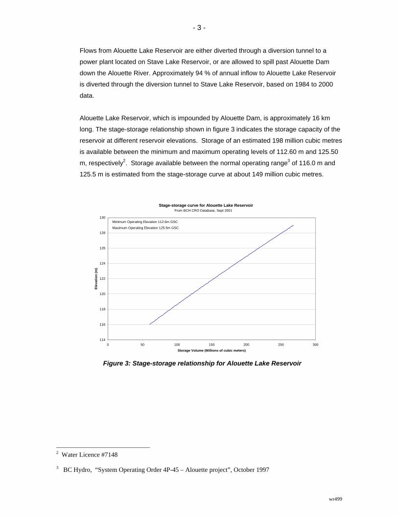
Alouette Lake Reservoir, which is impounded by Alouette Dam, is approximately 16 km
long. The stage-storage relationship shown in figure 3 indicates the storage capacity of the
reservoir at different reservoir elevations. Storage of an estimated 198 million cubic metres
is available between the minimum and maximum operating levels of 112.60 m and 125.50
m, respectively2. Storage available between the normal operating range3 of 116.0 m and
125.5 m is estimated from the stage-storage curve at about 149 million cubic metres.
Figure 3: Stage-storage relationship for Alouette Lake Reservoir
2 Water Licence #7148 3 BC Hydro, “System Operating Order 4P-45 – Alouette project”, October 1997
Stage-storage curve for Alouette Lake Reservoir
114
116
118
120
122
124
126
128
130
0 50 100 150 200 250 300
Storage Volume (Millions of cubic meters)
Elev
atio
n (m
)
From BCH CRO Database, Sept 2001
Minimum Operating Elevation 112.6m GSC
Maximum Operating Elevation 125.5m GSC
- 4 -
wr499
2.2 Climatology The major source of precipitation in the Alouette Lake Reservoir drainage basin during the
fall and winter months comes from frontal southwesterly flows of warm moist air aloft. The
abrupt rise of the Coast Mountains above the flat or rolling topography of the Lower Fraser
Valley has a significant influence on this moist air. Strong orographic lifting provides the
primary mechanism whereby moisture aloft is converted to basin precipitation.
In contrast, sources of precipitation in the summer are generally from weak frontal or
convective storms. About one third of the annual precipitation occurs from these weak
weather systems during the six-month warm period from April through September.
Summer frontal or convective storms strong enough to initiate heavy rainfall in the order of
100 mm in a 24-hour period occur relatively infrequently.
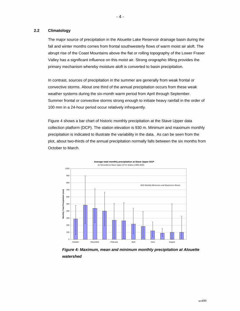
Figure 4 shows a bar chart of historic monthly precipitation at the Stave Upper data
collection platform (DCP). The station elevation is 930 m. Minimum and maximum monthly
precipitation is indicated to illustrate the variability in the data. As can be seen from the
plot, about two-thirds of the annual precipitation normally falls between the six months from
October to March.
Figure 4: Maximum, mean and minimum monthly precipitation at Alouette
watershed
Average total monthly precipitation at Stave Upper DCP
0
100
200
300
400
500
600
700
800
900
1000
October December February April June August
Mon
thly
Tot
al P
reci
pita
tion
(mm
)
As Recorded at Stave Upper (STV) Station (1986-2000)
With Monthly Minimums and Maximums Shown
- 5 -
wr499
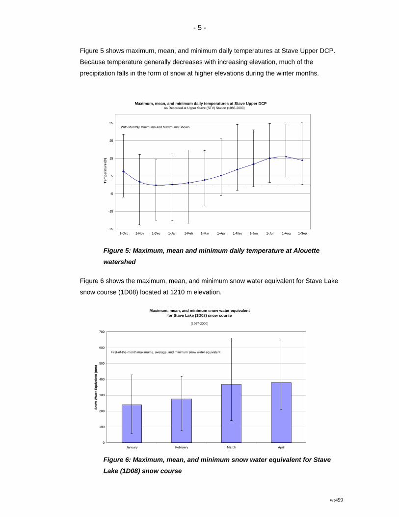
Figure 5 shows maximum, mean, and minimum daily temperatures at Stave Upper DCP.
Because temperature generally decreases with increasing elevation, much of the
precipitation falls in the form of snow at higher elevations during the winter months.
Figure 5: Maximum, mean and minimum daily temperature at Alouette watershed
Figure 6 shows the maximum, mean, and minimum snow water equivalent for Stave Lake
snow course (1D08) located at 1210 m elevation.
Figure 6: Maximum, mean, and minimum snow water equivalent for Stave Lake (1D08) snow course
Maximum, mean, and minimum daily temperatures at Stave Upper DCP
-25
-15
-5
5
15
25
35
1-Oct 1-Nov 1-Dec 1-Jan 1-Feb 1-Mar 1-Apr 1-May 1-Jun 1-Jul 1-Aug 1-Sep
Tem
pera
ture
(C)
As Recorded at Upper Stave (STV) Station (1986-2000)
With Monthly Minimums and Maximums Shown
Maximum, mean, and minimum snow water equivalent for Stave Lake (1D08) snow course
0
100
200
300
400
500
600
700
January February March April
Snow
Wat
er E
quiv
alen
t (m
m)
(1967-2000)
First-of-the-month maximums, average, and minimum snow water equivalent

- 6 -
wr499
3 RESERVOIR INFLOWS
3.1 Inflow calculations
Reservoir inflow calculations: Inflow is the volume of water entering a reservoir within a
given period of time. Reservoir inflows are calculated rather than measured directly. Daily
inflows may be derived from mean daily discharge from the reservoir and change in
reservoir storage over a period of 24 hours. The generic formula is:
INFLOW = OUTFLOW + Δ STORAGE......................................(1)
where INFLOW = average inflow over a one - day period
OUTFLOW = average outflow over a one - day period
Δ STORAGE = S2 - S1, where
S2 = reservoir storage at the end of the day
S1 = reservoir storage at the end of the previous day
Reservoir storage for a specific reservoir elevation is derived from a stage – storage curve
unique to each reservoir.
The nature of the calculation of inflows can result in “noisier” hydrographs than observed at
unregulated, natural river channels. Noisy inflows can arise due to various sources of
error, such as wind set up on the reservoir, resolution of elevation measurements, errors in
reservoir elevation readings, errors in outflow measurements through turbines, spillways or
valves, errors in stage-storage curves and errors in the rating curves for various outlet
facilities. The impact of noise tends to reduce as the time interval over which inflow is
computed increases.
Storage relationships: The Storage relationships used to determine the volume of water in Alouette
Lake Reservoir is shown in Figure 3.
Outflow relationships: Flow through turbines at the Alouette powerhouse is computed based on
megawatt output and hydraulic head. “Hydraulic head” is a measure of the vertical
distance between the water level in the reservoir and the water level immediately below the
turbine outlet. Power output is proportional to head and turbine discharge. A generic
relationship between these variables is shown in Figure 7.

- 7 -
wr499
G e n e r ic re la t io n s h ip b e tw e e n f lo w , g e n e ra t io n a n d h e a d fo r a tu rb in e
In c re a s in g G e n e ra t io n
Incr
easi
ng F
low
In c re a s in g H e a d
Figure 7: Generic relationship between flow, generation, and head for a turbine
“Rating curves” show the relationship between flow, opening, and elevation for a given
release device. A rating curve for spill facilities at Alouette Dam is shown in Figure 8.
Figure 8: Rating curve for Alouette Dam
Data records: BC Hydro computes inflow using a computer program called FLOCAL.
Specifically;
Inflows to Alouette Lake Reservoir are computed based on equation (1).
Gated Spillway + Free Crest Spillway Rating Curve for Alouette Dam
121
122
123
124
125
126
127
128
129
130
0 200 400 600 800 1000 1200 1400Discharge (cms)
Res
ervo
ir El
evat
ion
(m)
From Alouette Plant Data Book (April 1999)
Minimum Normal Operating Level 112.6m
Maximum Normal Operating Level 125.5m
- 8 -
wr499
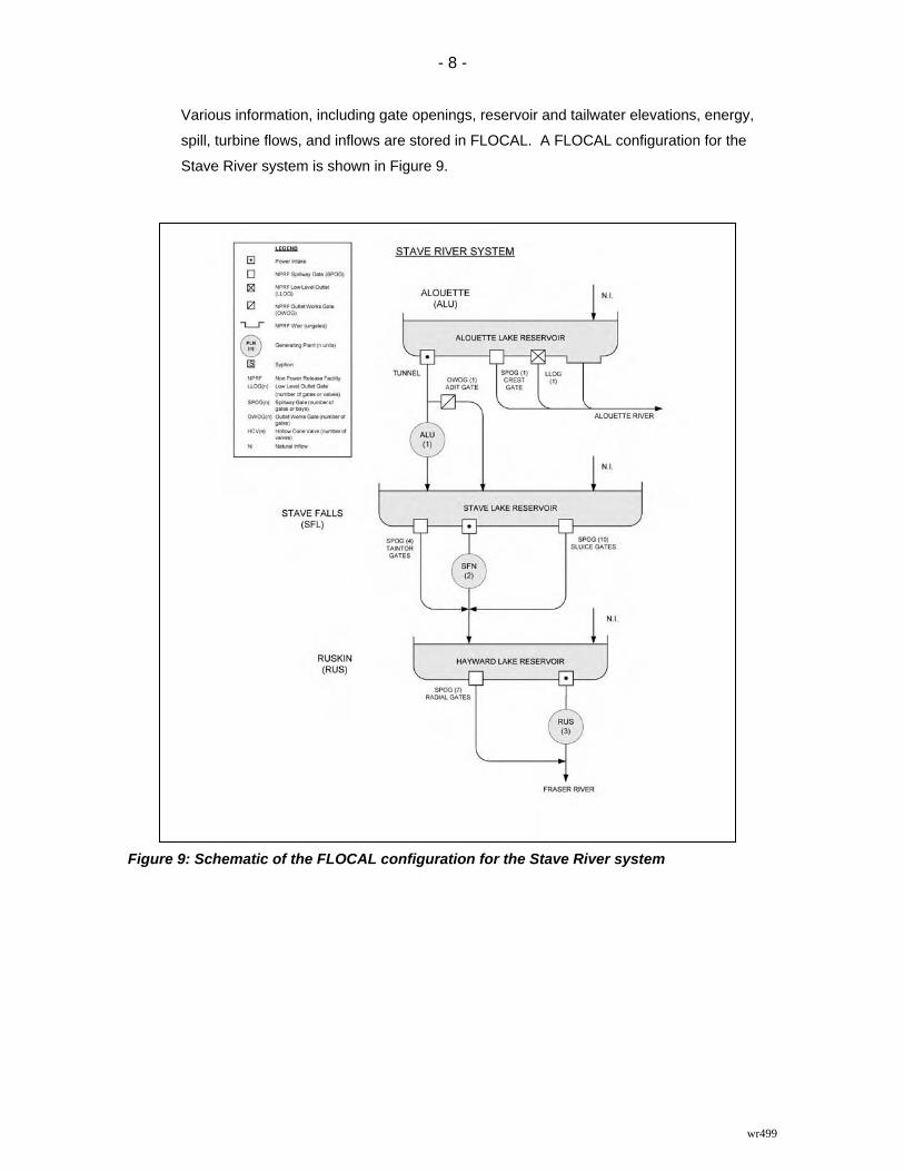
Various information, including gate openings, reservoir and tailwater elevations, energy,
spill, turbine flows, and inflows are stored in FLOCAL. A FLOCAL configuration for the
Stave River system is shown in Figure 9.
Figure 9: Schematic of the FLOCAL configuration for the Stave River system

- 9 -
wr499
3.2 Reservoir inflow characteristics
Figure 10 shows “spaghetti plots” of historical inflows to the Alouette project. The 10th, 50th
and 90th percentile inflows are shown in bold.
Figure 10: Historical Daily Inflows to Alouette Lake Reservoir
Figure 11 and Table 1 summarizes the daily inflows by month. Average monthly and
maximum and minimum daily inflows are shown to highlight the variability of inflows to the
project.
Figure 11: Variability in Alouette Project’s daily inflows
Daily Inflow Hydrographs for Alouette Lake ReservoirBased on BC Hydro Data (1960-2004)
050
100150200250300350400450500
Jan Mar May Jul Sep Nov
Dai
ly In
flow
(cm
s)
Daily Inflow90th Percentile Inflow50th Percentile Inflow10th Percentile Inflow
Mean, Maximum and Minimum Daily Inflowsto Alouette Lake Reservoir (1960-2004)
050
100150200250300350400450500
October December February April June August
Dai
ly In
flow
(cm
s)

- 10 -
wr499
Table 1: Alouette Project’s daily inflows (1960-2004)
Month Mean Maximum MinimumOctober 11 218 0.40November 6 206 0.01December 9 189 0.06January 23 360 0.06February 35 452 0.08March 32 378 0.06April 30 397 0.15May 24 351 0.12June 22 379 0.17July 22 221 0.17August 23 156 0.17September 19 126 0.96

- 11 -
wr499
A “flow duration curve” indicates the percent of time that a flow is greater than a given
discharge. Figure 12 shows a flow duration curve of daily inflows for the years 1960-2004;
it illustrates the large range and variability of inflows.
Figure 12: Duration curves of daily inflows to Alouette Lake Reservoir
Figure 13 shows a duration curve for annual inflow volume.
Figure 13: Duration curve of annual volume to Alouette Lake Reservoir
Duration Curve of Annual Inflow Volume to Alouette Lake Reservoir
0
2000
4000
6000
8000
10000
12000
0 10 20 30 40 50 60 70 80 90 100Time That Annual Inflow Volume is Greater Than Shown (%)
Ann
ual I
nflo
w V
olum
e (c
ms-
d)
Duration Curve of Daily Inflows to Alouette Lake Reservoir
0100
200300400500
600700
0 10 20 30 40 50 60 70 80 90 100
Time That Inflow is Greater Than Shown (%)
Dai
ly In
flow
(cm
s)

- 12 -
wr499
Figure 14 shows a comparison between the mean annual local inflow and total live storage
available at a number of project reservoirs.
Figure 14: Comparison of project annual inflows to reservoir storage throughout BC
Hydro’s system
Notes Each graph has it's own scale Inflows are based on 1961-1990 normals Ability to route flows through a reservoir also depends on turbine and gate discharge capabilities Total storage may not always be available due to reservoir operating constaints. All numbers expressed in millions of cubic meters
Lower Mainland
Bridge
Coastal
Vancouver Island
Interior
Kootenay
Columbia
Peace
Comparison of project annual local inflow to reservoir storage
throughout BC Hydro's system
0
10000
20000
30000
40000
Wahleach
0
100
200
300
400
Inflow Storage
Duncan
0
1000
2000
3000
4000
Inflo
w
Sto
rage
Jordan Div
0
100
200
300
400
Inflo
w
Sto
rage
Alouette
0
200
400
600
800
Inflow Storage
Ash
0
200
400
600
800
Inflo
w
Sto
rage
Coquitlam
0
200
400
600
800
Inflow Storage
Comox
0
300
600
900
1200
Inflo
w
Sto
rage
Clowhom
0
300
600
900
1200
Inflo
w
Sto
rage
Lajoie
0
400
800
1200
1600
Inflo
w
Sto
rage
Sugar
0
400
800
1200
1600
Inflo
w
Sto
rage
Daisy
0
500
1000
1500
2000
Inflo
w
Sto
rage
Strathcona
0
1000
2000
3000
4000
Inflo
w
Sto
rage
Carpenter
0
500
1000
1500
2000
Inflo
w
Sto
rage
Corra Linn
0
4000
8000
12000
16000
Inflo
w
Sto
rage
Stave
0
1000
2000
3000
4000
Inflow Storage
Whatshan
0
100
200
300
400
Inflo
w
Sto
rage
Mica
0
5000
10000
15000
20000
Inflo
w
Sto
rage
Williston
0
10000
20000
30000
40000
Inflo
w
Sto
rage
Arrow
0
3000
6000
9000
12000
Inflo
w
Sto
rage
0
500
1000
1500
2000
Alo
uette
Coq
uitla
m
Sta
ve
Wah
leac
h
Lajo
ie
Car
pent
er
Dai
sy
Clo
who
m
Stra
thco
na
Com
ox
Ash
Jord
an D
iv
Sug
ar
Dun
can
Cor
ra L
inn
Wha
tsha
n
Mic
a
Rev
elst
oke
Arr
ow
Willi
ston
Small scale
Large scale
Revelstoke
0
2000
4000
6000
8000
Inflo
w
Sto
rage
Live Storage (MCM)
Live Storage (MCM)
Seton
0
250
500
750
1000
Inflo
w
Sto
rage
- 13 -
wr499
4 OPERATIONAL INFLOW FORECASTING
BC Hydro’s Resource Management produces two main types of hydrologic forecasts: daily
and seasonal inflow forecasts for the Alouette project.
Daily inflow forecasts: Inflow forecasts are short-term forecasts that indicate the inflow
expected over the next few hours or days. These forecasts are used to plan hydroelectric
power scheduling and flood control, for optimum use of available water resources.
Each morning of each working day, the forecast team forecasts the daily inflow for the next
five days. The River Forecast System (RFS) software produces these forecasts using the
UBC watershed model. For a given watershed, the model simulates basin state conditions,
such as the snowpack, groundwater, and soil moisture. Then using forecasts of daily
precipitation, and minimum and maximum temperatures over the next five days, the model
simulates the various components of the runoff, which include rainfall and snowmelt runoff,
glacier melt, and baseflow. Together, these components represent the expected inflow
hydrograph for the reservoir.
Seasonal inflow forecasts: Seasonal inflow forecasts estimate the volume of water that is
expected to flow into the Alouette system during a given period. BC Hydro typically
produces forecasts for the period February through September. The forecasts are updated
on the first of each month from January 1 to August 1.The ability to forecast seasonal
runoff for this period lies in the fact that a significant portion of the runoff during the forecast
period is the product of snowmelt runoff. By measuring snow water equivalent in the
mountain snowpack, as well as other parameters such as precipitation and streamflow up
to the forecast date, a more accurate estimate of future runoff can be made than one
based on historical inflow data alone. To produce Alouette water supply forecasts, BC
Hydro uses a regression-based statistical Volume Forecast model (VOLCAST), which is
currently updated to the Volume Distribution and Calculation model (VoDCA). With the
increased usage of computer-based watershed models, such as the UBC Watershed
Model, a second method of forecasting runoff volume is available.