Review of Ordinary High Water Mark Indicators for ... · Indicators for Delineating Arid Streams in...
138
Review of Ordinary High Water Mark Indicators for Delineating Arid Streams in the Southwestern United States Edited by Robert W. Lichvar and James S. Wakeley January 2004 Approved for public release; distribution is unlimited. ERDC TR-04-1 Engineer Research and Development Center US Army Corps of Engineers® Engineer Research and Development Center
Transcript of Review of Ordinary High Water Mark Indicators for ... · Indicators for Delineating Arid Streams in...

Review of Ordinary High Water MarkIndicators for Delineating Arid Streamsin the Southwestern United States
Edited by Robert W. Lichvar and James S. Wakeley January 2004
Approved for public release; distribution is unlimited.
E
RD
C T
R-0
4-1
En
gin
eer
Researc
h a
nd
De
velo
pm
en
t C
en
ter
US Army Corpsof Engineers®
Engineer Research andDevelopment Center

Front cover: Oblique aerial photograph of Mission Creek, east of Palm Spring, California,acquired during CRREL/NASA LIDAR research flights for indicators of “ordinaryhigh water marks,” September 2003. Photo by D. Finnegan, ERDC/CRREL.

ERDC TR-04-1
January 2004
Approved for public release; distribution is unlimited.
Prepared for OFFICE OF THE CHIEF OF ENGINEERS and
ENVIRONMENTAL PROTECTION AGENCY
Review of Ordinary High Water MarkIndicators for Delineating Arid Streamsin the Southwestern United States
Edited by Robert W. Lichvar* and James S. Wakeley†
*U.S. Army Engineer Research and Development CenterCold Regions Research and Engineering LaboratoryHanover, New Hampshire 03755
†U.S. Army Engineer Research and Development CenterEnvironmental LaboratoryVicksburg, Mississippi

ABSTRACT
The U.S. Army Corps of Engineers (Corps) delineates the jurisdictional extent of wetlands and other“Waters of the United States” (WoUS) under Corps and Environmental Protection Agency (EPA) regula-tions implementing Section 404 of the Clean Water Act (33 U.S.C. 1344). As part of this responsibility,Corps districts in the southwestern United States and elsewhere must delineate the extent of WoUS in aridareas, including arid-land stream channels. In non-tidal waters lacking adjacent wetlands, Corps jurisdic-tion extends to the ordinary high water mark (OHWM). Unlike wetlands, for which there are criteria forhydrology, soils, and vegetation specified in a national wetland delineation manual, there is no hydro-logic definition of ordinary high water (OHW), and the identification of WoUS relies entirely on physicalfeatures of stream channels. This literature review investigates the climatic and regional conditions con-trolling hydrologic discharges in arid-land streams and the resulting physical features that develop withinchannels and floodplains. The review covers three main features associated with arid stream systems thatmight be useful for delineation purposes: hydrology, fluvial geomorphology, and vegetation. Based onthe reviews, certain physical features were selected as potential OHWM indicators and were categorizedby location above, at, or below the OHW line. To support the identification of OHW, these potentialindicators are intended to be tested in selected locations across the Southwest to identify consistent andreliable indicators of the OHWM.
DISCLAIMER: The contents of this report are not to be used for advertising, publication, or promotional purposes.Citation of trade names does not constitute an official endorsement or approval of the use of such commercial products.All product names and trademarks cited are the property of their respective owners. The findings of this report are not tobe construed as an official Department of the Army position unless so designated by other authorized documents.DESTROY THIS REPORT WHEN IT IS NO LONGER NEEDED. DO NOT RETURN TO THE ORIGINATOR.

iii
CONTENTS
PREFACE...........................................................................................................vii
CHAPTER 1. INTRODUCTION AND SUMMARY OF ORDINARY HIGH WATER MARK INDICATORS ........................ 1
1.1 Project Background................................................................................... 1 1.2 Overview of the Concept of “Waters of the United States” ..................... 3 1.3 General Approach to the Identification of OHWM Indicators ................. 4 1.4 Project Area .............................................................................................. 5 1.5 Landscape Features and Their Usefulness as OHWM Indicators............ 6 1.6 Working Definition: OHW in the Arid Southwest ................................. 10 1.7 Synthesis of OHWM Features ................................................................ 11 1.8 References............................................................................................... 14
CHAPTER 2. HYDROLOGY LITERATURE REVIEW FOR ORDINARY HIGH WATER MARK DELINEATION IN THE ARID SOUTHWEST ............................................................ 17
2.1 Introduction............................................................................................. 17 2.2 Hydrology ............................................................................................... 18 2.3 Hydraulics............................................................................................... 36 2.4 Conclusions............................................................................................. 42 2.5 References............................................................................................... 43
CHAPTER 3. FLUVIAL GEOMORPHOLOGY LITERATURE REVIEW FOR ORDINARY HIGH WATER MARK INDICATORS IN THE ARID SOUTHWEST .................................. 48
3.1 Introduction............................................................................................. 48 3.2 Principles of Fluvial Geomorphology..................................................... 50 3.3 Stream System Types.............................................................................. 53 3.4 Differences among Stream Types........................................................... 69 3.5 Identifying the Ordinary High Water Mark on Desert Rivers ............... 72 3.6 Conclusions............................................................................................. 79 3.7 References............................................................................................... 80 3.8 Glossary .................................................................................................. 90

iv ERDC TR-04-1
CHAPTER 4. VEGETATION LITERATURE REVIEW FOR ORDINARY HIGH WATER MARK INDICATORS IN THE ARID SOUTHWEST ............................................................. 92
4.1 Introduction............................................................................................. 92 4.2 Community-Level Patterns ..................................................................... 94 4.3 Spatial Patterns ....................................................................................... 98 4.4 Adaptations of Woody Pioneer Species................................................ 100 4.5 Population Patterns of Pioneer Trees .................................................... 104 4.6 Herbaceous Plant Patterns..................................................................... 108 4.7 Xeroriparian Systems............................................................................ 111 4.8 Individual Response.............................................................................. 113 4.9 Identifying the Ordinary High Water Mark:
Summary and Synthesis........................................................................ 114 4.10 Conclusion ............................................................................................ 118 4.11 References............................................................................................. 119
LIST OF ILLUSTRATIONS
Figure 1. Area covered by this review ..................................................................5 Figure 2. Physiographic provinces of the western United States, showing
the major provinces found in the Southwest ...............................................18 Figure 3. Average annual precipitation in the western U.S. for 1961–1990,
showing the extreme variability in rainfall in the Southwest ......................19 Figure 4. Ecosystem provinces of the western United States .............................20 Figure 5. Positions of the North Pacific high pressure ridge and
atmospheric circulation patterns .................................................................22 Figure 6. Positions of the North Pacific High and Bermuda High ......................24 Figure 7. Track of Hurricane Nora in September 1997, showing
recurvature towards the southwestern U.S. .................................................25 Figure 8. Soils map of the United States .............................................................27 Figure 9. Topographic relief map of the western U.S. ........................................28 Figure 10. Comparison of idealized arid-region and humid-region
runoff hydrographs for the same rainfall event in watersheds of similar size and shape. .............................................................................30
Figure 11. River terraces along Wadi Mujib, Jordan ..........................................51

v
Figure 12. Schematic plan view and longitudinal profile of a discontinuous ephemeral stream system showing the relationship between sheetflood zones, depositional and erosional channels, overland flow zones, and bank heights .........................................................................................53
Figure 13. Wide, shallow ephemeral stream channel with a nearly horizontal, planar bed on Wild Burro Wash near Marana, Arizona ...........54
Figure 14. Unconfined sheetflood zone on Wild Burro Wash near Marana, Arizona .........................................................................................55
Figure 15. Arroyo Chico in the Rio Puerco Watershed, New Mexico, showing entrenched vertical walls typical of arroyos .................................57
Figure 16. Compound channel showing a single-thread meandering channel inset into a wider braided pattern ..................................................59
Figure 17. Conical shape and distributary flow pattern developed on an alluvial fan at the bottom of the Grand Canyon where Bright Angel Creek enters the Colorado River. ...........................................61
Figure 18. Aerial photographs of Ruelas Fan near Marana, Arizona, taken in 1936 and 1988, showing an avulsion that occurred between 1949 and 1956 ..............................................................................62
Figure 19. Five channel morphologies observed on alluvial fans in southern Arizona .........................................................................................63
Figure 20. Geomorphic map of alluvial fan surfaces on the southwestern piedmont of the White Tank Mountains, Arizona ................64
Figure 21. Well-developed weathering features on an inactive alluvial fan surface on the piedmont of White Tank Mountains, Arizona................65
Figure 22. Anastomosing channels along Cooper Creek, Australia ...................67 Figure 23. Mature Populus deltoides stand with a xeric understory
on the Arikaree River, Colorado. ...............................................................104 Figure 24. Hydromesic riparian vegetation at a perennial site on the
San Pedro River, Arizona .........................................................................105 Figure 25. Mesoriparian vegetation at an intermittent site on the
San Pedro River, Arizona .........................................................................110 Figure 26. Xeroriparian vegetation along a wash near Tucson, Arizona ..........111
LIST OF TABLES
Table 1. Potential OHWM indicators for testing and evaluation, categorized by location below, at, and above ordinary high water. .............13
Table 2. Ecosystem provinces of the western U.S. .............................................21

vi ERDC TR-04-1
Table 3. Summary of annual and monthly average depths of precipitation, revealing the relative importance of different moisture sources throughout the study area ................................................21
Table 4. Precipitation and runoff characteristics for ecosystem provinces in the western U.S. .....................................................................31
Table 5. Rainfall–runoff models accepted by FEMA for usage in the National Flood Insurance Program ...................................................35
Table 6. Hydraulic models accepted by FEMA for usage in the National Flood Insurance Program ...................................................40
Table 7. Surface features that develop in the absence of fluvial activity ............66 Table 8. Comparison of hydrologic and channel characteristics of arid-
and humid-region rivers ..............................................................................69 Table 9. Physical features that have been used to identify the bankfull
stage by previous workers ...........................................................................72 Table 10. Advantages and disadvantages of different methods for
defining the OHWM in arid regions ...........................................................73 Table 11. Sedimentary structures common to ephemeral streams ......................76 Table 12. Wetland biotic communities of the southwestern U.S. and
northwestern Mexico ..................................................................................95 Table 13. Potential vegetative evidence of location below the
ordinary high water mark ..........................................................................115 Table 14. Possible vegetative evidence of location above the
ordinary high water mark ..........................................................................116

vii
PREFACE
This report was edited by Robert Lichvar, Ecologist, Remote Sensing/ Geographical Information Systems and Water Resources Branch (RS/GIS), Cold Regions Research and Engineering Laboratory (CRREL), U.S. Army Engineer Research and Development Center (ERDC), Hanover, New Hampshire; and James Wakeley, Research Wildlife Biologist, Wetlands and Coastal Ecology Branch, Environmental Laboratory, ERDC, Vicksburg, Mississippi. The chapters on hydrology and fluvial geomorphology were prepared by John Field, Geomor-phologist, Field Geology Services, Farmington, Maine, and the chapter on vege-tation was prepared by Gabrielle Katz, Department of Geography and Planning, Appalachian State University, Boone, North Carolina. Funding was provided by Headquarters, U.S. Army Corps of Engineers (HQUSACE) as part of the Wet-lands Regulatory Assistance Program (WRAP) and by the U.S. Environmental Protection Agency (EPA), Region 9, San Francisco.
The authors thank the following people for helping to plan this study, pro-viding helpful suggestions during its progress, and providing critical reviews of draft manuscripts: Aaron Allen, U.S. Army Corps of Engineers, Los Angeles District; Katherine Trott, HQUSACE; Daniel Martel, U.S. Army Corps of Engi-neers, San Francisco District; Wade Eakle, U.S. Army Corps of Engineers, South Pacific Division; Thomas Yocom, EPA Region 9. They thank Michael Ericsson and Jennifer Woods (RS/GIS) for supporting the preparation of this report and David Cate (ERDC) for editing. Technical reviewers were Kathleen Trott, HQUSACE ; Thomas Yocom, U.S. Environmental Protection Agency (EPA), Region 9, San Francisco; Maureen Corcoran, ERDC/GSL; Larry Gatto, ERDC/CRREL; Aaron Allen, Los Angeles District, USACE; James Wood, Albuquerque District, USACE; and Charles Racine, ERDC/CRREL.
The Commander and Executive Director of ERDC is COL James R. Rowan, EN. The Director is Dr. James R. Houston.


Chapter 1. Introduction and Summary of Ordinary High Water Mark Indicators
ROBERT W. LICHVAR AND JAMES S. WAKELEY
1.1 PROJECT BACKGROUND
Arid-land fluvial systems are critically important environments that provide valuable ecological benefits to the Nation. Small streams and rivers convey floodwaters and help ameliorate flood damage; maintain water quality and quan-tity; provide habitat for plants, aquatic organisms, and wildlife; and determine the physical characteristics and biological productivity of downstream environments (Brinson et al. 1981, Davis et al. 1996, Meyer et al. 2003). Ephemeral and inter-mittent streams dominant the stream types of the arid southwestern United States. For example, in Arizona most of the stream networks—96% by length—are clas-sified as ephemeral or intermittent (Beven and Kirby 1993). Arid stream systems are located within montane, piedmont, or basin landscapes and have rough bed surfaces that are related to the stream gradient and watershed lithology, slowing the movement of water and allowing for water infiltration and recharge of groundwater (Knighton 1998). Fluvial morphology within these channels is fre-quently associated with extreme discharge events; streams and floodplains trap sediments and nutrients in addition to attenuating flood waters (Graf 1988, Leo-pold 1994). The accumulation of sediments and nutrients and the availability of water are also instrumental in maintaining the high levels of biological diversity associated with arid streams (Naiman et al. 1993). Some of the same fluvial fea-tures that maintain physical, chemical, and biological functions also may be useful for identifying Federal jurisdictional limits. This review is intended to help identify useful field indicators resulting from fluvial processes that can be used to locate the extent of Ordinary High Water (OHW) in arid-land streams.
Delineating the extent of Federal jurisdiction in wetlands and other “Waters of the United States” (WoUS) is fundamental to Corps of Engineers (COE) and Environmental Protection Agency (EPA) responsibilities under Section 404 of the Clean Water Act (33 U.S.C. 1344). As part of these responsibilities, COE Districts in the southwestern U.S. and elsewhere must be able to delineate the

2 ERDC TR-04-1
extent of WoUS in arid areas. In 2001 the COE South Pacific Division published guidelines for use in determining jurisdictional limits for WoUS in the arid Southwest. These guidelines discussed pertinent literature regarding arid-land fluvial systems, types of flow regimes, general indicators of high water stages, and a matrix approach for establishing the presence of jurisdictional waters. The intent of the document was to describe physical features useful for identifying Ordinary High Water Marks (OHWM) and provide a method that would improve the accuracy and consistency of jurisdictional determinations. No effort was made to investigate all potential indicators, their relationship to storm or flood return intervals, or their reliability. In January 2003, representatives from the COE and EPA met in San Francisco and initiated a plan to refine OHWM indi-cators and methods for intermittent and ephemeral streams in the arid Southwest.
A number of objectives were identified at the San Francisco meeting to increase the accuracy and reliability of field indicators of OHWM. These were:
1. Undertake a literature review to assess existing information on fluvial hydrology, geomorphology, and vegetation;
2. From the literature, develop a list of potential indicators for testing and subsequent field use;
3. Survey the COE districts in the arid Southwest for further comment and input;
4. Develop a testing protocol to determine what flood return intervals were associated with the development of certain physical features of stream channels;
5. Test the field indicators across the arid Southwest to determine their reliability and subregionalize the indicators if necessary; and
6. Develop the protocols necessary for applying OHWM field indicators for jurisdictional purposes.
This report addresses items 1 and 2 above. One goal of this review was to discuss the climatic and hydrologic influences on potential OHWM indicators. The temporally and spatially variable streams of arid regions typically flow only during storm events and remain dry the remainder of the year. Therefore, indica-tors for field identification of OHWM may differ greatly from those used in wetland delineations. In Chapter 1 we provide the background and highlight key concepts influencing the development of OHWM indicators, propose a working definition of OHW, and summarize potential OHWM indicators identified from the literature. Chapters 2, 3, and 4 review and synthesize available literature on fluvial hydrology, geomorphology, and vegetation in the arid Southwest and provide support for our selection of potential OHWM indicators.
Chapter 1. Introduction 3
1.2 OVERVIEW OF THE CONCEPT OF “WATERS OF THE UNITED STATES”
Methods for delineating WoUS in arid stream systems are required for estab-lishing jurisdictional responsibilities under the Clean Water Act (33 U.S.C. 1344). In non-tidal waters lacking adjacent wetlands, Corps jurisdiction extends to the “ordinary high water mark,” which is defined in 33 CFR Part 328.3 as the line on the shore established by the fluctuations of water and indicated by physi-cal characteristics such as a clear, natural line impressed on the bank, shelving, changes in the character of the soil, destruction of terrestrial vegetation, or the presence of litter and debris. In practice the OHWM for a stream is usually determined by examining recent physical evidence of surface flow in the stream channel. In dryland fluvial systems typical of southwestern desert areas, the most common physical characteristics indicating the OHWM include, but are not limited to, a clear natural scour line impressed on the bank, recent bank erosion, destruction of native terrestrial vegetation, and the presence of litter and debris (COE South Pacific Division 2001). This approach to delineating WoUS is different from the approach used to identify and delineate wetlands. In the case of wetlands, there are criteria for hydrology, soils, and vegetation specified in a national wetland delineation manual (Environmental Laboratory 1987 and subse-quent guidance from COE Headquarters). In contrast, there is no hydrologic definition of ordinary high water, and the identification of WoUS relies entirely on physical features of streams.

4 ERDC TR-04-1
1.3 GENERAL APPROACH TO THE IDENTIFICATION OF OHWM INDICATORS
Methods for identifying and classifying wetlands for various purposes have generally taken a multi-factor approach based on two or more environmental features or kinds of evidence. Thus, wetland identification and classification rely heavily on hydrology, soil, and vegetative characteristics (Environmental Labo-ratory 1987, Cowardin et al. 1979, Mitsch and Gosselink 1993, Soil Conservation Service 1994, Tiner 1999, Wakeley 2002). In addition, recent efforts to develop functional assessment approaches have used hydrogeomorphic classifications to identify groups of wetlands that function similarly (Brinson 1993).
Likewise, in the arid Southwest, with its distinct climate and physiography, various landscape features lend themselves to identification of jurisdictional limits in arid fluvial systems. Unlike most wetlands, the soils in arid stream channels are typically Entisols (i.e., young soils with little horizon development) (Fanning and Fanning 1989), reflecting the dynamics of recent flood events and transport of sediments within the channel. Thus, the use of hydric soils (Natural Resources Conservation Service 2002) or their features for delineating arid streams is limited since these systems rarely develop redoximorphic features. The river flow regime, characterized by patterns of variation in surface flow magni-tude, duration, frequency, and timing, has been termed the “master variable” shaping the associated aquatic and riparian environments (Poff et al. 1997). The size and shape of a river channel is controlled in large part by the dominant discharge in a particular region (Chapter 3). Riparian plant communities in the arid Southwest occur along streams as linear corridors and typically contrast sharply with upland deserts or grasslands (Chapter 4). These communities typically have a distinctive composition and structure that is influenced by the hydrodynamics of the channel. To meet the needs of the COE, field indicators of the OHWM must be specific responses to the hydrodynamics of the stream, and they must be readily observable to a field investigator throughout the year. Given these requirements, this review focuses on fluvial geomorphology and vegetation as the two major landscape features best representing antecedent hydrologic con-ditions in arid stream channels.

Chapter 1. Introduction 5
1.4 PROJECT AREA
The area broadly covered by this review includes all or portions of ten semi-arid western states: Arizona, California, Colorado, Idaho, Nevada, New Mexico, Oregon, Texas, Utah, and Wyoming (Fig. 1). This region encompasses multiple physiographic provinces and is characterized by spatially and seasonally variable moisture sources that produce a highly variable rainfall pattern markedly differ-ent from that in the eastern U.S. (Chapter 2). The region generally falls within the Dry Domain and four Divisions—Tropical/Subtropical Steppes, Tropical/ Subtropical Deserts, Temperate Steppes, Temperate Deserts, and their associated mountains—of the Ecoregions of the United States (Bailey 1995) and within the Western Range and Irrigated Region and California Subtropical Fruit, Truck, and Specialty Crop Region of the USDA Land Resource Regions (Soil Conservation Service 1981).
Figure 1. Area covered by this review.

6 ERDC TR-04-1
1.5 LANDSCAPE FEATURES AND THEIR USEFULNESS AS OHWM INDICATORS
Hydrology
Physical features that develop within arid stream channels are a result of hydrometeorological events that produce flows in the stream channel. Therefore, understanding the nature of these events is critical to the development of OHWM field indicators. Climatically the region is influenced by three large-scale patterns in precipitation that influence channel morphology and OHWM field indicators. These are winter North Pacific frontal storms, summer convective thunderstorms, and late-summer eastern North Pacific tropical storms (Ely 1997). Either sepa-rately or in combination, these precipitation patterns influence channel discharges seasonally in the region. In general, winter North Pacific frontal storms make up an increasing proportion of the total rainfall as one proceeds toward the north in this region (Andrade and Sellers 1988). Convective thunderstorms, or the so-called “summer monsoons,” typically are associated with Arizona and New Mexico. The North Pacific tropical storms occur across Arizona, New Mexico, southern California, and southern Utah. Changes in water temperature in the Pacific Ocean and subsequent El Niño patterns can cause increased precipitation in winters in California, shifts in monsoonal precipitation, and increased fall to spring precipitation throughout parts of the region. These patterns also cause shifts in decadal-scale precipitation and flood frequency. The region is well known for highly variable spatial and temporal rainfall (Reid and Frostick 1977, Graf 1988, Pilgrim et al. 1988), which can result in intense rains that can fall in one watershed or portions of a watershed while an adjacent watershed or portion remains dry (Chapter 2). Interannual variability in precipitation is also high in arid regions, with a high ratio of record peak to average annual discharge (Graf 1988).
In addition to a high ratio of peak to average annual discharges, there are other factors that make the occurrence of extreme discharges more common in the arid Southwest. The cumulative effects of interception of precipitation by vegetation, evaporation and transpiration, transmission losses, and topography play an important role in discharge rates. Rapid runoff rates are due in part to lower infiltration and interception rates combined with greater rainfall intensities in arid versus more humid climates (Pilgrim et al. 1988). Topography exerts a strong influence on the type, location, and amount of precipitation. Because of orographic effects, higher elevations experience more precipitation than low-lying areas. At higher elevations there also is an increase in vegetation cover and the possibility of snow. These factors result in more consistent runoff throughout
Chapter 1. Introduction 7
the growing season. More abundant vegetation at higher elevations tends to stretch the runoff over longer periods compared to low-lying areas (Chapter 2). The cumulative effects of all these factors on runoff causes arid stream systems to have greater flow magnitudes, more rapid responses to rainfall, and shorter-duration flows than their humid-region counterparts (Chapter 2). These factors, coupled with the highly variable climate and intense precipitation events, make selection of reliable OHWM field indicators challenging.
Geomorphology
Channel bed morphology and sediment arrangement in arid streams retain information about prior hydrologic events. Knowledge of these “fingerprints” has a basis in the principles of fluvial geomorphology. As in all graded streams, the river channel’s form—cross section, planform, and gradient—is a result of prevailing watershed conditions that control the amount of sediment and water delivered to the channel (Leopold et al. 1964, Leopold and Bull 1979). The dominant, or effective, discharge in a particular region generally controls the size and shape of the channel (Chapter 3). More frequent events, in concert with revegetation, tend to “heal” the impacts of larger flows and return the channel to a size that is in equilibrium with the dominant sediment and water discharge. OHW is sometimes interpreted as the bankfull position in an active channel (Rosgen 1996). Bankfull discharges are reported as having a recurrence interval of 1.5 years (Dunne and Leopold 1978, Rosgen 1996). Williams (1978) pointed out exceptions to this rule, so one should not assume that this average value holds for any given channel (Chapter 3).
Beyond the bankfull position in river channels are active floodplains and abandoned terraces. These abandoned terraces, typically at higher elevations, are a consequence of channel gradient changes resulting from either decreases or increases in sediment loads. These changes isolate previous channels and flood-plains above the newly established channel (Chapter 3). In arid stream systems, abandoned terraces sometimes are easy to distinguish since they are high above the active channel; however, in systems with limited relief it is difficult to distin-guish the active floodplain (Dunne and Leopold 1978). This constant striving to achieve equilibrium in arid regions with highly variable and intense discharges further confounds the selection of OHWM indicators.
Landscape setting, size of the watershed, location in the watershed, elevation, gradient, lithology, and hydrologic events all play an important role in develop-ing different stream types in the arid Southwest. Stream types in this region are classified as discontinuous, ephemeral, compound, alluvial fan, anastomosing, and single-threaded channels. These various types are in part a response to

8 ERDC TR-04-1
various gradients, sediment sizes, and volumes and rates of discharge. Field (Chapter 3) listed a suite of potential OHWM indicators below, at, and above OHW. No literature specifically discussed the relationship of landform types to these indicators, but these stream types are typically located within specific landform settings and they may sort along landform types. The distribution of OHWM field indicators by landform may play an important role in helping to increase the reliability of the indicators.
Vegetation
Riparian vegetation is one of the most dynamic plant communities within the arid landscape. Dramatic changes in vegetation patterns can occur over short time scales because of periodic cycles of destruction and regrowth from flooding events. As a result of these disturbances, the ability of riparian vegetation to have “pure stands” or “climax” vegetation is limited in these environments. Periodic flooding can quickly change the distribution and species composition and reset the disturbance–recovery cycle. It is within these natural cycles that patterns of species composition, age, succession, or physical characteristics develop that can be useful indicators of OHW.
Climatic patterns, elevation, and other influences operating at both regional and landscape scales strongly influence riparian plant assemblages (Bendix 1994, Minckley and Brown 1994). At the reach scale, effects of geology, floodplain soil chemistry, sediment particle size, disturbance, and land management are all superimposed on the primary hydrologic effects (Chapter 4). Vegetation pattern responses are also tied to lateral gradients in inundation duration and frequency, floodwater depth, velocity and unit stream power, and depth to groundwater that vary with distance from the stream channel (Stromberg 1993, Auble et al. 1994, Stromberg et al. 1996, Stromberg 1998, Bendix 1999).
Several major factors distinguish riparian plant community arrangements along arid streams. Elevation is associated with increases of precipitation, an increase in the abundance of vegetation, and the selection of certain assemblages of species. For example, Arctic-Boreal wetlands in subalpine environments and Interior Riparian Deciduous Forest at mid-elevations are dominated by species that are associated with more mesic conditions than those on lower slopes and valley floors (Minckley and Brown 1994). Another factor influencing the arrangement and distribution of riparian communities is local moisture availability. Johnson et al. (1984) recommend a classification scheme based on three distinct vegetation types associated with different hydrologic regimes—hydroriparian, mesoriparian, and xeroriparian. This scheme recognizes variation in available water within riparian corridors and the resulting vegetation

Chapter 1. Introduction 9
responses. Vegetation classes are differentiated in part based on the wetland indicator status of plant species (Reed 1988) but sensitized to riparian ecosystems. Other factors influencing vegetation patterns are reach-scale stream power or stream gradient, valley width, geomorphic setting, geologic substrate, human influence, and fire history (Szaro 1990, Bendix 1994, Minckley and Brown 1994, Evans 2001). Recognizing vegetation responses to patterns in hydrology and other factors influencing species assemblages will be useful in establishing the OHW boundary.

10 ERDC TR-04-1
1.6 WORKING DEFINITION: OHW IN THE ARID SOUTHWEST
We need a working definition of OHW for the arid Southwest to allow the selection of OHWM indicators. The definition must recognize that stream channels in the arid Southwest have greater flow magnitudes, more rapid response to rainfall, and shorter-duration flows than those in the humid East, where precipitation is more evenly distributed both temporally and spatially. Channel morphology in arid regions is mostly a result of either recent “ordinary” events or the most recent extreme event, which cannot be generalized across a landscape because of frequent localized storms and diverse topography. The great variability in hydrologic conditions can be expected to result in an even more tenuous relationship between flow recurrence interval and channel charac-teristics (such as bankfull discharge) than exists in less arid areas. Consequently the working definition does not identify OHW as a function of a flood recurrence interval. Rather, it focuses on the dominant processes in a channel that result in the development of potential OHWM indicators.
We proposed the following definition of OHW in arid stream channels:
That part of the active channel where sediment transport is due to the most frequent or repeating hydrologic discharges, resulting in the development of bed and bank or other physical features, including vegetation, representing long-term trends in either storm or annual discharge events. This definition recognizes that, in some instances, extreme events may have developed the outermost physical features of the active channel and that the current “ordinary” limits may occur within these features.

Chapter 1. Introduction 11
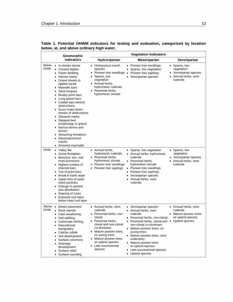
1.7 SYNTHESIS OF OHWM FEATURES
The literature reviews on hydrology (Chapter 2), geomorphology (Chapter 3), and vegetation (Chapter 4) explore in detail the connections between the magnitude, duration, frequency, and timing of flows and the development of physical characteristics of arid-land stream channels. Table 1 summarizes the geomorphic and vegetation features associated with the OHWM in arid streams. The authors found little support from the literature for sub-regional distinctions in these indicators across the arid Southwest. Therefore, they are presented as a unified regional list, pending further discussion and testing.
Potential OHWM indicators are sorted into several categories. As pointed out by Field (Chapter 3), the attempt to identify useful OHWM indicators should include “test positive” and “test negative” sets of indicators. So Table 1 presents OHWM indicators located above, at, and below the OHW boundary. In addition, vegetation indicators are sorted into the riparian wetness classes mentioned earlier—hydroriparian, mesoriparian, and xeroriparian. Hydroriparian vegetation is present in areas that are perennially saturated or inundated; mesoriparian communities are in areas that are seasonally moist; and xeroriparian communities are in areas that are mostly dry with infrequent flood events. Based on the editor’s (RWL) experience, a few of the vegetation OHWM indicators in Table 1 are listed in vegetation categories beyond where they were described and referenced in Chapter 4.
Features listed in Table 1 serve to divide the riparian area into zones extending laterally from the deepest part of the main channel. The strongest evidence of OHW are those features found consistently below the OHWM, such as crested ripples, meander bars, and hydromesic ruderal herbs. Many of these features are associated with the bottom of the channel. In contrast, strong evidence of nonjurisdictional conditions is represented by those features that are consistently above the OHWM, such as desert pavement, developed soils, and upland plant species. Together these two zones bracket a central zone within which the OHWM is located. The challenge lies in identifying a consistent and reliable OHWM within this zone.
The relationship between physical features and “ordinary” hydrologic events is difficult to establish in arid stream channels because of the extreme climatic variability that is typical of the region. Variability is also the defining characteristic of stream flows in dry-land intermittent and ephemeral stream systems. Thus, the concept of ordinary in this region must include a range of flows from the average annual or biennial high flow to some more extreme event. The occurrence of physical features resulting from both types of events may

12 ERDC TR-04-1
overlap at a site and not be easily distinguished. Occasionally very large dis-charges fill the entire floodplain beyond the area where the majority of channel-forming processes occur. Evidence of previous hydrologic events, such as drift material, may be removed and redeposited at higher elevations within the flood-plain, altering one’s perception of what is ordinary.
The indicators we identify in Table 1 contain a degree of variability as to the level of event they may represent. This makes relying on any one indicator for one point in time challenging. In addition, to avoid misinterpretation and increase consistency in applications, many of the indicators need to be refined and will require unambiguous definitions and descriptions. These will need to be devel-oped after initial testing and evaluation in a number of watersheds. Additional study may suggest the necessity to combine certain indicators or to use them only in particular positions in the watershed or landscape.
We make the following observations and suggestions about the potential OHWM indicators identified in this literature review:
• The indicators in Table 1 should not yet be used for jurisdictional purposes pending further testing and verification;
• The use of those indicators found consistently above and below OHW may be helpful in determining the area within which the OHW boundary is located;
• If possible, gauge data and local hydrology models should be used as supporting evidence until OHWM indicators are further refined and tested; and
• Other indicators not reported here may also be useful in delineating the OHW boundary.
Chapter 1. Introduction 13
Table 1. Potential OHWM indicators for testing and evaluation, categorized by location below, at, and above ordinary high water.
Vegetation Indicators
Geomorphic indicators Hydroriparian Mesoriparian Xeroriparian
Below OHW
• In-stream dunes • Crested ripples • Flaser bedding • Harrow marks • Gravel sheets to
rippled sands • Meander bars • Sand tongues • Muddy point bars • Long gravel bars • Cobble bars behind
obstructions • Scour holes down-
stream of obstructions • Obstacle marks • Stepped-bed
morphology in gravel • Narrow berms and
levees • Streaming lineations • Dessication/mud
cracks • Armored mud balls
• Herbaceous marsh species
• Pioneer tree seedlings • Sparse, low
vegetation • Annual herbs,
hydromesic ruderals • Perennial herbs,
hydromesic clonals
• Pioneer tree seedlings • Sparse, low vegetation • Pioneer tree saplings • Xeroriparian species
• Sparse, low vegetation
• Xeroriparian species • Annual herbs, xeric
ruderals
OHW • Valley flat • Active floodplain • Benches: low, mid,
most prominent • Highest surface of
channel bars • Top of point bars • Break in bank slope • Upper limit of sand-
sized particles • Change in particle
size distribution • Staining of rocks • Exposed root hairs
below intact soil layer
• Annual herbs, hydromesic ruderals
• Perennial herbs, hydromesic clonals
• Pioneer tree seedlings • Pioneer tree saplings
• Sparse, low vegetation • Annual herbs, hydromesic
ruderals • Perennial herbs,
hydromesic clonals • Pioneer tree seedlings • Pioneer tree saplings • Xeroriparian species • Annual herbs, xeric
ruderals
• Sparse, low vegetation
• Xeroriparian species • Annual herbs, xeric
ruderals
Above OHW
• Desert pavement • Rock varnish • Clast weathering • Salt splitting • Carbonate etching • Depositional
topography • Caliche rubble • Soil development • Surface color/tone • Drainage
development • Surface relief • Surface rounding
• Annual herbs, xeric ruderals
• Perennial herbs, non-clonal
• Perennial herbs, clonal and non-clonal co-dominant
• Mature pioneer trees, no young trees
• Mature pioneer trees w/ upland species
• Late-successional species
• Xeroriparian species • Annual herbs, xeric
ruderals • Perennial herbs, non-clonal • Perennial herbs, clonal and
non-clonal co-dominant • Mature pioneer trees, no
young trees • Mature pioneer trees, xeric
understory • Mature pioneer trees
w/ upland species • Late-successional species • Upland species
• Annual herbs, xeric ruderals
• Mature pioneer trees w/ upland species
• Upland species

14 ERDC TR-04-1
1.8 REFERENCES
Andrade, E.R., and W.D. Sellars (1988) El Nino and its effect on precipitation in Arizona and western New Mexico. Journal of Climatology, 8: 403–410.
Auble, G.T., J.M. Friedman, and M.L. Scott (1994) Relating riparian vegeta-tion to present and future streamflows. Ecological Applications, 4: 544–554.
Bailey, R.G. (1995) Description of the ecoregions of the United States. Second edition, reviesed and expanded (first ed. 1980). Miscellaneous Publication No. 1391 (rev.). USDA Forest Service, Washington, D.C. 108 p. with separate map at 1:7,500,000.
Bendix, J. (1994) Among-site variation in riparian vegetation of the southern California transverse ranges. American Midland Naturalist, 132: 136–151.
Brinson, M.M., B.L. Swift, R.C. Plantico, and J.S. Barclay (1981) Riparian ecosystems: Their ecology and status. FWS/OBS-81/17, U.S. Fish and Wildlife Service, Kearneysville, West Virginia.
Bendix, J. (1999) Stream power influence on southern Californian riparian vegetation. Journal of Vegetation Science, 10: 243–252.
Bevin, K., and M.J. Kirby (ed.) (1993) Channel Network Hydrology. New York: John Wiley and Sons.
Brinson, M.M. (1993) A hydrogeomorphic classification for wetlands. Technical Report WRP-DE-4, U.S. Army Engineer Waterways Experiment Station, Vicks-burg, Mississippi.
Cowardin, L.M., V. Carter, F.C. Golet, and E.T. LaRoe (1979) Classification of wetlands and deepwater habitats of the United States. FWS/OBS-79/31, U.S. Fish and Wildlife Service, Washington, D.C.
Davis, M.M., W.A. Mitchell, J.S. Wakeley, J.C. Fischenich, and M.M. Craft 1996) Environmental value of riparian vegetation. Technical Report EL-96-16, U.S. Army Engineer Waterways Experiment Station, Vicksburg, Mississippi.
Dunne, T., and L.B. Leopold (1978) Water in Environmental Planning. San Francisco: W.H. Freeman.
Ely, L.L. (1997) Response of extreme floods in the southwestern United States to climatic variations in the Holocene. Geomorphology, 19: 175–201.
Evans, J.M. (2001) Vegetation in watercourses of the eastern Mojave Desert. Fremontia, 29: 26–35.

Chapter 1. Introduction 15
Environmental Laboratory (1987) Corps of Engineers wetlands delineation manual. Technical Report Y-87-1, U.S. Army Corps of Engineer Waterways Experiment Station, Vicksburg, Mississippi.
Fanning, D.S., and M.C. Fanning (1989) Soil: Morphology, Genesis, and Classification. New York: John Wiley and Sons.
Graf, W.L. (1988) Definition of floodplains along arid-region rivers. In Flood Geomorphology (V.R. Baker, R.C. Kochel, and P.C. Patton, ed.). New York: John Wiley and Sons, p. 231–242.
Johnson, R.R., S.W. Carothers, and J.M. Simpson (1984) A riparian classifi-cation system. In California Riparian Systems: Ecology, Conservation, and Productive Management (R.E. Warner and K.M. Hendrix, ed.). Berkeley: University of California Press, p. 375–382.
Knighton, D. (1988) Fluvial Forms and Processes. New York: Oxford Univer-sity Press.
Leopold, L. (1994). A View of a River. Cambridge, Massachusetts: Harvard University Press.
Leopold, L.B., M.G. Wolman, and J.P. Miller (1964) Fluvial Processes in Geomorphology. San Francisco: W.H. Freeman.
Leopold, L.B., and W.B. Bull (1979) Base level aggradation and grade. Pro-ceedings of the American Philosophical Society, 123: 168–202.
Minckley, W.L., and D.E. Brown (1994) Wetlands. In Biotic Communities: Southwestern United States and Northwestern Mexico (D.E. Brown, ed.). Salt Lake City: University of Utah Press, p. 223–287.
Mitch, W.J., and J.G. Gosselink (1993) Wetlands. Second edition. New York: Van Nostrand Reinhold.
Meyer, J.L., L.A. Kaplan, D. Newbold, D.L. Strayer, C.J. Woltemade, J.B. Zedler, R. Beilfuss, Q. Carpenter, R. Semlitsch, M.C. Watzin, and P.H. Zedler (2003) Where rivers are born: The scientific imperative for defending small streams and wetlands. Published by American Rivers and The Sierra Club. Available at http://www.amrivers.org/docs/WhereRiversAreBorn1.pdf.
Natural Resources Conservation Service (2002) Field indicators of hydric soils in the United States. Version 5.0 (G.W. Hurt, P.M. Whited, and R.F. Pringle, ed.). USDA, NRCS in cooperation with the National Technical Committee for Hydric Soils, Fort Worth, Texas.
Pilgrim, D.H., T.G. Chapman, and D.G. Doran (1988) Problems of rainfall-runoff modeling in arid and semiarid regions. Hydrology Sciences Journal, 33: 379–400.

16 ERDC TR-04-1
Poff, N.L, J.D. Allen, M.B. Bain, J.R. Karr, K.L. Prestegard, B.D. Richter, R.E. Sparks, and J.C. Stromberg (1977) The natural flow regime: A paradigm for river conservation and restoration. Bioscience, 47: 769–784.
Reed, Jr, P.B. (1988) National list of plant species that occur in wetlands: Southwest (region 7). Biological Report 88(26.7), U.S. Fish and Wildlife Service.
Reid, I., and L.E. Frostick (1997) Channel form, flow and sediments in deserts. In Arid Zone Geomorphology: Process, Form and Change in Drylands (D.S.G. Thomas, ed.). Second edition. Chichester: John Wiley and Sons, p. 205–229.
Rosgen, D.L. (1996) Applied River Morphology. Pagosa Springs, Colorado: Wildland Hydrology.
Soil Conservation Service (1981) Land resource regions and major land resource areas of the United States. USDA Agriculture Handbook 296, Washington, D.C.
Soil Conservation Service (1994) National Food Security Act manual. Third Edition. Washington, D.C.
Stromberg, J.C. (1993) Instream flow models for mixed deciduous riparian vegetation within a semiarid region. Regulated Rivers, 8: 225–235.
Stromberg, J.C. (1998) Dynamics of Fremont cottonwood (Populus fremontii) and saltcedar (Tamarix chinensis) populations along the San Pedro River, Arizona. Journal of Arid Environments, 40: 133–155.
Szaro, R.C. (1990) Southwestern riparian plant communities: Site characteris-tics, tree species distributions, and size-class structure. Forest Ecology and Management, 33/34: 315–334.
Tiner, R.W. (1999) Wetland Indicators: A Guide to Wetland Identification, Delineation, Classification, and Mapping. Boca Raton, Florida: Lewis Publishers.
U.S. Army Corps of Engineers, South Pacific Division (2001) Final summary report: Guidelines for jurisdictional determinations for waters of the United States in the arid Southwest. U.S. Army Corps of Engineers, South Pacific Division, San Fransisco, California. http://www.spl.usace.army.mil/regulatory/ lad.htm
Wakeley, J. (2002) Developing a “regionalized” version of the Corps of Engineers wetlands delineation manual: Issues and recommendations. ERDC/EL TR-02-20, U.S. Army Engineer and Development Center, Environmental Laboratory, Vicksburg, Mississippi.
Williams, G.P. (1978) Bankfull discharge of rivers. Water Resources Research, 14: 1141–1153.

Chapter 2. Hydrology Literature Review for Ordinary High Water Mark Delineation in the Arid Southwest
JOHN J. FIELD
2.1 INTRODUCTION
Since the physical features representing Ordinary High Water (OHW) are ostensibly the result of hydrometeorological events and the resulting flows in the stream channel, a thorough examination of the hydrology and hydraulics of arid-region rivers may yield useful insights and techniques for delineating the Ordinary High Water Marks (OHWM) in the southwestern U.S.
This chapter provides a literature review of hydrology and hydraulics research, with an emphasis on the southwestern U.S. and other arid regions of the world, in order to:
• Outline the dominant climatologically and physiographic controls on rainfall–runoff processes in the Southwest;
• Discuss the strengths and weaknesses of hydrologic and hydraulics models for describing arid-region fluvial processes; and
• Identify the potential value of hydrology and hydraulic studies for delineating the OHWM in the arid Southwest.
For the purposes of this chapter, the “Southwest” is broadly defined to include all or portions of ten arid to semi-arid western states: Arizona, California, Colorado, Idaho, Nevada, New Mexico, Oregon, Utah, Wyoming, and Texas.

18 ERDC TR-04-1
2.2 HYDROLOGY
The multiple physiographic provinces in the western U.S. (Fig. 2) interact with spatially and seasonally variable moisture sources to produce a highly variable rainfall distribution pattern that is markedly different from the eastern U.S. (Fig. 3). Differing sources of moisture result in sharp seasonal differences in rainfall between climatic regions in the Southwest, while local differences in physiography and geology sometimes lead to dramatic differences in precipita-tion within a given climatic zone. A number of distinct ecological subregions, or ecosystem provinces, are present in the southwestern U.S., each resulting from a distinct assemblage of climate, physiography, and vegetation (Bailey 1983, 1995) (Fig. 4, Table 2).
Figure 2. Physiographic provinces of the western United States, showing the major provinces found in the Southwest. (Modified from De Blij and Muller 1992, Figure 52-1, p. 518.)

Chapter 2. Hydrology 19
Figure 3. Average annual precipitation in the western U.S. for 1961–1990, showing the extreme variability in rainfall in the Southwest. The precipitation totals are in inches. (From http://www.wrcc.dri.edu/images/west.gif.)

20 ERDC TR-04-1
Figure 4. Ecosystem provinces of the west-ern United States. See Table 2 for names of provinces and link to http://www.fs.fed.us/ colorimagemap/ecoreg1_provinces.html for further description of each.
Meteorological Sources of Moisture
Three sources of moisture influence precipitation patterns in the Southwest: winter North Pacific frontal storms, summer convective thunderstorms, and late-summer eastern North Pacific tropical storms (Ely 1997). The relative impor-tance of each storm type in different regions of the Southwest can be seen in the average monthly rainfall amounts for each state in the region (Table 3). Further information about rainfall in each state is available at www.wrcc.dri.edu.
North Pacific Frontal Storms
Winter North Pacific frontal storms that affect the southwestern U.S. result from low pressure systems traveling in the upper air westerly wind belt. During dry winters in the southern portions of the study area, the clockwise rotation around a high pressure ridge located just off the west coast of the U.S. tracks frontal storms to the north, impacting the Pacific Northwest (Fig. 5a). Wet winters occur when the high pressure center is displaced farther to the west, allowing the clockwise rotation to steer more frontal storms into Arizona and New Mexico (Fig. 5b).

Chapter 2. Hydrology 21
Table 2. Ecosystem provinces of the western U.S. See Figure 3 for distribution of map units. Map unit Ecosystem province
242 Pacific Lowland Mixed Forest Province M242 Cascade Mixed Forest—Coniferous Forest—Alpine Meadow Province M261 Sierran Steppe—Mixed Forest—Coniferous Forest—Alpine Meadow Province 262 California Dry Steppe Province 261 California Coastal Chaparral Forest Shrub Province
M262 California Coastal Range Open Woodland—Shrub—Coniferous Forest—Meadow Province 322 American Semidesert and Desert Province 341 Intermountain Semidesert and Desert Province
M341 Nevada-Utah Mountains Semidesert—Coniferous Forest—Alpine Meadow Province 342 Intermountain Semidesert Province 332 Great Plains Steppe Province 331 Great Plains—Palouse Dry Steppe Province
M333 Northern Rocky Mountain Forest-Steppe—Coniferous Forest—Alpine Meadow Province M331 Southern Rocky Mountain Steppe—Open Woodland—Coniferous Forest—Alpine Meadow
Province 313 Colorado Plateau Semidesert Province
M313 Arizona-New Mexico Mountains Semidesert—Open Woodland—Coniferous Forest—Alpine Meadow Province
321 Chihuahuan Desert Province 315 Southwest Plateau and Plains Dry Steppe and Shrub Province
Table 3. Summary of annual and monthly average depths of precipitation, revealing the relative importance of different moisture sources throughout the study area (except Texas). The statewide averages represent a weighted mean of the average precipitation within each climate division located in a given state. (From www.wrcc.dri.edu.)
Average Depth of Precipitation (in.) State Jan Feb Mar Apr May June July Aug Sep Oct Nov Dec Ann AZ 1.10 1.01 1.19 0.54 0.35 0.29 1.86 2.07 1.34 1.06 0.99 1.30 13.10 CA 3.77 3.28 3.13 1.52 0.61 0.27 0.18 0.35 0.58 1.25 3.14 3.35 21.43 CO 0.72 0.72 1.20 1.27 1.80 1.51 2.03 1.87 1.42 1.13 0.93 0.87 15.47 ID 2.22 1.68 1.69 1.50 1.77 1.64 0.82 0.96 1.19 1.29 2.07 2.19 19.02 NV 0.87 0.84 0.94 0.78 0.90 0.73 0.58 0.72 0.68 0.67 0.89 0.86 9.46 NM 0.59 0.60 0.63 0.57 0.92 1.17 2.27 2.58 1.87 1.17 0.73 0.75 13.85 OR 3.90 2.94 2.92 1.94 1.64 1.26 0.52 0.82 1.13 1.99 4.01 4.26 27.33 UT 0.90 0.89 1.15 1.07 1.04 0.71 0.91 1.06 1.07 1.12 1.00 0.91 11.88 WY 0.63 0.55 0.82 1.33 1.94 1.71 1.24 1.01 1.17 0.91 0.73 0.65 12.69

22 ERDC TR-04-1
Pacific Northwest
SouthwestH
a. During wet winters in the Pacific North-west and dry winters in the Southwest.
Pacific Northwest
Southwest H
b. During dry winters in the Pacific North-west and wet winters in the Southwest.
Figure 5. Positions of the North Pacific high pressure ridge and atmospheric cir-culation patterns.
In general, precipitation from winter frontal storms makes up an increasingly
large portion of the total annual rainfall farther to the north in the study area (Table 3). Flooding due to areally extensive and long-duration winter frontal storms generally occurs in large drainage basins because all portions of the drainage basin contribute to runoff. Rainfall intensities are generally too low to impact smaller, steeper watersheds.

Chapter 2. Hydrology 23
Convective Thunderstorms
Summer convective thunderstorms in the southwestern U.S. are the result of land surface heating and an influx of moist tropical air from the Gulf of Mexico, Gulf of California, and eastern tropical Pacific. This influx of tropical moisture is associated with the northwestward migration of the Bermuda high pressure ridge and the northward displacement of the Pacific high pressure cell (Bryson and Lowry 1955, Hales 1974, Carleton 1985, Douglas and Englehart 1990) (Fig. 6). This so-called “summer monsoon” is characterized by scattered convective thunderstorms that are triggered by intense surface heating and enhanced by orographic effects.
Summer precipitation totals associated with convective thunderstorms are greatest in Arizona and New Mexico, as these states are the closest to the tropical moisture sources. Uncertainty still exists as to the source of the tropical moisture fueling the monsoons, but it appears to be a combination of low-level moisture originating from the Gulf of California and eastern tropical Pacific and higher-level moisture from the Gulf of Mexico rising over the Sierra Madre mountains in Mexico (Adams and Comrie 1997). The amount of summer precipitation exhibits great interannual variability. Summer precipitation is highest in Arizona and New Mexico when a subtropical high pressure cell develops over the Four Corners region (Carleton et al. 1990). When this high pressure cell is depressed farther south, precipitation values are much lower. Small, steep watersheds are the most responsive to convective thunderstorms, as rainfall intensities are high and a single isolated storm cell can cover an entire small watershed. The isolated, short-lived nature of the thunderstorms means that runoff to larger rivers is being contributed from only a small portion of the total watershed area.
North Pacific Tropical Storms
Tropical cyclones that form off the coast of southern Mexico normally migrate northwestward over the Pacific Ocean, but occasionally the cyclones recurve toward the northeast and make landfall, usually over Baja California or western mainland Mexico (Fig. 7). Moisture from tropical cyclones is, however, occasionally drawn into Arizona, New Mexico, southern California, and southern Utah, resulting in intense precipitation and floods (Ely 1997, Farfan and Zehnder 2001), with the Tucson Flood of 1983 being a prime example (Kresan 1988). Nearly every year the remnants of tropical cyclones move into a position where the upper-level winds transport moisture and then produce showers and thunder-storms in the Southwest (Farfan and Zehnder 2001). The frequency of tropical storm recurvature is greatest in the fall (September and October), when the

24 ERDC TR-04-1
subtropical high pressure center begins to migrate southward and low pressure troughs begin to impact lower latitudes (Ely 1997).
The greatest climatic influence of North Pacific tropical storms is in Arizona, New Mexico, southern California, and southern Utah, as seen in the late summer/early fall average precipitation totals for these regions (Table 3). Tropical storms are areally extensive and have high rainfall intensities, so both large and small watersheds are prone to flooding from these events.
H
HBermuda High North Pacific High
a. During the winter months when atmospheric circulation pat-terns inhibit the influx of tropical moisture into the Southwest.
H
H
Bermuda High
North Pacific High
b. During the summer months when atmospheric circulation patterns promote the influx of tropical moisture into the Southwest.
Figure 6. Positions of the North Pacific High and Bermuda High.

Chapter 2. Hydrology 25
Figure 7. Track of Hurricane Nora in Septem-ber 1997, showing recurvature towards the southwestern U.S. (From Farfan and Zehnder 2001.)
Influence of El Niño
The El Niño/Southern Oscillation (ENSO), an unusual warming of Pacific Ocean waters, has been directly linked to increased precipitation in California and decreased precipitation in the Pacific Northwest as the North Pacific frontal storm trek is depressed farther south (Schonher and Nicholson 1989, Piechota et al. 1997, Gershunov and Barnett 1998). However, no similar link is seen between ENSO and winter rainfall in New Mexico and Arizona (Andrade and Sellers 1988). A correlation between ENSO and summer monsoonal precipitation is uncertain (Adams and Comrie 1997); some studies suggest a positive correlation (Harrington et al. 1992, Hereford and Webb 1992), while others cite no such trend (Andrade and Sellers 1988, Carleton et al. 1990). Increased fall and spring precipitation is experienced in the southwestern U.S. (principally Arizona and New Mexico) during ENSO events (Andrade and Sellers 1988). ENSO appears to be related to decadal-scale changes in precipitation patterns and flood frequency in the Southwest (i.e., the southern part of the study area defined here)(Ely 1997). The influence of ENSO events on other portions of the study area is not well studied. Relationships between long-term patterns in streamflow

26 ERDC TR-04-1
and ENSO events are similar to the precipitation patterns discussed above (Piechota et al. 1997).
Factors Controlling Runoff
Regardless of the source of precipitation, runoff in streams begins when depression storage in the watershed (e.g., ponds, small depressions) is full and the rate of rainfall exceeds the rate of infiltration (Dunne and Leopold 1978). Many factors control the ultimate timing and magnitude of runoff into streams, but only some of these factors are important for understanding differences in runoff characteristics between arid and humid climates: spatial and temporal variability of rainfall, interception, evaporation and transpiration, channel trans-mission losses, and time to the onset of runoff after rainfall begins (Pilgrim et al. 1988, Niemczynowicz 1990, Nouh 1990). In addition to these general compari-sons between humid and arid regions, the highly varied topography and soils in the Southwest (Fig. 8) lead to locally variable precipitation (and streamflow) (Fig. 3).
Arid regions are well known for highly variable spatial and temporal rainfall (Graf 1988, Pilgrim et al. 1988, Reid and Frostick 1997). Intense rains can fall in one watershed or portion of a watershed while an adjacent watershed or portion remains dry. This extreme variability, especially characteristic of summer thunderstorms, can occur in all seasons because of the variable topography in the Southwest (Fig. 9). Attempts to predict runoff from a given rainfall event in arid climates are complicated by the fact that even in small watersheds the very spotty rain makes it difficult to know precisely how much of the watershed is receiving precipitation, especially given the low density of rain gauges in desert regions (Pilgrim et al. 1988). Interannual variability in precipitation is high in arid regions, with a high ratio of record peak to average annual peak discharge (Graf 1988). Along many very arid region river systems, as in southeastern California, no flow is experienced during some years. Runoff patterns are also variable on the decadal and century scale and appear related to ENSO events (Ely 1997). Recognition of a link between ENSO and annual and longer cycles in precipita-tion holds promise for improving long-term drought and flood forecasting (Schonher and Nicholson 1989).
Interception represents that portion of the rainfall that is held on the surface of leaves and branches of trees and other vegetation. Most of this moisture is later returned to the atmosphere through evaporation, so it does not contribute to runoff in streams. Interception is likely most important with low-intensity rainfall events (Pilgrim et al. 1988), which, in the Southwest, occur during winter frontal storms. Interception is unimportant (and therefore a greater percentage of rainfall

Chapter 2. Hydrology 27
Figure 8. Soils map of the United States. (From http://www.nrcs.usda.gov/technical/land/ lgif/m4025l.gif.)
is available for runoff) in extremely arid climates where little vegetation is present. When plants are present, interception is possibly more significant in arid climates for the same vegetation density, because many desert plants are adapted to maximize stemflow (i.e., they catch and focus rainfall towards the trunk or stem) (Pressland 1975). Forest fires, an important and recurring phenomenon in the Southwest, result in temporally variable interception rates in forested water-sheds. Beyond these generalizations, little is known about interception in arid regions, and more data must be collected to improve modeling of rainfall–runoff relationships (Pilgrim et al. 1988).
Evapotranspiration accounts for 95% of precipitation in arid regions, with evaporation being far more significant than transpiration given the high percentage of bare ground (Pilgrim et al. 1988). The likelihood that soils will dry out between infrequent storm events precludes the need, in most cases, to consider antecedent moisture conditions when modeling rainfall–runoff processes.

28 ERDC TR-04-1
Figure 9. Topographic relief map of the western U.S. (Copyright Ray Sterner, Applied Physics Laboratory, The Johns Hopkins University, licensed by North Star Science and Technology, LLC, used by permission.)

Chapter 2. Hydrology 29
Transmission losses (the loss of discharge due to infiltration of flow into the channel bed) are significant along ephemeral streams (Reid and Frostick 1997, Tooth 2000). As a result, runoff can actually decrease in a downstream direction despite the increase in drainage area. For headwater streams, especially where bedrock is near the surface, transmission loss is not an important factor. Rainfall–runoff modeling must account for transmission losses, but it is difficult to model because the rate of loss varies from point to point along a channel and with the degree of saturation of the channel bed from prior events (Pilgrim et al. 1988).
Arid regions have a characteristically rapid onset of runoff after the start of a rainfall event; consequently, only a small amount of rain is needed to initiate runoff (Pilgrim et al. 1988). This is in part due to lower infiltration and intercep-tion rates compared to humid climates and in part due to generally greater rainfall intensities in arid climates. These differences underscore the need to avoid applying to arid regions assumptions about runoff characteristics developed for humid climates (Pilgrim et al. 1988).
Topography exerts a strong influence on the type, location, and amount of precipitation throughout the Southwest. Higher elevations generally experience greater precipitation than low-lying areas because of orographic effects (e.g., Sierra Nevadas; Fig. 2 and 3). Snowfall in higher regions during the winter can prevent what would have been severe flooding if the precipitation had fallen as rain. Conversely, large floods often occur when warm heavy rain falls on a deep snowpack created during earlier colder frontal storms. The presence of a snow-pack results in more consistent runoff through the spring, and even summer, along higher-elevation mountain streams while adjacent lower-elevation streams run dry. Greater vegetation at higher elevations also tends to stretch runoff over longer periods because of the increased infiltration rates. North–south-trending mountain ridges throughout the Southwest, especially in the Basin and Range Province, block moisture from eastward-moving frontal systems, creating rain shadows, or dry regions, on the east side of the mountain ridges (Fig. 2, 3, and 9). This phenomenon is manifested most dramatically by the Sierra Nevada Moun-tains, with some of the driest regions of the country found in eastern California (e.g., Death Valley) and western Nevada (Fig. 9).
The cumulative effect of all the factors controlling runoff described above is for arid-region river systems to have greater flow magnitudes, a more rapid response to rainfall, and shorter-duration flows than equivalent humid-region counterparts (Fig. 10). As a consequence, arid-region rivers are typically dry (i.e., they have no base flow) prior to a storm event. In many deserts, particularly where precipitation intensities are high, the runoff hydrograph characteristically rises very steeply as the result of limited infiltration capacity and then falls sharply in response to transmission losses (Fig. 10) (Cooke et al. 1993). The

30 ERDC TR-04-1
lower infiltration capacities and higher rainfall intensities also result in higher runoff coefficients (which express the proportion of rainfall converted to runoff) in arid regions (Knighton and Nanson 1997). Given that soil types (Fig. 8) and topography (Fig. 9) vary dramatically throughout the Southwest, even within the same physiographic province (Fig. 2) or ecosystem province (Fig. 4), average annual precipitation (Fig. 3) is equally variable and generalizations about runoff patterns by province of limited value.
Figure 10. Comparison of idealized arid-region and humid-region runoff hydrographs for the same rainfall event in watersheds of similar size and shape.
Value and Limitations of Existing Maps for Understanding Runoff Patterns
Ecosystem province designations in the western U.S. (Bailey 1983, 1995) provide the best basis for establishing hydrology-based subregions in the South-west because ecosystem provinces are delineated using those factors that exert the strongest influence on runoff patterns: vegetation, physiography, soils, and climate (Table 4). Soils maps themselves also reflect runoff characteristics and show variations within the same ecosystem province (Fig. 10).
In the Southwest, channel morphology and, as a consequence, the physical features associated with the OHWM are frequently the result of extreme floods (Graf 1988, Tooth 2000). Consequently, maps showing maximum rainfall

Chapter 2. Hydrology 31
Table 4. Precipitation and runoff characteristics for ecosystem provinces in the western U.S.
Map unit*
Dominant moisture source
Importance of snowfall
Vegetation density
Physiographic province Soil order
Character of runoff
242 winter spring runoff high Puget Lowland Andisol perennial yet flashy
M242 winter high high except above tree level
Cascades Andisol perennial yet flashy
M261 winter high high except above tree level
Coast Ranges/ Sierras
Inceptisol/ Andisol
largely perennial yet flashy
262 winter spring runoff moderate Central Valley Entisol/ Alfisol
ephemeral to south; debris flows
261 winter limited moderate Coast Ranges Alfisol/ Mollisol
ephemeral to south
M262 winter moderate high Coast Ranges Entisol/ Alfisol
ephemeral to south
322 summer/ fall
low low Basin & Range Aridisol/ Entisol
ephemeral
341 winter/ summer
moderate low–moderate in mountains
Basin & Range/Col. Plateau
Aridisol/ Entisol
ephemeral
M341 winter/ summer
moderate moderate Basin & Range/Col. Plateau
Alfisol/ Mollisol
ephemeral w/ spring runoff
342 winter moderate low Columbia Plateau
Aridisol/ Mollisol
ephemeral w/ spring runoff
332 winter moderate moderate Rocky Mtn/ Great Plains
Mollisol ephemeral w/ spring runoff
331 winter moderate moderate Rocky Mtn/ Great Plains
Mollisol ephemeral w/ spring runoff
M333 winter high high Northern Rocky Mountain
Inceptisol perennial yet flashy
M331 winter/ summer
high moderate Southern Rocky Mountain
Alfisol/ Mollisol
ephemeral w/ spring runoff
313 winter/ summer
moderate low Colorado Plateau
Aridisol/ Entisol
ephemeral
M313 winter/ summer
moderate moderate Basin and Range
Alfisol/ Inceptisol
ephemeral
321 winter/ summer
low low Great Plains/ Basin & Range
Aridisol/ Entisol
ephemeral
315 winter/ summer
low low Great Plains Mollisol ephemeral
* same as in Table 2

32 ERDC TR-04-1
intensities in the recent past, not just statistically predicted intensities for a given time duration (e.g., 10-year 24-hour storm), would be useful for identifying those areas where the channel morphology is potentially the result of a recent extreme flood. Existing data on past rainfall and stream gauges are sparsely distributed throughout the Southwest, so rainfall intensity maps may be difficult to construct. Additionally, the accuracy of such maps would be difficult to determine, given the highly localized nature of rainfall events in the Southwest (Pilgrim et al. 1988). For larger drainages influenced by more regional storms, such maps may be of greater value.
Composite maps showing climate, physiography, and geology/soils would be particularly valuable for identifying watersheds with the highest potential for channel response to extreme events (e.g., areas that can experience intense rain-fall, that have steep terrain, and where the rainfall flows through unconsolidated materials). Extreme events dominate the morphology of channels in arid climates because record peak flows are much greater than the average annual peak flow (Graf 1988). Maps developed to show variations in the ratio between record and average annual peak flows throughout the region have the potential to discrimi-nate areas where the physical features associated with the OHWM are more likely the result of extreme events. This pronounced discrepancy between record and average peak flows is ameliorated at higher elevations, where snowfall runoff leads to lower winter peaks and greater flows in the generally dryer summer. The more consistent and persistent flow throughout the year leads to channel features that are the result of more “ordinary” flows. Intense rains from tropical storms are perhaps their strongest in the driest regions of the Southwest (southeastern California and southwestern Arizona), resulting in the greatest discrepancy between record and average peaks. Consequently, channel features in these areas are more likely the result of extreme events.
Rainfall–Runoff Models
Rainfall–runoff models account for both the meteorological and physi-ographic factors that control the amount of runoff that ultimately flows in the stream channel. Those models that consider the full hydrograph resulting from a runoff event, not just the peak discharge, are more valuable since the duration of a flow, not only the peak, is important in determining the impact of flows on channel morphology (Costa and O’Connor 1995). Peak discharges for a particu-lar watershed can be estimated from regional regression equations or a statistical analysis of stream gauge data (Texas DOT 2002). Regional regression equations do not apply to watersheds with mixed-population floods, such as in the South-west, where many watersheds are affected by three distinct storm types: winter frontal storms, summer convective thunderstorms, and fall tropical cyclones.
Chapter 2. Hydrology 33
Stream gauge data are too sparsely distributed in the Southwest to provide wide-spread value in estimating peak discharges through statistical analysis.
A number of relatively simple techniques, such as the Rational Method and the Curve Number Approach, are used by the Natural Resources Conservation Service to establish crude runoff hydrographs. The Rational Method, originally designed for watersheds less than 200 acres in area, assumes uniform rainfall intensity over the whole watershed, a poor assumption in the Southwest, espe-cially for larger watersheds, where thunderstorms are highly localized. The Curve Number Approach attempts to determine the ratio of rainfall converted to runoff by establishing a “curve number” that accounts for a number of controlling variables including soil type and land use. Once a curve number is established for a watershed, only the rainfall amount is needed to determine the depth of runoff distributed over the entire watershed. Modeling programs developed by the Natural Resources Conservation Service (e.g., TR-20) are available to convert the distributed rainfall amount into a hydrograph using a dimensionless hydrograph.
The most widely used rainfall–runoff model in the United States is HEC-1 (U.S. Army Corps 1998), which creates a synthetic flood hydrograph from user-specified information about the precipitation event (e.g., duration, intensity), existing conditions (e.g., antecedent moisture), and watershed characteristics (e.g., drainage area, time of concentration, curve number). Even in arid regions, accounting for deep groundwater and antecedent moisture conditions is critical in modeling stream yields (Ye et al. 1997). A depth–area option in HEC-1 allows a user to supply information on how precipitation depths vary within the drainage area, a critical component for modeling flood hydrographs in arid areas where precipitation totals are highly variable over small areas (Pilgrim et al. 1988). However, even a relatively dense rain gauge network (one gauge per 20 km2) may be insufficient to detect convective rainfall in semi-arid regions and estimate its spatial coverage and depth (Michaud and Sorooshian 1994a). Transmission losses typical of arid regions can be modeled in the flood routing component of HEC-1 that accounts for channel and floodplain storage in various reaches along the stream. General assumptions in the model regarding the shape of the hydro-graph that apply well in temperate regions may not work as well in arid regions, where a greater proportion of the flow is due to direct runoff (shorter time to peak). As a result, the separate analysis of single events with gauge or radar rainfall information is crucial for the accurate modeling of rainfall–runoff characteristics of high-magnitude floods in arid catchments (Lange et al. 2000a). While HEC-1 and other models are capable of simulating many of the conditions present in arid regions, many of the input parameters needed are difficult to

34 ERDC TR-04-1
collect in arid regions, where rainfall data and data on physical watershed parameters (e.g., soils) are spread over wide areas.
The lack of hydrological data makes empirical methods of flood estimation in arid regions unsatisfactory, but physically based models that are calibrated in the field using measurements of soil hydrological properties offer a viable alter-native modeling strategy (El-Hames and Richards 1994). These limitations of rainfall–runoff models can be overcome by using physically based input data that can be integrated within a GIS framework to help with the management of the large data sets required (Lange et al. 2000b). Parametric runoff models, while lacking complexity, require large amounts of historical rainfall–runoff data for calibration, data that are unavailable in ungauged watersheds. To overcome these difficulties, a physically based model of an ephemeral watershed can be used to generate synthetic calibration data (Truschel and Campana 1983). The processes most important to account for in the rainfall–runoff modeling in arid regions are infiltration, soil moisture storage, rainfall spatial distribution, evaporation, and groundwater recharge (Niemczynowicz 1990). Drainage size, followed by rate of infiltration and slope of land, are the most effective catchment characteristics affecting the accuracy of some arid-region rainfall–runoff models (Nouh 1990).
Distributed rainfall–runoff models that account for spatial variations in rain-fall amounts and soil types do a better job of modeling flash floods in semi-arid regions than simple lumped methods (Michaud and Sorooshian 1994b). Other studies highlight the importance of accurately defining temporal variations in rainfall at a single point rather than establishing a dense network of rain gauges to understand spatial distributions (Nouh 1990, Krajewski et al. 1991). Rainfall–runoff models developed specifically for arid regions can more accurately account for transmission losses and other conditions characteristic of arid regions (Sharma and Murthy 1998) and overcome the limited data sets from arid regions, which inhibit the ability to calibrate such models.
A number of rainfall–runoff models, including HEC-1, have been accepted by FEMA for use in the National Flood Insurance Program (Table 5). Despite the limitations of modeling rainfall–runoff processes in arid regions, the accepted FEMA models may serve as a starting point for identifying the models most applicable for identifying the OHWM along ephemeral streams and for identify-ing the limitations that must be overcome to create reliable rainfall–runoff models for arid regions.

Chapter 2. Hydrology 35
Table 5. Rainfall–runoff models accepted by FEMA for usage in the National Flood Insurance Program. (Modified from http://www.fema.gov/fhm/ en_hydro.shtm.)
Modeling approach Computer model Available from
HEC-1 14.0.1 and up U.S. Army Corps of Engineers HEC-HMS 1.1 and up U.S. Army Corps of Engineers TR-20 Natural Resources Conservation
Service TR-55 Natural Resources Conservation
Service SWMM (RUNOFF) U.S. Environmental Protection Agency MIKE 11 UHM DHI, Inc. DBRM 3.0 University of Florida HYMO U.S. Department of Commerce PondPack v. 8 Haestad Methods, Inc.
Single event
XP-SWMM 8.52 and up XP-Software
DR3M U.S. Geological Survey HSPF 10.10 and up U.S. Environmental Protection Agency Mike 11 RR DHI, Inc.
Continuous event
PRMS Version 2.1 U.S. Geological Survey
Interior drainage analysis
HEC-IFH 1.03 and up U.S. Army Corps of Engineers

36 ERDC TR-04-1
2.3 HYDRAULICS
The OHWM is delineated on the basis of physical features present along the stream channel. Rainfall–runoff models attempt to predict the hydrologic inputs (discharge, volume, and duration of flow) entering the stream system from the surrounding watershed but do not characterize the hydraulics of the flows (width, depth, and velocity) that ultimately create the physical features associated with the OHWM. Hydraulic models are therefore needed to characterize and predict flow conditions in the stream system.
Types of Flows
Flow conditions in arid-region stream systems vary between channelized flow, sheetfloods, and debris flows. Channelized flow, mostly ephemeral in the Southwest, occurs in all settings but predominates over other flow types in valley bottom settings. Perennial channelized flow occurs in very large watersheds that extend into more humid climates (e.g., Colorado River) and in high-elevation watersheds where snowmelt can extend flow into the hot, generally dryer summer months (e.g., Colorado Rockies). Channelized flow is confined to well-defined banks and, although potentially meandering or braided, is generally unidirectional in nature (i.e., rapid expansions in flow width generally do not occur).
Sheetfloods are defined as a sheet of unconfined flood water moving down a slope (Hogg 1982). They occur in piedmont settings (the gently sloping areas between the mountains and valley bottom) and in valleys during larger storm events. Sheetfloods are generally very shallow and, unlike channelized flow, experience rapid lateral flow expansion. Sheetflood zones and channelized reaches occur together in downstream alternating sequences along discontinuous ephemeral stream systems (Schumm and Hadley 1957, Bull 1997). Unique to arid regions, discontinuous ephemeral streams are quite common in the south-western U.S. and result from the inability of most storm events to transport sediment through the entire stream system. Over time the position of sheetfloods and channelized flow on discontinuous ephemeral streams will shift such that an area of channelized flow can be transformed into a sheetflood zone over a few years or decades. Such temporal and lateral variations in flow types complicate hydraulic modeling of single storms and the long-term management of flood hazards.
Debris flows, a viscous mixture of water, mud, and coarser particles (often including large boulders), are largely restricted to mountain canyons and alluvial

Chapter 2. Hydrology 37
fans found at the mountain front. Mixed lithologies such as dolomite, quartzite, and shale produce the clay-to-boulder-sized range of particles necessary to produce debris flows during periods of high rainfall intensity in steep drainage basins. Debris flows are short-lived events (e.g., minutes to hours) that can plug deep channels (>7 m) during a single storm event, redirecting flow into new channels or over unchannelized surfaces. The viscous nature of debris flows can lead to the development of low berms along their flanks.
The occurrence of channelized flow, sheetfloods, and debris flows is spatially and temporally variable, with all three potentially occurring on the same stream system during the same flow event or at the same place through time. The characteristics and distribution of these flow types is further detailed in Chapter 3. In addition, these processes are active during only a small percentage of time, with no flow occurring in many watersheds in the Southwest more than 95% of the time. While sheetfloods and debris flows are infrequent, they exert a strong influence on the morphology of some fluvial landforms such as alluvial fans (Field 1994, Blair and McPherson 1992). On the other hand, the most frequent process, channelized flow, may have limited morphological impact. Attempts to define “ordinary” as it relates to identification of the Ordinary High Water Mark must recognize that commonly observed physical features are potentially the result of uncommon processes and that the effects of the most common condition (channelized flow or no flow at all) do not persist on the landscape.
Influence of Boundary Conditions
Runoff flowing through alluvial material (sediment deposited by the river itself) is capable of adjusting channel dimensions (width and depth) to accom-modate the runoff, so the channel morphology along alluvial reaches reflects the flow conditions in the stream channel. Where the streambanks consist of easily erodible sand material, the channel adjusts its width more rapidly than depth, so shallow, braided channelized flows or sheetfloods are more likely than deeper channelized flows. Where banks are richer in clay and silt, channel depth adjusts more rapidly, so deeper channelized flows are more common.
Where runoff passes through nonalluvial material (i.e., bedrock or sediments that the river cannot move), the flow is not capable of adjusting channel dimen-sions, so the channel morphology is more reflective of the resisting forces of the bank material rather than the flow itself. For example, adjustments in channel width cannot occur in bedrock canyons, so the flow width of an extreme event may be very similar to that of a more-frequent (e.g., annual) event. Given that the extent of flow may be similar, regardless of flow magnitude, the delineation of

38 ERDC TR-04-1
the OHWM may be easier in some nonalluvial settings compared to alluvial channels.
Hydraulic Models
The most widely used hydraulic model in the United States is HEC-RAS, which is an updated version of the once widely used HEC-2 model (U.S. Army Corps of Engineers 2002). HEC-RAS is a one-dimensional flow model that predicts flow velocity, width, and depth for a given discharge if the cross sectional area, gradient, and Manning’s roughness value are known. Conversely, the HEC-RAS model can calculate the discharge necessary to reach a certain stage in the stream channel, which is especially useful for calculating the discharge of past flow events where the high water mark is preserved (O’Connor and Webb 1988). The high water mark for a given flow can be identified from hydrologic flow indicators such as the highest presence of silt, flotsam, or trim lines. Such hydrologic high water marks may be representative of the OHWM when found in conjunction with geomorphic or vegetation indicators, such as the height of the active floodplain or the lower level of perennial vegetation. As a one-dimensional model, HEC-RAS largely assumes that discharge is constant through time and space, conditions that rarely hold in nature, especially in arid climates. Sheetflood and debris flow conditions are especially difficult to model using HEC-RAS because of rapidly expanding flow and highly variable viscosity of flow, respectively.
Two-dimensional models are more capable of accounting for the spatial and temporal variations in flow conditions associated with arid-region river systems, but the increased analytical complexity associated with two-dimensional modeling has, to date, precluded its wide acceptance as a predictive tool in watershed management. Two-dimensional hydraulic models have been developed that are capable of characterizing several features and processes typical of arid-region rivers such as rapid width adjustments (Darby 1998), erodible banks (Mosselman 1998), multiple threaded braided channels (Lane and Richards 1998), debris flows (O’Brien et al. 1993), flow around obstructions such as boulders (Crowder and Diplas 2000), and transmission losses (El-Hames and Richards 1998). However, two-dimensional models are not yet capable of modeling all of these conditions and their complex interactions simultaneously, as occurs during natural flows in ephemeral channels. Two-dimensional models can accurately recreate conditions observed during known flows, but the exten-sive calibration necessary with actual conditions precludes their use for predic-tive purposes. With time and increasing computing power, these models hold promise to be of much greater value than at present.

Chapter 2. Hydrology 39
Three-dimensional models are also becoming available and are useful for modeling secondary circulation associated with the confluence of tributaries (Bradbrook et al. 1998). While these conditions exist along ephemeral streams, they are more localized phenomenon and are not of great importance in under-standing flow at the reach or watershed level. Three-dimensional models are important, however, for identifying the limitations of two-dimensional models and for identifying the needs of future model development (Bradbrook et al. 1998).
A number of hydraulic models, including HEC-RAS and several two-dimensional models, have been accepted by FEMA for use in the National Flood Insurance Program (Table 6). Despite the limitations of hydraulic modeling, the accepted FEMA models may serve as a starting point for identifying the models most applicable for identifying the OHWM along ephemeral streams and for identifying the limitations that must be overcome to create reliable hydraulic models for arid regions. Wide use of complex two- and three-dimensional models is unlikely in the near future because of the detailed data collection required and the difficulty in mastering the large-scale computer models (Leopardi et al. 2002). Additionally, it is unlikely that a single model will suffice for every situation, and it is important that model performance be evaluated with respect to specific field problems (e.g., delineation of the OHWM) as they are encountered (Lane 1998).
Usefulness of Hydrology and Hydraulics for Delineating the OHWM
Hydrological parameters such as precipitation inputs and watershed charac-teristics determine the amount of runoff entering a stream channel. The hydrau-lics of the flow in the stream exerts a force on the channel boundary, which in turn shapes the morphology of the channel. Although hydrology and hydraulics are extremely important in modeling and predicting flow in channels, they are unable to determine the ultimate channel morphology and physical features that develop along a stream in response to a flow event of a given size (e.g., ordinary or extreme flows). The development of channel morphology is not only depend-ent on the flow conditions but also on sediment inputs and boundary conditions along the channel, two aspects not adequately addressed in current hydrologic and hydraulic models.
While hydrologic and hydraulic models may be insufficient to predict the types and location of OHWM features, they can be extremely useful for recon-structing the flow conditions responsible for developing the physical features associated with the OHWM (see Chapter 3 for a list of these potential features). Channel cross sections and estimates of Manning’s roughness coefficient, along

40 ERDC TR-04-1
Table 6. Hydraulic models accepted by FEMA for usage in the National Flood Insurance Program. (Modified from http://www.fema.gov/fhm/ en_hydra.shtm.)
Modeling approach Computer model Available from
HEC-RAS 3.0 and 3.1 U.S. Army Corps of Engineers HEC-2 4.6.2 U.S. Army Corps of Engineers WSPRO Federal Highway Administration FLDWY U.S. Department of Commerce QUICK-2 1.0 and up Federal Emergency Management
Agency HY8 4.1 and up Federal Highway Administration WSPGW 12.96 Joseph E. Bonadiman & Associates,
Inc. StormCAD v. 4 and v. 5 Haestad Methods, Inc. PondPack v. 8 Haestad Methods, Inc. Culvert Master v. 2.0 Haestad Methods, Inc.
One-dimensional steady flow
XP-SWMM 8.52 and up XP-Software
HEC-RAS 3.0 and 3.1 U.S. Army Corps of Engineers FEQ 8.92 U.S. Geological Survey FEQUTL 4.68 U.S. Geological Survey ICPR 2.20 and 3.02 Streamline Technologies, Inc. SWMM 4.30 and 4.31 U.S. Environmental Protection
Agency UNET 4.0 U.S. Army Corps of Engineers FLDWAV National Weather Service MIKE 11 HD DHI, Inc. FLO-2D v. 2000.11 FLO-2D Software, Inc.
One-dimensional unsteady flow
XP-SWMM 8.52 and up XP-Software
TABS RMA2 v. 4.3 U.S. Army Corps of Engineers TABS RMA4 v. 4.5 U.S. Army Corps of Engineers FESWMS 2DH 1.1 and up U.S. Geological Survey FLO-2D v. 2000.11 FLO-2D Software, Inc.
Two-dimensional steady/unsteady flow
MIKE Flood HD DHI, Inc.
SFD Federal Emergency Management Agency
Floodway analysis
PSUPRO Federal Emergency Management Agency
Chapter 2. Hydrology 41
with the elevation of the identified OHWM, can be used to reconstruct the dis-charge necessary to emplace the given OHWM. This could be accomplished with one-dimensional or two-dimensional hydraulic models, depending on the degree of accuracy and computational effort desired. Once the discharge is estimated, the recurrence interval for that flow could be established to determine if the identified OHWM is the result of an extreme event or more frequently occurring flows. Conversely, if a recurrence interval is established that represents the “ordinary” flow, then the depth of flow associated with the OHWM along any given channel could be established. Such an approach, however, does not guar-antee that the river stage associated with the chosen “ordinary” discharge will be consistent with the level at which the physical OHWM features are found. Once the flow conditions associated with the OHWM are established, various combi-nations of rainfall conditions (e.g., amount, intensity) and physical watershed parameters (e.g., drainage area, antecedent moisture conditions) necessary to create the given discharge could be modeled.
Comparisons of hydraulic model results from different watersheds and eco-regions could be used to determine if there is a general agreement in the recur-rence interval of flows associated with identified OHWM features. Given the highly variable temporal and spatial distribution of rainfall in the Southwest and the slow channel recovery times after extreme events, congruence between recurrence intervals over wide areas seems unlikely. Hydrology and hydraulic studies will be extremely valuable, however, for identifying those physiographic, climatic, or ecological subregions where there is consistency in the recurrence interval of the “ordinary” flow (i.e., the flow responsible for creating the OHWM) from one watershed to the next.

42 ERDC TR-04-1
2.4 CONCLUSIONS
Variable moisture sources and the complex physiography in the Southwest-ern U.S. results in a highly variable spatial and temporal distribution of precipi-tation and stream flow. Differences in watershed size and relief ensure that the stream response to a single precipitation event can vary between watersheds even within the same physiographic or ecological subregion. Consequently, regional generalizations about runoff patterns are difficult to make, and watershed-specific studies will be necessary to accurately delineate the OHWM.
Physical features associated with the OHWM are more readily identified using geomorphic methods, but hydraulic and hydrologic studies are potentially valuable for establishing the discharge recurrence intervals and runoff conditions, respectively, responsible for forming the OHWM features. Numerous hydrologic (Table 5) and hydraulic (Table 6) models are available for characterizing runoff and flow conditions associated with the OHWM, but no single model is likely to be superior in all situations. Comparing discharge recurrence intervals responsi-ble for the development of the OHWM between watersheds holds the greatest promise for concluding whether OHWM features throughout the Southwest, or within specific subregions, are consistently formed by events of the same mag-nitude (i.e., frequent or extreme events) or whether such OHWM features are formed by events of varying magnitude because of the overriding influence of watershed characteristics, channel boundary conditions, and highly variable rainfall intensities.
Chapter 2. Hydrology 43
2.5 REFERENCES
Adams, D.K., and A.C. Comrie (1997) The North American monsoon. Bulletin of the American Meteorological Society, 78: 2197–2213.
Andrade, E.R., and W.D. Sellers (1988) El Niño and its effect on precipitation in Arizona and western New Mexico. Journal of Climatology, 8: 403–410.
Bailey, R.G. (1983) Delineation of ecosystem regions. Environmental Manage-ment, 7: 365–373.
Bailey, R.G. (1995) Description of the ecoregions of the United States. U.S. Forest Service, available at http://www.fs.fed.us/land/ecosysmgmt/ecoreg1_ home.html.
Blair, T.C., and J.G. McPherson (1992) The Trollheim alluvial fan and facies model revisited. Geological Society of America Bulletin, 104: 762–769.
Bradbrook, K.F., P.M. Biron, S.N. Lane, K.S. Richards, and A.G. Roy (1998) Investigation of controls on secondary circulation in a simple confluence geometry using a three-dimensional numerical model. Hydrological Processes, 12: 1371–1396.
Bryson, R.A., and W.P. Lowry (1955) Synoptic climatology of the Arizona summer precipitation singularity. Bulletin of the American Meteorological Society, 36: 329–339.
Bull, W.B. (1997) Discontinuous ephemeral streams. Geomorphology, 19: 227–276.
Carleton, A. (1985) Synoptic and satellite aspects of the southwestern US summer ‘monsoon.’ Journal of Climatology, 5: 389–402.
Carleton, A.M., D.A. Carpenter, and P.J. Weser (1990) Mechanisms of interannual variability of the Southwest United States summer rainfall maximum. Journal of Climate, 3: 999–1015.
Cooke, R., A. Warren, and A. Goudie (1993) Desert Geomorphology. London: UCL Press.
Costa, J.E., and J.E. O’Connor (1995) Geomorphically effective floods. In Natural and Anthropogenic Influences in Fluvial Geomorphology (J.E. Costa, A.J. Miller, K.W. Potter, and P.R. Wilcock, ed.). Geophysical Monograph 89. Washington, D.C.: American Geophysical Union, p. 45–56.
Crowder, D.W., and P. Diplas (2000) Using two-dimensional hydrodynamic models at scales of ecological importance. Journal of Hydrology, 230: 172–191.
44 ERDC TR-04-1
Darby, S.E. (1998) Modelling width adjustment in straight alluvial channels. Hydrological Processes, 12: 1299–1321.
De Blij, H.J., and P.O. Muller (1992) Physical Geography of the Global Environment. New York: John Wiley and Sons.
Douglas, A.V., and P.J. Englehart (1990) Relationship between summertime ridge position and continental rainfall regimes, 1929-1988. Proceedings of the 14th Annual Climate Diagnostics Workshop, National Oceanic and Atmospheric Administration, Washington, D.C., p. 108–114.
Dunne, T., and L.B. Leopold (1978) Water in Environmental Planning. San Francisco: W.H. Freeman.
El-Hames, A.S., and K.S. Richards (1994) Progress in arid-lands rainfall–runoff modeling. Progress in Physical Geography, 18: 343–365.
El-Hames, A.S., and K.S. Richards (1998) An integrated, physically based model for arid region flash flood prediction capable of simulating dynamic transmission loss. Hydrological Processes, 12: 1219–1232.
Ely, L.L. (1997) Response of extreme floods in the southwestern United States to climatic variations in the late Holocene. Geomorphology, 19: 175–201.
Farfan, L.M., and J.A. Zehnder (2001) An analysis of the landfall of Hurricane Nora (1997). Monthly Weather Review, 129: 2073–2088.
Field, J.J. (1994) Surficial processes, channel change, and geological methods of flood hazard assessment on fluvially dominated alluvial fans in Arizona. Ph.D. thesis, University of Arizona, Tucson.
Field, J. (2003) Fluvial geomorphology literature review for Ordinary High Water Mark indicators in the arid Southwest. Unpublished report, U.S. Army Corps of Engineers.
Gershunov, A., and T.P. Barnett (1998) ENSO influence on intraseasonal extreme rainfall and temperature frequencies in the contiguous United States: observations and model results. Journal of Climate, 11: 1575–1586.
Graf, W.L. (1988) Definition of floodplains along arid-region rivers. In Flood Geomorphology (V.R. Baker, R.C. Kochel, and P.C. Patton, ed.). New York: John Wiley and Sons, p. 231–242.
Hales, J.J. (1974) Southwestern United States summer monsoon source, Gulf of Mexico or Pacific Ocean? Weatherwise, 24: 148–155.

Chapter 2. Hydrology 45
Harrington, J.A., Jr., R. Cerveny, and R. Balling, Jr. (1992) Impact of the Southern Oscillation on the North American Monsoon. Physical Geography, 13: 318–330.
Hereford, R., and R. Webb (1992) Historical variations of warm-season rainfall, southern Colorado Plateau, southwestern U.S.A. Climate Change, 22: 239–256.
Hogg, S.E. (1982) Sheetfloods, sheetwash, sheetflow, or ...? Earth-Science Reviews, 18: 59–76.
Knighton, D., and G. Nanson (1997) Distinctiveness, diversity and uniqueness in arid zone river systems. In Arid Zone Geomorphology: Process, Form and Change in Drylands (D.S.G. Thomas, ed.). Second Edition. Chichester: John Wiley and Sons, p. 185–203.
Krajewski, W.F., V. Lakshmi, K.P. Georgakakos, and S.C. Jain (1991) A Monte Carlo study of rainfall sampling effect on a distributed catchment model. Water Resources Research, 27: 119–128.
Kresan, P.L. (1988) The Tucson, Arizona, flood of 1983: Implications for land management along alluvial river channels. In Flood Geomorphology (V.R. Baker, R.C. Kochel, and P.C. Patton, ed.). New York: John Wiley and Sons, p. 465-489.
Lane, S.N. (1998) Hydraulic modelling in hydrology and geomorphology: A review of high resolution approaches. Hydrological Processes, 12: 1131–1150.
Lane, S.N., and K.S. Richards (1998) High resolution, two-dimensional spatial modelling of flow processes in a multi-thread channel. Hydrological Processes, 12: 1279–1298.
Lange, J., C. Leibundgut, N. Greenbaum, and A.P. Schick (2000a) Modelling high magnitude events in large arid catchments—A field based approach in Nahal Zin, Israel. Publication 248, IAHS-AISH, p. 561–567.
Lange, J., C. Liebundgut, and A.P. Schick (2000b) The importance of single events in arid zone rainfall-runoff modeling. Physics and Chemistry of the Earth, Part B: Hydrology, Oceans and Atmosphere, 25: 673–677.
Leopardi, A., E. Oliveri, and M. Greco (2002) Two-dimensional modeling of floods to map risk-prone areas. Journal of Water Resources Planning and Management, 128: 168–178.
Michaud, J.D., and S. Sorooshian (1994a) Effect of rainfall sampling errors on simulations of desert flash floods. Water Resources Research, 30: 2765–2775.

46 ERDC TR-04-1
Michaud, J.D., and S. Sorooshian (1994b) Comparison of simple versus complex distributed runoff models on a midsized semiarid watershed. Water Resources Research, 30: 593–605.
Mosselman, E. (1998) Morphological modelling of rivers with erodible banks. Hydrological Processes, 12: 1357–1370.
Naiman, R.J., H. Decamps, and M. Pollock (1993) The role of riparian corri-dors in maintaining regional biodiversity. Ecological Applications, 3: 209–212.
Niemczynowicz, J. (1990) Some examples of important problems connected to rainfall-runoff modelling in semi-arid zone. The State-of-the-Art of Hydrology and Hydrogeology in the Arid and Semi-arid Areas of Africa, Proceedings of the Sahel Forum, Ouagadougou, 1989, p. 255–266.
Nouh, M. (1990) Flood hydrograph estimation from arid catchment morphology. Hydrological Processes, 4: 103–120.
O’Brien, J.S., P.Y. Julien, and W.T. Fullerton (1993) Two-dimensional water flood and mudflow simulation. Journal of Hydraulic Engineering, 119: 244–260.
O’Connor, J.E., and R.H. Webb (1988) Hydraulic modeling for paleoflood analysis. In Flood Geomorphology (V.R. Baker, R.C. Kochel, and P.C. Patton, ed.). New York: John Wiley and Sons, p. 393–402.
Pilgrim, D.H., T.G. Chapman, and D.G. Doran (1988) Problems of rainfall–runoff modeling in arid and semiarid regions. Hydrological Sciences Journal, 33: 379–400.
Piechota, T.C., J.A. Dracup, and R.G. Fovell (1997) Western US streamflow and atmospheric circulation patterns during El Nino-Southern Oscillation. Journal of Hydrology, 201: 249–271.
Pressland, A.J. (1975) Rainfall partitioning by an arid woodland (Acacia aneura F. Muell.) in south western Queensland. Australian Journal of Botany, 21: 235–245.
Reid, I., and L.E. Frostick (1997) Channel form, flow and sediments in deserts. In Arid Zone Geomorphology: Process, Form and Change in Drylands (D.S.G. Thomas, ed.). Second Edition. Chichester: John Wiley and Sons, p. 205-229.
Sharma, K.D., and J.S.R. Murthy (1998) A practical approach to rainfall–runoff modelling in arid zone drainage basins. Hydrological Sciences Journal, 43: 331–348.
Schonher, T., and S.E. Nicholson (1989) The relationship between California rainfall and ENSO events. Journal of Climate, 2: 1258–1269.

Chapter 2. Hydrology 47
Schumm, S.A., and R.F. Hadley (1957) Arroyos and the semiarid cycle of erosion. American Journal of Science, 255: 161–174.
Texas Department of Transportation (DOT) (2002) Hydraulic Design Manual 2002-2. Hydraulics Branch, Bridge Division.
Tooth, S. (2000) Process, form and change in dryland rivers: A review of recent research. Earth-Science Reviews, 51: 67–107.
Truschel, A.D., and M.E. Campana (1983) Parametric model for peak flow prediction in ungaged ephemeral watersheds. OWRT-B-122-NEV(1), Water Resources Center, Nevada University System, Reno.
U.S. Army Corps of Engineers (1998) HEC-1 Flood Hydrograph Package User’s Manual. Davis, California: Hydrologic Engineering Center.
U.S. Army Corps of Engineers (2001) Final summary report: Guidelines for jurisdictional determinations for waters of the United States in the arid Southwest. Unpublished report, South Pacific Division, U.S. Army Corps of Engineers.
U.S. Army Corps of Engineers (2002) HEC-RAS River Analysis System User’s Manual. Davis, California: Hydrologic Engineering Center.
Ye, W., A.J. Jakeman, B.C. Bates, N.R. Viney, and M. Sivapalan (1997) Performance of conceptual rainfall-runoff models in low-yielding ephemeral catchments. Water Resources Research, 33: 153–166.

Chapter 3. Fluvial Geomorphology Literature Review for Ordinary High Water Mark Indicators
in the Arid Southwest
JOHN J. FIELD
3.1 INTRODUCTION
The extent of riverine waters in temperate regions of the United States has generally been taken as those areas that are below the Ordinary High Water Mark (OHWM). How successfully these morphological features can be applied to rivers in the arid Southwest is unclear. To address uncertainties in delineating the OHWM along rivers in the Southwest, a fuller understanding of fluvial processes and forms that develop in arid climates is necessary. This chapter provides a literature review of fluvial geomorphology research in arid regions of the world with the purpose of:
• Outlining the dominant stream types and processes found in arid regions; • Comparing arid-region fluvial processes and forms with humid-region
counterparts; • Identifying morphological features that might prove useful for
delineating the OHWM in arid regions; and • Revealing potential problems that may arise when attempting to
delineate the OHWM in arid regions. Five major stream system types are found in desert regions:
• Discontinuous ephemeral streams; • Compound channels; • Alluvial fans; • Anastomosing rivers; and • Single-thread channels with adjacent floodplains.

Chapter 3. Geomorphology 49
Many of the processes acting on arid-region river systems (e.g., channelized flow, sheetfloods) may be associated with more than one of these five stream types, but differences in the spatial and temporal distribution of processes give rise to the distinctive stream types.
After a brief summary of basic principles in fluvial geomorphology, this chapter will describe the processes associated with the five arid-region stream types and the resulting morphological features that develop. The reasons that the different stream types develop and the ways in which they differ from humid-region perennial rivers are provided, followed by methods that may prove useful in identifying the OHWM. The focus of this review is on alluvial channel forms in arid regions (i.e., channels formed in river-deposited sediment) and does not address bedrock channel forms in similar climates, recently described by Wohl (1993) and Wohl et al. (1994).

50 ERDC TR-04-1
3.2 PRINCIPLES OF FLUVIAL GEOMORPHOLOGY
Equilibrium and Dominant Discharge
A basic principle of fluvial geomorphology is the concept of equilibrium, which holds that a river channel’s form—its cross sectional shape, planform, and gradient—is adjusted to the prevailing watershed conditions that control the amount of sediment and water delivered to the channel (Leopold et al. 1964, Leopold and Bull 1979). The concept of a graded stream was similarly defined by earlier workers but focused more on the river’s gradient, with less attention to cross sectional shape and planform (e.g., Mackin 1948). Channels are self-adjusting and will change their morphology in response to changing watershed conditions (Dunne and Leopold 1978) but only if the threshold of critical power necessary to precipitate change is crossed (Bull 1979).
The dominant, or effective, discharge in a particular region generally controls the size and shape of the river channel. The effects of smaller flows that tend to decrease the size of the channel are reworked with subsequent larger flows. Conversely, larger flows that can increase the size of a channel generally occur too infrequently for the impact on the river channel to persist on the landscape. More frequent events, in concert with revegetation, tend to “heal” the impacts of larger flows and return the channel to a size in equilibrium with the dominant sediment and water discharge. The discharge at which channel maintenance is most effective often corresponds to the bankfull stage where water completely fills the channel and begins to spread out onto the floodplain (Dunne and Leopold 1978). In other words, the bankfull discharge governs the shape and size of the channel (Rosgen 1996). While the bankfull discharge has been shown to have, on average, a recurrence interval of 1.5 years (Dunne and Leopold 1978, Rosgen 1996), enough exceptions to this rule occur that one should not assume that this average value holds for any given channel (Williams 1978).
While many of these basic concepts in fluvial geomorphology evolved, in part, from early research in semi-arid climates (see, for example, Leopold et al. 1964), the general applicability of the equilibrium concept to desert regions has been called into question (Tooth 2000). The effects of extreme events persist in deserts for long periods because of the inability of the stream channel to recover or “heal” from large floods, in part due to the absence of sufficient revegetation (Baker 1977, Graf 1988a). A further discussion of equilibrium, dominant discharge, and their application to desert regions is provided later in this chapter.

Chapter 3. Geomorphology 51
Terrace Development
In response to significant long-term changes in watershed conditions, a river channel will alter its dimensions to accommodate changes in the delivery of sediment and water to the river channel. A typical response is for the channel gradient to change, which can lead to significant changes in the channel bed elevation. Watershed perturbations that result in a decrease in sediment supply will lead to bed lowering, leaving the previous channel and floodplain isolated above the newly established channel level. These abandoned floodplain and channel surfaces are referred to as terraces that formed under a previous hydro-logic regime (Fig. 11).
Figure 11. River terraces along Wadi Mujib, Jordan. The river terraces are the flat surfaces high above the well-vegetated channel bottom.
The effects of repeated climate changes during the Quaternary are manifested along many rivers and piedmonts in the southwestern U.S. as a series of terraces, the youngest of which formed during the Holocene or at the Pleistocene-Holocene transition about 10,000 years ago (Basel and Royse 1972, Bull 1991, Reneau 2000). Tectonism can also create a succession of terraces with hundreds of feet of total relief (Schumm et al. 2000).
While many terraces are high above the active channel, others exhibit little relief above the current channel so are sometimes difficult to distinguish from the

52 ERDC TR-04-1
active floodplain (Dunne and Leopold 1978), an important distinction to make if one delineates the OHWM based on the bankfull stage. Relief above the active channel is not a reliable measure, by itself, of whether a surface is isolated from flooding, but in conjunction with several weathering features (e.g., rock varnish, desert pavement) can provide strong evidence that a surface is a terrace, not an active floodplain (Field and Pearthree 1997). These weathering features, as discussed later, may prove to be reliable indicators of areas that are definitively above the OHWM. These distinctions are important because large superfloods, with the possibility of recurring under the current hydrologic regime, can create terraces along dryland rivers (Schick 1974, Schick and Magid 1978).

Chapter 3. Geomorphology 53
3.3 STREAM SYSTEM TYPES
Discontinuous Ephemeral Streams
Discontinuous ephemeral streams form a distinctive stream pattern charac-terized by alternating erosional and depositional reaches (Fig. 12) (Schumm and Hadley 1957, Patton and Schumm 1975, Bull 1997, Field 2001). The longitudinal distribution of processes and morphologies along one discontinuity can be repeated multiple times along a stream, with the length of individual discontinuities ranging from 15 m to over 10 km, depending on drainage area (Bull 1997).
Overland flow emanates from the unconfined sheetflood zones and aggrading downstream ends of channels. The reconcentration of the overland flow creates erosional knickpoints at the downstream end of sheetflood zones that migrate
Figure 12. Schematic plan view and longitudinal profile of a discontinuous ephemeral stream system, showing the relationship between sheetflood zones, depositional and erosional channels, overland flow zones, and bank heights (not to scale). (Modified from Field 2001.)

54 ERDC TR-04-1
Figure 13. Wide, shallow ephemeral stream channel with a nearly horizon-tal, planar bed on Wild Burro Wash near Marana, Arizona.
headward over time. Immediately downstream of the headcuts, the channels are narrow, with steep vertical banks and erosional beds. Discontinuous gravel lags are found on the bed of the erosional channels (Field 1994). Flows will rarely overtop the banks just downstream of the headcuts, as overland flow is more likely to be generated where bank heights are much lower or nonexistent. Incised reaches of washes in Arizona contain channels floored with coarse-grained sediments and flanked by berms of fine-grained sediment (Wells 1977).
Downstream of the erosional channels (Fig. 12), the channels widen, promoting deposition of the sediments supplied from the eroding reach upstream (Patton and Schumm 1981). The bed topography in these reaches is subdued, with braided flow possible. The beds of single-thread channels in arid climates are nearly horizontal and planar (Fig. 13), as opposed to the more-pronounced pool–riffle morphologies characteristic of more humid regions (Reid and Frostick 1997). Bar forms are flat-topped and rise only 10–20 cm above the channel thalweg (Leopold et al. 1966), because secondary flow cells that would encourage bar building are suppressed in the wider channels (Reid and Frostick 1997). The tail end of a flood will carve wide, shallow channels across the bars as the waning flows occupy the lowest portions of the channel bottom.
As water spreads out onto the sheetflood zones (Fig. 14), gravel trains can form behind obstructions (usually vegetation) and scour at the sides and down-stream end of the obstruction (Blair 1987, Field 1994). Distributary channels

Chapter 3. Geomorphology 55
Figure 14. Unconfined sheetflood zone on Wild Burro Wash near Marana, Arizona. Note the organic debris in the foreground deposited by the most recent sheetflood.
form at the apex of the sheetflood zones and continue to branch out (becoming smaller and smaller and less distinct as they do) before terminating in elongated sand tongues of low positive relief. Particle sizes decrease rapidly downstream, from sand to silt and clay, as the sediment load drops out with the rapidly decelerating flow. Since flow is more easily diverted at lower velocities, the flood waters become reconcentrated into broad, gentle swales before ending at headcuts carved by the reconcentrated sediment-starved flow. Reconvergence of flow has been observed during natural sheetfloods (McGee 1897, Packard 1974) and at the toe of distributary areas on experimental fans (Schumm et al. 1987). Additionally, floodouts described from Australia appear similar to sheetflood zones and exhibit the reconcentration of flow at their downstream ends (Tooth 1999, 2000). [Floodouts are sedimentary basins formed at the endpoints of primary or distributary fluvial systems where channeled flow ceases and flood-waters spill across adjacent alluvial surfaces (Bourke and Zimbelman, 2001).] McGee’s (1897) first description of sheetfloods in Sonora, Mexico, and southern Arizona is very similar to the processes described here for discontinuous ephem-eral streams and fits Hogg’s (1982) definition of sheetfloods as “a sheet of unconfined flood water moving down a slope.”

56 ERDC TR-04-1
The downstream decrease in discharge arising from transmission losses (i.e. water infiltrating into the channel bed) typical of ephemeral streams (Reid and Frostick 1997, Tooth 2000) means that the sediment load cannot be transported equally through each reach during a single flow (Bull 1997). This results in a buildup of the channel-floor elevation, especially during low- and intermediate-stage flows (Packard 1974), and gives rise to the distinctiveness of discontinuous ephemeral stream systems. The optimal hydrometeorological conditions for their formation appear to be 100–500 mm of annual rainfall (Bull 1997). The semi-arid climate maximizes sediment yield (Tooth 2000) while allowing for sufficient vegetation growth to trap sediment on sheetflood zones (Packard 1974). With transmission losses further inducing deposition, sheetflood zones and headcuts migrate upstream over time. Sediment has a tendency to move through dryland rivers episodically (Schumm and Hadley 1957), as a series of waves (Lekach and Schick 1983, Schick et al. 1987, Graf 1988b). Consequently, scour and fill are unlikely to be synchronized, with erosion occurring in one reach while another reach is simultaneously aggrading (Tooth 2000).
The morphological changes observed in a downstream direction along dis-continuous ephemeral stream systems are the same changes that occur at a single point through time as the various reaches migrate headward. Consequently, temporal variations in morphology are extreme. Channel backfilling caused by the headward migration of aggradational reaches can transform a deep channel into an area of sheetflooding over periods of tens to hundreds of years (Bull 1997). The buildup of slope resulting from aggradation ultimately leads to retrenching of the same area once the threshold of critical power is crossed (Patton and Schumm 1975, Bull 1979). Numerous studies in the Southwest have documented the repeated cutting and filling of arroyos along discontinuous ephemeral stream systems during the Holocene (Antevs 1952, Patton and Schumm 1981, Waters and Haynes 2001).
Vertical-walled arroyos, entrenched ephemeral streams that form in desert environments (Fig. 15) (Waters and Haynes 2001), are best understood as erosional channels in discontinuous ephemeral stream systems (Fig. 11). Where rates of erosion exceed those of aggradation, continuous arroyos can form on valley floors because headcuts will advance headward faster than the aggrading sheetflood zones. This situation can arise when conditions result in a long-term increase in water:sediment ratios (Packard 1974) associated with climate change, destruction of vegetation cover, or artificial flow concentration (Cooke et al. 1993). Arroyos evolve and backfill over time, as has been the case for many arroyos in the 20th century (Emmett 1974). As the initial vertical walls and narrow channel of the arroyo begin to widen, stream power is lost, sediment:water ratios decrease, and vegetation takes hold in the channel,

Chapter 3. Geomorphology 57
Figure 15. Arroyo Chico in the Rio Puerco Watershed, New Mexico, show-ing entrenched vertical walls typical of arroyos. (From http://rocky web.cr.usgs.gov/html/puerco/chico.html.)
resulting in aggradation. Aggradation can continue until the incised channel is completely backfilled and the valley floor has no well-defined channel, a condition that existed in the southwestern United States prior to 1850 (Leopold and Miller 1956). Exposures along existing arroyo walls contain evidence that arroyo cutting and subsequent filling has occurred several times throughout the Holocene (Waters and Haynes 2001). Incision of arroyos occurs relatively rapidly (a few years to decades), while subsequent backfilling is a much slower process (several decades to centuries). While some have linked arroyo formation to climate change (Bryan 1941, Balling and Wells 1990, Waters and Haynes 2001) and human land use (Antevs 1952, Graf 1983a, Bull 1997), arroyos can also occur endogenetically (Andres 1980) as localized oversteepening of aggra-dational reaches occurs during the natural evolution of a discontinuous ephemeral stream system under steady hydrological conditions (Patton and Schumm 1975).
While a discontinuous ephemeral stream system as a whole might be considered to be in equilibrium if the amount of channelized area relative to sheetflood zones remains constant over time, a single point along the system never reaches a steady state. Channel morphology will constantly be in flux, even if headcuts and sheetflood zones are migrating headward at the same rate to maintain equilibrium. Dramatic temporal and spatial changes in channel mor-phology should be considered the norm, rather than the exception, on discontinuous ephemeral stream systems.
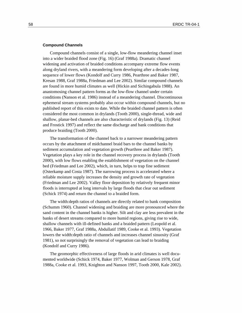
58 ERDC TR-04-1
Compound Channels
Compound channels consist of a single, low-flow meandering channel inset into a wider braided flood zone (Fig. 16) (Graf 1988a). Dramatic channel widening and activation of braided conditions accompany extreme flow events along dryland rivers, with a meandering form developing after a decades-long sequence of lower flows (Kondolf and Curry 1986, Pearthree and Baker 1987, Kresan 1988, Graf 1988a, Friedman and Lee 2002). Similar compound channels are found in more humid climates as well (Hickin and Sichingabula 1988). An anastomosing channel pattern forms as the low-flow channel under certain conditions (Nanson et al. 1986) instead of a meandering channel. Discontinuous ephemeral stream systems probably also occur within compound channels, but no published report of this exists to date. While the braided channel pattern is often considered the most common in drylands (Tooth 2000), single-thread, wide and shallow, planar-bed channels are also characteristic of drylands (Fig. 13) (Reid and Frostick 1997) and reflect the same discharge and bank conditions that produce braiding (Tooth 2000).
The transformation of the channel back to a narrower meandering pattern occurs by the attachment of midchannel braid bars to the channel banks by sediment accumulation and vegetation growth (Pearthree and Baker 1987). Vegetation plays a key role in the channel recovery process in drylands (Tooth 2000), with low flows enabling the establishment of vegetation on the channel bed (Friedman and Lee 2002), which, in turn, helps to trap fine sediment (Osterkamp and Costa 1987). The narrowing process is accelerated where a reliable moisture supply increases the density and growth rate of vegetation (Friedman and Lee 2002). Valley floor deposition by relatively frequent minor floods is interrupted at long intervals by large floods that clear out sediment (Schick 1974) and return the channel to a braided form.
The width:depth ratios of channels are directly related to bank composition (Schumm 1960). Channel widening and braiding are more pronounced where the sand content in the channel banks is higher. Silt and clay are less prevalent in the banks of desert streams compared to more humid regions, giving rise to wide, shallow channels with ill-defined banks and a braided pattern (Leopold et al. 1966, Baker 1977, Graf 1988a, Abdullatif 1989, Cooke et al. 1993). Vegetation lowers the width:depth ratio of channels and increases channel sinuosity (Graf 1981), so not surprisingly the removal of vegetation can lead to braiding (Kondolf and Curry 1986).
The geomorphic effectiveness of large floods in arid climates is well docu-mented worldwide (Schick 1974, Baker 1977, Wolman and Gerson 1978, Graf 1988a, Cooke et al. 1993, Knighton and Nanson 1997, Tooth 2000, Kale 2002).
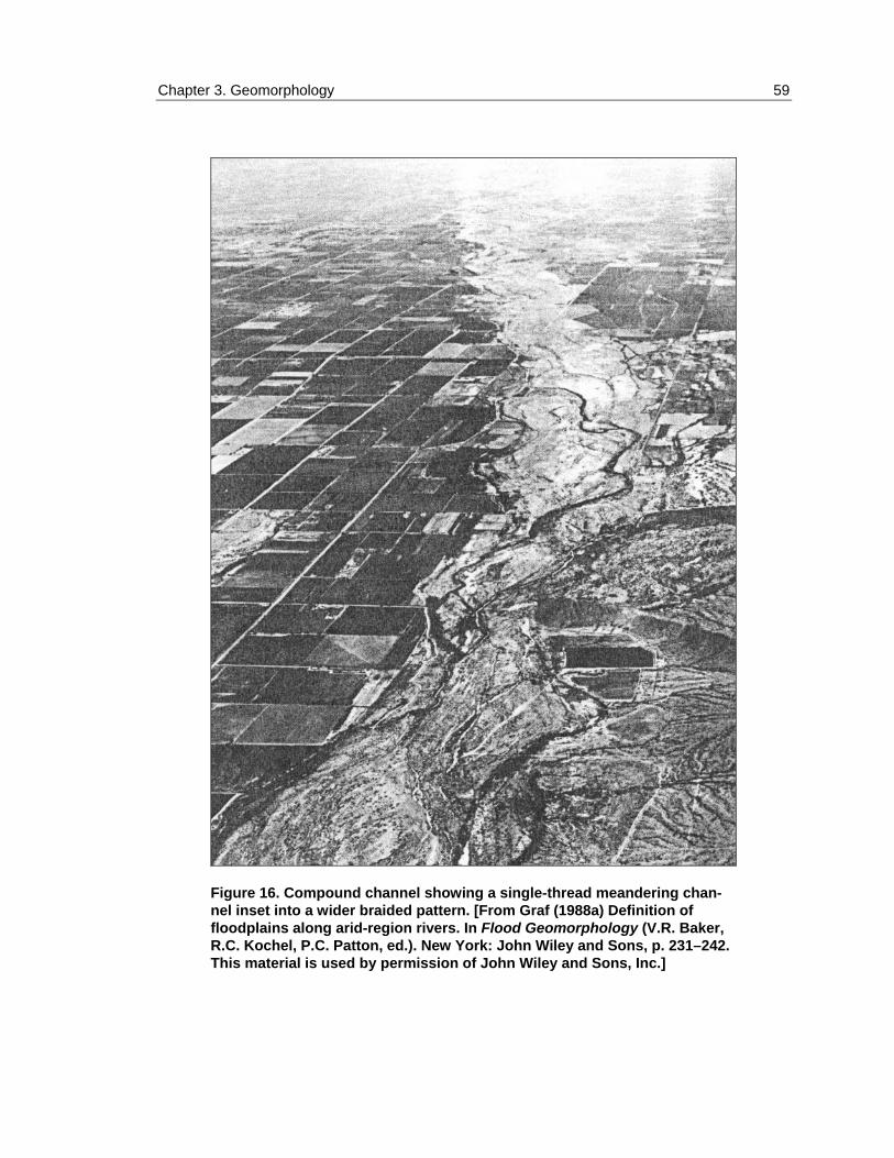
Chapter 3. Geomorphology 59
Figure 16. Compound channel showing a single-thread meandering chan-nel inset into a wider braided pattern. [From Graf (1988a) Definition of floodplains along arid-region rivers. In Flood Geomorphology (V.R. Baker, R.C. Kochel, P.C. Patton, ed.). New York: John Wiley and Sons, p. 231–242. This material is used by permission of John Wiley and Sons, Inc.]

60 ERDC TR-04-1
Arid-region river channels, especially those with sandy banks, are often very responsive to large flows and recover slowly from them because of the limited vegetation growth and the large interannual variability in peak discharges (Cooke et al. 1993, Tooth 2000). Nonexistent or poor armoring of ephemeral stream beds (Reid and Laronne 1995) increases the sensitivity of the river channel to a range of flow events and hinders the ability of the river to “hold” any one pattern. Consequently, desert rivers are often in a perpetual state of change—working to recover from a large flood but unable to “heal” completely before the next extreme event widens the channel and renews the process (Cooke et al. 1993, Tooth and Nanson 2000a). Unambiguous morphological features indicative of the OHWM are unlikely under these conditions since channel morphology is in a state of flux, with high water marks being constantly reworked. The faster the rate of revegetation and the longer the time interval between threshold-crossing extreme events, the greater the likelihood that the recovery process will result in the development of reliable OHWM indicators. Conversely, the slower the recovery process, the greater the likelihood that the high water mark indicators present along the channel are the result of extreme events. In certain instances, recovery is delayed even further because the effects of extreme events control the processes that occur during subsequent smaller events (Graf 1983b, Bourke and Pickup 1999). Regardless of the rate of recovery, dramatic temporal and spatial changes in channel morphology and position should be considered the norm, rather than the exception, along compound channels. A stable channel form is never really achieved because the rate of recovery is slower than the return interval of extreme events that alter the landscape.
Alluvial Fans
Alluvial fans are depositional landforms with a conical shape that develop where confined streams emerge from upland areas into zones of reduced stream power (Fig. 17) (Harvey 1997). While alluvial fans are found in almost all climates (Nilsen and Moore 1984, Rachocki and Church 1990), they are an especially important landscape element in the southwestern United States, where an estimated 31% of the land surface is covered by alluvial fan deposits (Antsey 1966). Alluvial fans are characterized by a distributary flow pattern (Bull 1977, Tooth 2000) with debris flow (Beaty 1963, Blair and McPherson 1992, Whipple and Dunne 1992), sheetflood (Blair 2000), and streamflow (Blissenbach 1954, Field 2001) processes predominating; all three processes are not necessarily active on all fans, however. Debris flows are intermediate between landslides and water flooding, with sediment concentrations ranging from 70 to 90% by weight; sediment and water move together as a slurry at the same velocity (Ritter et al. 1995). Poorly channelized braided flow is characteristic of streamflow processes

Chapter 3. Geomorphology 61
Figure 17. Conical shape and distributary flow pattern developed on an alluvial fan at the bottom of the Grand Canyon where Bright Angel Creek enters the Colorado River.
on alluvial fans in arid regions (Cazanacli et al. 2002). The type of process that predominates on a particular fan depends on several factors, including lithology (Blair 1999), climate (Hooke 1967, Bull 1977, Harvey 1992), and drainage area (Hooke and Rohrer 1979, Harvey 1984, Waters and Field 1986).
Channel avulsions—the rapid diversions of flow from one channel into another due to blockage of the channel by sediment or debris —are not unique to alluvial fans (Schumann 1989, Gay et al. 1998), but they are very important in the development and maintenance of the conical shape (Fig. 18) (Field 2001). Debris flow fans provide dramatic examples of avulsions caused by the blockage of deep (>7 m) channels and incision of new equally deep channels elsewhere on the fan surface (Chawner 1935, Kesseli and Beaty 1959, Morton and Cambell 1974, Whipple and Dunne 1992). While the location of new channels is more difficult to predict on debris flow fans, avulsions on streamflow-dominated fans typically occur where banks are low and always occupy a pre-existing flow path (Fig. 18) (Field 2001). Overland flow generated by discontinuous ephemeral stream systems active on many fan surfaces in southern Arizona leads to avulsions (Field 2001).
Five distinct channel morphologies are associated with different stages of the avulsion process on alluvial fans in southern Arizona (Fig. 19). The changes in morphology through time at a single point reflect the rapid channel enlargement

62 ERDC TR-04-1
Figure 18. Aerial photographs of Ruelas Fan near Marana, Arizona, taken in 1936 and 1988, showing an avulsion that occurred between 1949 and 1956. The arrow, in the same posi-tion on both photos, highlights the pre-existing channel reach into which flow was diverted. The letter "a", indicating the fan apex, is in the same position on both photos. (Modified from Field 2001.)

Chapter 3. Geomorphology 63
Figure 19. Five channel morphologies observed on alluvial fans in southern Arizona. Note that a single channel reach can go through each phase of channel development through time, and each stage of development can be observed at different places on a fan at the same time. (Modified from Field 2001.)
accompanying an avulsion and the subsequent slow backfilling of the channel due to a series of low-flow events. As the channels evolve through the morphological steps, they become increasingly unstable, explaining why avulsions preferentially occur where banks are low (Field 2001). The dramatic temporal and spatial changes in channel morphology and position associated with channel avulsions should be considered the norm, rather than the exception, on alluvial fans.
Large portions of many piedmonts in the Southwest, the gently sloping plains between mountain ranges and valley bottoms, have been isolated from alluvial fan flooding for 10,000 years or more (Field and Pearthree 1997). These inactive alluvial fans do not need to be managed as flood-prone zones and form by multi-ple processes including long-term tectonic quiescence (Eckis 1928, Harvey 1987), tectonic uplift (Beaty 1961, Hooke 1967), climate change (Hunt and Mabey 1966, Silva et al. 1992), and base-level fall (Drew 1873, Wasson 1977). Geomorphological analysis and mapping can be used to delineate these active areas and thus identify those areas most susceptible to flooding (Fig. 20) (Rhoads 1986, Kenny 1990, French et al. 1993, Field and Pearthree 1997). A number of in-situ weathering, erosional, and pedogenic features can be used to distinguish flood-prone areas from inactive zones (Table 7), including desert pavement, rock varnish, and salt-split cobbles (Fig. 21).

64 ERDC TR-04-1
Figure 20. Geomorphic map of alluvial fan surfaces on the southwestern piedmont of the White Tank Mountains, Arizona. Only Unit Y2 is active, so the location of the OHWM would be restricted to within these areas. (From Field and Pearthree 1997.)

Chapter 3. Geomorphology 65
a. Desert pavement and rock varnish (dark tone).
b. Close-up of desert pavement and rock varnish.
c. Salt-split cobble.
Figure 21. Well-developed weathering fea-tures on an inactive alluvial fan surface on the piedmont of White Tank Mountains, Ari-zona.

66 ERDC TR-04-1
Table 7. Surface features that develop in the absence of fluvial activity. See Field and Pearthree (1997) for a more extensive list of references. (After Field and Pearthree 1997.)
Surface feature Reference Weathering
Desert pavement Al Farraj and Harvey (2000), Dorn (1988)
Rock varnish Derbyshire and Owen (1990), Ritter (1986)
Clast weathering Derbyshire and Owen (1990), McFadden et al. (1989)
Salt splitting Hooke (1972) Carbonate etching Hooke (1972) Depositional topography Bull (1991),
McFadden et al. (1989)
Soils Soil development Mohindra et al. (1992),
Harden and Matti (1989)
Caliche rubble Dorn (1988), Lattman (1973)
Surface color/tone Dorn (1988), Lattman (1973)
Vegetation Hooke (1972) Erosion
Drainage development Dorn (1988), Rhoads (1986)
Surface relief Hooke (1972), Rhoads (1986)
Surface rounding Dorn (1988)
Anastomosing Rivers
Anastomosing rivers are sinuous, low-gradient channels consisting of multi-ple interconnected branches transporting a suspended or mixed load (Fig. 22) (Schumann 1989). In plan view the splitting and rejoining of anastomosing channel branches may at first appear similar to braiding, but many distinct differ-ences exist (Fig. 16 and 22). Whereas flow is fairly evenly divided amidst differ-ent braided flow paths, one main channel is characteristic of anastomosing channels, with only overbank flow feeding smaller anabranches. Given the high suspended load content and fine-grained bank material, channel width:depth ratios are lower and sinuosities higher than for braided rivers. Also, channel position is more stable along anastomosing rivers. Anastomosing channels can

Chapter 3. Geomorphology 67
Figure 22. Anastomosing channels along Cooper Creek, Australia. Note the primary channel that is active during low flows running from left to right across the center of the photo. (Copyright, Colin P. North, University of Aberdeen, Scotland; used by permission.)
also form in sand-bed rivers where vegetation serves as a stabilizing influence (Wende and Nanson 1998, Tooth and Nanson 2000b). While anastomosing rivers are mostly reported from different climates in Australia (Tooth 2000), they are present in the arid western U.S. (Schumann 1989, Malisce 1993) but are not common in the Southwest, given the necessary prerequisites of high suspended load and/or dense vegetation.
Channel avulsions are an important process in the development of anasto-mosing rivers, with overland flow from the main channel enlarging and ultimately capturing the smaller anabranches (Schumann 1989). While avulsions on braided rivers tend to occur by lateral migration of banks (Cazanacli et al. 2002), avulsions on anastomosing systems are generally the result of the head-ward extension of anabranches (Schumann 1989). Processes within the main channel may be similar to meandering rivers, with the formation of cut banks and point bars, but the relief of such features is generally lower in arid climates (Malisce 1993). The morphological evolution of anastomosing river channels and their relationship to avulsions share many similarities to discontinuous ephemeral streams on alluvial fans (Fig. 19) (Field 2001). The development of benches at the base of the main channel due to bank sloughing leads to greater overland flow, which drives the avulsion process (Schumann 1989). As on alluvial fans, the dramatic temporal and spatial changes in channel morphology and position

68 ERDC TR-04-1
associated with channel avulsions should be considered the norm, rather than the exception, on anastomosing rivers.
Single-Thread Channels with Adjacent Floodplains
Single-thread, generally meandering channels with adjacent floodplains are characteristic of humid climates but do occur in drylands (Fig. 11) (Graf 1988b). They occur where a dependable water supply is present, as in allogenic rivers (i.e. rivers that drain watersheds extending into more humid climates, such as the Colorado River) (Tooth 2000). Meandering is more pronounced with vegetation (Merritt and Cooper 2000), partially explaining why single-thread channels in arid climates tend toward a lower sinuosity (Schumm 1961). Dryland perennial rivers have morphologies similar to those known for humid regions (Cooke et al. 1993), where vegetation and more constant flow are able to stabilize banks and form vertically accreting floodplain surfaces rather than laterally unstable compound channels. Transmission losses (Reid and Frostick 1997) and debris flow inputs from tributaries (Graf 1979, Webb et al. 1988) are unique occurrences in drylands that may alter the characteristic perennial river form. Decreasing width:depth ratios during large floods may compensate for the decreasing discharge downstream along allogenic rivers (Deodhar and Kale 1999). To the extent that dryland perennial rivers mimic their humid-region counterparts, a stable channel form may develop, and delineation of the OHWM becomes easier.

Chapter 3. Geomorphology 69
3.4 DIFFERENCES AMONG STREAM TYPES
A number of factors contribute to the development of differences between dryland and humid-region rivers (Table 8) and among stream types within drylands. Channel morphology and position are highly variable, both spatially and temporally, on most dryland rivers due to limited vegetation, unstable sandy banks, transmission losses, and high interannual variability in peak discharges. Smaller drainage basins have a greater sensitivity to large floods, especially in arid climates, where stream widths remain largely unchanged for drainage areas exceeding 50 km2 due to transmission losses (Wolman and Gerson 1978). Dis-continuous ephemeral stream systems and alluvial fans are most prevalent in, but not restricted to, piedmont settings. Compound channels, anastomosing rivers, and single-thread channels with adjacent floodplains generally occupy the valley bottoms.
Bedrock lithology and soils play a strong role in the size of sediment available and consequently the processes that occur in dryland streams. Discontinuous ephemeral steam processes are enhanced in granitic terrains and with other lithologies that weather to sand and finer particles, as this ensures that sediment is mobilized during even low to moderate flows (Wells 1997, Blair 1999, Field 2001). Drainage basins with mixed lithologies such as dolomite, quartzite, and shale produce clay to boulder-sized particles necessary for the formation of debris flows, a dominant process on some alluvial fans (Blair 1999).
Table 8. Comparison of hydrologic and channel characteristics of arid- and humid-region rivers. (After Knighton and Nanson 1997.) Characteristics Arid-region rivers Humid-region rivers
Low and unreliable Relatively high and dependable Limited duration but high-intensity storms Long-duration precipitation of variable
intensity Extreme annual variability in peak discharges
Less temporal variability in peak discharges
Precipitation events of limited spatial extent
Large areas generally affected
Transmission losses downstream Tributary inputs downstream Ephemeral flow Perennial flow
Hydrologic characteristics
Sharply peaked runoff hydrograph Runoff hydrographs have lower amplitude
Floods as major channel formers Channels adjusted to frequent discharges Long recovery time after disturbance Quicker channel recovery
Channel characteristics
Transient behavior dominant Tendency for channels to reach equilibrium

70 ERDC TR-04-1
Anastomosing patterns are enhanced when the clay and silt content in the channel exceeds 80%, as can occur when the surrounding bedrock is largely claystones and shale (Schumann 1989). Otherwise, soils in arid regions have limited clay because hydrolysis of feldspars and ferromagnesium minerals occurs very slowly with the limited moisture. Very coarse material on a streambed, as is produced by fine-grained volcanics, quartzites, and carbonates in arid regions, increase the geomorphic effectiveness of large floods because of the high response threshold required to scour and rework bouldery deposits (Baker 1977). Consequently the morphological features observed in such drainages, especially in arid climates, are more likely the result of extreme floods and not smaller-magnitude events.
Floods in the arid Southwest usually result from one of three kinds of storms: tropical cyclones with regional extent and intense rainfalls; convective thunder-storms of limited extent but intense rainfall; and winter low-pressure frontal storms from the Pacific Ocean with regional extent but lower rainfall intensities (Ely 1997). Convective thunderstorms affect smaller drainage basins but are generally too localized to produce significant flows on larger rivers. Winter frontal storms, in contrast, can produce moderate flows on larger rivers but have limited impact on small drainage basins that often respond only to flashier flows. When widespread low-intensity rainfall from frontal storms is accompanied with local high-intensity convective storms, large volumes of runoff may result (Burkham 1988). Tropical cyclones have the potential to dramatically impact both large and small drainages (Kresan 1988) but are less common than the other storm types. In many deserts, particularly where precipitation intensities are high, the runoff hydrograph characteristically rises very steeply as the result of limited infiltration capacity and then falls sharply in response to transmission losses (Cooke et al. 1993). The lower infiltration capacities and higher rainfall intensities result in higher runoff coefficients (which express the proportion of rainfall converted to runoff) in arid regions (Knighton and Nanson 1997). The floods most likely to result in significant geomorphic change are those that produce discharges many times above that normally experienced by the river, that is, those with high ratios of maximum peak discharge to mean annual discharge (Kochel 1988). Such high ratios are characteristic of arid regions (Graf 1988a, Knighton and Nanson 1997). Humid-region rivers tend to respond less dramatically to floods because interannual variability in peak discharges is much lower.
The sequencing of prior flood events is critical for understanding the channel morphology observed at any given time (Graf 1988a). A series of low flows over a number of years may produce a smaller channel inset into a compound channel that would be particularly sensitive to morphological change during an extreme event. When two large storms occur close in time, the second event is generally
Chapter 3. Geomorphology 71
less effective since the channel has already adjusted its morphology to accommodate high discharges (Kochel 1988).
Vegetation exerts a strong influence on the morphology and stability of stream channels (Millar 2000). Rivers with vegetated channel banks have channel widths half that of their weakly vegetated equivalents (Hey and Thorne 1986). Hydraulic geometry relationships that reflect how channel width, depth, and velocity change with varying discharges consistently show the channel width changing more rapidly with discharge in drylands compared to humid regions (Park 1977). Regional curves show the width increasing more rapidly with drainage area in semi-arid climates (Rosgen 1996). Consequently, braiding (Fig. 16) and sheetflooding (Fig. 14) are more common in arid regions where dense riparian vegetation is lacking. Lateral instability also arises with an absence of bank vegetation (Millar 2000). By inhibiting widening and lateral migration, vegetation leads to the vertical accretion of sediments and the development of floodplains. The effectiveness of large floods is diminished when flow energy is dissipitated on a floodplain, ensuring that the channel morphologies present where vegetation is dominant are reflective of the frequent low flows in the region. Understanding the different processes, patterns, and sensitivities to change that result from various watershed characteristics (e.g., bank vegetation, bank composition, drainage size and lithology, hydrology) is critical for distinguishing between morphological features formed by extreme floods compared with the more frequent low flows.
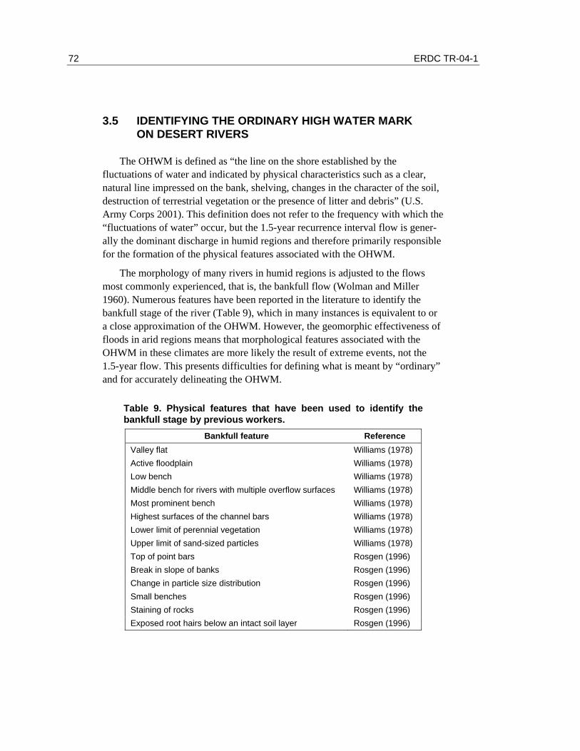
72 ERDC TR-04-1
3.5 IDENTIFYING THE ORDINARY HIGH WATER MARK ON DESERT RIVERS
The OHWM is defined as “the line on the shore established by the fluctuations of water and indicated by physical characteristics such as a clear, natural line impressed on the bank, shelving, changes in the character of the soil, destruction of terrestrial vegetation or the presence of litter and debris” (U.S. Army Corps 2001). This definition does not refer to the frequency with which the “fluctuations of water” occur, but the 1.5-year recurrence interval flow is gener-ally the dominant discharge in humid regions and therefore primarily responsible for the formation of the physical features associated with the OHWM.
The morphology of many rivers in humid regions is adjusted to the flows most commonly experienced, that is, the bankfull flow (Wolman and Miller 1960). Numerous features have been reported in the literature to identify the bankfull stage of the river (Table 9), which in many instances is equivalent to or a close approximation of the OHWM. However, the geomorphic effectiveness of floods in arid regions means that morphological features associated with the OHWM in these climates are more likely the result of extreme events, not the 1.5-year flow. This presents difficulties for defining what is meant by “ordinary” and for accurately delineating the OHWM.
Table 9. Physical features that have been used to identify the bankfull stage by previous workers.
Bankfull feature Reference Valley flat Williams (1978) Active floodplain Williams (1978) Low bench Williams (1978) Middle bench for rivers with multiple overflow surfaces Williams (1978) Most prominent bench Williams (1978) Highest surfaces of the channel bars Williams (1978) Lower limit of perennial vegetation Williams (1978) Upper limit of sand-sized particles Williams (1978) Top of point bars Rosgen (1996) Break in slope of banks Rosgen (1996) Change in particle size distribution Rosgen (1996) Small benches Rosgen (1996) Staining of rocks Rosgen (1996) Exposed root hairs below an intact soil layer Rosgen (1996)

Chapter 3. Geomorphology 73
Table 10. Advantages and disadvantages of different methods for defining the OHWM in arid regions.
Method for defining OHWM Advantages Disadvantages
Geomorphically effective event
- Less ambiguous to delineate in the field
- Good for establishing probable maximum flood
- Extraordinary events delineated, not ordinary
Exclusion of areas above and below OHWM
- Definitively removes areas from consideration as either above or below the OHWM
- Less likely to lead to false positives - Provides a means of checking the accuracy of determinations established by another method
- Provides only range of area within which the OHWM is located, so less precise
Recognition of the transitory nature of desert rivers
- Accounts for dominant process in arid regions
- Maximum limit of the OHWM delineated
- More precise than geomorphically effective approach when long time since last flood
- Temporal in nature and difficult to define spatially
- Imprecise
Hydrologic/hydraulic methods
- Precise elevation of the OHWM established
- Uncertainties in use of gauges in desert regions
- Possible inconsistencies with physical features
Consequently four approaches for delineating the OHWM in arid regions are described below with a description of the potential advantages and disadvantages of each approach (Table 10): identification of the limits of the geomorphically effective event; exclusion of areas definitively above and below the OHWM; recognition of the transitory tendency of arid-region rivers; and application of hydrologic and hydraulic methods.
Identification of Limits of Geomorphically Effective Events
In humid regions the geomorphically effective event, or the flow that leaves the most lasting impression on the landscape, is the bankfull flow. Thus, using the limits of the geomorphically effective event to delineate the OHWM is essentially the current practice in humid regions. Applying the same concept to arid regions would be straightforward in terms of identifying physical features on the ground, but the outer limits of extreme flows would be delineated, not the annual flow.

74 ERDC TR-04-1
While many of the same features used to identify bankfull features could be used in this approach (e.g., highest surface of bars, rock staining, change in particle size distribution), others might not apply (e.g., lower limit of perennial vegetation, exposed root hairs, active floodplain). Additional features not associated with a bankfull condition might also be useful for identifying the limits of extreme events in arid regions (e.g., outermost or highest scour lines and silt lines, micro-terraces). While morphological features associated with low flows may develop within a compound channel, these features would be continually changing as the channel narrows after the passing of a large flood.
The value of identifying the limits of geomorphically effective events would be to remove the uncertainty of whether the low-flow channels represent physical features associated with more “ordinary” flow conditions or some intermediate condition between the ordinary and extreme events. Given that arid-region rivers generally respond to large floods by dramatically widening their banks, the limits of the geomorphically effective event will likely be much more extensive than the limits of a low-flow channel inset into a compound channel. Consequently, if the OHWM is set at the outer limits of the extreme event, the designated “waters” will encompass a much greater area than is occupied by more ordinary flows.
Exclusion of Areas Definitively Above and Below the OHWM
Precise location of the OHWM is especially difficult in arid regions where the morphological features present on the landscape are possibly the result of:
• Flow events of various magnitude (e.g., high-flow and low-flow channels of compound channels);
• Multiple processes (e.g., sheetfloods and streamflows on discontinuous ephemeral streams); or
• No longer active processes (e.g., channels abandoned by avulsion on alluvial fans and anastomosing streams).
Given these uncertainties, a more effective approach to locating the OHWM may be to identify areas on the land surface that are definitively above or below the OHWM. Vast portions of piedmonts and valley bottoms in the Southwest have been removed from active fluvial processes for thousands, in many places hundreds of thousands, of years (Field and Pearthree 1997). Once isolated from the influence of flooding, a distinctive suite of weathering, erosional, and pedogenic features develop that become more pronounced with age (Table 7). Areas where these features are found can be considered above the OHWM since they have not been inundated by floods for several millennia. Not all of the

Chapter 3. Geomorphology 75
features presented in Table 7 will be present at a given site, but using multiple features is more reliable than using single features for establishing the relative length of time that different areas have been isolated from fluvial processes (McFadden et al. 1989). The degree of development of each feature can be quantified and a threshold value established that could be used to determine if the area was safely above the OHWM.
A number of sedimentary structures are associated with ephemeral streams (Table 11), and the presence of fresh undisturbed features at a given location would be evidence of recent fluvial activity. Whether the structures present were deposited by normal low flows or by an extreme flood may be difficult to ascertain, so their occurrence would only be definitive evidence of being below the limits of the geomorphically effective flood. They would represent only possible evidence for being below the extent of the average annual flow unless their presence is coupled with additional information indicating that no signifi-cant flow events had occurred in the watershed for a significant period of time. The features listed in Table 11 are easily disturbed, so if no extreme flow events had occurred in the past decade or so, their presence in pristine condition would likely be the result of low flows. Determinations of whether an area is defini-tively below the OHWM would be strengthened by the presence of multiple sedimentary structures. Many of the features in Table 11 are common to all of the five stream system types described above and thus would be widely applicable.
Delineating the OHWM by this exclusionary approach would require identi-fying along a given river cross section those areas that are definitively above the OHWM (Table 7) and those areas definitively below the OHWM (Table 11). The OHWM itself would then be located in the zone between those areas excluded. The area not excluded would likely encompass areas inundated by extreme floods since these zones would not possess fresh sedimentary structures (assum-ing that no recent extreme flood has occurred) nor would they have well-developed weathering features that form only when fluvial activity ceased thousands of years before.
The exclusionary approach will not lead to precise determinations but will provide a definitive way of identifying zones within which the OHWM is located and could serve as a check on other techniques; the OHWM delineated by another method should fall within the zone identified using the exclusionary approach. In some cases delineation of the OHWM using the exclusionary approach will constrain the location of the OHWM to a fairly narrow zone, such as in narrow valleys or where there is large relief between river terraces and the active flood zone. In other areas the zone might be quite wide and perhaps of limited usefulness in reasonably locating the OHWM. A wide zone of uncer-tainty, however, may be an accurate reflection of the uncertainties present on the

76 ERDC TR-04-1
ground surface. Therefore, an exclusionary approach, while less precise than other methods, is less likely to lead to false identifications of the OHWM.
Table 11. Sedimentary structures common to ephemeral streams. See Picard and High (1973) for additional structures.
Sedimentary structure Reference Dunes and megadunes - sand bed rivers Malisce (1993)
Williams (1970) Karcz (1972)
Mud drapes Reid and Frostick (1997)
Sand tongues Packard (1974)
Cobble bars/trains behind obstructions Field (1994) Blair (1987)
Scour holes downstream of obstructions Field (1994) Picard and High (1973)
Transverse sinuous crested ripples Tooth (1999)
Flaser bedding - ripples covered by mud Martin (2000)
Narrow berms and levees Malisce (1993) Wells (1977)
Muddy point bars of low relief Malisce (1993)
Longitudinal gravel bars Malisce (1993)
Gravel sheets grading to rippled sands Malisce (1993)
Streaming lineations Malisce (1993) Picard and High (1973)
Dessication/mud cracks Abdullatif (1989) Glennie (1970)
Stepped-bed morphology in gravel Bowman (1977)
Meander bars Karcz (1972)
Harrow marks - flow aligned sand ridges Karcz (1972)
Obstacle marks Karcz (1972)
Armored mud balls Picard and High (1973)
Recognition of the Transitory Tendency of Arid-Region Rivers
Rivers in any climatic region are always adjusting to changes in watershed conditions in a direction that will bring the river into equilibrium with the new conditions. Given the wide discrepancy in record and average annual peak flows

Chapter 3. Geomorphology 77
in arid regions and the high sensitivity of arid-region rivers to change, dryland rivers rarely reach a state of equilibrium (Graf 1988a, Tooth and Nanson 2000a). Rivers in arid regions respond to large floods by widening their banks. During periods of low flow, these rivers reduce their channel’s size to attain equilibrium with the reduced discharge. A constantly transitory state results because the time needed to establish equilibrium with the low-flow conditions is greater than the frequency of large floods that create a larger channel in equilibrium with the high discharge. Immediately after a large flood, the channel will begin to narrow, and the trend will be towards a smaller and smaller channel. Thus, the morphological features generally associated with the OHWM (Table 9) will in successive years be inset into features emplaced previously, as long as a large flow event does not occur. Therefore, the actual location of the OHWM, the one that would be estab-lished if the river reached an equilibrium condition, should be considered to be at some point below the current position of the physical features normally associ-ated with the OHWM (Table 9).
With this approach the physical features associated with the OHWM will continue to develop and become more pronounced through time until the next subsequent extreme event reworks the emerging OHWM features. The physical features identified on the ground would be considered to be at some level above the OHWM, and as such, this approach provides a means of establishing the maximum possible extent of “waters.” If a large flood has recently passed through the river system, then the physical features mapped on the ground would be high above or outside the actual OHWM. Conversely, if a long time has passed since an extreme event, then the physical features mapped would be close to the OHWM as the channel continues to shrink in the absence of an extreme event. Studies of flood histories and historical aerial photographs could help establish whether the channel is approaching an equilibrium condition or just beginning the recovery process after passage of a large flood.
Application of Hydrologic and Hydraulic Methods
If the OHWM is assumed to occur at a level reached by the discharge at a specified recurrence interval, then hydrologic and hydraulic methods can be used to establish to what level along the channel this discharge would reach, regard-less of whether any physical features on the ground are associated with this synthetically determined stage. Rainfall–runoff models (e.g., HEC-1 and HEC-HMS) can be used to establish the discharge that would result from a specified rainfall amount in a given watershed. Gauge records can also be used to establish the discharge at a certain recurrence interval to be used in hydraulic models. Hydraulic models (e.g., HEC-RAS) can then be used to determine the stage of the river at various points along its length for the specified discharge. A more

78 ERDC TR-04-1
detailed review of hydrologic and hydraulic methods that might be useful in the arid Southwest is presented in Chapter 2, so only a consideration of the potential value of gauge records in desert regions is provided here.
Desert regions are characterized by wide, shallow channels (Fig. 13) or sheetflood zones (Fig. 14), where dramatic increases in discharge will have little effect on river stage. Consequently, gauges in such localities would be inaccurate measures of discharge. Gauges placed in narrow bedrock canyons are far more sensitive to variations in discharge, but gauge readings from mountain sites are of little utility along alluvial channels several miles from the mountain front, given the significant transmission losses that occur in drylands. Mountain gauges are potentially useful for establishing the ratio between record peak and average annual peak discharges and thereby identifying drainages that might be particu-larly sensitive to change by large floods (i.e., high peak:average ratio).

Chapter 3. Geomorphology 79
3.6 CONCLUSIONS
A review of the geomorphic literature shows that channel morphology on all five arid-region stream system types is spatially and temporally variable. This is unlike humid-region rivers, where an equilibrium condition is reached. Conse-quently, traditional methods of delineating the OHWM, originally developed in humid regions, are inadequate for the arid Southwest. Four alternative approaches for defining and delineating the OHWM in arid regions each have their own advantages and disadvantages (Table 10). Any method used should be combined with an exclusionary approach because any surface with well-developed weathering features (Table 7) should be considered definitively above the OHWM. Mapping alluvial surfaces of different ages provides a relatively simple method for narrowing the search for the OHWM since large areas of desert piedmonts have been isolated from fluvial processes for tens of thousands of years (Fig. 20) (Field and Pearthree 1997).
Whatever approach is taken to delineate the OHWM, the transitory nature of desert rivers must be recognized and the flexibility provided to adjust OHWM delineations over time. Avulsions on alluvial fans and anastomosing streams change the location of subsequent flows, large and small. Along compound channels, large floods obliterate existing flow paths, and low-flow channels may be re-established in new locations. On discontinuous ephemeral streams, morphological changes to the channel result not only from large floods but also from aggradation caused by small floods.
The normal condition for desert-region rivers is a tendency towards estab-lishing a meandering channel form (compound channels and anastomosing streams) or a sheetflood zone (discontinuous ephemeral streams and alluvial fans). In the absence of an extreme threshold crossing event that would create a braided form, precipitate an avulsion, or initiate arroyo cutting, the features marking the extent of the low-flow channel will become more pronounced, and identifying the extent of the “ordinary” flow will be easier. In many areas, though, the “ordinary” flow event is ineffective at erasing the morphological impact of more extreme events. Consequently physical features associated with the OHWM in these settings will be the result of extreme events.

80 ERDC TR-04-1
3.7 REFERENCES
Abdullatif, O.M. (1989) Channel-fill and sheet-flood facies sequences in the ephemeral terminal River Gash, Kassala, Sudan. Sedimentary Geology, 63: 171–184.
Al Farraj, A., and A.M. Harvey (2000) Desert pavement characteristics on wadi terraces and alluvial fan surfaces: Wadi Al-Bih, U.A.E. and Oman. Geomorphology, 35: 279–297.
Andres, W. (1980) On the paleoclimatic significance of erosion and deposition in arid regions. Zeitschrift für Geomorphologie, 36: 113–122.
Antevs, E. (1952) Arroyo-cutting and filling. Journal of Geology, 60: 375–385.
Antsey, R.L. (1966) A comparison of alluvial fans in West Pakistan and the United States. Pakistan Geographical Review, 21: 14–20.
Baker, V.R. (1977) Stream-channel response to floods, with examples from central Texas. Geological Society of America Bulletin, 88: 1057–1071.
Balling, Jr., R.C., and S.G. Wells (1990) Historical rainfall patterns and arroyo activity within the Zuni River drainage basin, New Mexico. Annals of the Association of American Geographers, 80: 603–617.
Basel, D.B., and C.F. Royse, Jr. (1972) A model for development of Quaternary terraces and pediment-terraces in the southwestern United States of America. Zeitschrift für Geomorphologie, 16: 54–75.
Beaty, C.B. (1961) Topographic effects of faulting - Death Valley, California. Annals of the Association of American Geographers, 51: 234–240.
Beaty, C.B. (1963) Origin of alluvial fans, White Mountains, California and Nevada. Annals of the Association of American Geographers, 53: 516–535.
Blair, T.C. (1987) Sedimentary processes, vertical stratification sequences, and geomorphology of the Roaring River alluvial fan, Rocky Mountain National Park, Colorado. Journal of Sedimentary Petrology, 57: 1–18.
Blair, T.C. (1999) Cause of dominance by sheetflood vs. debris-flow processes on two adjoining alluvial fans, Death Valley, California. Sedimentology, 46: 1015–1028.
Blair, T.C. (2000) Sedimentology and progressive tectonic unconformities of the sheetflood-dominated Hell’s Gate alluvial fan, Death Valley, California. Sedimentary Geology, 132: 233–262.

Chapter 3. Geomorphology 81
Blair, T.C., and J.G. McPherson (1992) The Trollheim alluvial fan and facies model revisited. Geological Society of America Bulletin, 104: 762–769.
Blissenbach, E. (1954) Geology of alluvial fans in semi-arid regions. Geological Society of America Bulletin, 65: 175–190.
Bourke, M.C., and J.R. Zimbelman (2001) The Australian paleoflood model for unconfined fluvial deposition on Mars. Proceedings of the XXXII Lunar and Planetary Science Conference, p. 1679–1980.
Bourke, M.C., and G. Pickup (1999) Fluvial form variability in arid central Australia. In Varieties of Fluvial Form (A.J. Miller and A. Gupta, ed.). Chichester: John Wiley and Sons, p. 249–271.
Bowman, D. (1970) Stepped-bed morphology in arid gravelly channels. Geological Society of America Bulletin, 88: 291–298.
Bryan, K. (1941) Pre-Columbian agriculture in the Southwest as conditioned by periods of alluviation. Association of American Geographers Annals, 31: 219–242.
Bull, W.B. (1977) The alluvial-fan environment. Progress in Physical Geography, 1: 222–269.
Bull, W.B. (1979) Threshold of critical power in streams. Geological Society of America Bulletin, 90: 453–464.
Bull, W.B. (1991) Geomorphic Responses to Climatic Change. Oxford: Oxford University Press.
Bull, W.B. (1997) Discontinuous ephemeral streams. Geomorphology, 19: 227–276.
Burkham, D.E. (1988) Methods for delineating flood-prone areas in the Great Basin of Nevada and adjacent states. Water-Supply Paper 2316, U.S. Geological Survey.
Cazanacli, D., C. Paola, and G. Parker (2002) Experimental steep, braided flow: Application to flooding risk on fans. Journal of Hydraulic Engineering, 128: 322–330.
Chawner, W.D. (1935) Alluvial fan flooding, the Montrose, California flood of 1934. Geographical Review, 25: 255–263.
Cooke, R., A. Warren, and A. Goudie (1993) Desert Geomorphology. London: UCL Press.

82 ERDC TR-04-1
Deodhar, L.A., and V.S. Kale (1999) Downstream adjustments in allochthonous rivers: Western Deccan Trap upland region, India. In Varieties of Fluvial Form (A.J. Miller and A. Gupta, ed.). Chichester: John Wiley and Sons, p. 295–315.
Derbyshire, E., and L.A. Owen (1990) Quaternary alluvial fans in the Karakoram Mountains. In Alluvial Fans: A Field Approach (A.H. Rachoki and M. Church, ed.). New York: John Wiley and Sons, p. 27–53.
Dorn, R.I. (1988) A rock varnish interpretation of alluvial-fan development in Death Valley, California. National Geographic Research, 4: 56–73.
Drew, F. (1873) Alluvial and lacustrine deposits and glacial records of the Upper Indus basin. Quarterly Journal Geological Society of London, 29: 441–471.
Dunne, T., and L.B. Leopold (1978) Water in Environmental Planning. San Francisco: W.H. Freeman.
Eckis, R. (1928) Alluvial fans in the Cucamonga district, southern California. Journal of Geology, 36: 224–247.
Ely, L.L. (1997) Response of extreme floods in the southwestern United States to climatic variations in the late Holocene. Geomorphology, 19: 175–201.
Emmett, W.W. (1974) Channel aggradation in western United States as indicated by observations at Vigil Network sites. Zeitschrift für Geomorphologie, 21: 52–62.
Field, J.J. (1994) Surficial processes, channel change, and geological methods of flood-hazard assessment on fluvially dominated alluvial fans in Arizona. Ph.D. dissertation, University of Arizona, Tucson.
Field, J.J. (2001) Channel avulsion on alluvial fans in southern Arizona. Geomorphology, 37: 93–104.
Field, J.J., and P.A. Pearthree (1997) Geomorphologic flood-hazard assessment of alluvial fans and piedmonts. Journal of Geoscience Education, 45: 27–37.
French, R.H., J.E. Fuller, and S. Waters (1993) Alluvial fan: Proposed new process-oriented definitions for arid Southwest. Journal of Water Resource Planning and Management, 119: 588–598.
Friedman, J.M., and V.J. Lee (2002) Extreme floods, channel change, and riparian forests along ephemeral streams. Ecological Monographs, 72: 409–425.
Gay, G.R., H.H. Gay, W.H. Gay, H.A. Martinson, R.H. Meade, and J.A. Moody (1998) Evolution of cutoffs across meander necks in Powder River, Montana, USA. Earth Surface Processes and Landforms, 23: 651–662.

Chapter 3. Geomorphology 83
Glennie, K.W. (1970) Desert Sedimentary Environments. Developments in Sedimentology 14. Amsterdam: Elsevier.
Graf, W.L. (1979) Rapids in canyon rivers. Journal of Geology, 87: 533–551.
Graf, W.L. (1981) Channel instability in a sand-river bed. Water Resources Research, 17: 1087–1094.
Graf, W.L. (1983a) The arroyo problem—Palaeohydrology and palaeo-hydraulics in the short term. In Background to Paleohydrology (K.J. Gregory, ed.). Chichester: John Wiley and Sons, p. 279–302.
Graf, W.L. (1983b) Downstream changes in stream power in the Henry Mountains, Utah. Annals of the Association of American Geographers, 73: 373–387.
Graf, W.L. (1988a) Definition of floodplains along arid-region rivers. In Flood Geomorphology (V.R. Baker, R.C. Kochel, P.C. Patton, ed.). New York: John Wiley and Sons, p. 231–242.
Graf, W.L. (1988b) Fluvial Processes in Dryland Rivers. New York: Springer-Verlag.
Harden, J.W., and J.C. Matti (1989) Holocene and late Pleistocene slip rates on the San Andreas Fault in Yucaipa, California, using displaced alluvial-fan deposits and soil chronology. Geological Society of America Bulletin, 101: 1107–1117.
Harvey, A.M. (1984) Debris flows and fluvial deposits in Spanish Quaternary alluvial fans: Implications for fan morphology. In Sedimentology of Gravels and Conglomerates (E.H. Koster and R.J. Steel, ed.). Canadian Society of Petroleum Geologists, Memoir 10, p. 123–132.
Harvey, A.M. (1987) Alluvial fan dissection: Relationships between morphology and sedimentology. In Desert Sediments Ancient and Modern (L.E. Frostick and I. Reid, ed.). Geological Society of London, Special Publication 35, p. 87–103.
Harvey, A.M. (1992) Controls on sedimentary style on alluvial fans. In Dynamics of Gravel-Bed Rivers (P. Billi, R.D. Hey, C.R. Thorne, and P. Tacconi, ed.). Chichester: John Wiley and Sons, p. 519–535.
Harvey, A.M. (1997) The role of alluvial fans in arid zone fluvial systems. In Arid Zone Geomorphology: Process, Form and Change in Drylands (D.S.G. Thomas, ed.). Second Edition. Chichester: John Wiley and Sons, p. 231–259.
Hey, R.D., and C.R. Thorne (1986) Stable channels with mobile gravel beds. Journal of Hydraulic Engineering, 112: 671–689.

84 ERDC TR-04-1
Hickin, E.J., and H.M. Sichingabula (1988) The geomorphic impact of the catastrophic October 1984 flood on the planform of Squamish River, southwestern British Columbia. Canadian Journal of Earth Sciences, 25: 1078–1087.
Hogg, S.E. (1982) Sheetfloods, sheetwash, sheetflow, or ...? Earth-Science Reviews, 18: 59–76.
Hooke, R.LeB. (1967) Processes on arid-region alluvial fans. Journal of Geology, 75: 438–460.
Hooke, R.LeB. (1972) Geomorphological evidence for Late Wisconsin and Holocene tectonic deformation, Death Valley, California. Geological Society of America Bulletin, 83: 2073–2098.
Hooke, R.LeB., and W.L. Rohrer (1979) Geometry of alluvial fans: Effect of discharge and sediment size. Earth Surface Processes, 4: 147–166.
Hunt, C.B., and D.R. Mabey (1966) Stratigraphy and structure, Death Valley, California. Professional Paper 494-A, U.S. Geological Survey.
Kale, V.S. (2002) Fluvial geomorphology of Indian rivers: An overview. Progress in Physical Geography, 26: 400–433.
Karcz, I. (1972) Sedimentary structures formed by flash floods in southern Israel. Sedimentary Geology, 7: 161–182.
Kenny, R. (1990) Hydrogeomorphological flood hazard evaluation for semi-arid environments. Quarterly Journal of Engineering Geology, London, 23: 333–336.
Kesseli, J.E., and C.B. Beaty (1959) Desert flood conditions in the White Mountains of California and Nevada. Technical Report EP-108, U.S. Army Environmental Research Division.
Knighton, D., and G. Nanson (1997) Distinctiveness, diversity and uniqueness in arid zone river systems. In Arid Zone Geomorphology: Process, Form and Change in Drylands (D.S.G. Thomas, ed.). Second Edition. Chichester: John Wiley and Sons, p. 185–203.
Kochel, R.C. (1988) Geomorphic impact of large floods: Review and new perspectives on magnitude and frequency. In Flood Geomorphology (V.R. Baker, R.C. Kochel, P.C. Patton, ed.). New York: John Wiley and Sons, p. 169–187.
Kondolf, G.M., and R.R. Curry (1986) Channel erosion along the Carmel River, Monterey County, California. Earth Surface Processes and Landforms, 11: 307–319.
Chapter 3. Geomorphology 85
Kresan, P.L. (1988) The Tucson, Arizona, flood of 1983: Implications for land management along alluvial river channels. In Flood Geomorphology (V.R. Baker, R.C. Kochel, and P.C. Patton, ed.). New York: John Wiley and Sons, p. 465-489.
Lattman, L.H. (1973) Calcium carbonate cementation of alluvial fans in southern Nevada. Geological Society of America Bulletin, 84: 3013–3028.
Lekach, J., and A.P. Schick (1983) Evidence for transport of bedload in waves: Analysis of fluvial sediment samples in a small upland stream channel. Catena, 10: 267–279.
Leopold, L.B., and W.B. Bull (1979) Base level aggradation and grade. Proceedings of the American Philosophical Society, 123: 168–202.
Leopold, L.B., and J.P. Miller (1956) Ephemeral streams—Hydraulic factors and their relation to the drainage net. Professional Paper 282a, United States Geological Survey.
Leopold, L.B., M.G. Wolman, and J.P. Miller (1964) Fluvial Processes in Geomorphology. San Francisco: W.H. Freeman.
Leopold, L.B., W.W. Emmett, and R.M. Myrick (1966) Channel and hillslope processes in a semiarid area of New Mexico. Professional Paper 352G, U.S. Geological Survey.
Mackin, J.H. (1948) Concept of the graded river. Geological Society of America Bulletin, 59: 463–512.
Malicse, J.A.E. (1993) Sedimentary processes and facies of a desert fluvial system in southern Death Valley, California. Ph.D. thesis, Texas A&M University, College Station.
Martin, A.J. (2000) Flaser and wavy bedding in ephemeral streams: a modern and an ancient example. Sedimentary Geology, 136: 1–5.
McFadden, L.D., J.B. Ritter, and S.G. Wells (1989) Use of multiparameter relative-age methods for age estimation and correlation of alluvial fan surfaces on a desert piedmont, eastern Mojave Desert, California. Quaternary Research, 32: 276–290.
McGee, W.J. (1897) Sheetflood erosion. Geological Society of America Bulletin, 8: 87–112.
Merritt, D.M., and D.J. Cooper (2000) Riparian vegetation and channel change in response to river regulation: A comparative study of regulated and unregulated streams in the Green River Basin, USA. Regulated Rivers: Research and Management, 16: 543–564.

86 ERDC TR-04-1
Millar, R.G. (2000) Influence of bank vegetation on alluvial channel patterns. Water Resources Journal, 205: 59–75.
Mohindra, R., B. Parkash, and J. Prasad (1992) Historical geomorphology and pedology of the Gandak megafan, Middle Gangetic Plains, India. Earth Surface Processes and Landforms, 17: 643–662.
Morton, D.M., and R.H. Cambell (1974) Spring mudflows at Wrightwood, southern California. Quarterly Journal of Engineering Geology, 7: 377–384.
Nanson, G.C., B.R. Rust, and G. Taylor (1986) Coexistent mud braids and anastomosing channels in an arid-zone river: Cooper’s Creek, Central Australia. Geology, 14: 175–178.
Nilsen, T.H., and T.E. Moore (1984) Bibliography of Alluvial-Fan Deposits. Norwich, England: Geo Books.
Packard, F.A. (1974) The hydraulic geometry of a discontinuous ephemeral stream on a bajada near Tucson, Arizona. Ph.D. thesis, University of Arizona, Tucson.
Park, C.C. (1977) World-wide variations in hydraulic geometry exponents of stream channels: An analysis and some observations. Journal of Hydrology, 33: 133–146.
Patton, P.C., and S.A. Schumm (1975) Gully erosion, northwestern Colorado: A threshold phenomenon. Geology, 3: 88–90.
Patton, P.C., and S.A. Schumm (1981) Ephemeral-stream processes: Implications for studies of Quaternary valley fills. Quaternary Research, 15: 24–43.
Pearthree, M.S., and V.R. Baker (1987) Channel Change Along the Rillito Creek System of Southeastern Arizona, 1941 through 1983 – Implications for Floodplain Management. Tuscon: Arizona Bureau of Geology and Mineral Technology.
Picard, M.D., and L.R. High, Jr. (1973) Sedimentary Structures of Ephemeral Streams. Developments in Sedimentology 17. Amsterdam: Elsevier.
Osterkamp, W.R., and J.E. Costa (1987) Changes accompanying an extraordinary flood on a sandbed stream. In Catastrophic Flooding (L. Mayer and D. Nash, ed.). Boston: Allen and Unwin, p. 201–224.
Rachocki, A.H., and M. Church (ed.) (1990) Alluvial Fans: A Field Approach. Chichester: John Wiley and Sons.

Chapter 3. Geomorphology 87
Reid, I., and L.E. Frostick (1997) Channel form, flow and sediments in deserts. In Arid Zone Geomorphology: Process, Form and Change in Drylands (D.S.G. Thomas, ed.). Second Edition. Chichester: John Wiley and Sons, p. 205–229.
Reid, I., and J.B. Laronne (1995) Bedload sediment transport in an ephemeral stream and a comparison with seasonal and perennial counterparts. Water Resources Research, 31: 773–781.
Reneau, S.L. (2000) Stream incision and terrace development in Frijoles Canyon, Bandalier National Monument, New Mexico, and the influence of lithology and climate. Geomorphology, 32: 171–193.
Rhoads, B.L. (1986) Flood hazard assessment for land-use planning near desert mountains. Environmental Management, 10: 97–106.
Ritter, D.F. (1986) Process Geomorphology. Dubuque, Iowa: Wm.C. Brown Publishers.
Ritter, D.F., R.C. Kochel, and J.R. Miller (1995) Process Geomorphology. Dubuque, Iowa: Wm.C. Brown Publishers.
Rosgen, D.L. (1996) Applied River Morphology. Pagosa Springs, Colorado: Wildland Hydrology.
Schick, A.P. (1974) Formation and obliteration of desert stream terraces – A conceptual analysis. Zeitschrift für Geomorphologie, 21: 88–105.
Schick, A.P., J. Lekach, and M.A. Hassan (1987) Bed load transport in desert floods: Observations in the Negev. In Sediment Transport in Gravel-Bed Rivers (C.R. Thorne, J.C. Bathurst, and R.D. Hey, ed.). Chichester: John Wiley and Sons, p. 617–636.
Schick, A.P., and D. Magid (1978) Terraces in stream valleys: A probability model. Catena, 5: 237–250.
Schumann, R.R. (1989) Morphology of Red Creek Wyoming, An arid-region anastomosing channel system. Earth Surface Processes and Landforms, 14: 277–288.
Schumm, S.A. (1960) The shape of alluvial channels in relation to sediment type. Professional Paper 352B, U.S. Geological Survey.
Schumm, S.A. (1961) Effect of sediment characteristics on erosion and deposition in ephemeral stream channels. Professional Paper 352C, U.S. Geological Survey.
Schumm, S.A., and R.F. Hadley (1957) Arroyos and the semiarid cycle of erosion. American Journal of Science, 255: 161–174.

88 ERDC TR-04-1
Schumm, S.A., M.P. Mosley, and W.E. Weaver (1987) Experimental Fluvial Geomorphology. New York: John Wiley and Sons.
Schumm, S.A., J.F. Dumont, and J.M. Holbrook (2000) Active Tectonics and Alluvial Rivers. Cambridge: Cambridge University Press.
Silva, P.G., A.M. Harvey, C. Zazo, and J.L. Goy (1992) Geomorphology, depositional style, and morphometric relationships of Quaternary alluvial fans in the Guadalentin Depression (Murcia, southeast Spain). Zeitschrift für Geomorphologie, 36: 325–341.
Tooth, S. (1999) Floodouts in central Australia. In Varieties of Fluvial Form (A.J. Miller and A. Gupta, ed.). Chichester: John Wiley and Sons, p. 219–247.
Tooth, S. (2000) Process, form and change in dryland rivers: A review of recent research. Earth-Science Reviews, 51: 67–107.
Tooth, S., and G.C. Nanson (2000a) Equilibrium and nonequilibrium conditions in dryland rivers. Physical Geography, 21: 183–211.
Tooth, S., and G.C. Nanson (2000b) The role of vegetation in the formation of anabranching channels in an ephemeral river, Northern plains, arid central Australia. Hydrological Processes, 14: 3099–3117.
Wasson, R.J. (1977) Catchment processes and the evolution of alluvial fans in the lower Derwent Valley, Tasmania. Sedimentology, 24: 781–799.
Waters, M.R., and J.J. Field (1986) Geomorphological analysis of Hohokam settlement patterns on alluvial fans along the western flank of the Tortolita Mountains, Arizona. Geoarchaeology, 1: 329–345.
Waters, M.R., and C.V. Haynes (2001) Late Quaternary arroyo formation and climate change in the American Southwest. Geology, 29: 399–402.
Webb, R.H., P.T. Pringle, S.L. Reneau, and G.R. Rink (1988) Monument Creek debris flow, 1984, Implications for formation of rapids on the Colorado River in Grand Canyon National Park. Geology, 16: 50–54.
Wells, S.G. (1977) Geomorphic controls of alluvial fan deposition in the Sonoran Desert, southwestern Arizona. In Geomorphology in Arid Regions. Proceedings Volume of the Eighth Annual Geomorphology Symposium, Binghamton, N.Y. (D.O. Doerhing ed.), p. 27–50.
Wende, R., and G.C. Nanson (1998) Anabranching rivers: Ridge-form alluvial channels in tropical northern Australia. Geomorphology, 22: 205–224.

Chapter 3. Geomorphology 89
Whipple, K.X., and T. Dunne (1992) The influence of debris-flow rheology on fan morphology, Owens Valley, California. Geological Society of America Bulletin, 104: 887–900.
Williams, G.E. (1970) The central Australian stream floods of February-March 1967. Journal of Hydrology, 11: 185–200.
Williams, G.P. (1978) Bankfull discharge of rivers. Water Resources Research, 14: 1141–1153.
Wohl, E.E. (1993) Bedrock channel incision along Piccaninny Creek, Australia. Journal of Geology, 101: 749–761.
Wohl, E.E., N. Greenbaum, A.P. Schick, and V.R. Baker (1994) Controls on bedrock channel incision along Nahal Paran, Israel. Earth Surface Processes and Landforms, 19: 1–13.
Wolman, M.G., and R. Gerson (1978) Relative scales of time and effectiveness of climate in watershed geomorphology. Earth Surface Processes, 3: 189–208.
Wolman, M.G., and J.P. Miller (1960) Magnitude and frequency of forces in geomorphic processes. Journal of Geology, 68: 54–74.

90 ERDC TR-04-1
3.8 GLOSSARY
Aggradation – An increase in the channel bed elevation through deposition of sediment
Alluvial fan – Depositional landform with a conical shape that develops where confined streams emerge from upland areas into zones of reduced stream power
Anastomosing river – Sinuous, low-gradient channels consisting of multiple interconnected branches transporting a suspended or mixed load
Arroyo – Entrenched ephemeral streams with vertical walls that form in desert environments
Bankfull stage – River level that completely fills the channel and begins to spread out onto the floodplain; sometimes alternatively considered the 1.5-year recurrence interval flow even if it is not associated with the incipient inundation of the floodplain
Channel avulsion – Rapid diversion of flow from one channel into another
Compound channel – Channels with a single, low-flow meandering channel inset into a wider braided flood zone active only during extreme events
Desert pavement – Tightly interlocking gravel at the surface formed after years of surface exposure in the absence of active streamflow over the surface
Discontinuous ephemeral stream – A distinctive stream pattern characterized by alternating erosional and depositional reaches
Equilibrium – A balance between sediment and water supply resulting from adjustments of the river channel’s shape, planform, and gradient
Geomorphically effective flood – The flood discharge most responsible for the formation of physical features seen along the channel
Holocene – Geologic epoch spanning the last 10,000 years
Hydrolysis – Chemical weathering process whereby feldspars and iron-rich minerals are converted to clay minerals through the replacement of cations with water
Lithology – Rock type/composition
Ordinary high water mark – The line on the shore established by the fluctua-tions of water and indicated by physical characteristics such as a clear, natural line impressed on the bank, shelving, changes in the character of the soil, destruction of terrestrial vegetation, or the presence of litter and debris

Chapter 3. Geomorphology 91
Pleistocene – Geologic epoch ending 10,000 years ago and associated with the ice ages
Quaternary – Geologic time period beginning roughly 2 million years ago and continuing until today
Rock varnish – A dark manganese oxide coating that develops on the outer surface of rocks exposed at the surface and becomes increasingly dark with exposure
Sheetflood – Sheet of unconfined floodwater moving down a slope
Terrace – Abandoned floodplain and channel surface isolated above the active floodplain that formed under a previous hydrologic regime
Transmission loss – Decrease in discharge in a downstream direction due to infiltration of water into the channel bed; especially pronounced in arid climates

Chapter 4. Vegetation Literature Review for Ordinary High Water Mark Indicators in the Arid Southwest
GABRIELLE KATZ
4.1 INTRODUCTION
Riparian ecosystems are terrestrial ecosystems that occur alongside rivers in zones that are influenced by both surface and subsurface hydrology. In arid regions the moisture subsidy provided in river valleys often allows for the occur-rence of gallery forests, which may be the only naturally occurring forest patches in low-elevation landscapes (Malanson 1993, Patten 1998). These linear corridors of forest contrast sharply with the surrounding upland deserts or grass-lands, provide important structural habitat for a variety of wildlife species, play an important role in the dispersal of both animals and plants, and also shade and stabilize fluvial environments, providing habitat for aquatic organisms (Naiman et al. 1993, Patten 1998). Where hydrologic conditions do not support riparian forests, riparian zones may still support vegetation communities distinct in com-position or structure from nearby uplands (Stromberg et al. 1993, Evans 2001). The degree of contrast between riparian and upland vegetation communities in the western U.S. is more distinct at low elevations because at high elevations differences in moisture availability are less pronounced (Patten 1998).
The river flow regime, characterized by patterns of variation in surface flow magnitude, duration, frequency, and timing, has been termed the “master vari-able” shaping aquatic and riparian environments (Poff et al. 1997). In arid regions, however, subsurface hydrologic conditions may be equally important in determining vegetation patterns; the moisture subsidy provided by streams results from both surface and subsurface hydrologic conditions and their interaction. For example, surface streamflows (e.g., annual flow volume) (Stromberg and Patten 1990), overbank flows that replenish floodplain soil moisture (Reily and Johnson 1982, Friedman and Auble 2000), and the level of the subsurface alluvial aquifer (Stromberg et al. 1993, 1996, Scott et al. 1999) have all been identified as hydrologic conditions that strongly influence riparian vegetation.

Chapter 4. Vegetation 93
For identifying reliable vegetative indicators of the ordinary high water mark, it is important to distinguish between the effects of surface flows and the effects of groundwater levels on vegetation patterns. This task is likely to be challenging for at least two reasons. First, surface and ground waters are almost always connected and interacting, which means that the two variables do not vary inde-pendently in riparian settings. Riparian sites with shallow groundwater levels are much more likely to be characterized by perennial or near-perennial stream flow than are sites characterized by deeper alluvial water tables. Because these two key hydrologic characteristics co-vary, in some cases it may be difficult to tease apart the specific effects of surface flow on vegetation characteristics at the site scale. Second, riparian sites are characterized by complex environmental gradi-ents, along which multiple physical factors may vary in tandem. Of particular importance are the lateral gradients in inundation duration and frequency, flood-water depth, velocity and unit stream power, and depth to groundwater that occur with distance from the stream channel at many arid-region riparian sites (Stromberg 1993c, Auble et al. 1994, Stromberg et al. 1996, Stromberg 1998, Bendix 1999). That is, in general at a single riparian site, near-channel locations are likely to be characterized by higher inundation frequencies, floodwater depths, velocities, and stream power and also by shallower groundwater than are locations farther from the stream channel. Although these variables are likely to be highly correlated, the relationships are not always consistent. Bendix (1999) found that stream power of the 20-year flood and floodplain surface height (i.e., depth to groundwater) were poorly correlated at sites in California. Arid-region riparian vegetation patterns can be viewed as integrating the physical character-istics of the entire complex floodplain gradient, not solely the surface flow char-acteristics. Efforts to isolate the effects of surface flow are most pertinent for the present context and will be emphasized in this review.
Any attempt to understand the effects of hydrologic conditions on riparian vegetation must consider that non-hydrologic factors may also strongly impact riparian vegetation patterns and processes. At the regional and landscape scales, climatic patterns and elevation strongly influence riparian plant assemblages (Bendix 1994, Minckley and Brown 1994). At the reach scale, effects of geology, floodplain soil chemistry and sediment particle size, disturbance, and land management are superimposed on the primary hydrologic effects. For example, fire (Bendix 1994, Busch 1995) and livestock grazing (Belsky et al. 1999) may have profound and long-lasting impacts on riparian vegetation patterns in arid regions.

94 ERDC TR-04-1
4.2 COMMUNITY-LEVEL PATTERNS
Minckley and Brown (1994) described and classified the riparian biotic communities of the southwestern U.S. and northwestern Mexico. At the most general level they identified four wetland biotic communities in this region: Arctic-Boreal Wetlands, Cold-Temperate Wetlands, Warm-Temperate Wetlands, and Tropical-Subtropical Wetlands. The four major communities can be subdivided into seventeen series, which can be further subdivided into more specific associations based on species assemblages (Table 12). For example, Szaro (1990) identified 28 riparian plant community types on perennial streams in the mountains of New Mexico and Arizona within the Interior Riparian Deciduous Forest: Mixed Broadleaf Series and the Montane Riparian Wetlands: Deciduous Forest of Minckley and Brown (1994) (Table 12). These included communities dominated or co-dominated by Acer negundo (boxelder), Populus angustifolia (narrrowleaf cottonwood), Juglans major (walnut), Fraxinus velutina (ash), Platanus wrightii (sycamore), Populus fremontii (Fremont cottonwood), Salix gooddingii and S. bonplandiana (willows), and Sapindus saponaria (soapberry), among others. Similarly, Durkin et al. (1995) identified 58 community types within the riparian and wetland vegetation of the upper and middle Rio Grande in New Mexico. These included communities dominated or co-dominated by P. angustifolia, Alnus incana (thinleaf alder), Salix spp., Alnus oblongifolia (Arizona alder), P. deltoides (Rio Grande cottonwood), Tamarix spp. (saltcedar), Eleaegnus angustifolia (Russian olive), J. major, P. wrightii, and P. fremontii, among others (Durkin et al. 1995). Although such detailed commu-nity classification schemes provide valuable information, a coarser level of sub-regional community delineation will be more useful in efforts to determine general vegetative indicators of the ordinary high water mark.
Elevation is probably the most important factor distinguishing riparian plant communities of the arid southwest at a sub-regional scale (Szaro 1990, Bendix 1994, Minckley and Brown 1994). Elevation influences the distribution of the biotic communities described by Minckley and Brown (1994). For example, Arctic-Boreal Wetlands are restricted to subalpine environments in the arid southwest. In central Arizona the Mixed Broadleaf Series of the Interior Riparian Deciduous Forest Association of the Warm-Temperate Wetland community type occurs at mid-elevations, while the Populus-Salix and Prosopis Series of the Sonoran Riparian Deciduous Forest Association of the Tropical-Subtropical Wetland community type occur at relatively low elevations (Minckley and Brown 1994). For the present purpose a first-order distinction between two elevation zones provides a useful framework for considering sub-regional

Chapter 4. Vegetation 95
Table 12. Wetland biotic communities of the southwestern U.S. and northwestern Mexico, according to Minckley and Brown (1992).
Vegetation Community Physiognomy Common Species I. Arctic Boreal Wetlands Shrubland Salix spp. II. Cold-Temperate Wetlands
Montane Riparian Wetlands Forest and shrubland
Populus angustifolia, Acer grandidentatum, A. negundo, Alnus oblongifolia, Salix spp.
Plains and Great Basin Wetlands
Gallery forests and woodlands
P. deltoides, P. fremontii, S. amygdaloides, Tamarix
Montane, Plains, and Great Basin Marshlands
Marsh Typha latifolia, Scirpus acutus, Juncus spp., Carex. spp
III. Warm Temperate Wetlands Interior and Californian Riparian Deciduous Forests and Woodlands
Gallery forests and woodlands
Populus-Salix Series: P. fremontii, S. gooddingii, S. exigua Mixed Series: Platanus wrightii, Fraxinus velutina, P. fremontii, Juglans major
Riparian Scrublands Scrub Tamarix, Salix spp., Baccharis salicifiolia Californian Maritime & Interior Marshlands
marsh Spartina foliosa, Allenrolfea occidentalis
Californian Maritime Strands Open/bare Atriplex leucophylla, Abronia maritima, Calystegia soldananaella
Interior Strands Open/bare B. salicifolia, Tamarix, Hymenoclea monogyra
IV. Tropical Subtropical Wetlands Sonoran Riparian Deciduous Forest and Woodlands
Forests and woodlands or bosques
P. fremontii, S. gooddingii, Prosopis velutina
Sonoran Oasis Forest and Woodlands
Evergreen palm stands
Washingtonia filifera, W. robusta, Erythea armata
Sinaloan Riparian Evergreen Forest and Woodland
Forest and woodland
Populus dimorpha, S. gooddingii, Sabal uresana, Taxodium mucronatum
Sonoran Riparian Scrubland Scrub B. salicifolia, B. sarothroides, Tessaria sericea, Chilopsis linearis
Sinaloan Maritime Scrubland Mangrove swamps Avicennia germinans, Rhizophora mangle, Laguncularia racemosa
Sonoran and Sinaloan Interior Marshlands and Submergent Communities, cienegas
Marsh Scirpus spp., Phragmites australis
Sonoran Maritime Strand and Submergent Communities
Open/bare Atriplex spp., Salicornia spp.
Sonoran Interior Strands Open/bare B. salicifolia, Nicotiana glauca, Amaranthus palmeri, Solanum spp., Xanthium strumarum

96 ERDC TR-04-1
patterns of riparian vegetation: (1) mid- to high- elevation riparian plant communities, predominantly mixed-deciduous riparian forests, and (2) low-elevation riparian plant communities, predominantly Populus-Salix forests and Tamarix or Prosopis woodlands. Examples of higher-elevation riparian community types occur in Zion National Park, Utah (Harper et al. 1991), in the mountains of southern California (Bendix 1994), and in the mountains of Arizona and New Mexico (Bock and Bock 1989, Szaro 1990, Stromberg 1993b, 2001a). Examples of lower-elevation riparian plant community types occur along the lower Rio Grande in New Mexico (Howe and Knopf 1991, Durkin et al. 1995) and on the San Pedro, Hassayampa, Bill Williams, and lower Colorado Rivers in Arizona (Stromberg 1993c, 1998, Busch and Smith 1995, Shafroth et al. 2002).
After elevation, the second most important factor influencing riparian plant community distributions is often local moisture availability. Johnson et al. (1984) classified riparian vegetation into three types: Hydroriparian, Mesoriparian, and Xeroriparian. Hydroriparian systems occur on sites with hydric soils or substrates that are almost never dry (i.e. perennial or near-perennial river reaches), Meso-riparian systems occur on sites with nonhydric soils and substrates that are seasonally dry (i.e. intermittent reaches), and Xeroriparian systems occur on sites that only infrequently experience moisture in excess of direct precipitation (i.e. ephemeral streams). Because details of riparian site moisture status are often not reported in the literature, broader moisture categories will sometimes be used in this review. In particular, riparian ecosystems at the relatively wet end of the riparian moisture gradient may be termed “Hydro-mesic riparian” systems when there is insufficient information to categorize them as clearly Hydroriparian or in cases where moisture conditions have likely changed over time. Although these distinctions are based on hydrologic conditions, geomorphic factors (e.g., channel form, degree of channel stability) are also likely to differ somewhat predictably between categories.
Additional factors influence riparian plant community patterns, usually at local scales. For example, reach-scale stream power or stream gradient, valley width or cross-sectional area, geomorphic setting (e.g., canyon, arroyo, shallow wash), geologic substrate, and fire history have all been shown to influence riparian vegetation patterns (Szaro 1990, Bendix 1994, Minckley and Brown 1994, Evans 2001). To some extent these influences are superimposed on the elevation and moisture-driven biotic patterns. For example, riparian-zone fires can change the species composition of plant communities because of differences in fire tolerance and regeneration ability among species (Busch 1995). In certain cases local factors may override the first- and second-order effects of elevation and moisture on community patterns. For example, high-elevation plant

Chapter 4. Vegetation 97
communities sometimes extend to significantly lower elevations within narrow, shady canyons.
Riparian ecosystems have been strongly impacted by human activities throughout much of the arid southwest, and many riparian community types have been greatly reduced in spatial extent and altered in composition, diversity, and structure. In Arizona, riparian marshes, or ciénegas, have become extremely rare, likely because of the effects of ongoing stream dewatering, as well as widespread historic channel incision, which resulted in the conversion of floodplain marshes to riparian forests (Hendrickson and Minckley 1984, Stromberg et al. 1997a). Other riparian vegetation types, such as Prosopis (mesquite) forests or bosques, and Populus fremontii – Salix gooddingii forests, exist only as remnants of formerly abundant communities (Stromberg 1993a,d). These changes have resulted from a variety of factors, including dams, groundwater pumping, live-stock grazing, and floodplain land use. Another notable change to riparian systems in the U.S. southwest has been the widespread establishment of Tamarix (saltcedar), which is now abundant or dominant along many rivers in the region (Brock 1994, Busch and Smith 1995, Everitt 1998, Shafroth et al. 2000).

98 ERDC TR-04-1
4.3 SPATIAL PATTERNS
Riparian vegetation in semi-arid and arid regions is typically spatially heterogeneous. Often, distinct vegetation patch types can be readily distinguished on the basis of species composition, species dominance, and/or vegetation struc-ture. For example, common vegetation patch types on the San Pedro River flood-plain in Arizona include Prosopis/Zizyphus, Populus/Sporobolus, Baccharis/ young Populus-Salix, and Scirpus/Juncus associations (Stromberg et al. 1996). On the Bill Williams River in Arizona, distinct vegetation patches have been identified on the basis of dominance by Populus-Salix, Tamarix, Prosopis, or xeric shrubs (Shafroth et al. 2002).
If the spatial distributions of such patches could be shown to reliably reflect the frequency or probability of flooding, they could potentially be used as indicators of specific flow levels. This approach has proven successful in some analyses of humid-region riparian vegetation. In the eastern U.S., riparian vegetation patterns have sometimes been interpreted as equilibrium associations in which certain species assemblages are maintained on specific fluvial landforms by the unique fluvial disturbance regime that characterizes the landform (Hupp and Osterkamp 1985). In this view, species that are strongly associated with particular landforms may be used as indicators of “hydrogeomorphic” conditions, most notably conditions of flood disturbance (Hupp and Osterkamp 1985). In certain arid-region situations, equilibrium interpretations of vegetation–surface hydrology relations may be valid and useful. For example, daily inundation frequency strongly influences the distribution of marsh plant associations on the perennial Colorado River in the Grand Canyon (Stevens et al. 1995). On the perennial Gunnison River in the Black Canyon of the Gunnison National Monument in Colorado, distinct herbaceous plant communities have been shown to occur at discrete fluvial geomorphic locations (e.g., low, middle, and high cobble bars, off-channel pools) relative to the stream channel (Auble et al. 1994). Geomorphic surfaces at lower elevations and closer to the channel have higher probabilities of inundation and support more wetland species than higher and more distant locations. However, on the San Pedro River in Arizona, similar patterns have been interpreted as resulting most strongly from variations in depth to groundwater (Stromberg et al. 1996).
Equilibrium interpretations may be valid for particular well-studied river systems or riparian sites where consistent relations between plant occurrences and surface flow conditions do occur. For example, on the San Pedro River in Arizona, channel incision has led to the creation of a distinct set of geomorphic surfaces and associated vegetation patch types that do occur consistently along much of the upper river. These surfaces/vegetation patch types typically occur at

Chapter 4. Vegetation 99
specific inundation levels and could be used as general indicators of surface flow conditions (Stromberg et al. 1996). However, it is not clear that these vegetation–surface hydrology relations can be applied to other rivers characterized by different geomorphic conditions and hydrologic regimes. Indeed, attempts to relate vegetation patterns to surface flow conditions have sometimes yielded contrasting results in different contexts. For example, on the North Fork Kings River on the west slope of the Sierra Nevada in California, Rhododendron occidental, Fraxinus latifolia, and Alnus rhombifolia occurred at locations that were flooded infrequently and for short durations (Harris et al. 1985). However, in the Transverse Ranges of southern California, Alnus rhombifolia occurred at locations with the highest stream power (Bendix 1999).
The equilibrium approach may not be appropriate in many arid riparian settings. Here, flood disturbance may be infrequent, and ecological and geomor-phic recovery processes may be slow, leading to non-equilibrium relations between vegetation patterns and surface hydrology (Friedman et al. 1996, Katz 2001). In such situations, riparian vegetation patterns may be most strongly influenced by time since flood disturbance (and associated successional processes), depth to groundwater, and/or other sources of floodplain disturbance (Harris et al. 1985, Friedman et al. 1996, Stromberg et al. 1996, Bendix 1999). For example, in his study of riparian vegetation of the Transverse Ranges of southern California, Bendix (1999) found relatively low R2 values for regression models relating 20-year flood stream power to plant distributions along cross-floodplain transects. He argued that the statistical relations would have been stronger if the vegetation data had been collected immediately after the most recent 20-year flood rather than 7 years later. In his words, “the interpretation of the results as they regard stream power must include recognition of the role of history” (Bendix 1999, p. 250). That is, without subsequent flooding, post-flood vegetation composition and structure will continue to change over time, reflecting influences other than ongoing fluvial disturbance.
Despite these difficulties, arid-region riparian vegetation patterns can provide information about historic and present surface flow conditions. The interpretation of vegetation patterns in this context, however, needs to be based on a sound understanding of the ecology of the dominant plant species. The following sections elaborate on this theme and identify vegetation characteristics potentially useful as indicators of recent high flow. The majority of this discussion is focused on hydro-mesic riparian vegetation, particularly the ecology of pioneer trees, since these are the systems and species for which most scientific information is available. Discus-sions of herbaceous plants and xeroriparian species are also included, although these groups have not been as extensively studied and many questions remain regarding the effects of surface flow on these taxa.
100 ERDC TR-04-1
4.4 ADAPTATIONS OF WOODY PIONEER SPECIES
Recruitment
One of the primary modes of riparian plant adaptation to flooding is via reproduction. In much of arid and semi-arid North America, riparian forests are dominated by pioneer species that depend on fluvial processes for the creation of suitable seedling establishment sites. Most research on the regeneration of pioneer riparian species has focused on cottonwoods and willows, members of the Populus and Salix genera of the Salicaceae (willow) family. These species produce abundant small wind- and water-dispersed seeds in the spring or early summer (Braatne et al. 1996, Shafroth et al. 1998). For example, in Arizona, peak seed release of P. fremontii occurs during February through April or May (Fenner et al. 1985, Shafroth et al. 1998), while in Colorado, peak seed release of P. deltoides occurs in June, with a mean seed mass of 5.4 × 10⁻⁴ grams per seed (Friedman et al. 1995). Individual trees may produce hundreds of thousands to millions of seeds (Braatne et al. 1996, Mahoney and Rood 1998). Seeds are germinable when dispersed, and only remain viable for a few weeks after dispersal (Young and Young 1992). Similar to Populus and Salix species, Tamarix also produces large numbers of very small wind- and water-dispersed seeds (Brock 1994). However, Tamarix seeds are dispersed throughout the spring and summer (Warren and Turner 1975). Thus, the reproductive strategy of many riparian pioneer species is to saturate the environment with large numbers of seeds that are capable of germinating immediately upon arrival at a suitable site (Shafroth et al. 1995a).
Initial seedling establishment of pioneer riparian trees typically occurs on “fluvial disturbance patches,” which are moist and free of competing vegetation and plant litter (Auble and Scott 1998). Cottonwood seedlings are intolerant of shade and rarely establish within intact herbaceous vegetation (Friedman et al. 1995, Katz et al. 2001) or beneath forest canopies (Johnson et al. 1976). Seed-lings of riparian Populus (Segelquist et al. 1993) and Salix (Horton and Clark 2001) species are also intolerant of desiccation, relying on the constant availabil-ity of moisture for survival. Because of these constraints, in any given year Populus and Salix seedlings usually become established adjacent to, or within, the active channel zone where bare moist substrate is available for colonization (Everitt 1968, Stromberg 1993c, 1997, Friedman et al. 1997, Galuska and Kolb 2002). Similar establishment patterns have been observed for seedlings of other riparian species, such as Alnus tenuifolia, Salix laevigata, and S. lutea (Russell et al. 2003); Alnus oblongifolia, Fraxinus velutina, and Platanus wrightii

Chapter 4. Vegetation 101
(Stromberg 2001a, Galuska and Kolb 2002); and Tamarix chinensis, Baccharis salicifolia, and Tessaria sericea (Stromberg 1997).
In addition to regeneration from seed, many riparian species are also capable of asexual reproduction. The ability of damaged individuals to resprout in place (by roots and/or shoots) and the ability of water-dispersed fragments to become established may be important traits in flood-prone habitats (Karrenberg et al. 2002). Cottonwoods commonly resprout from fallen branches or toppled trees, and some species also propagate by root suckering or by the shedding of small branchlets (Braatne et al. 1996). Established P. fremontii and S. gooddingii seedlings can sprout vegetatively following flood-induced prostration and burial (Stromberg 1997), a pattern of “flood training” common to many riparian species. Shrub species such as B. salicifolia, Hymenoclea monogyra, and T. sericea propagate readily by stem-sprouting following flooding (Stromberg 1993c). H. monogyra also reproduces clonally by propagation from dispersed root and stem fragments (Stromberg et al. 1997a).
Fluvial Processes and Tree Recruitment
Seedlings that become established within the active channel or at low heights along the channel edge are very vulnerable to removal by subsequent flows (Stromberg 1997, Auble and Scott 1998, Rood et al. 1998). Longer-term riparian pioneer seedling survival and recruitment into older age classes occur on bare patches characterized by both adequate moisture and protection from lethal levels of physical disturbance (Auble and Scott 1998, Mahoney and Rood 1998, Rood et al. 1998). Such protected sites may occur in localized geomorphic situations such as the downstream ends of islands (Scott et al. 1997) but are more commonly found outside of the active channel area. Mahoney and Rood (1998) reviewed the literature on cottonwood seedling establishment and determined that successful recruitment occurred between approximately 60 and 150 cm above the base flow elevation. Presumably, the lower elevation limit is deter-mined by erosional processes, while the upper limit results from the combination of seedling root elongation potential and the depth of the capillary fringe above the riparian water table.
Successful cottonwood recruitment depends on dynamic and episodic fluvial processes that create opportunities for seedling establishment on moist disturbed patches in safe geomorphic positions. The exact nature of the important fluvial effects depends on the geomorphic context, with different processes operating along meandering, braided, and bedrock streams (Scott et al. 1996, Cooper et al. 2003). Along meandering rivers the migration of river bends is accomplished by moderate flows that progressively erode banks on the outsides of bends and

102 ERDC TR-04-1
progressively deposit sediment (point bars) on the insides of bends. Point bars provide seedling establishment sites that become increasingly protected from flooding as the river migrates farther away and as sediment deposition builds up the bar elevation (Everitt 1968, Nanson and Beach 1977, Bradley and Smith 1986). Where perennial meandering rivers occur in arid regions (e.g., in some alluvial mountain valleys, Cooper et al. 2003), these processes will be important in determining riparian vegetation patterns. However, many arid-region rivers are not meandering, and in these cases other processes will predominate.
Along braided rivers or sand-bed streams typical of many arid regions, seedling establishment of pioneer species tends to occur on the channel bed during a period of channel narrowing. Channel narrowing occurs when the stream abandons part of the former channel bed, making the surface available for vegetation establishment. The moist alluvium provides ideal conditions for cottonwood seedlings, and the absence of flood disturbance allows long-term survival. Narrowing can occur following flood-induced channel widening (Schumm and Lichty 1963, Friedman et al. 1996, Katz 2001), in association with climate conditions producing several years of low flow (Nadler and Schumm 1981), or as a result of upstream dams (Howe and Knopf 1991, Johnson 1994, Friedman et al. 1998, Shafroth et al. 2002). Riparian trees established during an episode of narrowing tend to be broadly even-aged, with establishment occurring over a period of several years to a few decades (Friedman and Lee 2002).
Where rivers are constrained in narrow valleys, flood deposition and scouring are the most important processes creating recruitment sites for pioneer species (Scott et al. 1996). In these settings, lateral channel movement may be prevented by bedrock, large boulder banks, or debris fans, and infrequent large floods can deposit sediment at high elevations on the floodplain (Nanson 1986, Scott et al. 1997, Cooper et al. 2003). Woody plants may also become established on low-elevation gravel bars, islands, and debris fans in canyons during multi-year droughts (Cooper et al. 2003).
Growth and Survival
Riparian plants occur in habitats subjected to extreme hydrologic conditions that can strongly influence plant performance and survival. Similar to riparian species in more humid regions, arid-region riparian plants may be subjected to occasional flooding. Woody riparian species exhibit a variety of adaptations to inundation and associated anoxia, including techniques to facilitate oxygen uptake, development of aerenchyma tissues that allow enhanced oxygen diffusion, development of adventitious roots, and metabolic adjustments (Kozlowski 2002). Not all species exhibit the same adaptations. For example, P.

Chapter 4. Vegetation 103
fremontii, S. gooddingii, P. sericea, and B. salicifolia all develop adventitious roots in response to inundation, although T. ramosissima does not (Vandersande et al. 2001).
Drought stress is another factor that may strongly influence arid-region riparian vegetation. A variety of factors influence the ability of plants to survive drought. Not surprisingly, species differ somewhat in their tolerance of dry conditions. On the Bill Williams River in Arizona, Populus and Salix saplings appeared to be very sensitive to groundwater decline, while Tamarix saplings were more tolerant of dry conditions (Shafroth et al. 2000). Similarly, in green-house experiments Tamarix seedlings had higher survival than S. gooddingii seedlings in response to water table decline treatments (Horton and Clark 2001). Adult Tamarix on the Bill Williams and Hassayampa Rivers in Arizona was more physiologically tolerant of increased depth to groundwater than were adult P. fremontii and S. gooddingii (Horton et al. 2001). The latter two species experi-enced some mortality when the depth to groundwater was greater than 2.5–3 m, though the effect was most severe for S. gooddingii. Elevated salinity levels may compound the effects of drought stress, leading to mortality in salt-intolerant species (Vandersande et al. 2001). At elevated salinity levels in greenhouse experiments, rooted cuttings of T. ramosissima and P. sericea had higher water use efficiency than did P. fremontii, S. gooddingii, and B. salicifolia, although at the control salinity level no inter-species differences existed (Vandersande et al. 2001). Other factors that influence the ability of individual plants to survive dry conditions include plant age, rate and duration of groundwater decline, climate, and soil texture and stratigraphy (Shafroth et al. 2000).
Differences in plant tolerances to drought may reflect differences in the sources of water used for transpiration. For example, Salix gooddingii trees used only groundwater at sites on the San Pedro River in southeastern Arizona, while P. fremontii and P. velutina trees were also able to use precipitation-derived soil water at some sites (Snyder and Williams 2000). Reliance on groundwater makes Salix vulnerable to groundwater declines, whereas Populus and Prosopis may be able to survive periods of groundwater decline by relying on precipitation. Tamarix appears to possess significant physiological drought tolerance (Horton et al. 2001), which may include the ability to use water from unsaturated flood-plain soils (Busch et al. 1992).
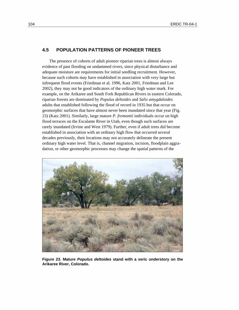
104 ERDC TR-04-1
4.5 POPULATION PATTERNS OF PIONEER TREES
The presence of cohorts of adult pioneer riparian trees is almost always evidence of past flooding on undammed rivers, since physical disturbance and adequate moisture are requirements for initial seedling recruitment. However, because such cohorts may have established in association with very large but infrequent flood events (Friedman et al. 1996, Katz 2001, Friedman and Lee 2002), they may not be good indicators of the ordinary high water mark. For example, on the Arikaree and South Fork Republican Rivers in eastern Colorado, riparian forests are dominated by Populus deltoides and Salix amygdaloides adults that established following the flood of record in 1935 but that occur on geomorphic surfaces that have almost never been inundated since that year (Fig. 23) (Katz 2001). Similarly, large mature P. fremontii individuals occur on high flood terraces on the Escalante River in Utah, even though such surfaces are rarely inundated (Irvine and West 1979). Further, even if adult trees did become established in association with an ordinary high flow that occurred several decades previously, their locations may not accurately delineate the present ordinary high water level. That is, channel migration, incision, floodplain aggra-dation, or other geomorphic processes may change the spatial patterns of the
Figure 23. Mature Populus deltoides stand with a xeric understory on the Arikaree River, Colorado.
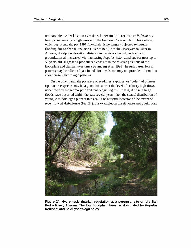
Chapter 4. Vegetation 105
ordinary high water location over time. For example, large mature P. fremontii trees persist on a 3-m-high terrace on the Fremont River in Utah. This surface, which represents the pre-1896 floodplain, is no longer subjected to regular flooding due to channel incision (Everitt 1995). On the Hassayampa River in Arizona, floodplain elevation, distance to the river channel, and depth to groundwater all increased with increasing Populus-Salix stand age for trees up to 50 years old, suggesting pronounced changes in the relative positions of the floodplain and channel over time (Stromberg et al. 1991). In such cases, forest patterns may be relicts of past inundation levels and may not provide information about present hydrologic patterns.
On the other hand, the presence of seedlings, saplings, or “poles” of pioneer riparian tree species may be a good indicator of the level of ordinary high flows under the present geomorphic and hydrologic regime. That is, if no rare large floods have occurred within the past several years, then the spatial distribution of young to middle-aged pioneer trees could be a useful indicator of the extent of recent fluvial disturbance (Fig. 24). For example, on the Arikaree and South Fork
Figure 24. Hydromesic riparian vegetation at a perennial site on the San Pedro River, Arizona. The low floodplain forest is dominated by Populus fremontii and Salix gooddingii poles.
106 ERDC TR-04-1
Republican Rivers in eastern Colorado, seedlings and juveniles of Populus deltoides and Salix amygdaloides were almost entirely confined to the active fluvial zone, although adults occurred over a much larger area (Katz 2001). Similarly, on the Hassayampa River in Arizona, young (10-year-old) Populus and Salix cohorts occurred close to the river channel, while older cohorts occurred farther away and at higher floodplain elevations (Stromberg et al. 1991).
Although the presence of woody riparian pioneer seedlings and saplings may be a good indicator of recent fluvial disturbance, their absence at a given location in the riparian zone does not necessarily indicate a lack of high flow. Seed germination and seedling establishment may be prevented by a variety of factors, even within a regularly flooded zone. The relative timing of high flows and seed dispersal may result in an absence of seedlings. That is, if peak flows occur earlier or later than the period of seed release for a given riparian species, dispersed seeds may not encounter suitable seed beds and germination will not occur. Even if high flows do coincide with seed dispersal, the shape of the flood hydrograph may preclude seedling establishment. Specifically, for optimal seedling establishment of riparian Populus species, flow discharge will decline gradually after seed germination in order for seedling roots to remain in contact with the receding moisture zone (Mahoney and Rood 1998). Seed germination and seedling establishment may also be prevented by factors such as temperature, substrate pH, and salinity (Siegel and Brock 1990, Shafroth et al. 1995b).
Seedlings that do become established in association with ordinary high flows generally experience high mortality rates. In arid-region riparian environments, a primary cause of seedling mortality is a lack of available moisture to plant roots. Although drought-intolerant seedlings of riparian pioneer species may become established and survive for a short period following flooding or a precipitation event, survival is unlikely if soil moisture levels are low and alluvial groundwater levels are out of reach of plant roots. For example, first-year seedlings of Salix lasiolepis on Schultz Creek in northern Arizona experienced close to 100% mortality, primarily as a result of desiccation during the summer months (Sacchi and Price 1992). Similarly, 75% of 37,000 first-year P. wrightii seedlings censused in Lyle Canyon in southeastern Arizona in 1983 died from desiccation in their first summer (Bock and Bock 1989). After one to two years, Populus and Salix saplings are still vulnerable to desiccation, and mortality rates of 100% have been observed in response to groundwater decline (Shafroth et al. 2000).
At the other extreme, floods are an equally important mortality agent for riparian seedlings. In experimental studies, P. fremontii, S. gooddingii, P. sericea, and B. salicifolia have been shown to possess significant inundation tolerance, surviving saturated soil conditions for 58 days with no reductions in

Chapter 4. Vegetation 107
growth, while Tamarix was intolerant of this (Vandersande et al. 2001). However, flood-induced seedling mortality rates can be very high in natural settings. For example, P. fremontii, S. gooddingii, and T. chinensis seedlings that established following a 25-year flood on the Hassayampa River in Arizona had 96%, 96%, and 100% mortality following a 15- to 20-year flood that occurred two years later (Stromberg 1997). Flood-induced mortality is not restricted to seedlings; in 1981, a succession of two 35-year flash floods removed an entire cohort of 11-year-old P. wrightii saplings in Lyle Canyon in Arizona (Bock and Bock 1989).
Mechanisms associated with flood-induced mortality of riparian plants include the physical force of floodwaters (which results in stem breakage or mobilization of underlying sediments) and the physiological stress of prolonged inundation (Friedman and Auble 1999). Although often difficult to tease apart, these factors may operate alone or in tandem to reduce seedling numbers. For example, Acer negundo seedlings on the Gunnison River in Black Canyon of the Gunnison National Monument suffered significant mortality from extended inundation in 1995, though shear stress clearly influenced the spatial distribution of older individuals, with no established trees having survived shear stresses that exceeded the critical shear stress by more than 24 Pa (Friedman and Auble 1999). Burial effects may also be important, though many riparian species appear to be fairly tolerant of sediment deposition (e.g., P. fremontii, S. gooddingii, and T. ramosissima seedlings) (Levine and Stromberg 2001).
108 ERDC TR-04-1
4.6 HERBACEOUS PLANT PATTERNS
Compared to woody species, herbaceous riparian species have received considerably less research attention, especially with regard to the effects of surface streamflow on plant patterns and dynamics. However, because herba-ceous plants generally live for much shorter lengths of time than woody plants, herbaceous vegetation patterns may be more likely to reflect present (or recent) ecological conditions. Therefore, to the extent that herbaceous vegetation patterns in riparian systems reflect characteristics of surface flow, they have the potential to be useful indicators of recent inundation levels. Several studies have noted that individual herbaceous plant species tend to occur in specific locations or within particular “patch types” within the riparian zone. For example, species such as Nasturtium officinale (water cress) and Veronica anagallis-aquatica (water speedwell) are common in wet, stream-edge habitats in central and south-ern Arizona, while within-channel sandbars are more commonly dominated by Polypogon monspeliensis (rabbit’s foot grass) and stream banks are often domi-nated by Cynodon dactylon (bermuda grass) and Melilotus albus (sweet clover) (Stromberg and Chew 1997, Stromberg et al. 1997b). Vegetation patch types that occur on higher alluvial surfaces, such as P. velutina woodlands and P. fremontii-S. gooddingii forests, usually support a different suite of herbaceous species (Stromberg et al. 1991, 1997b, Stromberg and Chew 1997). If such patterns could be related to specific streamflow characteristics, herbaceous plant distributions might be a reliable indicator of the ordinary high water level.
Although it is probably not realistic to document the inundation tolerances or responses of all herbaceous species present at a particular riparian site, the classi-fication of plant species into functional groups that share ecological traits and tolerances is a useful approach in this context (Stromberg et al. 1996, Stromberg and Bagstad, in prep). Ecological characteristics of herbaceous plants that have been identified as important in riparian systems include longevity (annual, biennial, perennial), growth form (rhizomatous, caespitose, taprooted), reproduc-tive mode (sexual vs. asexual), and competitive ability (Friedman et al. 1996, Stromberg et al. 1996, 1997b, Stromberg and Bagstad, in prep). Wetland indica-tor classes can also be used to designate plant functional groups (Reed 1988, Stromberg and Bagstad, in prep). The five recognized wetland indicator classes are based on the probability of species occurrence in wetlands and include Obligate Wetland (>99% frequency of occurrence in wetlands), Facultative Wetland (67–99%), Facultative (34–66%), Facultative Upland (1–33%), and Obligate Upland (<1%). Plant rankings are adjusted for different geographic regions and can be determined by accessing the U.S. Fish and Wildlife Service

Chapter 4. Vegetation 109
web page or the USDA-NRCS Plant Database (Reed 1988, USDA-NRCS 2001, USFWS 2003). While these classes do not isolate the effect of flooding per se, in arid regions they do indicate the overall reliance of a species on supplemental moisture, which is likely to be well correlated with surface flow characteristics.
If riparian plants are classified into functional groups based on traits that reflect adaptation to flooding, the spatial distributions of such functional groups on a given floodplain might be helpful for identifying recent high water levels. For example, “hydromesic ruderals” (e.g., Xanthium strumarium, Polygonum lapathifolium, Polypogon monspeliensus) are disturbance-adapted herbaceous plants with relatively high moisture requirements that occur in riparian zones in Arizona (Stromberg and Bagstad, in prep). Such plants, by definition, are annuals or biennials with wetland indicator classifications of Obligate Wetland through Facultative Upland, meaning that they require more moisture than is normally provided by direct precipitation. The zone of dominance of hydromesic ruderals on the floodplain might therefore be indicative of the zone of regular flooding, while the point at which herbaceous dominance shifts to more xeric ruderals (e.g., Acalypha neomexicana, Bouteloua aristidoides, Sisymbrium irio) might indicate the limit of the regularly flooded zone (Fig. 25) (Stromberg and Bagstad, in prep)*. For perennial herbs, dominance by hydromesic rhizomatous or stoloniferous species (e.g., Paspalum distichum, Cynodon dacytlon) may be indicative of the zone of regular fluvial disturbance, since clonally reproducing plants may readily recolonize floodplain sites following flood disturbance (Stromberg 1993c) and may be better adapted to persist in the shade of young, dense cottonwood stands (Friedman et al. 1996). Of course, such relationships would need to be fine-tuned in order for such patterns to be used reliably as indicators of specific levels of surface flow, and additional research into the actual water sources (e.g., precipitation, surface flow, groundwater) used by specific herbaceous plant species would be needed.
* Also personal communication, J. Stromberg.
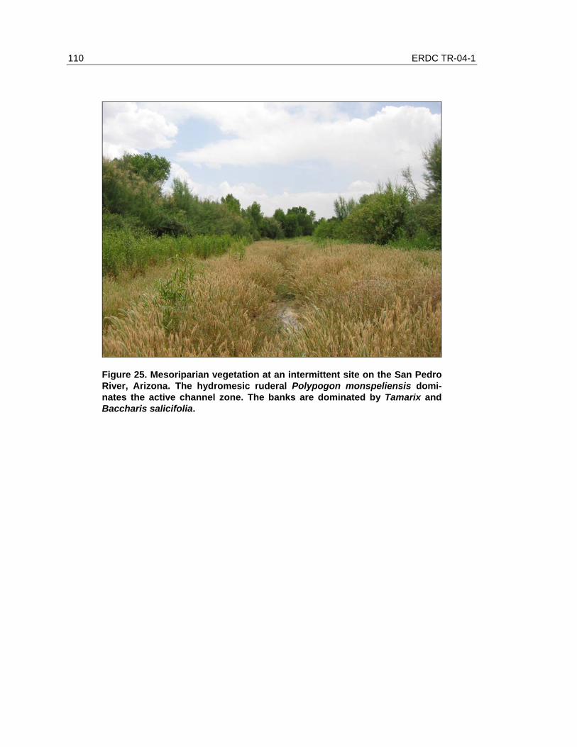
110 ERDC TR-04-1
Figure 25. Mesoriparian vegetation at an intermittent site on the San Pedro River, Arizona. The hydromesic ruderal Polypogon monspeliensis domi-nates the active channel zone. The banks are dominated by Tamarix and Baccharis salicifolia.

Chapter 4. Vegetation 111
4.7 XERORIPARIAN SYSTEMS
By far, most research on riparian ecosystems in the southwest has focused on those relatively hydric or mesic wetlands that occur on perennial and intermittent streams. Such hydroriparian and mesoriparian systems are characterized by sufficient moisture to support pioneer riparian trees or shrubs and hydromesic herbaceous species. However, most watercourses in the arid southwest are ephemeral and support a suite of xeroriparian species whose ecology and hydrologic relations are poorly understood (Fig. 26). Xeroriparian systems occur on streams that flow infrequently and where the water table is usually too deep to be accessible to plant roots. However, minor amounts of infrequently delivered supplemental moisture can produce detectable vegetation patterns on small ephemeral streams. Even slightly augmented moisture may allow for greater overall vegetation volume, height, or stem density compared to upland areas and/or the occurrence of unique xeroriparian species that are not present in uplands. Studies of xeroriparian vegetation are complicated by the fact that many species, including some community dominants, occur in both riparian and
Figure 26. Xeroriparian vegetation along a wash near Tucson, Arizona. The dominant plants are Prosopis velutina, Celtis pallida, and mixed cacti.

112 ERDC TR-04-1
adjacent upland habitats (Bloss and Brotherson 1979, Warren and Anderson 1985, Leitner 1987, McArthur and Sanderson 1991), by the subtle effects of small changes in hydrologic conditions on plant distribution patterns or vegetation structure in and along dry stream channels, and by the scarcity of hydrologic data (e.g., gauge records) for small ephemeral streams.
Despite these difficulties a few published studies have identified distinct plant occurrence patterns in xeroriparian settings. Warren and Anderson (1985) found that plant distributions varied with drainage area along desert washes dissecting bajadas in Organ Pipe National Monument in Arizona. Certain species (e.g., Cercidium microphyllum) tended to occur both in smaller washes and in uplands, while others occurred only in medium-sized (e.g., Ephedra nevadensis, Celtis pallida, Zizyphus obtusifolia) or large (e.g., Baccharis sarothroides, Hymenoclea salsola) washes and not in uplands. Hupp and Osterkamp (1996) present similar data for the same geographic area. They report that on the smallest washes, upland plants (Ambrosia deltoidea, Larrea tridentata) occur on lower, middle, and upper parts of banks. Larger and wetter washes may support less-xeric species (e.g., Chilopsis linearis, Acacia greggii) on the lower parts of banks but upland species on the upper banks. However, larger and drier washes do not support these species, instead supporting plants with apparently lower moisture requirements (e.g., Acacia constricta) (Hupp and Osterkamp 1996). In a study of bajada vegetation in southwestern Utah, McArthur and Sanderson (1991) identified 14 species that tended to occur preferentially in small channels dissecting the slope surface (e.g., Chyrsothamnus paniculatus, Encelia frutescens, Gutierrezia microcephala), 3 that tended to occur in upland areas (Acamptopappus sphaerocephalus, Krameria parviflora, Larrea tridentata), and 13 that exhibited no distributional tendency (e.g., Yucca brevifolia, Ambrosia dumosa, Ephedra nevadensis, Lycium andersonii, Opuntia spp.).
While these studies provide important information about xeroriparian systems, they do not explicitly address the relationships between species distributions and surface flow characteristics. That is, there appear to be no published studies addressing the role of specific surface flows in influencing the reproduction, growth, survival, or spatial distributions of xeroriparian species. Although xeroriparian vegetation patterns likely reflect surface flow patterns quite strongly because of the inaccessibility of the water table at most xeroriparian sites, we do not know which kinds of surface flows (e.g., in terms of magnitude, frequency, stream power, geomorphic effectiveness, etc.) have the most pronounced impact. Without further research it may be difficult to use xeroriparian vegetation patterns as evidence for the ordinary high water mark on ephemeral streams.

Chapter 4. Vegetation 113
4.8 INDIVIDUAL RESPONSE
Floods may produce both positive and negative effects on established plants. Positive effects of floods on arid-region riparian trees include higher growth rates and greater foliage area, stem basal area, and riparian forest patch width on rivers with higher flow volume (Stromberg 1993b, 2001b). These effects result primarily from augmented floodplain moisture levels produced by flood-induced replenishment of shallow alluvial aquifers, and possibly from the fertilization effects of sediment-laden flows (Stromberg 2001b). Floodwaters may also flush salts from floodplain soils, resulting in more favorable growing conditions for some species (Vandersande et al. 2001). Although growth rate may be a reliable indicator of flow volume at a site and may integrate hydrology over several years (which may be beneficial for the present purpose), it is unlikely to be a useful field indicator of ordinary high water, since within-site variations may not be detectable, and it is not easily measured during a single field visit.
The damaging effects of flood flows on established individuals include death and wholesale removal, or lesser impacts such as flood-training, burial, breakage, and abrasion. Large floods may scour riparian forests. For example, a large flood removed most of the riparian forest on Plum Creek in Colorado in 1965 (Friedman et al. 1996). Flooding on the Hassayampa River in Arizona removed 30% of the Populus-Salix forest, 35% of the Prosopis woodland, and 90% of the B. salicifolia shrub vegetation in 1993 (Stromberg et al. 1997a). Following non-lethal flood dam-age, many riparian plants sprout vigorously from stem bases or prostrated stems left in situ. Shrub species such as B. salicifolia are especially adept at this mode of recov-ery (Stromberg et al. 1997a). Often, the effects of past flooding are not visible at the ground surface, but excavation of tree and shrub stems will reveal repeated episodes of flood-induced prostration, burial by sediment, and resprouting (Everitt 1968).
There are several sources of visible evidence of recent flooding that could be used to help identify recent high flow levels. First, when floodwaters carry debris that can abrade standing stems, flood scars are often produced. Such scars will eventually “heal” and become covered by bark, making them visible only in stem cross-sections. However, if flooding has been recent, flood scars will still be visible and can provide an indication of the height of floodwaters and the spatial extent of inundation on the floodplain. Flood debris deposits can also provide evidence of the spatial occurrence of past flood flows. In general, larger floods will carry and deposit larger kinds of debris, such as whole trees, and such debris will persist for relatively long periods on the floodplain. Smaller flows will carry and deposit finer kinds of debris, including leaves and twigs, which persist for shorter periods of time following deposition.

114 ERDC TR-04-1
4.9 IDENTIFYING THE ORDINARY HIGH WATER MARK: SUMMARY AND SYNTHESIS
Because of the close association between riparian vegetation and stream hydrology, there is considerable potential for using vegetation patterns to assist in identifying the ordinary high water mark in the arid Southwest. To this end, vegetative evidence can be considered for two cases: evidence of locations below the OHWM (Table 13) and evidence of locations above the OHWM or outside of the OHW zone (Table 14).
Several points become clear upon examination of these tables. First, the ecology of some riparian systems is not well understood, and these systems are therefore under-represented. In particular, very little has been published on xeroriparian systems, yielding only speculative entries in the tables. More information regarding the role of streamflow in influencing spatial and temporal patterns of xeroriparian species is needed before the observed patterns can be reliably used to indicate specific levels of surface flow. Also, mid- to high-elevation mixed deciduous forests have not been nearly as well studied as have the lower-elevation Populus-, Salix-, and Tamarix-dominated systems. While the higher-elevation riparian forests contain pioneer tree species (i.e. Populus, Salix, Platanus) whose ecology is relatively well understood, they also contain a variety of seral species with different life history traits and environmental tolerances. Efforts to understand the role of hydrology in influencing rates and patterns of ecological succession in these systems would provide helpful information for delineating areas beyond the ordinary high water level.
Second, many of the lines of evidence listed in the tables may be applicable beyond the specific settings addressed in the published examples. For example, fluvial marsh taxa should indicate locations below the OHWM in high-elevation systems, as well as in the low-elevation systems for which examples are provided. For each potential indicator listed, the likely elevation range (mid- to high elevation, low elevation) and riparian moisture type (Hydro-mesic riparian, Mesoriparian, Xeroriparian) for which it is applicable is provided. For cases where published examples are not listed, the potential indicators should be care-fully tested.
Third, although analysis of the current scientific literature provides several potential vegetation indicators of the OHWM, in many (or most) cases this was not the purpose of the original research. Therefore, the use of specific indicators based on a single published source is probably not advisable. Rather, these findings should be taken as suggestions regarding the types of patterns that could

Chapter 4. Vegetation 115
Table 13. Potential vegetative evidence of location below the ordinary high water mark. Selected examples
Indicator* Elev. Rip. Type Representative taxa River Source
L HM Phragmites australis, Juncus spp., Carex spp.,
Colorado River, AZ
Stevens et al. (1995)
L HM J. arcticus, Eleocharis palustris
Green River, CO
Merritt and Cooper (2000)
L HM E. palustris, Agrostis stolon-ifera, Euthamia occidentalis
Gunnison River, CO
Auble et al. (1994)
L HM Veronica anagallis-aquatica, Eragrostis pectinata
Plum Creek, CO
Friedman et al. (1996)
Herbaceous plants: emergent or fluvial marsh taxa (All, HM)
L HM Scripus americanus, Paspalum distichum
Hassayampa River, AZ
Stromberg et al. (1997a)
Annual herbs: Hydromesic ruderals dominant (All, HM)
L HM Xanthium strumarium, Polypogon monspeliensis
San Pedro, AZ
Stromberg (unpub. data)
L HM Poa pratensis, Aster hesperius, Carex spp., Juncus balticus, Equisetum spp.
Plum Creek, CO
Friedman et al. (1996)
Perennial herbs: Hydromesic clonal plants dominant (All, HM) L HM Cynodon dactylon, Paspalum
distichum Hassayampa River, AZ
Stromberg et al. (1993c)
H HM P. wrightii Various, AZ Stromberg (2001a)
Pioneer tree seedlings within active channel (All, HM) L HM Populus, Salix, Tamarix Green River,
CO Merritt and Cooper (2000)
Pioneer tree seedlings above/beyond active channel (e.g., on floodplain, overflow channels) (All, HM-M)
L HM P. fremontii and S. gooddingii seedlings
Hassayampa River, AZ
Stromberg et al. (1993c)
H HM Populus, Salix, Platanus spp. -- L HM P. fremontii, S. gooddingii
saplings Hassayampa River, AZ
Stromberg et al. (1991)
Pioneer tree saplings and/or poles, on surfaces without mature individuals (All, HM-M) L HM P. fremontii, S. exigua,
Tamarix saplings Escalante River, UT
Irvine and West (1979)
Bare mineral substrate, sparse vegetation (All, M-X)
L M Low herbaceous cover S. Fk. Republi-can & Arikaree Rivers, CO
Katz (2001)
L X Acacia constricta, A. greggii, Baccharis sarothroides, Hymenoclea salsola
Sonoran desert washes
Warren and Anderson (1985)
Xeroriparian species dominant(?) (All, X)
L X Chrysothamnus paniculatus, Gutierrezia microcephala, H. salsola
Mojave desert washes
McArthur and Sanderson (1991)
L = mid-low elevation, H = high-mid elevation, HM = hydro-mesic riparian, M = mesoriparian, X = xeroriparian. * Parentheses indicate (elevation, riparian moisture type) in which the indicator is likely to be applicable.

116 ERDC TR-04-1
Table 14. Possible vegetative evidence of location above the ordinary high water mark.
Selected examples Indicator* Elev.
Rip. Type Representative taxa River Source
L HM Berteroa incana, Bromus tectorum, etc.
Plum Creek, CO
Friedman et al. (1996)
Annual herbs: Xeric ruderals dominant (L, All) L HM B. tectorum Gunnison
River, CO Auble et al. (1994)
Perennial herbs: Clonal and non-clonal species co-dominant (All, HM)
L HM Sporobolis cryptandrus, Heterotheca villosa, Agropyron spp.
Plum Creek, CO
Friedman et al. (1996)
Perennial herbs: Non-clonal species dominant (All, HM)
L HM S. cryptandrus, H. villosa, Gunnison River, CO
Auble et al. (1994)
L HM P. deltoides S. Fk. Republican and Arikaree Rivers, CO
Katz (2001) Mature pioneer trees on surfaces without younger cohorts (All, HM-M)
L HM P. fremontii, S. exigua, Tamarix
Escalante River, UT
Irvine and West (1979)
Mature pioneer trees with xeric understory species (L, HM-M)
L HM P. deltoides overstory with Chrysothamnus viscidiflorus, Sarcobatus vermiculatus, B. tectorum, Sporobolis airoides
Green River, CO
Merritt and Cooper (2000)
L HM Populus spp. with Prunus virginiana, Cretaegus spp.
Plum Creek, CO
Friedman et al. (1996)
Mature pioneer trees with seral or upland species (All, HM-M) L HM P. fremontii with Atriplex
canescens, S. vermiculatus Fremont River, UT
Everitt (1995)
Late-successional species composition (H, HM-M)
H HM Acer negundo, Abies concolor, A. galbrum, A. grandidentatum, Mahonia repens
Various, ZNP, Utah
Harper et al. (1991)
L X Fouquieria splendens, Fagonia californica, Olneya tesota
unnamed canyon arroyo, Sonora, MX
Leitner (1987)
L X F. splendens, Opuntia fulgida, Echinocereus engelmannii
New River, AZ Bloss and Brotherson (1979)
Upland species dominant (All, All)
L X Acamptopappus sphaerocephalus, Krameria parviflora, L. tridentata
Beaver Dam Slope, UT
McArthur and Sanderson (1991)
L = mid-low elevation, H = high-mid elevation, HM = hydro-mesic riparian, M = mesoriparian, X = xeroriparian. * Parentheses indicate (elevation, riparian moisture type) in which the indicator is likely to be applicable.

Chapter 4. Vegetation 117
be further studied and developed into reliable indicators of the ordinary high water mark.
Finally, examination of multiple vegetation indicators may be the best way to use vegetative evidence in attempts to delineate the OHWM in the field. That is, not all types of evidence may exist at all sites, making reliance on a single attrib-ute problematic. Or vegetation patterns may be somewhat subtle or diffuse, making clear demarcation of the ordinary high water line difficult. If field inves-tigators assess the preponderance of the evidence, rather than looking for single specific indicators, a stronger OHW signal will likely be detected.

118 ERDC TR-04-1
4.10 CONCLUSION
Riparian vegetation is strongly influenced by fluvial processes. For many species, key ecological processes depend on the hydrologic conditions and geo-morphic changes associated with floods, and this dependence leads to vegetation establishment patterns that may be useful in identifying the level of ordinary high water. However, straightforward equilibrium interpretations of the relationship between arid-region riparian vegetation assemblages and specific flood regimes are only appropriate in certain settings. In particular, such interpretations are potentially most useful for explaining the distributions of herbaceous species, and possibly short-lived shrubs, on perennial rivers in arid regions (Auble et al. 1994, Stevens et al. 1995). On intermittent and ephemeral streams, flooding may be very infrequent, leading to non-equilibrium relationships between vegetation patterns (particularly spatial distributions of long-lived trees) and surface flow conditions. In these situations, which comprise the majority of arid-region riparian zones, vegetation patterns may constitute evidence of past, but not present, hydrologic conditions or may most strongly reflect the influence of sub-surface hydrology or other factors.
We can conduct successful hydrogeomorphic interpretations of arid-region riparian vegetation patterns if we are careful to consider site history and patterns of change over time. In the absence of extreme flooding within the last decade, the distributions of seedlings, saplings, and poles of pioneer riparian trees may be useful in determining the location of the ordinary high water level. In addition, herbaceous plant distributions may be useful in this regard, since the distributions of short-lived species can be expected to reflect recent ecological conditions. The spatial distributions of disturbance-adapted species with high moisture require-ments may indicate the extent of recent fluvial disturbance, though more research is needed on this topic. Finally, the distributional limits of upland plant species that do not tolerate flood disturbance may provide some indication of the location of the zone beyond the ordinary high water level.

Chapter 4. Vegetation 119
4.11 REFERENCES
Auble, G.T., and M.L. Scott (1998) Fluvial disturbance patches and cottonwood recruitment along the upper Missouri River, Montana. Wetlands, 18: 546–556.
Auble, G.T., J.M. Friedman, and M.L. Scott (1994) Relating riparian vegeta-tion to present and future streamflows. Ecological Applications, 4: 544–554.
Belsky, A.J., A. Matzke, and S. Uselman (1999) Survey of livestock influences on stream and riparian ecosystems in the western United States. Journal of Soil and Water Conservation, 54: 419–431.
Bendix, J. (1994) Among-site variation in riparian vegetation of the southern California transverse ranges. American Midland Naturalist, 132: 136–151.
Bendix, J. (1999) Stream power influence on southern Californian riparian vegetation. Journal of Vegetation Science, 10: 243–252.
Bloss, D.A., and J.D. Brotherson (1979) Vegetation response to a moisture gradient on an ephemeral stream in central Arizona. Great Basin Naturalist, 39: 161–176.
Bock, J.H., and C.E. Bock (1989) Factors limiting sexual reproduction in Platanus wrightii in southeastern Arizona. ALISO, 12: 295–301.
Braatne, J.H., S.B. Rood, and P.E. Heilman (1996) Life history, ecology, and conservation of riparian cottonwoods in North America. In Biology of Populus and its Implications for Management and Conservation (R.F. Stettler, H.D. Bradshaw Jr., P.E. Heilman, and T.M. Hinckley, ed.). Ottawa: NRC Research Press, p. 57–85.
Bradley, C.E., and D.G. Smith (1986) Plains cottonwood recruitment and survival on a prairie meandering river floodplain, Milk River, southern Alberta and northern Montana. Canadian Journal of Botany, 64: 1433–1442.
Brock, J.H. (1994) Tamarix spp. (salt cedar), an invasive exotic woody plant in arid and semi-arid riparian habitats of western U.S.A. In Ecology and Management of Invasive Riverside Plants (L.C. de Waal, L.E. Child, P.M. Wade, and J.H. Brock, ed.). New York: Wiley, p. 27–44.
Busch, D.E. (1995) Effects of fire on southwestern riparian plant community structure. The Southwestern Naturalist, 40: 259–267.
Busch, D.E., and S.D. Smith (1995) Mechanisms associated with decline of woody species in riparian ecosystems of southwestern U.S. Ecological Monographs, 65: 347–370.

120 ERDC TR-04-1
Busch, D.E., N.L. Ingraham, and S.D. Smith (1992) Water uptake in woody riparian phreatophytes of the southwestern United States: A stable isotope study. Ecological Applications, 2: 450–459.
Cooper, D.J., D.C. Anderson, and R.A. Chimner (2003) Multiple pathways for woody plant establishment on floodplains at local to regional scales. Journal of Vegetation Science, 91: 182–196.
Durkin, P., E. Muldavin, M. Bradley, and S. Carr (1995) A preliminary riparian/wetland classification of the Upper and Middle Rio Grande watersheds in New Mexico. In Desired Future Conditions for Southwestern Riparian Ecosystems: Bringing Interests and Concerns Together (D.W. Shaw and D.M Finch, ed.). Albuquerque, New Mexico: U.S. Dept of Agriculture, Forest Service, Rocky Mountain Forest and Range Experiment Station, p. 44–57.
Evans, J.M. (2001) Vegetation in watercourses of the eastern Mojave Desert. Fremontia, 29: 26–35.
Everitt, B.L. (1968) Use of the cottonwood in an investigation of the recent history of a flood plain. American Journal of Science, 266: 417–439.
Everitt, B.L. (1995) Hydrologic factors in regeneration of Fremont cottonwood along the Fremont River, Utah. In Natural and Anthropogenic Influences in Fluvial Geomorphology (J.E. Costa, A.J. Miller, K.W. Potter, and P.R. Wilcock, ed.). Washington, D.C.: American Geophysical Union, p. 197–208.
Everitt, B.L. (1998) Chronology of the spread of tamarisk in the central Rio Grande. Wetlands, 18: 658–668.
Fenner, P., W.W. Brady, and D.R. Patton (1985) Effects of regulated water flows on regeneration of Fremont cottonwood. Journal of Range Management, 38: 135–138.
Friedman, J.M., and G.T. Auble (1999) Mortality of riparian box elder from sediment mobilization and extended inundation. Regulated Rivers: Research and Management, 15: 463–476.
Friedman, J.M., and G.T. Auble (2000) Floods, flood control, and bottomland vegetation. In Inland Flood Hazards: Human, Riparian, and Aquatic Communities (E.E. Wohl, ed.). Cambridge: Cambridge University Press, p. 219–237.
Friedman, J.M., and V.J. Lee (2002) Extreme floods, channel change and riparian forests along ephemeral streams. Ecological Applications, 72: 409–425.
Chapter 4. Vegetation 121
Friedman, J.M., M.L. Scott, and W.M. Lewis, Jr. (1995) Restoration of riparian forest using irrigation, artificial disturbance, and natural seedfall. Environmental Management, 19: 547–557.
Friedman, J.M., W.R. Osterkamp, and W.M.J. Lewis (1996) Channel narrowing and vegetation development following a Great-Plains flood. Ecology, 77: 2167–2181.
Friedman, J.M., M.L. Scott, and G.T. Auble (1997) Water management and cottonwood forest dynamics along prairie streams. In Ecology and Conservation of Great Plains Vertebrates (F.L. Knopf and F.B. Samson, ed.). New York: Springer-Verlag, p. 49–71.
Friedman, J.M., W.R. Osterkamp, M.L. Scott, and G.T. Auble (1998) Down-stream effects of dams on channel geometry and bottomland vegetation: Regional patterns in the Great Plains. Wetlands, 18: 619–633.
Galuska, D.M., and T.E. Kolb (2002) Tree growth and regeneration response to climate and stream flow in a species-rich southwestern riparian forest. Western North American Naturalist, 62: 256–279.
Harper, K.T., S.C. Sanderson, and E.D. McArthur (1991) Riparian ecology in Zion National Park, Utah. In Symposium on Ecology and Management of Riparian Shrub Communities, Sun Valley, Idaho (W.P. Clary, E.D. McArthur, D. Bedunah, and C.L. Wambolt, ed.). USDA Forest Service GTR INT-289, p. 32–42.
Harris, R.R., R.J. Risser, and C.A. Fox (1985) A method for evaluating streamflow discharge—Plant species occurrence patterns on headwater streams. In Riparian Ecosystems and their Management: Reconciling Conflicting Uses (R.J. Johnson, C.D. Ziebell, D.R. Patton, P.F. Ffolliott, and R.H. Hamre, ed.). Tucson, Arizona: USDA Forest Service, p. 87–90.
Hendrickson, D.A., and W.L. Minckley (1984) Cienegas—Vanishing climax communities of the American southwest. Desert Plants, 6: 130–175.
Horton, J.L., and J.L. Clark (2001) Water table decline alters growth and survival of Salix gooddingii and Tamarix chinensis seedlings. Forest Ecology and Management, 140: 239–247.
Horton, J.L., T.E. Kolb, and S.C. Hart (2001) Physiological response to groundwater depth varies among species and with river flow regulation. Ecological Applications, 11: 1046–1059.
Howe, W.H., and F.L. Knopf (1991) On the imminent decline of Rio Grande cottonwoods in central New Mexico. The Southwestern Naturalist, 36: 218–224.

122 ERDC TR-04-1
Hupp, C.R., and W.R. Osterkamp (1985) Bottomland vegetation distribution along Passage Creek, Virginia in relation to fluvial landforms. Ecology, 66: 670–681.
Hupp, C.R., and W.R. Osterkamp (1996) Riparian vegetation and fluvial geomorphic processes. Geomorphology, 14: 277–295.
Irvine, J.R., and N.E. West (1979) Riparian tree species distribution and succession along the lower Escalante River, Utah. Southwestern Naturalist, 24: 331–346.
Johnson, R.R., S.W. Carothers, and J.M. Simpson (1984) A riparian classification system. In California Riparian Systems: Ecology, Conservation, and Productive Management (R.E. Warner and K.M. Hendrix, ed.). Berkeley: University of California Press, p. 375–382.
Johnson, W.C. (1994) Woodland expansion in the Platte River, Nebraska: Patterns and causes. Ecological Monographs, 64: 45–84.
Johnson, W.C., R.L. Burgess, and W.R. Keammerer (1976) Forest overstory vegetation and environment on the Missouri River floodplain in North Dakota. Ecological Monographs, 46: 59–84.
Karrenberg, S., P.J. Edwards, and J. Kollmann (2002) The life history of Salicaceae living in the active zone of floodplains. Freshwater Biology, 47: 733–748.
Katz, G.L. (2001) Fluvial disturbance, flood control, and biological invasion in Great Plains riparian forests. PhD thesis, University of Colorado, Boulder, Colorado.
Katz, G.L., J.M. Friedman, and S.W. Beatty (2001) Effects of physical disturbance and granivory on establishment native and alien riparian trees in Colorado, U.S.A. Diversity and Distributions, 7: 1–14.
Kozlowski, T.T. (2002) Physiological-ecological impacts of flooding on riparian forest ecosystems. Wetlands, 22: 550–561.
Leitner, L.A. (1987) Plant communities of a large arroyo at Punta Cirio, Sonora. Southwestern Naturalist, 32: 21–28.
Levine, C.M., and J.C. Stromberg (2001) Effects of flooding on native and exotic plant seedlings: Implications for restoring south-western riparian forests by manipulating water and sediment flows. Journal of Arid Environments, 49: 111–131.
Mahoney, J.M., and S.B. Rood (1998) Streamflow requirements for cotton-wood seedling recruitment—An integrative model. Wetlands, 18: 634–645.

Chapter 4. Vegetation 123
Malanson, G.P. (1993) Riparian Landscapes. Cambridge: Cambridge University Press.
McArthur, E.D., and S.C. Sanderson (1991) A comparison between xero- riparian and upland vegetation of Beaver Dam Slope, Utah, as desert tortoise habitat. In Symposium on Ecology and Management of Riparian Shrub Communities, Sun Valley, Idaho (W.P. Clary, E.D. McArthur, D. Bedunah, and C.L. Wambolt, ed.). USDA Forest Service, p. 25–31.
Merritt, D.M., and D.J. Cooper (2000) Riparian vegetation and channel change in response to river regulation: A comparative study of regulated and unregulated streams in the Green River Basin, USA. Regulated Rivers: Research and Management, 16: 543–564.
Minckley, W.L., and D.E. Brown (1994) Wetlands. In Biotic Communities: Southwestern United States and Northwestern Mexico (D.E. Brown, ed.). Salt Lake City: University of Utah Press, p. 223–287.
Nadler, C.T., and S.A. Schumm (1981) Metamorphosis of South Platte and Arkansas Rivers, eastern Colorado. Physical Geography, 2: 95–115.
Naiman, R.J., H. Decamps, and M. Pollock (1993) The role of riparian corridors in maintaining regional biodiversity. Ecological Applications, 3: 209–212.
Nanson, G.C. (1986) Episodes of vertical accretion and catastrophic stripping: A model of disequilibrium flood-plain development. Geological Society of America Bulletin, 97: 1467–1475.
Nanson, G.C., and H.F. Beach (1977) Forest succession and sedimentation on a meandering-river floodplain, northeast British Columbia, Canada. Journal of Biogeography, 4: 229–251.
Patten, D.T. (1998) Riparian ecosystems of semi-arid North America: Diversity and human impacts. Wetlands, 18: 498–512.
Poff, N.L., J.D. Allan, M.B. Bain, J.R. Karr, K.L. Prestegaard, B.D. Richter, R.E. Sparks, and J.C. Stromberg (1997) The natural flow regime: A paradigm for river conservation and restoration. BioScience, 47: 769–784.
Reed, Jr., P.B. (1988) National list of plant species that occur in wetlands: Southwest (region 7). Biological Report 88(26.7), U.S. Fish and Wildlife Service.
Reily, P.W., and W.C. Johnson (1982) The effects of altered hydrologic regime on tree growth along the Missouri River in North Dakota. Canadian Journal of Botany, 60: 2410–2423.

124 ERDC TR-04-1
Rood, S.B., A.R. Kalischuk, and J.M. Mahoney (1998) Initial cottonwood seedling recruitment following the flood of the century of the Oldman River, Alberta, Canada. Wetlands, 18: 557–570.
Russell, W.H., J.R. McBride, and K. Carnell (2003) Influence of environ-mental factors on the regeneration of hardwood species on three streams in the Sierra Nevada. Madrono, 50: 21–27.
Sacchi, C.F., and P.W. Price (1992) The relative roles of abiotic and biotic factors in seedling demography of Arroyo willow (Salix lasiolepis: Salicaceae). American Journal of Botany, 79: 395–405.
Schumm, S.A., and R.W. Lichty (1963) Channel widening and flood-plain construction along the Cimarron River in southwestern Kansas. Professional Paper 352-D, U.S. Geological Survey, Washington, D.C.
Scott, M.L., J.M. Friedman, and G.T. Auble (1996) Fluvial process and the establishment of bottomland trees. Geomorphology, 14: 327–339.
Scott, M.L., G.T. Auble, and J.M. Friedman (1997) Flood dependency of cottonwood establishment along the Missouri River, Montana, USA. Ecological Applications, 7: 677–690.
Scott, M.L., P.B. Shafroth, and G.T. Auble (1999) Responses of riparian cottonwoods to alluvial water-table declines. Environmental Management, 23: 347–358.
Segelquist, C.A., M.L. Scott, and G.T. Auble (1993) Establishment of Populus deltoides under simulated alluvial groundwater declines. American Midland Naturalist, 130: 274–285.
Shafroth, P.B., G.T. Auble, and M.L. Scott (1995a) Germination and establishment of native plains cottonwood (Populus deltoides Marshall subsp. monilifera) and the exotic Russian-olive (Elaeagnus angustifolia). Conservation Biology, 9: 169–175.
Shafroth, P.B., J.M. Friedman, and L.S. Ischinger (1995b) Effects of salinity on establishment of Populus fremontii (cottonwood) and Tamarix ramosissima (saltcedar) in southwestern United States. Great Basin Naturalist, 55: 58–65.
Shafroth, P.B., G.T. Auble, J.C. Stromberg, and D.T. Patten (1998) Establishment of woody riparian vegetation in relation to annual patterns of streamflow, Bill Williams River, Arizona. Wetlands, 18: 577–590.
Shafroth, P.B., J.C. Stromberg, and D.T. Patten (2000) Woody riparian vegetation response to different alluvial water table regimes. Western North American Naturalist, 60: 66–76.
Chapter 4. Vegetation 125
Shafroth, P.B., J.C. Stromberg, and D.T. Patten (2002) Riparian vegetation response to altered disturbance and stress regimes. Ecological Applications, 12: 107–123.
Siegel, R.S., and J.H. Brock (1990) Germination requirements of key south-western woody riparian species. Desert Plants, 10: 3–34.
Snyder, K.A., and D.G. Williams (2000) Water sources used by riparian trees varies among stream types on the San Pedro River, Arizona. Agricultural and Forest Meteorology, 105: 227–240.
Stevens, L.E., J.C. Schmidt, T.J. Ayers, and B.T. Brown (1995) Flow regulation, geomorphology, and Colorado River marsh development in the Grand Canyon, Arizona. Ecological Applications, 5: 1025–1039.
Stromberg, J.C. (1993a) Fremont cottonwood–Goodding willow riparian forests: A review of their ecology, threats, and recovery potential. Journal of the Arizona–Nevada Academy of Science, 26: 97–110.
Stromberg, J.C. (1993b) Instream flow models for mixed deciduous riparian vegetation within a semiarid region. Regulated Rivers, 8: 225–235.
Stromberg, J.C. (1993c) Response of a Sonoran riparian forest to a 10-year return flood. Great Basin Naturalist, 53: 118–130.
Stromberg, J.C. (1993d) Riparian mesquite forests: A review of their ecology, threats, and recovery potential. Journal of the Arizona–Nevada Academy of Science, 27: 111–124.
Stromberg, J.C. (1997) Growth and survivorship of Fremont cottonwood, Goodding willow, and salt cedar seedlings after large floods in central Arizona. Great Basin Naturalist, 57: 198–208.
Stromberg, J. (1998) Dynamics of Fremont cottonwood (Populus fremontii) and saltcedar (Tamarix chinensis) populations along the San Pedro River, Arizona. Journal of Arid Environments, 40: 133–155.
Stromberg, J.C. (2001a) Biotic integrity of Platanus wrightii riparian forests in Arizona: First approximation. Forest Ecology and Management, 142: 251–266.
Stromberg, J.C. (2001b) Influence of stream flow regime and temperature on growth rate of the riparian tree, Platanus wrightii, in Arizona. Freshwater Biology, 46: 227–239.
Stromberg, J.C., and K.J. Bagstad (in prep.) Riparian plant functional group response to drought and flooding, San Pedro River, Arizona.

126 ERDC TR-04-1
Stromberg, J.C., and M.K. Chew (1997) Herbaceous exotics in Arizona’s riparian ecosystems. Desert Plants, 11–17.
Stromberg, J.C., and D.T. Patten (1990) Riparian vegetation instream flow requirements: A case study from a diverted stream in the eastern Sierra Nevada, California, USA. Environmental Management, 14: 185–194.
Stromberg, J.C., D.T. Patten, and B.D. Richter (1991) Flood flows and the dynamics of Sonoran riparian forests. Rivers, 2: 2221–2235.
Stromberg, J.C., S.D. Wilkens, and J.A. Tress (1993) Vegetation-hydrology models: Implications for management of Prosopis velutina (velvet mesquite) riparian ecosystems. Ecological Applications, 3: 307–314.
Stromberg, J.C., R. Tiller, and B.D. Richter (1996) Effects of groundwater decline on riparian vegetation of semiarid regions: The San Pedro, Arizona. Ecological Applications, 6: 113–131.
Stromberg, J.C., J. Fry, and D.T. Patten (1997a) Marsh development after large floods in an alluvial arid-land river. Wetlands, 17: 292–300.
Stromberg, J.C., L. Gengarelly, and B.F. Rogers (1997b) Exotic herbaceous species in Arizona’s riparian ecosystems. In Plant Invasions: Studies from North America and Europe (J.H. Brock, M. Wade, P. Pysek, and D. Green, ed.). Leiden, The Netherlands: Backhuys, p. 45–57.
Szaro, R.C. (1990) Southwestern riparian plant communities: Site characteris-tics, tree species distributions, and size-class structure. Forest Ecology and Man-agement, 33/34: 315–334.
USDA-NRCS (2001) The PLANTS Database, Version 3.1. National Plant Data Center.
USFWS (2003) National Wetlands Inventory: NWI Codes/ Definitions. http://www.nwi.fws.gov/atx/atx.html
Vandersande, M.W., E.P. Glenn, and J.L. Walworth (2001) Tolerance of five riparian plants from the lower Colorado River to salinity drought and inundation. Journal of Arid Environments, 49: 147–159.
Warren, D.K., and R.M. Turner (1975) Saltcedar (Tamarix chinensis) seed production, seedling establishment, and response to inundation. Journal of the Arizona Academy of Science, 10: 135–144.
Warren, P.L., and L.S. Anderson (1985) Gradient analysis of a Sonoran Desert wash. In Riparian Ecosystems and their Management: Reconciling Conflicting Uses (R.J. Johnson, C.D. Ziebell, D.R. Patton, P.F. Ffolliott, and R.H. Hamre, ed.). Tucson, Arizona: USDA Forest Service, p. 150–155.

Chapter 4. Vegetation 127
Young, J.A., and C.G. Young (1992) Seeds of Woody Plants in North America. Portland, Oregon: Discorides Press.

1. REPORT DATE (DD-MM-YY) 2. REPORT TYPE 3. DATES COVERED (From - To)
4. TITLE AND SUBTITLE 5a. CONTRACT NUMBER
5b. GRANT NUMBER
5c. PROGRAM ELEMENT NUMBER
6. AUTHOR(S) 5d. PROJECT NUMBER
5e. TASK NUMBER
5f. WORK UNIT NUMBER
7. PERFORMING ORGANIZATION NAME(S) AND ADDRESS(ES) 8. PERFORMING ORGANIZATION REPORT
9. SPONSORING/MONITORING AGENCY NAME(S) AND ADDRESS(ES) 10. SPONSOR / MONITOR’S ACRONYM(S)
11. SPONSOR / MONITOR’S REPORT NUMBER(S)
12. DISTRIBUTION / AVAILABILITY STATEMENT
13. SUPPLEMENTARY NOTES
14. ABSTRACT
15. SUBJECT TERMS
16. SECURITY CLASSIFICATION OF: 17. LIMITATION OF 18. NUMBER 19a. NAME OF RESPONSIBLE PERSONOF ABSTRACT OF PAGES
a. REPORT b. ABSTRACT c. THIS PAGE 19b. TELEPHONE NUMBER (include area code)
U U U U 138
REPORT DOCUMENTATION PAGEPublic reporting burden for this collection of information is estimated to average 1 hour per response, including the time for reviewing instructions, searching existing data sources, gathering and maintaining thedata needed, and completing and reviewing this collection of information. Send comments regarding this burden estimate or any other aspect of this collection of information, including suggestions for reducingthis burden to Department of Defense, Washington Headquarters Services, Directorate for Information Operations and Reports (0704-0188), 1215 Jefferson Davis Highway, Suite 1204, Arlington, VA 22202-4302.Respondents should be aware that notwithstanding any other provision of law, no person shall be subject to any penalty for failing to comply with a collection of information if it does not display a currently validOMB control number. PLEASE DO NOT RETURN YOUR FORM TO THE ABOVE ADDRESS.
Form ApprovedOMB No. 0704-0188
Approved for public release; distribution is unlimited.
Available from NTIS, Springfield, Virginia 22161.
January 2004 Technical Report
Review of Ordinary High Water Mark
Indicators for Delineating Arid Streams
in the Southwestern United States
Edited by Robert W. Lichvar and James S. Wakeley
U.S. Army Engineer Research and Development Center
Cold Regions Research and Engineering Laboratory
72 Lyme Road ERDC TR-04-1
Hanover, NH 03755-1290
Office of the Chief of Engineers
Washington, DC
Environmental Protection Agency
Washington, DC
Standard Form 298 (Rev. 8-98)Prescribed by ANSI Std. 239.18
Arid regions Ordinary High Water Mark Waters of the United StatesDesert hydrology Southwestern United States
The U.S. Army Corps of Engineers (Corps) delineates the jurisdictional extent of wetlands and other “Waters of the United States”
(WoUS) under Corps and Environmental Protection Agency (EPA) regulations implementing Section 404 of the Clean Water Act (33 U.S.C.
1344). As part of this responsibility, Corps districts in the southwestern United States and elsewhere must delineate the extent of WoUS in
arid areas, including arid-land stream channels. In non-tidal waters lacking adjacent wetlands, Corps jurisdiction extends to the ordinary
high water mark (OHWM). Unlike wetlands, for which there are criteria for hydrology, soils, and vegetation specified in a national wetland
delineation manual, there is no hydrologic definition of ordinary high water (OHW), and the identification of WoUS relies entirely on
physical features of stream channels. This literature review investigates the climatic and regional conditions controlling hydrologic dis-
charges in arid-land streams and the resulting physical features that develop within channels and floodplains. The review covers three main
features associated with arid stream systems that might be useful for delineation purposes: hydrology, fluvial geomorphology, and vegeta-
tion. Based on the reviews, certain physical features were selected as potential OHWM indicators and were categorized by location above,
at, or below the OHW line. To support the identification of OHW, these potential indicators are intended to be tested in selected locations
across the Southwest to identify consistent and reliable indicators of the OHWM.