
RETROSPECTIVE GIS ANALYSIS OF BLUETONGUE OUTBREAKS...
4
45 RETROSPECTIVE GIS ANALYSIS OF BLUETONGUE OUTBREAKS IN ROMANIAN CATTLE, BETWEEN 2014 AND 2015 Dragos COBZARIU, Stefan Iulian PICIORUS, Maria-Rodica GURAU, Doina DANES University of Agronomic Sciences and Veterinary Medicine of Bucharest, 59 Marasti Blvd, District 1, Bucharest, Romania Corresponding author email: [email protected] Abstract Bluetongue is an insect-borne viral disease of ruminants produced by an Orbivirus. The first case of bluetongue in Romania was recorded on August the 23rd, 2014 in the South-Eastern county of Buzau, and in the coming years hundreds of new cases were documented. The purpose of the paper was the application of GIS methodologies to create a retrospective analysis of bluetongue outbreaks in Romanian cattle between 2014 and 2015. The GIS analysis used a tool for registering epidemiological data that was developed in Microsoft Office Excel 2013 with add-in Power Map. Addresses of individual animal cases were registered, and GPS coordinates were determined automatically by Power Map application for each village of interest. The same application generated GIS maps of bluetongue outbreaks. As a conclusion, results obtained using interactive GIS maps showed a relative improvement in the perception and understanding of the overall situation of Bluetongue throughout the country. Key words: Geographic Information System, computational analysis, cattle pathology, bluetongue epidemiology INTRODUCTION Bluetongue is an insect-borne viral disease transmitted to ruminants by bite of several Culicoides midges. The most susceptible animal species to BTV are sheep, goats, cattle, buffaloes and deer (Verwoerd and Erasmus, 2004). The Bluetongue virus belongs to Orbivirus genus of the Reoviridae family (Attoui et al., 2012). The infection can evolve from unapparent to fatal disease. Cattle and goats usually develop subclinical infections while sheep develop acute form of disease (Verwoerd and Erasmus, 2004). However, severe acute disease of cattle has been documented in bluetongue with serotype 8 (Zanella et al., 2013). Bluetongue has a recent history in Romania, although the presence of BTV vectors was confirmed several years before the presence of the clinical disease (Ivana et al., 2009). The first case was reported on the 23 rd of August, 2014 in the South-Eastern part of Buzau county (WAHIS, 2014a), and in the next months hundreds of new cases were documented (WAHIS, 2014b, 2015). Geographic Information System (GIS) is a computer system designed to analyse spatial/geographical databases. In medicine, GIS is a valuable tool used in spatial analyses of diseases incidence/spread and risk. Also, GIS is a decision support tool in application of contingency plans mainly in major events or emerging diseases (Gattrell and Loytonen, 2003). The purpose of this paper was the application of GIS methodologies to achieve a retrospective analysis of bluetongue outbreaks in Romania, between 2014 and 2015. MATERIALS AND METHODS Materials used for GIS analysis were the archives of Romania’s reports to the World Organisation for Animal Health (OIE) between 2014 and 2015, available in the database of World Animal Health Information System (WAHIS, 2014b, 2015). The GIS analysis used a tool for registering epidemiological data that was developed in Microsoft Office Excel 2013 with add-in Power Map. Addresses of the individual animal cases were registered, and GPS coordinates were Scientific Works. Series C. Veterinary Medicine. Vol. LXIII (2) ISSN 2065-1295; ISSN 2343-9394 (CD-ROM); ISSN 2067-3663 (Online); ISSN-L 2065-1295
Transcript of RETROSPECTIVE GIS ANALYSIS OF BLUETONGUE OUTBREAKS...

45
RETROSPECTIVE GIS ANALYSIS OF BLUETONGUE OUTBREAKS
IN ROMANIAN CATTLE, BETWEEN 2014 AND 2015
Dragos COBZARIU, Stefan Iulian PICIORUS, Maria-Rodica GURAU, Doina DANES
University of Agronomic Sciences and Veterinary Medicine of Bucharest,
59 Marasti Blvd, District 1, Bucharest, Romania
Corresponding author email: [email protected] Abstract Bluetongue is an insect-borne viral disease of ruminants produced by an Orbivirus. The first case of bluetongue in Romania was recorded on August the 23rd, 2014 in the South-Eastern county of Buzau, and in the coming years hundreds of new cases were documented. The purpose of the paper was the application of GIS methodologies to create a retrospective analysis of bluetongue outbreaks in Romanian cattle between 2014 and 2015. The GIS analysis used a tool for registering epidemiological data that was developed in Microsoft Office Excel 2013 with add-in Power Map. Addresses of individual animal cases were registered, and GPS coordinates were determined automatically by Power Map application for each village of interest. The same application generated GIS maps of bluetongue outbreaks. As a conclusion, results obtained using interactive GIS maps showed a relative improvement in the perception and understanding of the overall situation of Bluetongue throughout the country. Key words: Geographic Information System, computational analysis, cattle pathology, bluetongue epidemiology INTRODUCTION Bluetongue is an insect-borne viral disease transmitted to ruminants by bite of several Culicoides midges. The most susceptible animal species to BTV are sheep, goats, cattle, buffaloes and deer (Verwoerd and Erasmus, 2004). The Bluetongue virus belongs to Orbivirus genus of the Reoviridae family (Attoui et al., 2012). The infection can evolve from unapparent to fatal disease. Cattle and goats usually develop subclinical infections while sheep develop acute form of disease (Verwoerd and Erasmus, 2004). However, severe acute disease of cattle has been documented in bluetongue with serotype 8 (Zanella et al., 2013). Bluetongue has a recent history in Romania, although the presence of BTV vectors was confirmed several years before the presence of the clinical disease (Ivana et al., 2009). The first case was reported on the 23rd of August, 2014 in the South-Eastern part of Buzau county (WAHIS, 2014a), and in the next months hundreds of new cases were documented (WAHIS, 2014b, 2015).
Geographic Information System (GIS) is a computer system designed to analyse spatial/geographical databases. In medicine, GIS is a valuable tool used in spatial analyses of diseases incidence/spread and risk. Also, GIS is a decision support tool in application of contingency plans mainly in major events or emerging diseases (Gattrell and Loytonen, 2003). The purpose of this paper was the application of GIS methodologies to achieve a retrospective analysis of bluetongue outbreaks in Romania, between 2014 and 2015. MATERIALS AND METHODS Materials used for GIS analysis were the archives of Romania’s reports to the World Organisation for Animal Health (OIE) between 2014 and 2015, available in the database of World Animal Health Information System (WAHIS, 2014b, 2015). The GIS analysis used a tool for registering epidemiological data that was developed in Microsoft Office Excel 2013 with add-in Power Map. Addresses of the individual animal cases were registered, and GPS coordinates were
Scientific Works. Series C. Veterinary Medicine. Vol. LXIII (2)ISSN 2065-1295; ISSN 2343-9394 (CD-ROM); ISSN 2067-3663 (Online); ISSN-L 2065-1295

46
determined automatically, by Power Map application for each village of interest. The same application generated GIS maps of the bluetongue outbreaks. RESULTS AND DISCUSSIONS During 2014 Romania reported 1113 outbreaks of bluetongue while in 2015 the number of reported outbreaks was 29 (WAHIS, 2014b, 2015). Statistical analysis of Romania’s reports to World Organisation for Animal Health (OIE) revealed the following data concerning bluetongue, between 2014 and 2015: 102,923 susceptible animals (7,717 cattle), 4191 clinical cases (1079 cattle) and 881 fatalities (25 cattle) (tables 1 and 2) (WAHIS, 2014b, 2015).
Table 1. Animals affected in bluetongue outbreaks, 2014 (WAHIS, 2014b)
Species Susceptible Cases Fatalities Cattle 7575 1037 25 Buffaloes 3 0 0 European bison 12 2 2
Goats 4478 21 3 Sheep 82535 3001 851 Sheep/ goats 8074 88 0
Total 102677 4149 881 Table 2. Animals affected in bluetongue outbreaks, 2015
(WAHIS, 2015)
Species Susceptible Cases Fatalities Cattle 142 42 0 Goats 104 0 0 Total 246 42 0 GIS analysis revealed that in August 2014 (fig. 1): the first cases occurred in Sub-Carpathian hills of Muntenia and Oltenia, crossing the area between Gorj and Buzau counties, through the Valcea, Arges, Dambovita, and Prahova, where casualties were reported. The peak of prevalence was in Buzau County. In the next months, the bluetongue has spread to Vrancea County and other Moldavian Counties. Thereby, in September 2014, the number of outbreaks increased in Oltenia area, mainly in Gorj and Olt Counties. The disease has
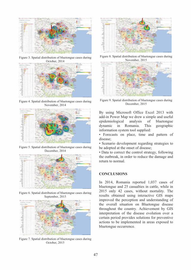
disseminated outside of the Muntenia's hills in September 2014, reaching Dobrogea, Banat, and Transylvania area (fig. 2). In October 2014 bluetongue outbreaks were reported in several Transylvanian counties - Sibiu, Covasna, Mures, Brasov, in Timis county and in Moldavia and Bucovina area (fig. 3). In November 2014, Transylvania and Muntenia areas continuously reported bluetongue outbreaks, while Arad County reported the first cases. The outbreaks reported in Arad County could be the effect of vectors propagation from Timis County (fig. 4). In December 2014 Oltenia area reported new cases, in Dolj, Gorj, Valcea and Olt Counties. Muntenia and Moldavia areas were affected too (fig. 5). In 2015, outbreaks of bluetongue were reported between September and November (fig. 6-9). The first outbreaks of the year were present in Bucovina area (Botosani and Suceava Counties) (fig. 6), followed in October by outbreaks in Moldavia area (Iasi and Vaslui Counties) (fig. 7). In November 2015, new outbreaks were reported in Botosani and Vaslui Counties (fig. 8).
Figure 1. Spatial distribution of bluetongue cases during
August, 2014
Figure 2. Spatial distribution of bluetongue cases during
September, 2014
47
Figure 3. Spatial distribution of bluetongue cases during
October, 2014
Figure 4. Spatial distribution of bluetongue cases during
November, 2014
Figure 5. Spatial distribution of bluetongue cases during
December, 2014
Figure 6. Spatial distribution of bluetongue cases during
September, 2015
Figure 7. Spatial distribution of bluetongue cases during
October, 2015
Figure 8. Spatial distribution of bluetongue cases during
November, 2015
Figure 9. Spatial distribution of bluetongue cases during
December, 2015 By using Microsoft Office Excel 2013 with add-in Power Map we drew a simple and useful epidemiological analysis of bluetongue dynamic in Romania. This geographic information system tool supplied: • Forecasts on place, time and pattern of disease; • Scenario development regarding strategies to be adopted at the onset of disease; • Data to correct the control strategy, following the outbreak, in order to reduce the damage and return to normal.
CONCLUSIONS
In 2014, Romania reported 1,037 cases of bluetongue and 25 casualties in cattle, while in 2015 only 42 cases, without mortality. The results obtained using interactive GIS maps improved the perception and understanding of the overall situation on Bluetongue disease throughout the country. Achievement by GIS interpretation of the disease evolution over a certain period provides solutions for preventive actions to be implemented in areas exposed to bluetongue occurrence.

48
REFERENCES Attoui H., Mertens P.P.C., Becnel J., Belaganahalli S.,
Bergoin M., Brussaard C.P., Chappell J.D., Ciarlet M., Del Vas M., Dermody T.S., Dormitzer P.R., Duncan R., Fang Q., Graham R., Guglielmi K.M., Harding R.M., Hillman B., Makkay A., Marzachì C., Matthijnssens J., Milne R.G., Mohdjaafar F., Mori H., Noordeloos A.A., Omura T., Patton J.T., Rao S., Maan M., Stoltz D., Suzuki N., Upadhyaya N.M., Wei C., Zhou H., 2012. Family Reoviridae. In: Virus Taxonomy: Classification and Nomenclature of Viruses: Ninth Report of the International Committee on Taxonomy of Viruses, King A.M.Q., Adams M.J., Carstens E.B. & Lefkowitz, E.J., eds. Elsevier Academic Press, San Diego, USA.
Gattrell A., Loytonen M., 2003. GIS and Health Research: An Introduction. In: GIS and Health: GISDATA 6. CRC Press, London, UK, 3-16.
Ivana S., Campeanu G., Bogdan A., Danes M., Ipate J., Popescu A., Baraitareanu S., Sandu M., Costache D., 2009. Serological and entomological monitoring of bluetongue in Romania. Scientific Works-University of Agronomical Sciences and Veterinary Medicine,
Bucharest Series C, Veterinary Medicine, 55(1):294–298.
Verwoerd D.W., Erasmus B.J., 2004. Bluetongue. In: Infectious Diseases of Livestock, Second Edition, Coetzer J.A.W. and Tustin R.C., eds. Oxford University Press Southern Africa, Cape Town, South Africa, 1201–1220.
WAHIS (2014a). Bluetongue, Romania. Information received on 24/08/2014, Bucharest, Romania. http://www.oie.int/wahis_2/public/wahid.php/Reviewreport/Review?page_refer=MapFullEventReport&reportid=15910
WAHIS (2014b). Bluetongue, Romania. Summary of Immediate notifications and Follow-ups – 2014. http://www.oie.int/wahis_2/public/wahid.php/Diseaseinformation/Immsummary
WAHIS (2015). Bluetongue, Romania. Summary of Immediate notifications and Follow-ups – 2015. http://www.oie.int/wahis_2/public/wahid.php/Diseaseinformation/Immsummary
Zanella G., Martinelle L., Guyot H., Mauroy A., De Clercq K., Saegerman C., 2013. Clinical pattern characterization of cattle naturally infected by BTV-8. Transboundary and Emerging Diseases, 60(3):231-237.

![א א א - CBOS › sites › default › files › issue_2.pdf · á] çŠÖ]](https://static.fdocuments.net/doc/165x107/5f04116d7e708231d40c290f/-cbos-a-sites-a-default-a-files-a-issue2pdf-.jpg)


