Retford Cemetery Management Plan - Home - …€¦ · Retford Cemetery Management Plan For ... but...
22
Retford Cemetery Management Plan For Local Nature Reserve Retford Cemetery © Margaret Mantaj
Transcript of Retford Cemetery Management Plan - Home - …€¦ · Retford Cemetery Management Plan For ... but...

Retford Cemetery
Management Plan For Local Nature Reserve
Retford Cemetery © Margaret Mantaj

Prepared on behalf of Bassetlaw District Council Contact: Janette Walker Environmental Development Officer Environment & Housing Services Bassetlaw District Council West House Hundred Acre Lane Carlton Forest Worksop Nottinghamshire S81 0TS Tel: 01909 533156 e-mail: [email protected] By Nottinghamshire Wildlife Trust Head Office The Old Ragged School 1 Brook Street Nottingham NG1 1EA Telephone 0115 9588242

3
CONTENTS Page 1. Description 4 2. Evaluation & Objectives 7 3. Proposed Management Projects 10 4. References 16 Appendix 1 – mammal species 17 Appendix 2 – bird species 18 Appendix 3 – other species 19 Appendix 4 – plant species 20
4
1. DESCRIPTION 1.1 Location
Retford cemetery is situated on the western outskirt of Retford town between Babworth Road and North Road (SK 695 815). The railway line runs near the western boundary; the Chesterfield Canal runs along the eastern boundary and separates the northern and southern sections of the cemetery.
1.2 Map Coverage The site (SK 695 815) is covered by Landranger Map 120 (1:50,000 scale) and Explorer Map 279 (1:25,000 scale).
1.3 Owner
Bassetlaw District Council has freehold ownership of the site.
1.4 Size Approximately 10 ha (25 acres).
1.5 Geology The underlying geology of the area is sand and gravel of river terrace deposits of the River Idle (Smith, Rhys and Goossons 1973). This geology should make the soil acidic.
1.6 Aspect, topography and altitude The site is level ground and 20 m above sea level.
1.7 Access There is vehicular access to the site off Babworth Road with a small car park at the entrance to the area of graves. Vehicular access is also possible off the North Road, but the gates are now kept closed to prevent the cemetery being used as a shortcut between North Road and Babworth Road. There is further pedestrian access into the cemetery from the Chesterfield Canal towpath, where the bridge crosses the canal. The cemetery gates are locked in the evening (8 pm or dusk if earlier) and opened in the morning (9 am) by a security firm. There is a network of surfaced paths throughout the cemetery.
1.8 Surrounding land use Situated on the western outskirts of Retford the surrounding land use is residential to the north, east and south, characterised by large houses and mature gardens. The Chesterfield Canal runs along the eastern border of the site and then heads westwards dividing the northern and southern sections of the cemetery. To the west of the site there is a primary school, a railway line, and then the new school off Babworth Road and Babworth Woods. To the west there is also a small area of woodland.

5

6
1.9 Site Description
Retford cemetery is a Victorian era cemetery - the first burial in the cemetery was in 1854. Its age and large size, range of mature trees and the Chesterfield Canal running along its eastern boundary all help to create an environment with different habitats for a variety of wildlife.
1.10 Statutory Designations
No statutory designations. 1.11 Non-statutory Designations
No non-statutory designations

7
2. EVALUATION & OBJECTIVES 2.1 Evaluation of site features
2.1.1 Size The cemetery is approximately 10 ha (25 acres), an important size of green space within Retford.
2.1.2 Diversity The habitat of the site is predominantly parkland – grassland with
mature trees, both native and non-native. There is additional diversity with the riverbank habitat along the Chesterfield Canal.
2.1.3 Naturalness
The site was farmland in the early part of the nineteenth century (Sanderson 1835) and became a cemetery in the mid nineteenth century; the first burial was in 1854. It is now a man-made parkland landscape that includes some mature native and non-native trees. There are areas of formal planting and some native plants have colonised the grass areas.
2.1.4 Rarity
No rare species have been recorded to date, but the bat assemblage is of county importance.
2.1.5 Fragility The site is a working cemetery with burials still occurring so there is
regular but unobtrusive use of the site. The site’s proximity to Retford does make it potentially vulnerable to vandalism, but this not a problem at present.
2.1.6 Typicalness The site is typical of a Victorian cemetery with survey work completed
so far showing that the site supports a bird community and bats typical of a parkland and woodland site.
2.1.7 Recorded history There is little recorded ecological information for the site. Sanderson’s
map shows the area as farmland in 1835 and the site became a cemetery in 1854.
2.1.8 Position in an ecological/geographical unit Retford cemetery is close to the outskirt of the town and near to the
parkland of estates to the west. The Chesterfield Canal Site of Interest for Nature Conservation (SINC 2/621) runs through the site and is a green corridor that links the site to the wider countryside. The major wetland site of Sutton and Lound Gravel Pits Site of Special Scientific Interest (SSSI) is 1.5 km to the north at its closest point – the southernmost lake of the SSSI (Bellmoor Pit). Bolham Lane (SINC

8
1/140) and Bolham Mill (SINC 2/1040) geological features are 1.5 km to the north east.
2.1.9 Potential value There is the potential to conserve and further enhance the biodiversity
value of the site and to designate it as a Local Nature Reserve. 2.1.10 Intrinsic appeal The mature Victorian parkland landscape is an attractive and peaceful
environment.
2.1.11 Biodiversity The first edition of the Local Biodiversity Action Plan for Nottinghamshire is an important document, which lists species and habitats of conservation concern in the county, based on national and local criteria. It includes Habitat Action Plans (HAPs) and Species Action Plans (SAPs), to cover those species whose requirements are not adequately encompassed in the HAPs. Managing areas of key habitat within its estate is one of Bassetlaw District Council’s most important contributions to Local Biodiversity Action Plan targets.
In the case of Retford Cemetery, the following Habitat (HAPs) and Species Action Plans (SAPs) apply:
• Urban and post-industrial habitats • Bats

9
2.2 Management Objectives
The site is a working cemetery so all proposals will consider that as a first priority. Designation as a Local Nature Reserve will recognise the existing biodiversity interest of the site and the aim is to manage and enhance the site to make it a more pleasant environment for visitors. To enhance the biodiversity of the site there needs to be the following objectives:
• Conserve and enhance the habitats on the site, and the wildlife interest of
those habitats.
• Maintain or increase populations of species which are near the limits of their range, or are at least locally uncommon.
• Provide interpretation for the site.
• Add to the body of ecological information concerning the site, in particular
conduct the following surveys:
• Invertebrate survey
• Further botanical surveys, including identification of specimen trees
• Further bat activity survey
• Lichen survey of old headstones
10
3. PROPOSED MANAGEMENT PROJECTS
Based on the surveys of the site a set of management proposals that would enhance the site’s biodiversity are proposed.
3.1 Conserve and enhance the habitats on the site, and the wildlife interest of
those habitats. Increase number of native plant species The biodiversity value of the site could be greatly enhanced by increasing the
number of native tree, shrub and flower species, and non-native species that are attractive to invertebrates.
• Plant native tree and shrub species that are typical of the area, and
ideally of local provenance. Use species that have berries for birds and provide good structure for nesting (e.g., hawthorn and wild privet), and attract butterflies (e.g., purging buckthorn for brimstone and holly for holly blue).
• Enhance the botanical diversity of the grassland areas by planting plugs of native flowers, typical of the area and ideally of local provenance. Areas could be irregular swathes against the shrub borders, or amongst the trees in the parkland landscape. As part of such a management programme the site could be managed as a Blue Butterfly site.
• Plant some non-native species that are attractive to invertebrates, especially butterflies and moths (e.g., buddleia, ice plant and red valerian), but not at the detriment to native species.
• Modify the mowing regime of wildflower areas by reducing the number of cuts and timing them to benefit wildflowers. Removal of arisings is important to reduce soil fertility and improve the appearance of grasslands.
• Reduce the application of herbicides, pesticides and fertilisers. 3.2 Maintain or increase populations of species which are near the limits of
their range, or are at least locally uncommon. Bats (UK Bioidiversity Action Plan Priority Species, Local BAP) The bat surveys found several individuals of different bat species feeding over
the site. Food supply will be increased by increasing the number and diversity of native plant species.
Bat boxes could be installed to provide roost and shelter sites. The best
locations for boxes to be installed would be high up in the mature trees along the canal or on trees by the railway line.
Trees need to be surveyed for bat roosts before any tree works are undertaken.

11
House sparrow House sparrows occur on the site. Although it is a relatively common species it
has undergone a decline greater than 50 % in the last 25 years so it is a Red List Bird of Conservation Concern (Gregory et al. 2002). House sparrows nest in cavities so can be helped by installing bird nest boxes. However, like many birds, house sparrows feed their chicks on invertebrates so increasing the number and diversity of native plants will increase invertebrates.
Song thrush Song thrush occurs on site. It also has undergone a decline greater than 50 %
in the last 25 years so it is a Red List Bird of Conservation Concern and is also a UK Biodiversity Action Plan Priority Species. A large part of its diet is molluscs, especially snails, and it is important to use non-toxic molluscides. Planting shrubs that provide thick nesting cover and winter berries will also help this species.
Starling Although it is a relatively common species it has undergone a decline greater
than 50 % in the last 25 years so it is a Red List Bird of Conservation Concern (Gregory et al. 2002). The species nests in a cavity and will use large nest boxes. If nest boxes were to be installed the best locations would be high up in the mature trees along the eastern boundary of the site.
Starlings feed in short turf and reducing the use of pesticide will help this
species. Spotted Flycatcher A Red List Bird of Conservation Concern (Gregory et al. 2002). Spotted
flycatchers make a nest in the fork of a tree, behind ivy or on a buildling (often in a recess). It will use nest boxes but they are probably best avoided to keep nesting sites concealed from disturbance. Increasing the number and diversity of plants that attract insects will help this species, as will reducing the use of pesticides. A single bird was seen in 2007.
3.3 Provide interpretation for the site. To increase understanding and appreciation of the site’s wildlife the following
measures are proposed:
• Install an interpretation panel that has a map of the cemetery and provides information on the wildlife.
• Wildflower areas can be signed with ‘Blue Butterfly’ plaques and an
accompanying leaflet about the Blue Butterfly scheme is available.
• Produce a leaflet detailing the wildlife of the site.
• Provide a programme of guided walk events.

12
3.4 Add to the body of ecological information concerning the site, in particular conduct the following surveys.
Further ecological information for the site will help to inform management decisions and fine tune the proposed management options. It is recommended that the following surveys are undertaken:
• Soil sampling to establish soil type, pH and nutrient levels (if the
information is not already available). This information will help select wildflowers species for grassland enhancement.
• Further botanical survey. • Bat activity survey. • Invertebrate surveys (e.g., butterfly survey). • Lichen survey of headstones.
When possible work with local recording groups to build up the ecological information for the site.
13
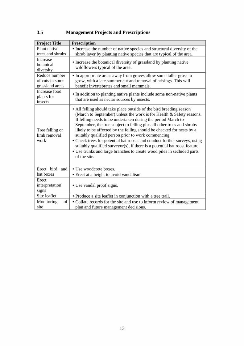
3.5 Management Projects and Prescriptions Project Title Prescription Plant native trees and shrubs
• Increase the number of native species and structural diversity of the shrub layer by planting native species that are typical of the area.
Increase botanical diversity
• Increase the botanical diversity of grassland by planting native wildflowers typical of the area.
Reduce number of cuts in some grassland areas
• In appropriate areas away from graves allow some taller grass to grow, with a late summer cut and removal of arisings. This will benefit invertebrates and small mammals.
Increase food plants for insects
• In addition to planting native plants include some non-native plants that are used as nectar sources by insects.
Tree felling or limb removal work
• All felling should take place outside of the bird breeding season (March to September) unless the work is for Health & Safety reasons. If felling needs to be undertaken during the period March to September, the tree subject to felling plus all other trees and shrubs likely to be affected by the felling should be checked for nests by a suitably qualified person prior to work commencing.
• Check trees for potential bat roosts and conduct further surveys, using suitably qualified surveyor(s), if there is a potential bat roost feature.
• Use trunks and large branches to create wood piles in secluded parts of the site.
Erect bird and bat boxes
• Use woodcrete boxes. • Erect at a height to avoid vandalism.
Erect interpretation signs
• Use vandal proof signs.
Site leaflet • Produce a site leaflet in conjunction with a tree trail. Monitoring of site
• Collate records for the site and use to inform review of management plan and future management decisions.

14
3.6 Five Year Work Plan
Y e a r s Prescription 1 2 3 4 5
Plant native trees and shrubs 1 1 1 1 1
Increase botanical diversity 1 1 1 1 1
Reduce number of cuts in some grassland areas
2 2 2 2 2
Protected species surveys prior to tree felling or limb removal work
1 1 1 1 1
Erect bird and bat boxes 2
Erect interpretation signs 2 2
Site leaflet 2
Guided walks 1 1 1 1 1
Monitoring of site 1 1 1 1 1
Priority – 1 is high, 2 is medium, 3 is low

15
REFERENCES Gregory et al. (2002). The population status of birds in the United Kingdom, Channel Islands and the Isle of Man: an analysis of conservation concern 2002 – 2007. British Birds 95: 410 – 450.
Nottinghamshire Biodiversity Action Group. Taylor, J. K. (ed.)(1998). Local Biodiversity Action Plan for Nottinghamshire. Nottinghamshire County Council. Sanderson, G (1835). Twenty Miles round Mansfield. Derbyshire County Council and Nottinghamshire County Council (2001 reprint). Smith, E.G., Rhys, G. H. and Goossons, R. F. (1973). Geology of the country around East Retford, Worksop and Gainsborough – a memoir of the Geological Survey of Great Britain (including Geological Sheet 101). HMSO, London.

16
Appendix 1 – mammal species The following mammals have been recorded in Retford Cemetery since 2006 by Nottinghamshire Wildlife Trust and North Notts Bat Group. Hedgehog Mole Rabbit Grey squirrel Common pipistrelle Soprano pipistrelle Daubenton’s bat – Chesterfield Canal Noctule Brown long-eared bat

17
Appendix 2 – bird species The following bird species have been recorded since 2006 by Nottinghamshire Wildlife Trust.
Species Status Sparrowhawk R Moorhen R (B Chesterfield Canal) Stock dove R (B?) Woodpigeon RB Collared dove RB Swift SV Green woodpecker R (B?) Great spotted woodpecker R (B?) House martin SV Pied wagtail RB Wren RB Dunnock RB Robin RB Blackbird RB Song thrush RB Redwing WV Mistle thrush RB Blackcap SV B Chiffchaff SV B Goldcrest RB Long-tailed tit RB Coal tit RB Blue tit RB Great tit RB Treecreeper R (B?) Nuthatch R (B?) Jay R (B?) Magpie R (B?) Jackdaw R Carrion crow R Starling R (B?) House sparrow R Chaffinch RB Greenfinch RB Goldfinch RB Bullfinch R (B?) Siskin WV Code: R = resident; SV = summer visitor; WV = winter visitor; B = breeds.

18
Appendix 3 – other species The following species have been recorded by Nottinghamshire Wildlife Trust since 2006. Amphibians Common toad – two found squashed on path in spring 2007 Butterflies Large white Small white Green-veined white Orange-tip Holly blue Red admiral Small tortoiseshell Peacock Comma Speckled wood Damsel and dragonflies Common blue damselfly Emperor Southern hawker Common darter

19
Appendix 4 – plants Incidental plant records from 2006 onwards by Nottinghamshire Wildlife Trust. Creeping buttercup Lesser celandine Wood anemone Common poppy Common fumitory Hedge mustard Hairy bitter-cress Cuckoo flower Garlic mustard Shepherd’s-purse Common chickweed Common mouse-ear Spring beauty Musk mallow Herb Robert Dove’s-foot crane’s-bill Yellow oxalis White clover Black medick Common bird’s-foot-trefoil Bramble agg. Meadow saxifrage White stonecrop Square-stemmed willowherb Common nettle Cow parsley Hogweed Wood dock Curled dock Common sorrel Sheep’s sorrel Common knotgrass Redshank Primrose Scarlet pimpernel Hedge bindweed Black nightshade Thyme-leaved speedwell Germander speedwell Ground ivy Selfheal Green alkanet Ribwort plantain Greater plantain Cleavers Common ragwort
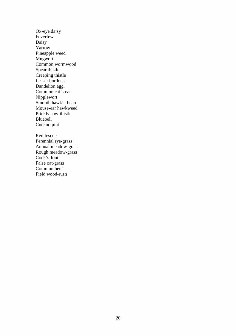
20
Ox-eye daisy Feverfew Daisy Yarrow Pineapple weed Mugwort Common wormwood Spear thistle Creeping thistle Lesser burdock Dandelion agg. Common cat’s-ear Nipplewort Smooth hawk’s-beard Mouse-ear hawkweed Prickly sow-thistle Bluebell Cuckoo pint Red fescue Perennial rye-grass Annual meadow-grass Rough meadow-grass Cock’s-foot False oat-grass Common bent Field wood-rush

21
Appendix 5 -Time budget for projects Project Title Prescription Number of days per year
Plant native trees and shrubs
• Increase the number of native species and structural diversity of the shrub layer by planting native species that are typical of the area.
Areas have already been identified and shrubs planted.
Increase botanical diversity
• Increase the botanical diversity of grassland by planting native wildflowers typical of the area.
Two bulb planting sessions with The Friends of Group have taken place. Have two further planting days over
period of management plan.
Reduce number of cuts in some grassland areas
• In appropriate areas away from graves allow some taller grass to grow, with a late summer cut and removal of arisings. This will benefit invertebrates and small mammals.
Fit into present Bassetlaw District Council maintenance
programme.
Increase food plants for insects
• In addition to planting native plants include some non-native plants that are used as nectar sources by insects.
Have two planting days over period of management plan.
Tree felling or limb removal work
• All felling should take place outside of the bird breeding season (March to September) unless the work is for Health & Safety reasons. If felling needs to be undertaken during the period March to September, the tree subject to felling plus all other trees and shrubs likely to be affected by the felling should be checked for nests by a suitably qualified person prior to work commencing.
• Check trees for potential bat roosts and conduct further surveys, using suitably qualified surveyor(s), if there is a potential bat roost feature.
• Use trunks and large branches to create wood piles in secluded parts of the site.
This is reactive remedial work to make trees safe so number
of days will vary.
Erect bird and bat boxes
• Use woodcrete boxes. • Erect at a height to avoid
vandalism.
Bird and bat boxes have already been erected. Have one further day of erecting
different boxes. Erect interpretation signs
• Use vandal proof signs. One sign at the Babworth Road entrance has been
installed.
Site leaflet • Produce a site leaflet in conjunction with a tree trail.
Allow five days to prepare leaflet.

22