RESTORING TRUCKEE MEADOWS - … Truckee Meadows... · The Truckee River Watershed covers 3120...
35
RESTORING TRUCKEE MEADOWS: ASSESSMENT AND PRIORITIZATION February 2018 A report supported by the National Fish and Wildlife Foundation Results of a broadly-collaborative effort to prioritize meadows in the Truckee River Watershed for restoration.
Transcript of RESTORING TRUCKEE MEADOWS - … Truckee Meadows... · The Truckee River Watershed covers 3120...
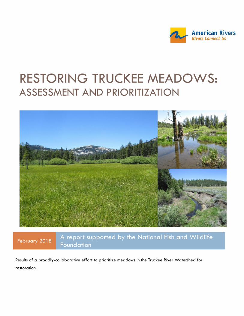
RESTORING TRUCKEE MEADOWS: ASSESSMENT AND PRIORITIZATION
February 2018 A report supported by the National Fish and Wildlife Foundation
Results of a broadly-collaborative effort to prioritize meadows in the Truckee River Watershed for
restoration.
Restoring Walker Meadows
Page 1
Restoring Truckee Meadows: Assessment and Prioritization
Maiya Greenwood, Julie Fair, Meg Hanley, Jacob Dyste, and Luke Hunt 2018.
Restoring Truckee Meadows: Assessment and Prioritization. A report by
American Rivers submitted to the National Fish and Wildlife Foundation.
Restoring Walker Meadows
Page 2
CONTENTS
CONTENTS ........................................................................................................................... 2
INTRODUCTION ................................................................................................................... 3
THE TRUCKEE RIVER WATSERSHED ..................................................................................... 3
The Middle Truckee River Watershed .................................................................................................. 5
METHODS ............................................................................................................................ 6
RESULTS AND DISCUSSION OF CONDITION DATA ............................................................ 7
PRIORITIES ........................................................................................................................... 9
Reservoirs ................................................................................................................................................ 10
PRIORITIZATION FOR LAHONTAN CUTTHROAT TROUT ................................................. 14
INFLUENCE OF BEAVER ..................................................................................................... 14
CONCLUSION .................................................................................................................... 15
TRUCKEE RIVER MEADOWS ASSESSMENT DATA .............................................................. 16
Alder Creek Meadow .......................................................................................................................... 16
Hoke Valley Meadow .......................................................................................................................... 17
Dog Valley ............................................................................................................................................. 18
Sardine Valley ....................................................................................................................................... 19
Lower Lacey Meadow .......................................................................................................................... 20
Secret Meadow ..................................................................................................................................... 21
Stampede Dam Road Meadow.......................................................................................................... 22
Russel Valley- Dry Creek ..................................................................................................................... 23
Stampede Meadow .............................................................................................................................. 24
Hobart Mills Meadow........................................................................................................................... 25
Kyburz Flat Meadow ............................................................................................................................ 26
Ranz Dry Meadow ................................................................................................................................ 27
Pink Mine Meadow ............................................................................................................................... 28
Unnamed Meadow 36 ......................................................................................................................... 29
Sagehen Meadow ................................................................................................................................. 30
Upper Independence Creek Meadow .............................................................................................. 31
Other Meadows for Consideration .................................................................................................... 32
Restoring Walker Meadows
Page 3
INTRODUCTION Meadows of the Truckee River Watershed are an extremely valuable component of the landscape.
They reduce peak flows during storms and soak up spring runoff, recharging groundwater supplies.
Meadows filter sediment, provide forage, and are important cultural and recreational sites. However,
the National Fish and Wildlife Foundation (NFWF) estimates that half of all meadows in the Sierra
Nevada are degraded and no longer provide these natural benefits (NFWF 2010). Fortunately, there
are methods to restore the condition of unhealthy meadows, and investment in meadow restoration is
expanding rapidly. Investors- including NFWF and other foundations, state and federal agencies,
corporations, ranchers and land managers- seek to provide the largest return on their restoration
investment. Therefore, an important question is which meadows, if restored, will provide the greatest
value? To answer this question, American Rivers partnered with the Forest Service and NFWF to
develop a scorecard to rapidly evaluate meadow condition and prioritize meadows for restoration
(American Rivers 2012). The method has been applied in the Yuba, American, Mokelumne, Kern,
Carson, Walker, and Tuolumne River watersheds, and a similar effort is underway in Sequoia National
Forest and Sequoia and Kings Canyon National Parks. UC Davis has developed a database to store
this “Meadow Scorecard” data (http://meadows.ucdavis.edu/assessments/map). This assessment
method has been used to identify dozens of high priority meadows and thereby focused our efforts
and accelerated restoration.
Between 2014 and 2017, American Rivers was funded by NFWF to use the meadow scorecard in the
Middle Truckee River Basin to focus investment and accelerate the pace of restoration. We assessed
every accessible meadow in the watershed that is larger than 15 acres, 30 in all. We prioritized these
meadows for restoration with a working group comprised of local stakeholders who are actively and
strategically pursing restoration in the watershed. These stakeholders included non-profit organizations
(Truckee River Watershed Council, The Nature Conservancy, Trout Unlimited, Truckee Donner Land
Trust, Institute for Bird Populations, Trust for Public Land, the Northern Sierra Partnership, and American
Rivers) and land managers (Tahoe National Forest, Humbolt-Toiyabe National Forest, California
Department of Fish and Wildlife, and US Fish and Wildlife Service). We identified 6 priority meadows
in the Middle Truckee River watershed.
The purpose of this Truckee River Meadows Condition Report is twofold. First, we present condition
data to highlight meadow restoration potential in the Truckee River watershed. Second, it provides
information to inform the stakeholder group for planning subsequent restoration efforts once the first
group of meadows is restored.
THE TRUCKEE RIVER WATSERSHED The Truckee River Watershed covers 3120 square miles of California and Nevada. The Truckee River
flows northeast for 121 miles from Lake Tahoe in the Upper Truckee watershed, through the Middle
Truckee Watershed, and to Pyramid Lake in the Lower Truckee watershed. Derby Dam, located
between Reno and Fernley, diverts water from the river into the Truckee Canal (National Park Service
n.d.). The diverted water flows to the Lahontan Reservoir for irrigation use. The Truckee River provides
80% of drinking water to the residents in Reno, Sparks and the Washoe County areas (City of Reno).

Restoring Walker Meadows
Page 4
FIGURE 1. THE TRUCKEE RIVER WATERSHED IS COMPOSED OF THE UPPER, MIDDLE, AND LOWER WATERSHEDS. WE ASSESSED MEADOWS
IN THE MIDDLE TRUCKEE WATERSHED.
The watershed supports many wildlife species and numerous focal species, including federally
threatened Lahontan Cutthroat Trout (LCT). Historically, LCT inhabited an estimated 360 miles of cold
water stream habitat and 284,000 acres of lake habitat in Nevada and California. The largest
populations were in Lake Tahoe and Pyramid Lake. LCT populations declined in the late 1930s due to
dams and diversions, introductions of exotic competitors, pollution, and commercial fishing. The current
LCT range is now limited to about 8 miles of habitat comprising approximately 2.2% of the historic
stream distribution (Coffin and Cowan 1995). There are stronghold populations in Pyramid (currently
stocked,) and Independence Lake (Middle Truckee Watershed). Independence Lake has the only self-
sustaining lacustrine LCT population in the Truckee River (US Department of the Interior 2009).
Restoring Walker Meadows
Page 5
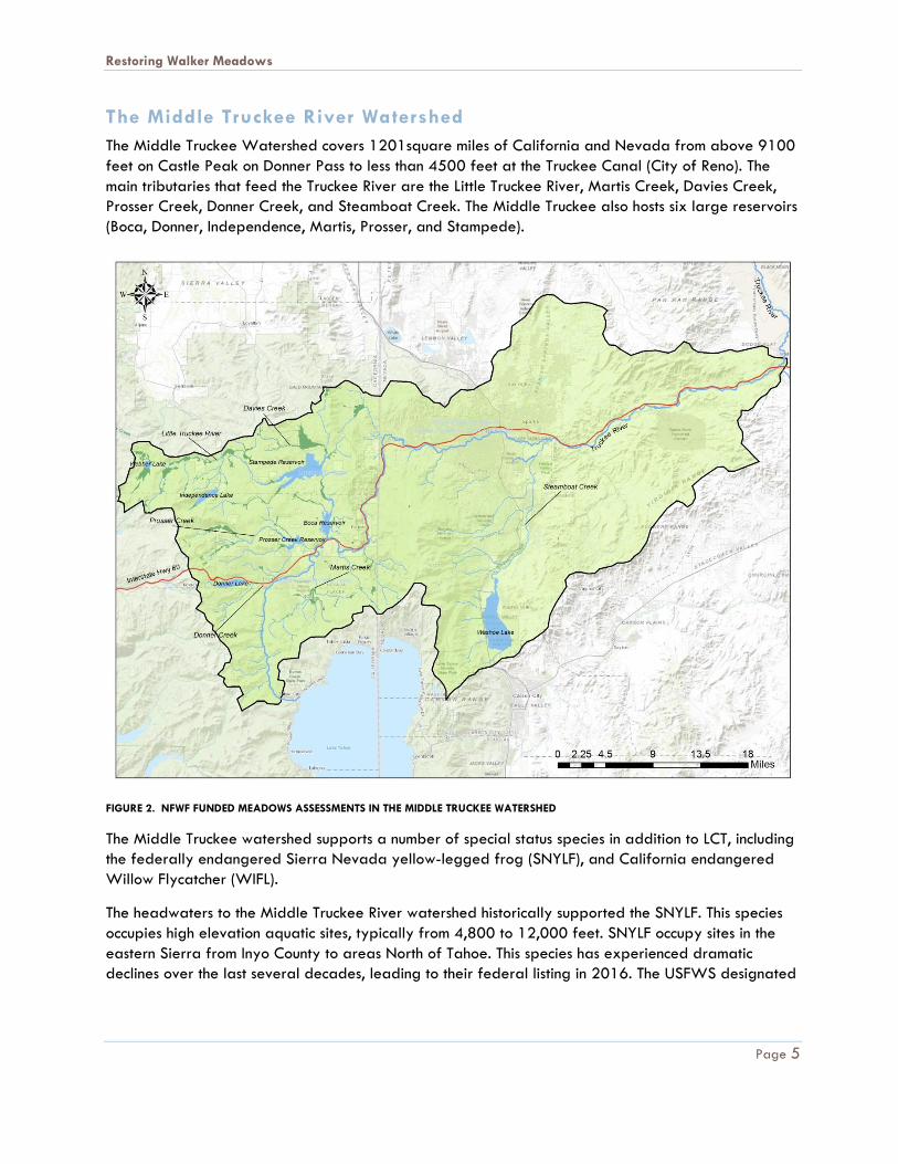
The Middle Truckee River Watershed
The Middle Truckee Watershed covers 1201square miles of California and Nevada from above 9100
feet on Castle Peak on Donner Pass to less than 4500 feet at the Truckee Canal (City of Reno). The
main tributaries that feed the Truckee River are the Little Truckee River, Martis Creek, Davies Creek,
Prosser Creek, Donner Creek, and Steamboat Creek. The Middle Truckee also hosts six large reservoirs
(Boca, Donner, Independence, Martis, Prosser, and Stampede).
FIGURE 2. NFWF FUNDED MEADOWS ASSESSMENTS IN THE MIDDLE TRUCKEE WATERSHED
The Middle Truckee watershed supports a number of special status species in addition to LCT, including
the federally endangered Sierra Nevada yellow-legged frog (SNYLF), and California endangered
Willow Flycatcher (WIFL).
The headwaters to the Middle Truckee River watershed historically supported the SNYLF. This species
occupies high elevation aquatic sites, typically from 4,800 to 12,000 feet. SNYLF occupy sites in the
eastern Sierra from Inyo County to areas North of Tahoe. This species has experienced dramatic
declines over the last several decades, leading to their federal listing in 2016. The USFWS designated
Restoring Walker Meadows
Page 6
critical habitat areas for this species that occur at very high elevation sites in the Truckee River
watershed.
The meadows in the Middle Truckee supply important breeding habitat for the WIFL. This small insect-
eating migrant bird was once common throughout much of the Sierra, but has declined steeply since the
middle of twentieth century. There are three subspecies of WIFL that occur in California and all three
are listed as State Threatened and U.S. Forest Service Region 5 Sensitive in California. Researchers
have noted that WIFL appear to have stopped breeding at many historically occupied meadow sites
throughout their range in the Sierra (Helen Loffland et al. 2014). All of the meadows in the Middle
Truckee River Watershed are within the 12 kilometer dispersal range for Willow Flycatcher.
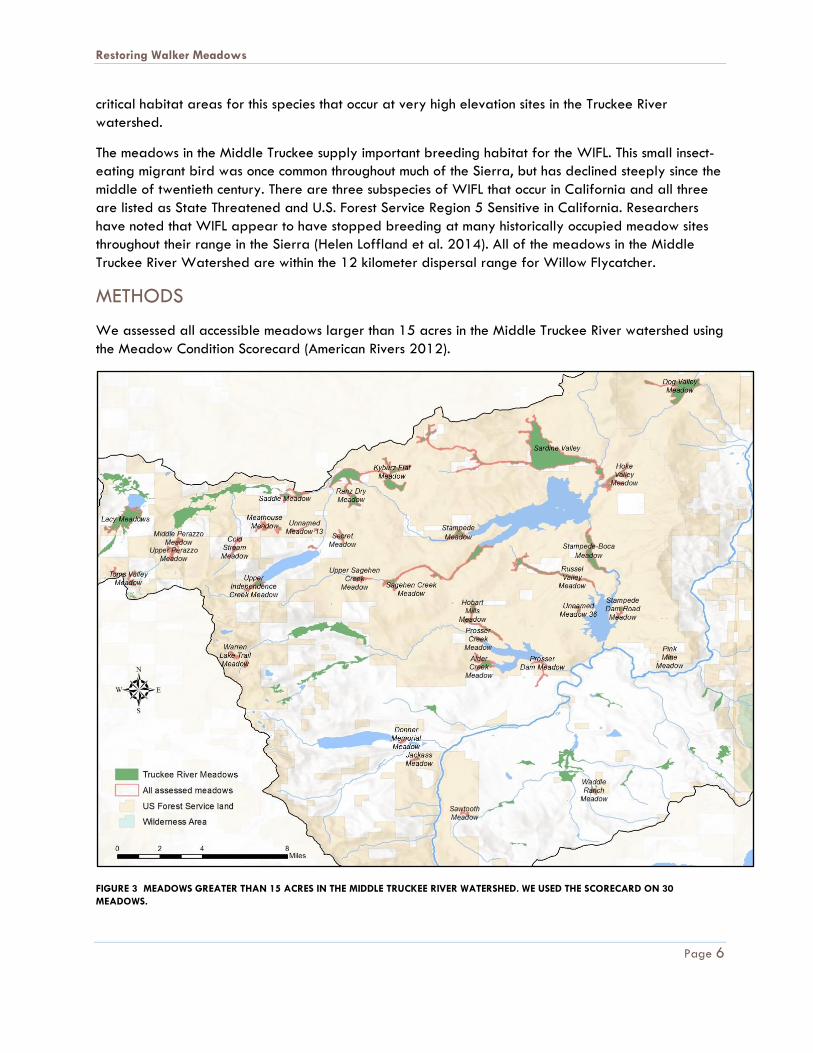
METHODS
We assessed all accessible meadows larger than 15 acres in the Middle Truckee River watershed using
the Meadow Condition Scorecard (American Rivers 2012).
FIGURE 3 MEADOWS GREATER THAN 15 ACRES IN THE MIDDLE TRUCKEE RIVER WATERSHED. WE USED THE SCORECARD ON 30
MEADOWS.
Restoring Walker Meadows
Page 7
The scorecard is a rapid field assessment method that quickly scores channel and vegetation conditions
to identify impacted meadows. The scorecard is based on the framework of the EPA Physical Habitat
Assessment (Barbour et al. 1999) and uses metrics from the Bureau of Land Management Multiple
Indicators Monitoring (MIM) Protocol and Proper Function Conditions (PFC) methods (USDI-BLM, USDA-
Forest Service, and USDA-NRCS 1998), as well as a vegetation indicator developed by Dave
Weixelman, Forest Service Range Ecologist for Region 5 (unpublished data). The scorecard is
qualitative in nature; however, the scoring is based on quantitative measurements, such as bank height,
percent bare ground, and length of gullies. These measurements and methods enable multiple
observers to be field-calibrated and return consistent results throughout a watershed.
Meadow condition was scored using six qualitative measures that can receive a high score of 4 and a
low score of 1:
1. Bank height
2. Bank stability (percent that is unstable)
3. Length of gullies and ditches (compared to the length of the channel)
4. Vegetation cover (graminoid/forb ratio)
5. Bare Ground (percent of meadow area)
6. Conifer or upland shrub encroachment (percent of meadow area)
In addition, the scorecard includes a checklist of anecdotal observations, such as past restoration
efforts, roads in or adjacent to the meadow, grazing observations, and evidence of beaver.
To begin our assessment in the Truckee, we used GIS layers provided by UC Davis and the California
Department of Fish and Wildlife (CDFW) to identify all the meadows in the watershed larger than 15
acres. Initially, we identified 39 meadows. We did not survey 9 of these; five were incorrectly
delineated from remote data and were in reality smaller than 15 acres, and the other four were
discounted as meadows because they were dominated by willow, which is not consistent with the
mountain meadow ecosystem definition described in the scorecard.
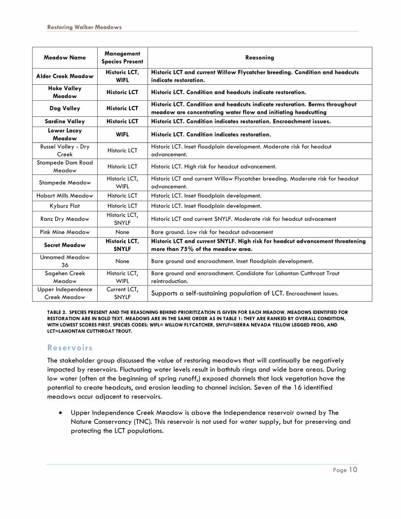
RESULTS AND DISCUSSION OF CONDITION DATA
The results for the lowest-scoring meadows (the bottom 50%) are shown in Table 1. In addition to
condition data, we include the number of actively eroding headcuts. The names of the meadows
prioritized for restoration appear in bold text (see the section on Priorities, below).
A score of 1 or 2 indicates either a substantial level of impact or an unusual environmental setting. For
example, large areas of bare ground may be present where soils are well drained (coarse grained or
steeper slopes) and where gopher activity is high. Meadows with scores in this range require a closer
look to decide if there is a need for restoration, a change in management, or if the meadow condition
is within the normal range for its particular site. Because information on a meadow’s historical condition
is rarely available for comparison there is no absolute method to identify and evaluate impacts (aerial
photographs sometimes show the progression of encroachment by upland shrubs, but channel incision
almost always predates aerial photography). It often takes field visits with an interdisciplinary team to
Restoring Walker Meadows
Page 8
decide whether a meadow is a candidate for restoration. The purpose of the data in Table 1 is to
distinguish between meadows that need a closer look and those that are in good condition.
Meadow Name Bank
Height Bank
Stability Gullies
Vegetation Cover
Bare Ground
Encroachment Number of Headcuts
Alder Creek Meadow 1 2 2 4 3 2 7
Hoke Valley Meadow 1 4 4 3 3 1 5
Dog Valley 1 3 3 4 3 1 2
Sardine Valley 2 2 3 2 2 1 1
Lower Lacey Meadow 2 3 4 3 3 3 0
Russel Valley - Dry Creek 3 4 3 3 2 1 3
Stampede Dam Road Meadow
3 3 3 4 2 3 2
Stampede Meadow 3 4 3 3 4 2 2
Hobart Mills Meadow 3 3 3 3 2 3 1
Kyburz Flat 3 3 3 4 3 1 0
Ranz Dry Meadow 4 4 3 3 1 2 2
Pink Mine Meadow 4 4 4 3 1 2 2
Secret Meadow 4 4 4 3 3 3 1
Unnamed Meadow 36 4 4 4 3 1 1 0
Sagehen Creek Meadow 4 4 4 3 4 2 0
Upper Independence Creek Meadow
4 4 4 4 4 2 0
TABLE 1. THE CONDITION AND NUMBER OF HEADCUTS FOR THE 16 LOWEST SCORING MEADOWS. NOTE THE COLOR AXIS FOR THE
HEADCUT COLUMN DIFFERS FROM THE COLORS FOR THE CONDITION SCORES.
Restoring Walker Meadows
Page 9
Top priorities include the meadows with the poorest channel conditions as well as Secret Meadow,
which was identified because it has a large headcut at the bottom threatening the entire meadow
area.
Two patterns are evident in Table 1. First, most meadows are affected by encroachment of upland
species, including Large Sagebrush (Artemesia tridentata). Encroachment is present in meadows with and
without downcut stream channels. The cause of encroachment likely varies between meadow and may
include fire suppression, historic overgrazing that enabled the recruitment of upland species into bare
areas or naturally well-drained areas that were misidentified as encroachment.
The second pattern is that meadows with high banks tend also tend to have unstable banks and
headcuts that are a result of channel incision. (The process of incision, headcutting and erosion has been
descriptively called “unravelling.”) Meadows showing this second pattern of impact are the meadows
that we identify for potential re-watering, using restoration designs that reverse incision and
simultaneously address bank instability, headcutting and encroachment of upland species.
In addition to patterns of past impacts, headcuts are an indication of risk from future erosion. Often
headcuts are a symptom of incision because after the channel has incised the beds of tributaries and
swales downcut to reach the elevation of the incised channel. These headcuts may be best treated by
fixing the root cause, namely incision. In other cases, for example, Secret Meadow, the headcuts are
extending from a more recent nickpoint such as a culvert or roadbed. For these meadows, treating a
headcut may be the stitch in time that saves nine.
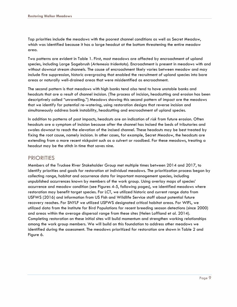
PRIORITIES Members of the Truckee River Stakeholder Group met multiple times between 2014 and 2017, to
identify priorities and goals for restoration at individual meadows. The prioritization process began by
collecting range, habitat and occurrence data for important management species, including
unpublished occurrences known by members of the work group. Using overlay maps of species’
occurrence and meadow condition (see Figures 4-5, following pages), we identified meadows where
restoration may benefit target species. For LCT, we utilized historic and current range data from
USFWS (2016) and information from US Fish and Wildlife Service staff about potential future
recovery reaches. For SNYLF we utilized USFWS designated critical habitat areas. For WIFL, we
utilized data from the Institute for Bird Populations for recent breeding season detections (since 2000)
and areas within the average dispersal range from these sites (Helen Loffland et al. 2014).
Completing restoration on these initial sites will build momentum and strengthen working relationships
among the work group members. We will build on this foundation to address other meadows we
identified during the assessment. The meadows prioritized for restoration are shown in Table 2 and
Figure 6.
Restoring Walker Meadows
Page 10
Meadow Name Management
Species Present Reasoning
Alder Creek Meadow Historic LCT,
WIFL
Historic LCT and current Willow Flycatcher breeding. Condition and headcuts
indicate restoration.
Hoke Valley
Meadow Historic LCT Historic LCT. Condition and headcuts indicate restoration.
Dog Valley Historic LCT Historic LCT. Condition and headcuts indicate restoration. Berms throughout
meadow are concentrating water flow and initiating headcutting
Sardine Valley Historic LCT Historic LCT. Condition indicates restoration. Encroachment issues.
Lower Lacey
Meadow WIFL Historic LCT. Condition indicates restoration.
Russel Valley - Dry
Creek Historic LCT
Historic LCT. Inset floodplain development. Moderate risk for headcut
advancement.
Stampede Dam Road
Meadow Historic LCT Historic LCT. High risk for headcut advancement.
Stampede Meadow Historic LCT,
WIFL
Historic LCT and current Willow Flycatcher breeding. Moderate risk for headcut
advancement.
Hobart Mills Meadow Historic LCT Historic LCT. Inset floodplain development.
Kyburz Flat Historic LCT Historic LCT. Inset floodplain development.
Ranz Dry Meadow Historic LCT,
SNYLF Historic LCT and current SNYLF. Moderate risk for headcut advacement
Pink Mine Meadow None Bare ground. Low risk for headcut advacement
Secret Meadow Historic LCT,
SNYLF
Historic LCT and current SNYLF. High risk for headcut advancement threatening
more than 75% of the meadow area.
Unnamed Meadow
36 None Bare ground and encroachment. Inset floodplain development.
Sagehen Creek
Meadow
Historic LCT,
WIFL
Bare ground and encroachment. Candidate for Lahontan Cutthroat Trout
reintroduction.
Upper Independence
Creek Meadow
Current LCT,
SNYLF Supports a self-sustaining population of LCT. Encroachment issues.
TABLE 2. SPECIES PRESENT AND THE REASONING BEHIND PRIORITIZATION IS GIVEN FOR EACH MEADOW. MEADOWS IDENTIFIED FOR
RESTORATION ARE IN BOLD TEXT. MEADOWS ARE IN THE SAME ORDER AS IN TABLE 1: THEY ARE RANKED BY OVERALL CONDITION,
WITH LOWEST SCORES FIRST. SPECIES CODES: WIFL= WILLOW FLYCATCHER, SNYLF=SIERRA NEVADA YELLOW LEGGED FROG, AND
LCT=LAHONTAN CUTTHROAT TROUT.
Reservoirs
The stakeholder group discussed the value of restoring meadows that will continually be negatively
impacted by reservoirs. Fluctuating water levels result in bathtub rings and wide bare areas. During
low water (often at the beginning of spring runoff,) exposed channels that lack vegetation have the
potential to create headcuts, and erosion leading to channel incision. Seven of the 16 identified
meadows occur adjacent to reservoirs.
Upper Independence Creek Meadow is above the Independence reservoir owned by The
Nature Conservancy (TNC). This reservoir is not used for water supply, but for preserving and
protecting the LCT populations.
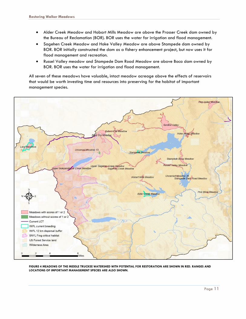
Restoring Walker Meadows
Page 11
Alder Creek Meadow and Hobart Mills Meadow are above the Prosser Creek dam owned by
the Bureau of Reclamation (BOR). BOR uses the water for irrigation and flood management.
Sagehen Creek Meadow and Hoke Valley Meadow are above Stampede dam owned by
BOR. BOR initially constructed the dam as a fishery enhancement project, but now uses it for
flood management and recreation.
Russel Valley meadow and Stampede Dam Road Meadow are above Boca dam owned by
BOR. BOR uses the water for irrigation and flood management.
All seven of these meadows have valuable, intact meadow acreage above the effects of reservoirs
that would be worth investing time and resources into preserving for the habitat of important
management species.
FIGURE 4 MEADOWS OF THE MIDDLE TRUCKEE WATERSHED WITH POTENTIAL FOR RESTORATION ARE SHOWN IN RED. RANGES AND
LOCATIONS OF IMPORTANT MANAGEMENT SPECIES ARE ALSO SHOWN.
Restoring Walker Meadows
Page 12
FIGURE 5 MEADOWS IN THE TRUCKEE RIVER WATERSHED WITH HEADCUTS ARE SHOWN IN RED. RANGES OF IMPORTANT MANAGEMENT
SPECIES ARE ALSO SHOWN.
Restoring Walker Meadows
Page 13
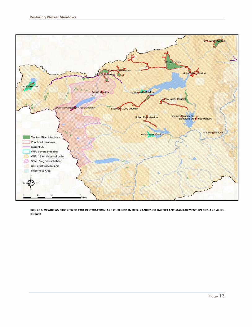
FIGURE 6 MEADOWS PRIORITIZED FOR RESTORATION ARE OUTLINED IN RED. RANGES OF IMPORTANT MANAGEMENT SPECIES ARE ALSO
SHOWN.
Restoring Walker Meadows
Page 14
PRIORITIZATION FOR LAHONTAN CUTTHROAT TROUT
One goal of this assessment was to evaluate meadow restoration opportunities to benefit LCT.
However, only one meadow assessed occurs on a reach that currently supports a self-sustaining
population of LCT, Upper Independence Creek (Figures 4-6). The channel through this meadow is low,
with stable vegetated banks. The sole issue is conifer encroachment. Thus, we do not envision the need
for a restoration project at this site to improve LCT habitat.
The CDFW Fish Release Plan for 2017 shows hatchery LCT stocking on the Little Truckee River above
Stampede Reservoir near Highway 89 and 9 miles upstream in Perazzo Meadows. CDFW also stocks
LCT in the reach of the Truckee River that overlaps with Placer County. These fish are stocked for
recreation, not recovery of the species. Without the eradication of non-native trout that outcompete
LCT, these fish are unlikely to persist in these reaches, which CDFW has documented. USFWS and
CDFW indicated that it is not important to prioritize meadow restoration for these stocked populations.
This is also the case with much of the historic range of LCT. In general, self-sustaining populations can
only be established where the population can be isolated from non-native fish populations, by a
natural feature or otherwise. Rather than prioritize based on stocking locations or historic range, the US
Fish and Wildlife Service provided information about reaches considered for potential future LCT
recovery. In the Middle Truckee, these include Perazzo Creek, Cold Stream Creek, Central Fork Gray
Creek, Silver Creek, Deer Creek, and Hell Hole Creek (Coffin and Cowan 1995). Perazzo Creek flows
through Perazzo meadows on land owned by the Truckee Donner Land Trust and the Trust for Public
Land. These landowners intend to maintain the meadow’s healthy condition. Cold Stream Creek runs
through Cold Stream Meadow, which is also healthy. Because of the good condition of meadows in
current and proposed LCT habitat, we did not identify an opportunity for meadow restoration to
directly benefit LCT in the watershed. Rather, this highlights the importance of protecting meadows in
these reaches. The last four creeks (Central Fork Gray Creek, Silver Creek, Deer Creek and Hell Hole
Creek) are on steep mountain sides that do not run through meadows.
INFLUENCE OF BEAVER
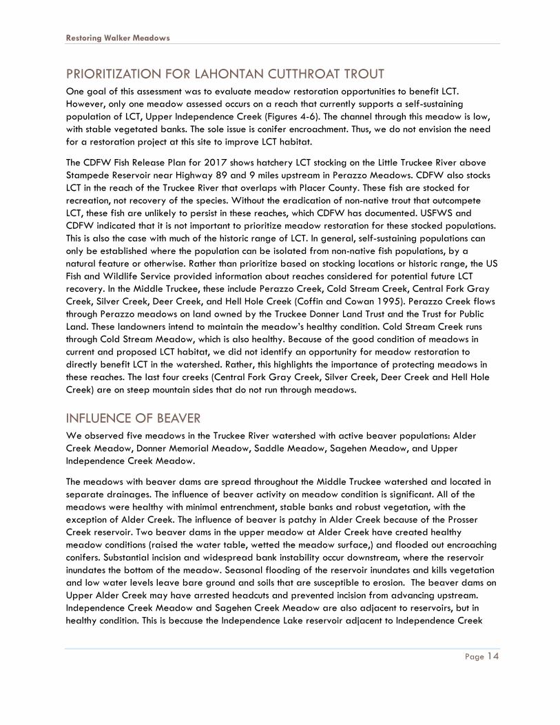
We observed five meadows in the Truckee River watershed with active beaver populations: Alder
Creek Meadow, Donner Memorial Meadow, Saddle Meadow, Sagehen Meadow, and Upper
Independence Creek Meadow.
The meadows with beaver dams are spread throughout the Middle Truckee watershed and located in
separate drainages. The influence of beaver activity on meadow condition is significant. All of the
meadows were healthy with minimal entrenchment, stable banks and robust vegetation, with the
exception of Alder Creek. The influence of beaver is patchy in Alder Creek because of the Prosser
Creek reservoir. Two beaver dams in the upper meadow at Alder Creek have created healthy
meadow conditions (raised the water table, wetted the meadow surface,) and flooded out encroaching
conifers. Substantial incision and widespread bank instability occur downstream, where the reservoir
inundates the bottom of the meadow. Seasonal flooding of the reservoir inundates and kills vegetation
and low water levels leave bare ground and soils that are susceptible to erosion. The beaver dams on
Upper Alder Creek may have arrested headcuts and prevented incision from advancing upstream.
Independence Creek Meadow and Sagehen Creek Meadow are also adjacent to reservoirs, but in
healthy condition. This is because the Independence Lake reservoir adjacent to Independence Creek
Restoring Walker Meadows
Page 15
Meadow is not used for water supply, and Sagehen Creek Meadow is not close enough to Stampede
reservoir be affected by rising and lowering waters.
FIGURE 7 ALDER CREEK WITH DEAD CONIFERS (LEFT). BEAVER DAM IN DONNER MEMORIAL MEADOW (RIGHT)
CONCLUSION
Six meadows were identified as top priority by the Truckee River Watershed stakeholder group: Alder
Creek Meadow, Hoke Valley Meadow, Dog Valley Meadow, Sardine Valley Meadow, Lower Lacey
Meadow, and Secret Meadow. These priorities include the meadows with the poorest channel
conditions as well as Secret Meadow, which was identified because it has a large headcut at the
bottom threatening the entire meadow area.
Restoring Walker Meadows
Page 16
TRUCKEE RIVER MEADOWS ASSESSMENT DATA
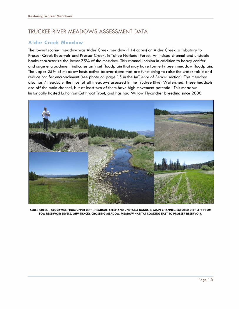
Alder Creek Meadow
The lowest scoring meadow was Alder Creek meadow (114 acres) on Alder Creek, a tributary to
Prosser Creek Reservoir and Prosser Creek, in Tahoe National Forest. An incised channel and unstable
banks characterize the lower 75% of the meadow. This channel incision in addition to heavy conifer
and sage encroachment indicates an inset floodplain that may have formerly been meadow floodplain.
The upper 25% of meadow hosts active beaver dams that are functioning to raise the water table and
reduce conifer encroachment (see photo on page 15 in the Influence of Beaver section). This meadow
also has 7 headcuts- the most of all meadows assessed in the Truckee River Watershed. These headcuts
are off the main channel, but at least two of them have high movement potential. This meadow
historically hosted Lahontan Cutthroat Trout, and has had Willow Flycatcher breeding since 2000.
ALDER CREEK – CLOCKWISE FROM UPPER LEFT - HEADCUT, STEEP AND UNSTABLE BANKS IN MAIN CHANNEL, EXPOSED DIRT LEFT FROM
LOW RESERVOIR LEVELS, OHV TRACKS CROSSING MEADOW, MEADOW HABITAT LOOKING EAST TO PROSSER RESERVOIR.
Restoring Walker Meadows
Page 17
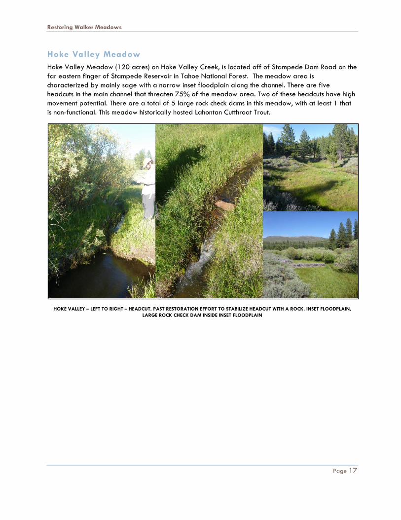
Hoke Valley Meadow
Hoke Valley Meadow (120 acres) on Hoke Valley Creek, is located off of Stampede Dam Road on the
far eastern finger of Stampede Reservoir in Tahoe National Forest. The meadow area is
characterized by mainly sage with a narrow inset floodplain along the channel. There are five
headcuts in the main channel that threaten 75% of the meadow area. Two of these headcuts have high
movement potential. There are a total of 5 large rock check dams in this meadow, with at least 1 that
is non-functional. This meadow historically hosted Lahontan Cutthroat Trout.
HOKE VALLEY – LEFT TO RIGHT – HEADCUT, PAST RESTORATION EFFORT TO STABILIZE HEADCUT WITH A ROCK, INSET FLOODPLAIN,
LARGE ROCK CHECK DAM INSIDE INSET FLOODPLAIN
Restoring Walker Meadows
Page 18
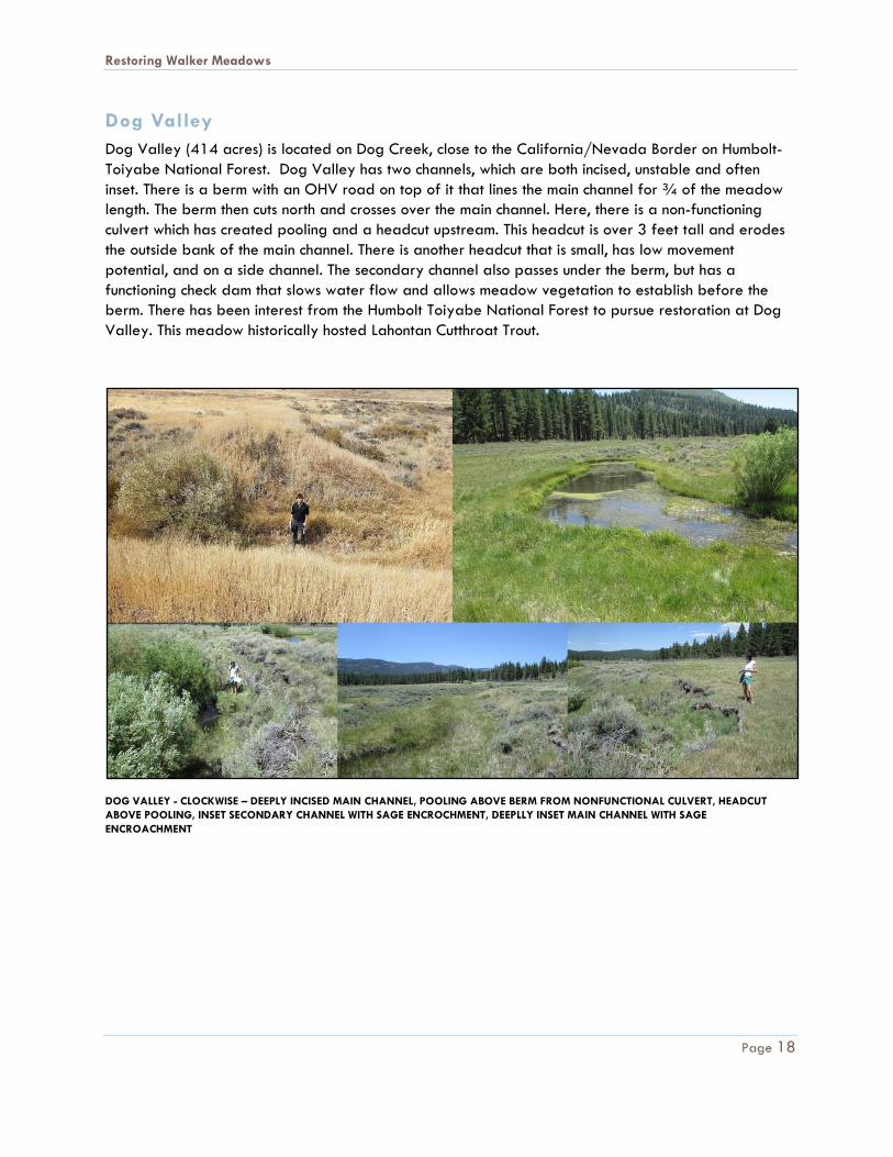
Dog Valley
Dog Valley (414 acres) is located on Dog Creek, close to the California/Nevada Border on Humbolt-
Toiyabe National Forest. Dog Valley has two channels, which are both incised, unstable and often
inset. There is a berm with an OHV road on top of it that lines the main channel for ¾ of the meadow
length. The berm then cuts north and crosses over the main channel. Here, there is a non-functioning
culvert which has created pooling and a headcut upstream. This headcut is over 3 feet tall and erodes
the outside bank of the main channel. There is another headcut that is small, has low movement
potential, and on a side channel. The secondary channel also passes under the berm, but has a
functioning check dam that slows water flow and allows meadow vegetation to establish before the
berm. There has been interest from the Humbolt Toiyabe National Forest to pursue restoration at Dog
Valley. This meadow historically hosted Lahontan Cutthroat Trout.
DOG VALLEY - CLOCKWISE – DEEPLY INCISED MAIN CHANNEL, POOLING ABOVE BERM FROM NONFUNCTIONAL CULVERT, HEADCUT
ABOVE POOLING, INSET SECONDARY CHANNEL WITH SAGE ENCROCHMENT, DEEPLLY INSET MAIN CHANNEL WITH SAGE
ENCROACHMENT
Restoring Walker Meadows
Page 19
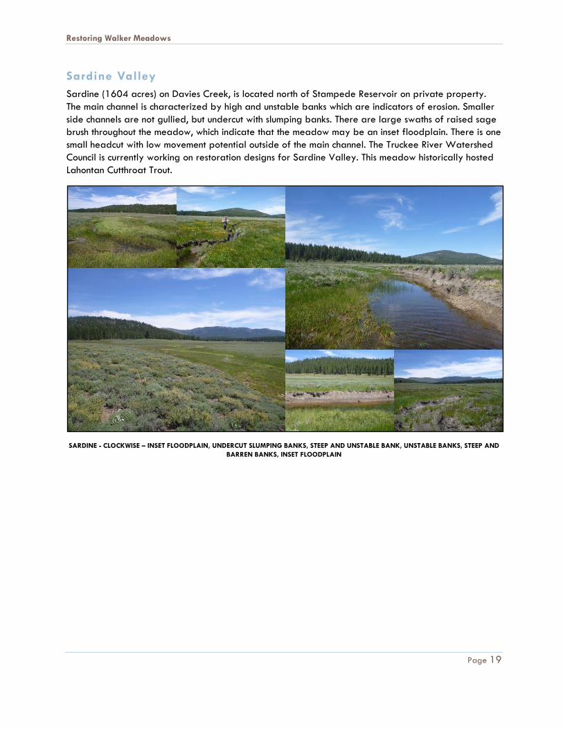
Sardine Valley
Sardine (1604 acres) on Davies Creek, is located north of Stampede Reservoir on private property.
The main channel is characterized by high and unstable banks which are indicators of erosion. Smaller
side channels are not gullied, but undercut with slumping banks. There are large swaths of raised sage
brush throughout the meadow, which indicate that the meadow may be an inset floodplain. There is one
small headcut with low movement potential outside of the main channel. The Truckee River Watershed
Council is currently working on restoration designs for Sardine Valley. This meadow historically hosted
Lahontan Cutthroat Trout.
SARDINE - CLOCKWISE – INSET FLOODPLAIN, UNDERCUT SLUMPING BANKS, STEEP AND UNSTABLE BANK, UNSTABLE BANKS, STEEP AND
BARREN BANKS, INSET FLOODPLAIN
Restoring Walker Meadows
Page 20
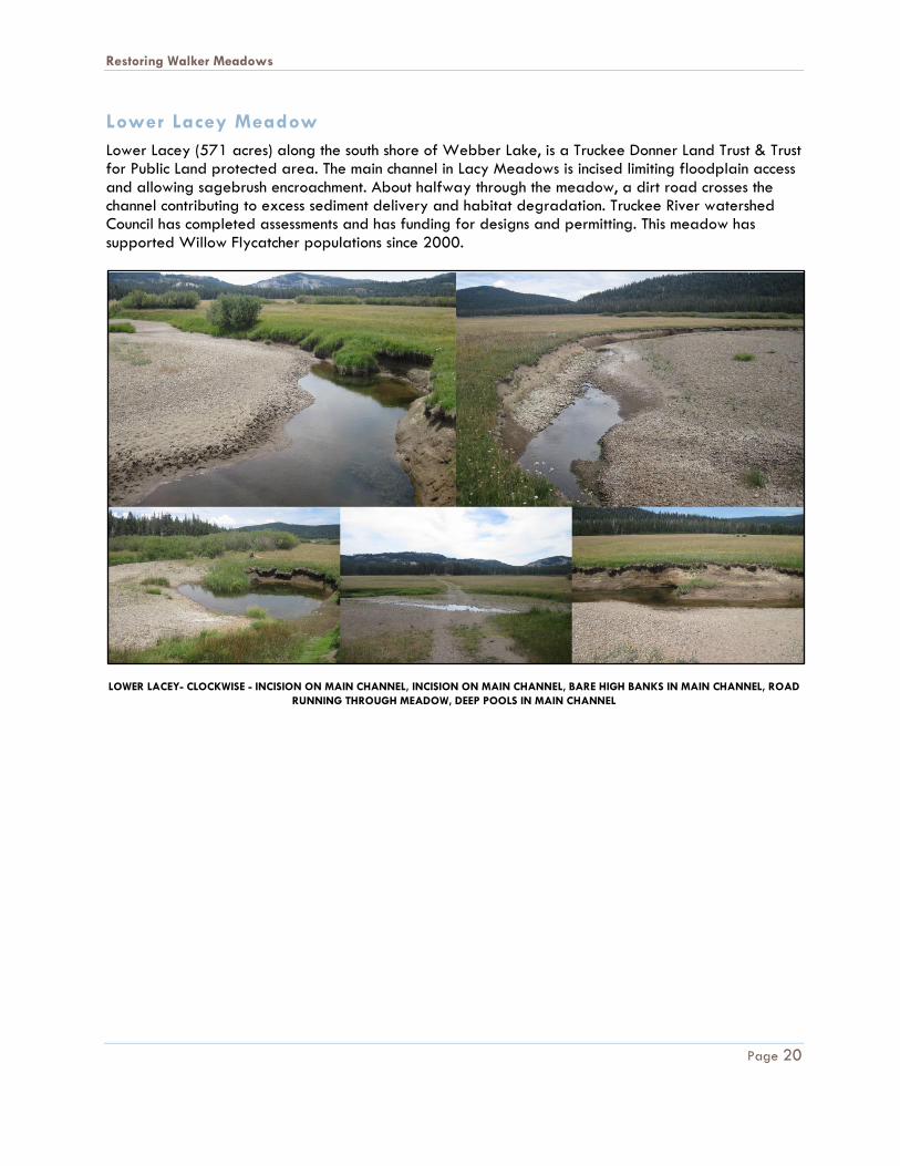
Lower Lacey Meadow
Lower Lacey (571 acres) along the south shore of Webber Lake, is a Truckee Donner Land Trust & Trust for Public Land protected area. The main channel in Lacy Meadows is incised limiting floodplain access and allowing sagebrush encroachment. About halfway through the meadow, a dirt road crosses the channel contributing to excess sediment delivery and habitat degradation. Truckee River watershed Council has completed assessments and has funding for designs and permitting. This meadow has supported Willow Flycatcher populations since 2000.
LOWER LACEY- CLOCKWISE - INCISION ON MAIN CHANNEL, INCISION ON MAIN CHANNEL, BARE HIGH BANKS IN MAIN CHANNEL, ROAD
RUNNING THROUGH MEADOW, DEEP POOLS IN MAIN CHANNEL
Restoring Walker Meadows
Page 21
Secret Meadow
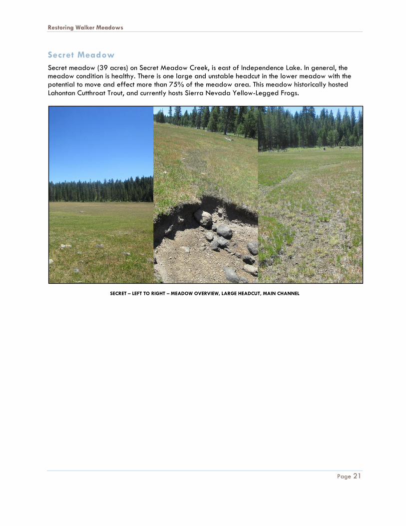
Secret meadow (39 acres) on Secret Meadow Creek, is east of Independence Lake. In general, the meadow condition is healthy. There is one large and unstable headcut in the lower meadow with the potential to move and effect more than 75% of the meadow area. This meadow historically hosted
Lahontan Cutthroat Trout, and currently hosts Sierra Nevada Yellow-Legged Frogs.
SECRET – LEFT TO RIGHT – MEADOW OVERVIEW, LARGE HEADCUT, MAIN CHANNEL
Restoring Walker Meadows
Page 22
Stampede Dam Road Meadow
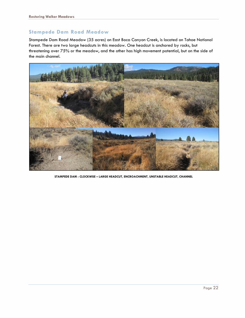
Stampede Dam Road Meadow (35 acres) on East Boca Canyon Creek, is located on Tahoe National
Forest. There are two large headcuts in this meadow. One headcut is anchored by rocks, but
threatening over 75% or the meadow, and the other has high movement potential, but on the side of
the main channel.
STAMPEDE DAM - CLOCKWISE – LARGE HEADCUT, ENCROACHMENT, UNSTABLE HEADCUT, CHANNEL
Restoring Walker Meadows
Page 23
Russel Valley- Dry Creek
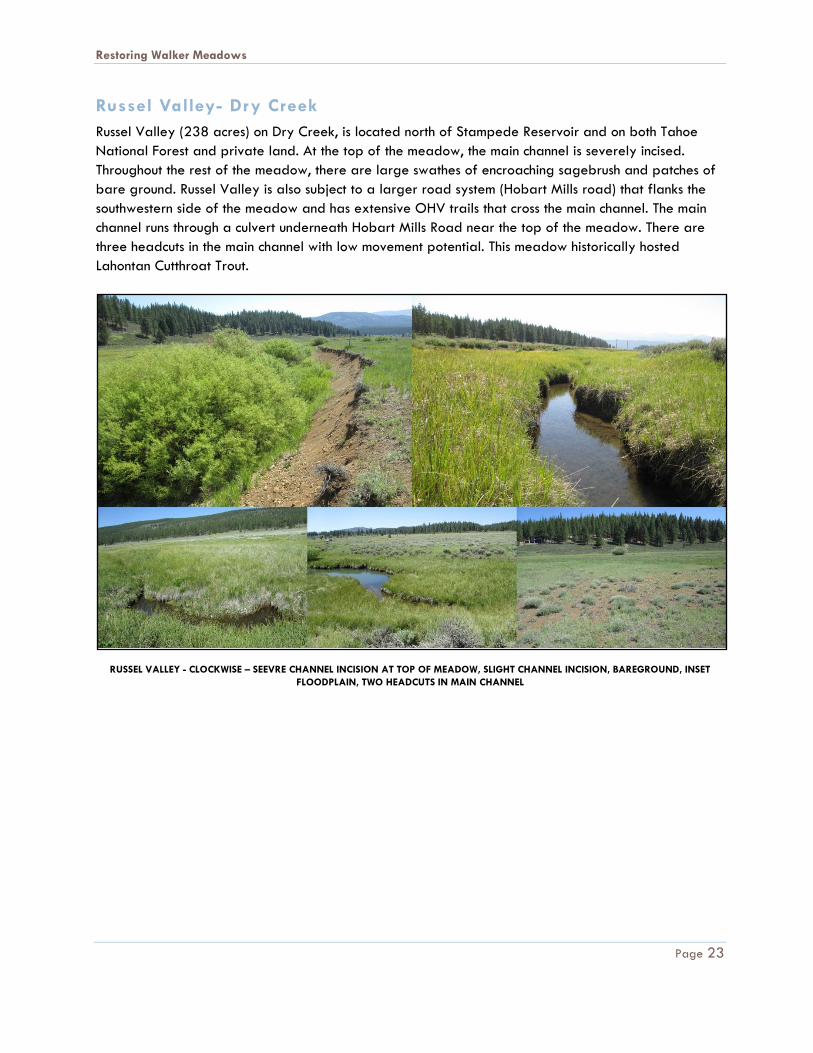
Russel Valley (238 acres) on Dry Creek, is located north of Stampede Reservoir and on both Tahoe
National Forest and private land. At the top of the meadow, the main channel is severely incised.
Throughout the rest of the meadow, there are large swathes of encroaching sagebrush and patches of
bare ground. Russel Valley is also subject to a larger road system (Hobart Mills road) that flanks the
southwestern side of the meadow and has extensive OHV trails that cross the main channel. The main
channel runs through a culvert underneath Hobart Mills Road near the top of the meadow. There are
three headcuts in the main channel with low movement potential. This meadow historically hosted
Lahontan Cutthroat Trout.
RUSSEL VALLEY - CLOCKWISE – SEEVRE CHANNEL INCISION AT TOP OF MEADOW, SLIGHT CHANNEL INCISION, BAREGROUND, INSET
FLOODPLAIN, TWO HEADCUTS IN MAIN CHANNEL
Restoring Walker Meadows
Page 24
Stampede Meadow
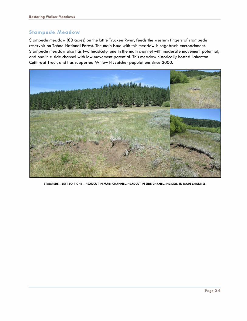
Stampede meadow (80 acres) on the Little Truckee River, feeds the western fingers of stampede
reservoir on Tahoe National Forest. The main issue with this meadow is sagebrush encroachment.
Stampede meadow also has two headcuts- one in the main channel with moderate movement potential,
and one in a side channel with low movement potential. This meadow historically hosted Lahontan
Cutthroat Trout, and has supported Willow Flycatcher populations since 2000.
STAMPEDE – LEFT TO RIGHT – HEADCUT IN MAIN CHANNEL, HEADCUT IN SIDE CHANEL, INCISION IN MAIN CHANNEL
Restoring Walker Meadows
Page 25
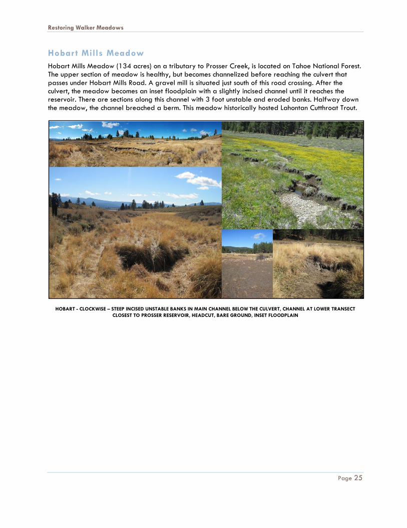
Hobar t Mills Meadow
Hobart Mills Meadow (134 acres) on a tributary to Prosser Creek, is located on Tahoe National Forest. The upper section of meadow is healthy, but becomes channelized before reaching the culvert that passes under Hobart Mills Road. A gravel mill is situated just south of this road crossing. After the culvert, the meadow becomes an inset floodplain with a slightly incised channel until it reaches the reservoir. There are sections along this channel with 3 foot unstable and eroded banks. Halfway down the meadow, the channel breached a berm. This meadow historically hosted Lahontan Cutthroat Trout.
HOBART - CLOCKWISE – STEEP INCISED UNSTABLE BANKS IN MAIN CHANNEL BELOW THE CULVERT, CHANNEL AT LOWER TRANSECT
CLOSEST TO PROSSER RESERVOIR, HEADCUT, BARE GROUND, INSET FLOODPLAIN
Restoring Walker Meadows
Page 26
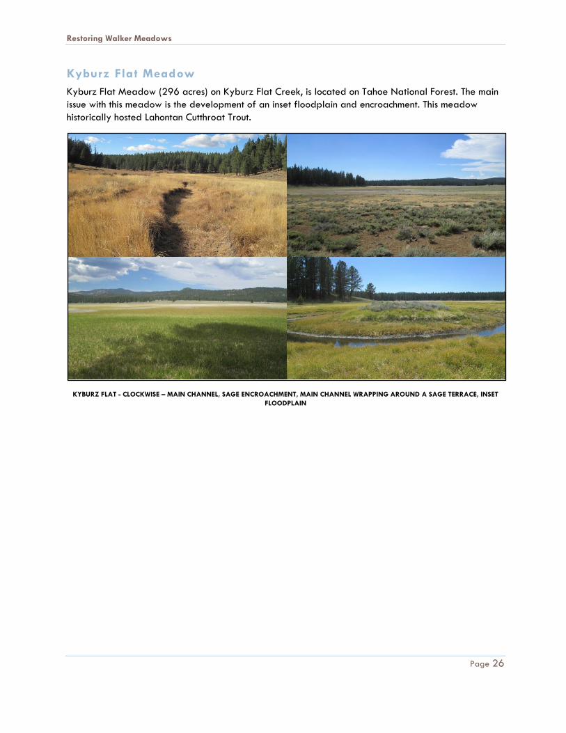
Kyburz Flat Meadow
Kyburz Flat Meadow (296 acres) on Kyburz Flat Creek, is located on Tahoe National Forest. The main
issue with this meadow is the development of an inset floodplain and encroachment. This meadow
historically hosted Lahontan Cutthroat Trout.
KYBURZ FLAT - CLOCKWISE – MAIN CHANNEL, SAGE ENCROACHMENT, MAIN CHANNEL WRAPPING AROUND A SAGE TERRACE, INSET
FLOODPLAIN
Restoring Walker Meadows
Page 27
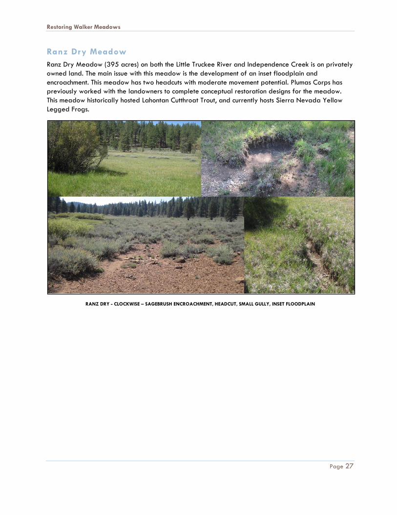
Ranz Dry Meadow
Ranz Dry Meadow (395 acres) on both the Little Truckee River and Independence Creek is on privately
owned land. The main issue with this meadow is the development of an inset floodplain and
encroachment. This meadow has two headcuts with moderate movement potential. Plumas Corps has
previously worked with the landowners to complete conceptual restoration designs for the meadow.
This meadow historically hosted Lahontan Cutthroat Trout, and currently hosts Sierra Nevada Yellow
Legged Frogs.
RANZ DRY - CLOCKWISE – SAGEBRUSH ENCROACHMENT, HEADCUT, SMALL GULLY, INSET FLOODPLAIN
Restoring Walker Meadows
Page 28
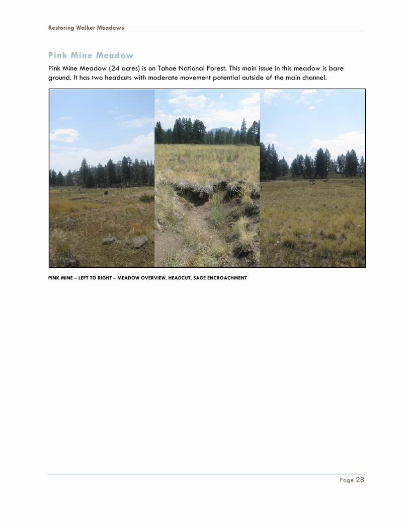
Pink Mine Meadow
Pink Mine Meadow (24 acres) is on Tahoe National Forest. This main issue in this meadow is bare
ground. It has two headcuts with moderate movement potential outside of the main channel.
PINK MINE – LEFT TO RIGHT – MEADOW OVERVIEW, HEADCUT, SAGE ENCROACHMENT
Restoring Walker Meadows
Page 29
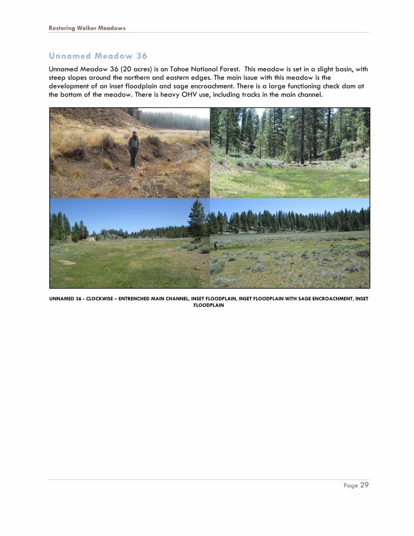
Unnamed Meadow 36
Unnamed Meadow 36 (20 acres) is on Tahoe National Forest. This meadow is set in a slight basin, with steep slopes around the northern and eastern edges. The main issue with this meadow is the development of an inset floodplain and sage encroachment. There is a large functioning check dam at the bottom of the meadow. There is heavy OHV use, including tracks in the main channel.
UNNAMED 36 - CLOCKWISE – ENTRENCHED MAIN CHANNEL, INSET FLOODPLAIN, INSET FLOODPLAIN WITH SAGE ENCROACHMENT, INSET
FLOODPLAIN
Restoring Walker Meadows
Page 30
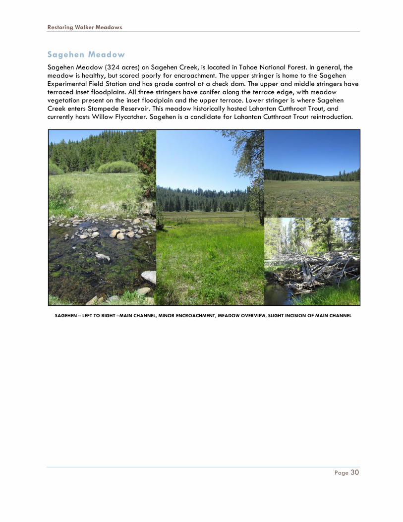
Sagehen Meadow
Sagehen Meadow (324 acres) on Sagehen Creek, is located in Tahoe National Forest. In general, the meadow is healthy, but scored poorly for encroachment. The upper stringer is home to the Sagehen Experimental Field Station and has grade control at a check dam. The upper and middle stringers have terraced inset floodplains. All three stringers have conifer along the terrace edge, with meadow vegetation present on the inset floodplain and the upper terrace. Lower stringer is where Sagehen Creek enters Stampede Reservoir. This meadow historically hosted Lahontan Cutthroat Trout, and currently hosts Willow Flycatcher. Sagehen is a candidate for Lahontan Cutthroat Trout reintroduction.
SAGEHEN – LEFT TO RIGHT –MAIN CHANNEL, MINOR ENCROACHMENT, MEADOW OVERVIEW, SLIGHT INCISION OF MAIN CHANNEL
Restoring Walker Meadows
Page 31
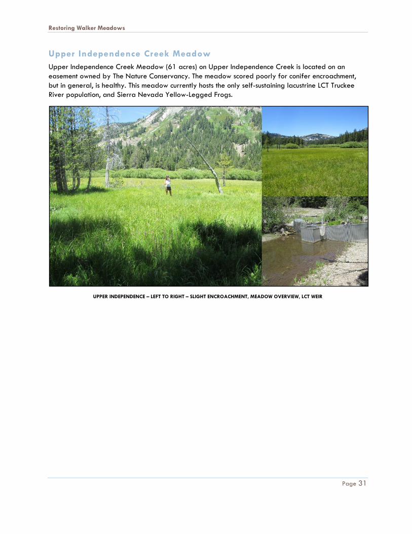
Upper Independence Creek Meadow
Upper Independence Creek Meadow (61 acres) on Upper Independence Creek is located on an
easement owned by The Nature Conservancy. The meadow scored poorly for conifer encroachment,
but in general, is healthy. This meadow currently hosts the only self-sustaining lacustrine LCT Truckee
River population, and Sierra Nevada Yellow-Legged Frogs.
UPPER INDEPENDENCE – LEFT TO RIGHT – SLIGHT ENCROACHMENT, MEADOW OVERVIEW, LCT WEIR
Restoring Walker Meadows
Page 32
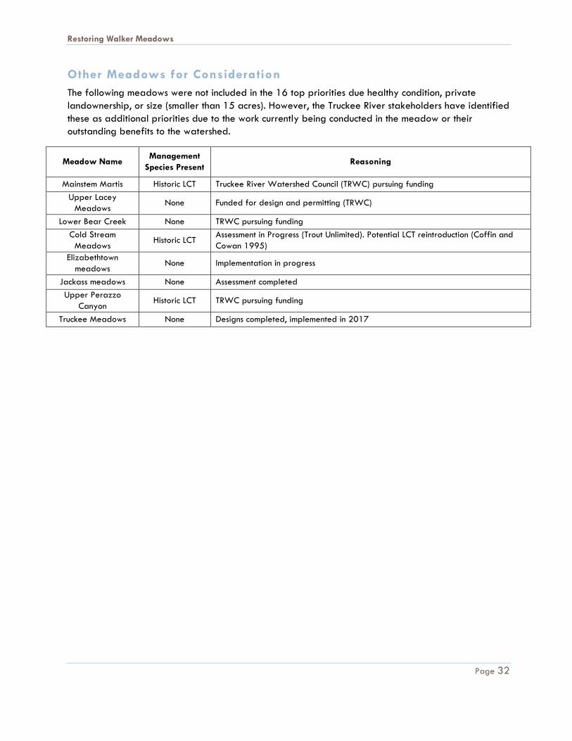
Other Meadows for Consideration
The following meadows were not included in the 16 top priorities due healthy condition, private
landownership, or size (smaller than 15 acres). However, the Truckee River stakeholders have identified
these as additional priorities due to the work currently being conducted in the meadow or their
outstanding benefits to the watershed.
Meadow Name Management
Species Present Reasoning
Mainstem Martis Historic LCT Truckee River Watershed Council (TRWC) pursuing funding
Upper Lacey
Meadows None Funded for design and permitting (TRWC)
Lower Bear Creek None TRWC pursuing funding
Cold Stream
Meadows Historic LCT
Assessment in Progress (Trout Unlimited). Potential LCT reintroduction (Coffin and
Cowan 1995)
Elizabethtown
meadows None Implementation in progress
Jackass meadows None Assessment completed
Upper Perazzo
Canyon Historic LCT TRWC pursuing funding
Truckee Meadows None Designs completed, implemented in 2017
Restoring Walker Meadows
Page 33
References
American Rivers. 2012. “Evaluating and Prioritizing Meadow Restoration in the Sierra.” http://www.americanrivers.org/assets/pdfs/meadow-restoraton/evaluating-and-prioritizing-meadow-restoration-in-the-sierra.pdf?422fcb.
Barbour, M.T., J. Gerritsen, BD Snyder, and JB Stribling. 1999. “Rapid Bioassessment Protocols for Use in Streams and Wadeable Rivers.” USEPA, Washington.
City of Reno. n.d. “Truckee River Watershed | City of Reno.” Accessed February 28, 2018. https://www.reno.gov/government/departments/public-works/regional-stormwater-quality-management-program/watershed.
Coffin, Patrick D., and William F. Cowan. 1995. “Recovery Plan for the Lahontan Cutthroat Trout.” U.S. Fish and Wildlife Service Region 1.
Helen Loffland, Rodney Siegel, Ryan Burnett, Brent Campos, Chris Sterner, and Tina Marks. 2014. “Assessing Willow Flycatcher Population Size and Distribution to Inform Meadow Restoration in the Sierra Nevada and Southern Cascades.” The Institute for Bird Populations, Point Reyes Station, California. https://www.birdpop.org/docs/pubs/Loffland_et_al_2014_Assessing_WIFL_Population_Size_and_Distribution_to_Inform_Meadow_Restoration.pdf.
National Park Service. n.d. “Nevada: Derby Diversion Dam (U.S. National Park Service).” Accessed February 28, 2018. https://www.nps.gov/articles/nevada-derby-diversion-dam.htm.
NFWF. 2010. “Business Plan: Sierra Nevada Meadow Restoration.” National Fish and Wildlife Foundation. http://www.nfwf.org/Content/ContentFolders/NationalFishandWildlifeFoundation/GrantPrograms/Keystones/WildlifeandHabitat/Sierra_Meadow_Restoration_business_plan.pdf.
US Department of the Interior. 2009. “Independence Lake Land Acquisition.” USDI-BLM, USDA-Forest Service, and USDA-NRCS. 1998. “A User Guide to Assessing Proper
Functioning Condition and the Supporting Science for Lotic Areas Tech. Rep. 1737‐15.”
Restoring Walker Meadows
Page 34
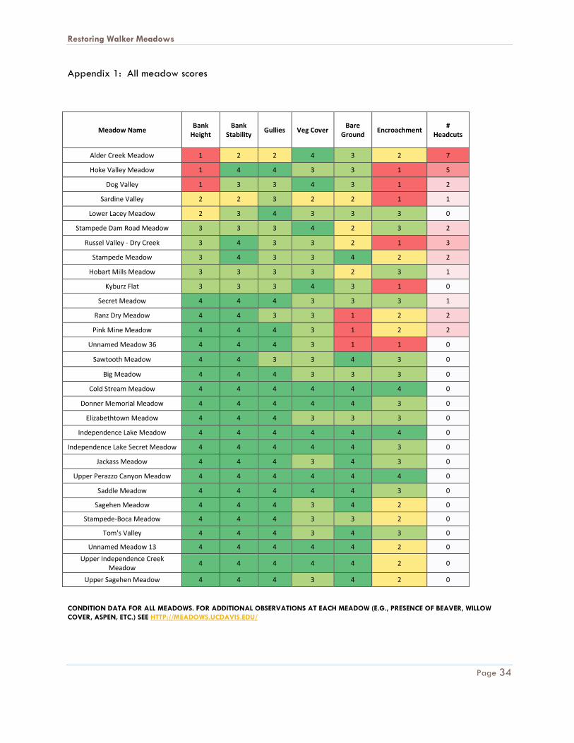
Appendix 1: All meadow scores
Meadow Name Bank
Height Bank
Stability Gullies Veg Cover
Bare Ground
Encroachment #
Headcuts
Alder Creek Meadow 1 2 2 4 3 2 7
Hoke Valley Meadow 1 4 4 3 3 1 5
Dog Valley 1 3 3 4 3 1 2
Sardine Valley 2 2 3 2 2 1 1
Lower Lacey Meadow 2 3 4 3 3 3 0
Stampede Dam Road Meadow 3 3 3 4 2 3 2
Russel Valley - Dry Creek 3 4 3 3 2 1 3
Stampede Meadow 3 4 3 3 4 2 2
Hobart Mills Meadow 3 3 3 3 2 3 1
Kyburz Flat 3 3 3 4 3 1 0
Secret Meadow 4 4 4 3 3 3 1
Ranz Dry Meadow 4 4 3 3 1 2 2
Pink Mine Meadow 4 4 4 3 1 2 2
Unnamed Meadow 36 4 4 4 3 1 1 0
Sawtooth Meadow 4 4 3 3 4 3 0
Big Meadow 4 4 4 3 3 3 0
Cold Stream Meadow 4 4 4 4 4 4 0
Donner Memorial Meadow 4 4 4 4 4 3 0
Elizabethtown Meadow 4 4 4 3 3 3 0
Independence Lake Meadow 4 4 4 4 4 4 0
Independence Lake Secret Meadow 4 4 4 4 4 3 0
Jackass Meadow 4 4 4 3 4 3 0
Upper Perazzo Canyon Meadow 4 4 4 4 4 4 0
Saddle Meadow 4 4 4 4 4 3 0
Sagehen Meadow 4 4 4 3 4 2 0
Stampede-Boca Meadow 4 4 4 3 3 2 0
Tom's Valley 4 4 4 3 4 3 0
Unnamed Meadow 13 4 4 4 4 4 2 0
Upper Independence Creek Meadow
4 4 4 4 4 2 0
Upper Sagehen Meadow 4 4 4 3 4 2 0
CONDITION DATA FOR ALL MEADOWS. FOR ADDITIONAL OBSERVATIONS AT EACH MEADOW (E.G., PRESENCE OF BEAVER, WILLOW
COVER, ASPEN, ETC.) SEE HTTP://MEADOWS.UCDAVIS.EDU/