Restoration Plan and Environmental Assessment · 2017-11-15 · ES. 1 INTRODUCTION AND PURPOSE This...
77
PREPARED BY: United States Department of the Interior (represented by the Fish and Wildlife Service and Bureau of Land Management) United States Department of Agriculture (represented by the Forest Service) State of New Mexico (represented by the Office of Natural Resources Trustee) WITH ASSISTANCE FROM: Industrial Economics, Incorporated Restoration Plan and Environmental Assessment Questa Mine Site Questa, New Mexico DRAFT | November 2017 Photo credit: Pamela Herrera-Olivas, BLM.
Transcript of Restoration Plan and Environmental Assessment · 2017-11-15 · ES. 1 INTRODUCTION AND PURPOSE This...

PREPARED BY:
United States Department of the Interior
(represented by the Fish and Wildlife Service and Bureau of Land Management)
United States Department of Agriculture
(represented by the Forest Service)
State of New Mexico
(represented by the Office of Natural Resources Trustee)
WITH ASSISTANCE FROM:
Industrial Economics, Incorporated
Restoration Plan and Environmental Assessment
Questa Mine Site
Questa, New Mexico
DRAFT | November 2017
Photo credit:
Pamela Herrera-Olivas, BLM.

This page intentionally left blank.

Draft Questa Mine Site RP/EA; November 2017
i
TABLE OF CONTENTS
EXECUTIVE SUMMARY ES.1 Introduction and Purpose vii ES.2 Preferred Restoration Alternative vii ES.3 Public Involvement viii
CHAPTER 1 | INTRODUCTION 1.1 Site Background 1 1.2 CERCLA and the Designation of Natural Resource Trustees 2 1.3 Purpose and Need 4 1.4 Compliance with Other Authorities 5 1.5 Public Participation 5 1.6 Administrative Record 6 1.7 Organization of this Document 7
CHAPTER 2 | QUESTA MINE SITE AREA, REMEDY, AND NATURAL RESOURCE
DAMAGE ASSESSMENT AND RESTORATION 2.1 Red River Watershed 8 2.2 Summary of Site History and Remediation 10
2.2.1 Contaminated Mine Waste Surface Deposits 10 2.2.2 Spills of Tailings Slurry 10 2.2.3 Seepage from the Tailings Ponds 10 2.2.4 Remediation 10
2.3 Relationship of NRDA to Remedial Activities 12 2.4 Natural Resource Damage Assessment and Restoration 13
2.4.1 Natural Resource Damage Assessment and Restoration Activities at this Site 13 2.4.2 Natural Resources Damages Settlement 14
CHAPTER 3 | AFFECTED ENVIRONMENT 3.1 Physical Environment 17 3.2 Biological Environment 18
3.2.1 Endangered and Threatened Species 20 3.3 Landscape Scale Ecological Stressors 21 3.4 SocioEconomic Resources 21
3.4.1 Environmental Justice 21

Draft Questa Mine Site RP/EA; November 2017
ii
3.5 Cultural and Historic Resources 22 3.6 Summary 23
CHAPTER 4 | NATURAL RESOURCE INJURIES AND SERVICE LOSSES 4.1 Approach to Injury Quantification and Restoration Scaling 24 4.2 Natural Resource Injuries 25
4.2.1 Identification of Potentially Injured Resources 25 4.2.2 Injury Quantification 25
CHAPTER 5 | RESTORATION PROJECT IDENTIFICATION, SCREENING, AND
EVALUATION PROCESS 5.1 Restoration Objectives 27 5.2 Soliciting and Formulating a Wide Range of Restoration Projects 27 5.3 Screening and Evaluation 28
5.3.1 Screening Criteria 28 5.3.2 Evaluation Criteria 29
5.4 Projects Considered but Not Evaluated Further 30
CHAPTER 6 | TRUSTEES’ PREFERRED RESTORATION ALTERNATIVE AND
EVALUATION OF THE PROJECTS 6.1 Summary of Proposed Projects and the Preferred Restoration Alternative 31 6.2 Trustee Evaluation of Tier 1 Restoration Projects 34
6.2.1 Aquatic Habitat Restoration in the Red River on FS Lands 34 6.2.2 Municipal Sanitary Sewer System Improvements for the Village of Questa 36 6.2.3 New Municipal Water Supply Well for the Village of Questa 37 6.2.4 Red River Aquatic Habitat Restoration within the Village of Questa 40 6.2.5 Restoration of the Midnight Meadows Wetland 42
6.3 Trustee Evaluation of Tier 2 Projects 44 6.3.1 South Ditch Diversion Structure 44
CHAPTER 7 | ENVIRONMENTAL ASSESSMENT 7.1 Introduction 46 7.2 Alternatives Evaluated under NEPA 46
7.2.1 No Action Alternative 46 7.2.2 Preferred Restoration Alternative 47
7.3 Scope of the Assessment of Environmental Consequences 47 7.4 Environmental Consequences 48
7.4.1 No Action Alternative 48 7.4.2 Preferred Restoration Alternative 49
7.5 Summary of the Preferred Restoration Alternative 52
CHAPTER 8 | MONITORING

Draft Questa Mine Site RP/EA; November 2017
iii
8.1 Questa Mine Site NRDA Restoration Monitoring Framework 55 8.2 Adaptive Management 56
REFERENCES
APPENDIX A. AGENCIES, ORGANIZATIONS, AND PARTIES CONSULTED
APPENDIX B. DEFINITIONS OF NEPA TERMS

Draft Questa Mine Site RP/EA; November 2017
iv
LIST OF TABLES AND FIGURES
Table ES-1 Restoration Projects Included in the Preferred Restoration Alternative vii
Figure ES-2 Locations of Projects Included in the Preferred Restoration Alternative ix
Figure 1-1 Map of the Site 3
Figure 2-1 Previously Completed Restoration Projects in the Red River Watershed 9
Figure 2-2 Phases of the Natural Resource Damage Assessment Process 13
Table 3-1 Plant Communities Present in the Red River Watershed, According to Elevation 19
Table 3-2 Migratory Birds of Particular Conservation Concern that May Be Potentially Affected by Restoration Activities 20
Table 3-3 Census Data for Race in the Village of Questa 22
Table 3-4 Listed Properties in Red River on the National Register of Historic Places 23
Table 5-1 Screening Criteria for Proposed Restoration Projects 29
Table 5-2 Evaluation Criteria for Proposed Restoration Projects 30
Table 6-1 Results of the Trustees’ Restoration Project Screening and Evaluation 32
Figure 6-1 Locations of Projects Included in the Preferred Restoration Alternative 33
Table 7-1 Summary of Environmental Consequences 47
Table 7-2 Compliance with NEPA and Other Potentially Applicable Laws 53
Table 8-1 General Monitoring Framework 56

Draft Questa Mine Site RP/EA; November 2017
v
LIST OF ACRONYMS
AO Authorized Official
AOC Administrative Order on Consent
BLM United States Bureau of Land Management
C.F.R. Code of Federal Regulations
CEQ Council on Environmental Quality
CERCLA Comprehensive Environmental Response, Compensation, and Liability Act
CMI Chevron Mining, Inc.
CWA Clean Water Act
DOI United States Department of the Interior
EA Environmental Assessment
EIS Environmental Impact Statement
EPA United States Environmental Protection Agency
FONSI Finding of No Significant Impact
FS United States Forest Service
FWS United States Fish and Wildlife Service
gpm gallons per minute
HEA habitat equivalency analysis
NEPA National Environmental Policy Act
NHPA National Historic Preservation Act
NMAC New Mexico Administrative Code
NMED New Mexico Environment Department
NMSA New Mexico Statutes Annotated
NPL National Priorities List
NRDA Natural Resource Damage Assessment
ONRT State of New Mexico Office of Natural Resources Trustee

Draft Questa Mine Site RP/EA; November 2017
vi
PRP potentially responsible party
REA resource equivalency analysis
RFP Request for Proposals
RI/FS Remedial Investigation/Feasibility Study
ROD Record of Decision
RP Restoration Plan
RP/EA Restoration Plan and Environmental Assessment
U.S. United States
U.S.C. United States Code

Draft Questa Mine Site RP/EA; November 2017
vii
EXECUTIVE SUMMARY
ES.1 INTRODUCTION AND PURPOSE
This draft Restoration Plan and Environmental Assessment (RP/EA) has been prepared by state and Federal natural resource trustees as part of the Natural Resource Damage Assessment (NRDA) for the Questa Mine Site (the Site) located near Questa, New Mexico. The designated natural resource trustee agencies (collectively, the Trustees) involved in the development of this plan and the Questa Mine Site NRDA are: the State of New Mexico Office of Natural Resources Trustee (ONRT), the United States Department of the Interior (DOI) represented by the U.S. Fish and Wildlife Service (FWS) and the Bureau of Land Management (BLM), and the United States Department of Agriculture (USDA) Forest Service (FS). The Trustees are acting under Section 107(f) of the Comprehensive Environmental Response, Compensation, and Liability Act (CERCLA), Clean Water Act (CWA), and other applicable laws, including Subpart G of the National Contingency Plan and applicable state laws (New Mexico Statutes Annotated [NMSA] 1978), §§ 75-7-1 to -45 (1993).
Each Trustee is authorized to act on behalf of the public to evaluate potential injuries to natural resources and associated losses of services resulting from releases of hazardous substances from the Site. The Trustees use monetary damages recovered as compensation for these injuries (i) to restore, replace, or acquire the equivalent of the injured natural resources, (ii) to compensate for loss of natural resource services resulting from injuries, and (iii) to reimburse the Trustees for reasonable costs of assessing the injuries.
The purpose of this draft RP/EA is to inform members of the public and solicit comments on the restoration actions proposed by the Trustees to compensate for natural resource injuries and associated lost services resulting from hazardous substance releases from the Site (i.e., describe how the Trustees propose to use the settlement monies to restore natural resource injuries and service losses). This RP/EA also serves as an Environmental Assessment (EA) pursuant to the National Environmental Policy Act (NEPA) (42 U.S.C. § 4321 et seq.) and the regulations guiding its implementation at Title 40 of the Code of Federal Regulations (C.F.R.) § 1500 (et seq.). This plan describes the purpose and need for the proposed restoration actions, the restoration alternatives considered (including a No Action Alternative), and the potential environmental consequences of the proposed restoration actions.
Consistent with NRDA and NEPA regulations, the Trustees evaluated a number of restoration projects for conducting the type and scale of restoration sufficient to compensate the public for natural resource injuries and service losses. Based on the NRDA and NEPA evaluation, the Trustees identified a Preferred Restoration Alternative (Table ES-1 and Figure ES-2).
ES.2 PREFERRED RESTORATION ALTERNATIVE
The Preferred Restoration Alternative consists of the six restoration projects described in Chapter 6 of this document. Under the Preferred Restoration Alternative, the Trustees would conduct the suite of groundwater and aquatic habitat restoration projects which would address the natural resource injuries

Draft Questa Mine Site RP/EA; November 2017
viii
at the Site by enhancing or protecting riparian and wetland habitats and improving groundwater resources. The Trustees evaluated each proposed restoration project according to restoration screening and evaluation criteria and analyzed the environmental consequences of the restoration projects (or alternatives) subject to NEPA.
The Preferred Restoration Alternative is presented in two tiers (Table ES-1). Tier 1 includes the five projects the Trustees prioritized for funding. Tier 2 includes the South Ditch Diversion Structure, which met the restoration screening criteria and was evaluated further by the Trustees but is not being recommended for funding at this time (due to funding limitations). The Trustees expect to use a variety of mechanisms for project implementation and will select the most appropriate mechanism for each project. The details and agreements will be determined between the Trustees and individual project proponents.
TABLE ES-1 RESTORATION PROJECTS INCLUDED IN THE PREFERRED RESTORATION
ALTERNATIVE
PROJECT NAME* PROJECT TYPE RELATIVE PROJECT COST**
PREFERRED RESTORATION ALTERNATIVE (PROJECTS RECOMMENDED FOR FUNDING)
Tier 1 Preferred Restoration Projects
Aquatic Habitat Restoration in the Red River on FS Lands
River Restoration $
Municipal Sanitary Sewer System Improvements for the Village of Questa
Groundwater Restoration
$$$
New Municipal Water Supply Well for the Village of Questa
Groundwater Restoration $$
Red River Aquatic Habitat Restoration within the Village of Questa (Poor and Fair Sections) River Restoration $$$
Restoration of the Midnight Meadows Wetland Wetland Restoration $$
Tier 2 Preferred Restoration Projects
South Ditch Diversion Structure Diversion & Irrigation
$
*Projects are listed alphabetically by funding category. **Projects associated with the $ symbol are low-cost projects below $200,000; projects associated with the $$ symbol are medium-cost projects between $200,000 and $1,000,000; and projects associated with the $$$ symbol are high-cost projects over $1,000,000.
ES.3 PUBLIC INVOLVEMENT
Public input on the draft RP/EA is described in the regulations and is essential for the Trustees to select appropriate restoration actions to compensate for natural resource injuries and associated lost services. This draft RP/EA is available for review and comment for a period of 30 days. Additional information on public involvement including how to submit comments on this draft RP/EA is provided in Chapter 1. The Trustees will address public comments and will respond to those comments as part of the final RP/EA.

Draft Questa Mine Site RP/EA; November 2017
ix
FIGURE ES-2 LOCATIONS OF PROJECTS INCLUDED IN THE PREFERRED RESTORATION
ALTERNATIVE

Draft Questa Mine Site RP/EA; November 2017
1
CHAPTER 1 | INTRODUCTION
This document was prepared by the Questa Mine Site (the Site) natural resource damage assessment trustees (the Trustees). This document serves as the Trustees’ Restoration Plan (RP), to describe the Trustees proposed restoration projects to compensate the public for the natural resource injuries and associated service losses that resulted from hazardous substance releases at the Site under the Comprehensive Environmental Response, Compensation, and Liability Act (CERCLA); and as an Environmental Assessment (EA), which provides the analysis of environmental consequences of the proposed restoration projects (or alternatives) under the National Environmental Policy Act (NEPA).1 Additional background information on the Site, CERCLA, the Trustees, the purpose and need for restoration, Trustee responsibilities, and public involvement are provided below.
1.1 SITE BACKGROUND
The Site includes inactive molybdenum mine and milling operations currently owned and operated by Chevron Mining, Inc. (CMI) and formerly owned and operated by Molycorp, Inc. The Site is located in steep terrain adjacent to the Red River and approximately 6.4 kilometers (4 miles) east of Questa, New Mexico (Figure 1-1). Active mining and milling operations permanently ceased in June 2014. The Trustees initiated a Natural Resource Damage Assessment (NRDA) to compensate the public for natural resource injuries resulting from releases of hazardous substances from the Site. The Trustees and CMI reached a settlement for natural resource damages which was approved in 2015 (Consent Decree 2015).
For the purposes of the NRDA, the site includes a variety of CMI facilities, such as the underground workings, open pit, waste rock piles, former mill, tailing impoundments, and tailing pipelines, as well as nearby natural resources that were contaminated as a result of Site activities. The tailing impoundments are located west of the Village of Questa, approximately 9.7 kilometers (6 miles) west of the mine and milling facility (Figure 1-1). Tailings were transported from the mine to the tailing impoundments through two slurry pipelines adjacent to the Red River. Hazardous substances released at or from the Site include toxic heavy metals (arsenic, cadmium, chromium, cobalt, copper, lead, silver, and zinc) and sulfuric acid compounds (EPA 2010).2 In addition to these hazardous substances, sulfate, fluoride, and iron were also released as byproducts in acidic seepage (EPA 2010).
The Site was initially proposed for inclusion in the National Priorities List (NPL or “Superfund” list) on May 11, 2000. The proposal for listing followed investigations by the United States (U.S.) Environmental Protection Agency (EPA) and U. S. Bureau of Land Management (BLM) beginning in
1 For the purposes of this document, the terms “restoration projects” and “alternatives” are used interchangeably. 2 Hazardous substances are defined in Section 101 (14) of CERCLA at Title 42 of the United States Code (U.S.C.) (42 U.S.C. § 9601 (14)) and listed in the List of Hazardous and Reportable Quantities (Table 302.4 at Title 40 of the Code of Federal Regulations [C.F.R.] § 302.4).

Draft Questa Mine Site RP/EA; November 2017
2
the early 1980s that documented “major impacts to the Red River due to mining and mining-related activities” (EPA 2002). The EPA and Molycorp, Inc. entered into an Administrative Order on Consent (AOC) for Remedial Investigation/Feasibility Study (RI/FS) on June 9, 2001 (EPA 2010). The RI/FS was conducted in phases from 2001 to 2009. A clean-up remedy was selected based on the RI/FS by the EPA in a Record of Decision (ROD) issued on December 20, 2010. The EPA, with concurrence from the State of New Mexico, re-proposed the site for listing to the NPL in March 2011. The proposal was published in the Federal Register and the Site was added to the NPL on September 16, 2011. The ROD, like the RI/FS, identified clean-up actions for five areas of the Site: 1) the mill area, 2) the mine site area, 3) the tailing facility area, 4) the Red River and associated riparian areas south of the tailing facility area, and 5) Eagle Rock Lake (EPA 2010). As described in greater detail in Chapter 2, these remedial actions, while beneficial, do not themselves restore injured natural resources to their baseline condition or compensate the public for past, present, and future contaminant-related injuries to natural resources.
The remainder of this chapter discusses the relevant regulations and authorities under which the Trustees are conducting the NRDA and this corresponding draft RP/EA, the process and opportunities for public participation, and the administrative record.
1.2 CERCLA AND THE DES IGNATION OF NATURAL RESOURCE TRUSTEES
CERCLA (42 U.S.C. § 9601 et seq.) establishes a liability regime for the release of hazardous substances that injure natural resources and the ecological and human use services those resources provide. Pursuant to CERCLA, designated Federal and state agencies, and federally recognized tribes act as trustees on behalf of the public to assess injuries and plan for restoration to compensate for those injuries. CERCLA further instructs the designated trustees to develop and implement a plan for the restoration, rehabilitation, replacement, or acquisition of the equivalent of injured natural resources under their trusteeship (hereafter collectively referred to as “restoration”). CERCLA defines “natural resources” to include “land, fish, wildlife, biota, air, water, groundwater, drinking water supplies, and other such resources belonging to, managed by, held in trust by, appertaining to, or otherwise controlled by the United States … any state or local government, any foreign government, any tribes, or, if such resources are subject to trust restriction or alienation, any member of an Indian tribe” (42 U.S.C. § 9601(16)). The NRDA regulations, guiding the Trustees, are contained in Chapter 43 of the Code of Federal Regulations, Part 11.

Draft Questa Mine Site RP/EA; November 2017
3
FIGURE 1-1 MAP OF THE SITE (MODIF IED FROM EPA 2010)

Draft Questa Mine Site RP/EA; November 2017
4
Federal agencies are designated as natural resource trustees pursuant to section 107 of CERCLA (42 U.S.C. § 9607(f)(2)(A)), Executive Order 12777, and the National Contingency Plan (40 C.F.R. § 300.600) and state agencies are designated as natural resource trustees by the governors of each state pursuant to section 107 of CERCLA (42 U.S.C. § 9607(f)(2)(B)). For the Questa Mine Site NRDA, the Trustees include:
• The U.S. Department of the Interior (DOI), represented by the U.S. Fish and Wildlife Service (FWS; serving as the lead Federal trustee) and BLM;
• The U.S. Department of Agriculture, represented by the U.S. Forest Service (FS); and, • The State of New Mexico, acting through the Office of Natural Resources Trustee (ONRT),
pursuant to the New Mexico Natural Resources Trustee Act (New Mexico Statutes Annotated [NMSA] 1978, §§ 75-7-1 et seq.).
The Federal Authorized Official (AO) is the DOI official delegated the authority to act on behalf of the Secretary of the Interior to conduct a NRDA and develop a RP. The AO is the Regional Director for the FWS Region 2, and represents the interests of the DOI, including all affected Bureaus.
The Trustees’ overarching goals throughout the NRDA process have been to: 1) assess the natural resource injuries resulting from the release of hazardous substances in and around the Site, and 2) develop and implement a restoration plan to compensate for those injuries.
1.3 PURPOSE AND NEED
The goal of the NRDA process is to compensate the public through environmental restoration for injuries to natural resources caused by releases of hazardous substances into the environment. Under the authorities described above, the Trustees are responsible for assessing natural resource damages and identifying compensatory restoration projects. Accordingly, this draft RP/EA has been developed to evaluate and, ultimately, select restoration projects designed to compensate the public for injuries that have occurred to natural resources. This document also serves as the RP for implementing the selected restoration alternative, pursuant to the NRDA regulations at 43 C.F.R. Part 11. Under these regulations, the alternatives selected in the RP should ensure that damages recovered from the responsible parties are used to undertake feasible, safe, and cost-effective projects that address injured natural resources; consider actual and anticipated conditions; and are consistent with applicable laws and policies.
Restoration actions undertaken by Federal Trustees to restore natural resources or services under CERCLA are subject to NEPA (42 U.S.C. § 4321, et seq.) and the regulations guiding its implementation (40 C.F.R. Part 1500).3 Specifically, NEPA provides a mandate and a framework for Federal agencies to consider all reasonably foreseeable environmental effects of their proposed actions and to inform and involve the public in their decision-making process. Accordingly, the Trustees have prepared this document to fulfill these requirements to evaluate the impacts of the proposed restoration actions. Consistent with CERCLA and NEPA regulations, this draft RP/EA includes a reasonable number of alternative restoration actions and identifies a preferred alternative. As such, this document serves as an Environmental Assessment (EA) pursuant to NEPA and the
3 Note that the two groundwater restoration projects, described and evaluated in Chapter 6, would be implemented as solely state actions and are, therefore, not subject to Federal NEPA analyses.

Draft Questa Mine Site RP/EA; November 2017
5
regulations guiding its implementation. In accordance with NEPA, this document summarizes the current environmental setting, describes the purpose and need for action, identifies alternative actions, assesses their applicability and environmental consequences, and summarizes efforts made to integrate public participation into the decision process.
If an EA demonstrates that the proposed action will not significantly impact the quality of the human environment, the Federal agencies issue a Finding of No Significant Impact (FONSI), which satisfies the requirements of NEPA. The FONSI would be attached to the final RP/EA after consideration of public comments. If a FONSI cannot be made because there may be significant impacts to the quality of the environment, then the Trustees would prepare an environmental impact statement (EIS).
After the Trustees consider public comments submitted on this draft RP/EA, the Trustees will select a restoration alternative consistent with the environmental assessment for the proposed restoration projects and finalize the RP/EA.
1.4 COMPLIANCE WITH OTHER AUTHORITIES
In addition to CERCLA and NEPA, other legal requirements may apply to NRDA planning or implementation. The Trustees will ensure compliance with authorities applicable to restoration projects. Whether and to what extent an authority applies to a particular project depends on the specific characteristics of that project, among other parameters. The subset of authorities listed below includes those most relevant for restoration projects proposed for the Questa Mine Site NRDA:
• Endangered Species Act (16 U.S.C. §§ 1531 et seq.), • National Historic Preservation Act (16 U.S.C. §§ 470 et seq.), • Federal Water Pollution Control Act (Clean Water Act, 33 U.S.C. §§ 1251 et seq.), • Migratory Bird Treaty Act (16 U.S.C. §§ 703-712), and • Bald and Golden Eagle Protection Act (16 U.S.C. 668-668c).
1.5 PUBLIC PARTICIPATION
During the development of this draft RP/EA, the Trustees held a public information meeting on April 27, 2016, followed by an open house on April 28, in Questa, New Mexico. The purpose of the meetings was to inform the public about the restoration planning and selection process and to request that information about potential restoration projects be forwarded to the Trustees for consideration. These opportunities for engagement were announced by e-mail through the ONRT, BLM, and FS mailing lists (Appendix A). A press release was issued as well. The Trustees also contacted relevant agencies, organizations, and stakeholder groups to learn more about potential restoration project opportunities (see Section 5.2 for a list of these entities). Based on communications with stakeholders, the Trustees extended the deadline for restoration project proposals from June 30 to August 1, 2016.
Public participation and review is an integral part of NRDA restoration planning process. In accordance with the NRDA regulations, the Trustees have made this draft RP/EA available for review and comment for a period of 30 days. After the Trustees consider public comments submitted on this draft RP/EA, the Trustees will select a restoration alternative and finalize the RP/EA. A summary of public comments and the Trustees’ responses to those comments will be included in the final RP/EA.

Draft Questa Mine Site RP/EA; November 2017
6
ACCESSING THE DRAFT RP/EA FOR PUBLIC REVIEW
The Trustees encourage the public to review and comment on the draft RP/EA. A copy of the draft RP/EA is available for download from the ONRT website at https://onrt.env.nm.gov/chevron-molycorp-mine/. Hard-copies of this draft RP/EA are available at the locations listed in Section 1.6 below. Further, a hard copy can be requested from the Trustees by submitting a written request to the following physical address:
New Mexico Ecological Services Field Office United States Fish and Wildlife Service 2105 Osuna Rd NE Albuquerque, New Mexico 87113
E-mail requests for document copies may be sent to [email protected] with “Questa Mine Site RP/EA” in the subject line. If submitting requests electronically, please include name and mailing address. Copies may also be requested by calling 505-346-2525.
PROVIDING PUBLIC COMMENTS
Comments may be submitted in writing to:
New Mexico Ecological Services Field Office United States Fish and Wildlife Service 2105 Osuna Rd NE Albuquerque, New Mexico 87113
Alternatively, e-mail comments may be sent to [email protected] with “Questa Mine Site RP/EA” in the subject line. If submitting comments by e-mail, please include name and mailing address.
1.6 ADMINISTRATIVE RECORD
Pursuant to 43 C.F.R. § 11.91(c), the Trustees maintain a publicly available Administrative Record for the Questa Mine Site NRDA, which includes documents relied upon for the injury assessment as well as this draft RP/EA and subsequent restoration planning documents. The Administrative Record is available at the following locations. Arrangements should be made in advance to review the record.
Questa Public Library 6 ½ Municipal Park Road Questa, New Mexico 87556 575-586-2023 Taos Public Library 402 Camino De La Placitas Taos, New Mexico 87571
575-758-3063

Draft Questa Mine Site RP/EA; November 2017
7
New Mexico Office of Natural Resources Trustee 121 Tijeras Ave. NE, Ste. 1000 Albuquerque, New Mexico 87102-3400 505-222-9546 United States Forest Service Office Questa Ranger District 184 State Hwy 38 Questa, New Mexico 87556 505-586-0520
1.7 ORGANIZATION OF THIS DOCUMENT
The remainder of this document is organized as follows:
• Chapter 2 presents information regarding the mining activities, the NRDA process, and remediation efforts.
• Chapter 3 describes the environment in and around the site that may be affected by the proposed restoration activities.
• Chapter 4 describes the approach used to quantify injuries and determine the amount of restoration required as compensation.
• Chapter 5 discusses restoration objectives and provides information on the process for evaluating restoration projects.
• Chapter 6 presents the Trustees’ Preferred Restoration Alternative, describes each of the proposed restoration projects, and includes an evaluation of each project.
• Chapter 7 presents the EA, including the evaluation of impacts of each restoration alternative, and determines the Preferred Restoration Alternative.
• Chapter 8 describes the monitoring approach to ensure successful implementation of the Preferred Restoration Alternative.

Draft Questa Mine Site RP/EA; November 2017
8
CHAPTER 2 | QUESTA MINE SITE AREA, REMEDY, AND NATURAL RESOURCE DAMAGE ASSESSMENT AND RESTORATION
This chapter provides an overview of the Site area, history, remedial actions, and a summary of the NRDA activities conducted at the Site.
2.1 RED RIVER WATERSHED
The Site and the Village of Questa both lie within the Red River watershed, which has been a focus of riverine and other watershed projects due to the ecological and recreational or tourism importance of the watershed, the presence of Rio Grande cutthroat trout (Oncorhynchus clarki virginalis) and other salmonids, and concern regarding the health of the fishery overall. The following projects illustrate the restoration efforts that have been completed to-date (Figure 2-1):
1) The Town of Red River completed a revegetation project in the Red River watershed on 434 meters (1,425 linear feet) of riparian habitat using willow plants of differing size classes, twenty-four in-stream rock structures, woody debris, native grass seedings, lunker boxes, and bank fill. Funding for this work was provided by the State of New Mexico Nonpoint Source Program.
2) and 3) A multi-partner restoration effort implemented a Hatchery Barrier Project that replaced a concrete diversion structure with a rock weir diversion structure within the Red River State Fish Hatchery section of the Red River watershed (2). This same partnership, funded by CMI, restored approximately 259 meters (850 feet) of river channel adjacent to Eagle Rock Lake using 16 rock structures, and enhanced angler access (Red River Angling Park) (see Section 2.2.4 for additional details regarding work at Eagle Rock Lake) (3).
4) The State of New Mexico River Stewardship Program funded and completed the restoration of a 0.8 kilometers (0.5 mile) reach of the Red River in downtown Red River. The focus was on restoring riparian habitat, reducing sedimentation into the river channel, and increasing recreational opportunities.

Draft Questa Mine Site RP/EA; November 2017
9
FIGURE 2-1 PREVIOUSLY COMPLETED RESTORATION PROJECTS IN THE RED RIVER
WATERSHED

Draft Questa Mine Site RP/EA; November 2017
10
2.2 SUMMARY OF SITE HISTORY AND REMEDIATION
Underground mining operations to extract molybdenum began in 1919 and continued as the only activity at the site until 1965. During that time period, ore was milled in the southeast corner of the mine’s property (near the Red River) and waste material was deposited near the mill. By 1954, the underground complex included over 56 kilometers (35 miles) of mine workings (Consent Decree 2015). Open pit mining began in 1965 and was discontinued in 1982, when mining activities returned to underground operations. During the years of open pit mining, an estimated 298 million tonnes (328 million tons) of overburden and waste rock were deposited in rock piles on mine property. Also during that time, a new mill was built and a pipeline was constructed to carry milling waste to the tailing ponds just west of the Village of Questa (Wilson 2006).
Unpermitted releases of hazardous substances at the Site have occurred from various sources including surface water discharges, seepage from contaminated mine waste surface deposits, spills of slurry from the tailing pipelines, and seepage from the tailing ponds.
2.2.1 CONTAMINATED MINE WASTE SURFACE DEPOSITS
Waste rock piles at the Site consist of materials that were extracted to enable access to the ore, but were not processed. These areas cover almost 240 hectares (600 acres) (Vail Engineering 1993). When exposed to precipitation, runoff, or snowmelt, a substantial portion of the surface deposits at the Site has the potential to form sulfuric acid, which liberates heavy metals that are present in the rock (Vail Engineering 2000). These hazardous substances can then be transported to surface water through runoff and to groundwater through the processes of infiltration, percolation, and leaching.
2.2.2 SPILLS OF TAILINGS SLURRY
The tailing slurry transported in the pipelines to the tailing ponds near the Village of Questa contains hazardous substances. The pipeline itself originally consisted of two 10-inch pipes of 3/8-inch thick steel (EPA 2010). Abrasion due to slurry flowing through the pipes caused significant wear and over 230 reported tailing spills occurred from 1966 through 1991 along the Red River floodplain. These spills are likely to have impacted surface water, upland, and groundwater resources. The pipes were eventually replaced using different materials and only three spills were reported since 1996 (EPA 2010).
2.2.3 SEEPAGE FROM THE TAILINGS PONDS
Contaminated water has seeped downgradient from the tailing ponds to the aquifer. The alluvial aquifer contains high levels of sulfates, which are byproducts hazardous substance releases. In some areas, there are also concentrations of molybdenum, total dissolved solids, and uranium that exceed water quality standards (New Mexico Environment Department [NMED] and/or EPA standards as applicable).
2.2.4 REMEDIATION
As described in Chapter 1, the RI/FS for the Site was completed in 2009 and a ROD detailing the required remedial actions was issued by the EPA in December 2010. Remedial actions undertaken at the Site before the ROD included construction of some drainage interception trenches, interim soil coverage of tailings at the impoundments, and partial revegetation of source areas (Vail Engineering 1993, EPA 2010). A portion of the acidic seepage from the toe of the two waste rock piles (Capulin and Goat Hill North) is captured and contained within the underground mine workings. Of the total
Draft Questa Mine Site RP/EA; November 2017
11
seepage discharging from the tailing ponds, a limited portion is collected from the alluvial groundwater capture systems downgradient of the Dam 1 tailing impoundment. This captured groundwater is discharged to the Red River in accordance with the terms of a National Pollutant Discharge Elimination System permitted outfall (002 Outfall) (EPA 2010). Revegetation test efforts on the waste rock piles have included simultaneous planting of a portion of the piles with early successional trees and shrubs (cottonwood [Populus spp.], oak [Quercus spp.], New Mexico locust [Robinia pseudoacacia]), late-successional trees (Ponderosa pine [Pinus ponderosa], limber pine [Pinus flexilis], white fir [Abies concolor]), and understory grasses and forbs (Harrington et al. 2000). It has been determined that these planted areas have filed to meet revegetation requirements for the Site. Previous reclamation efforts on portions of the tailing facility included superficial interim caps and revegetation with grasses and shrubs to control wind erosion and dust (Robertson GeoConsultants 2000).
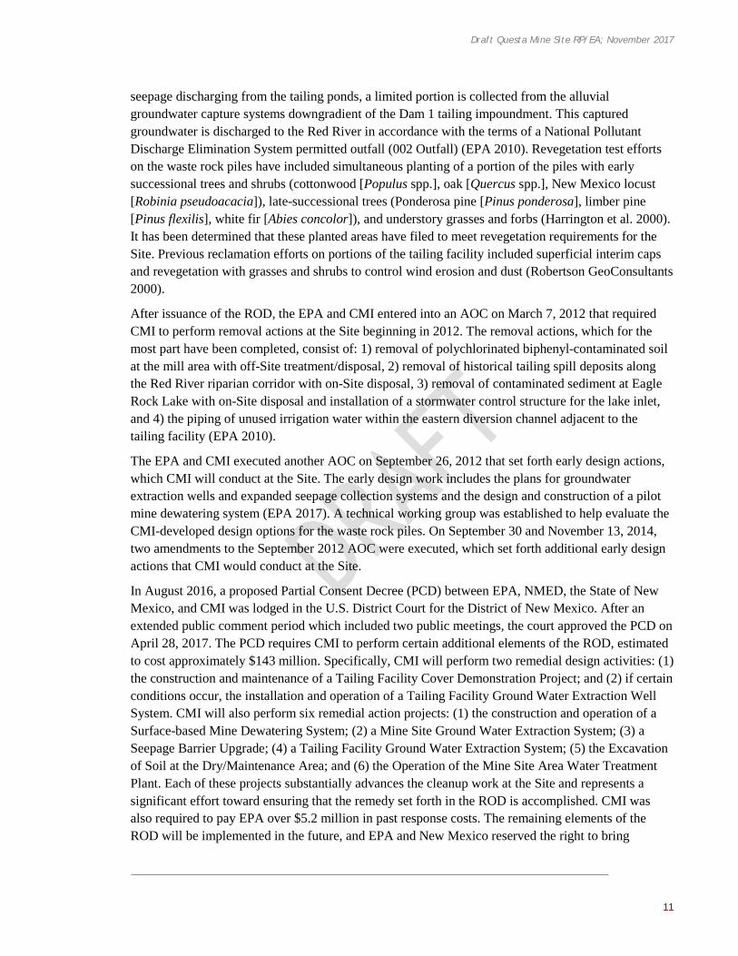
After issuance of the ROD, the EPA and CMI entered into an AOC on March 7, 2012 that required CMI to perform removal actions at the Site beginning in 2012. The removal actions, which for the most part have been completed, consist of: 1) removal of polychlorinated biphenyl-contaminated soil at the mill area with off-Site treatment/disposal, 2) removal of historical tailing spill deposits along the Red River riparian corridor with on-Site disposal, 3) removal of contaminated sediment at Eagle Rock Lake with on-Site disposal and installation of a stormwater control structure for the lake inlet, and 4) the piping of unused irrigation water within the eastern diversion channel adjacent to the tailing facility (EPA 2010).
The EPA and CMI executed another AOC on September 26, 2012 that set forth early design actions, which CMI will conduct at the Site. The early design work includes the plans for groundwater extraction wells and expanded seepage collection systems and the design and construction of a pilot mine dewatering system (EPA 2017). A technical working group was established to help evaluate the CMI-developed design options for the waste rock piles. On September 30 and November 13, 2014, two amendments to the September 2012 AOC were executed, which set forth additional early design actions that CMI would conduct at the Site.
In August 2016, a proposed Partial Consent Decree (PCD) between EPA, NMED, the State of New Mexico, and CMI was lodged in the U.S. District Court for the District of New Mexico. After an extended public comment period which included two public meetings, the court approved the PCD on April 28, 2017. The PCD requires CMI to perform certain additional elements of the ROD, estimated to cost approximately $143 million. Specifically, CMI will perform two remedial design activities: (1) the construction and maintenance of a Tailing Facility Cover Demonstration Project; and (2) if certain conditions occur, the installation and operation of a Tailing Facility Ground Water Extraction Well System. CMI will also perform six remedial action projects: (1) the construction and operation of a Surface-based Mine Dewatering System; (2) a Mine Site Ground Water Extraction System; (3) a Seepage Barrier Upgrade; (4) a Tailing Facility Ground Water Extraction System; (5) the Excavation of Soil at the Dry/Maintenance Area; and (6) the Operation of the Mine Site Area Water Treatment Plant. Each of these projects substantially advances the cleanup work at the Site and represents a significant effort toward ensuring that the remedy set forth in the ROD is accomplished. CMI was also required to pay EPA over $5.2 million in past response costs. The remaining elements of the ROD will be implemented in the future, and EPA and New Mexico reserved the right to bring

Draft Questa Mine Site RP/EA; November 2017
12
additional actions to ensure that they are. Periodic updates about work at this Site should be available through EPA’s Superfund website.4
2.3 RELATIONSHIP OF NRDA TO REMEDIAL ACTIV IT IES
In a process distinct from the NRDA activities undertaken by the Trustees, removal and remediation actions (or response actions) are overseen by EPA or State regulatory agencies with the objective of controlling exposure to released hazardous substances to protect human health and the environment (as described in Section 2.2). Remedial activities at the Site are ongoing, and the Trustees will ensure selected restoration does not conflict or interfere with any planned or proposed response actions.
The distinction between remedial activities and NRDA is important, particularly since both sets of activities often operate concurrently. Remedial actions, as defined in 42 U.S.C. § 9601(24), are:
Those actions consistent with permanent remedy taken instead of or in addition to removal actions in the event of a release or threatened release of a hazardous substance into the environment, to prevent or minimize the release of hazardous substances so that they do not migrate to cause substantial danger to present or future public health or welfare or the environment.
Remedial actions aim to remove or reduce the human health and ecological risks associated with hazardous substances at a site to acceptable levels. These efforts are typically funded by the potentially responsible parties (PRPs), the Superfund program, or a combination of both. Remedial activities can range from dredging and capping operations to removal and disposal of contaminated materials in landfills, for example. These efforts often re-expose site resources to the hazardous substances of concern for a short time period or may permanently alter habitat structure. It is an anticipated risk that is tempered by the knowledge that long-term benefits will be obtained through remediation of the hazardous substances.
NRDA, however, as defined in 43 C.F.R. §11.10:
… provides a procedure by which a natural resource trustee can determine compensation for injuries to natural resources that have not been nor are expected to be addressed by response actions …
NRDA takes into account the losses that the public has incurred due to the release of hazardous substances as well as additional injuries resulting from remedial activities addressing such releases. The assessment aims to compensate the public for these natural resource losses and lost human use of the site (e.g., foregone or diminished recreational fishing trips and tribal lost use). Damages calculated through the NRDA process allow trustees to restore injured natural resources and compensate for resource services that have been lost. To the extent possible, NRDA and remedial activities should be coordinated (43 C.F.R. §11.31(a)(3)).
4 EPA’s Superfund Website is: https://cumulis.epa.gov/supercpad/cursites/csitinfo.cfm?id=0600806

Draft Questa Mine Site RP/EA; November 2017
13
2.4 NATURAL RESOURCE DAMAGE ASSESSMENT AND RESTORATION
The objective of NRDA is to compensate the public for injuries to natural resources caused by releases of hazardous substances to the environment through restoration of injured natural resources and/or lost resource services. To determine whether restoration is necessary, the Trustees completed a number of interim steps outlined in the DOI NRDA regulations (43 C.F.R. Part 11), described below and illustrated in Figure 2-2.
Under Section 107(f)(1) of CERCLA, damages can only be used to restore, replace, or acquire the equivalent of trust resources injured, destroyed, or lost as a result of the release of hazardous substances. The amount or “scale” of restoration required to compensate for these losses depends on the nature, spatial extent and severity of resource injuries, the time period over which resources have been injured, and the time required for resources to return to baseline conditions.
As noted previously, this draft RP/EA has been developed to evaluate and, ultimately, select restoration projects designed to compensate the public for injuries that have occurred to natural resources. Implementation of selected restoration projects would occur over a period of time, depending on the project type.
FIGURE 2-2 PHASES OF THE NATURAL RESOURCE DAMAGE ASSESSMENT PROCESS
2.4.1 NATURAL RESOURCE DAMAGE ASSESSMENT AND RESTORATION ACTIVITIES AT THIS SITE
NRDA activities at the Site commenced with the finalization of a Preassessment Screen Determination report in November 2002. In the Preassessment Screen, the Trustees determined that hazardous substances were released and those releases likely adversely affected natural resources under their trusteeship. They also concluded that data sufficient to pursue an assessment were readily available or could be obtained at a reasonable cost, and that the response actions were unlikely to

Draft Questa Mine Site RP/EA; November 2017
14
sufficiently remedy the injury to natural resources without further action (Natural Resource Trustees 2002).
The Trustees proceeded with assessment activities to evaluate natural resource injuries and estimate the quantity and nature of those injuries and associated service losses resulting from the releases of hazardous substances from the Site. These assessment activities provided the Trustees with an understanding of injuries to natural resources and losses in ecological and groundwater services, as well as the type, scale, and scope of restoration activities necessary to address those injuries. The Trustees propose to resolve the natural resource damages liability, as described in Section 2.4.2, and they developed this draft RP/EA to explain how they plan to use monies collected as natural resource damages for the restoration of natural resources and services at the Site.
2.4.2 NATURAL RESOURCES DAMAGES SETTLEMENT
From 2001 through 2014, the Trustees and CMI engaged in intermittent negotiations regarding the claim for injury to natural resources resulting from releases of hazardous substances at the Site. During these negotiations and assessment activities, CMI paid the Trustees and their consultant approximately $3.4 million.
A variety of government agencies were involved in the negotiations and assessment work. Specifically, the discussions included:
• ONRT; • The New Mexico Attorney General’s Office; • FWS; • BLM; • The Department of the Interior Solicitor’s Office; • The Southwestern Region of the Forest Service; • The U.S. Department of Agriculture’s Office of the General Counsel; and, • The U.S. Department of Justice, Environment and Natural Resources Division,
Environmental Enforcement Section.
The EPA was also consulted during the settlement negotiations. The parties reached agreement on the terms to settle the natural resource damages claim in 2014, which was embodied in a Consent Decree. In order to formalize the settlement, the U.S. and the State of New Mexico (“State”) filed a Complaint in federal district court in New Mexico. The U.S. and the State filed the Complaint on August 28, 2014, and simultaneously filed and lodged the proposed Consent Decree. The matter was captioned as U.S. and New Mexico v. Chevron Mining, Inc., No. 1:14-cv-783, District of New Mexico. The U.S. and the State then issued a notice of the lodging of the proposed Consent Decree in the Federal Register at 79 Fed. Reg. 53081 (September 5, 2014).
The lodging of the Consent Decree initiated a period of public comment. The Trustees received 12 requests for extension or delay to the public comment period. In response, the Trustees extended the public comment period through November 26, 2014. The Trustees received nine letters or emails with substantive comments. The commenters asserted that the conditions at and near the mine showed that the Trustees’ assessment of the impact to natural resources was too narrow. The commenters also asserted that too much time has elapsed during the settlement negotiations, thus invalidating the cost estimates used to justify the adequacy of the settlement. The commenters also objected that the

Draft Questa Mine Site RP/EA; November 2017
15
Trustees did not employ all regulatory tools available to them in assessing injury and forming a plan for the restoration of resources.
The Trustees evaluated the public comments and prepared a document titled Technical Response to Public Comments. Many of the issues raised by the commenters had already been considered by the Trustees, who reached different conclusions based on their scientific and legal expertise. Perhaps most important, many of the comments did not account for the relationship of the NRDA claim to the remedial clean-up actions required for the mine (and occurring separately) under other legal authorities of EPA and other State agencies.5
After considering public comments, the Trustees concluded that a departure from the Consent Decree as originally proposed was not warranted. On September 3, 2015, the U.S. and the State filed a motion asking the court to sign and enter the Consent Decree. Copies of all of the public comments were included as an exhibit to the motion. A copy of the Technical Response to Public Comments was also included as an exhibit to the motion. The U.S. and the State notified all of the commenters that they had filed the motion.
The court approved and entered the Consent Decree on September 30, 2015. In general terms, the Decree requires CMI to:
1. Transfer of 91 hectares (225 acres) of land known as the Anderson Ranch, a property located approximately 19 kilometers (12 miles) northeast of the mine, to the BLM. The property includes about 40 hectares (100 acres) of wetlands that are relatively rare in the area (Figure ES-1);
2. Pay approximately $200,000 of Trustees’ past assessment costs, beyond the $3.4 million that CMI has already paid to the Trustees and their consultant for previous assessment costs; and
3. Pay approximately $4 million to fund the restoration, replacement, or acquisition of natural resources through projects. This includes approximately $1.5 million for aquatic habitat restoration projects and $2.5 million for groundwater restoration projects.
In exchange for the conveyance of land and payments, Chevron received a release from liability due to injuries to natural resources. The release is subject to standard re-openers.
Within the Consent Decree, Paragraphs 6, 15 and 16 are relevant to this RP/EA. Paragraph 6 of the Consent Decree directs Chevron to make payments that total $197,222.57 to named U.S. and State agencies. Beyond these payments, Paragraph 6(c) directs as follows:
The balance, after completing the payments required by subparagraphs (a) through (b) -- at least $4,000,000.00 -- shall be placed in an interest-bearing court registry account of the United States District Court for the District of New Mexico, in the manner specified by the
5 The ongoing and planned cleanup work overseen by EPA and other State agencies will cover many of the other impacts of concern to the commenters. In 2010, EPA, with the concurrence of the New Mexico Environment Department, selected a clean-up plan for the mine that EPA estimates will cost at least $500 million. The remedy selected by EPA is documented in a Record of Decision (“ROD”). The remedy will address the acid rock drainage from nine (9) enormous waste rock piles and the tailings seepage that contaminates ground water, surface water and sediment at the site. This clean-up will contain some of the contamination at its source. The clean-up will also remediate much of the existing contamination by, among other things, extracting and treating groundwater, removing soil contaminated with polychlorinated biphenyl (“PCB”) and molybdenum, and dredging and removing sediment contaminated with metals. See EPA 2010.

Draft Questa Mine Site RP/EA; November 2017
16
Clerk of the Court for use in compliance with the terms of this Decree, as follows: $2,500,000 (including any interest earned on that sum) designated for use by ONRT to plan and implement projects designed to restore, replace, and / or acquire the equivalent of the ground water resources injured, destroyed, or lost as a result of the release of hazardous substances at or from the Site, and the remainder (including any interest earned thereon) designated for use by the Trustees jointly to plan and implement projects designed to restore, replace, and/or acquire the equivalent of habitat resources injured, destroyed, or lost as a result of the release of hazardous substances at or from the Site.
Paragraph 15 states:
Management and Application of Funds. All funds disbursed from the court registry accounts pursuant to Subparagraphs 6.c and 6.d shall be used to pay for Future Costs and Trustee-sponsored natural resource restoration activities in accordance with this Consent Decree and applicable law. All such funds shall be applied toward the costs of restoration, rehabilitation, or replacement of injured Natural Resources, and/or acquisition of equivalent resources, including but not limited to any administrative costs and expenses for, and incidental to, restoration, rehabilitation, replacement, and/or acquisition of equivalent resources planning, and any restoration, rehabilitation, replacement, and/or acquisition of equivalent resources undertaken.
Paragraph 16 states:
Restoration Planning. The Trustees intend to prepare the separate restoration plan describing how the funds dedicated for trustee-sponsored natural resource restoration efforts under this Section will be used. In the course of that preparation, ONRT will prepare the portion of the restoration plan that relates to ground water resources. As provided by 43 C.F.R. Section 11.93, the plan will identify how funds will be used for restoration, rehabilitation, replacement, or acquisition of equivalent resources. The plan may also identify how funds will be used to address services lost to the public until restoration, rehabilitation, replacement, and/or acquisition of equivalent resources is completed. The Trustees intend to solicit public review and comment on the restoration plan and in no event will any project proceed without the public first receiving the opportunity to review the proposed project and submit comments on the proposal to the Trustees and Trustees’ considering the comments and finalizing the restoration plan. Funds disbursed pursuant to this paragraph to the ONRT then shall be deposited into the Natural Resource Trustee Fund and shall be used in a manner consistent with the New Mexico Natural Resources Trustee Act, NMSA 1978, Section 75-7-5 (2007), to restore, replace, or acquire equivalent natural resources in the area of the Site where natural resource injuries occurred.
Also of note is Paragraph 6(d) which states:
Upon request to the Court from the ONRT or the Trustees, as provided by Paragraph 6(c), that is accompanied by the restoration plan conforming to Section IX of this Decree and 43 C.F.R. Section 11.93 and bearing approval of the Trustees, the Clerk of the Court shall pay from the registry to the Trustees sums requested, in accordance with this Consent Decree and the restoration plan.
The Trustees have prepared this RP/EA consistent with the requirements in Paragraphs 6, 15 and 16 of the Consent Decree.

Draft Questa Mine Site RP/EA; November 2017
17
CHAPTER 3 | AFFECTED ENVIRONMENT
Hazardous substances released from the Site have affected surface water, groundwater, terrestrial habitat and resources, as well as riparian habitat, aquatic invertebrates, and fish populations. The Trustees’ proposed restoration actions, included in the Preferred Restoration Alternative, would help restore these natural resources but may also have environmental consequences. This section describes the physical, biological (including endangered and threatened species), socioeconomic, and cultural and historical resources that may be affected by implementing restoration projects in the area, as required by NEPA.
3.1 PHYSICAL ENVIRONMENT
The Red River watershed is located in northern New Mexico (Taos County) and includes the Carson National Forest, other public lands, and private land holdings, as well as the Site itself (see Figure 1-1). The Red River, the principal drainage of the basin, flows for 51 kilometers (32 miles) from its source in the Sangre de Cristo Mountains to its discharge point into the Rio Grande River (Melancon et al. 1982). The lower 6.4 kilometers (4 miles) of the Red River is part of the Cañon del Rio Grande Wild and Scenic River System (Garn 1986). Tributaries to the Red River in the lower watershed include Bitter Creek, Cabresto Creek, Columbine Creek, and several gulches and washes that intermittently discharge to the Red River (Figure 1-1). The Red River Watershed Restoration Action Strategy organized the watershed into eight reaches, each having their own distinct geography, jurisdictions, water quality issues, impairments, and potential restoration actions (Red River Watershed Group 2003). These subwatershed areas are (from upstream to downstream): 1) Upper Red River Valley, 2) Town of Red River, 3) Middle Red River Valley, 4) Cabresto Creek, 5) Village of Questa, 6) Cerro and Guadalupe Mountain, 7) La Lama, and 8) Lower Red River Gorge. Due to land uses in the watershed, a variety of water quality issues affect the Red River, including (listed approximately from upstream to downstream):
• Dense forests and excessive fuel loading in spruce-fir and mixed conifer areas from historical fire and forestry management practices;
• Acid rock drainage, metals, and sediment loading from natural hydrothermal scar areas; • Sediment and nutrient loading from livestock and wildlife grazing; • Nutrient loading from septic systems in the upper valley floodplain, open pits, holding tanks,
and increased population growth; • Impacts to wetlands, riparian, and stream habitat areas due to dense development in the upper
valley; • Sediment erosion from excessive All-Terrain Vehicle use; • Erosion from unnaturally dense woodlands (e.g., ponderosa pine and pinon-juniper) where
grasses and groundcover are crowded out; • Sediment erosion from road cuts and other paved roads (e.g., along State Highway 38); • Acidic groundwater seeps along the Red River; and,

Draft Questa Mine Site RP/EA; November 2017
18
• Habitat loss due to degraded and channelized streambed.
The geologic setting of this area is the San Luis Basin of the Rio Grande rift, along the eastern edge of the Taos Plateau volcanic field (Bauer et al. 2015). The Village of Questa sits between the crystalline rocks of the Sangre de Cristo Mountains to the east and the volcanic Guadalupe Mountain to the west. A fault along the eastern edge of Questa marks the transition from down-dropped rift basin to the uplifted mountains (Bauer et al. 2015). The village itself is built on basin-fill sediments that have eroded from the Sangre de Cristo Mountains. This basin fill is thickest along the eastern edge of Guadalupe Mountain, where these deposits reach depths of approximately 1,219 meters (4,000 feet) (Bauer et al. 2015). The Red River has cut deep canyons in the Sangre de Cristo Mountains and the Taos Plateau volcanic field as it has flowed west to the Rio Grande River. Similarly, the overall flow of shallow groundwater is westerly. The regional water table (within the Santa Fe Group) dramatically deepens as it reaches highly fractured rocks associated with Guadalupe Mountain to the west of Questa. The municipal water supply for the Village of Questa is extracted from the top of the Santa Fe Group.
3.2 BIOLOGICAL ENVIRONMENT
Like many mountainous areas of the southwestern U.S., the biological environment in the Red River watershed changes with elevation, from low elevation grasses and shrubs through mid-elevation woodlands and forest to high elevation conifer forests and alpine tundra. Along the Red River, riparian habitat can be variable in structure and may include riparian forest (both deciduous woodland and conifer forest); montane riparian shrub mixed with meadows; dry, mesic, and wet meadows along tributaries at upper elevations; and disturbed and sparsely vegetated areas (EPA 2010). Riparian vegetation in the watershed includes New Mexico alder (Alnus oblongifolia), cottonwood (Populus spp.), and willow (Salix spp.). In the spruce-fir life zone, tree species found in the vicinity of the Site include White fir, Engelmann spruce (Picea engelmannii), Colorado blue spruce (Picea pungens), and Douglas fir (Pseudotsuga menziesii). In the mixed conifer zone, tree species include Douglas fir, ponderosa pine, aspen (Populus tremuloides), and narrowleaf cottonwood (Populus angustifolia). Ponderosa pine and mountain mahogany (Cercocarpus breviflorus, a shrub) are common in the ponderosa pine zone. Pinyon pine (Pinus edulis), juniper (Juniperus spp.), and Gambel oak (Quercus gambelli) are typical species in pinyon-juniper woodlands. Sage (Artemisia spp.) and rubber rabbitbrush (Ericameria nausosa) are typical shrubs in the grassland/shrubland zone (URS Corporation 2005). The plant communities present in the Red River Watershed by elevation are summarized in Table 3-1, below.
Due to the variety of habitats, a diverse wildlife community is also found in the watershed. Common mammals at lower elevations (grassland/shrubland and pinyon pine/juniper communities) include mule deer (Odocoileus hemionus), elk (Cervus canadensis), coyote (Canis latrans), gray fox (Urocyon cinereoargenteus), red fox (Vulpes vulpes), ringtail (Bassariscus astutus), and cottontail (Sylvilagus spp.) with occasional sightings of black bear (Ursus americanus), mountain lion (Puma concolor), and bobcat (Lynx rufus) (Molycorp 2000, EPA 2010). Numerous small mammals can be found in the area, including the white-tailed jackrabbit (Lepus townsendii), Ord’s kangaroo rat (Dipodomys ordii), deer mouse (Peromyscus spp.), pocket gopher (Geomyidae), least chipmunk (Tamias minimus), and numerous bats (EPA 2010). American red squirrel (Tamiasciurus hudsonicus), wood rat (Neotomoa spp.), golden-mantled ground squirrel (Spermophilus lateralis),

Draft Questa Mine Site RP/EA; November 2017
19
porcupine (Erethizon dorsatum), and various species of mice and voles have also been reported (EPA 2010).
The western spadefoot toad (Spea hammondii), leopard frog (Lithobates pipens), collared lizard (Crotophytus collaris), northern fence lizard (Sceloporus undulates), Great Plains skink (Plestiodon obseletus), bullsnake (Pituophis catenifer), and prairie rattlesnake (Crotalus viridis) are examples of amphibians and reptiles found in the area (Molycorp 2000, EPA 2010). The most abundant fish resident species near the Site is non-native brown trout (Salmo trutta) and hatchery-raised rainbow trout (Oncorhynchus mykiss) (EPA 2010). Brook trout (Salvelinus fontinalis) have been found in Cabresto Creek and the upper reaches of Red River, and Rio Grande cutthroat trout have been identified upstream of the Town of Red River (EPA 2010). Some white suckers have also been found (Catostomus commersoni). Benthic macroinvertebrates include insect orders Ephemeroptera (mayflies), Plecoptera (stoneflies), Coleoptera (beetles), Trichoptera (caddisflies), and Diptera (flies, including mosquitoes) (EPA 2010). Periphyton is primarily represented by diatoms and blue green algae.
TABLE 3 -1 PLANT COMMUNITIES PRESENT IN THE RED RIVER WATERSHED, ACCORDING TO
ELEVATION
PLANT COMMUNITY ELEVATION CHARACTERISTIC PLANT SPECIES
Spruce-Fir 9,000-11,000 feet 2,743-3,353 meters
Engelmann Spruce, Colorado Blue Spruce, Douglas Fir, Subalpine Fir, White Fir
Subalpine Meadows > 9,000 feet >2,743 meters
Fescues, sedges, rushes, Arizona willow, marsh marigold, elephanthead, shrubby cinquefoil, and Engelmann spruce
Mixed Conifer Forest 8,000-9,000 feet 2,438-2,743 meters
Douglas Fir, Ponderosa Pine, Aspen, Narrowleaf Cottonwood
Ponderosa Pine 6,500-8,500 feet 1,981-2,591 meters
Ponderosa Pine, Mountain Mahogany
Pinyon-Juniper Woodlands
5,000-7,000 feet 1,524-2,134 meters
Pinyon Pine, Juniper, and Gambel Oak
Mixed Grassland/Shrubland
4,500-5,500 feet 1,372-1,676 meters
Sagebrush and Rubber Rabbitbrush
In a study conducted in the Guadalupe Mountains near Questa from 1984 to 1985, 133 bird species were recorded (Kennedy and Stahlecker 1986). Common species in the shrubland/grassland habitat included Brewer’s sparrow (Spizella breweri), vesper sparrow (Pooecetes gramineus), and sage sparrow (Artemisiospiza nevadensis). Common species in the pinyon-juniper habitat included black-throated gray warblers (Setophaga nigrescens), juniper titmice (Baeolophus ridgwayi), mountain chickadees (Poecile gambeli), and brown-headed cowbirds (Molothrus ater). Western tanager (Piranga ludoviciana) and dark-eyed junco (Junco hyemalis) have also been reported (EPA 2010). Recently spotted birds in proximity to Guadalupe Mountain include Cooper’s hawk (Accipiter cooperii), great horned owl (Bubo virginianus), hairy woodpecker (Picoides villosus), plumbeous vireo (Vireo plumbeus), Woodhouse’s scrub-jay (Aphelocoma woodhouseii), Clark’s nutcracker (Nucifraga columbiana), black-billed magpie (Pica hudsonia), common raven (Corvus corax), bushtit (Psaltriparus minimus), white-breasted nuthatch (Sitta carolinensis), blue-gray gnatchatcher (Polioptila caerulea), and yellow-rumped warbler (Setophaga coronata) (Herrera-Olivas [BLM], Email Communication, October 16, 2017).
Draft Questa Mine Site RP/EA; November 2017
20
3.2.1 ENDANGERED AND THREATENED SPECIES
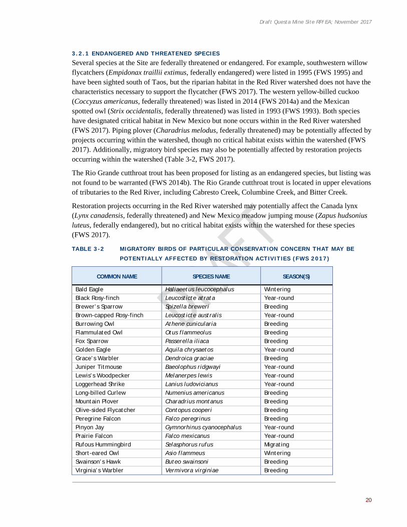
Several species at the Site are federally threatened or endangered. For example, southwestern willow flycatchers (Empidonax traillii extimus, federally endangered) were listed in 1995 (FWS 1995) and have been sighted south of Taos, but the riparian habitat in the Red River watershed does not have the characteristics necessary to support the flycatcher (FWS 2017). The western yellow-billed cuckoo (Coccyzus americanus, federally threatened) was listed in 2014 (FWS 2014a) and the Mexican spotted owl (Strix occidentalis, federally threatened) was listed in 1993 (FWS 1993). Both species have designated critical habitat in New Mexico but none occurs within in the Red River watershed (FWS 2017). Piping plover (Charadrius melodus, federally threatened) may be potentially affected by projects occurring within the watershed, though no critical habitat exists within the watershed (FWS 2017). Additionally, migratory bird species may also be potentially affected by restoration projects occurring within the watershed (Table 3-2, FWS 2017).
The Rio Grande cutthroat trout has been proposed for listing as an endangered species, but listing was not found to be warranted (FWS 2014b). The Rio Grande cutthroat trout is located in upper elevations of tributaries to the Red River, including Cabresto Creek, Columbine Creek, and Bitter Creek.
Restoration projects occurring in the Red River watershed may potentially affect the Canada lynx (Lynx canadensis, federally threatened) and New Mexico meadow jumping mouse (Zapus hudsonius luteus, federally endangered), but no critical habitat exists within the watershed for these species (FWS 2017).
TABLE 3 -2 MIGRATORY BIRDS OF PARTICULAR CONSERVATION CONCERN THAT MAY BE
POTENTIALLY AFFECTED BY RESTORATION ACTIVIT IES (FWS 2017)
COMMON NAME SPECIES NAME SEASON(S)
Bald Eagle Haliaeetus leucocephalus Wintering Black Rosy-finch Leucosticte atrata Year-round Brewer’s Sparrow Spizella breweri Breeding Brown-capped Rosy-finch Leucosticte australis Year-round Burrowing Owl Athene cunicularia Breeding Flammulated Owl Otus flammeolus Breeding Fox Sparrow Passerella iliaca Breeding Golden Eagle Aquila chrysaetos Year-round Grace’s Warbler Dendroica graciae Breeding Juniper Titmouse Baeolophus ridgwayi Year-round Lewis’s Woodpecker Melanerpes lewis Year-round Loggerhead Shrike Lanius ludovicianus Year-round Long-billed Curlew Numenius americanus Breeding Mountain Plover Charadrius montanus Breeding Olive-sided Flycatcher Contopus cooperi Breeding Peregrine Falcon Falco peregrinus Breeding Pinyon Jay Gymnorhinus cyanocephalus Year-round Prairie Falcon Falco mexicanus Year-round Rufous Hummingbird Selasphorus rufus Migrating Short-eared Owl Asio flammeus Wintering Swainson’s Hawk Buteo swainsoni Breeding Virginia’s Warbler Vermivora virginiae Breeding

Draft Questa Mine Site RP/EA; November 2017
21
COMMON NAME SPECIES NAME SEASON(S)
Western Grebe Aechmophorus occidentalis Breeding Williamson’s Sapsucker Sphyrapicus thyroideus Breeding Willow Flycatcher Empidonax traillii Breeding
3.3 LANDSCAPE SCALE ECOLOGICAL STRESSORS
Based on the unequivocal evidence of warming of the Earth’s climate from observations of increases in average global air and ocean temperatures, widespread melting of glaciers and polar ice caps, and rising sea levels recorded in the Intergovernmental Panel on Climate Change Report (Intergovernmental Panel on Climate Change (IPCC) 2013), climate change is now a factor in all Federal agency decision-making (United States Government Accountability Office 2007). The FWS has incorporated climate change into its decision making (FWS 2010). The Earth’s surface warmed by an average of 0.74 degrees Celsius (1.3 degrees Fahrenheit) during the 20th century and the IPCC (2013) projects that there will be an increase in the frequency of extreme weather events that are temporally and spatially more variable as a result of climate change.
Global climate information has been downscaled to our region of interest, and projected into the future under two different scenarios of possible emissions of greenhouse gases using a mean of models (Alder and Hostetler 2017). The range of values encompasses the Representative Concentration Pathways 4.5 and 8.5 greenhouse gases scenarios. In the Upper Rio Grande watershed including the Red River, a 10.8 to 12.8 percent increase in maximum temperature in the intermediate term (next 25 years) and 12.8 to 23.6 percent increase longer term (next 50 years) (up to1.9 degrees Celsius, 3.4 degrees Fahrenheit) is predicted (U.S. Geological Survey 2017). Summer precipitation is predicted to decrease 1.5 to 2.2 percent in the intermediate term and 0.4 to 3.3 percent in the longer term. Both snow pack and soil water storage show more substantial decreases in both the intermediate (15.8 to 30.7 percent and 4.1 to 9.0 percent) and longer term (40.2 to 56.2 percent and 14.4 to 21.9 percent). In summary, the mean model predicts an increase in maximum temperature, a modest decline in summer precipitation, and more substantial declines in snow pack and soil water storage.
3.4 SOCIOECONOMIC RESOURCES
Questa is a small rural town with a population of 1,770 people, as reported in the 2010 Census (United Census Bureau 2010). The basin in the vicinity of Questa supports traditional family agriculture. The nearby Town of Red River had a year-round population of 477 people, according to the 2010 Census. Red River primarily has a tourist economy, focused on the Red River ski area in the winter. However, the Red River valley supports in-state and out-of-state tourism year-round. Summer tourism is focused on the Carson National Forest campgrounds and fishing opportunities in the Red River, associated lakes, and tributaries. Winter tourism is focused on skiing and snowmobile recreation.
3.4.1 ENVIRONMENTAL JUSTICE
Executive Order 12898 directs Federal agencies to “make achieving environmental justice part of its mission by identifying and addressing, as appropriate, disproportionately high and adverse human health or environmental effects of its programs, policies, and activities on minority populations and low-income populations” (Council on Environmental Quality (CEQ) 1997).

Draft Questa Mine Site RP/EA; November 2017
22
According to data from the United States Census Bureau, 1,770 people live in the Village of Questa from a variety of backgrounds (Table 3-3) (United States Census Bureau 2010). Though the median household income in this area is $26,761, approximately 30 percent of individuals live below poverty level.
TABLE 3 -3 CENSUS DATA FOR RACE IN THE VILLAGE OF QUESTA
RACE INDIVIDUALS PERCENT
American Indian and Alaska Native 20 1.1 Asian 6 0.3 Black or African American 6 0.3 Native Hawaiian and Other Pacific Islander 0 0 Other 445 25.1 Two or More Races 65 3.7 White 1,228 69.4 Total Population 1,770 100
3.5 CULTURAL AND HISTORIC RESOURCES
Though the area in and around Taos County has been used by humans as a hunting ground for almost as long as they have occupied North America, the earliest archaeological evidence of humans in the locality of Questa is of the Upper Rio Grande Culture (also known as the Oshara Culture) from approximately 5,000 years ago (Ortega and Cuddihy 2003). A variety of Native American groups have used this area over time, including Ancestral Pueblos, Jicarilla, Ute, Comanches, and perhaps other Plains Indians tribes (Ortega and Cuddihy 2003). Spanish explorers and missionaries also visited the area for colonization and to search for gold. Upon discovering the workings of Native American mines, a slave trade developed to work these mines. Later, French trappers and the first United States military explorations discovered the region. Questa was officially founded in 1842 while the town of Red River began in earnest in the 1870s. These communities largely relied on mining, grazing, and trading for their livelihoods. At the close of the 19th century, the conflicts with Native Americans ended and the molybdenum mine opened. The Works Progress Administration helped the local population weather the Great Depression. During this time, the Fish Hatchery and Questa Elementary School were built (Ortega and Cuddihy 2003). Currently, both Questa and Red River are cultivating economies based on tourism, clean energy, and other areas (Red River 2017; Village of Questa 2017a).
As a result of the long and varied human history in this area, a number of cultural and historic resources exist. Most notably in Questa is the Historic San Antonio Church which was built in the mid-1800’s by the first families occupying the fledgling settlement (Village of Questa 2017b). Several sites in the Town of Red River are listed on the National Register of Historic Places (Table 3-4). Furthermore, Questa is located close to the ancient Kiowa trail, which was a Native American trade route. Evidence of human use can be seen in trail remnants, artifacts, and petroglyphs along the Sangre de Cristo Mountains (Ortega and Cuddihy 2003).

Draft Questa Mine Site RP/EA; November 2017
23
TABLE 3 -4 LISTED PROPERTIES IN RED RIVER ON THE NATIONAL REGISTER OF HISTORIC
PLACES (AS OF JULY 2015)
NAME REFERENCE NUMBER
Mallette, Orin, Cabin 84003055 Mallette, Sylvester M., Cabin 84003056 Pierce-Fuller House 84003058 Red River Schoolhouse 84003059 Young, Brigham J., House 84003063 Melson-Oldham Cabin 84003057 Black Copper Mine and Stamp Mill 00000875
3.6 SUMMARY
The Red River watershed encompasses a suite of habitat types that together support a wide range of plant, fish, and wildlife species. Current land use and socio-economic conditions, combined with environmental degradation, have adversely affected these natural resources. In addition to ecological functions, these natural resources also provide recreational, commercial, and cultural services. The Trustees will take these current resource conditions into account when evaluating and planning restoration.

Draft Questa Mine Site RP/EA; October, 2017
24
CHAPTER 4 | NATURAL RESOURCE INJURIES AND SERVICE LOSSES
Regulations promulgated by the DOI set out guidelines for determining when injuries to natural resources have occurred as a result of releases of hazardous substances (43 C.F.R. Part 11). Natural resources are defined in these regulations as “land, fish, wildlife, biota, air, water, groundwater, drinking water supplies, and other such resources” (43 C.F.R. § 11.14 (z)), and are divided into categories of surface water resources, groundwater resources, air resources, geologic resources (soil), and biological resources. As defined in these regulations, injury is a measureable adverse biological, chemical, or physical effect on natural resources, such as death, decreased population, or lost services (e.g., hunting opportunities, ecosystem functions). Based on the review of available information, the Trustees found reason to assess injuries to surface water, biological, and groundwater resources.
4.1 APPROACH TO INJURY QUANTIFICATION AND RESTORATION SCALING
From 2001 through 2014, the Trustees coordinated with CMI to identify and evaluate natural resource injuries as part of the assessment process. The Trustees used an injury assessment approach consistent with Type B assessment methodologies as described in 43 C.F.R. § 11.60 et seq. The Trustees were mindful that the regulations promote the use of cost effective procedures (43 C.F.R. § 11.11) and therefore relied on readily available information on the Site and releases of hazardous substances. Specifically, the Trustees used existing information to determine which natural resources had been potentially injured. The Trustees evaluated natural resource injuries resulting from releases of hazardous substances from the Site and compared the injured resources to the expected condition of the resource in the absence of the releases of hazardous substances (i.e., “baseline condition”) to estimate natural resource injuries.
To quantify the natural resource injuries, and to scale restoration (i.e., determine the amount of restoration required to compensate for the quantified natural resource injuries), the Trustees used both habitat equivalency analysis (HEA) and resource equivalency analysis (REA) approaches. HEA and REA are methods used to estimate the adverse impacts to a natural resource and the beneficial effects provided by restoration actions.6 A key element in conducting a HEA is defining the level of services provided by a habitat relative to baseline conditions; and for REA, defining the amount of a resource relative to baseline (e.g., amount of biomass). The concept of services, used in a HEA, incorporates the fact that over any time period a habitat would provide and support a range of ecological and human use functions (e.g., riparian habitat provides forage, spawning, and nursery habitat while supporting human use activities such as fishing or hunting). HEA assumes that this cumulative mix of functions can be quantified at discrete points in time (e.g., annually) relative to a baseline condition.
6 For details on the technical approach to completing an equivalency analysis, see Unsworth and Bishop 1994 or National Oceanic and Atmospheric Administration 2000.

Draft Questa Mine Site RP/EA; October, 2017
25
The HEA and REA methodology equates injured and restored areas or resources in units that integrate space and time. An injury of one “acre-year” or “bird-year”, for example, would account for one acre of land or one bird being injured for one year. Different levels of services also can be factored into HEA calculations. An injury of one “service-acre-year” would account for one acre of land being completely injured (i.e., 100 percent loss of habitat services) for one year. Finally, a discount rate is incorporated into the calculations, so that impacts and benefits occurring in different years are weighted differently. An annual discount rate of 3 percent is typically used in HEA calculations (National Oceanic and Atmospheric Administration 1999).
4.2 NATURAL RESOURCE INJURIES
This section provides a brief overview of the injury assessment for surface water, biological, and groundwater resources. More detailed information on the injury assessment is available in the Administrative Record.
4.2.1 IDENTIFICATION OF POTENTIALLY INJURED RESOURCES
Based on reviews of available information, the Trustees identified three categories of potentially injured resources: surface water, biological, and groundwater resources. Surface water and aquatic biota were identified as injured based on reviews of water quality data and biological data that indicated that fish and invertebrate populations are in worse condition downstream of the Site, compared to baseline conditions. Terrestrial resources, including soil, vegetation, and wildlife, were identified as potentially injured based on reviews of soil data that indicated the concentrations of hazardous substances in the soil exceed toxicity thresholds for relevant terrestrial wildlife. Finally, groundwater resources were identified as injured based on reviews of groundwater data that indicated concentrations of hazardous substances exceed New Mexico water quality standards.
4.2.2 INJURY QUANTIFICATION
As noted above, the Trustees used equivalency analysis approaches to quantify injuries and scale restoration actions. When quantifying natural resource injuries, the Trustees accounted for the “baseline conditions” of the resources, where baseline is defined as “the condition or conditions that would have existed at the assessment area had the…release of the hazardous substance under investigation not occurred” (43 C.F.R. § 11.14 (e)). In the Red River watershed, metals, sediment, and acid are naturally deposited in the river during heavy rainfall events from naturally formed alteration “scar” areas. These scar areas are characterized by steep topography, high rates of erosion, little to no vegetation, and include rocks with naturally high concentrations of metals (“mineralized rocks”) (Verplanck et al. 2006). The Trustees assumed that in the absence of releases from the Site, biological resources in the Red River would be degraded downstream of Hanson Creek as a result of the influence of the natural scar areas. Recovery of the river was assumed to start at Columbine Creek where clean water enters the Red River. Downstream of Columbine Creek, injuries to aquatic resources resulting from the Site were evaluated as the difference between observed conditions and the estimated degree of impact in the absence of releases from the mine. In summary, the Trustees accounted for the contribution of metals, sediments, and acid from the natural scars as part of the baseline condition of the watershed.
The Trustees’ approach to injury quantification for aquatic resources (surface water and aquatic biota), terrestrial resources (soil and terrestrial biota), and groundwater resources is described below.

Draft Questa Mine Site RP/EA; October, 2017
26
4.2.2.1 Aquat ic Resources
The Trustees’ injury evaluation for aquatic resources focused on the Red River adjacent to and downstream of the mine. The Trustees used a REA approach to quantify injury and restoration in changes to fish biomass over time (“pound-years”) to better equate losses and credits across streams and rivers of varying sizes that support different densities (and biomass) of fish. For example, for injured aquatic resources in the Red River, an injury of one “pound-year” would account for fish biomass in the river being reduced by one pound for one year. This allowed the Trustees to compare the benefits of restoration projects in small tributaries to the injuries occurring in the much larger Red River, which has a much greater potential biomass of resident fish.
4.2.2.2 Terrest r ia l Resources
For terrestrial resources, the Trustees’ used a HEA to estimate injuries and restoration benefits in units of “acre-years,” which equates projects in terms of the acreage of habitat injured or benefited, the duration of injury or benefit, and the level of services provided by the injured or benefited areas. The injury evaluation for terrestrial resources focused on areas with contaminated soils that could harm wildlife. The area of contaminated soil was used as the basis for quantifying the terrestrial injury.
4.2.2.3 Groundwater Resources
The injury evaluation for groundwater focused on groundwater at the mine and tailing impoundment areas that was contaminated as a result of the release of hazardous substances. A REA was undertaken to measure injury as the volume of groundwater at both the mine area and tailing area contaminated with sulfate above 600 milligrams/liter, which is the maximum sulfate concentration allowed for domestic water supply in New Mexico (New Mexico Administrative Code [NMAC] 20.6.2.3103). This estimate was used to develop a measure of injured groundwater quantified in acre-feet years. An acre-foot year is 1 acre-foot of water injured for 1 year. Both injury and restoration were quantified in acre-feet years.

Draft Questa Mine Site RP/EA; October, 2017
27
CHAPTER 5 | RESTORATION PROJECT IDENTIFICATION, SCREENING, AND EVALUATION PROCESS
As stated in Chapter 1, to meet the purpose of restoring injuries to natural resources and associated service losses caused by releases of hazardous substances at the Site, the Trustees have identified a need to implement restoration alternatives described in this draft RP/EA. This draft RP/EA describes the process the Trustees’ used to identify, screen, and evaluate potential restoration actions as well as the restoration actions the Trustees identified to compensate the public for natural resource injuries and service losses (i.e., how the Trustees for the Questa Mine Site NRDA will use natural resource damages to restore natural resources and compensate the public). Consistent with CERCLA and NEPA regulations, this draft RP/EA considers a reasonable number of alternative restoration actions and identifies a Preferred Restoration Alternative, informing the public as to the types and scale of restoration projects that are expected to compensate for injuries to natural resources.
In this chapter, the Trustees describe the process of developing this draft RP/EA. The process included identifying screening and evaluation criteria, soliciting potential restoration alternatives, and proposing restoration alternatives that are likely to restore the natural resources and natural resource services that have been injured as a result of hazardous substance releases from the Site. These actions are intended to make the public whole by providing compensation for lost natural resources and associated ecological services.
5.1 RESTORATION OBJECTIVES
As summarized in Chapter 4, the Trustees determined that injuries have occurred to natural resources in and around the Site, which provide ecological, cultural, and/or recreational services. The Trustees’ overall restoration objective is to compensate the public for these injuries through the implementation of restoration projects that provide comparable services in or near the Site. In order to meet this objective, the Trustees must identify, screen, and evaluate restoration projects (or alternatives under NEPA).
Restoration of injured resources and associated lost ecological services requires an approach that addresses injuries to aquatic resources, terrestrial resources, and groundwater. The Trustees developed this draft RP/EA based on the concept of selecting a “suite” of restoration actions that together would compensate for all injuries.
5.2 SOLICITING AND FORMULATING A WIDE RANGE OF RESTORATION PROJECTS
Restoration projects were solicited from the public and from the following agencies and organizations:
• Amigos Bravos • Molycorp, Inc. • New Mexico Association of Conservation Districts

Draft Questa Mine Site RP/EA; October, 2017
28
• New Mexico Department of Game and Fish • New Mexico Environment Department - Surface Water Quality Bureau, Groundwater Quality
Bureau, Construction Program Bureau, Drinking Water Bureau, and Petroleum Storage Bureau
• New Mexico Environment, Minerals, and Natural Resources Division - Abandoned Mine Lands Bureau
• New Mexico Finance Authority • Red River Watershed Group. • Trout Unlimited • U.S. Bureau of Land Management • U.S. Environmental Protection Agency Region 6 • U.S. Forest Service Questa Ranger District • Village of Questa
Through this process, the Trustees identified a number of restoration projects to potentially restore aquatic, terrestrial, and groundwater resources. These restoration projects include actions within and outside the Red River watershed.
5.3 SCREENING AND EVALUATION
5.3.1 SCREENING CRITERIA
After a range of restoration projects was solicited, an initial round of screening identified those projects that were carried through for further evaluation. DOI’s NRDA regulations (43 C.F.R. § 11.82(d)) provide natural resource trustees with specific factors to consider when selecting a Preferred Restoration Alternative, including, but not limited to, technical feasibility, cost effectiveness, and probability of project success. In addition, the Trustees can develop site-specific factors to evaluate and prioritize restoration projects. The Trustees used the following screening criteria to determine whether proposed projects met minimum standards of acceptability. To be acceptable, each project must (Table 5-1):
• Be consistent with relevant Federal, state, and local laws and policy; • Protect public health and safety, and the environment; • Be technically and administratively feasible; and, • Have a nexus to injured resources or lost services.
One restoration project was eliminated from further evaluation because it did not meet the screening criteria (see Section 5.4).
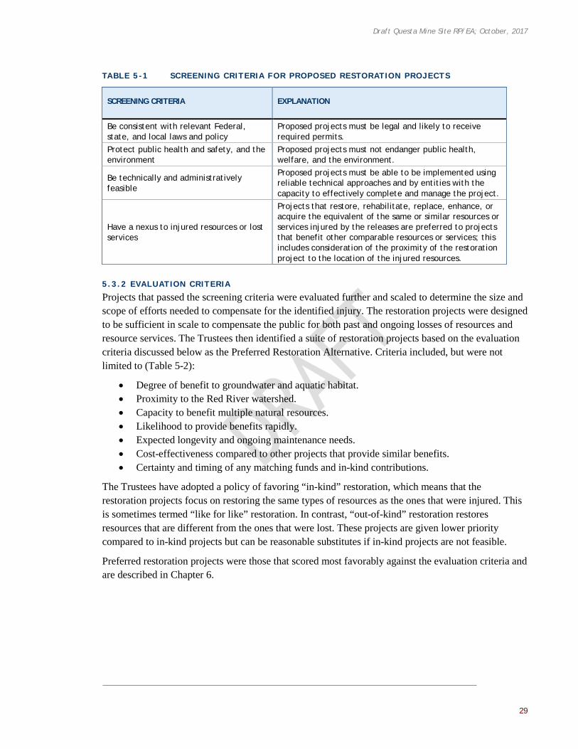
Draft Questa Mine Site RP/EA; October, 2017
29
TABLE 5 -1 SCREENING CRITERIA FOR PROPOSED RESTORATION PROJECTS
SCREENING CRITERIA EXPLANATION
Be consistent with relevant Federal, state, and local laws and policy
Proposed projects must be legal and likely to receive required permits.
Protect public health and safety, and the environment
Proposed projects must not endanger public health, welfare, and the environment.
Be technically and administratively feasible
Proposed projects must be able to be implemented using reliable technical approaches and by entities with the capacity to effectively complete and manage the project.
Have a nexus to injured resources or lost services
Projects that restore, rehabilitate, replace, enhance, or acquire the equivalent of the same or similar resources or services injured by the releases are preferred to projects that benefit other comparable resources or services; this includes consideration of the proximity of the restoration project to the location of the injured resources.
5.3.2 EVALUATION CRITERIA
Projects that passed the screening criteria were evaluated further and scaled to determine the size and scope of efforts needed to compensate for the identified injury. The restoration projects were designed to be sufficient in scale to compensate the public for both past and ongoing losses of resources and resource services. The Trustees then identified a suite of restoration projects based on the evaluation criteria discussed below as the Preferred Restoration Alternative. Criteria included, but were not limited to (Table 5-2):
• Degree of benefit to groundwater and aquatic habitat. • Proximity to the Red River watershed. • Capacity to benefit multiple natural resources. • Likelihood to provide benefits rapidly. • Expected longevity and ongoing maintenance needs. • Cost-effectiveness compared to other projects that provide similar benefits. • Certainty and timing of any matching funds and in-kind contributions.
The Trustees have adopted a policy of favoring “in-kind” restoration, which means that the restoration projects focus on restoring the same types of resources as the ones that were injured. This is sometimes termed “like for like” restoration. In contrast, “out-of-kind” restoration restores resources that are different from the ones that were lost. These projects are given lower priority compared to in-kind projects but can be reasonable substitutes if in-kind projects are not feasible.
Preferred restoration projects were those that scored most favorably against the evaluation criteria and are described in Chapter 6.
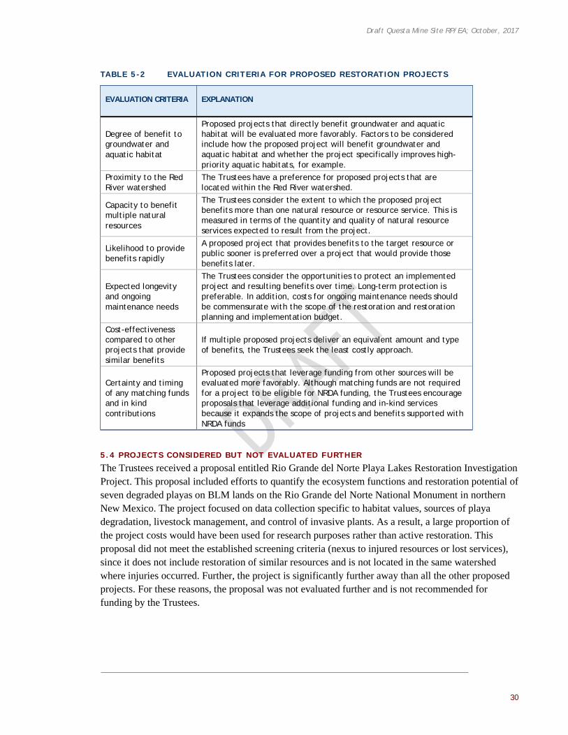
Draft Questa Mine Site RP/EA; October, 2017
30
TABLE 5 -2 EVALUATION CRITERIA FOR PROPOSED RESTORATION PROJECTS
EVALUATION CRITERIA EXPLANATION
Degree of benefit to groundwater and aquatic habitat
Proposed projects that directly benefit groundwater and aquatic habitat will be evaluated more favorably. Factors to be considered include how the proposed project will benefit groundwater and aquatic habitat and whether the project specifically improves high-priority aquatic habitats, for example.
Proximity to the Red River watershed
The Trustees have a preference for proposed projects that are located within the Red River watershed.
Capacity to benefit multiple natural resources
The Trustees consider the extent to which the proposed project benefits more than one natural resource or resource service. This is measured in terms of the quantity and quality of natural resource services expected to result from the project.
Likelihood to provide benefits rapidly
A proposed project that provides benefits to the target resource or public sooner is preferred over a project that would provide those benefits later.
Expected longevity and ongoing maintenance needs
The Trustees consider the opportunities to protect an implemented project and resulting benefits over time. Long-term protection is preferable. In addition, costs for ongoing maintenance needs should be commensurate with the scope of the restoration and restoration planning and implementation budget.
Cost-effectiveness compared to other projects that provide similar benefits
If multiple proposed projects deliver an equivalent amount and type of benefits, the Trustees seek the least costly approach.
Certainty and timing of any matching funds and in kind contributions
Proposed projects that leverage funding from other sources will be evaluated more favorably. Although matching funds are not required for a project to be eligible for NRDA funding, the Trustees encourage proposals that leverage additional funding and in-kind services because it expands the scope of projects and benefits supported with NRDA funds
5.4 PROJECTS CONSIDERED BUT NOT EVALUATED FURTHER
The Trustees received a proposal entitled Rio Grande del Norte Playa Lakes Restoration Investigation Project. This proposal included efforts to quantify the ecosystem functions and restoration potential of seven degraded playas on BLM lands on the Rio Grande del Norte National Monument in northern New Mexico. The project focused on data collection specific to habitat values, sources of playa degradation, livestock management, and control of invasive plants. As a result, a large proportion of the project costs would have been used for research purposes rather than active restoration. This proposal did not meet the established screening criteria (nexus to injured resources or lost services), since it does not include restoration of similar resources and is not located in the same watershed where injuries occurred. Further, the project is significantly further away than all the other proposed projects. For these reasons, the proposal was not evaluated further and is not recommended for funding by the Trustees.

Draft Questa Mine Site RP/EA; October, 2017
31
CHAPTER 6 | TRUSTEES’ PREFERRED RESTORATION ALTERNATIVE AND EVALUATION OF THE PROJECTS
Following the Trustees’ process for soliciting and screening potential restoration alternatives, the projects that met the screening criteria were assessed further using the evaluation criteria identified in Chapter 5. This chapter describes the Trustees’ evaluation of each of the proposed restoration projects and describes the Preferred Restoration Alternative. The Preferred Restoration Alternative includes the proposed restoration projects that met the screening criteria. However, given funding limitations, the Trustees are prepared to fund only certain aspects of the projects as described in Section 7.5. The analysis of environmental consequences for the proposed projects that are subject to NEPA analysis is also provided in Chapter 7.
6.1 SUMMARY OF PROPOSED PROJECTS AND THE PREFERRED RESTORATION ALTERNATIVE
The Trustees’ Preferred Restoration Alternative consists of a suite of restoration projects that would enhance or protect riparian and wetland habitats and improve groundwater resources. Several proposed projects involve active restoration of wetland and riparian habitat areas as well as enhancement of watershed health. The remaining projects would help restore groundwater resources in the area. The proposed projects and a summary of the Trustees’ screening and evaluation of those projects is provided in Table 6-1 below. Their locations are presented in Figure 6-1. Projects evaluated and recommended for funding are presented in two tiers. Tier 1 includes those projects the Trustees prioritized for funding. Tier 2 includes the South Ditch Diversion Structure, which met the restoration screening criteria and was evaluated further by the Trustees but is not being recommended for funding at this time (due to funding limitations).
The Trustees expect to use a variety of mechanisms for project implementation and will select the most appropriate mechanism for each project. The details and agreements will be determined between the Trustees and individual project proponents. The following mechanisms may be used for project implementation:
• Cooperative or grant agreement executed between a Federal agency or the Trustees and the designated implementing partner. Projects proposed for this funding mechanism are those that can be successfully completed only by the entity already associated with the project.
• Request for Proposals (RFP) issued by a state agency. An RFP is a competitive process that is open to all qualified bidders. The Trustees will establish the selection criteria for evaluating all proposals that are submitted in response to the RFPs. The selection of a contractor would result in a professional services contract.
• Interagency service agreement or memorandum of agreement executed by a state agency with another state agency or municipality, or inter- or intra-agency agreement between Federal agencies.

Draft Questa Mine Site RP/EA; October, 2017
32
TABLE 6 -1 RESULTS OF THE TRUSTEES’ RESTORATION PROJECT SCREENING AND
EVALUATION
PROJECT NAME* SCREENING SUMMARY
EVALUATION RANKING SUMMARY
RELATIVE PROJECT COST**
PREFERRED RESTORATION ALTERNATIVE (PROJECTS RECOMMENDED FOR FUNDING)
Tier 1 Preferred Restoration Projects
Aquatic Habitat Restoration in the Red River on FS Lands Passed High $
Municipal Sanitary Sewer System Improvements for the Village of Questa Passed High $$$
New Municipal Water Supply Well for the Village of Questa Passed Moderately High $$
Red River Aquatic Habitat Restoration within the Village of Questa (Poor and Fair Sections) Passed Moderately High $$$
Restoration of the Midnight Meadows Wetland Passed Moderate $$
Tier 2 Preferred Restoration Projects
South Ditch Diversion Structure Passed Low $
PROJECTS CONSIDERED BUT NOT RECOMMENDED FOR FUNDING
Rio Grande del Norte Playa Lakes Restoration Investigation Did not pass Not Applicable $
*Projects are listed alphabetically by funding category. **Projects associated with the $ symbol are low-cost projects below $200,000; projects associated with the $$ symbol are medium-cost projects between $200,000 and $1,000,000; and projects associated with the $$$ symbol are high-cost projects over $1,000,000.

Draft Questa Mine Site RP/EA; October, 2017
33
FIGURE 6-1 LOCATIONS OF PROJECTS INCLUDED IN THE PREFERRED RESTORATION
ALTERNATIVE

Draft Questa Mine Site RP/EA; October, 2017
34
6.2 TRUSTEE EVALUATION OF TIER 1 RESTORATION PROJECTS
6.2.1 AQUATIC HABITAT RESTORATION IN THE RED RIVER ON FS LANDS
6.2.1.1 Project Desc r ipt ion
This project, Aquatic Habitat Restoration in the Red River on FS Lands, was proposed by the Enchanted Circle Chapter of the non-profit organization, Trout Unlimited. The proposed habitat restoration project would occur on FS lands within the Village of Questa, located in Taos County, New Mexico. The project would be located approximately 305 meters (1,000 feet) upstream of the FS Questa Ranger District Headquarters.
This portion of the Red River is the first wide river section of low slope after an extended reach of confined canyon. Within the canyon area, New Mexico State Highway 38 constrains the floodplain and a number of ephemeral tributaries deliver large quantities of sediment from the naturally erosive mountainsides directly adjacent to the Red River. These factors, along with watershed-scale issues (e.g., urban development, mining, over-grown forestlands, and altered fire regimes) have degraded the reach of the Red River proposed for restoration.
The primary purpose of the restoration project is to provide trout with habitat areas that are suitable for feeding and resting by redefining the river channel. A variety of techniques would be used to accomplish this, such as filling and revegetating a bank area, excavating the channel bed in several locations, removing vegetation, installing rock features, and constructing log jams. Willow and cottonwood pole plantings would help accelerate the process of natural plant colonization in the floodplain. Shading the stream surface helps to moderate stream temperatures and leaf material provides a food source for insects, which would in turn be a food source for fish, birds, and other wildlife. Improving sediment transport within the stream channel would also promote the colonization of the area by aquatic insects and plants, which comprise the foundation of the aquatic food web and would attract trout to this reach. This work would be conducted along approximately 152 meters (500 feet) of stream length and adjacent floodplain.
6.2.1.2 Restorat ion Goal s
The overall restoration goal of this project is to restore aquatic habitat for the benefit of riparian natural resources and resource services by improving the impaired river morphology in this reach to a more natural state.
In order for trout to thrive, aquatic habitat must provide a number of benefits, including cold and oxygenated water, food in the form of insects, relief from currents, security from predators, gravel for spawning, and/or adequate access to these features in the form of unrestricted migration routes. The specific goals for improving trout habitat through this restoration project are listed below.
Aquatic Habitat Restoration in the Red River on FS lands – View of proposed
restoration project location.

Draft Questa Mine Site RP/EA; October, 2017
35
• Restore single thread channel configuration. • Increase sediment transport competency. • Stabilize eroding banks. • Establish and maintain grade control for deeper channel. • Increase pool habitat. • Improve aquatic habitat diversity. • Increase riparian vegetation on floodplains.
Concentrating the river’s flow into a single, non-braiding channel would allow for the transportation of its natural sediment bedload while encouraging the deposition of some fine sediment on a restored and well vegetated floodplain, rather than the channel bed. Furthermore, the development of pools provides trout a refuge from a host of environmental threats; including predators, warm temperatures, prolonged high flow events, and others. They also support healthy populations of aquatic insects, which in turn support the entire riparian food chain.
6.2.1.3 Probabi l i ty of Meet ing Restorat ion Goal s
The technologies proposed under this restoration project have been widely implemented in riparian habitat restoration projects nationwide, so it is highly likely that the structures could be installed as designed without issue. Trout Unlimited is also a well-regarded non-profit organization that has a successful history of implementing restoration projects within the Red River watershed (e.g., Red River Angling Park and Hatchery Barrier Project, see Section 2.1), which further supports the likelihood of project success. However, long-term sediment management is a concern in this reach, since it is described as a point of aggradation in the Red River drainage. Though channel restructuring may naturally help convey sediment through this reach, this aspect of the project must be monitored and adaptively managed to ensure long-term benefits from implementation of this restoration project.
6.2.1.4 Trustee Evaluat ion
This project ranked highly when assessed against the evaluation criteria. Specifically, this project is located within the Red River watershed and is expected to address aquatic resource injuries by providing a high level of benefit directly to aquatic resources. The degree of benefit to groundwater is low since the restoration project is focused on aquatic resources and not intended to benefit groundwater. However, there is potential for added groundwater and aquatic benefits if this project is implemented in combination with the Red River Aquatic Habitat Restoration within the Village of Questa project, which is located a short distance downstream (see Section 6.2.4). This project also has a high potential to benefit multiple natural resources since some riparian vegetation planting is proposed. It is anticipated that this project would provide benefits rapidly after construction.
The evaluation of the project’s expected longevity and maintenance needs ranked moderately. The Trustees are concerned that this is an existing depositional area that may continue to accrue sediment even after implementation if the upstream erosive areas are not addressed, which may lead to more project maintenance than anticipated. However, the Trustees are committed to monitoring the project to ensure success.
The project is moderately cost effective, as it is somewhat more expensive compared to similar NRDA projects in the area. The Enchanted Circle Chapter of Trout Unlimited and its New Mexico Trout Unlimited chapter partners’ willingness to provide matching funds and in-kind contributions

Draft Questa Mine Site RP/EA; October, 2017
36
(e.g., education on stream bank function, stream bank revegetation efforts, or brush clearing) led the Trustees to rank this project highly in the respective evaluation criterion.
6.2.2 MUNICIPAL SANITARY SEWER SYSTEM IMPROVEMENTS FOR THE VILLAGE OF QUESTA
6.2.2.1 Project Desc r ipt ion
This Municipal Sanitary Sewer System Improvements project was proposed by the Village of Questa. The project would occur within the Village boundaries, where the reported population is approximately 1,770 people across 747 households.
The purpose of this restoration project is to extend the municipal sewer service and to improve parts of the sewer system in the Village of Questa. Specifically, the project would extend sewer main collector lines and individual service lines to 80 households that currently operate on private septic systems, extend service to a new business park, and replace aging and defective pipes, including sewer lines to three homes. The proposed project also includes actions and associated costs for required modifications to the wastewater treatment plant, as needed to accommodate the increased wastewater flows, as well as costs to properly abandon the septic systems that would be taken out of service.
This project, including the sewer lines, would be conducted within the municipal limits in publicly dedicated rights of way that may require the acquisition of easements. The residents in the proposed project area have regularly requested sewer extension and have expressed a willingness to connect to the municipal sewer system. The Village of Questa also has ordinances in place, which can be enforced to require residents to connect if necessary. Furthermore, the Village of Questa seeks to ease the burden to residents by waiving connection fees as an in-kind match. The operation and maintenance of the sewer lines and improvements would be the responsibility of the Village of Questa.
The Village of Questa would take responsibility for developing and implementing the project, including contracting with a qualified engineering firm to develop designs and project plans, coordinating with appropriate NMED representatives for review and approval prior to bidding the project for construction, and overseeing the successful completion of the project.
6.2.2.2 Restorat ion Goal s
Septic systems require regular maintenance that is the responsibility of the homeowner. Many of the Village of Questa’s remaining septic systems are over forty years old and are not properly maintained to meet recommended guidelines or remain in use past the working design life. Circumstances such as these often lead to septic system failure, which results in the release of pollutants from tanks and drain fields to surface water and groundwater resources, adversely affecting these resources. Further, releases from conventional septic tanks often include nitrates and other nutrients that pollute the groundwater resource, and can spur significant growth in bacterial and microbial populations, choking off dissolved oxygen to organisms using the water resource. This is especially true for urban and semi-urban settings with relatively small lot sizes (i.e., high density areas). According to the NMED Liquid Waste Program, “In New Mexico, on-site septic systems have contaminated more acre-feet of groundwater, including more public and private supply wells, than all other sources combined” (McQuillan 2004).

Draft Questa Mine Site RP/EA; October, 2017
37
The restoration goal of this project is to protect ground and surface water resources by eliminating or reducing the risk of septic system and sewer line failure and subsequent contamination of groundwater resources.
6.2.2.3 Probabi l i ty of Meet ing Restorat ion Goal s
There is a high probability of meeting the restoration goals of this project. Connection to municipal sewer lines (with septic system abandonments) and replacement of faulty sewer lines are common groundwater protection projects within the NRDA context and commonly occur as part of regular municipal public works maintenance nationwide. Further, over the past ten years, the State of New Mexico has successfully completed several similar sewer infrastructure projects as part of other NRDA settlements, demonstrating a high probability of this project meeting restoration goals (e.g., the 2013 Liquid Waste Groundwater Protection Project, the 2014 Hurley Sewer Line Replacement Project, the 2014 Santa Clara Gravity Sewer Improvements Project, and the 2016 Silver City North/Blackhawk Sewer Line Extension Project). Sewer projects of this type are multifaceted and include the planning and implementation of numerous tasks, such as land surveys; regulatory permits; easement acquisitions; preparation of detailed engineering plans and construction bidding documents; hiring of qualified construction contractors; construction oversight and inspections; and the eventual preparation of close-out documents and as-built drawings. Therefore, the Trustees propose retaining sufficient funding to accommodate the implementation of all of these tasks and have left a reasonable contingency for unforeseen issues that may be encountered during the construction phase of the project. Connecting homes to a municipal sewer system and replacing faulty sewer lines in the Village of Questa would reduce contamination reaching groundwater and surface water resources into the future. These benefits would continue for an estimated 40 to 60 years (the expected life of the proposed infrastructure) and would protect natural resources proximate to the injuries caused by the Site operations.
6.2.2.4 Trustee Evaluat ion
The project ranked highly when compared to the evaluation criteria. Specifically, the project location is within the Red River watershed and is expected to address groundwater resource injuries by providing a high level of benefit directly to groundwater resources. The degree of benefit to aquatic habitat is moderate since the restoration project is not intended to be an aquatic habitat project. However, the improved condition of groundwater discharging to surface water (e.g., the Red River) would benefit multiple natural resources. Collectively, these benefits would occur over a moderately short timeframe. The evaluation of the project’s longevity and ongoing maintenance needs was ranked highly since the Village of Questa would conduct regular maintenance as needed to ensure the project is successful. The project is considered cost-effective when compared to similar NRDA projects in New Mexico funded by the State. The Village of Questa’s commitment to waive connection fees and dedicate staff to manage project implementation led the Trustees to rank this project highly in the respective evaluation criterion.
6.2.3 NEW MUNICIPAL WATER SUPPLY WELL FOR THE VILLAGE OF QUESTA
6.2.3.1 Project Desc r ipt ion
This New Municipal Water Supply Well project was proposed by the Village of Questa, and includes the construction of a new well within the Village.

Draft Questa Mine Site RP/EA; October, 2017
38
The Village of Questa supplies potable water to approximately 750 residential and commercial customers. The community’s water supply is dependent on the use of two municipal wells, both located on the northeast side of the town and tapping the shallow portion of the regional aquifer (the Santa Fe Group aquifer). The two wells were drilled in the 1970s to depths of 91 to 122 meters (300 to 400 feet). When producing at maximum efficiency, the collective capacity of the wells should be approximately 1 cubic meter per minute (245 gallons per minute, 395 acre-feet per year). However, the estimated maximum annual capacity of both wells was approximately 0.6 cubic meter per minute (152 gallons per minute, 245 acre-feet per year) in 2006, and the production rate has been declining since then.
One of the wells failed and ran dry in December 2016, causing a water emergency for the Village of Questa. As an emergency measure, a new water supply well was constructed in mid-December 2016, as a replacement for the failed municipal well. This emergency well was drilled 4.6 meters (15 feet) to the northeast of the failed well and was completed 30 meters (100 feet) deeper (approximately 152 meters deep [500 feet]). However, the emergency well is only able to sustain an average pumping rate of 0.25 cubic meters per minute (67 gallons per minute, 108 acre-feet per year), which is at least 0.25 cubic meters per minute (33 gallons per minute, 53 acre-feet per year) less than the previously operational municipal well. As a result of the continually diminishing production of the existing municipal well, the failed well, and the further reduced pumping rate of the emergency well, the community struggles to meet its current water demand and would be unable to meet projected future water demands. Water rates in this community are high relative to state averages, especially considering the average income. Thus, passing on the cost of a new well would be a financial burden to members of the community (Village of Questa 2017c).
This project would provide the funding necessary for the construction of a new municipal well, including the services of a qualified hydrogeologist or groundwater engineer to conduct the appropriate investigations. The new well might be located near the existing municipal wells and drilled to reach a deeper portion of the aquifer; however, well construction details, design, and siting would be finalized during the initial phase of project implementation. The project would also include appropriately-sized pumping equipment, plumbing, electrical controls, and other appurtenances required to connect to the existing water supply system. The new well would be designed to have a slightly higher production capacity than the combined capacity of the existing municipal wells. The Village of Questa anticipates that the new well would be able to meet projected water demand, which is estimated to require a pumping capacity of approximately 1 cubic meter per minute (250 gallons per minute, 405 acre-feet per year) (Gannett Fleming West Incorporated 2005). Once the new municipal well is completed, the existing wells would only be used in the case of emergencies or in the distant future, if water demands increase.
The Village of Questa and a qualified hydrogeologist or groundwater engineer would prepare and file the necessary permit application(s) with the New Mexico Office of the State Engineer and with NMED and would follow all relevant and applicable state and Federal regulations for drilling a potable water supply well. The Village of Questa is committed to obtaining, through other means or separate funding sources as necessary, additional water rights sufficient to meet the potential future increases in water demand. The Village of Questa would be responsible for implementing and overseeing the project (including contracting with a qualified hydrogeologist or groundwater engineer) and for requesting proposals for a licensed water well drilling contractor that would

Draft Questa Mine Site RP/EA; October, 2017
39
perform the installation of the well. The Village of Questa would be responsible for operation and maintenance of the new well and associated costs.
6.2.3.2 Restorat ion Goal s
The production capacity of the Village of Questa’s existing wells has declined over time. This can occur for a variety of reasons, including, but not limited to, deterioration of the well screen and surrounding filter pack (clogging), improper well development, groundwater level declines, and possibly over-pumping. As a result of one or more of these issues, the Village of Questa is unable to meet current water demands. Further, the existing municipal wells are located in the same shallow aquifer that has been impacted by both the Site tailing seepage and potential domestic septic system leakages.
The restoration goal of this project is to protect ground and surface water resources and restore the groundwater quality by alleviating stress on the shallow aquifer and therefore allowing for natural recharge of the aquifer. The construction of a deeper and better-engineered municipal well in a semi-isolated portion of the aquifer will help to restore the natural flux of fresh groundwater to the shallow aquifer system from recharge areas. This effort, combined with CERCLA remediation activities associated with the tailing impoundments and the septic tank removal project being proposed in Section 6.2.2, would help restore the general quality of the shallow aquifer. These water quality improvements could eventually benefit locations of groundwater discharge to surface water (e.g., along the Red River). Additionally, by constructing the new well further away from the Site and associated contamination, this project could help alleviate the public’s concerns about groundwater contamination in the water supply.
6.2.3.3 Probabi l i ty of Meet ing Restorat ion Goal s
Groundwater is a primary drinking water source for many New Mexico residents. Municipal well engineering and installation is a well-understood and commonly conducted activity. Although some uncertainty exists in the timeline for groundwater table recovery in the upper aquifer as the result of the deeper municipal well, the probability of meeting the restoration goals described for this project is high overall. These benefits would continue for an estimated 40 to 60 years (the expected productive life of the municipal well), particularly since the Village of Questa would be responsible for operating and maintaining its water supply system into the future.
6.2.3.4 Trustee Evaluat ion
Overall, this project ranked moderately high when compared to the evaluation criteria. The project was scored highly because it is located within the Red River watershed, is likely to provide benefits over a moderate timeframe, and is expected to be maintained into the future by the Village of Questa. The cost-effectiveness, certainty, and timing of matching funds and in-kind contributions ranked moderately high due to the Village of Questa’s commitment of staff to manage project implementation. This project is not an aquatic habitat project, so it ranked moderately low for the degree of aquatic habitat benefits it is expected to provide. This project primarily intends to benefit the groundwater resource by allowing the shallow aquifer to recover but would also allow for increased water quality in areas of surface water discharge and therefore ranked moderately for its capacity to benefit multiple natural resources.

Draft Questa Mine Site RP/EA; October, 2017
40
6.2.4 RED RIVER AQUATIC HABITAT RESTORATION WITHIN THE VILLAGE OF QUESTA
6.2.4.1 Project Desc r ipt ion
This proposed restoration project, Red River Aquatic Habitat Restoration within the Village of Questa, was proposed by the Village of Questa. The proposed project would occur within the Village city limits, along 4 kilometers (2.5 miles) of the Red River. Sections along its length have been assessed and grouped into river condition categories of poor, fair, and good to prioritize restoration efforts. This stretch of the Red River has been degraded by both natural and anthropogenic actions, particularly over the course of the last century. Flood events, sedimentation, and heavy metals runoff from alteration scar areas naturally perturb this portion of the Red River. Habitat degradation has been exacerbated by accidental spills of mine waste slurry, irrigation diversion projects, riverbank armoring, channel straightening, and bulldozing to “clean out” snags and encroaching vegetation from the river. The result of these activities is a river reach with poor fish habitat, a partially imbricated7 gravel and cobble bed that supports a limited macroinvertebrate population, and a diminished ability to convey sediments through this reach.
This project proposal consists of a number of components, including 1) replacing man-made diversions; 2) riparian habitat restoration efforts; 3) and efforts to restore the natural dimension, pattern, and profile of the river. Each of these components is described below. The Trustees are proposing to fund and implement only a portion of the project as described herein, including restoration of the poor and fair sections of the Red River, as described in Chapter 7.
This project includes replacing man-made barriers to fish passage (e.g., irrigation diversions) with boulder step-pool structures that allow fish to move freely and restore a more normal flux of sediment. This would re-establish fish passage from the Rio Grande Gorge to above the Questa U.S. Service Ranger Station. Where the bank-to-bank channel is over-widened, the river channel would be deepened. The sediment would be used to construct submerged bars and several types of woody debris structures would be placed to promote healthy stream flow patterns. Adjacent riparian habitat areas would be improved with plantings to help reduce erosion, enhance biodiversity, and coincide with shallow wetland features in the river’s floodplain. This would benefit a variety of bird and other
7 Imbricated means overlapping, as tiles on a roof or scales on a bud. Imbricated structure is a sedimentary structure characterized by imbrication of pebbles all tilted in the same direction, with their flat sides commonly displaying an upstream dip.
Straightened river channel.

Draft Questa Mine Site RP/EA; October, 2017
41
wildlife species that utilize these habitat areas. The final result is expected to be a self-sustaining river channel system that provides habitat and wildlife benefits as well as human use benefits through the enhanced fishery and recreational opportunities. This project is considered in-kind restoration because it restores habitat within the area of impacted resources.
In advance of submitting this proposal, the Questa Economic Development Fund contacted most of the adjacent land owners to gauge their interest in participating in this river restoration effort. The Village of Questa intends to contact all landowners affected by the project to secure easement agreements for construction access, future maintenance access, and potentially for future public fishing access. Adjacent parcels are owned by private citizens, the State of New Mexico, the Village of Questa, and CMI. A formal access trail is not planned at this time. However, this project would include area maps that identify parking opportunities, fishing access, access exclusions, and public restroom locations. The Village of Questa has the administrative staff and experience to manage contracts, administer easements, execute construction contracts, and provide proper accounting of funds received.
6.2.4.2 Restorat ion Goal s
The overarching goal of the project is to restore the natural dimension, pattern, and profile of the river in order to promote highly functioning aquatic and riparian habitat areas wherever possible, including restoring aquatic and riparian habitat areas to benefit fish, aquatic invertebrates, birds, and other wildlife that utilize such habitats. Increasing river connectivity to allow fish passage to upstream reaches would have cascading ecosystem benefits by improving the natural trophic structure within the river. Riparian plantings and in-water features promote appropriate conditions for salmonid species by providing shade, food for invertebrate prey, and places of refuge. A fundamental goal of this project is to correct at least some of the adverse anthropogenic impacts that have degraded this reach of the Red River.
6.2.4.3 Probabi l i ty of Meet ing Restorat ion Goal s
The proposed project utilizes technologies that have been implemented in riparian and wetland restoration projects elsewhere (e.g., restoration completed upstream, adjacent to Eagle Rock Lake, and the town of Red River), so it is likely that this work could be implemented successfully (i.e., these are not novel techniques). Riparian habitat restoration efforts would support ecosystem improvement in the watershed as a whole by reducing erosion, enhancing biodiversity, and supporting the success of other restoration projects that have been conducted and are proposed. Native plantings also have a high likelihood of success as they are suited to thrive under local conditions. The continued capacity of this project to successfully convey sediment through the reach may require additional monitoring and future work to ensure long-term success of the project. Additionally, negotiating easements for construction access (and other access types) with such a wide variety of landowners may prove challenging for implementing this work.
6.2.4.4 Trustee Evaluat ion
This project ranked moderately high when assessed against the evaluation criteria. The project is located within the Red River watershed and is expected to provide a high level of aquatic benefits directly to aquatic resources. The degree of benefit to groundwater is considered low since this project is not intended to be a groundwater restoration project. However, there is opportunity for added groundwater and aquatic resource benefits if this project is implemented along with the project described in Section 6.2.1 (Aquatic Habitat Restoration in the Red River by Trout Unlimited) since

Draft Questa Mine Site RP/EA; October, 2017
42
both projects are in close proximity to one another. The capacity of this project to benefit multiple natural resources was ranked highly, since riparian plantings would extend benefits to the floodplain. The project was also ranked highly since it is expected to provide those benefits rapidly after implementation. The expected longevity and ongoing maintenance needs was ranked moderately for this project. Maintenance is a very important component of any project’s success. Though the project proponent is confident that good design will limit the need for maintenance, the Trustees emphasize the need for monitoring and maintenance to ensure success of this project. The project ranked highly for cost-effectiveness, as compared to other NRDA projects in the area. The certainty and timing of matching funds and in-kind contributions was ranked moderately high due to the proportion of total project cost they would offset.
6.2.5 RESTORATION OF THE MIDNIGHT MEADOWS WETLAND
6.2.5.1 Project Desc r ipt ion
This project, Restoration of the Midnight Meadows Wetland, was proposed by the non-profit organization, Amigos Bravos. The project would occur in the headwaters of Bitter and Cabresto Creeks, within Carson National Forest, approximately 24 kilometers (15 miles) northwest of the Village of Questa.
The proposed project area is a high country wetland, which acts like a sponge to release water to downstream ecosystems over time. Habitat areas such as these arise from small, cold streams created by snowpack and springs in the high country watershed. These water sources slowly saturate the soil and create wet meadows that are rich in biodiversity and cool, clean water. These areas provide habitat for a variety of wildlife and protect water resources for fish and other aquatic organisms. They also play a role in groundwater recharge and flood control by slowing water during spring runoff and large storm events. In general, these upper watershed areas are adversely affected by climate change, drought, and poor land uses (e.g., roads, off-road vehicle use, livestock grazing), which leads to packed, dry soils. These conditions cause water to flow to the lowest elevation and gives rise to deep arroyos that convey spring runoff downstream quickly, preventing saturation of the wetlands. As a result, some of these upper watershed areas are becoming dry meadows over time, which attract woody species and eventually changes the nature of the habitat.
The proposed project area includes 126 hectares (312 acres) of the Midnight Meadows wetland fen at the headwaters of the majority of the Red River watershed, which provides the opportunity for cascading benefits to downstream ecological communities (e.g., the headwaters of the watershed is a major recharge area for the aquifer system, and thus benefits may cascade to increasing groundwater resilience). This project would build upon previously implemented work that has been ongoing at the project area since
Severe headcut at proposed restoration project location.

Draft Questa Mine Site RP/EA; October, 2017
43
2007. Specifically, this project would repair and/or install four riparian wetland exclosures to limit the impacts of livestock grazing and vehicles, protecting nearly one stream mile of Bitter Creek; would install erosion control structures, such as rock dams or other similar designs, in the Bitter Creek and Cabresto Creek headwaters; and would address priority restoration work on 9 hectares (22 acres) of wetland. Additional details on the potential methods for implementing this project, and evaluation of those methods, is provided in FS 2017.
6.2.5.2 Restorat ion Goal s
The overall goal of the project is to restore hydrology (including water-holding capacity), vegetative structure, and ecological resilience to a portion of the Midnight Meadows wetland fen. This would improve crucial watershed functions and restore ecosystem services. Implementing this project would also increase resiliency and water quality throughout the watershed due to its key location in the headwater area of the Red River (including Bitter and Cabresto Creeks). By enhancing water holding abilities of the wetland, it is expected that base flows to the watershed would also be enhaned as structure, function, and plant community of the wetland improves. Wetland stabilization structures would be placed within the fen to restore wetland hydrology and encourage long term establishment of wetland vegetation. Livestock exclosures would prevent soil compaction and drying due to trampling and contribute to the overall recovery of the wetland.
6.2.5.3 Probabi l i ty of Meet ing Restorat ion Goal s
Fen wetlands have been successfully restored in other areas of the intermountain region such as the Comanche Creek watershed, so this project could be executed successfully here as well. It takes time for any wetland restoration effort to attain a diverse plant community, but it is expected that, upon project implementation, and allowing time for soil aggradation to occur, that the fen could attain proper form and function. Livestock grazing in the area may also impact this project. Specifically, for this project to be successful in the long-term, the livestock exclosures must be monitored and maintained, particularly since they have been damaged in the past. Alternatively, the project would be more likely to meet the Trustees restoration goals if grazing was reduced in the area.
6.2.5.4 Trustee Evaluat ion
This project ranked moderately when assessed against the evaluation criteria. It is located at the headwaters of the Red River and is expected to provide moderate benefits to aquatic resources. Low to moderate benefits to groundwater resources are also expected. Due to the project’s proposed location and expected benefits to both aquatic and groundwater resources, it was ranked highly in its capacity to benefit multiple natural resources. Collectively, the anticipated benefits are expected to accrue in a longer timeframe than other projects, so it was ranked moderately high for the respective criterion. The project was ranked moderately for expected longevity and ongoing maintenance needs due to the grazing pressures, recurrence of livestock exclosure repairs, and uncertainty regarding successful engagement with grazing allotment permittees in the area. The project proponent would be willing to provide matching funds and in kind contributions which led to the Trustees to rank this project highly for the certainty and timing of these contributions.

Draft Questa Mine Site RP/EA; October, 2017
44
6.3 TRUSTEE EVALUATION OF TIER 2 PROJECTS
6.3.1 SOUTH DITCH DIVERSION STRUCTURE
6.3.1.1 Project Desc r ipt ion
This proposed project, South Ditch Diversion Structure, was proposed by the Village of Questa Citizen’s Ditch Association. The project site is located approximately 0.4 kilometers (0.25 miles) upstream of the U.S. FS Questa Ranger District Office along the Red River. It would encompass approximately 30 meters (100 feet) of river length, as well as associated river bank and floodplain.
This project includes the replacement of an existing diversion structure with a new, more efficient diversion structure that incorporates a fish ladder. The current diversion structure is exacerbating riverbank erosion on the Red River’s north bank, which in turn decreases the amount of water that can be diverted for irrigation during low flow conditions. In addition to supporting the approximately 300 acequia parciantes (individual irrigators) that grow crops using water from the South Ditch, irrigation practices may provide indirect benefits to the river’s floodplain through the promotion of insect populations, which attract birds and other wildlife to the area.
The proposed project would entail the stabilization of the river corridor with concrete and gabions and the construction of a new diversion structure upstream of the existing diversion. The proposed fish ladder would enable full passage for all size classes of salmonids and other native and nonnative fish species that occur in the Red River watershed, while improving its support of local agricultural operations. The project area footprint would be approximately 372 square meters (4,000 square feet)
and the existing water diversion would be removed during the construction of the new structure.
6.3.1.2 Restorat ion Goal s
The overall goal of this project is to replace the existing diversion structure with a more efficient structure that incorporates a fish ladder, to reduce erosion and increase water flow conditions. There is currently no fish passage facility provided at the existing diversion structure on the Red River (fish are able to pass by the existing diversion structure). Though the new diversion structure would span the river bank-to-bank, it would include fish passage facilities to maintain full volitional passage for salmonid and native and nonnative fish species. This connectivity supports the success of fish-centric restoration
projects that have been completed along other reaches of the Red River. Further, stabilization of the riverbank would help to reduce erosion to downstream areas and increase channel stability through this reach of the river.
Current South Ditch Diversion structure.

Draft Questa Mine Site RP/EA; October, 2017
45
6.3.1.3 Probabi l i ty of Meet ing Restorat ion Goal s
The benefits associated with installing adequately designed fish passage facilities are well known (Kemp and O’Hanley 2010). However, natural passage of fish is typically preferred by natural resource trustees. Cascading benefits of irrigation to upland and riparian wildlife and habitat areas, as well as benefits to groundwater and stabilization of the riparian corridor are uncertain. However, the longtime existence of the Questa Citizens Ditch Association and their reliance on the irrigation diversion structure contributes to the probability of the project’s success through the high likelihood of continued maintenance of the structure.
6.3.1.4 Trustee Evaluat ion
This project ranked low when assessed against the evaluation criteria. The project is located in the Red River watershed, but its primary purpose is for agricultural irrigation. As such, meaningful benefits to groundwater and aquatic resources are very low, but the project could be implemented quickly. Due to the willingness of the Questa Citizens Ditch Association and Taos Soil and Water Conservation District to provide matching project funds, this project ranked highly for the certainty and timing of these contributions. Through the evaluation process (including the NEPA analysis provided in Chapter 7), the Trustees have determined they would consider funding this project only if settlement monies remain after implementation of the other habitat restoration projects or if one or more of the projects proposed for implementation are no longer viable or available.

Draft Questa Mine Site RP/EA; October, 2017
46
CHAPTER 7 | ENVIRONMENTAL ASSESSMENT
7.1 INTRODUCTION
NEPA requires the Trustees to evaluate whether proposed restoration actions would have beneficial and/or adverse impacts to the physical, biological, socio-economic, and cultural environments. In order to determine whether an action has the potential to result in significant impacts, the “context” and “intensity” of the action must be considered in accordance with the NEPA definitions of these terms (40 C.F.R. 1508.27). Context refers to the area (local, state-wide, etc.) and duration (e.g., short- or long-term) of impact. Intensity refers to the severity of impact, and is partly informed by the timing of the action (e.g., more intense impacts would occur during critical periods like wildlife breeding/rearing, etc.).
The Trustees’ primary goal in this chapter is to assess the environmental consequences of each alternative (i.e., restoration project) under NEPA to determine whether implementation of any alternatives would significantly affect the quality of the human environment, particularly with respect to the physical, biological, socio-economic, or cultural environments of the Red River watershed. This chapter evaluates readily available information on environmental consequences for resources that are subject to Federal NEPA requirements and serves as a draft EA.
7.2 ALTERNATIVES EVALUATED UNDER NEPA
For the purposes of the NEPA evaluation, the Trustees identified two restoration alternatives, described in more detail below: (1) the “No Action Alternative,” which is required to be evaluated per the regulations; and, (2) the Trustees’ Preferred Restoration Alternative. Alternate combinations of the restoration projects were also considered, but not evaluated further because the Trustees determined that the entire suite of projects included in the Preferred Restoration Alternative would be required to fully compensate for Site-related natural resource injuries.
7.2.1 NO ACTION ALTERNATIVE
NEPA requires the Trustees to consider a No Action Alternative, under which the Trustees would take no direct action to restore injured natural resources or compensate for lost services. Under the No Action Alternative, the Trustees would not pursue restoration projects beyond the already completed remediation and any further restoration would instead occur through natural recovery alone. Remedial actions, designed to protect human health and the environment from unacceptable risk, are ongoing. These remedial requirements have not returned natural resources to baseline conditions (i.e., conditions but for the release of hazardous substances). Similarly, the No Action Alternative is not expected to compensate the public for interim ecological and human use service losses (i.e., losses that occurred pre-remedy and extend until hazardous substance concentrations return to baseline) due to releases into areas in and around the Site. Remedial actions reduce future injury but do not restore natural resources to their baseline conditions and do not fully compensate the public for the natural resource injuries and associated service losses.

Draft Questa Mine Site RP/EA; October, 2017
47
The No Action Alternative would not utilize settlement monies for restoration or acquisition of the equivalent of lost resources and resource services, which is the purpose of the NRDA. It also does not meet the screening or evaluation criteria, which are the thresholds used to assess all projects in this NRDA. Therefore, the No Action Alternative serves as a point of comparison to determine the context, duration, and magnitude of any environmental consequences that might result from the implementation of other restoration actions.
7.2.2 PREFERRED RESTORATION ALTERNATIVE
The Trustees Preferred Restoration Alternative includes a suite of restoration projects that would restore aquatic, terrestrial, and groundwater resources in and around the Site. These projects encompass in-stream habitat enhancement, soil and sediment manipulations, native vegetation seeding and planting, and installation of engineered materials, all of which are intended to conserve and restore habitats with the Red River watershed in order to compensate the public for past Site-related injuries and losses to trust resources and services.
Specifically, this alternative includes a total of six restoration projects, described in Chapter 6 within two tiers (Tier 1 and Tier 2). The two groundwater restoration projects (see Sections 6.2.2 and 6.2.3) would be implemented as solely state actions and are, therefore, not subject to Federal NEPA analyses. Hence, the environmental consequences analysis provided in Section 7.4 (which serves as the EA) does not include a NEPA evaluation for the groundwater restoration projects.
7.3 SCOPE OF THE ASSESSMENT OF ENVIRONMENTAL CONSEQUENCES
In the analysis below, the Trustees examine the likely beneficial and adverse impacts of each restoration alternative on the quality of the environment by evaluating the context and intensity of proposed actions. After considering any public comments on this draft RP/EA, if the Trustees ultimately conclude that the actions associated with the Preferred Restoration Alternative will not significantly impact the environment, the Trustees will issue a FONSI which will be included as part of the final RP/EA. If significant impacts are anticipated, the Trustees will proceed with an EIS to evaluate a reasonable range of restoration alternatives and the environmental consequences of those alternatives. The Trustees will continue to evaluate environmental impacts as specific projects are implemented. As necessary, and if a change during project development is anticipated to substantially alter the expected environmental impacts of the project, the Trustees will conduct an additional environmental assessment or supplemental assessment for that project as an addendum to this RP/EA.
The Council on Environmental Quality (CEQ) NEPA regulations require the assessment of cumulative impacts in the decision-making process for Federal projects, plans, and programs. Cumulative impacts are defined as “the impact on the environment which results from the incremental impact of the action when added to other past, present, and reasonably foreseeable future actions regardless of what agency (Federal or non-Federal) or person undertakes such other actions” (40 C.F.R. §1508.7). As stated in the CEQ handbook, “Considering Cumulative Effects” (CEQ 1997), cumulative impacts need to be analyzed in terms of the specific resource, ecosystem, and human community being affected and should focus on effects that are truly meaningful. The cumulative effects analysis of the Preferred Restoration Alternative in this draft RP/EA is commensurate with the nature and the degree of direct and indirect effects anticipated from implementation of the proposed restoration activities. For the purpose of this analysis, the cumulative impact spatial boundary

Draft Questa Mine Site RP/EA; October, 2017
48
includes the areas where restoration actions described as part of the Preferred Restoration Alternative could likely occur, which encompasses the Red River watershed.
This chapter of the draft RP/EA describes the potential impacts of both the No Action Alternative and the Preferred Restoration Alternative, which includes projects that met the Trustees’ screening and evaluation criteria. The analysis presented here considers the range of potential environmental consequences that may be anticipated to occur as a result of implementation of restoration projects. In particular, this draft RP/EA analyzes the potential direct, indirect, and cumulative ecological, social, and economic impacts associated with the alternatives (definitions for these terms used to characterize the nature of the various impacts are provided in Appendix B).
7.4 ENVIRONMENTAL CONSEQUENCES
A summary of the analysis of environmental consequences for the No Action Alternative and the preferred restoration alternative is provided in Table 7-1, and described in more detail in Sections 7.4.1 and 7.4.2, below.
TABLE 7 -1 SUMMARY OF ENVIRONMENTAL CONSEQUENCES
RESOURCE TOPIC NO ACTION ALTERNATIVE PREFERRED RESTORATION ALTERNATIVE
PHYSICAL No additional construction or restoration activities would occur and therefore no additional adverse or beneficial impacts would be expected.
Construction activities may cause short-term adverse impacts to localized areas and increased noise and turbidity (for projects with in-stream work). Beneficial impacts to water quality and aquatic habitat are anticipated to outweigh the physical adverse impacts, particularly in the long-term.
BIOLOGICAL No additional construction or restoration activities would occur and therefore no additional adverse or beneficial impacts to habitat and biota would be expected.
During construction, increased noise and human presence, would likely cause wildlife to avoid the area, but this impact would be short-term. Long-term beneficial impacts to habitat and biota are expected to outweigh short-term adverse impacts.
SOCIO-ECONOMIC No additional construction or restoration activities would occur and therefore no adverse or beneficial impacts to socio-economics would be expected.
Project implementation would be conducted in spatially distinct project areas and over relatively short time periods, so adverse impacts to the socio-economic landscape are expected to be minor and short-term. Long-term, beneficial impacts are expected due to enhanced fisheries and recreational opportunities.
CULTURAL No additional construction or restoration activities would occur and therefore no adverse or beneficial impacts to cultural resources would be expected.
Adverse and beneficial cultural impacts are expected to be minor, localized, and would be minimized, as possible, during construction design and implementation.
7.4.1 NO ACTION ALTERNATIVE
The No Action Alternative would not initiate any restoration action outside of currently funded programs. Instead, natural resources would attenuate to background conditions based on natural processes only, with no assistance from active environmental restoration. Although the lack of action makes the No Action Alternative technically feasible and low-cost, it:

Draft Questa Mine Site RP/EA; October, 2017
49
• Does not restore injured resources to baseline. Remediation actions are ongoing, but lack of restoration beyond remedial actions would reduce the potential for resources to fully recover to baseline conditions.
• Does not compensate the public for interim losses. Habitat quality would not be improved above baseline.
• Is not consistent with Federal and state policies and laws. The available settlement monies that are meant to be directed toward NRDA restoration actions would not be spent in that manner.
While the No Action Alternative does not create additional adverse impacts to the environment, it also does not provide the ecological, recreational, and socio-economic benefits described in the Preferred Restoration Alternative. Climate change would likely have a greater impact on the No Action Alternative than the Preferred Restoration Alternative, since no improvements would occur to the impaired Red River watershed and it would remain less resilient to climate change. Under the No Action Alternative, some aquatic and groundwater resources are expected to remain injured in perpetuity at the Site. These adverse impacts represent ongoing, uncompensated losses in natural resource services relative to the baseline services that natural resources in this area once provided. That is, the No Action Alternative may perpetuate adverse impacts to groundwater, aquatic organisms, and other wildlife, as well as reductions in the ecological and human use services provided by riverine and floodplain habitats, due to the lack of additional habitat functionality provided through restoration in the Red River watershed. Therefore, not only is the No Action Alternative an unfavorable restoration alternative when evaluated against the screening and evaluation criteria, the No Action Alternative would not meet the Trustees’ purpose and need under NEPA, as it would not accomplish any restoration objectives.
7.4.2 PREFERRED RESTORATION ALTERNATIVE
The Preferred Restoration Alternative would allow for the restoration of Red River aquatic and riparian habitat areas (in two locations), the restoration of the Midnight Meadows Wetland, and the replacement of the Citizens Ditch diversion (with associated fish passage and screening facilities). The Preferred Restoration Alternative would also improve the watershed condition overall and make it more resilient to climate change. Collectively, and along with the two groundwater projects that are not subject to NEPA, these restoration actions provide the basis for mitigating the losses associated with the impacts due to Site-related releases of hazardous substances. The purpose of this EA is to determine the significance of the Preferred Restoration Alternative’s environmental outcomes and effect on the human environment. Through this process, as described in the sections below, the Trustees have determined that the cumulative environmental impacts of the Preferred Alternative would be positive because natural resources would benefit from the proposed restoration actions.
7.4.2.1 Aquat ic Habitat Restorat ion in the Red R iver on FS Lands
The proposed restoration project location in the Red River has been affected by an accumulation of sediments and braiding of the stream channel through this reach. Restoring and enhancing riparian and floodplain habitats along this corridor would improve ecological services that are essential for fish and other wildlife species. The proposed plantings would create habitat areas, provide a food source for organisms, and shade the river (thereby reducing water temperatures). Furthermore, these improvements are likely to enhance public use and enjoyment of these natural resources, particularly by attracting anglers to the area.

Draft Questa Mine Site RP/EA; October, 2017
50
Specific outcomes of this project would include: 1) decreased sediment loading; establishing a single thread channel configuration would help convey sediment through this reach by maintaining water velocity (i.e., sediments and gravel would not readily settle out when the river shallows); 2) restored habitat for fish and wildlife; increased pool habitat in-river and riparian vegetation plantings along the floodplain will restore high quality habitat areas for fish and wildlife; and, 3) increased ecological productivity; the shift from cemented substrate to clean gravel would remove an impediment to trout reproduction. The pool habitat areas not only provide a refuge for trout from environmental threats, but also support healthy populations of aquatic insects (the primary food of trout, birds, and mammalian insectivores).
During project implementation, there would be minimal short-term, direct disruptions to habitat due to the movement of sediments and soils. These impacts are expected to be localized and limited to the project area through the use of best management practices. Further, project implementation would appropriately adhere to all Federal, state, and local laws, regulations, and policies. The use of heavy machinery or other equipment would likely increase noise and diesel emissions in the surrounding area during construction. However, these disturbances would be temporary. Further, the project location is not near the residential areas of the Village of Questa, so would have minor impacts on humans. In addition, wildlife may be disturbed by the increase in noise but could avoid the area during construction, and are likely to resume normal patterns of movement shortly after implementation is complete. Though these construction-related impacts would be adverse, they are anticipated to be minor to moderate, and short-term in nature. Long-term, beneficial impacts are expected to provide both direct and indirect benefits to this reach of the river and to downstream habitat areas. No minority or low-income populations would be displaced or negatively affected by this project. Rather, it is expected that the overall quality of life for nearby communities would improve due to the enhanced opportunity for public use of the project area and also through potential economic benefits from increased recreational tourism. Recently restored upstream and downstream aquatic habitat areas (e.g., Eagle Rock Lake and the New Mexico Department of Game and Fish Red River Fish Hatchery, see Section 2.1) have attracted anglers to the area and have received positive reviews from local guide shops.
7.4.2.2 Red R iver Aquat ic Habitat Restorat ion with in the Vi l lage of Questa
The proposed project location spans approximately 4 kilometers (2.5 miles) of the Red River through the Village of Questa. Improvements are similar to those described in Section 7.4.2.1, and hence the anticipated effects are also similar. However, this reach of the Red River does abut a variety of residential properties. Therefore, the impacts due to construction (e.g., noise and air pollution) are likely to be higher than anticipated for the upstream aquatic habitat restoration project (described in Section 7.4.2.1). Construction would occur over the course of three months, which is likely longer than the upstream project is expected to take due to its significantly smaller size. This would disrupt wildlife for a longer time period. However, work would likely not be conducted across the entire reach at the same time, so some stream segments would have recovery intervals, which would minimize the severity of disruption during construction activities. This project would not cause major impacts to any minority or low-income populations. Cumulatively, this project is expected to provide long-term beneficial impacts through the project area and to areas upstream and downstream. If funded, the replacement of irrigation diversion structures with fish-friendly diversion structures would allow this reach to act as a corridor for fish to establish themselves in upstream areas. The cumulative beneficial socioeconomic and ecological impact is enhanced when considering the

Draft Questa Mine Site RP/EA; October, 2017
51
potential link between this restoration project and the work proposed under the Aquatic Habitat Restoration in the Red River on FS Lands project.
7.4.2.3 Re storat ion of the M idn ight Meadows Wet land
This project would build upon previous and ongoing work at the project area that began in 2007. Specifically, efforts would focus on repairing and/or installing four exclosure fences protecting nearly one stream mile of Bitter Creek; complete NEPA analysis on 1.3 square kilometers (312 acres) of restoration in the Bitter Creek and Cabresto Creek headwaters; and address priority restoration work on 9 hectares (22 acres) of wetland. These efforts would help to restore the variety of functions that this high country wetland should provide, including flood protection, groundwater recharge, climate resilience, and improved surface water quality. The Midnight Meadows habitat is used by a variety of native wildlife (e.g., mule deer, elk, bear, ermine, voles), including the Rio Grande cutthroat trout and two species of willow. Healthy ecosystems within the Carson National Forest also provide socioeconomic benefits. For example, recreational tourism, rangelands and livestock grazing, forestry and forest products, and forest resources for cultural and traditional needs are just a few of the uses for which the Forest Service manages these lands.
The proposed exclosure and erosion control work would disturb soils and sediments associated with the wetland in the short-term. Impacts would be minimized by implementing best management practices and adhering to all Federal, state, and local laws, regulations, and policies. Similarly, construction needs, such as the use of heavy machinery, vehicle use to transport staff to the project area, and support structures would likely contribute to minor, short-term adverse impacts to the wetland. However, these impacts can also be minimized by scheduling implementation during dry months (e.g., autumn). It is likely that wildlife would avoid the area during construction, due to the presence of humans and associated noise. However, normal wildlife patterns are expected to return quickly after construction is complete. This work would be conducted in an area of the Carson National Forest where no residential communities exist, so the effects of noise and air pollution from equipment and volunteers would be minimal to the human environment. Cumulatively, this project is expected to provide moderate to major, long-term benefits to the natural and human environments and minor, short-term impacts on habitat, soils and sediments, noise, and wildlife.
7.4.2.4 South Ditch D ivers ion St ructure
Replacing the old diversion structure with a new structure that includes a fish ladder would allow for free migration of trout to upstream portions of the Red River. This would result in beneficial socioeconomic and ecological impacts to the Red River watershed by attracting recreational anglers and restoring a more natural environment to the river. This could provide enhanced benefits when implemented in conjunction with the two Red River aquatic habitat restoration projects previously described (Sections 7.4.2.1 and 7.4.2.2). However, construction sequencing may be important for preserving those benefits. The in-water construction work would result in potentially moderate, but short-term, inputs of sediment to the Red River. Sediment reduction best management practices (e.g., filter cloth fencing, conducting construction activities during in-water work periods, which are time periods that minimize impacts to fish and habitat) would minimize the effects of sediment input to downstream portions of the river during project implementation. The diversion structure would permanently modify the banks of the river, potentially adversely affecting habitat area that would otherwise not be disturbed.

Draft Questa Mine Site RP/EA; October, 2017
52
7.5 SUMMARY OF THE PREFERRED RESTORATION ALTERNATIVE
The Trustees’ Preferred Restoration Alternative involves implementing a set of restoration projects that address injuries to wetland and in-stream resources, riparian resources, and groundwater resources. These projects include some that focus on an individual injured resource and others that address injuries to multiple resources. The projects include restoration and conservation actions that target improvements to water quality; improvements to the quality of riverine, aquatic, wetland and riparian habitat, and associated fishery resources; and actions that could increase downstream benefits for water quality and fisheries throughout the Red River watershed. The projects included in the Preferred Restoration Alternative are those that were selected by the Trustees through the screening and evaluation process described in Chapters 5 and 6.
To identify the Preferred Restoration Alternative, the Trustees evaluated the following for each alternative that passed the screening analysis:
• Degree of benefit to groundwater and aquatic habitat. • Proximity to the Red River watershed. • Capacity to benefit multiple natural resources. • Likelihood to provide benefits rapidly. • Expected longevity and ongoing maintenance needs. • Cost-effectiveness compared to other projects that provide similar benefits. • Certainty and timing of any matching funds and in kind contributions.
Due to funding limitations, the Trustees must prioritize implementation of certain projects over others. In particular, the Trustees are prepared to fund restoration of the “poor” and “fair” reaches of the Red River identified under the Red River Aquatic Habitat Restoration within the Village of Questa project (Section 6.2.4). Also, the South Ditch Diversion Structure (Section 6.3.1) will only be funded if settlement monies remain after implementation of the other habitat restoration projects or if one or more of the projects proposed for implementation are no longer viable or available. Furthermore, the total estimated cost of the two groundwater projects described in Section 6.2.2 and Section 6.2.3 does not meet or exceed the total NRDA funds available to the Trustees for groundwater restoration. The Trustees are aware that more detailed engineering designs for these groundwater projects, as well as obstacles that may be encountered during implementation, may increase the total cost for these projects above the current estimated costs. The Trustees intend to fully fund these two groundwater restoration projects and, accordingly, have retained the remaining groundwater restoration funds for potential contingencies. In the event that the contingency funds are not required to complete the two groundwater projects, the Trustees may 1) solicit additional groundwater restoration project proposals; 2) contribute to an aquatic resources project that has a meaningful groundwater component; or, 3) both.
As described, the Trustees believe that the Preferred Restoration Alternative 1) compensates the public for the ecological and human use losses resulting from hazardous substances released from the Site due to site-related activities, 2) is consistent with the required factors and considerations such as project feasibility and applicable laws, 3) maintains consistency with restoration preferences identified through the public process, and 4) would lead to the greatest long-term benefits to the environment while causing the least adverse environmental impacts.

Draft Questa Mine Site RP/EA; October, 2017
53
In summary, the No Action Alternative would not meet the Trustees’ purpose and need under NEPA and was used as a point of comparison for the other proposed restoration projects. Cumulatively, the Preferred Restoration Alternative is anticipated to result in predominantly beneficial, long-term impacts to the same resources and services that were injured by Site-related releases of hazardous substances, and anticipated to help return natural resources to baseline conditions and compensate the public for interim losses. Additional, non-NRDA restoration projects may be implemented in the watershed but are not expected to significantly increase the cumulative impacts to the environment. A summary of the impacts of the Preferred Restoration Alternative are provided below (and in Table 7-1).
• Physical: Heavy machinery and related work during construction implementation may cause short-term adverse impacts to localized areas. Increased noise and turbidity (for projects with in-stream work) would be expected. The beneficial impacts to water quality and aquatic habitat areas locally and more broadly are anticipated to outweigh the physical adverse impacts, particularly in the long-term.
• Biological: Due to the increased presence of humans and noise from heavy machinery, it is likely that organisms would avoid the project areas during construction activities. However, this disruption is expected to be short-term. The long-term, beneficial impacts to habitat areas in the Red River watershed are expected to outweigh the short-term adverse impacts of construction.
• Socio-economic: Project implementation would be conducted in spatially distinct project areas and over relatively short time periods, so adverse impacts to the socio-economic landscape are expected to be minor and short-term. Further, long-term, beneficial impacts are expected due to enhanced fisheries and recreational opportunities.
• Cultural: Adverse and beneficial cultural impacts are expected to be minor, localized, and may be mitigated during construction design and implementation. Any historical sites and artifacts found during design and construction would be managed according to relevant Federal and state laws.
The projects described in this Preferred Restoration Alternative are still undergoing design processes. Additional NEPA analysis would occur if the final designs of the projects have expected adverse effects beyond the scope of those analyzed here. Further, prior to implementation of any of the projects, the Federal Trustees would consult with the appropriate FWS offices and conduct a biological evaluation pursuant to Section 7 of the Endangered Species Act of 1973 if necessary. Finally, the Federal Trustees would follow Section 106 of the National Historic Preservation Act and would conduct any necessary consultations for each restoration project selected for implementation. Other applicable Federal and state laws and permitting requirements will also be followed (Table 7-2).

Draft Questa Mine Site RP/EA; October, 2017
54
TABLE 7-2 COMPLIANCE WITH NEPA AND OTHER POTENTIALLY APPLICABLE LAWS
REQUIREMENT DESCRIPTION
National Environmental Policy Act
NEPA requires that Federal agencies consider the environmental impacts of proposed actions and reasonable alternatives to those actions. The AO will determine, based on the facts and recommendations in this document and input from the public, whether this EA supports a FONSI, or whether an EIS will need to be prepared.
Clean Water Act (CWA)
The CWA is intended to protect surface water quality, and regulates discharges of pollutants into waters of the United States. All proposed restoration projects will comply with CWA requirements, including obtaining any necessary permits for proposed restoration actions. For example, it is likely that the proposed in-stream restoration projects will require a CWA Section 404 permit from the U.S. Army Corps of Engineers because the project will result in alterations to the current stream channel.
Federal Land Policy and Management Act
The Federal Land Policy and Management Act of 1976, as amended, 43 U.S.C. §§ 1701−1782, established the BLM mandate of multiple-use for BLM lands and sets forth the principles of sustainable land management for BLM. The proposed projects will comply with BLM land management policy and guidance where relevant.
Endangered Species Act
The Federal Endangered Species Act of 1973, as amended, 16 U.S.C. §§ 1531 et seq., was designed to protect species that are threatened with extinction. It provides for the conservation of ecosystems upon which these species depend and provides a program for identification and conservation of these species. Federal agencies are required to ensure that any actions are not likely to jeopardize the continued existence of a threatened and endangered species.
Migratory Bird Treaty Act
The Migratory Bird Treaty Act of 1918 as amended, 16 U.S.C. §§ 703−712, protects all migratory birds and their eggs, nests, and feathers and prohibits the taking, killing, or possession of migratory birds. The proposed restoration actions would not result in the taking, killing, or possession of any migratory birds.
National Historic Preservation Act (NHPA)
The National Historic Preservation Act of 1966, as amended, 16 U.S.C. §§ 470 et seq., is intended to preserve historical and archaeological sites. Compliance with the NHPA would be undertaken through consultation with the New Mexico Historic Preservation District as appropriate.
Archaeological Resources Protection Act
The Archaeological Resources Protection Act of 1979, as amended, 16 U.S.C. §§ 470 et seq., was enacted to secure the protection of archaeological resources and sites on public lands. A permit is required to excavate or remove any such archaeological resource. If such resources are identified in the areas affected by the proposed restoration projects, a permit will be obtained prior to disturbance.

Draft Questa Mine Site RP/EA; October, 2017
55
CHAPTER 8 | MONITORING
Monitoring is critical to the success of any restoration project (Williams et al. 1997). A well-designed monitoring plan includes a detailed description of monitoring approaches, goals and objectives, performance metrics and criteria, and potential corrective actions. Performance criteria enable the assessment of project success, help the Trustees to determine whether the restoration project met its original objectives, and provide a mechanism for altering future restoration actions as needed during the course of a project (e.g., through corrective actions and adaptive management). Restoration monitoring may also provide insight into ecosystem or infrastructure function which will benefit future restoration actions (Williams et al. 1997, Rieger et al. 2014).
Although ecological restoration projects are fairly common, monitoring to determine project effectiveness occurs for only a fraction of funded restoration projects (Roni 2005, Kimball et al. 2015). In the absence of appropriate monitoring, it is difficult to quantify and assess success or decline in habitat structure and function, as well as specific parameters such as the status of conservation species affected by a project. Monitoring efforts do not need to be expensive or time intensive, though ideally they should be integrated into an adaptive management framework (Williams and Brown 2012) to ensure the data gathered are used to inform and improve subsequent restoration actions (Gregory et al. 2006).
This chapter outlines a general approach and framework that the Trustees will consider when implementing restoration projects and potentially use to guide monitoring of future restoration projects associated with the Questa Mine Site NRDA settlement in the Red River watershed. The specific monitoring actions the Trustees will conduct will be determined at a future date and on a project-specific basis.
8.1 QUESTA MINE SITE NRDA RESTORATION MONITORING FRAMEWORK
The Trustees have outlined a monitoring framework that could be used as a guide for restoration projects covered under this draft RP/EA. Individual monitoring plans (for each restoration project) may be developed. These monitoring plans would include performance criteria, or measures to assess the progress of restoration sites toward project goals and to compare progress across projects. In this way, the Trustees would be able to determine which project attributes are not on target, and what actions and course corrections may be needed to achieve project success. The Trustees may also use monitoring information as an outreach tool to provide information to the public on continued success over time.
Various types of monitoring exist to answer different questions (Williams et al. 1997, Roni 2005). The most appropriate type of monitoring is decided on a project-specific basis and is influenced by available funding, the question to be answered, and the overall need to reach project goals.
• Pre-project monitoring is designed to characterize the specific condition of the habitat prior to restoration implementation. It should be adequate to document habitat degradation specific

Draft Questa Mine Site RP/EA; October, 2017
56
to the goals and objectives of the restoration program, and will likely include photographing the restoration site. In many cases, this information is collected as part of normal project operations.
• Implementation monitoring helps to determine if the restoration effort was implemented properly. Implementation monitoring may focus on the field techniques used, and documents if corrections are needed. Implementation monitoring may be undertaken during the course of project maintenance and management.
• Effectiveness monitoring focuses on whether the restoration action was effective in attaining the desired future conditions and in meeting project objectives. Effectiveness monitoring would determine, for example, whether target organisms are responding to restoration as expected or if the restored habitat was functioning as anticipated. This type of monitoring is more complex than implementation monitoring and requires an understanding of physical and biological factors. Effectiveness monitoring can be accomplished with qualitative methods (e.g., through site descriptions) rather than more quantitative methods (e.g. population surveys of target species). This information is often some of the most useful in illustrating how a particular restoration program is working.
• Validation monitoring is rigorous, specialized, and verifies assumptions made in the course of effectiveness monitoring. It is usually accomplished through ecological research. Effectiveness and validation monitoring together may be needed to evaluate adaptive management designs.
Table 8-1 provides an example of a generic monitoring framework that the Trustees could utilize for each identified restoration project. The framework includes details of the monitoring action outlined in a step-wise manner, performance standards, the organization or person responsible for monitoring, and the associated schedule and timing of monitoring actions.
8.2 ADAPTIVE MANAGEMENT
The concept of adaptive management has several definitions and is broadly considered here to be the systematic improvement of resource management through iterative learning from project outcomes (for more information, see Murray and Marmorek 2003, Williams and Brown 2012). This includes considering lessons learned from previous restoration efforts in the Red River watershed when developing restoration designs and when evaluating if adaptive management actions are appropriate. Adaptive management is a tool that synthesizes monitoring data and analyzes it against performance standards in order to maximize the benefits of the current project, as well as increase the design effectiveness of future watershed and habitat restoration efforts (O’Donnell and Galat 2008, Williams 2011). For example, to assess a specific objective to increase the dominance of a particular plant species, monitoring data could be analyzed to determine if the restored habitat could be adapted or modified to increase the particular species of concern.
The Trustees have both restoration planning experience and an available body of literature to enable efficient restoration project planning (e.g., Haney and Power 1996, Palmer et al. 2005, Rieger at al. 2014), which will be helpful in developing an adaptive management framework that includes common performance standards for future restoration projects. The success of adaptive management

Draft Questa Mine Site RP/EA; October, 2017
57
is contingent upon identifying performance standards at the beginning of a project, thus enabling specific targets to be evaluated (Kondolf and Micheli 1995, O’Donnell and Galat 2008).

Draft Questa Mine Site RP/EA; October, 2017
58
TABLE 8 -1 GENERAL MONITORING FRAMEWORK
MONITORING COMPONENTS
MONITORING STEP
PRE-PROJECT MONITORING
IMPLEMENTATION MONITORING
SHORT-TERM EFECTIVENESS MONITORING
VALIDATION MONITORING
OBJECTIVE: What is the objective of the monitoring step?
Document pre-construction conditions.
Document if project implementation occurred according to design plans.
Document if the ecological or human-use outcome was achieved.
Document if the ecological or human use outcome persists into the future.
MONITORING PLAN: Describe the monitoring plan.
For each monitoring step, describe the approach, methods, and amount of data that will be collected and assessed. This will be specific to each selected project.
PERFORMANCE STANDARDS: What are the performance standards?
For each monitoring step, include a specific performance criterion to evaluate progress as monitoring progresses.
RESPONSIBILITIES: Who is responsible for the monitoring step?
For each monitoring step, record the person or organization that is responsible for conducting the monitoring as well as any related assessment or analysis of monitoring data.
SCHEDULE: How does monitoring fit into the project schedule?
For each monitoring step, outline a schedule for completion of monitoring tasks. In general, pre-project monitoring would occur before restoration begins; implementation monitoring would occur immediately following the completion of restoration actions; and short-term effectiveness and validation monitoring would use time-frames specific to the selected project.

Draft Questa Mine Site RP/EA; October, 2017
59
REFERENCES
Alder, J.R., and S.W. Hostetler. 2017. USGS National Climate Change Viewer. Tutorial and Documentation. U.S. Geological Survey. https://www2.usgs.gov/climate_landuse/clu_rd/nccv/documentation_v2.pdf, accessed October 16, 2017.
Bauer, P.W., Grauch, V.J.S., Johnson, P.S., Thompson, R.A., Drenth, B.J., and K.I. Kelson. 2015. Geologic cross sections and preliminary geologic map of the Questa area, Taos County, New Mexico. New Mexico Bureau of Geology and Mineral Resources. Open-File Report 578. December.
Consent Decree. 2015. United States District Court for the District of New Mexico. United States of America, and the State of New Mexico Plaintiffs, v. Chevron Mining Inc. Defendants. 14cv783 KBM-SCY. Case 1:14-cv-00783-KBM-RHS. Filed 08/28/14.
Council on Environmental Quality. 1997. Environmental justice guidance under the National Environmental Policy Act. Council on Environmental Quality, Executive Office of the President. December 10.
EPA (United States Environmental Protection Agency). 2002. Molycorp, Inc. Questa, New Mexico. EPA Region 6, EPA ID #: NMD002899094, State Congressional, District: #1, Fact Sheet Update: August 2002. https://semspub.epa.gov/work/HQ/183034.pdf, accessed August 17, 2017.
EPA (United States Environmental Protection Agency). 2010. Record of Decision for Molycorp Incorporated Site. December 20, 2010. https://semspub.epa.gov/work/06/9158694.pdf, accessed August 3, 2017.
EPA (United States Environmental Protection Agency). 2017. Chevron Questa Mine Questa, NM Cleanup Activities. https://cumulis.epa.gov/supercpad/SiteProfiles/index.cfm?fuseaction=second.cleanup&id=0600806, accessed October 4, 2017.
FS (Forest Service). 2017. Toolbox for Watershed Restoration. http://a123.g.akamai.net/7/123/11558/abc123/forestservic.download.akamai.com/11558/www/nepa/105727_FSPLT3_3992599.pdf, accessed October 16, 2017.
FWS (United States Fish and Wildlife Service). 1993. Endangered and Threatened Wildlife and Plants; Final Rule To List the Mexican Spotted Owl as a Threatened Species. Federal Register 58:14248-14270.
FWS (United States Fish and Wildlife Service). 1995. Endangered and Threatened Species: Southwestern Willow Flycatcher; Final Rule. Federal Register. 60:10693-10715.
Draft Questa Mine Site RP/EA; October, 2017
60
FWS (United States Fish and Wildlife Service). 2004. Endangered and Threatened Wildlife and Plants; Final Designation of Critical Habitat for the Mexican Spotted Owl; Final Rule. Federal Register 69:53182-53230.
FWS (United States Fish and Wildlife Service). 2010. Rising to the Urgent Challenge. Strategic Plan for responding to accelerating climate change. U.S. Fish and Wildlife Service, Arlington, Virginia. http://www.fws.gov/home/climatechange/pdf/CCStrategicPlan.pdf, accessed October 20, 2017.
FWS (United States Fish and Wildlife Service). 2014a. Endangered and Threatened Wildlife and Plants; Determination of Threatened Status for the Western Distinct Population Segment of the Yellow-billed Cuckoo (Coccyzus americanus). Federal Register 79:59992-60038.
FWS (United States Fish and Wildlife Service). 2014b. Endangered and Threatened Wildlife and Plants; 12-Month Finding on a Petition To List Rio Grande Cutthroat Trout as an Endangered or Threatened Species. Federal Register 79:59140-59150.
FWS (United States Fish and Wildlife Service). 2017. IPaC: Explore Location, resource list. U.S. Fish & Wildlife Service. Generated 8/3/2017 for the Red River watershed.
Gannett Fleming West Incorporated. 2005. Village of Questa 40-Year Water Plan, Final Draft. Prepared for the Village of Questa, New Mexico. September 23.
Garn, H.S. 1986. Quantification of instream flow needs of a Wild and Scenic River for water rights litigation. Journal of the American Water Resources Association 22(5):745-751.
Gregory, R., Ohlson, D., and Arvai, J. 2006. Deconstructing adaptive management: Criteria for applications to environmental management. Ecological Applications 16(6):2411-2425.
Haney, A. and R.L. Power. 1996. Adaptive management for sound ecosystem management. Environmental Management 20(6):879-886.
Harrington, J.T., Wagner, A.M., and D.R. Dreesen. 2000. Successful techniques for high altitude steep slope revegetation. 2000 Billings Land Symposium.
Herrera-Olivas, Pamela. Bureau of Land Management. Email Communication, Guadalupe Mountain bird list. October 16, 2017.
Intergovernmental Panel on Climate Change. 2013. Climate change 2013: the physical science basis. Contributions of Working Group I to the Fifth Assessment Report of the IPCC. Stocker, T.F. et al., editors. Cambridge University Press, New York. http://www.ipcc.ch/report/ar5/wg1/, accessed October 20, 2017.
Kemp, P.S. and J.R. O’Hanley. 2010. Procedures for evaluating and prioritising the removal of fish passage barriers: a synthesis. Fisheries Management and Ecology 17(4):297-322.
Kennedy, P.L. and D.W. Stahlecker. 1986. Prey base analysis by habitat site, Taos resource area near Questa in Taos County, New Mexico. Study performed for U.S. Bureau of Land Management. Eagle Environmental, Inc., Albuquerque, New Mexico.
Kimball, S., Ludlow, M., Sorenson, Q., Balazs, K., Fang, Y., Davis, S.J., O’Connell, M., and T.E. Huxman. 2015. Cost-effective ecological restoration. Restoration Ecology 23(6):800-810.

Draft Questa Mine Site RP/EA; October, 2017
61
Kondolf, G.M. and E.R. Micheli. 1995. Evaluating stream restoration projects. Environmental Management 19(1):1-15.
Melancon, S.M., Janik, J.J., Blakey, L.S., and W.L. Kinney. 1982. Site specific water quality assessment: Red River, New Mexico. EPA/600/X-82/025.
McQuillan, D. 2004. Ground-water quality impacts from on-site septic systems. Proceedings, National Onsite Wastewater Recycling Association, 13th Annual Conference. Albuquerque, NM, November 7-10. https://www.env.nm.gov/fod/LiquidWaste/NOWRA.paper.pdf, accessed October 17, 2017.
Molycorp. 2000. Wildlife Evaluation for Closeout/Closure of the Molycorp Tailings Facility Questa, New Mexico. Molycorp, Inc. Project No. 6800044388.00. Questa, NM. September.
Murray, C. and D. Marmorek. 2003. Adaptive management and ecological restoration. Chapter 24, pp. 417-428, IN: Freiderici, P. (ed.). Ecological Restoration of Southwestern Ponderosa Pine Forests. Island Press, Washington, DC.
National Oceanic and Atmospheric Administration. 1999. Discounting and the treatment of uncertainty in Natural Resource Damage Assessment. Technical Paper 99-1. Prepared by the Damage Assessment and Restoration Program Damage Assessment Center, Resource Valuation Branch. February 19.
National Oceanic and Atmospheric Administration. 2000. Habitat Equivalency Analysis: An overview. Prepared by the Damage Assessment and Restoration Program, March 21, 1995. Revised October 4, 2000.
Natural Resource Trustees. 2002. Preassessment Screen and Determination, Molycorp Site, Taos County, New Mexico. Prepared by the New Mexico Office of Natural Resources Trustees, the U.S. Department of the Interior and the U.S. Department of Agriculture.
O’Donnell, K.T. and D.L. Galat. 2008. Evaluating success criteria and project monitoring in river enhancement within an adaptive management framework. Environmental Management 41(1):90-105.
Ortega, T.R. and J. Cuddihy. 2003. Another Time in This Place: Historia, Cultura y Vida en Questa.
Palmer, M.A., Bernhardt, E.S., Allan, J.D., Lake, P.S., Alexander, G., Brooks, S., Carr, J., Clayton, S., Dahm, C.N., Follstad Shah, J., Galat, D.L., Loss, S.G., Goodwin, P., Hart, D.D., Hassett, B., Jenkinson, R., Kondolf, G.M., Lave, R., Meyer, J.L., O’Donnell, T.K., Pagano, L., and E. Sudduth. 2005. Standards for ecologically successful river restoration. Journal of Applied Ecology 42: 208-217.
Red River. 2017. Red River is New Mexico true. Red River Town History.: https://redriver.org/town/history-facts/history, accessed August 4, 2017.
Red River Watershed Group. 2003. Draft Red River Watershed Restoration Action Strategy and Watershed Guide. Prepared by the Red River Watershed Group under a 319 Grant administered by The Meridian Institute. September 1 (revised).
Rieger, J., J. Stanley, and Traynor, R. 2014. Project planning and management for ecological restoration. Island Press, Washington, DC. 320 p.

Draft Questa Mine Site RP/EA; October, 2017
62
Robertson GeoConsultants. 2000. Surface Erosion and Stability Analysis, Questa Tailings Facility, New Mexico. Prepared for Molycorp, Inc., Questa, NM. July. Robertson GeoConsultants Inc., Vancouver, BC.
Roni, P. 2005. Monitoring stream and watershed restoration. American Fisheries Society Press. Bethesda, MD. 350 p.
United States Census Bureau. 2010. American Fact Finder. https://factfinder.census.gov/faces/nav/jsf/pages/community_facts.xhtml, accessed October, 2017.
United States Geological Survey. 2017. National Climate Change Viewer. Climate Research and Development Program. http://www2.usgs.gov/climate_landuse/clu_rd/nccv/viewer.asp, accessed October 16, 2017.
United States Government Accountability Office. 2007. Climate change: agencies should develop guidance for addressing the effects on Federal land and water resources. GAO-07-863. www.gao.gov/new.items/d07863.pdf, accessed October 16, 2017.
Unsworth, R.E. and R.C. Bishop. 1994. Assessing natural resource damages using environmental annuities. Ecological Economics 11:35-41.
URS Corporation. 2005. Technical Memorandum: Preliminary Site Characterization, Molycorp Mine RI/FS. Denver, CO.
Vail Engineering 1993. Interim study of the acidic drainage to the middle Red River, Taos County, New Mexico. Prepared by Vail Engineering, Inc., Santa Fe, New Mexico, for Molycorp, Inc., Questa Division. July.
Vail Engineering. 2000. Analysis of acid rock drainage in the middle reach of the Red River, Taos County, New Mexico. Interim Report to Molycorp Inc., Questa Division. July.
Verplanck et al. 2006 Verplanck, P.L., Mccleskey, R.B., and Nordstrom, D.K. 2006. Questa Baseline and Pre- Mining Ground-Water Quality Investigation. 20. Water chemistry of the Red River and selected seeps, tributaries, and precipitation, Taos County, New Mexico, 2000-2004. U.S. Geological Survey Scientific Investigations Report 2006-5028.
Village of Questa. 2017a. Questa, New Mexico. The Heart of the Rio Grande del Norte National Monument in the Sangre de Cristo Mountains. Questa History. http://questa-nm.com/history/, accessed August 4, 2017.
Village of Questa. 2017b. Questa, New Mexico. The Heart of the Rio Grande del Norte National Monument in the Sangre de Cristo Mountains. Historic San Antonio Church. http://questa-nm.com/historic-san-antonio-del-rio-colorado-church/, accessed August 4, 2017.
Village of Questa. 2017c. Questa, New Mexico. Demographics. http://questa-nm.com/demographics/, accessed October 17, 2017.
Williams, B.K. 2011. Adaptive management of natural resources--framework and issues. Journal of Environmental Management 92(5):1346-1353.

Draft Questa Mine Site RP/EA; October, 2017
63
Williams, B.K. and Brown, E.D. 2012. Adaptive Management: The U.S. Department of the Interior Applications Guide. Adaptive Management Working Group, U.S. Department of the Interior, Washington, D.C. 136 p.
Williams, J.E., Wood, C.A., and Dombeck, M.P. (eds.). 1997. Watershed restoration: Principles and Practices. American Fisheries Society Press. Bethesda, MD. 549 p.
Wilson, J.S. 2006. NPDES Permit No: NM0022306. Fact Sheet. For the draft National Pollutant Discharge Elimination System (NPDES) Permit to discharge to waters of the United States. May 16. http://rcrc.nm.org/documents/pdf/2006%20fact%20sheet.pdf, accessed August 17, 2017.

Draft Questa Mine Site RP/EA; October, 2017
A-1
APPENDIX A. AGENCIES, ORGANIZATIONS, AND PARTIES CONSULTED
The Trustees contacted relevant agencies, government entities, nonprofit organizations, and other stakeholders and private parties through e-mail notifications, as described in Section 1.5. A list of parties consulted is provided in Table A-1.
TABLE A-1 STAKEHOLDERS INCLUDED IN TRUSTEE E-MAIL LISTS
FEDERAL
Bureau of Land Management Taos Field Office U.S. Forest Service
Questa Ranger Station Carson National Forest Department of the Army
Albuquerque District, Corps of Engineers
U.S. Department of Agriculture Natural Resources Conservation Service
U.S. Representatives: Ben Ray Luján Matthew Ruybal Scott Tipton
U.S. Department of Interior, Solicitor’s Office U.S. Senators: Martin Heinrich Tom Udall U.S. Environmental Protection Agency
U.S. Fish and Wildlife Service New Mexico Fish and Wildlife Conservation Office
STATE
New Mexico Department of Game and Fish New Mexico Office of Natural Resources Trustee
New Mexico Energy, Minerals, and Natural Resources Department
Abandoned Mine Land Program Mining and Minerals Division State Forestry Division
New Mexico Office of the Attorney General
Office of the State Engineer Water Rights Division, District VI
New Mexico State House Representative Roberto J. Gonzales – District 42
New Mexico Environment Department Construction Programs Bureau Environmental Health Bureau/Liquid Waste Program Ground Water Quality Bureau Surface Water Quality Bureau
New Mexico State Senator Carlos R. Cisneros – District 6
LOCAL
Taos County Town of Red River
Taos Ski Valley Chamber of Commerce Village of Taos Ski Valley
Taos Soil & Water Conservation District Village of Questa
NONGOVERNMENTAL, PRIVATE, AND OTHER ENTITIES
Albuquerque Wildlife Federation Red River Restoration Group
Amigos Bravos Red River Ski Area
Audubon New Mexico Riverbend Engineering, LLC
Center for Biological Diversity Robles, Rael and Anaya

Draft Questa Mine Site RP/EA; October, 2017
A-2
Chevron Mining, Inc. (CMI) Rosemarie Romero Consulting
Cutthroat Flyfishing San Cristobol Ranch Academy
Del Norte Mountain Bike Alliance Sandia National Laboratories
Forest Stewards Guild San Luis Valley Ecosystem Council
La Jicarita Taos Goji Eco Lodge
Lama Foundation Taos News
Los Alamos National Laboratory Taos Ski Valley, Inc.
New Mexico Council of Trout Unlimited The Nature Conservancy
New Mexico Gas Company, Inc. The Southern Ute Indian Tribe
New Mexico Outdoor Sports Guide The Wilderness Society
New Mexico Trout Trout Unlimited Truchas Chapter
New Mexico Wilderness Alliance Trout Unlimited Enchanted Circle Chapter New Mexico Wildlife Federation WildEarth Guardians
Private Citizens Wild Watershed

Draft Questa Mine Site RP/EA; October, 2017
B-1
APPENDIX B. DEFINITIONS OF NEPA TERMS
The following definitions are provided for those terms used to characterize the nature of the various impacts evaluated in this draft RP/EA (particularly in Chapter 7).
• Short-term or long-term impacts: These characteristics are determined on a case-by-case basis and do not refer to a specific timeframe. In general, short-term impacts are those that would occur only with respect to a particular activity or for a finite period. Long-term impacts are those that are more likely to be persistent and are chronic.
• Direct or indirect impacts: A “direct” impact is caused by a proposed action and occurs contemporaneously at or near the location of the action. An “indirect impact” is caused by a proposed action and may occur later in time or be farther removed in distance but still be a reasonably foreseeable outcome of the action. For example, a direct impact of erosion on a stream might include sediment-laden waters in the vicinity of the action, whereas an indirect impact of the same erosion might lead to adverse effects on fish spawning.
• Minor, moderate, or major impacts: These relative terms are used to characterize the magnitude of an impact. “Minor” impacts are generally those that may be perceptible but, in their context, are not amenable to measurement because of their relatively minor character. “Moderate” impacts are those that are more perceptible and, typically, more likely to be quantified or measured. Major impacts are those that, in their context and due to their intensity (severity), have the potential to meet the thresholds for significance set forth in CEQ regulations (40 C.F.R. § 1508.27) and, thus, warrant heightened attention and examination for potential means for mitigation to fulfill the requirements of NEPA.
• Adverse or beneficial impacts: An “adverse” impact is one having unfavorable or undesirable outcomes on the manmade or natural environment. A “beneficial” impact is one having positive outcomes on the man-made or natural environment. A single action may result in adverse impacts on one environmental resource and beneficial impacts on another resource.
• Cumulative impacts: The CEQ regulations implementing NEPA define “cumulative” impacts as the “impacts on the environment which result from the incremental impact of the action when added to other past, present, and reasonably foreseeable future actions regardless of what agency (Federal or non-Federal) or person undertakes such other actions” (40 C.F.R. § 1508.7). Cumulative impacts can result from individually minor but collectively significant actions taking place over a period of time within a geographic area.