
Resource Description and Hydrogeology · Shale and tight gas refers to natural gas trapped in low...
32
Resource Description and Hydrogeology final Page 1 of 32 Resource Description and Hydrogeology Resource Description Shale and tight gas refers to natural gas trapped in low permeability geological rock units called formations. More specifically, shale gas is natural gas, generally methane, found trapped deep underground within shale formations. Shale is a type of sedimentary rock formed of very fine- grained, or small, particles, such as clay, that have been compacted to form a layered rock. Tight gas refers to natural gas found in low permeability reservoir rocks that are most often sandstone, but also include low permeability carbonate rocks. Coal seam gas (CSG), which is sometimes known as coal bed methane, is natural gas that is formed by, and found in association with, certain coal deposits. Shale gas, tight gas and coal seam gas are also known as ‘unconventional gas’ because the gas may not flow freely into a petroleum well. The pore spaces in these rocks are tiny and not connected so it is difficult for the gas to move through the rock. These types of rock are described as having low permeability, which is the low ability for gas to flow (Figure 1). Gas that flows freely is called conventional gas. It occurs in sandstones and carbonate rocks that have higher permeability, such as those found in the offshore sedimentary basins of Western Australia’s North West Shelf and many conventional gasfields in the northern Perth Basin. Shale formations and tight rocks can also contain oil; these resources are known as shale oil and tight oil, respectively. Figure 1. A microscopic view of sandstones ranging from very low permeability rock to high permeability rock. Source: Department of Mines, Industry Regulation and Safety, WA.
-
Upload
duongthuan -
Category
Documents
-
view
217 -
download
0
Transcript of Resource Description and Hydrogeology · Shale and tight gas refers to natural gas trapped in low...

Resource Description and Hydrogeology final Page 1 of 32
Resource Description and Hydrogeology Resource Description Shale and tight gas refers to natural gas trapped in low permeability geological rock units called formations. More specifically, shale gas is natural gas, generally methane, found trapped deep underground within shale formations. Shale is a type of sedimentary rock formed of very fine-grained, or small, particles, such as clay, that have been compacted to form a layered rock. Tight gas refers to natural gas found in low permeability reservoir rocks that are most often sandstone, but also include low permeability carbonate rocks.
Coal seam gas (CSG), which is sometimes known as coal bed methane, is natural gas that is formed by, and found in association with, certain coal deposits.
Shale gas, tight gas and coal seam gas are also known as ‘unconventional gas’ because the gas may not flow freely into a petroleum well. The pore spaces in these rocks are tiny and not connected so it is difficult for the gas to move through the rock. These types of rock are described as having low permeability, which is the low ability for gas to flow (Figure 1).
Gas that flows freely is called conventional gas. It occurs in sandstones and carbonate rocks that have higher permeability, such as those found in the offshore sedimentary basins of Western Australia’s North West Shelf and many conventional gasfields in the northern Perth Basin.
Shale formations and tight rocks can also contain oil; these resources are known as shale oil and tight oil, respectively.
Figure 1. A microscopic view of sandstones ranging from very low permeability rock to high permeability rock. Source: Department of Mines, Industry Regulation and Safety, WA.

Resource Description and Hydrogeology final Page 2 of 32
Petroleum geology basics Natural gas exists within sedimentary basins. These basins develop over tens of millions of years and gradually fill with sediment and organic matter that is buried, compacted under pressure, and heated to form rock. Within these rock formations, oil and gas develops from the decomposition and heating of organic matter. Formations that generate oil and gas are called ‘source rocks,’ and most of the oil and gas generated in these rocks remains trapped within the source rock itself. Over long periods of time oil and gas, which is more buoyant than other fluids, may migrate upwards towards the surface of the earth. However, a small proportion of this migrating oil and gas may reach an impermeable rock formation and become naturally sealed or trapped, and thus prevented from rising to the surface. Petroleum operators extract oil and natural gas by locating and drilling into underground traps where large amounts of oil or gas have accumulated.
Shale Shale is a fine-grained sedimentary rock that forms from the compaction of silt and clay-size mineral particles that we commonly call mud. This composition places shale in a category of sedimentary rocks known as mudstones. Shale is distinguished from other mudstones because it is laminated and fissile. Laminated means that the rock is made up of many thin layers. Fissile means that the rock readily splits into thin pieces along the laminations.
Black organic shales are the source rock for many of the world's most important oil and natural gas deposits. These shales obtain their black colour from tiny particles of organic matter that were deposited with the mud when the shale formed (Figure 2). As the mud was buried and heated within the earth, some of the organic material was transformed into oil and natural gas.
Figure 2. An organic rich shale source rock. Source: Department of Mines, Industry Regulation and Safety, WA.
The pore spaces in shale are so tiny that the gas has difficulty moving through the shale. Most gas generated in black shales will never migrate, and will not flow freely into a petroleum well, because of this low porosity and low permeability. To produce shale gas, which is gas produced directly from these shales, drillers often perform hydraulic fracture stimulation. This involves increasing the permeability of the shale by pumping fluids and proppants down the well under pressure high enough to fracture the shale. These fractures liberate some of the oil and gas from the pore spaces and allow the oil and gas to flow into and up the well.

Resource Description and Hydrogeology final Page 3 of 32
Tight sands Tight gas sands are similar to conventional gas reservoirs and are typically sandstones. However, tight gas sands differ from conventional gas reservoirs in that the original pore spaces between the grains in the rock have been significantly reduced by compaction and geochemical changes over time. Tight gas is the term commonly used to refer to low permeability reservoirs that produce mainly dry natural gas. Many of the low permeability reservoirs that have been developed in the past are sandstone, but significant quantities of gas are also produced from low permeability carbonates, shales, and coal seams (Figure 3).
Figure 3. A core sample of a tight gas sandstone. Source: Department of Mines, Industry Regulation and Safety, WA.
In the 1970s, the United States government defined a tight gas reservoir as one in which gas permeability is less than 0.1 milli Darcy (mD). Similarly, in Western Australia, the Petroleum and Geothermal Energy Resources Act 1967 defines a tight petroleum reservoir as having permeability less than 0.1 mD.
Tight gas formations are generally more permeable than shale gas formations, but hydraulic fracture stimulation is often required to release tight gas.
Differences with coal seam gas Coal seam gas (CSG), typically lies at depths of 300 to 1000 metres. While the CSG industry is established in Queensland, to date, CSG has not been demonstrated to be prospective in Western Australia.
In Western Australia, shale and tight gas resources generally lie at depths between 2000 and 4000 metres (m). These depths generally lie significantly below groundwater resources and under multiple thick layers of low permeability rock that act as barriers, or seals, between the gas formation and any water resources and the land surface.
With CSG, gas is extracted by drilling wells into the coal seam. The goal is to decrease the water pressure by pumping groundwater from the well, a process known as dewatering. The decrease in pressure allows gas to be released from the coal and flow up the well to the surface.
CSG extraction relies upon dewatering and only sometimes requires water for fracking the coal seam. The production of shale and tight gas does not require the removal of groundwater to release gas, but will almost always require hydraulic fracturing.

Resource Description and Hydrogeology final Page 4 of 32
Coal seam gas Shale and tight gas
Source Shallow coal seams Deeper shales and tight rocks
Depth 300m – 1000m 2000m – 4000m
Drilling direction Mainly vertical Horizontal and vertical
Proximity to aquifers
Shallow and therefore closer to potable water resources
Deeper and therefore further away from potable water sources
Surface footprint
Single exploration well per drill pad (a drill pad is the area disturbed by the installation of the drilling and extraction equipment) meaning a larger number of wellheads in a given area.
Multiple wells can be drilled from each well pad meaning a lower number of completed wellheads in a given area than for coal seam gas.
Hydraulic fracturing
Hydraulic fracturing in some coal seams with low permeability
Always requires hydraulic fracturing
Hydraulic fracturing extent (length x height)
200 – 300m x 5 – 30m 200 – 6000m x 30 – 300m
Hydraulic fracturing pressure
35MPa or 5,000psi 35 – 70MPa or 5,000 –10,000psi
Water use Requires dewatering of coal No dewatering, but water is used for drilling and hydraulic fracturing
Hydraulic fracturing fluid per volume per well
Approximately 1ML (0.1 – 3ML) Approximately 20ML (5 – 40ML)
Number of wells required
Larger number of wells Fewer wells required than for coal seam gas
Productivity (over lifetime of well)
Lower gas recovery
(0.5 – 2PJ per well)
Higher gas recovery
(2 - >10PJ per well)
Table 1: Typical differences between coal seam gas and shale and tight gas. The data given in the above table will vary from case to case. Sources: CSIRO, Northern Territory Government.

Resource Description and Hydrogeology final Page 5 of 32
Hydrogeology of areas underlain by current shale and tight gas prospects Background The Perth and Canning Basins contain Western Australia’s largest and most important groundwater resources. They both contain extensive Mesozoic (Triassic, Jurassic and Cretaceous) sandstone aquifers; there are extensive areas of fresh groundwater; the soils are sandy allowing direct recharge from rainfall; and apart from on the narrow coastal plains, and the paleodrainages in the Canning Basin, the water table is commonly deep below the surface. The groundwater resources of the northern Perth Basin are developed for public water supply, mining and agriculture, whereas development of the Canning Basin is at an early stage, limited to the coast and around Broome and Derby. Occurrences of conventional oil and gas which have accumulated in structural and stratigraphic traps over millions of years are associated with stagnant saline groundwater at depth. They are generally separate from the shallower potable fresh groundwater systems which are typically renewed on a scale of tens of thousands of years and from which any hydrocarbons are flushed. Aquifer nomenclature An aquifer is defined as a geological formation, group of formations, or part of a formation which can store and transmit water, having the properties of both porosity and permeability. Generally, the term aquifer is used to describe a formation which can yield useful quantities of water to a well or bore. A useful quantity may range from being able to run a centre pivot irrigator to a bore or well for stock watering. An aquifer may contain fresh, brackish, saline or hypersaline groundwater (Table 2). An aquifer may also be a reservoir for conventional oil and gas accumulations, though at the depths at which these accumulations occur, porosity and permeability are very much lower.
Salinity mg/L Description Potential use
0 – 500 Fresh All purposes, domestic and irrigation
500 - 1000 Fresh Most purposes 1 000 - 1500 Fresh - marginal Upper limit for drinking 1500 – 3 000 Brackish Livestock, some irrigation 3 000 – 7 000 Saline Most livestock 7 000 – 14 0000 Saline Some livestock (sheep) 14 000 – 35 000 Saline Ore processing 35 000 – 100000 Hypersaline Ore processing >100 000 Hypersaline - brine Salt production; ore
processing Table 2. Groundwater salinity categories. Source: AWRC, 1988.

Resource Description and Hydrogeology final Page 6 of 32
Aquifers are currently named by their geological formation, which are defined on the basis of age and lithology (the type of rock they are dominantly composed of). These geological divisions do not always reflect the hydrogeology. The main aquifers in the Perth and Canning sedimentary basins are mostly sands or sandstone, but these also contain significant portions of interbedded siltstone or shale. The north-east Canning Basin also contains significant limestone aquifers (GSWA, 1989) which have secondary porosity and permeability caused by dissolution of the calcium carbonate. The major aquifers in both the Perth and Canning Basins are Triassic to Cretaceous in age. In outcrop, they are commonly lithified or ferruginised, but are generally loosely consolidated in the subsurface, with high permeability and porosity. These properties decrease with the depth of burial and increased consolidation. The deepest water production bores in the northern Perth Basin are 600m deep in the Yarragadee aquifer at Eneabba. However, the Yarragadee Formation in the Warro hydrocarbon exploratory wells is sufficiently consolidated at a depth of 4000m that it holds tight gas reserves. This indicates that groundwater circulation at the base of the Yarragadee Formation is restricted. Groundwater flow systems Groundwater is replenished or recharged by rainfall, either directly through the soil, or through stream beds. This recharge gives rise to meteoric groundwater flow systems, which are driven by rainfall recharge, groundwater flowing through permeable aquifers to discharge to surface waters, to groundwater dependent ecosystems, or to the sea bed. Groundwater in the Perth and Canning Basins has been shown by carbon dating to flow slowly, typically at rates of a few metres per year. Discharge from the aquifers in the Perth and Canning Basins is mostly offshore, though there is minor inland spring discharge. Over most of Western Australia, annual evaporation far exceeds annual rainfall. Salts in rainfall are concentrated by evaporation in the soil zone, hence groundwater in Western Australia generally has a significant salt content. Salt content typically increases along the groundwater flow path. In both the Perth and Canning Basins, groundwater is commonly fresh in areas of outcrop at the surface, and meteoric groundwater flow extends downwards to basal aquicludes. Where the aquifers become confined, groundwater typically becomes brackish or saline. At depth in the Perth and Canning Basins, below the zone of meteoric flow systems, groundwater is saline and stagnant. Groundwater in sediments of marine origin may be connate, reflecting the salinity of the sea at the time of deposition. Seawater may also enter aquifers during periods of inundation by marine transgressions. A further source of salts in the Canning Basin are the evaporites (salt deposits) from which salt domes have risen and intruded into overlying sediments. In the Great Sandy Desert, there are former drainage lines which are now internally draining, building up salt deposits in salt lakes. Groundwater along the eastern margin of the Perth Basin is also saline owing to southward groundwater flow from the Yarra Yarra salt lakes.

Resource Description and Hydrogeology final Page 7 of 32
Groundwater flow systems may be quite separate where geological strata are separated or compartmentalised by geological structure, such as faults. Groundwater flow systems may also include more than one geological formation where they are in hydraulic connection.
Location and resource estimates Sedimentary basins in Western Australia have been identified as potentially prospective for shale and tight gas by the Department of Mines, Industry Regulation and Safety (DMIRS) and the United States Energy Information Agency. The primary two areas that have been identified are the Canning Basin and the Perth Basin. Within these basins there are deep sub-basins and troughs, which comprise rock layers or geological formations of varying ages, from 70 million years old to more than 500 million years old. As such, classification and naming of rocks consider differing age typically in association with its geological age (Jurassic = ~150 million years old, Permian = ~270 million years old, etc.). Some of these formations contain shale or tight gas resources, along with other conventional oil and gas resources. Figure 4 shows the locations of the sedimentary basins, sub-basins and troughs in Western Australia.
DMIRS has estimated that Western Australia holds shale gas resources of approximately 37,000 billion cubic metres (Gm3), or 1300 trillion cubic feet (Tcf). Of this resource, DMIRS currently estimates that around 2600–5350 Gm3 (100–190 Tcf) could be produced, depending on how much of the resource can be recovered given current knowledge of the geology of the area and future technological advances. To put this figure into perspective, 28 Gm3 (which is equivalent to 1 Tcf) is enough energy to supply a city of one million people with electricity for 20 years. Western Australia currently produces around 28 Gm3 of gas per year, mostly offshore.

Resource Description and Hydrogeology final Page 8 of 32
Figure 4. A map of Western Australia’s sedimentary basins. Source: Mory Haines, 2013.

Resource Description and Hydrogeology final Page 9 of 32
Perth Basin Resource The Perth Basin extends south from the Southern Carnarvon Basin and covers an area of about 100,000 kilometre squared (km2), from the Yilgarn craton in the east to the edge of the continental shelf in the west (Figure 5).
The basin is close to petroleum industry infrastructure, including two major gas pipelines and trucking facilities to an oil refinery 30 km south of Perth. The Parmelia Gas Pipeline provides ready access to markets and allows economic exploitation of small discoveries (Figure 6)
The main source for gas is the Permian Irwin River Coal Measures, with reservoirs in the Upper Permian and Jurassic. The main source for oil is the base of the marine Lower Triassic Kockatea Shale, with reservoirs in Lower Triassic and Permian sandstones.
DMIRS estimates 6300 Gm3 (220 Tcf) of shale gas, of which about 480–960 Gm3 (17– 34 Tcf) may be recoverable, and 340 Gm3 (12 Tcf) of tight gas resources, exist in the Perth Basin.
Northern Perth Basin The northern Perth Basin is being explored for tight gas. The basin has several known tight gasfields, including Warro, Gingin, Corybas, Senecio and West Erregulla (Figure 6). The formations with the highest tight gas potential include the Cattamarra Coal Measures, Cadda Formation, Irwin River Coal Measures, Dongara Sandstone, and Willespie Formation; however, little evaluation of these formations has been conducted to date.
DMIRS has conducted an evaluation of the northern Perth Basin shale gas resources and has identified the Kockatea Shale (Figure 7), the Irwin River Coal Measures and the Carynginia Formation (Figure 8) as the most prospective formations.
Southern Perth Basin No commercial fields have been discovered to date in the onshore southern Perth Basin, even though hydrocarbon shows were encountered in several wells. During testing, gas flowed from the Permian Sue Coal Measures in wells in the Whicher Range field (Figure 6). The Permian to Cretaceous stratigraphic and structural evolution of the southern Perth Basin is similar to that of the northern Perth Basin, but marine intervals are not present in the south, where continental depositional environments dominated until the late Neocomian. Consequently, thick regional shales are absent, and the area may have poor sealing potential.
In the southern Perth Basin, the Whicher Range gasfield has been known as a potentially productive source of gas since 1968, when the first Whicher Range exploratory gas well was drilled.
Although hydraulic fracturing has occurred on five separate occasions in the Southern Perth Basin at Whicher Range since 1980, in all instances it has proven unsuccessful in increasing gas flow to surface. The 2012 Western Australian Energy Research Alliance study; Whicher Range Tight Gas Sands, (WAERA, 2012) found that the introduction of water based fluids to the Whicher Range gas formation hindered the flow of gas to surface and was not recommended.

Resource Description and Hydrogeology final Page 10 of 32
Figure 5. The Perth Basin, including North and South. Source: Department of Mines, Industry Regulation and Safety, WA.

Resource Description and Hydrogeology final Page 11 of 32
Figure 6. The Perth Basin, showing tectonic units, pipelines, fields and petroleum wells. Source: Department of Mines, Industry Regulation and Safety, WA.

Resource Description and Hydrogeology final Page 12 of 32
Figure 7. Thermal maturity and prospectivity for shale oil and gas in the Kockatea Formation. Source: Department of Mines, Industry Regulation and Safety, WA

Resource Description and Hydrogeology final Page 13 of 32
Figure 8. Thermal maturity and prospectivity for shale oil and gas in the Carynginia Formation. Source: Department of Mines, Industry Regulation and Safety, WA

Resource Description and Hydrogeology final Page 14 of 32
Perth Basin Regional Hydrogeology Northern Perth Basin The hydrogeology of the Northern Perth Basin (Figure 9) is known at a regional scale from a network of widely spaced government exploratory bores, and from private bores and hydrocarbon exploration wells (DoW, 2017). The basin sediments are as much as 15 kilometres (km) thick close to the eastern margin along the Darling Fault, and thin to around 2km at the coast near Jurien. Sedimentary rocks are relatively flat lying and undeformed close to the Darling Fault, but are increasingly faulted and tilted in the Hill River area, east of Jurien.
Figure 9. Regional aquifers in the northern Perth Basin, below the superficial aquifer, showing extent of fresh groundwater (light blue). Violet arrows indicate directions of groundwater flow.
Resource Description and Hydrogeology final Page 15 of 32
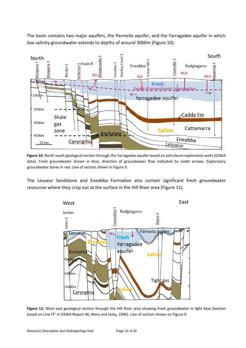
The basin contains two major aquifers, the Parmelia aquifer, and the Yarragadee aquifer in which low salinity groundwater extends to depths of around 3000m (Figure 10).
Figure 10. North south geological section through the Yarragadee aquifer based on petroleum exploration wells (GSWA data). Fresh groundwater shown in blue, direction of groundwater flow indicated by violet arrows. Exploratory groundwater bores in red. Line of section shown in Figure 9.
The Lesueur Sandstone and Eneabba Formation also contain significant fresh groundwater resources where they crop out at the surface in the Hill River area (Figure 11).
Figure 11: West east geological section through the Hill River area showing fresh groundwater in light blue (Section based on Line FF’ in GSWA Report 46, Mory and lasky, 1996). Line of section shown on Figure 9.

Resource Description and Hydrogeology final Page 16 of 32
These fresh, meteoric, groundwater systems are replenished mainly by rainfall falling on the outcrop of the aquifers. Groundwater flows slowly to discharge offshore at flow rates of around several metres per year, and groundwater ages sampled from bores range from thousands to tens of thousands of years. At depth, generally below the Cadda Formation, a continuous aquiclude, groundwater is saline and stagnant, and the brines may reflect sequestered seawater from previous periods of inundation.
Superficial aquifer Superficial sands and limestone underlie the coastal plain and form an aquifer up to 25m thick. Groundwater is recharged by rainfall, by ephemeral streams which pond up against the Spearwood Dunes, and there is also upward discharge in places from the underlying confined aquifers. The Tamala Limestone, making up the Spearwood Dunes, exhibits karst features, with caves, and underground river channels. In the Bassendean Dune System, the water table is generally shallow, supporting wetlands and phreatophytic vegetation, but some areas are unsaturated, with the water table in the Mesozoic aquifers below, and many of the ephemeral wetlands are perched, and supported by streamflow. Groundwater generally becomes increasingly brackish to saline northwards, and saline groundwater occurs near the coast associated with salt lakes. Fresh groundwater resources are limited, but are used for Jurien and Cervantes water supply. Parmelia aquifer The Cretaceous Parmelia aquifer occurs below the Dandaragan Plateau (Figure 11), between the Dandaragan Scarp and the Darling and Urella Faults. It is up to 400m thick and is bounded below by the Otorowiri Siltstone, and in the south is overlain by the Leederville aquifer and the Kardinya Shale aquiclude. It contains low salinity groundwater, except along the eastern margin, close to the Darling Fault especially along the chain of salt lakes along the Coonderoo River where groundwater discharge is inferred to take place. Groundwater recharge takes place directly from rainfall infiltrating the sandy soils. Groundwater flows south from a groundwater divide west of Coorow, and to the north of this, discharge occurs to the Arrowsmith River and springs along the Dandaragan Scarp. The aquifer is used for town supply to Mingenew, Morawa-Perenjori, Three Springs, Carnamah/Coorow, Dandaragan and Moora, for stock and domestic water on farms, and for irrigation. Yarragadee aquifer The Jurassic Yarragadee Formation is the most important and widespread aquifer in the Northern Perth Basin extending from the Metropolitan area almost as far as the Greenough River (Figure 10). It is up to 3000m thick, and crops out between the coastal plain and the Dandaragan Scarp (except in the Hill River area where older formations occur), and extends below the coastal plain, and to the Darling and Urella Faults in the east below the Otorowiri aquiclude. Groundwater is recharged by rainfall and local runoff on the outcrop, and groundwater flows north from a groundwater divide near the Hill River to eventually discharge offshore south of Dongara, and south to discharge to the ocean south of Ledge Point. Locally, north of the Irwin River, groundwater flow is southwestward

Resource Description and Hydrogeology final Page 17 of 32
towards the coast. Around Badgingarra, to the south and east of Eneabba, and on the Victoria Plateau north of the Irwin River, the water table is deep, as much as 150m below surface. Wireline logs from oil exploration wells indicate that low salinity groundwater extends to depths of at least 1500m in the Yarragadee aquifer in places, well below the 760m depth of groundwater exploration. Commonly there is a sharp increase in salinity several hundred metres above the base of the formation, or at the boundary with the underlying Cadda Formation. This salinity increase may indicate a substantial decrease in permeability in the lower parts of the Yarragadee Formation. Groundwater in the upper part of the aquifer is generally fresh to marginal, but locally saline close to the Arrowsmith and Irwin Rivers. Where the aquifer is confined by the overlying Otorowiri Formation, the groundwater is brackish, becoming progressively saline eastwards. Groundwater from the Yarragadee aquifer is used for town water supply to Geraldton, Dongara, Eneabba, and Badgingarra, by the mineral sand industry at Cooljarloo and Eneabba, and for stock and domestic supply, and irrigated agriculture. Cattamarra, Eneabba and Lesueur aquifers The Early Jurassic Cattamarra and Eneabba Formations and the underling Triassic Lesueur Sandstone crop out at the surface in the Hill River area where they are relatively intensely faulted. In the outcrop in the Hill River area, groundwater in the Lesueur and Eneabba aquifers is generally fresh, but the Cattamarra aquifer contains mainly brackish to saline groundwater. In the Dandaragan Trough, below the Cadda Formation, electric logs and drill stem tests from petroleum exploration wells indicate high salinity, reaching 50 000 milligrams per litre (mg/L), indicating that the groundwater is stagnant, and not connected to a meteoric groundwater flow system. Groundwater from the Lesueur aquifer is used for Greenhead-Leeman town water supply, and has been investigated for future supply to Jurien. Groundwater from the Eneabba and Lesueur aquifers is also used for irrigation, and stock and domestic supply. On farms south west of Eneabba, where the Cattamarra aquifer is close to the surface, groundwater is commonly brackish to saline. The Triassic Kockatea Shale occurs directly below the 25m thick superficial aquifer at Jurien, and was reported to contain saline groundwater. East of the Beagle Fault, it is directly overlain by the fresh water bearing Lesueur Sandstone and Woodada Formation. Progressively eastwards, where the Yarragadee occurs at the surface, the Kockatea Shale underlies saline groundwater in the Cattamarra, Eneabba and Lesueur aquifers. Permian aquifers The Permian High Cliff Sandstone and Irwin River Coal Measures reach the surface north of the Greenough River, where they are local sources of low salinity groundwater. To the south, in the Dandaragan Trough, where they are confined by the Kockatea Shale, groundwater is saline.

Resource Description and Hydrogeology final Page 18 of 32
Canning Basin Resource The onshore Canning Basin covers an area of about 530,000 km2 in central-northern Western Australia, and extends offshore for a total basin area of more than 640,000 km2, of which 110 000 km2 is in State waters (Figure 12).
Petroleum exploration activity began in the Canning Basin in the early 1920s. Since then, 287 onshore and 14 offshore wells have been drilled in the region, accompanied by the acquisition of 175,591 km of 2D seismic data, of which about half lies onshore. Figure 13 and 14 shows the potentially prospective shale oil and gas in the Canning Basin.
Four petroleum systems have been identified in the onshore Canning Basin. Proven Ordovician source-rock intervals exist within the Goldwyer and Bongabinni Formations. Source-rock intervals in the Devonian include the fossiliferous Gogo Formation. The first commercial discovery in this basin was the Blina oilfield. The Lower Carboniferous section includes effective source rocks in the Laurel and Anderson Formations, which likely sourced the Lloyd 1, West Kora 1, and Point Torment 1 hydrocarbon accumulations. Permian sequences include globally distributed source rocks in the upper Grant Group shales and in the Noonkanbah Formation.
The Goldwyer Formation lies at an average depth of 1330m and has an average thickness of 350m. It is thickest in the northern half of the Canning Basin, but may also be prospective in the Great Sandy Desert and in the southeast of the basin. This area remains highly underexplored.
The Carboniferous Laurel and Devonian Gogo Formations could possess additional shale gas potential in the deeper parts of the Canning Basin.
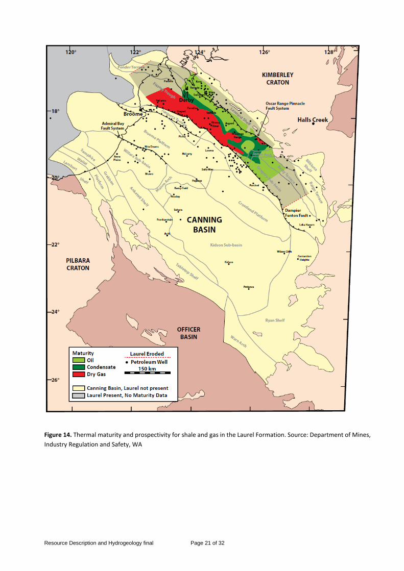
DMIRS estimates that the Canning Basin contains 27 700 Gm3 (1000 Tcf) of shale gas, of which about 2000–4200 Gm3 (73–147 Tcf) may be recoverable. Tight gas resources also exist in the basin, notably in the Laurel Formation.

Resource Description and Hydrogeology final Page 19 of 32
Figure 12. The Canning Basin, showing tectonic units, pipelines, fields and petroleum wells. Source: Department of Mines, Industry Regulation and Safety, WA.

Resource Description and Hydrogeology final Page 20 of 32
Figure 13. Thermal maturity and prospectivity for shale oil and gas in the Goldwyer Formation. Source: Department of Mines, Industry Regulation and Safety, WA
Resource Description and Hydrogeology final Page 21 of 32
Figure 14. Thermal maturity and prospectivity for shale and gas in the Laurel Formation. Source: Department of Mines, Industry Regulation and Safety, WA

Resource Description and Hydrogeology final Page 22 of 32
Canning Basin Regional Hydrogeology Detailed groundwater studies have been carried out only in the extreme south west (West Canning Basin), along the coast, around Broome (Dampier Peninsula and LaGrange Subarea), near Derby, and along the Fitzroy River. Elsewhere conditions are inferred from pastoral bores in the Fitzroy Trough and along the coast, and inland from widely spaced petroleum exploration wells and shallow bores and wells (Laws, 1991b). The basin contains some 10km of sediments ranging in age from Ordovician to Cretaceous, and can be subdivided into the Fitzroy Trough and Gregory Sub-basin (extending south east from Broome and encompassing the Fitzroy River Basin) and the Kidson and Willara Sub-basins, which underlie the Great Sandy Desert. Broome Sandstone aquifer The Cretaceous Broome Sandstone aquifer extends along the entire coast from the De Grey River to Cape Leveque, and inland by up to 150km (Figure 15 and 16). It includes all the Cretaceous formations in that area stratigraphically above the Jurassic Jarlemai Siltstone. The aquifer generally thickens towards the coast, reaching a maximum thickness of around 250m. The Broome Sandstone is an unconfined aquifer, recharged directly from rainfall and conformably overlies the largely impermeable Jarlemai Siltstone. In the centre of the Dampier Peninsula (Figure 17 and 18), the watertable is deep, exceeding 100m below surface (Laws, 1991a). Groundwater is generally fresh, with salt water interfaces along the coast and around Samphire Marsh and Roebuck Plains where groundwater discharge supports springs and phreatophytic vegetation. The aquifer is used for Broome town water supply, community water supply, for stock watering, and increasingly for irrigation on pastoral leases north of Samphire Marsh. Cretaceous sediments equivalent to the Broome Sandstone crop out in the Kidson Sub-basin (Figure 15) and may contain low salinity groundwater, but there is little information on the extent of fresh groundwater. Wallal Sandstone aquifer The Jurassic Wallal Sandstone underlies the Jarlemai Siltstone in the west of the basin, and crops out beneath the Great Sandy Desert (Figure 15 and 16). It unconformably overlies various formations of Permian age. Together with the overlying Alexander Formation, it forms a 500m thick aquifer, unconfined inland, and confined along the coast where it is overlain by the Jarlemai Siltstone and Broome Sandstone (Figure 16 and 18). It is recharged by direct rainfall on the outcrop, and groundwater flow is towards the coast, or locally to King Sound. Groundwater discharge is presumably a considerable distance offshore, as the potentiometric head along the coast is artesian (as at Broome), and up to 30m above sea level at Cape Keraudren. Groundwater in the extreme southwest of the basin is low, but salinity increases to brackish north of Samphire Marsh, and is around 2500 mg/L at Broome. The aquifer was investigated in the West Canning Basin for supply to Port Hedland, and is now being increasingly used between the De Grey River and Samphire Marsh for irrigation. Brackish groundwater is used for pastoral purposes on the east of the Dampier Peninsula.

Resource Description and Hydrogeology final Page 23 of 32
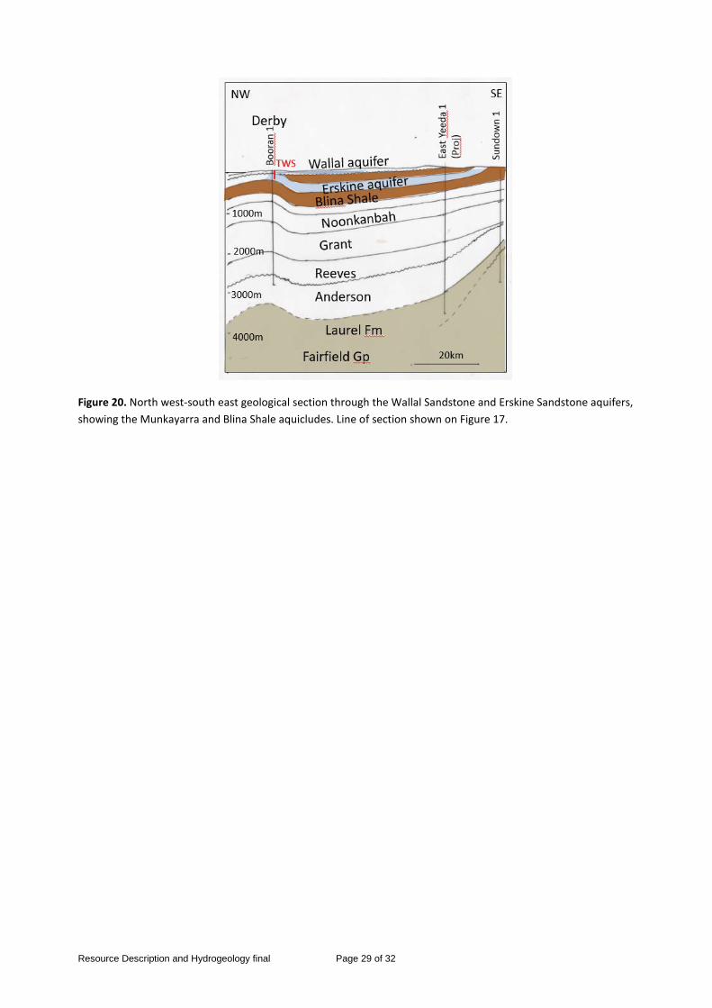
Erskine Sandstone aquifer The Triassic Erskine Sandstone occupies a syncline extending south east of Derby (Figure 19 and 20). It is in contact with an overlying outlier of Wallal Sandstone at Derby where the intervening Munkayarra Formation is absent, and is bounded beneath, and around the margin by the underlying Blina Shale (Laws and Smith, 1989; Smith, 1992). Groundwater is recharged on the outcrop of the aquifer, with groundwater flow towards King Sound. Seawater interfaces occur in the aquifer around the Derby peninsula. The Erskine aquifer is used for Derby water supply and small scale horticulture, and the Wallal aquifer supports irrigation at Mowanjum, near Derby. Shallow groundwater in areas underlain by Blina Shale is generally saline. Liveringa Group The Permian Liveringa Group contains 600m of various sandstone aquifers and fine grained formations, and crops out in the Fitzroy Trough. It overlies the largely impermeable Noonkanbah Formation. Groundwater varies in salinity from marginal to brackish and is used for stock and domestic supply, and has been used for irrigation at Camballin. Grant Group and Poole Sandstone The Permian Poole Sandstone and Grant Group together form a major aquifer up to 2100m thick. They crop out as inliers in the Fitzroy Trough, in the Grant and St Georges Ranges, and underlie the greater part of the Great Sandy Desert, stratigraphically below the Noonkanbah Formation. In the Great Sandy Desert the Poole and Grant Group are in contact with overlying Cretaceous sandstones. In the Fitzroy Trough, groundwater is generally low salinity, but in the Willara and Kidson Sub-basins groundwater in the Grant Group is as much as 37 000 mg/L (NaCl eq.) n Munro 1 (Ghassemi et al., 1991). Carboniferous and Devonian and Ordovician In the eastern Fitzroy Trough there are various sandstones and the Devonian limestone reefs which generally contain fresh groundwater and probably represent local flow systems, discharging to the major rivers. Very little is known of the aquifers stratigraphically below the Grant Group in the Kidson and Willara Sub-basins. Ghassemi et al. (1991) quote salinities of 5500 – 27000 mg/L (NaCl eq.) in the Tandalgo Formation in Kidson 1 (Figure 16). A factor affecting groundwater salinity in the Kidson and Willara Sub-basins is the dissolution of evaporites, particularly where salt domes have formed and intruded into overlying formations (Ghassemi et al, 1991). Fitzroy alluvial aquifer An alluvial aquifer, consisting of up to 25m of sands and gravels, stretches some 275km along the Fitzroy River. The alluvium is recharged by river flow in the wet season, and discharges to river pools in the dry season. Discharge also takes place through the alluvium in the dry season from the underlying Permian aquifers, with groundwater of differing salinity (Harrington et al., 2011).

Resource Description and Hydrogeology final Page 24 of 32
Groundwater discharge from the Liveringa and Grant Groups is relatively low salinity, but from the Noonkanbah Formation, it is brackish. Groundwater from these confined aquifers is critical in maintaining the pools and their associated ecosystems at the end of the dry season. The hydrogeology of the alluvium has not been investigated, despite having been suggested as a major water source for local irrigation and even a canal supplying the Perth Region. Mandora and Percival Paleodrainages The Great Sandy Desert is traversed by paleodrainages representing the courses of what were major rivers. These depressions now contain shallow calcrete aquifers and salt lakes, which discharge shallow groundwater, and lead to very high groundwater salinity. The Mandora Paleodrainage is probably responsible for the brackish groundwater in the Wallal Sandstone aquifer north of Samphire Marsh. The fresh-water springs around the lakes are critical traditional water sources, and springs and shallow bores and wells in the paleovalleys supply community needs.
Figure 15. Canning Basin showing fresh groundwater (blue) in the Broome and Wallal aquifers (fresh water in other aquifers not shown).

Resource Description and Hydrogeology final Page 25 of 32
Figure 16. North west – south east geological section through the Willara and Kidson Sub-basins showing fresh groundwater in the Broome and Wallal aquifers (after Ghassemi et al., 1991).

Resource Description and Hydrogeology final Page 26 of 32
Figure 17. Extent of fresh water in Broome Sandstone aquifer on the Dampier Peninsula, direction of groundwater flow indicated by violet arrows.

Resource Description and Hydrogeology final Page 27 of 32
Figure 18. West-north east geological section showing fresh groundwater in the Broome Sandstone, the underlying confined Wallal sandstone aquifer and the Laural Formation at depth (GSWA data). Broome town water supply TWS, and artesian bores indicated. Line of section shown on Figure 17.

Resource Description and Hydrogeology final Page 28 of 32
Figure 19. Extent of fresh groundwater (light blue) in the Wallal and Erskine Sandstone aquifers at Derby, direction of groundwater flow indicated by violet arrows.
Resource Description and Hydrogeology final Page 29 of 32
Figure 20. North west-south east geological section through the Wallal Sandstone and Erskine Sandstone aquifers, showing the Munkayarra and Blina Shale aquicludes. Line of section shown on Figure 17.

Resource Description and Hydrogeology final Page 30 of 32
Onshore Southern Carnarvon Basin Resource The onshore, Southern Carnarvon Basin has seen minimal exploration compared to the adjoining Perth and Northern Carnarvon Basins. The Southern Carnarvon basin extends west from the Precambrian shield to the offshore Perth and Northern Carnarvon basins, and covers approximately 200,000 km2 (Figure 21).
The northerly portion of the Southern Carnarvon Basin is composed of two principal structural elements: the Gascoyne Platform to the west, and the Merlinleigh and Byro Sub-basins to the east. The Paleozoic section is up to 7km thick and is covered by Triassic rocks in the north. Northerly and northwesterly-trending faults are also present.
Petroleum exploration commenced in the Southern Carnarvon Basin in the 1930s. West Australia Petroleum Pty Ltd was the first company with serious exploration programs in the 1950s and 1960s, following its oil discovery at Rough Range. After early exploration proved non-commercial, the main exploration activity moved north to the offshore Northern Carnarvon Basin. To date, 105 onshore and five offshore wells are drilled in the Southern Carnarvon Basin. No fields or accumulations have yet been discovered.
DMIRS has assessed the shale gas potential for three formations in the Merlinleigh Sub-basin to contain 2700 Gm3 (95 Tcf) of shale gas, of which about 110–250 Gm3 (4–9 Tcf) may be recoverable.
Carnarvon Basin Regional Hydrogeology Potential shale gas sources in the Merlinleigh and Byro Sub-basins along the eastern margin of the Carnarvon Basin are the black shales in the Permian Byro and Moogooloo Groups. The main aquifers in that part of the basin are the Permian Mallens and Moogooloo Sandstones. These aquifers generally contain brackish to saline groundwater, and apart from pastoral use, have only been used to supply construction water for the Dampier to Perth natural gas pipeline. Recent drilling in the Byro Sub-basin for water supply to the proposed Jack Hills iron ore mine has indicated significant resources of brackish groundwater in Permian sandstones. During construction of pastoral bores in this region, it was noted that flammable gas was associated with drilling in the black shales of the Byro Group, which are stratigraphically above the Moogooloo and Mallens Sandstones (Condit, 1935). Where the Byro Group underlies the coastal plain between the Lyndon and Yannarie Rivers, the main aquifer is the overlying Cretaceous Birdrong Sandstone. This is commonly artesian and supplies brackish to saline groundwater for stock. At the surface, the flood plain sediments are fine-grained silt and clay and are not a significant aquifer (Allen, 1988).

Resource Description and Hydrogeology final Page 31 of 32
Figure 21. The Southern Carnarvon Basin, showing tectonic units, pipelines and petroleum wells. Source: Department of Mines, Industry Regulation and Safety, WA

Resource Description and Hydrogeology final Page 32 of 32
References Australian Water Resources Council, 1988, Guidelines for the preparation of Australian hydrogeological maps. Water Management Series 13. Allen, A.D., 1988, Groundwater, in Geology of the Carnarvon Basin. Western Australia, Geological Survey, Bulletin 133, p. 237-244. Condit, D.D., 1935, Oil possibilities in Northwest District, Western Australia. Economic Geology v.30, p. 860-878. Department of Water, 2017, Northern Perth Basin: Geology, hydrogeology and groundwater resources, Hydrogeological Bulletin HB1. Geological Survey of Western Australia, 1989, Hydrogeological map of Western Australia 1:2 500 000. Ghassemi, F., Ferguson, J. and Etminan, H., 1991, Hydrogeology of deep aquifers in the Canning Basin Western Australia. Proceedings of the International Conference on Groundwater in Large Sedimentary Basins, Perth 9-13 July 1990, p. 59-69, Australian Water Resources Council. Harrington, G., Stelfox, L., Gardner, P., Davies, P., Doble, R. and Cook, P., 2011. Surface water- groundwater interactions in the lower Fitzroy River, Western Australia. CSIRO Water for a Healthy Country Flagship Report Series ISSN: 1835-095X. Laws, A.T., 1991a, Explanatory notes on the Broome 1:250 000 Hydrogeological sheet. Western Australia, Geological Survey, Hydrogeological Series. Laws, A.T., 1991b, Outline of the groundwater resource potential of the Canning Basin, Western Australia. Proceedings of the International Conference on Groundwater in Large Sedimentary Basins, Perth 9-13 July 1990, p. 47-58, Australian Water Resources Council. Laws, A.T. and Smith, R.A., 1989, The Derby regional groundwater investigation, 1987. Western Australia, Geological Survey Record 1989/12. Mory, A.J. and Iasky, R.P., 1996, Stratigraphy and structure of the onshore northern Perth Basin, Western Australia. Western Australia, Geological Survey, Report 46. Mory, A.J. and Haines, P.W., 2013, A Paleozoic Perspective of Western Australia. Western Australia, Conference Paper. Smith, R.A., 1992, Derby SE51-07 1:250 000 Hydrogeological sheet. Western Australia, Geological Survey, Hydrogeological Series. WAERA, 2012, Whicher Range tight gas sands study. Western Australia, Geological Survey.