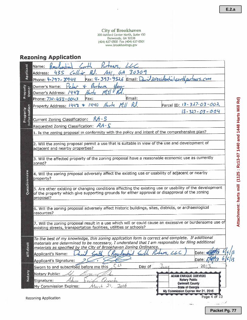
Residential South Partners Harts Mill Rezoning: 1440 and 1448 Harts Mill Road
20
Page 1 MEMORANDUM MEETING OF: August/07/2013 DISTRICT/COMMITTEE:Planning Commission SUBMITTING DEPARTMENT: Community Development ISSUE/AGENDA ITEM TITLE: Rz13-07: Residential South Partners, LLC, Seeks the Following: Rezoning of 2.92 Acres Located at 1440 and 1448 Harts Mill Road, Atlanta GA 30319, from R-A5c to R-A5c (A Change to Previously Approved Conditions) to Allow for the Construction of Twelve (12) Single Family Detached Homes. BACKGROUND/SUMMARY: Location Map BACKGROUND The subject site is currently two adjacent lots, owned in common, totaling 2.92 acres. The lots E.2 Packet Pg. 72
-
Upload
the-brookhaven-post -
Category
Documents
-
view
298 -
download
0
description
Residential South Partners Harts Mill Rezoning: 1440 and 1448 Harts Mill Road
Transcript of Residential South Partners Harts Mill Rezoning: 1440 and 1448 Harts Mill Road

Page 1
MEMORANDUM
MEETING OF: August/07/2013
DISTRICT/COMMITTEE:Planning Commission
SUBMITTING DEPARTMENT: Community
Development
ISSUE/AGENDA ITEM TITLE:
Rz13-07: Residential South Partners, LLC, Seeks the Following: Rezoning of 2.92 Acres
Located at 1440 and 1448 Harts Mill Road, Atlanta GA 30319, from R-A5c to R-A5c (A Change
to Previously Approved Conditions) to Allow for the Construction of Twelve (12) Single Family
Detached Homes.
BACKGROUND/SUMMARY:
Location Map
BACKGROUND
The subject site is currently two adjacent lots, owned in common, totaling 2.92 acres. The lots
E.2
Packet Pg. 72

Rezoning Ordinance (ID # 1125) Meeting of August 7, 2013
Page 2
are located at the north side of Harts Mill Road, at its intersection with Bubbling Creek Road. On
the far north side of the larger of the two lots is a two-story single family home with an accessory
one-story detached garage to its east. The home and garage take access from Harts Mill Road by
a driveway east of Bubbling Creek Road. The lots are fully wooded, generally increasing in
elevation towards the north, but with a pronounced low area on the southwest, essentially
comprising the entirety of the smaller of the two lots.
These lots were rezoned in 2002 by the current owner/occupant to R-A5c (Single Family
Residential, Conditional). That zoning was undertaken so that the properties could be subdivided
from two lots into ten lots, including the existing home which was to remain as a part of that
original zoning approval. The potential development density of the current zoning is 3.42
dwelling units per acre. The current proposal is to amend that earlier site plan with a new site
plan that creates 12 lots, including the demolition of the existing home and garage. The net
addition to the plan will be two additional home sites, for a revised dwelling unit density of 4.11
dwelling units per acre. The site is surrounded by single-family detached homes immediately
adjacent, zoned R-A5 (Single Family Residential District) to the west, north and east, and R-75
(Single Family Residential District) to the south (across Harts Mill Road).
SITE PLAN ANALYSIS
The submitted site plan indicates the demolition of the existing home and accessory detached
garage, to allow for the construction of 12 new single family detached homes. All of the
proposed new homes will face and take access from a new interior street, proposed to meet Harts
Mill Road at its intersection with Bubbling Creek Road. All of the new lots conform to the terms
of the zoning ordinance for lot area, lot width and setbacks.
ADJACENT LANDS ANALYSIS
Direction Zoning Current Land Use Current Density Future Land Use
North R-A5 Single family
residential, attached
2.1 DU/Acre Suburban
East R-A5 Single family
residential, detached
4.3 DU/Acre Suburban
South R-75 Single family
residential, detached
and attached
2.1 DU/Acre Suburban
West R-A5 Single family
residential, attached
2.1 DU/Acre Suburban
REVIEW STANDARDS AND FACTORS
E.2
Packet Pg. 73

Rezoning Ordinance (ID # 1125) Meeting of August 7, 2013
Page 3
1. Whether the zoning proposal is in conformity with the policy and intent of the
Comprehensive Plan. This property is listed on the future land use map in DeKalb County’s
Comprehensive Plan 2005-2025 as ‘Suburban Character’. The Comprehensive Plan describes
the Suburban Character Area as an area where typical types of suburban residential
subdivision development have occurred and where pressures for the typical types of suburban
residential subdivision development are greatest. The Plan indicates that the intent of the
Suburban Character Area is to recognize those areas of the county that have developed in
traditional suburban land use patterns while encouraging new development to have increased
connectivity and accessibility. The proposed density for areas of this type is up to 8 dwelling
units per acre as described in the Plan policy. Of note, the property is also located in close
proximity to -but not within- a character area described as ‘Conservation/Greenspace’, due to
the presence of a stream to the north of the property. This character area is summarized in the
Comprehensive Plan as “Primarily undeveloped and environmentally sensitive lands not
suitable for development and areas of protected open space that follow linear features for
recreation, and conservation. It also includes lands used for active recreational purposes that
provide a wide range of activities.”
2. Whether the zoning proposal will permit a use that is suitable in view of the use and
development of adjacent and nearby properties? This proposal for a one-family detached
residential use planned for this development site is entirely consistent with the policy intent
of the Plan, as the Plan forecasts residential uses in this character area of the city, making
accommodations for homes to be built at a maximum density of eight units per acre.
3. Whether the property to be affected by the zoning proposal has a reasonable economic
use as currently zoned? Both the Comprehensive Plan and Zoning Ordinance make
provisions that allow for greater development density of the subject properties. The current
approved development density allows for economic use; however, the proposed density of
4.11 units per acre is more in line with suburban development density in this area of the city
and is a more reasonable economic use for the subject property.
4. Whether the zoning proposal will adversely affect the existing use or usability of
adjacent or nearby property? The proposal is to build single family detached infill
housing, which is exactly the same land use pattern that abuts the project to the east, at a
comparable development density. It appears the proposed development will not adversely
affect the area.
5. Whether there are other existing or changing conditions affecting the use and
development of the property which gives supporting grounds for either approval or
disapproval of the zoning proposal? As noted in item #4 above, the existing land use
pattern to the east provides additional supporting grounds for approving the zoning proposal.
6. Whether the zoning proposal will adversely affect historic buildings, sites, districts, or
archaeological resources? There are no such known historic buildings, sites, districts or
E.2
Packet Pg. 74

Rezoning Ordinance (ID # 1125) Meeting of August 7, 2013
Page 4
archaeological resources identified, or known by staff, to be on or near this property.
7. Whether the proposal will result in a use which will or could cause an excessive or
burdensome use of existing streets, transportation facilities, utilities or schools? Harts
Mill Road carries east-west traffic through this part of the city, between Ashford-Dunwoody
and Road and Chamblee-Dunwoody Road. The applicant has proposed the addition of a
deceleration lane from westbound Harts Mill Road into the project, but the Public Works
Director has noted that with only the addition of 12 new homes, that improvement is not
required. Instead, staff would require that the applicant add new paving in front of the entire
road frontage, so that a new left turn lane from westbound Harts Mill onto southbound
Bubbling Creek could be constructed at some point in the future, thereby reducing a potential
point of conflict along this section of Harts Mill Road. Further, Pubic Works will require
additional right-of-way dedication so that a minimum distance of 12.5 feet from the back of
curb of any additional pavement, and that the sidewalk along Harts Mill be built five feet
wide with a two-foot beauty strip, per the current code.
The City Engineer’s office has no objections to the plan as submitted.
Brookhaven Police staff commented that this project should have no impact on current police
services and would not require any additional personnel. Staff also agree with the
requirement to plan for a future turn lane on Harts Mill at Bubbling Creek to address
concerns with traffic nearing that intersection with its proximity to Ashford Dunwoody Road.
The City of Brookhaven has indicated no concerns in the ability to provide services as a
result of the requested rezoning.
FISCAL IMPACT: (Budgeted – over or under) FINANCIAL IMPACT:
NONE
STAFF RECOMMENDATION:
Community Development Department Recommendation
Approval (Subject to Recommended Conditions) _____X______
Denial _____________
Should this application be approved, staff recommends the following conditions:
RECOMMENDED CONDITIONS
1. The site shall be developed in substantial accordance with the site plan entitled “Zoning
Plan for 1440 and 1448 Harts Mill Road” by Crescent View Engineering, LLC, received
E.2
Packet Pg. 75

Rezoning Ordinance (ID # 1125) Meeting of August 7, 2013
Page 5
June 05, 2013. Any future variances required, if authorized by the Zoning Board of
Appeals, may result in altering the site plan to the degree necessary to incorporate
revisions.
2. Developer/Owner shall install pavement along the Harts Mill Road frontage to
accommodate the future construction of a left turn lane from westbound Harts Mill Road
onto southbound Bubbling Creek Road.
3. The owner/developer shall re-construct the sidewalk on Harts Mill Road along the
development frontage, with five (5) feet of pavement width and a two (2) foot beauty
strip between the curb and sidewalk. The required improvement shall be installed prior
to the issuance of the first Certificate of Occupancy.
4. Developer/owner shall dedicate sufficient right-of-way to maintain twelve and one-half
(12 ½) feet of right-of-way behind the back-of-curb along the total property frontage
adjacent Harts Mill Road. This right-of-way shall be submitted to the City of Brookhaven
prior to the issuance of a development permit.
ATTACHMENTS:
ATTACHMENTS:
harts mill (PDF)
Harts Mill Site Plan 6-3-13 (1) (PDF)
E.2
Packet Pg. 76
E.2.a
Packet Pg. 77
Att
ach
men
t: h
arts
mill
(11
25 :
Rz1
3-07
144
0 an
d 1
448
Har
ts M
ill R
d)

E.2.a
Packet Pg. 78
Att
ach
men
t: h
arts
mill
(11
25 :
Rz1
3-07
144
0 an
d 1
448
Har
ts M
ill R
d)

E.2.a
Packet Pg. 79
Att
ach
men
t: h
arts
mill
(11
25 :
Rz1
3-07
144
0 an
d 1
448
Har
ts M
ill R
d)

E.2.a
Packet Pg. 80
Att
ach
men
t: h
arts
mill
(11
25 :
Rz1
3-07
144
0 an
d 1
448
Har
ts M
ill R
d)

E.2.a
Packet Pg. 81
Att
ach
men
t: h
arts
mill
(11
25 :
Rz1
3-07
144
0 an
d 1
448
Har
ts M
ill R
d)

E.2.a
Packet Pg. 82
Att
ach
men
t: h
arts
mill
(11
25 :
Rz1
3-07
144
0 an
d 1
448
Har
ts M
ill R
d)

E.2.a
Packet Pg. 83
Att
ach
men
t: h
arts
mill
(11
25 :
Rz1
3-07
144
0 an
d 1
448
Har
ts M
ill R
d)
E.2.a
Packet Pg. 84
Att
ach
men
t: h
arts
mill
(11
25 :
Rz1
3-07
144
0 an
d 1
448
Har
ts M
ill R
d)

E.2.a
Packet Pg. 85
Att
ach
men
t: h
arts
mill
(11
25 :
Rz1
3-07
144
0 an
d 1
448
Har
ts M
ill R
d)

E.2.a
Packet Pg. 86
Att
ach
men
t: h
arts
mill
(11
25 :
Rz1
3-07
144
0 an
d 1
448
Har
ts M
ill R
d)

E.2.a
Packet Pg. 87
Att
ach
men
t: h
arts
mill
(11
25 :
Rz1
3-07
144
0 an
d 1
448
Har
ts M
ill R
d)

E.2.a
Packet Pg. 88
Att
ach
men
t: h
arts
mill
(11
25 :
Rz1
3-07
144
0 an
d 1
448
Har
ts M
ill R
d)

E.2.a
Packet Pg. 89
Att
ach
men
t: h
arts
mill
(11
25 :
Rz1
3-07
144
0 an
d 1
448
Har
ts M
ill R
d)

E.2.a
Packet Pg. 90
Att
ach
men
t: h
arts
mill
(11
25 :
Rz1
3-07
144
0 an
d 1
448
Har
ts M
ill R
d)

E.2.b
Packet Pg. 91
Att
ach
men
t: H
arts
Mill
Sit
e P
lan
6-3
-13
(1)
(11
25 :
Rz1
3-07
144
0 an
d 1
448
Har
ts M
ill R
d)