Residential Design Guide - South Bucks - Home · RESIDENTIAL DESIGN GUIDE . HOW TO USE THIS GUIDE :...
47
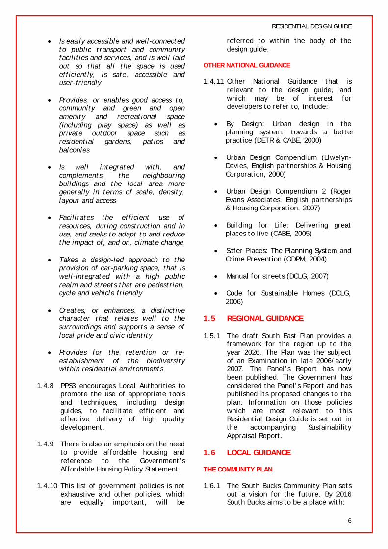
South Bucks District Council Residential Design Guide Supplementary Planning Document October 2008
Transcript of Residential Design Guide - South Bucks - Home · RESIDENTIAL DESIGN GUIDE . HOW TO USE THIS GUIDE :...

South Bucks District Council
Residential Design Guide Supplementary Planning Document
October 2008

RESIDENTIAL DESIGN GUIDE
HOW TO USE THIS GUIDE 2 5.5 Connections & Movement
5.6 Surveillance DESIGN FLOW CHART 3
5.7 Open Space
PART A: DESIGN PREPARATION 5.8 Density
1. INTRODUCTION 4 5.9 Parking
1.1 Why is a Residential Design Guide Needed? 5.10 Bicycle Stores
1.2 Status of the Document 5.11 Bin Stores
1.3 Who is the Document for? 6. BUILDING DESIGN 25
1.4 National Policy Background 6.1 Position of Building
1.5 Regional Guidance 6.2 Building Mass and scale
1.6 Local Guidance 6.3 Building Height
1.7 Consultation 6.4 Architecture
2. THE PRINCIPLES OF URBAN DESIGN 8 6.5 Elevational Treatment
2.1 By Design 6.6 Ancillary Buildings within the Residential Curtilage
2.2 Character 7. NATURAL ENVIRONMENT 30
2.3 Continuity and Enclosure 7.1 Biodiversity and Ecological Habitats
2.4 Quality of the Public Realm 7.2 Trees
2.5 Ease of Movement 7.3 Landscaping
2.6 Legibility 7.4 Hard Landscaping
2.7 Adaptability 7.5 Boundary Treatment
2.8 Diversity 7.6 Flooding
3. SELECTING THE SITE 10 8. SUSTAINABLE BUILDING 35
3.1 Site Designation 8.1 Sustainability
3.2 Designation and Characteristics of Surrounding 8.2 Energy
Area 8.3 Waste
3.3 Planning Policy 8.4 Sustainable Materials
3.4 Site History 8.5 Water
3.5 Infrastructure Requirements 8.6 Pollution Control
3.6 Is the Proposal Acceptable in Principle? 8.7 Livability & Lifetime Homes
4. SITE ANALYSIS 12 9. SUBMITTING A PLANNING APPLICATION 40 4.1 Why is a Site Analysis Needed?
9.1 Applications for Householder Extensions
4.2 Site Analysis Checklist and Plan 9.2 Pre-Application Advice & Fees
PART B: DESIGN PRACTICE 15 9.3 Design and Access Statements
5. URBAN STRUCTURE AND LAYOUT 16 9.4 Listed Building and Conservation Areas
5.1 A Comprehensive Approach 9.5 Other Requirements
5.2 Building Layout 9.6 Community Involvement
5.3 Spaces between Buildings 10. GLOSSARY 42
5.4 Passive Solar Design 11. INFORMATION RESOURCE 44
1

RESIDENTIAL DESIGN GUIDE
HOW TO USE THIS GUIDE
This guide is relevant to all new residential development of one of more dwellings. It is intended as a tool for both applicants and decision makers to secure well-designed and sustainable residential development within South Bucks.
The design guide is split into Part A - Design Preparation, and Part B – Design Practice. Each Part is split into a number of sections as outlined below. This guide should be read in conjunction with the saved policies in the South Bucks District Local Plan and other policies and guidance outlined in section 1.
PART A: DESIGN PREPERATION
1: INTRODUCTION
This section sets out the status of the document and the reasons behind its production, including policy background and the consultation process.
2: URBAN DESIGN PRINCIPLES
This section gives an overview of the principles of urban design and their importance in residential development.
These principles are taken from government design guidance set out in By Design (DETR & CABE, 2000) and should be qualities that all residential developments aspire to achieve, irrespective of scale.
3: SELECTING THE SITE
This section sets out information which can be collected before a site visit is even conducted. For example, what are the relevant national and local planning policies relating to the site? What is the planning history?
This information can be gathered from sources such as the Council offices or via the Council website and may inform the applicant whether residential development is likely to be acceptable in principle.
PART B: DESIGN PRACTICE
4: SITE ANALYSIS
It is important that proposals reflect and respond to the context of the locality to ensure that they add to the quality of their surrounds.
This section sets out how to go about undertaking a site analysis and provides a checklist of those main considered when assessingdevelopment potential.
issues a
to site
be for
5-8: DESIGNING THE SITE
These sections set out the detailed design process, from the street layout to the intrinsic design of individual buildings.
This part of the design guide includes both general information and specific examples which will aid in the design of each individual scheme.
Throughout these sections checklists are provided to ensure that each stage of the design process has been followed through.
9: THE APPLICATION PROCESS
This section gives advice on discussing proposals with the Planning Authority, how to submit an application and the importance of design and access statements.
Throughout the guide illustrations will be used to help explain some of the important
design principles.
2
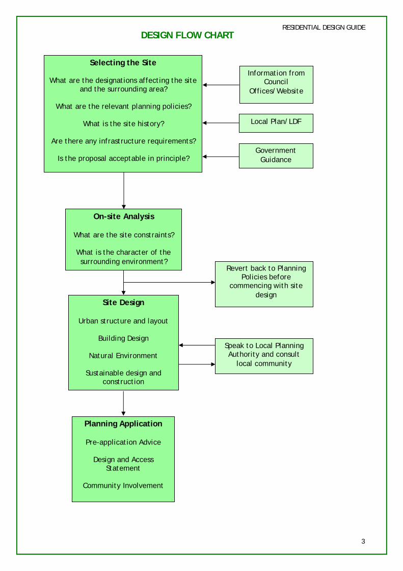
RESIDENTIAL DESIGN GUIDE DESIGN FLOW CHART
Selecting the Site
What are the designations affecting the site and the surrounding area?
What are the relevant planning policies?
What is the site history?
Are there any infrastructure requirements?
Is the proposal acceptable in principle?
On-site Analysis
What are the site constraints?
What is the character of the surrounding environment?
Site Design
Urban structure and layout
Building Design
Natural Environment
Sustainable design and construction
Planning Application
Pre-application Advice
Design and Access Statement
Community Involvement
Speak to Local Planning Authority and consult
local community
Local Plan/LDF
Government Guidance
Revert back to Planning Policies before
commencing with site design
Information from Council
Offices/Website
3
RESIDENTIAL DESIGN GUIDE
1. INTRODUCTION
1.1 WHY IS A RESIDENTIAL DESIGN GUIDE NEEDED?
1.1.1 South Bucks is a relatively small, principally semi-rural district, with tracts of high quality landscape throughout. Transport links to larger towns outside the district and into London are generally good and the quality of the environment is high. There is a demand to build new homes in this area, so it is essential that development is well designed to ensure that it respects and contributes positively to the character of the locality.
1.1.2 The guidance within this Supplementary Planning Document (SPD) will enable developers, architects, applicants and the public to understand the residential design standards that will be sought within the District.
1.1.3 It is considered that there are two key elements to good residential design:
URBAN DESIGN
1.1.4 Firstly, there is a need to ensure the existing character of the District is maintained and enhanced. In recent years there has been an increase in the number of planning applications submitted for new residential development, particularly those involving redevelopment at higher densities, in line with government advice.
1.1.5 Since much of the District is protected by Green Belt policies, most of the development that takes place comprises residential intensification within existing towns and villages. Residential intensification can have a significant impact on the character of both the immediate vicinity and the wider locality and therefore needs to be carried out in a way that will ensure good design of development which preserves the residential amenities of
neighbouring properties and enhances the character of the locality. Urban design not only relates to the way a place looks, but also to how it functions.
SUSTAINABLE DESIGN
1.1.6 In addition to new housing that follows good urban design principles and is visually attractive, this design guide will seek to ensure that all new residential development is sustainable.
1.1.7 In order to tackle climate change, carbon dioxide emissions need to be reduced. The built environment generally has a design life of 40-100 years, and this makes climate change a current rather than a future issue. In order to help communities adapt, planners, applicants, architects and developers need to take into account predicted climates over this century at the design stage of any new development, refurbishment or regeneration programme. There is need therefore, for urgent action to increase energy efficiency and reduce carbon dioxide emissions.
1.1.8 Energy efficiency can be achieved through the use of efficient design and layout of new housing, for example through passive solar design and sustainable construction. The use of renewable energy also has its part to play. This design guide will seek to ensure that all new residential development will incorporate high standards of energy efficiency and renewable energy sources.
1.2 STATUS OF THE DOCUMENT
1.2.1 The Residential Design Guide SPD will form part of the South Bucks Local Development Framework (LDF) by further defining and implementing the policies contained within the Development Plan Documents (DPDs).
1.2.2 Until the Core Strategy is adopted, the SPD will supplement the existing Local Plan policies that have been saved beyond 2007 and relevant
4
government policies. This is in line with advice in Planning Policy Statement (PPS) 12 (Local Development Frameworks). Whilst sustainability has been incorporated into sections 1-7 of the Guide, further information is included in section 8, although this must be treated as general advice rather than guidance since it does not supplement existing Local Plan or National Planning policy.
1.2.3 The SPD has been informed by community involvement and sustainability appraisal, and will be accorded appropriate weight in the determination of planning applications.
1.3 WHO IS THE DOCUMENT FOR?
RESIDENTIAL DESIGN GUIDE
relevant of which are highlighted below.
PPS1: DELIVERING SUSTAINABLE DEVELOPMENT
1.4.2 This policy document states, amongst other things, that one of the key principles that contribute to the delivery of sustainable development is the promotion of high quality inclusive design in the layout of new development.
1.4.3 PPS1 states that “Design which is inappropriate in its context, or which fails to take opportunities available for improving the character and quality of an area and the way it functions, should not be accepted” (PPS1, para. 13)
1.3.1 This guidance is aimed at all those interested or involved in residential development, including planners, developers, architects, applicants, consultees, councillors, parish councils and local residents and amenity groups.
1.3.2 The guidance should be understandable for the professional and the layman, and is intended to steer applicants through the policy background, appropriate design issues and design process.
1.3.3 Applicants are advised to work closely with the local community when designing a scheme. The Statement of Community Involvement sets out what the Council will expect potential developers to do to engage local people and others before submitting a planning application. This document can be viewed at the Council Offices or online at www.southbucks.gov.uk/environment /planning/local_development_framew ork/statement_of_community_involve ment
1.4 NATIONAL POLICY BACKGROUND
1.4.1 This design guide draws on and is consistent with national, regional and local policy and guidance, the most
PPS1 (SUPPLEMENT): PLANNING AND CLIMATE CHANGE
1.4.4 This sets out how planning should contribute to reducing emissions and stabilising climate change (mitigation) and take into account the unavoidable consequences (adaptation) of climate change.
1.4.5 In designing for environmental performance, planning authorities should, amongst other things, expect applicants to use landform, layout, building orientation, building design and landscaping to minimise energy consumption. Further considerations are emphasised such as biodiversity, waste management and sustainable urban drainage systems.
PPS3: HOUSING
1.4.6 This states that “good design is fundamental to the development of high quality new housing which contributes to the creation of sustainable mixed communities” (PPS3, para. 12)
1.4.7 PPS3 sets out clear points to consider when assessing design quality, such as the extent to which the proposed development: (para. 16)
5
RESIDENTIAL DESIGN GUIDE
• Is easily accessible and well-connected to public transport and community facilities and services, and is well laid out so that all the space is used efficiently, is safe, accessible and user-friendly
• Provides, or enables good access to, community and green and open amenity and recreational space (including play space) as well as private outdoor space such as residential gardens, patios and balconies
• Is well integrated with, and complements, the neighbouring buildings and the local area more generally in terms of scale, density, layout and access
• Facilitates the efficient use of resources, during construction and in use, and seeks to adapt to and reduce the impact of, and on, climate change
• Takes a design-led approach to the provision of car-parking space, that is well-integrated with a high public realm and streets that are pedestrian, cycle and vehicle friendly
• Creates, or enhances, a distinctive character that relates well to the surroundings and supports a sense of local pride and civic identity
• Provides for the retention or re-establishment of the biodiversity within residential environments
1.4.8 PPS3 encourages Local Authorities to promote the use of appropriate tools and techniques, including design guides, to facilitate efficient and effective delivery of high quality development.
1.4.9 There is also an emphasis on the need to provide affordable housing and reference to the Government’s Affordable Housing Policy Statement.
1.4.10 This list of government policies is not exhaustive and other policies, which are equally important, will be
referred to within the body of the design guide.
OTHER NATIONAL GUIDANCE
1.4.11 Other National Guidance that is relevant to the design guide, and which may be of interest for developers to refer to, include:
• By Design: Urban design in the planning system: towards a better practice (DETR & CABE, 2000)
• Urban Design Compendium (Llwelyn-Davies, English partnerships & Housing Corporation, 2000)
• Urban Design Compendium 2 (Roger Evans Associates, English partnerships & Housing Corporation, 2007)
• Building for Life: Delivering great places to live (CABE, 2005)
• Safer Places: The Planning System and Crime Prevention (ODPM, 2004)
• Manual for streets (DCLG, 2007)
• Code for Sustainable Homes (DCLG, 2006)
1.5 REGIONAL GUIDANCE
1.5.1 The draft South East Plan provides a framework for the region up to the year 2026. The Plan was the subject of an Examination in late 2006/early 2007. The Panel’s Report has now been published. The Government has considered the Panel’s Report and has published its proposed changes to the plan. Information on those policies which are most relevant to this Residential Design Guide is set out in the accompanying Sustainability Appraisal Report.
1.6 LOCAL GUIDANCE
THE COMMUNITY PLAN
1.6.1 The South Bucks Community Plan sets out a vision for the future. By 2016 South Bucks aims to be a place with:
6
• Falling crime and fear;
• Greater community pride and a sense of belonging;
• A sustainable and thriving community;
• Green space, character and the environment of the District preserved and enhanced;
• Public services flexible and meeting diverse needs or our community;
• Improving health and well-being, especially for those deprived groups; and
• Improvements in traffic congestion, road safety and public transport.
THE LOCAL PLAN
1.6.2 The South Bucks District Local Plan (adopted March 1999) contains a number of policies which relate to residential development both directly and indirectly. Many of these policies will be referred to within the design guide:
• Policy H7: Provision of Smaller Dwellings
• Policy H9: Residential Layout & Design
• Policy H10: Residential Areas of Exceptional Character
• Policy EP3: The Use, Design and Layout of Development
• Policy EP4: Landscaping
• Policy EP5: Sunlight and Daylight
• Policy EP6: Designing to Reduce Crime
• Policy R4: Public Open Space Provision in New Residential Developments
1.6.3 These policies are all “saved” and remain part of the Development Plan until they are superseded by policies in the Local Development Framework.
RESIDENTIAL DESIGN GUIDE
They should be read and used in conjunction with current national and regional policy and guidance.
1.7 CONSULTATION
1.7.1 In accordance with the legislative requirements of the Planning and Compulsory Purchase Act 2004 and associated regulations and guidance, this design guide has been prepared in parallel with an accompanying Sustainability Appraisal.
1.7.2 The Council has carried out its consultations in accordance with the Statement of Community Involvement.
7
RESIDENTIAL DESIGN GUIDE
2. THE PRINCIPLES OF URBAN DESIGN
2.1 BY DESIGN
2.1.1 “Urban design is the art of making places work for people. It includes the way places work and matters such as community safety, as well as how they look. It concerns the connections between people and places, movement and urban form, nature
ensure that adjacent buildings relate positively to one another, streets are connected and spaces complement one another.
2.2.3 The character of a place is built up of many elements including, landscapes, natural features, buildings, streets, street patterns, spaces, skylines, building forms and materials. New building designs must respond to all these elements.
and the built fabric, and the processes for ensuring successful towns and villages.” (DETR & CABE)
2.1.2 The objectives of urban design, as described in By Design can be summarised as follows:
• Character - a place with its own identity
• Continuity and enclosure – a place where public and private spaces are clearly distinguished
• Quality of the public realm – a place with attractive and successful outdoor areas
• Ease of movement – a place that is easy to get to and move through
• Legibility – a place that has a clear image and is easy to understand
• Adaptability – a place that can change easily
• Diversity - a place with variety and choice
2.2 CHARACTER
2.2.1
2.2.2
Principle: “To promote character in townscape and landscape by responding to and reinforcing locally distinctive patterns of development, landscape and culture” (DETR & CABE)
New residential development should respond to the existing layout of buildings, streets and spaces to
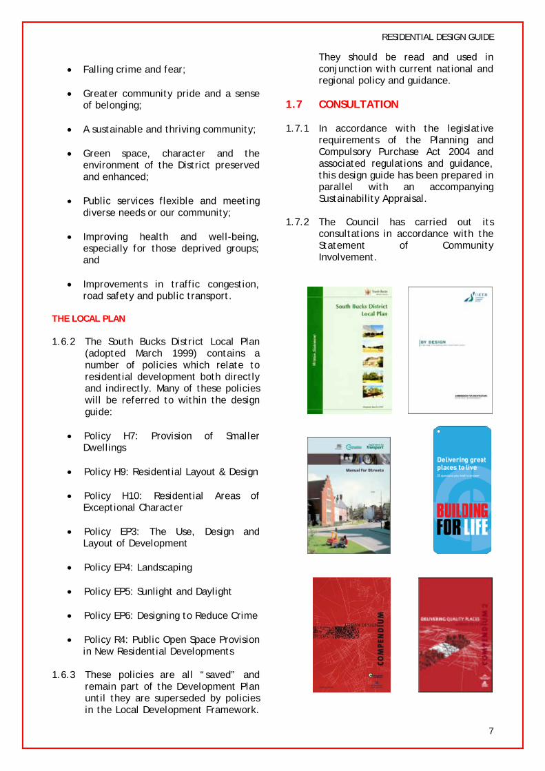
Fig. 2.3: Buildings overlooking the street (Denham Garden Village)
2.3.3 Private spaces, such as front or rear gardens, should be enclosed by the backs of buildings or other means of
Fig 2.2: Local distinctiveness (Beaconsfield)
2.3 CONTINUITY AND ENCLOSURE
2.3.1 Principle: “To promote the continuity of street frontage and the enclosure of space by development which clearly defines private and public areas.” (DETR & CABE)
2.3.2 New residential development should be designed to ensure that public spaces such as streets, footpaths and open spaces, are overlooked by windows or doors to habitable rooms. This creates an active frontage which not only makes a place more attractive and lively, but helps reduce crime.
8
RESIDENTIAL DESIGN GUIDE
enclosure so that there is a clear distinction between public and private space.
2.4 QUALITY OF THE PUBLIC REALM
2.4.1 Principle: “To promote public spaces and routes that are attractive, safe, uncluttered and work effectively for all in society, including disabled and elderly people.” (DETR & CABE)
2.4.2 These public outdoor spaces include any part of a development that is available for use by everyone such as streets, parks or squares. For these areas to be successful they need to be overlooked and well maintained.
2.5 EASE OF MOVEMENT
2.5.1 Principle: “To promote accessibility and local permeability by making places that connect with each other and are easy to move through, putting people before traffic and integrating land uses and transport.” (DETR & CABE)
2.5.2 A well-designed urban structure has a network of connected spaces and routes, for pedestrians, cyclists and vehicles. Proposed transport routes should reflect urban design qualities and not just traffic considerations.
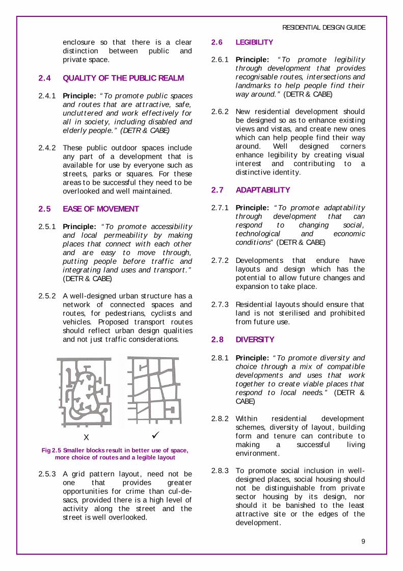
9 Fig 2.5 Smaller blocks result in better use of space,
more choice of routes and a legible layout
2.5.3 A grid pattern layout, need not be one that provides greater opportunities for crime than cul-de-sacs, provided there is a high level of activity along the street and the street is well overlooked.
2.6 LEGIBILITY
2.6.1 Principle: “To promote legibility through development that provides recognisable routes, intersections and landmarks to help people find their way around.” (DETR & CABE)
2.6.2 New residential development should be designed so as to enhance existing views and vistas, and create new ones which can help people find their way around. Well designed corners enhance legibility by creating visual interest and contributing to a distinctive identity.
2.7 ADAPTABILITY
2.7.1 Principle: “To promote adaptability through development that can respond to changing social, technological and economic conditions” (DETR & CABE)
2.7.2 Developments that endure have layouts and design which has the potential to allow future changes and expansion to take place.
2.7.3 Residential layouts should ensure that land is not sterilised and prohibited from future use.
2.8 DIVERSITY
2.8.1 Principle: “To promote diversity and choice through a mix of compatible developments and uses that work together to create viable places that respond to local needs.” (DETR & CABE)
2.8.2 Within residential development schemes, diversity of layout, building form and tenure can contribute to making a successful living environment.
2.8.3 To promote social inclusion in well-designed places, social housing should not be distinguishable from private sector housing by its design, nor should it be banished to the least attractive site or the edges of the development.
9
X

RESIDENTIAL DESIGN GUIDE
3. SELECTING THE SITE
Some of the information needed to be able to conduct a site analysis is publicly available either at the Council offices, on the website, or from a variety of other sources.
The following steps should be taken at the initial information gathering stage. These stages can usually be carried out prior to a site visit and may help inform as to whether the proposal is likely to be acceptable in principle. They should also help to inform the final design where a proposal is acceptable in principle.
3.1 SITE DESIGNATION
3.1.1 The designation of a site can be found within the South Bucks District Local Plan Proposals Map.
3.1.2 If the site is located within the Developed Area then residential development is normally acceptable in principle, subject to other saved Local Plan polices. The main policy to refer to is H9 (Residential Layout and Design)
(Developed Area)
3.1.3 In some circumstances, residential development may be acceptable in some other locations, having regard to the site circumstances and history. If the site you are considering does not lie within the Developed Area, or is contrary to other saved policies, you may wish to discuss the principle of redevelopment with a Planning Officer.
3.1.4 If the site is located within a Residential Area of Exceptional Character (RAEC), residential development may be acceptable in principle, however, it must reflect the prevailing character and density of the surrounding development and the locality. Refer to Local Plan policy H10 (Residential Areas of Exceptional Character) for further advice.
(RAEC)
3.1.5 If the site is located within a Green Belt Settlement (Policy GB3) then one for one replacement of dwellings and limited infilling maybe acceptable in principle.
(Green Belt settlement)
3.1.6 If the site is located with the open Green Belt then residential intensification is inappropriate. However, limited extensions to existing dwellings or replacement dwellings are acceptable in principle subject to the content of policies GB10 and GB11.
(Green Belt)
3.2 DESIGNATION & CHARACTERISTICS OF SURROUNDING AREA
3.2.1 Other than the designations listed in section 3.1, you should check whether your site is within or adjacent to any designated area or is constrained by another feature. Many of these constraints, but not all, are shown on the Local Plan Proposals Map and include:
• Conservation Areas;
• Flood zones and other areas of flooding;
• Historic Parks and Gardens;
• Rights of Way;
• Sites of Special Scientific Interest (SSSI);
• Other wildlife sites;
10

RESIDENTIAL DESIGN GUIDE
• Protected trees;
• Protected species;
• Scheduled Ancient Monuments;
• Archaeological sites;
• Listed buildings;
• Contaminated land; and
• Air Quality Management Areas
3.2.2 For nature designation sites and species records applicants can refer to the Bucks and Milton Keynes Environmental Record Centre (BMERC). For further information please see their website: http://www.bucksmkerc.org.uk/
3.3 PLANNING POLICY
3.3.1 Once the designation of the development site and the surrounding area has been determined, a review of the site in the context of the relevant Local Plan policies can take place.
3.4 SITE HISTORY
3.4.1 A review of previous applications and appeals relating to the site and its surroundings can be useful to help ascertain whether the development may be acceptable in principle or whether there are any other detailed matters that need to be taken into consideration.
3.5 INFRASTRUCTURE REQUIRMENTS
3.5.1 In some residential developments there is a need to ensure further infrastructure is put in place to meet the needs of the additional development, for example public open space, affordable housing, transport, or water and sewerage infrastructure. For further information on these issues please refer to:
• Policy R4 (Public Open Space Provision in New Residential Developments).
• Policy H5 (Affordable Housing)
• EP13 (Infrastructure Provision)
• TR5 (Accesses, Highways Works and Traffic Generation)
3.6 IS THE PROPOSAL ACCEPTABLE IN PRINCIPLE?
3.6.1 Working your way through each sub-section of this part of the design guide, should enable the designer to establish whether the site is suitable in principle for residential development.
3.6.2 If all stages have been satisfied then a context appraisal of the site and the surrounding area should be undertaken.
SECTION CHECKLIST SELECTING THE SITE
1 Is the site within an area where residential development is acceptable in principle?
2 Is the site adjacent to any other designated areas?
3 What are the planning policies relating to the site?
4 Are there any previous planning applications relating to the site?
5 Will the development result in additional infrastructure requirements?
6 Is the proposal likely to be acceptable in principle?
11
RESIDENTIAL DESIGN GUIDE
4. SITE ANALYSIS
4.1 WHY IS A SITE ANALYSIS NEEDED?
4.1.1 Once a site has been selected, a site analysis (sometimes known as context appraisal) is the next step in preparing a proposal for new residential development, whether it be for a single dwelling, or a major residential development.
4.1.2 The design of individual homes and entire neighbourhoods should be specific to context, based on an understanding of the way the local area looks and works. An understanding of the local context is fundamental to achieving good design.
4.1.3 New residential development should be well integrated with, and complement, the neighbouring buildings and the local area in terms of scale, mass, height and layout.
4.1.4 There are essentially two stages in undertaking a context appraisal:
AN ASSESSMENT OF THE SITE SURROUNDINGS:
4.1.5 An understanding of the nature of the wider context that surrounds the site in terms of both the natural and built environment
AN ASSESSMENT OF THE SITE ITSELF:
4.1.6 The specifics of the site and how this relates to the wider context
4.1.7 The size of the scheme will determine how extensive the analysis of the surrounding area should be. For example, in a scheme of one dwelling (either replacement or infill), the applicant may only need to assess the neighbouring plots and that part of the street where the proposed development would be located. Whereas for a major redevelopment, the applicant will need to assess the wider locality, including street networks and the surrounding natural and built environment.
4.1.8 The local design context will influence the density, plot/block layout, landscape, building details, materials and architectural style of the development proposal. This is not necessarily so that design proposals mimic existing development, but to ensure that the design has regard to the surrounding context.
4.2 SITE ANALYSIS CHECKLIST & PLAN
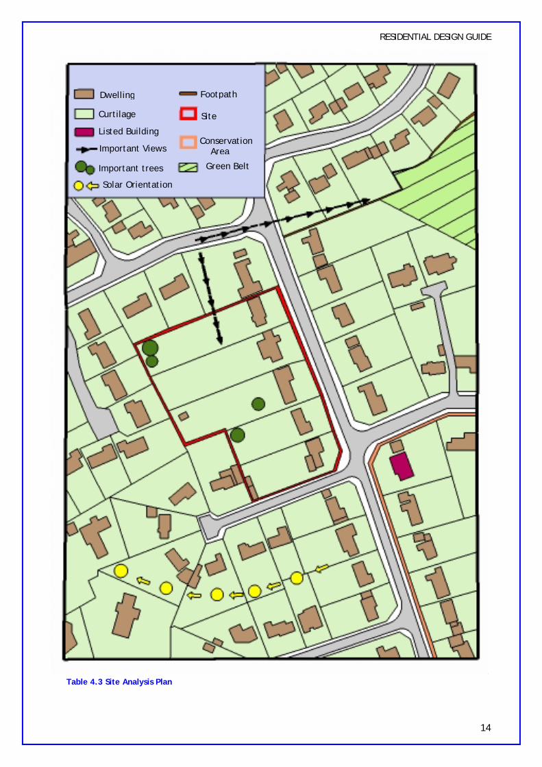
4.2.1 Some of the main considerations to be made when undertaking a context analysis are detailed in table 4.2. It has been set out in this way to provide a checklist for conducting a site survey. However it should be noted that this checklist is not necessarily exhaustive as factors will depend on the character of each individual site and its locality.
4.2.2 Applicants may wish to submit details of their site analysis as part of the Design and Access Statement with the planning application. It may be used as justification for the specific design proposals.
4.2.3 It is also advisable to create a plan which illustrates the analysis of the site and the surrounding area. For an example please see page 14.
12

Is the site within or adjacent to a designated area, e.g. a Conservation Area, the Green Belt, AONB etc?
RESIDENTIAL DESIGN GUIDE
ANY DETAILED APPRAISAL SHOULD COVER THE FOLLOWING POINTS:
LOCATION OF THE SITE Is the site in a prominent location?
What are the adjacent land uses?
Where are the access points to the site?
What are the existing movement patterns through and around the site? MOVEMENT NETWORKS &
ACCESSIBILITY How accessible is the site by public transport, foot, cycle and car?
How well is the site linked to shops and services?
What existing rights of way serve the site?
Landmarks and architecture CHARACTER OF SURROUNDING
BUILT ENVIRONMENT Relationship between buildings and streets
Prevailing Density
Important view corridors surrounding the site and important views to and from the site
NATURAL LANDSCAPE Waterways (including streams, ponds and other water features)
The existing and historic use of the site and land uses
Existing buildings
Topography of site
Trees and landscaping
Boundary treatments OTHER FEATURES OF
SURROUNDINGS & Dimensions of site SITE ITSELF
Orientation for solar gain
Potential wildlife habitats
Drainage/Natural drainage
Table 4.2 Site Analysis Checklist
13
RESIDENTIAL DESIGN GUIDE
Dwelling Footpath
Curtilage Site
Listed Building Conservation
Important Views Area
Important trees Green Belt
Solar Orientation
Table 4.3 Site Analysis Plan
14

PART B: DESIGN PRACTICE
This section of the design guide has been split into 4 main parts, all of which are as equally as important as the other. However depending on the size of the site and nature of the constraints identified at the site analysis stage, some sections may be more relevant than others.
5. URBAN STRUCTURE AND LAYOUT
Comprehensive approach Building layout Spaces between buildings Passive solar design Connections and Movement Surveillance Open space Density Parking Bicycle stores Bin stores
6. BUILDING DESIGN
Position of building Building mass and scale Building height Architecture Elevational treatment Ancillary buildings within the residential curtilage
7. NATURAL ENVIRONMENT
Biodiversity and ecological habitats Trees Landscaping Hard landscaping Boundary treatment Flooding
8. SUSTAINABLE BUILDING
Sustainability Energy Waste Sustainable materials Water Pollution control Liveability and lifetime Homes
RESIDENTIAL DESIGN GUIDE
Once a site has been selected, it has been determined that residential development is acceptable in principle and an analysis of the site and surroundings has been carried out, work can begin on designing the scheme.
Some readers would like to jump straight in at this point, however, if the design preparation has not been carried out, then it is likely that the final result will not be as good as it should be and it could result in the planning application being refused.
The following design objectives must be incorporated into each stage of the design process: A To encourage efficient and effective
use of land B To ensure a balanced mix of
dwelling types and sizes, including affordable housing
C To ensure new development reflects the accessibility of the location
D To ensure new development is in context with the existing character of the area in terms of built form, landscape and townscape
E To ensure development maintains the amenity and privacy of existing residential development
F To ensure new development incorporates well designed open space for occupiers
G To ensure development is well connected to the surroundings
H To protect important species and habitats and to encourage proposals to incorporate beneficial biodiversity or geological features within design
I To reduce crime through the creation of safer places to live
J To reduce the risk of flooding to people and property
K To ensure a clear definition between public and private areas
L To promote measures to mitigate and adapt to the forecast effects of climate change, including the use of renewable energy and sustainable construction and design
15

5. URBAN STRUCTURE & LAYOUT
The pattern or arrangement of buildings, streets and open space makes up the urban structure of a place and provides the foundations for detailed design of the constituent elements.
5.1 A COMPREHENSIVE APPROACH
5.1.1 There is a danger that sites which have not previously been specifically allocated for residential development (windfall sites) can sometimes become available for residential intensification and may be developed in a piecemeal fashion. This may result in other adjacent areas of land becoming un-developable in the future, or in development not making the best use of land. This is illustrated in fig 5.1a below.
Fig 5.1a Residential developments carried out in isolation
Fig 5.1b Residential development carried out comprehensively
5.1.2 It will be essential that a comprehensive approach is taken to ensure that the best use of land is secured, and which ensures that adjacent land is not sterilised or its potential for aggregate development is not reduced.
5.1.3 A further benefit of a more comprehensive approach is the opportunity to provide a greater
RESIDENTIAL DESIGN GUIDE
number of affordable housing units to create a more vibrant and mixed community and to provide for a recognised need. Policy H5 of the Local Plan sets out the Council’s requirements for affordable housing within the District. In due course this will be superseded by policy in the emerging Core Strategy. The requirements contained within this policy are supported by policies H7 and H9 which encourage the provision of smaller dwellings and also seek to ensure that housing sites are developed to their maximum potential. Development proposals which fail to comply with these policies and as a result fall short of the affordable housing threshold will not be looked upon favourably.
5.1.4 For further guidance on affordable housing, please refer to Delivering Affordable Housing (DCLG, 2006).
5.2 BUILDING LAYOUT
5.2.1 “In many recent housing layouts more thought has been given to the roads and parking arrangement than to the arrangement of the buildings and the quality of the spaces between them” (CABE, 2005).
5.2.2 The layout of buildings should therefore be the first part of this stage of the design process. This will help create well-defined streets and spaces, which are attractive and user-friendly.
5.2.3 Buildings should be positioned along and around public spaces, with small blocks that offer architectural variety and frequent entrances along the street.
5.2.4 A place with small blocks gives more choice of routes and therefore improves both physical and visual accessibility. However, this may only be possible for larger development proposals. This principle is demonstrated in section 2.5 of this guide.
16
RESIDENTIAL DESIGN GUIDE
5.3 SPACES BETWEEN BUILDINGS
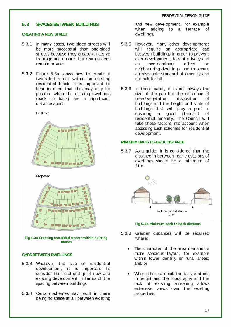
CREATING A NEW STREET
5.3.1 In many cases, two sided streets will be more successful than one-sided streets because they create an active frontage and ensure that rear gardens remain private.
5.3.2 Figure 5.3a shows how to create a two-sided street within an existing residential block. It is important to bear in mind that this may only be possible when the existing dwellings (back to back) are a significant distance apart.
Existing:
Proposed:
Fig 5.3a Creating two-sided streets within existing blocks
GAPS BETWEEN DWELLINGS
5.3.3 Whatever the size of residential development, it is important to consider the relationship of new and existing development in terms of the spacing between buildings.
5.3.4 Certain schemes may result in there being no space at all between existing
and new development, for example when adding to a terrace of dwellings.
5.3.5 However, many other developments will require an appropriate gap between buildings in order to prevent over-development, loss of privacy and an overdominant effect on neighbouring dwellings, and to secure a reasonable standard of amenity and outlook for all.
5.3.6 In these cases, it is not always the size of the gap but the existence of trees/vegetation, disposition of buildings and the height and scale of buildings that will play a part in ensuring a good standard of residential amenity. The Council will take these factors into account when assessing such schemes for residential development.
MINIMUM BACK-TO-BACK DISTANCE
5.3.7 As a guide, it is considered that the distance in between rear elevations of dwellings should be a minimum of 21m.
Back to back distance 21m
Fig 5.3b Minimum back to back distance
5.3.8 Greater distances will be required where:
• The character of the area demands a more spacious layout, for example within lower density or rural areas; and/or
• Where there are substantial variations in height and the topography and the lack of existing screening allows extensive views over the existing properties.
17

RESIDENTIAL DESIGN GUIDE
5.3.9 Reduced distances may be possible if:
• The dwelling’s main aspect and habitable windows are at oblique angles to each other;
• Fences, walls and other screening is secured by planning conditions; and/or
• The distances are in character with the area and the privacy of any existing properties would not be further reduced. For example, where some overlooking already occurs, additional windows may not materially diminish privacy.
INFILL DEVELOPMENT
5.3.10 New infill development, situated part way along streets should complement the pattern of development in the rest of the street.
5.3.11 The environment created by the new development and/or new accesses to a new backland development should make a positive contribution to enhancing the character of the street.
5.4 PASSIVE SOLAR DESIGN
5.4.1 Proposals should carefully consider the orientation of buildings since it is vital in making best use of passive solar design (PSD). PSD reduces the need for energy. It intentionally exploits solar heat gain and maximises natural daylight.
Fig 5.4a The Principle of Passive Solar Design
5.4.2 Optimum orientation is for either the front or rear elevation of a dwelling to be within 30 degrees of south. This tends to result in an east-west street pattern.
Fig. 5.4b Orientate dwelling to within 30 degrees from south
5.4.3 It is possible to move up to 30 degrees away from due south and yet have 90-95% of the maximum output of a Photovoltaic (PV) module or a solar collector. However, the common goal is to stay within 15-20 degrees of south. Obstructions such as projecting garages and porches and staggered plans on south sides should be avoided so as to prevent overshadowing.
5.4.4 A detached dwelling will use more energy than a semi-detached or terraced dwelling. Proposals for detached dwellings with small gaps of separation will be discouraged in favour of attached dwellings where this would not harm the character of the locality.
5.5 CONNECTIONS & MOVEMENT
5.5.1 “The proposed site must be connected to the existing surrounding routes and neighbourhoods creating a district that is accessible and easy to get around.” (CABE, 2005)
CONNECTING YOUR SITE TO THE SURROUNDINGS
5.5.2 Development with poor links to the surrounding area will be unacceptable. These forms of development will be more likely to encourage movement to and from it by car rather than by more sustainable modes such as walking or cycling.
5.5.3 With small sites it may not be possible to create many new connections to the surroundings. In these cases it will be important to take advantage of any boundaries of the site that are adjacent to surrounding streets.
18

RESIDENTIAL DESIGN GUIDE
Fig 5.5a Connecting a site to the surrounding streets
5.5.4 In some cases it may not be possible to make any new connections at all, for example if the development site is too small or the arrangement of surrounding development restricts the creation of new vehicular accesses. In these cases, it is important to consider whether a pedestrian only access can be created or whether this step of the design process is bypassed altogether.
5.5.5 “Proximity and easy access to good public transport and facilities is essential in reducing the number of car journeys and making a place more accessible to a variety of groups” (CABE, 2005)
MOVEMENT HIERARCHY
5.5.6 When considering new connections in and around the site, care should be taken to follow the user hierarchy as outlined in the Government advice, Manual for Streets (DCLG, 2007). This will ensure a more sustainable form of residential development:
pedestrians, however they should be considered first.
5.5.8 With regard to crime, vehicular and pedestrian routes should be designed to ensure that they are visually open, direct and well used.
STREETS
5.5.9 Straight streets are an efficient use of land and provide direct and legible routes for pedestrians. However, long straight streets should generally be avoided since they can be monotonous and lead to higher traffic speeds.
5.5.10 Buildings should front onto streets rather than footpaths. This improves activity to the front of houses, allows for on-street parking and provides ease of access for service vehicles.
CUL-DE-SACS
5.5.11 The use of cul-de-sacs is common in new housing developments, particularly for schemes of less than 10 dwellings.
5.5.12 Where cul-de-sacs are used they should be short and straight to allow good visibility from one end to the other. Cul-de-sacs which are linked to one another with footpaths are likely to be unacceptable as this is known to generate crime. If possible cul-de-sac layouts should allow for future development and not sterilise land on adjacent sites (see Fig 5.5b below).
1 Pedestrians 2 Cyclists 3 Public transport users 4 Specialist service vehicles, for
example, emergency services (particularly access for fire engines), refuse collection vehicles, etc
5 Other motor traffic Fig 5.5b Short cul-de-sac that allows for future
development
5.5.7 The hierarchy does not mean that it is always more important to provide for
5.5.13 Long and winding cul-de-sacs that create a confused arrangement of dwellings should be avoided. This
19
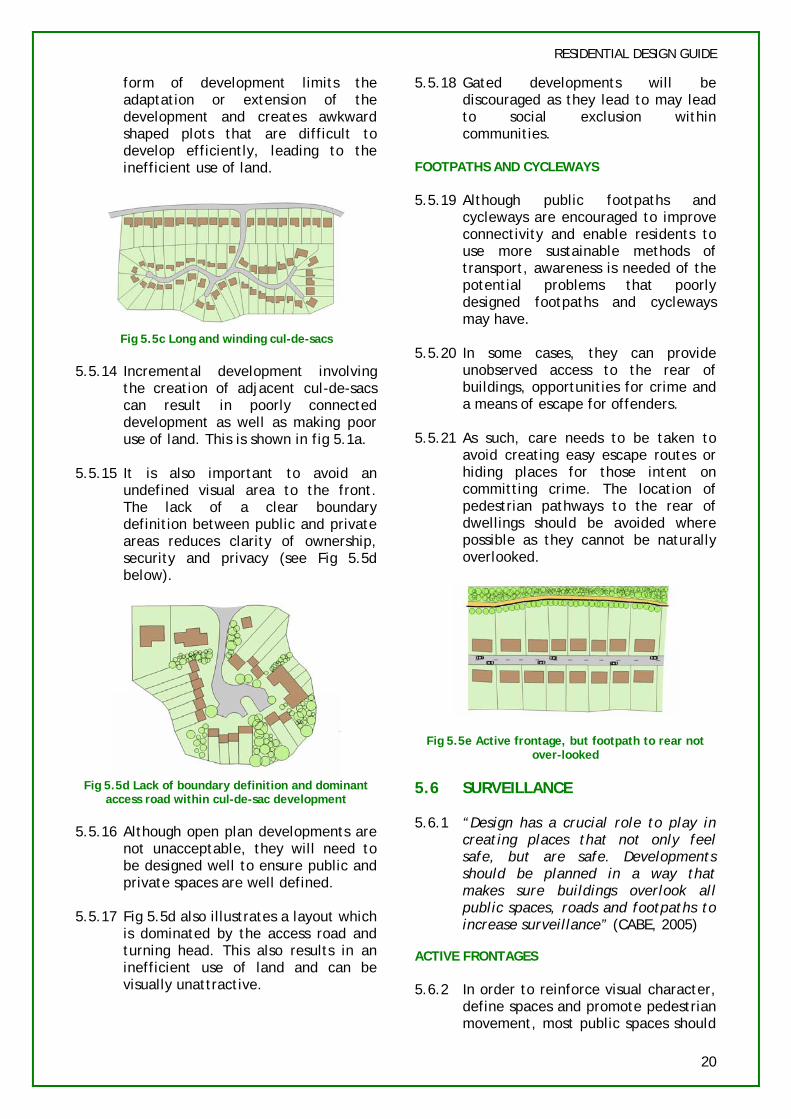
form of development limits the adaptation or extension of the development and creates awkward shaped plots that are difficult to develop efficiently, leading to the inefficient use of land.
Fig 5.5c Long and winding cul-de-sacs
5.5.14 Incremental development involving the creation of adjacent cul-de-sacs can result in poorly connected development as well as making poor use of land. This is shown in fig 5.1a.
5.5.15 It is also important to avoid an undefined visual area to the front. The lack of a clear boundary definition between public and private areas reduces clarity of ownership, security and privacy (see Fig 5.5d below).
Fig 5.5d Lack of boundary definition and dominant access road within cul-de-sac development
5.5.16 Although open plan developments are not unacceptable, they will need to be designed well to ensure public and private spaces are well defined.
5.5.17 Fig 5.5d also illustrates a layout which is dominated by the access road and turning head. This also results in an inefficient use of land and can be visually unattractive.
RESIDENTIAL DESIGN GUIDE
5.5.18 Gated developments will be discouraged as they lead to may lead to social exclusion within communities.
FOOTPATHS AND CYCLEWAYS
5.5.19 Although public footpaths and cycleways are encouraged to improve connectivity and enable residents to use more sustainable methods of transport, awareness is needed of the potential problems that poorly designed footpaths and cycleways may have.
5.5.20 In some cases, they can provide unobserved access to the rear of buildings, opportunities for crime and a means of escape for offenders.
5.5.21 As such, care needs to be taken to avoid creating easy escape routes or hiding places for those intent on committing crime. The location of pedestrian pathways to the rear of dwellings should be avoided where possible as they cannot be naturally overlooked.
Fig 5.5e Active frontage, but footpath to rear not over-looked
5.6 SURVEILLANCE
5.6.1 “Design has a crucial role to play in creating places that not only feel safe, but are safe. Developments should be planned in a way that makes sure buildings overlook all public spaces, roads and footpaths to increase surveillance” (CABE, 2005)
ACTIVE FRONTAGES
5.6.2 In order to reinforce visual character, define spaces and promote pedestrian movement, most public spaces should
20
RESIDENTIAL DESIGN GUIDE
be faced by the fronts of buildings and their entrances, not by a predominance of flank elevations or side or rear boundaries. This will contribute to security by enabling informal supervision by residents of public spaces and help integrate new schemes into an area.
5.6a Front windows overlooking parking
5.6.3 Side elevations with few or no windows facing onto the street or area of open space should be avoided.
5.5b This side elevation provides poor surveillance to this street scene and parking area
5.6.4 Where a side elevation faces an area of public space it should be designed so that the habitable or actively used rooms (such as living rooms) overlook it, particularly at the ground floor. This means that there should be a positive relationship between an elevation and the street onto which it faces.
5.7 OPEN SPACE
5.7.1 “Too often, public space is the area left once buildings have been planned, this can lead to undefined areas with no specific use.” (CABE, 2005)
5.7.2 The provision of open space within settlements is important due to its amenity and recreational value. There
is a need to protect open spaces within the district and to ensure the provision of further areas of open space in new development.
5.7.3 In terms of their design, open spaces should be focal areas in the overall development and recognisable places in their own right. They should not be left over areas in the corner of the site, or hidden away behind back fences. Buildings should front onto them to ensure a good level of surveillance.
5.7.4 The provision of public open space and landscape features must be seen as an integral part of any development. Residential development proposals should consider and take into account existing areas of Open Green Space, and the Local Plan policy governing these (L7).
PRIVATE GARDENS FOR DWELLINGS
5.7.5 Particularly where family housing is proposed, it will be important to ensure that the needs of children are taken into account and that there is good provision of recreational areas, including private gardens, play areas and informal play space. These should be well-designed, safe, secure and stimulating areas with safe pedestrian access.
5.7.6 All houses should have an enclosed private garden. The size of garden will normally be expected to be commensurate with the size of the dwelling, with larger dwellings having larger gardens. Where possible gardens should be large enough to accommodate mature trees and planting and provide private sitting out areas which are not over-looked.
5.7.7 Although sizes of gardens cannot be stipulated as every development is assessed on its own merits, applicants should consider the following needs when designing garden space for a private dwelling:
21

RESIDENTIAL DESIGN GUIDE
• Children’s play space;
• An area free from overlooking;
• Space for drying of clothes;
• An area which will receive sunlight; and
• Space for mature trees and planting.
COMMUNAL GARDEN SPACE
5.7.8 Flatted development should have access to a landscaped space and where appropriate, ground floor occupiers should have an enclosed private garden or some form of defensible space.
5.7.9 In some town centre locations with high density development, the ability to provide landscaped areas may be limited. In these cases the outside space may include a communal garden and/or balconies.
5.7.10 Any unusable spaces between car parks, roads and buildings will not be considered as part of the communal garden provision.
5.7.11 Communal gardens must be screened and secured from parking areas, public roads and footpaths and an on-going landscape maintenance programme should be adopted. They should receive some sunlight, be located away from bin stores, and be attractive spaces that residents will want to use.
Fig 5.7a Communal gardens should be attractive, light and easily accessible to residents/occupants
LARGER RESIDENTIAL SCHEMES
5.7.12 In larger schemes of residential development the Council may require additional provision of open space in accordance with policy R4 of the Local Plan. It may be necessary for a planning obligation to be entered into to secure the provision of open space together with its future management and maintenance, where necessary.
5.7.13 Very large residential development would be expected to provide both large and smaller areas of public open space that link into a network of connected spaces and routes, in order to facilitate the movement of wildlife. As such, planning for open space should also involve an assessment of potential wildlife habitats and impact on biodiversity. These considerations will be emphasised in part 7.1 of the design guide (page 30).
5.7.14 For further information on open space please refer to the Council’s Open Space, Sports and Recreational Facilities Strategy
PROVISION OF PUBLIC ART
5.7.15 The Council will encourage the provision of public art where appropriate within the design. Public art works within residential development can be used to reinforce the local identity of a place and create a legible layout.
Fig 5.6b Mosaic in Beaconsfield Old Town
5.8 DENSITY
5.8.1 The density of a development should be appropriate to its context and level of accessibility. It is important
22
to recognise that density is not an overriding factor and a high quality environment should be created by all developments irrespective of density.
5.8.2 Policy H9 states that permission will not be granted for proposals which do not make as full and effective use of land as would be possible whilst remaining consistent with all other policies in the Local Plan.
5.8.3 Low density schemes which are poorly designed will be unacceptable. On the contrary higher density schemes which are well designed will make a positive contribution to the character of the area.
5.8.4 An increased density in the right location can assist in ensuring that other housing and environmental objectives are fulfilled such as protection of the Green Belt, use of brownfield land, sustainable development and meeting housing need.
5.9 PARKING
5.9.1 Car parking should be well integrated and situated so it enhances the appearance of the street scene and should be influenced by realistic expected levels of car ownership, the importance of promoting good design and the need to use land efficiently.
5.9.2 South Bucks has relatively high levels of car ownership compared to many other authorities, and proposed parking layouts should reflect this.
5.9.3 The design of car parking should also ensure that the layout of developments is safe and does not encourage crime.
5.9.4 The design of the development should allow for access and facilities for emergency and service vehicles.
5.9.5 For further information on the Council’s parking standards, please refer to Appendix 6 of the Local Plan and the interim guidance on
RESIDENTIAL DESIGN GUIDE
residential parking standards. Both these documents can be found on the Council’s website.
5.9.6 The type of parking chosen will be influenced by the size of the residential development and its location. In many cases, a mix of the following types of parking will achieve the best results:
GARAGES
5.9.7 The most secure place to park a car is within a garage. However integral or detached garages are not always appropriate, particularly for higher density development, as they can result in a site becoming overdeveloped. In cases where there is no in-curtilage parking, parking should be provided where cars can be seen. For further information on garages please refer to section 6.6 of this guide.
ON-STREET PARKING
5.9.8 It is important that front gardens are not given over wholly or largely to parking because it will effect the visual amenities of the locality. However on street parking can bring activity to the street and have a traffic calming effect.
COMMUNAL PARKING
5.9.9 It is important that all communal car parking is sited as close as possible to the dwellings and where possible, is visible from dwellings. All developments should avoid areas of unsupervised garage court parking as this may increase the likelihood of crime. Communal parking should be landscaped so that it is not a dominant feature of the scheme.
UNDERGROUND PARKING
5.9.10 Flatted developments should investigate the possibility of underground parking provision to minimise visual impact of parking areas. However where this is proposed, security measures such as
23

SECTION CHECKLIST URBAN STRUCTURE & LAYOUT
RESIDENTIAL DESIGN GUIDE
CCTV and the provision of good lighting should be an essential requirement to reduce the risk of crime.
5.10 BICYCLE STORES
5.10.1 In addition to parking provision, design proposals should consider the need for bicycle storage provision.
5.10.2 All bicycle storage provision should be covered, secured, well lit and easily accessible to residents.
5.11 BIN STORES
5.11.1 “Good design and layout in new development can help to secure
gardens, not receive constant sunlight, be secure and covered, with easy access for residents and collection agents.
5.11.6 Bin stores should be sited in unobtrusive locations, and should be sympathetically designed to ensure that they do not adversely affect the character and amenities of the locality
5.11.7 You may also wish to contact the Council’s Recycling Officer or Contracts Manager to confirm what types of waste are collected from different areas of the district or for specific guidance not covered in the Waste Management Design Guide.
opportunities for sustainable waste management, including for kerbside collection and community recycling as well as for larger waste facilities.” (ODPM, July 2005)
5.11.2 Developments will be expected to provide sufficient space for storage facilities for waste disposal and recycling. The amount of space needed will depend on the number and size of the residential units. For specific size requirements please refer to the British Standard BS 5906:2005 on Waste Management in Buildings.
5.11.3 Recycling targets are likely to increase in the near future and the amount and types of waste that can be landfilled are decreasing. Applicants should therefore ensure that the provision is made for separate storage of all household waste materials for recycling where appropriate. Applicants should refer to the Council’s forthcoming Waste Management Design Guide.
5.11.4 In addition one should also consider the provision of composting facilities within the layout of the development.
5.11.5 Where communal bin stores are provided they should be located away from communal open space and boundaries with neighbouring
1 Does the development follow a comprehensive approach?
2 Has the spacing between new and existing development been considered within the design of the development in order to preserve residential amenity?
3 Are the roads subservient to the building layout?
4 Is the road layout clear and defined? 5 Is the site well connected to the
surroundings? 6 Are all public areas overlooked? 7 Has adequately sized and located open
space been provided for the occupiers of the development?
8 Has adequate parking been provided (in terms of quantity and location)?
9 Does the layout include space for storage of waste and recycling which is sensitively designed and sited?
24

RESIDENTIAL DESIGN GUIDE
6. BUILDING DESIGN
The guidance set out in this section will be relevant to all residential development proposals. Getting the form, scale, massing and detailed design of the proposed development right is critical, as it will have an important influence on the character of the street scene, the wider environment and the amenity of the immediate neighbours.
Additional controls apply within Conservation Areas and on sites adjacent to Listed Buildings. For further information please consult the Council’s Conservation and Design Officer.
6.1 POSITION OF BUILDING
6.1.1 When assessing the position of a building, the Council will consider the following factors:
• Whether there is an established building line;
• The distance from flank boundaries/neighbouring properties;
• The location of the site within the street, i.e. is it a corner plot or in a row of existing buildings; and
• Nature of the surrounding development and context of the application site.
BUILDING SET-BACK
6.1.2 The set back of a dwelling from the street has a significant impact on the character of the vicinity. Generally the smaller the setback the more urban the character of the area.
6.1.3 Particularly for infill development, new dwellings should closely respect the existing building line (if there is one), so that the appearance of the new building is not over-bearing to the surroundings or prominent within the street scene. A continuous building line also provides improved surveillance and enclosure of the street.
Fig 6.1 Development set in front of existing building line can appear overdominant in street scene
6.1.4 Likewise, a building should not be positioned too far away from the street. This may create a poor level of residential amenity for neighbours and result in a smaller private back garden.
6.1.5 In some circumstances a buildings position may not need to conform to the existing building line. For example, buildings on corner plots may be set closer to the road to allow for a more legible layout.
DISTANCE FROM FLANK BOUNDARY
6.1.6 It is also important to consider the relationship with the neighbouring properties. If a new building is positioned too close to the flank boundary of its plot, the development may appear cramped in the street scene or obtrusive to the neighbouring properties.
6.1.7 Policy H11 of the Local Plan states that two storey or first floor extensions must be set at least one metre from the flank boundary of the site so that the spacious character of the area is maintained. An exception to this policy applies where the development is located adjacent to an area of open land which is likely to remain permanently open. Likewise new residential development will be expected to follow this minimum limit. In some circumstances a distance of greater than 1m may be required.
6.2 BUILDING MASS AND SCALE
6.2.1 Proposed residential development should respect the scale and massing
25

RESIDENTIAL DESIGN GUIDE
of the surrounding development. 6.2.6 Whilst a proposal might adhere to Determining the appropriate scale and these technical limits, it may not massing of new development will necessarily mean that it is acceptable depend upon the following factors: in all other respects, such as
overdominace and overdevelopment • The site location; of the site. Indeed, slavish adherence
to these technical guidelines can • The physical characteristics and result in housing developments having
conditions of the site; and a significant building mass (see Fig 6.2b below).
• The scale and proportion of surrounding buildings and spaces.
the
6.2.2 It is important that the footprint of the built form, including areas of hard standing and ancillary buildings, does not over-dominate the plot or site as a whole.
Fig 6.2a Overdevelopment of plot
6.2.3 Furthermore, the massing and height of buildings should not overshadow adjacent buildings and spaces to an unacceptable degree or result in the development appearing over-bearing or overdominant to the surroundings.
6.2.4 Householder design guidance, implemented via policies EP5 and H11, advises that single storey and two storey extensions should project no more than a 60 degree or a 45 degree line (respectively) drawn from the middle of the nearest ground floor habitable window of the neighbouring property. Likewise new residential development will be expected to conform to this criteria.
6.2.5 However just because a development is set 1m from either flank boundary and does not breach a 45 or 60 degree line drawn from the relevant windows of neighbouring properties, does not guarantee the proposal to be acceptable.
Fig. 6.2b Proposed new dwelling which adheres to technical guidelines but may appear over-dominant
due to overall mass
Fig. 6.2c Proposed new dwellings with significant mass and depth can appear overbearing to
surroundings
6.2.7 In these cases the resultant overall scale and mass of the building, can appear bulky and obtrusive to neighbouring dwellings and in the locality in general.
6.2.8 These factors are important when considering the design of new residential development. Any proposal which would appear over-dominant or obtrusive within its surroundings, by virtue of its scale and massing, will not be acceptable, even if it does adhere to the technical limits outlined above.
REPLACEMENT DWELLINGS
6.2.9 The cumulative effects of demolition and replacement upon the character of the area are important within established residential areas. As such proposals for replacement dwellings will be assessed as carefully as those for new infill development.
26
RESIDENTIAL DESIGN GUIDE
6.2.10 Any replacement should have regard to the surrounding buildings in the street scene, including the established building line, frontage widths, building mass, scale and height. However any increase in the footprint of the dwelling will be considered in the context of the quality of the design.
FLATTED DEVELOPMENTS
6.2.11 Where the principle of the redevelopment of a large detached dwellinghouse with a flatted development is acceptable, the bulk, height and form of the proposed building should be consistent with the character of the area. A positive way of doing this would be to ensure the block of flats/apartments appeared as one large dwellinghouse.
6.3 BUILDING HEIGHT
6.3.1 The height of the elevations of new development should respect the height of existing development in the vicinity.
6.3.2 Consistency in the height of eaves, parapets and ridges will assist in creating a harmonious composition with adjacent development.
6.3.3 However, variations in height may be may be acceptable, depending on the location of the site. For example, taller buildings on street corners can increase legibility and provide a townscape feature.
6.3.4 Particular care must be taken when designing for sites which have an uneven topography. In these cases the Council will have regard not only to the ridge height of new development but to grounds levels within the site. Applicants are advised to ascertain this information at an early stage and show it clearly in planning application drawings, together with the effect on relationships with surrounding buildings or other features. It is not always the case that grounds levels can be approved as part of a condition.
6.4 ARCHITECTURE
6.4.1 “Good architecture is less to do with a particular style and more to do with successful co-ordination of proportions, materials, colour and detail” (CABE, 2005).
6.4.2 Much of the new housing development across the country is of a generic form of architecture. Materials are mass-produced and use details that are not distinctive to the character of the local area. This can result in “anywhere housing”.
6.4.3 This guidance does not seek to impose a particular architectural style. Urban design is concerned with achieving a structure based on the site context, within which most architectural styles can be accommodated.
6.4.4 Housing design today often involves too many elements in the one building, all with equal weighting or importance, resulting in a building with several features which compete with one another architecturally. Using a combination of architectural styles within the same building in an attempt to create character should be avoided.
6.4.5 That is not to say that dwellings can not incorporate different features within their design, however a hierarchy of forms should be developed.
6.4.6 If possible, styles of architecture should be authentic and contemporary designs will be encouraged.
6.5 ELEVATIONAL TREATMENT
6.5.1 The design and elevational treatment of a building should respect its surroundings.
6.5.2 The proposed elevation should take into account the lines and fenestration of adjoining properties. This is particularly important for
27
RESIDENTIAL DESIGN GUIDE
attached or infill development within a continuous frontage.
Fig 6.6(a) Main lines to consider when designing adjoining development
Fig 6.6(b) Main lines to consider when designing adjoining development
6.5.3 It is not necessary for new housing to mimic or replicate neighbouring properties in order to be considered acceptable. Consistency within the building line, height of windows and other features, allows the different forms of housing to harmonise and enhance the appearance of the street scene. However features that break this arrangement, such as a bay window can add diversity and ensure that the development does not appear monotonous (see fig 6.6a).
6.5.4 Windows need to be arranged to enhance the appearance of the dwelling but also to work for views and light inside the home. It is also important to consider overlooking to neighbouring properties.
6.5.5 A mixture of window/door sizes, styles, colours and materials on the same building can disrupt its appearance and too many windows can result in a building appearing overbearing or prominent.
6.5.6 On listed buildings and in Conservation Areas PVC windows, doors and rainwater goods should be avoided.
DORMER WINDOWS
6.5.7 Dormer windows should respect the size and design of the roof of the dwellinghouse. Oversized dormer windows which dominate the roof slope and appear overbearing, will be resisted. Potential for overlooking will also be assessed.
ROOF TYPE
6.5.8 The shape, size, pitch and colour of a roof can have a significant impact on the overall design of the building.
6.5.9 Traditionally, pitched roofs have been used in preference to flat roofs, particularly in residential schemes where there is a requirement to mirror existing surrounding development. However the district has seen a number of contemporary designs in which flat roofs may be required as a fundamental element of the design concept.
6.5.10 Whichever roof type is chosen, it will need to be demonstrated as to how the design respects the context of the area.
6.5.11 For traditional styles, a mixture of gable-end, semi-hipped and hipped roof styles on the same building should be avoided.
6.5.12 Crown roofs or flat-top roofs are sometimes proposed in new developments because they allow for further accommodation within the roofspace. Although not unacceptable in principle, they can result in a building appearing overbearing to neighbouring properties and the surrounding area. When assessing new developments with crown roofs, the Council will consider the overall size of the roof and whether the design is appropriate for the context of the area.
MATERIALS
6.5.13 When considering the choice of materials within new residential development, the two main points to
28

RESIDENTIAL DESIGN GUIDE
consider are appearance and sustainability.
6.5.14 The materials used in new residential development should respect and complement the existing materials used in the street, particularly if the proposal is for an infill development.
6.5.15 Careful consideration must be given to both the colour and texture of the material, in order to enhance and respond to the building characteristics of the area.
6.5.16 The materials used should also enhance the appearance of the building itself, without making the development inappropriately prominent within the street scene. For example, the use of dark tiles around the first floor can make a building appear unduly top heavy and bulky.
6.5.17 “Development plan policies should seek to minimise the need to consume new resources over the lifetime of the development by making more efficient use of reuse of existing resources.” (PPS1)
6.5.18 Where possible, building materials should be sourced locally and from renewable sources. There is detailed guidance on sustainable materials in section 8 of the design guide.
6.5.19 The use of locally sourced materials in residential areas will enhance local distinctiveness. The Council will encourage the use of the following local brick manufacturers:
- H.G Matthews - Bovingdon Bricks - Duntons
6.5.20 It will be important to consider the materials to be used as an integral part of the proposal at an early stage of the design process, rather than merely seeking to agree these at a subsequent stage. When conditioning the use of materials, the Council will expect to see a full schedule/samples
of materials and not only roof tiles and bricks.
6.6 ANCILLARY BUILDINGS WITHIN THE RESIDENTIAL CURTILAGE
6.6.1 Integral garages which are positioned within the main mass of a dwelling and detached garages to the front of dwellings can significantly detract from the visual quality of the house and reduce the amount of surveillance to the street scene.
6.6.2 If an integral or attached garage is desired then it should be made subordinate so it does not detract from the main elements of the dwelling.
6.6.3 Detached garages should remain subservient to the dwellinghouse and not appear prominent in the street scene.
6.6.4 Free standing or attached garages can contribute to enclosure and protect privacy of garden.
6.6.5 In terms of design, ancillary garages and outbuildings should avoid the use of flat roofs if the dwellinghouse has a traditional pitched roof and avoid pitching roofs in the opposite way to the main dwelling.
SECTION 6 CHECKLIST BUILDING DESIGN
1 Is the proposal in context with the surrounding area in terms of height, scale, mass and positioning on the plot?
2 Does the proposal outline the justification for the specific architecture or style of building?
3 Does the elevational treatment enhance the appearance of the building and respect the design of other buildings in the locality?
4 Do the chosen materials enhance and respond to the building characteristics of the surrounding area?
5 Are any ancillary buildings within the residential curtilage subordinate in scale to the dwelling?
29

RESIDENTIAL DESIGN GUIDE
7. NATURAL ENVIRONMENT
7.1 BIODIVERSITY & ECOLOGICAL HABITATS
7.1.1 The District has a number of sites for nature (and geological) conservation which are outlined in Local Plan policies C10 (Key Nature Conservation Sites) and C11 (Other Nature Conservation Sites). These include sites of international, national and local importance. Policies C10 and C11 also seek to protect a number of species and their habitats, even when they are found outside of designated sites.
7.1.2 Relevant legislation on biodiversity can be found within the following documents:
• Planning policy Statement (PPS) 9: Biodiversity and Geological Conservation;
• Natural Environment and Rural Communities (NERC) Act 2006;
• Countryside and Rights of Way Act 2000;
• The Conservation (Natural Habitats) Regulations 1994, as amended (The Habitats Regulations).
7.1.3 Applications to develop sites in close proximity to designated or identified for their nature conservation interest will be subject to consultation with Natural England. Accordingly applicants should always establish whether their site has such a designation or whether it has any nature conservation interest, and this should be considered as an integral part of the design.
7.1.4 Residential development often takes place in areas with established vegetation, for example on backland plots. Such areas may well contain nature conservation interests, and it will be important to ensure that proposals do not result in harm to these interests.
Fig 7.1 Backland sites can contain areas of mature vegetation which contribute to wider important
networks
7.1.5 New residential development, however, can provide opportunities to create and enhance biodiversity through, for example, planting with native species, ensuring new habitats connect to those existing.
7.1.6 Applicants should consider existing nature conservation designations, priority areas for biodiversity, protected species and specific habitats at the earliest opportunity.
For help in this area contact the Bucks & Milton Keynes Environmental Records Centre.
7.1.7 It is important that these steps should be taken at the site analysis stage, as sites need to be checked for their ecological potential. If the development site is as yet not designated or identified as having biodiversity interests, that it is not to say that there aren’t any important species or habitats within the site. These may include existing buildings, trees, hedges or other vegetation.
7.1.8 If nature conservation interests are likely to be present, an ecological survey must be carried out. Such surveys should be carried out at the time of year when species are more likely to be present on the site.
7.1.9 The outcome of an ecological survey should be used to influence the design of residential development in order to conserve, enhance and create opportunities for biodiversity.
30
7.1.10 The surveys will need to be submitted as part of the planning application and therefore consultation is needed at an early stage to avoid significant delays.
7.1.11 A number of case studies demonstrating the possibilities can be seen within the publication, Biodiversity by Design (TCPA, 2004).
7.2 TREES
7.2.1 The District contains a wealth of trees which contribute to the special character of the area, many of which lie in potential development areas. All trees on the site should have been mapped and assessed at the site analysis stage. Consideration should not be limited to those trees which currently have a Tree Preservation Order (TPO’s).
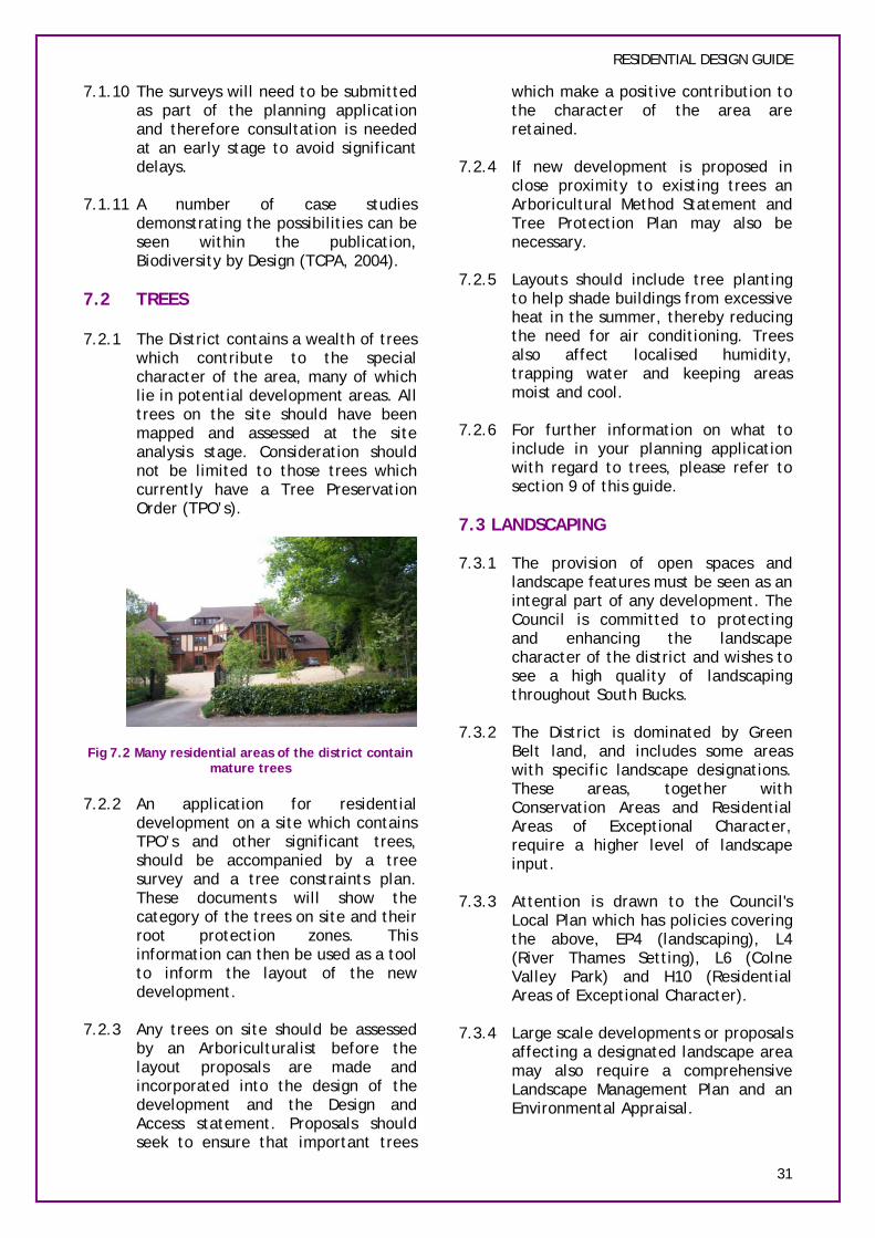
Fig 7.2 Many residential areas of the district contain mature trees
7.2.2 An application for residential development on a site which contains TPO’s and other significant trees, should be accompanied by a tree survey and a tree constraints plan. These documents will show the category of the trees on site and their root protection zones. This information can then be used as a tool to inform the layout of the new development.
7.2.3 Any trees on site should be assessed by an Arboriculturalist before the layout proposals are made and incorporated into the design of the development and the Design and Access statement. Proposals should seek to ensure that important trees
RESIDENTIAL DESIGN GUIDE
which make a positive contribution to the character of the area are retained.
7.2.4 If new development is proposed in close proximity to existing trees an Arboricultural Method Statement and Tree Protection Plan may also be necessary.
7.2.5 Layouts should include tree planting to help shade buildings from excessive heat in the summer, thereby reducing the need for air conditioning. Trees also affect localised humidity, trapping water and keeping areas moist and cool.
7.2.6 For further information on what to include in your planning application with regard to trees, please refer to section 9 of this guide.
7.3 LANDSCAPING
7.3.1 The provision of open spaces and landscape features must be seen as an integral part of any development. The Council is committed to protecting and enhancing the landscape character of the district and wishes to see a high quality of landscaping throughout South Bucks.
7.3.2 The District is dominated by Green Belt land, and includes some areas with specific landscape designations. These areas, together with Conservation Areas and Residential Areas of Exceptional Character, require a higher level of landscape input.
7.3.3 Attention is drawn to the Council's Local Plan which has policies covering the above, EP4 (landscaping), L4 (River Thames Setting), L6 (Colne Valley Park) and H10 (Residential Areas of Exceptional Character).
7.3.4 Large scale developments or proposals affecting a designated landscape area may also require a comprehensive Landscape Management Plan and an Environmental Appraisal.
31
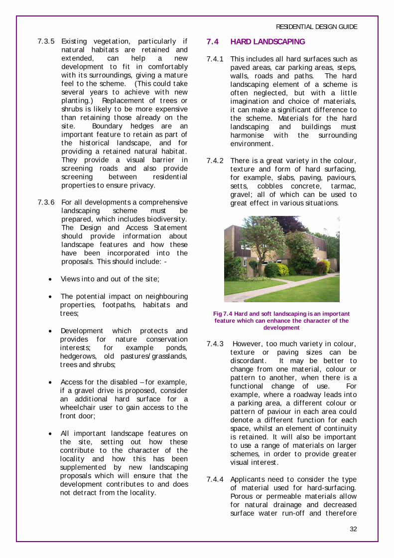
RESIDENTIAL DESIGN GUIDE
7.3.5 Existing vegetation, particularly if natural habitats are retained and extended, can help a new development to fit in comfortably with its surroundings, giving a mature feel to the scheme. (This could take several years to achieve with new planting.) Replacement of trees or shrubs is likely to be more expensive than retaining those already on the site. Boundary hedges are an important feature to retain as part of the historical landscape, and for providing a retained natural habitat. They provide a visual barrier in screening roads and also provide screening between residential properties to ensure privacy.
7.3.6 For all developments a comprehensive landscaping scheme must be prepared, which includes biodiversity. The Design and Access Statement should provide information about landscape features and how these have been incorporated into the proposals. This should include: -
• Views into and out of the site;
• The potential impact on neighbouring properties, footpaths, habitats and trees;
• Development which protects and provides for nature conservation interests; for example ponds, hedgerows, old pastures/grasslands, trees and shrubs;
• Access for the disabled – for example, if a gravel drive is proposed, consider an additional hard surface for a wheelchair user to gain access to the front door;
• All important landscape features on the site, setting out how these contribute to the character of the locality and how this has been supplemented by new landscaping proposals which will ensure that the development contributes to and does not detract from the locality.
7.4 HARD LANDSCAPING
7.4.1 This includes all hard surfaces such as paved areas, car parking areas, steps, walls, roads and paths. The hard landscaping element of a scheme is often neglected, but with a little imagination and choice of materials, it can make a significant difference to the scheme. Materials for the hard landscaping and buildings must harmonise with the surrounding environment.
7.4.2 There is a great variety in the colour, texture and form of hard surfacing, for example, slabs, paving, paviours, setts, cobbles concrete, tarmac, gravel; all of which can be used to great effect in various situations.
Fig 7.4 Hard and soft landscaping is an important feature which can enhance the character of the
development
7.4.3 However, too much variety in colour, texture or paving sizes can be discordant. It may be better to change from one material, colour or pattern to another, when there is a functional change of use. For example, where a roadway leads into a parking area, a different colour or pattern of paviour in each area could denote a different function for each space, whilst an element of continuity is retained. It will also be important to use a range of materials on larger schemes, in order to provide greater visual interest.
7.4.4 Applicants need to consider the type of material used for hard-surfacing. Porous or permeable materials allow for natural drainage and decreased surface water run-off and therefore
32

should be used in all new areas of hard-surfacing within the site. For detailed guidance on porous surfacing and how to design and construct permeable surfaces please refer to the Government document: Guidance on the permeable surfacing of front gardens (2008) which can be found at http://www.communities.gov.uk/doc uments/planningandbuilding/pdf/pavi ngfrontgardens.pdf
7.4.5 Paths must be wide enough for wheelchair access, and should have a smooth but non-slip surface.
7.4.6 More detailed guidance on designing for disabled people is available from the Council's Access Officer.
7.5 BOUNDARY TREATMENT
7.5.1 The landscape proposals need to show all proposed and existing boundary treatments, such as hedges, fences, walls and railings. Boundary treatments have a number of purposes, such as:
• defining space;
• providing security;
• creating a link between the buildings and landscape;
• providing a barrier between private and public uses; and
• influencing the microclimate depending upon the type of treatment.
RESIDENTIAL DESIGN GUIDE
function causing excessive shading over gardens and requiring eventual topping which can often appear unsightly. Beech or Hawthorn hedging forms good boundary screening and are native species of the District.
7.6 FLOODING
7.6.1 Flooding policies will be incorporated in the Local Development Framework Core strategy and Development Control Policies Documents. Until that time the following guidance should be read in conjunction with PPS25 and with the Council’s Strategic Flood Risk Assessment at http://www.southbucks.gov.uk/envir onment/planning/local_development_ framework/background_studies/2367. asp
7.6.2 It is important to ensure that development design takes flood risk into account at all stages in the planning process to:
• avoid inappropriate development in areas at risk of flooding; and
• direct development away from areas at highest risk.
7.6.3 Where new development is exceptionally necessary in such areas, it is essential to ensure the development is safe without increasing flood risk elsewhere, and where possible, reducing flood risk overall.
7.5.2 The choice of boundary treatments should be appropriate to their surroundings.
7.5.3 To add interest, colour and variety to a residential development, fencing may be replaced or supplemented by hedge planting.
7.5.4 Fast growing confers should normally be avoided: although they provide effective screening in a short space of time, they can quickly outgrow their
A site specific Flood Risk Assessment (FRA) is required to support a planning application for sites larger than 1 ha in Flood Zone 1, and all proposals for new development in Flood Zones 2 and 3 in England.
7.6.4 Flood risk is a combination of the probability of the flood occurring and the consequence of the flood on people, property and infrastructure. When determining the flood risk at a site it is important to follow a site-specific FRA. Advice on the
33
RESIDENTIAL DESIGN GUIDE
preparation of these can be found in the ‘Living Draft’ Practice Guide Companion to PPS25 at the Department of Communities and Local Government www.communities.gov.uk. Alternatively you can visit the Environment Agency site at www.environment-agency.gov.uk
SUSTAINABLE URBAN DRAINAGE (SUDS)
7.6.5 Sustainable Urban Drainage Systems (SUDS) reduce the amount of surface run-off that runs directly to rivers through storm water systems. Rapid run-off from developments with traditional drainage systems is a contributory factor in flooding incidents.
7.6.6 Developers should consider incorporating the following SUDS approaches into their proposals:-
a) Porous pavements – run-off permeates through porous pavements such as permeable concrete blocks, crushed stone, asphalt or other surfacing.
b) Swales and basins – these provide temporary storage for storm water, reduce peak flows and can be created as landscape features within a site. Swales and basins also facilitate the filtration of pollutants.
7.6.7 SUDS can also be incorporated onto building surfaces, such as ‘green’ or turf roofs, providing additional benefits to biodiversity and visual amenity.
7.6.8 SUDS can sometimes reduce the need to construct or access surface water sewers or pipe connections to distant outfalls.
SECTION CHECKLIST NATURAL ENVIRONMENT
1 Has the proposal safeguarded any nature conservation interests on the site or other nearby land?
2 Have all existing trees on site (whether TPO or not) been assessed and have important trees which contribute to the character of the site or locality been retained and incorporated into the design?
4 Have landscape features been identified/assessed/incorporated into the scheme (including biodiversity elements such as creation of habitats and connection to existing habitats, hard landscaping and boundary treatment)?
5 Has a porous materials been chosen for the hard-surfacing of the site?
6 Is a FRA necessary for the site? If so has one been carried out?
34

RESIDENTIAL DESIGN GUIDE
8. SUSTAINABLE DESIGN & CONSTRUCTION
8.1 SUSTAINABILITY
8.1.1 This section provides advice which will assist in ensuring that developments are sustainable. It will be important to ensure that design is sustainable, and essential that it does not adversely affect the amenity or character of the neighbouring properties and the locality.
8.1.2 The Government has set stringent standards of 60% carbon dioxide reduction by 2060. If this target is to be met then changes in the building industry need to happen now.
8.1.3 Sustainability should be designed into any proposals at the earliest opportunity. Sustainable design is concerned with ensuring that: -
• The construction of buildings minimises the amount of resources
THE CODE FOR SUSTAINABLE HOMES
8.1.5 The Code for Sustainable Homes came into effect in May 2008. Essentially, the Code measures the sustainability of a home against design categories rating the ‘whole home’ as a complete package. The Code can be found on the Local Government and Communities web site at www.communities.gov.uk
8.1.6 Minimum standards for Code compliance have been set out in Building Regulations. The Government will ratchet up standards over consecutive years as follows: -
Date 2010 2013 2016
Energy Carbon Improvement as compared to Part L (Building Regulations 2006)
25% 44% Zero Carbon
Equivalent energy/carbon standard in the Code
Code Level 3
Code Level 4
Code Level 6
and energy used, and waste, pollution and carbon dioxide (CO2) produced;
• The materials generated and used for construction are environmentally friendly;
• Any existing building fabric is re-used as far as possible;
• Buildings are energy efficient, reducing CO2 emissions;
• Buildings use renewable energy sources;
• Lifetime homes standards are included in design increasing the life span of a building;
8.1.4 To work out your construction carbon footprint click on the following link to the Environment Agency: http://www.environmentagency.gov.uk/business/444304/5025 08/1506471/1506565/1508048/188390 7/?lang=_e
Fig 8.1 Code for Sustainable Homes (2006) Buildings Standards
8.2 ENERGY
8.2.1 Energy use in buildings accounts for nearly half of the UK’s delivered energy consumption, and corresponding Carbon Dioxide (CO2) emissions.
8.2.2 Developments should incorporate energy reduction/saving measures in the initial design and construction of a building. These can significantly reduce the amount of energy consumed, and the running costs of a building.
8.2.3 Developers should use the following energy hierarchy in ascending order when considering design: –
35

RESIDENTIAL DESIGN GUIDE
Energy Hierarchy 1. Reduce the need for energy 2. Ensure the efficient use of required
energy 3. Include local energy generation e.g.
small scale renewables 4. Finally, any continuing use of fossil
fuel based energy must be clean and efficient
ENSURE EFFICIENT USE OF ENERGY
8.2.4 For advice about the efficient use of energy in buildings, please refer to the following websites: www.energysavingtrust.org.uk www.carbontrust.co.uk www.tvenergy.org
LOCAL ENERGY GENERATION – SMALL SCALE RENEWABLES
8.2.5 Once building energy use has been minimised, then you need to consider the source of energy used.
SOLAR WATER HEATING
8.2.6 Solar collectors or panels containing water absorb the heat of the sun. Solar collectors continue to heat water without sunlight.
8.2.7 They can be installed at low level or on the roof of a building or incorporated into the roof finish. The optimum location is facing slightly west of due south and at a tilt of 30 - 40º although a collector set anywhere between East and West and at a tilt of between 10 and 60º will perform at high levels.
PHOTOVOLTAICS (PV)
8.2.8 Solar energy can be turned into electricity via the use of PV cells. These cells, formed into panels, or more bespoke products, such as tiles, glass or sheets convert solar energy into electrical energy.
8.2.9 PV is one of the easiest renewable energy systems to install in the built environment as PV panels can be fixed
to or form an integral part of the building fabric.
SMALL-SCALE WIND ENERGY
8.2.10 There may be potential for wind energy to be captured. 1 – 1.5kW sized turbines are now being sold as attachments to buildings.
8.2.11 For maximum gain, it is essential to understand and monitor wind dynamics before installation.
GROUND SOURCE HEAT PUMPS (GSHPS)
8.2.12 GSHPs can be used to efficiently heat a building by drawing heat from the ground, concentrating it and delivering it to the building.
8.2.13 Heat pumps would be installed within a building and are particularly suitable for swimming pools and for buildings with under floor heating. GSHP’s can operate in reverse to provide cooling.
COMBINED HEAT AND POWER (CHP) AND BIOMASS UNITS
8.2.14 Biomass units provide only heat, whilst CHP units provide both heat and power. Both processes result in a significant reduction in CO2 emissions. A unit to serve an individual dwelling is about the size of a small fridge and would normally be installed internally within a garage, utility room or small outbuilding. Larger CHP or biomass units would normally serve a minimum of about 10 dwellings, and again would be installed within a building.
With all forms of renewable energy, apart from those to be installed under permitted development rights, the Council will consider siting and appearance as part of the planning application. The device should be located so as not to appear prominent or detract from the character of the building or development as a whole.
36
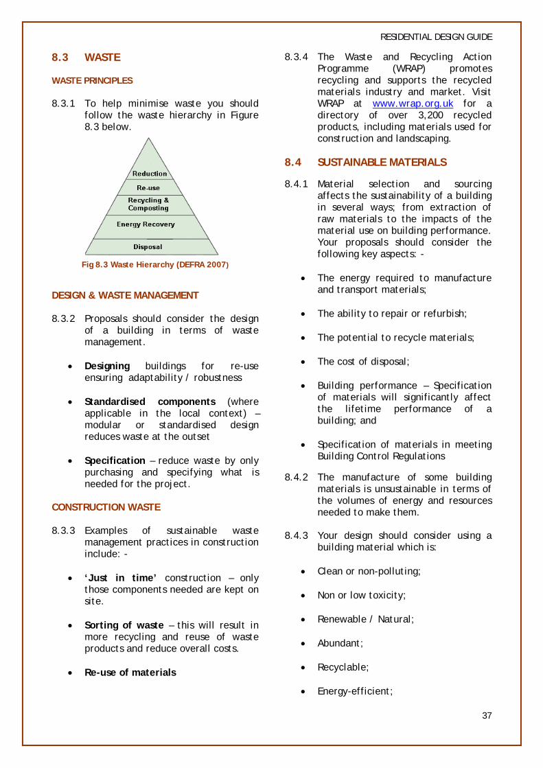
8.3 WASTE
WASTE PRINCIPLES
8.3.1 To help minimise waste you should follow the waste hierarchy in Figure 8.3 below.
Fig 8.3 Waste Hierarchy (DEFRA 2007)
DESIGN & WASTE MANAGEMENT
8.3.2 Proposals should consider the design of a building in terms of waste management.
• Designing buildings for re-use ensuring adaptability / robustness
• Standardised components (where applicable in the local context) – modular or standardised design reduces waste at the outset
• Specification – reduce waste by only purchasing and specifying what is needed for the project.
CONSTRUCTION WASTE
8.3.3 Examples of sustainable waste management practices in construction include: -
• ‘Just in time’ construction – only those components needed are kept on site.
• Sorting of waste – this will result in more recycling and reuse of waste products and reduce overall costs.
• Re-use of materials
RESIDENTIAL DESIGN GUIDE
8.3.4 The Waste and Recycling Action Programme (WRAP) promotes recycling and supports the recycled materials industry and market. Visit WRAP at www.wrap.org.uk for a directory of over 3,200 recycled products, including materials used for construction and landscaping.
8.4 SUSTAINABLE MATERIALS
8.4.1 Material selection and sourcing affects the sustainability of a building in several ways; from extraction of raw materials to the impacts of the material use on building performance. Your proposals should consider the following key aspects: -
• The energy required to manufacture and transport materials;
• The ability to repair or refurbish;
• The potential to recycle materials;
• The cost of disposal;
• Building performance – Specification of materials will significantly affect the lifetime performance of a building; and
• Specification of materials in meeting Building Control Regulations
8.4.2 The manufacture of some building materials is unsustainable in terms of the volumes of energy and resources needed to make them.
8.4.3 Your design should consider using a building material which is:
• Clean or non-polluting;
• Non or low toxicity;
• Renewable / Natural;
• Abundant;
• Recyclable;
• Energy-efficient;
37

RESIDENTIAL DESIGN GUIDE
• Locally obtained;
• Durable;
• Design efficient.
8.4.4 For further information on materials contact the Buildings Research Establishment at www.bre.co.uk
8.5 WATER
8.5.1 Average household demand for water continues to increase. You should consider implementing the following water efficiencies options to reduce water use:
RAINWATER HARVESTING TECHNIQUES
8.5.2 At its simplest, rainwater harvesting is a water butt connected to a downpipe to provide water for the garden. Systems can be as complex or as simple as the end product requires, and this depends on whether the water is for human consumption (potable water).
8.5.3 Rainwater collector systems are simple to install in new buildings and need only minimal maintenance. A tank buried underground is ideal and several can be linked together for larger installations.
WASTE WATER RECYCLING SYSTEMS
8.5.4 Greywater (water that has already been used in washbasins, showers and baths) can be recycled and used again for toilet flushing and other non-potable functions. Recycling technologies are similar to rainwater harvesting systems, but can involve filtering and disinfection.
8.5.5 Blackwater is water that has been used for toilet flushing and washing up. It is also possible to recycle this water by passing it through a blackwater recycling system – or composter. This breaks down solids to produce an end product that can be used as a fertilizer. The water is filtered and purified ready for reuse.
8.5.6 Grey and blackwater systems should be checked for functionality and certified safe by an accredited person or authority.
8.6 POLLUTION CONTROL
8.6.1 Developments can be both affected by pollution or expose existing communities to additional pollutant exposure. Pollutants which can be naturally occurring as well as resulting from historic or current land uses can be transmitted through land, air and water. This advice should be read in conjunction with Government guidance which is set out in PPS23 (Planning and Pollution Control)
8.6.2 You should:-
• Avoid using products/raw materials that have potential to release harmful chemicals into the environment;
• Avoid using or introducing equipment and machinery which is likely to produce elevated noise levels or unnecessary noise at night;
• Include the planting of trees to absorb pollutants;
• Specify materials with low toxicity which is benign during use and on disposal;
• Avoid light pollution by investing in best practice design or assessing the need for lighting in the first instance;
• Apply energy efficiencies at the highest possible standards set out in the Code for Sustainable Homes, ensuring low carbon emissions.
8.7 LIVEABILITY AND LIFETIME HOMES
8.7.1 Good design involves ensuring that housing is flexible and responsive to the changing future needs of society.
8.7.2 Your design should consider the liveability aspects of residential development to capture current and
38

RESIDENTIAL DESIGN GUIDE
future needs. Approaches to development which consider long term aspects will reduce the need for resources by increasing the lifetime value of the development.
Best practice needs to follow the requirements as laid out by the current Code for Sustainable Homes standard.
SECTION 8 CHECKLIST SUSTAINABLE DESIGN & CONSTRUCTION
1 Does the layout of the development reduce the need for energy, for example by passive solar design?
2 Does the proposal incorporate high-energy efficiency standards and any renewable energies? If so, are they sited so as not to detract from the appearance of the development?
3 Can waste materials from any existing development be re-used?
4 Does the scheme incorporate facilities for recycling and composting of waste?
5 Does the proposal include any water harvesting techniques?
6 Will the method of construction ensure minimum pollution to the surroundings?
7 Will the design and construction ensure flexibility for changing needs for future societies?
39

9. SUBMITTING A PLANNING APPLICATION
9.1 APPLICATIONS FOR HOUSEHOLDER EXTENSIONS
9.1.1 The guidance contained within this document relates to residential development of one dwelling or more, however the Council has a Householder Extensions Design Guide, copies of which can be obtained from the Council Offices or viewed on the website: www.southbucks.gov.uk/environment /planning/house_extensions_guidance /default.asp
9.1.2 The householder design guide is based on the policies in the Local Plan. If the guidance is followed, your extension is more likely to be granted planning permission, and unnecessary delays should be avoided.
9.2 PRE-APPLICATION ADVICE & FEES
9.2.1 Before submitting a planning application we suggest that you write to us with details of your proposal so we may advise you on the acceptability of your scheme. Ideally, pre-application discussions should be held at an early stage within the design process.
9.2.2 It is Council policy not to entertain amended plans duirng the application process. As such if there are any unacceptbale aspects and you do not wish to receive a refusal of planning permission the application will need to be withdrawn and re-submitted with the amendments. We can then publicise the changes and re-consult the relevant parties.
9.2.3 There is an up-front charge for advice from the Council’s Development Control team relating to all residential development of one dwellinghouse or more.
9.2.4 The cost of the advice varies depending on the seniority of the officer dealing with your query and
RESIDENTIAL DESIGN GUIDE
the length of time it would take to review the proposals and provide the response. Additional charges apply if a meeting is required.
9.2.5 For further information on pre-application fees please refer to the Council’s website.
9.3 DESIGN & ACCESS STATEMENTS
9.3.1 Design and Access statements will be required for all planning applications for residential development.
9.3.2 Design and Access Statements are written submissions that explain the design thinking behind a planning application. They should show that the applicant has thought carefully about how everyone, including the disabled, elderly and very young will be able to use the places that the applicant wants to build.
9.3.3 The aim of Design and Access Statements is to aid the provision of high quality developments, and to encourage better informed negotiation and decision-making.
9.3.4 A Design and Access Statement should:
• Explain the design principles and concepts that have informed the development, and how access issues have been dealt with;
• Ensure that design and access are not treated as entirely separate issues; each component should inform the other;
• Include a written description and justification of a planning application. Sometimes photographs, maps and drawings will also be included to illustrate the perceived benefits of a scheme further. They do not replace the need for the usual plans and drawings that are currently required;
• Avoid jargon and overly technical language;
40
RESIDENTIAL DESIGN GUIDE
• Relate specifically to the application that it accompanies; and
• Reflect the complexity of the proposal contained in the application. For example, a statement for a rear conservatory will be shorter and more concise than for a proposal to construct several new dwellings.
9.4 LISTED BUILDING & CONSERVATION AREAS
9.4.1 Design and Access Statements for Listed Building Consent applications will take largely the same format as those for standard planning applications, although in addition they should include a brief explanation of how the design has taken account of paragraph 3.5 of PPG15 (Planning and the Historic Environment), in particular:
• The historic and special architectural interest of the building;
• The particular physical features of the building that justify its designation as a listed building; and
• The building's setting.
9.4.2 A Design and Access Statement relating to a Listed Building will need to explain and justify the approach to ensuring that the proposal preserves or enhances the historic or architectural importance of the listed building.
9.5 OTHER REQUIREMENTS
9.5.1 Depending upon the scale of the development scheme and the site constraints, further technical studies or site investigations may be required.
9.5.2 Any development that involves trees, either directly or indirectly should provide arboricultural survey information as part of the planning application.
9.5.3 Other studies may include:
• Environmental Impact Assessment (EIA)
• Landscape and Visual Impact
• Ecology and proected species
• Land contamination
• Flood Risk Assessment
9.5.4 For further information on what to include within your planning application please refer to the document Validation of Planning Applications: Requirements of South Bucks District Council which can be found on the website.
9.6 COMMUNITY INVOLVEMENT
9.6.1 The Council acknowledges the importance for the community to have their say in development proposals and considers it will be most effective during pre-application stage. Prospective applicants are encouraged to consult and involve the public during pre-application stage, especially on major or controversial development proposals.
9.6.2 Early community involvement is regarded beneficial to applicants. It facilitates the application process, as the prospective applicants could understand local issues and concerns in advance. They could then be able to negotiate and build consensus with the public to avoid objections and subsequent delay during the formal application stage.
9.6.3 For further information, please refer to the Council’s Statement of Community Involvement.
41

RESIDENTIAL DESIGN GUIDE
10. GLOSSARY
ACCESSIBILITY The ability of people to move around an area and to reach places and facilities, including elderly and disabled people, those with young children and those encumbered with luggage or shopping
ACTIVE FRONTAGE The ground floor of a building or row of buildings with windows, or doors that face directly onto the street
ADAPTABILITY The capacity of buildings or spaces to respond to changing needs within society or to accommodate different uses and changes in technology
BUILDING LINE The line formed by the front of buildings along a street. The building line can be shown on a plan and may not be straight over a long distance, it could for example be stepped or indented at regular intervals
CONTEXT The setting of a development
CURTILAGE The area of land associated with a dwelling. Often called the “plot”
DENSITY The floorspace of a building or buildings or some other unit measure in relation to a given area of land. Built density is expressed as number of units per hectare for residential development
DEVELOPMENT The carrying out of building, engineering, mining or other operations in, on, over or under the land or the making of any material change in the use of any building or land
ELEVATION The façade of a building, or the drawing of a facade
ENCLOSURE The use of buildings or structures to create a sense of defined space
FENESTRATION The pattern and proportion of windows
FRONTAGE A length of building or site in contact with a road, street or public space
GABLE The triangular part of wall where it meets a pitched roof
HABITABLE ROOMS Rooms in a dwelling used as living accommodation. Bathrooms, toilets, stairwells etc. are not included.
INTENSIFICATION The redevelopment of sites at higher densities
42
RESIDENTIAL DESIGN GUIDE
LANDSCAPING The treatment of land, including soft and hard treatments such as paving or street furnishings as well as planting
LAYOUT The way buildings, routes and open spaces are placed in relation to each other
LEGIBILITY A measure of how easy it is to “read” an area and to find one’s way around
LOCAL DISTINCTIVENESS The positive features of a place and its communities which contribute to its special character and sense of place
MASS A combination of the height, bulk and scale of a building or group of buildings
NATURAL SURVEILLANCE The deterrence of nuisance and wrong-doing by the presence of passers-by or the ability of people to be seen from surrounding windows
PERIMETER BLOCK A block of continuous frontage development that defines the public realm and encloses private backs within it
PERMEABLE SURFACE Permeable surfaces work by allowing water to soak through the surface into the ground below
PUBLIC REALM Outdoor public areas that are freely accessible, including streets, open space, play areas, etc, and those contiguous private areas that can be seen, but not accessed such as front gardens
SETBACK The distance from the edge of the street to the front of the building
TOPOGRAPHY A description or representation of artificial or natural features on or of the ground
TREE PRESERVATION ORDER (TPO) A legal order used to protect trees or woodland by preventing works to trees without the consent of the local planning authority
URBAN DESIGN The art of making places. Urban design involves the design of buildings, groups of buildings, spaces and landscapes in villages, towns and cities, and the establishment of frameworks and processes which facilitate successful development
43
RESIDENTIAL DESIGN GUIDE
11. INFORMATION RESOURCE
PLANNING POLICIES:
1. Planning Policy Statement (PPS) 1: Delivering Sustainable Development (February 2005), ODPM
2. Planning Policy Statement: Planning and Climate Change – Supplement to Planning Policy Statement 1 (December 2007), DCLG
3. Planning Policy Statement (PPS) 3: Housing (November 2006), DCLG
4. Planning Policy Statement (PPS) 9: Biodiversity and Geological Conservation (August 2005), ODPM
5. Planning Policy Statement (PPS) 10: Planning for sustainable waste management (July 2005), ODPM
6. Planning Policy Statement (PPS) 12: Local Development Frameworks (June 2008), DCLG
7. Planning Policy Statement (PPS) 13: Transport (April 2001), DETR
8. Planning Policy Statement (PPS) 22: Renewable Energy (August 2004), ODPM
9. Planning Policy Statement (PPS) 23: Planning and Pollution Control (November 2004), ODPM
10. Planning Policy Statement (PPS) 25: Development and Flood Risk (December 2006), DCLG
REFERENCES & FURTHER READING:
URBAN DESIGN:
1. Building for life (2005), CABE http://www.buildingforlife.org/AssetLibrary/9350.pdf
2. Manual for streets (2007), DCLG www.communities.gov.uk/publications/planningandbuilding/manualforstreets
3. Urban Design Compendium (August 2000) Llewelyn-Davies, English Partnerships & Housing Corporation:
4. By Design: Urban Design in the Planning System: Towards Better Practice (2000), DETR & CABE
5. Urban Design Compendium 2 (September 2007), Llewelyn-Davies, English Partnerships & Housing Corporation
6. Responsive Environments (1985), Bentley, I (et al) Architectural Press
7. Better Places to Live by Design: A Companion guide to PPG3 (2001), DTLR & CABE
44

RESIDENTIAL DESIGN GUIDE
CRIME:
8. Secured by Design Principles (2004)
9. Safer Places: The Planning System and Crime Prevention (2004) ODPM
BIODIVERSITY
10. Biodiversity By Design (2004), TCPA
SUSTAINABLE CONSTRUCTION
11. The Waste and Recycling Action Programme (WRAP) www.wrap.org.uk
12. BRE Environmental Assessment Methodology (BREEAM) www.bre.org.uk
13. Code for Sustainable Homes (2006), DCLG
14. Building a Greener Future (2006), DCLG
45

Capswood, Oxford Road, Denham, Buckinghanshire UB9 4LH
Tel: 01895 837200
http://www.southbucks.gov.uk//