Reshaping of Urban Open Spaces and Waterfronts in Post ... · Reshaping of Urban Open Spaces and...
82
Reshaping of Urban Open Spaces and Waterfronts in Post-Socialist Cities The Case of Tbilisi Davit Asanidze Dissertation to obtain the degree of Master in: Urban Studies and Territorial Management Supervisor: Eng. Pedro Luis Janela Pinto Supervisor: Prof. Jorge Manuel Gonçalves Jury President: Prof. Maria Beatriz Marques Condessa Supervisor: Eng. Pedro Luis Janela Pinto Members: Prof. Maria da Graça Magalhães do Amaral Neto Lopes Saraiva Prof. Ana Isabel Loupa Ramos July 2015
-
Upload
nguyenkhanh -
Category
Documents
-
view
222 -
download
0
Transcript of Reshaping of Urban Open Spaces and Waterfronts in Post ... · Reshaping of Urban Open Spaces and...
Reshaping of Urban Open Spaces and Waterfronts
in Post-Socialist Cities
The Case of Tbilisi
Davit Asanidze
Dissertation to obtain the degree of Master in:
Urban Studies and Territorial Management
Supervisor: Eng. Pedro Luis Janela Pinto
Supervisor: Prof. Jorge Manuel Gonçalves
Jury
President: Prof. Maria Beatriz Marques Condessa
Supervisor: Eng. Pedro Luis Janela Pinto
Members: Prof. Maria da Graça Magalhães do Amaral Neto Lopes Saraiva
Prof. Ana Isabel Loupa Ramos
July 2015
i
ABSTRACT
Cities which have gone through the long period of integration in the ex-Soviet Union naturally
incorporated a set of urban, environmental economic and social principles that are now under
pressure. One of the issues that now need to be addressed is the relationship between city and
river, now subject to a very different set of written and unwritten rules from that of a few decades
back.
The early part of the 1990s was a very difficult time for Georgia. In its first few years as an
independent country political and social turmoil hampered the transition to a new social structure,
and led to severe economic constraints that lasted several years. At the turn of the XXI century
the country was able to gradually overcome stagnation. In the case of urban planning, this period
saw the introduction of new legislation which provided the foundation for a new era of urbanism
more attuned to the reality of modern European urban legislation and the new political-economic
reality.
At present, territorial planning, as a single system of state spatial planning, is highly unstructured
and has very little practical influence, with several urban planning decisions being made with little
regard for formal urban planning agencies. One of the key issues in the capital city, Tbilisi, is the
lack of social recreational zones, which is also expressed in the loss of public space along the
urban riverfront.
The dissertation explores the changes to the economic and social conditions and how this
influenced urban policies and planning standards, during the Soviet-era and in Post-Soviet
years. It provides international examples of riverfront interventions. An analysis of positive
elements, problems to avoid, and opportunities identified in those examples is used as a basis to
produce a set of recommendations that could influence positively the way riverfront interventions
and Georgian town planning are conducted.
Keywords: Urban Space, Riverfront, Urban Rehabilitation, Post-Socialist City, Tbilisi.
ii
RESUMO
As cidades da ex-União Soviética desenvolveram-se sob influência de um conjunto de princípios
urbanísticos, socio-económicos e ambientais que estão, desde a mudança de sistema político,
sujeitos a uma forte pressão de mudança. Num contexto onde diversas regras escritas, ou
práticas informais, são hoje postas em causa, um dos aspetos que requere uma nova abordagem
é a relação entre rio e cidade.
O início dos anos 90 do século passado foi um período muito conturbado para a Geórgia, Nos
primeiros anos enquanto nação independente, a instabilidade política e social foi um obstáculo
a uma transição mais suave para um novo modelo social. Esta transição foi acompanhada por
graves restrições a nível económico que se estenderam por largos anos. Na viragem para o
séc.XXI, o país foi finalmente capaz de progressivamente vencer a estagnação económica.
Durante esta fase, foi introduzida nova legislação, finalmente capaz de servir de base a uma
nova era de desenvolvimento urbanística em acordo com a realidade contemporânea na Europa
Ocidental, e mais ajustada ao novo regime socio-político.
Ainda assim, o sistema de planeamento do território está ainda muito desarticulado e
desadequado à nova realidade. A capacidade efetiva de influência do mercado imobiliário e
mecanismos de desenvolvimento urbanístico, por parte do setor público, é ainda fortemente
limitada, com várias decisões de desenvolvimento urbanístico a serem tomadas à revelia das
entidades (teoricamente) competentes. Um dos focos deste problema situa-se precisamente na
capital e maior cidade, Tbilisi, onde vastas áreas de espaço público têm vindo a ser
transformadas, com criação de zonas privadas ou concessionadas e redução das áreas
destinadas ao lazer.
A dissertação explora as mudanças das condições socio-económicas e como estas se podem
relacionar com a transição das políticas e padrões urbanísticos vigentes na era soviética para a
nova realidade pós-soviética. Através da análise de exemplos internacionais de intervenção em
espaços urbanos ribeirinhos, procede-se a uma análise dos elementos positivos, bem como
ameaças a evitar, identificadas nos diversos projetos. Pretende-se que as recomendações daí
resultantes possam servir de referência à criação de padrões de desenvolvimento urbanísticos
masi adequados à nova realidade socio-política da Geórgia e, em particular, à forma como as
margens do Rio Kura, em Tbilisi, são intervencionadas.
Palavras-chave: Espaços urbanos, Frentes ribeirinhas, Reabilitação urbana, Cidade pós-
socialista, Tbilisi.
iii
Table of Contents
ABSTRACT .................................................................................................................................... I
TABLE OF CONTENTS .............................................................................................................. IIII
FIGURE INDEX ............................................................................................................................. V
TABLE INDEX.............................................................................................................................. VI
CHAPTER 1. INTRODUCTION .................................................................................................... 1
1.1 PROBLEM STATEMENT AND AIM OF THE THESIS .................................................................. 1
1.2 METHODS ......................................................................................................................... 2
1.3 STRUCTURE OF THE WORK ................................................................................................ 3
CHAPTER 2. CONCEPT OF WATERFRONT .............................................................................. 5
2.1 THE ROLE OF RIVERFRONT ..................................................................................................... 5
2.1.1 Informal vs. Formal Riverfronts ..................................................................................... 6
2.1.2 Riverfront Intervention: A Cost or an Investment? ........................................................ 6
2.2 URBEM – EUROPEAN RESEARCH PROJECT (PORTUGAL) ........................................................ 8
CHAPTER 3. INTERNATIONAL MODEL PROGRAMMES AND CASE STUDY PROJECTS . 10
3.1 HORIZON 2020 (EUROPEAN COMMISSION) ......................................................................... 10
3.2 POLIS PROGRAMME (LISBON, PORTUGAL) ........................................................................... 12
3.3 MADRID RIO (MADRID, SPAIN) .............................................................................................. 14
3.3.1 Aim of the Intervention ................................................................................................ 14
3.3.2 Planning Process ........................................................................................................ 15
3.3.3 Result and Evolution ................................................................................................... 16
3.4 PORTLAND HARBOR DRIVE (PORTLAND, UNITED STATES) ...................................................... 17
3.4.1 Aim of the Intervention ................................................................................................ 18
3.4.2 Planning Process ........................................................................................................ 18
3.4.3 Result and Evolution ................................................................................................... 19
3.5 PARIS PLAGE (PARIS, FRANCE)............................................................................................. 20
3.5.1 Aim of the Intervention ................................................................................................ 20
3.5.2 Planning Process ........................................................................................................ 21
3.5.3 Result and Evolution ................................................................................................... 22
CHAPTER 4. URBAN PLANNING IN SOVIET AND POST-SOVIET CITIES ........................... 23
4.1 SOVIET PLANNING SYSTEM ................................................................................................... 23
4.2 TRANSFORMATION AND URBAN REALITY OF POST-SOVIET CITIES ........................................... 27
4.2.1 Riverfront Transformation in Post-Soviet cities ........................................................... 29
4.3 RENOVATION OF THE RIGHT BANK OF THE VISTULA (WARSAW, POLAND) ................................. 30
iv
4.3.1 Aim of the Intervention ................................................................................................ 30
4.3.2 Planning Process ........................................................................................................ 31
4.3.3 Result and Evolution ................................................................................................... 32
4.4 THE KRYMSKAYA EMBANKMENT (MOSCOW, RUSSIA) ............................................................. 33
4.4.1 Aim of the Intervention ................................................................................................ 33
4.4.2 Planning Process ........................................................................................................ 34
4.4.3 Result and Evolution ................................................................................................... 35
CHAPTER 5. THE CASE OF TBILISI, GEORGIA ..................................................................... 36
5.1 FUNDAMENTALS OF URBAN DEVELOPMENT OF TBILISI ............................................................ 36
5.2 SOVIET TBILISI ..................................................................................................................... 41
5.3 TBILISI IN TRANSITION ........................................................................................................... 45
5.4 RECENT CHANGES AND PROBLEMS OF TBILISI’S RIVERFRONT ................................................ 46
5.4.1 Water Quality of River Kura ........................................................................................ 48
5.5 RIKE RIVERSIDE PARK .......................................................................................................... 50
5.5.1 Aim of the Intervention ................................................................................................ 51
5.5.2 Planning Process ........................................................................................................ 51
5.5.3 Result and Evolution ................................................................................................... 52
5.6 DEDA – ENA GARDEN ........................................................................................................... 54
5.6.1 Aim of the Intervention ................................................................................................ 55
5.6.2 Planning Process ........................................................................................................ 55
5.6.3 Result and Evolution ................................................................................................... 55
5.7 TIMELINE OF TBILISI IN THE CASE STUDY AREAS .................................................................... 57
CHAPTER 6. DISCUSSION AND CONCLUSION ..................................................................... 60
6.1 DISCUSSION ......................................................................................................................... 60
6.2 CONCLUSION ....................................................................................................................... 66
REFERENCES ............................................................................................................................ 69
ADDITIONAL WEB SOURCES .................................................................................................. 75

v
Figure Index
Figure 1. “River – City – People” Framework based on the “Three worlds” of Habermas
(1984). ........................................................................................................................................... 8
Figure 2. Location of Case Study Projects. Lisbon, Madrid, Portland, Paris ...................... 10
Figure 3. Location of Park of the Nations. Lisbon, Portugal, ............................................... 12
Figure 4. Embankment of Park of the Nations. Lisbon, Portugal ......................................... 13
Figure 5. Location of Madrid Rio. Madrid, Spain, ................................................................... 14
Figure 6. Embankments of Madrid Rio Project. ..................................................................... 15
Figure 7. Tunnel and New Pedestrian Area of Madrid Rio Project. ...................................... 16
Figure 8. Dynamics of Popularity of Madrid Rio Project. ...................................................... 16
Figure 9. Location of Portland Waterfront Park. Portland, United states, ........................... 17
Figure 10. 1974 Portland Highway. .......................................................................................... 17
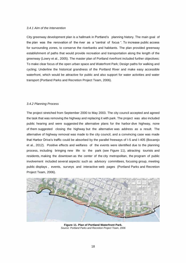
Figure 11. Plan of Portland Waterfront Park. .......................................................................... 18
Figure 12. Portland Waterfront Park. ....................................................................................... 19
Figure 13. Location of Paris Plage Project. Paris, France, ................................................... 20
Figure 14. Graphic Visualization of Paris expressway. ......................................................... 21
Figure 15. Realized Paris-Plage. .............................................................................................. 22
Figure 16. Dynamics of Popularity of Paris Plage Project. ................................................. 22
Figure 17. Location of Case Study Projects. Warsaw, Moscow ........................................... 23
Figure 18. Propagandist Magazine - “The USSR in Construction”, 1932. ........................... 24
Figure 19. Picture Slogan: “Let’s mobilize our efforts to fulfill Stalin’s plan on
reconstruction of Moscow. The plan signed by Stalin cannot be unfulfilled”. ................... 25
Figure 20. Model of Group of “microrayons” Gldani, Tbilisi, Georgia. ............................... 28
Figure 21. Location of Vistula Renovation Project. Warsaw, Poland .................................. 30
Figure 22. Embankment of the Vistula River. Warsaw, Poland. ........................................... 31
Figure 23. Renovation of the Vistula River. Warsaw, Poland. .............................................. 32
Figure 24. Location of the Krymskaya Embankment Project. Moscow, Russia ................. 33
Figure 25. Reshaping of Krymskaya Embankment. Moscow, Russia. ............................... 34
Figure 26. Promenades of Krymskaya Embankment. Moscow, Russia. ............................. 35
Figure 27. Dynamics of Popularity of Krymskaya Embankment Project. ........................... 35
Figure 28. Location of Case Study Projects. Tbilisi, Georgia ............................................... 36
Figure 29. 1800 Plan of Tbilisi, Georgia .................................................................................. 37
Figure 30.1920 Mills in Old Tbilisi, Georgia. ........................................................................... 38
Figure 31. 1802 Plan of Tbilisi, Georgia ................................................................................. 38
Figure 32. 1844 Plan of Tbilisi, Georgia .................................................................................. 39
Figure 33. 1800-1904 Tbilisi Plans Comparison .................................................................... 40
Figure 34. Baratashvili Bridge, Soviet Time. Tbilisi, Georgia ............................................... 42
Figure 35. River Kura Embankments, Soviet Time. Tbilisi, Georgia .................................... 42
vi
Figure 36. 1924 Plan of Ortachala Gardens. 1970 photo of this territory. Tbilisi, Georgia.43
Figure 37. Historic- Cultural Map of Tbilisi, Georgia ............................................................. 47
Figure 38. 1800-2007 Combined Maps of Road Structure ..................................................... 47
Figure 39. Location of Rike Riverside Park. Tbilisi, Georgia ................................................ 50
Figure 40. Territory of Rike before Sovietization. Tbilisi, Georgia. ...................................... 50
Figure 41. Rike Riverside Park. Tbilisi, Georgia. .................................................................... 51
Figure 42. Promenade of Rike Riverside Park. Tbilisi, Georgia. .......................................... 52
Figure 43. New Bridge of and Theatre in Rike Park. Tbilisi, Georgia ................................... 53
Figure 44. Bridge of Peace, Rike Park. Tbilisi, Georgia......................................................... 53
Figure 45. Location of Deda-Ena Garden. Tbilisi, Georgia ................................................... 54
Figure 46. Comparison of Changes between Soviet Time and Nowadays. Tbilisi. Georgia
..................................................................................................................................................... 54
Figure 47. Construction Process and Finished Public Service Hall. Tbilisi, Georgia ........ 55
Figure 48. Comparison of 2010 and 2012 Changes near Deda-Ena Garden. Tbilisi,
Georgia ....................................................................................................................................... 56
Figure 49. New Parking Lot Front of the River Kura. Tbilisi, Georgia .................................. 56
Figure 50. 1887-1924 Plans of Tbilisi. Georgia ....................................................................... 57
Figure 51. 2006-2010-2011 Changes in Case Study Areas. Tbilisi, Georgia. ...................... 58
Figure 52. 2012-2013-2014 Changes in Case Study Areas. Tbilisi, Georgia ....................... 59
Figure 53. Location of All Case Study Projects. .................................................................... 60
Figure 54: 2006 Map of Tbilisi. Georgia .................................................................................. 67
Table Index
Table 1. Typical characteristics of River Kura ...................................................................... 48
Table 2. Detailed Info of Projects in Madrid, Portland, Paris ................................................ 63
Table 3. Detailed Info of Projects in Warsaw and Moscow ................................................... 64
Table 4. Detailed Info of Projects in Tbilisi ............................................................................. 65
1
CHAPTER 1. INTRODUCTION
1.1 Problem Statement and Aim of the Thesis
Unmanageable growth of post-socialist city, expiration of the term of the last general plan, and
ignorance of historical traditions of city planning resulted in an abnormal and complex problem of
interplay between Tbilisi and River Kura1. The river misplaced its architectural-planning
significance, which is more apparent nowadays.
Interrelation between Tbilisi city and the River Kura constitutes complex and complicated urban
problem. Kura, as an essential active element of the landscape, used to influence city’s planning
character. Moreover, throughout times, the River has become as one of the integral component
of Tbilisi face.
In Tbilisi, since the late 1930’s during sovietization, decline has become the predominant
character of the relationship between urban centers and the water. Fast urban, demographic and
economic growth alongside extensive land reclamation and the channelizing of the Kura River
have progressively changed the nature of the waterfront. Currently, there are highways at the
both banks of river. Time by time these barriers have become the main reason that city has
problems with less public access and open space connections to the riverfront. Cities are growing
at the same time also increasing urban planning problems. The city has undergone severe
transformations to its urban landscape, losing much of its original character and becomes not
friendly with citizens. Also increasing demand of society related with access to river, open public
and leisure spaces. At the present time for Tbilisi this case is really actual and problematic. In the
world many develop cities have equally faced similar challenges.
In Georgia, day-to-day urban development practice fails to address different requirements of
riverside areas, with environmental and social benefits benefits being frequently side-lined. This
lack of an adequate balancing of conflicting land-uses may be attributed to a recent and still not
fully developed culture of contemporary urban planning. Therefore looking to this issue through
the lens of international experience, introducing foreign principles and methodology of planning
would doubtless support development of the city and resolution of town planning problems.
Developed countries have experienced several instances where attempts were made to
approximate river with the city and its inhabitants. Riverside spaces have been reorganized and
transformed into recreational and leisure parks. Grounded on consistent and pre-planned urban
policy of the city. These areas now attract more and more urban dwellers and tourists. Besides,
this process largely contributes to the shaping up the overall image of the city.
1 Kura- The name Kura is related to the name of Cyrus the Great, emperor of Persia, The Georgian
name of Kura is Mt'k'vari
2
The banks along the urban stretch of the river can, and should definitely be utilized for advancing
ecology in the city. Those areas should be reopened and brought closer to the various functions
of city centre, in order to elevate the number of social spaces and upgrade the role of the river
Kura riverside and its surrounding in Tbilisi make it possible to use its track for forming and further
expanding the city.
The research is targeted to studying and analyzing methods of planning and design of interface
zones between urban rivers and surrounding plots of land and means of connecting river stream
front space with other urban spaces. Establishment of recreational systems in profit of population
should consist of the following set of zones: river stream, waterfront and open space.
The main objective of thesis is to explore river and waterfront space designs as a sub-area of
open space and makes it subject of this particular study. The background is the contemporary
urban landscape of promptly developing metropolitan areas and large cities. Various set of rules,
regulations or policy mechanisms play important role in affecting environment and also in
determining public pedestrian zones and biking tracks. Only smart planning will enable creation
of spacious structure of urban river oriented open zone, which will fully meet people’s recreational
needs. One of the specific objectives of this dissertation is to question the City of Tbilisi project in
light of its attitude towards the waterfront greening programs, from an urban design and planning
perspective.
1.2 Methods
This research resorted to the following methods: literature review, collection of thematic
publications, observation and analysis of urban policies and programs, and the interpretation of
inquiry method Google Trends.
Literature review was based on the gathering of information from different topics, such as urban
history, land-use planning, waterfront redevelopment, or post-socialist urban transformation. A
major document source was the National Parliamentary Library of Georgia, which includes the
archival plans of Tbilisi, before and after sovietization. Books and articles related with the case of
Tbilisi are mostly in Georgian and I have translated them by myself where appropriate. Moreover,
important materials were obtained from online libraries and scientific journals, regarding riverfront
development, urban design, International planning and architectural reviews and from the other
thematic publications.
The method of observation helped to understand data collection through a comparison with the
present state of certain locations with older maps, historic imagery and photography. This
comparison produced a clear image of the evolution of certain locations that underlines the main
3
changes produced through interventions of those areas. Comparing historic documents, the
evolution of certain locations, and the timelines in the implementation of urban policies and
programs, allowed for an integration of information necessary to the interpretation, evaluation,
and criticism of the different urban interventions and development patterns under analysis.
Inquiry method Google trends is a public web source, based on Google search, which produces
as an output how often a certain term is looked for in relation to entered in the total amount of
search queries in various regions of the world. It was used in identifying patterns of public
awareness/interest regarding different case study related to the waterfront space design and
interventions.
Case study method serves as a kind of strategy for probing into the different aspects of riverfront
intervention and the transformation of land-uses and public spaces therein. The different case
study subjects were selected based on its relevance to the Tbilisi main case study areas, but also
as a transept of different solutions, based on the diverse scales and scopes of the interventions.
This allowed the identification of differences in the implemented urban design projects and the
analysis of existing practices, related to the planning and functional aspects of the reshaping of
waterfront zones and recreational areas. Applying these methods will result in shaping different
viewpoints on how to enhance the planning process and design quality, namely by foster
accessibility with river and enhancing the allocation of different land-uses and public spaces in
future waterfront interventions.
1.3 Structure of the Work
The following sections are structured as to enable understanding of main points and the role of
open urban spaces designs and reforming of riverfronts.
Second chapter deals with the review of literature on transformation, restoration and research
methods of the project related to the urban rivers and waterfront parks. Literature review provides
proper stage for further developing remaining chapters.
The third chapter describes urban programs and projects, which had already been implemented
through Western Europe and United States. This section also covers review of ideas and
techniques available in the watershed management, objectives and planning, designation of
present urban riverside restoration. Text also focuses on positive aspects of such projects, namely
how the urban waterfront and well-being of population has been improved as per realization of
projects.

4
Chapter four relays examples from soviet cities urban planning process, in particular development
of planning in socialist age and its main problematic aspects. The section also touches upon the
issue of alterations and revitalization of river embankment areas in former soviet cities.
Fifth chapter provides description of urban fundamentals in Tbilisi, difficult socialist transition
period and post-socialist conditions, it also demonstrates critical viewpoint in relation to the
interference by authority and misleading planning process of the riverfront parks.
Lastly, the final Sixth Chapter summarizes entire research and finds conclusive points for
development of urban open spaces and for reforming of Tbilisi riverfront.
5
CHAPTER 2. CONCEPT OF WATERFRONT
Cities are often rediscovering their rivers which have been generally destroyed, neglected and
separated from urban form, far away from relocated industrial facilities and usually blocked by the
highways and walls. The main focus is the transformation of industrial and derelict land by rivers
into new public areas that possibly may affect negatively on development of urban revitalization
and intense new commercial, recreational, residential and tourist activities (Kashef, 2008).
These days it’s hard to find the modern city that has river without open public space areas.
Where citizens can relax from city noise after tiring and busy day. It also plays an important role
for the city image. As the image is one of the main aspects for attracting people and for investment
and tourism.
2.1 The Role of Riverfront
According to Harvey (1989): “Vast land use changes occur during times of difficult socio-spatial
reorganization, all the economic, political, social and cultural changes of a globalized world have
their connection to urban area”. Changes like these, are frequently driven by globalization and
urbanization. Reorganizations also have influence on water, air, energy resources and,
particularly, on people (Baschak & Brown , 1995). And the demands of outdoor recreations are
growing gradually. The recreation areas become the ultimate resource for human leisure activity.
Rivers and riverfront areas are one of the most important parts of the urban open space and play
important roles in affording urban resilience and health. This is true even where the rivers have
been modified in urban areas, and instead of them have been built canals dams and artificial
levees (Junker, 2008). Therefore it’s also urgent to study the urban rivers and waterfronts in
purpose of becoming livable city and for the citizen’s well-being.
Riverfronts play an important role in the process of development of cities. Number of cities are
connected by them, by foundation and contributed to their further growth (Rigby & Breen, 1996).
Authorities of the city would like to renew their urban waterfront zones and to strengthen the land
along the river. As a matter of fact the planners of the project have to keep balance between
variety of public and private objectives. They also have to be managed so as to resolve conflict
and use the area in a rational way. Sensible planning is generally used to develop large area in
an integrated way. It is necessary in order for the waterfront to be most functional and useful of
the city (Weickmann, 2006).
6
2.1.1 Informal vs. Formal Riverfronts
People start building the towns in simple ways as they still lived in huts of the emerging world.
There is the master plan that made the town more modern, streets are laid squares and blocks
on the buildings are placed according to the planners’ sense of order. This contrast requires a lot
of time for research. That causes another contrast: between formality and informality. Whilst
“natural” city tends to informality, on the other hand the planners would like to make decisions to
their conscious show. Most of such kind of regularities in which the planners purpose to show is
just human mind have been at work, but some goal of self-conscious irregularity is visually
attractive (Broadbent, 1990). The regional development pattern, natural and cultural history, flood
control and public access must be all considered in planning for riverfront revival. The following
principles ought to be integrated into the master plans and must be implemented through the
engineering standards and building zones, for planning the sites and designs. Renovating urban
riverfront causes restoration of existing river system. New investments to a city can be drawn by
environmentally sensitive redevelopment of riverfronts including parks and trails, commercial
buildings and cultural attraction (Otto et al.,2005).
In words of Kevin Lynch (1960): “environmental images are the result of two way process between
the environment and its observer [p.6] “. Environment offers relations and variety, and the
observer with great adaptability and according to his own purposes selects and endows the
meaning what he sees, on the other hand image has limits and brightens the way of the
city, although the image may be the same it can be seen and described variously from
different observers. The image might be analyzed into three components: meaning, structure and
identity. It’s very important to abstract these components for the analyses, whether it is
remembered they will be appeared together in reality. The first thing that workable image
requires is identification of an object that implies to differ from other things, its recognition as a
divisible creature.
2.1.2 Riverfront Intervention: A Cost or an Investment?
Characterizing the expenditure of public funds for redeveloping riverfront is also an issue of
particular concern. If we treat such expenses as an investment, then it is more likely that financial
gains be expected, which will override initial investment fees. If we assume that this is
consumption, costs for this process would serve of purchasing something valuable that may not
be designed for bringing financial profits. The test for public consumption is whether the good or
service is deemed valuable enough to merit the public expenditure. Value is actually set by states
and leaders. For projects considered as public consumption, any future financial gain amount to
a price reduction, not an investment profit. Overall, the main distinctive point between public
7
investment and public consumption is whether the project was deliberately targeted on fund rising
from the very initial phase or was intended to serve economic development (Brown, 2012).
Generally, majority of disagreements among private owners and the society is a result of not
applying Public properly in a real practice. When brokers are properly trained in the private and
public needs, they will clearly explain to the future purchaser that the private property concerned
lays at the end of waterline. Which borders public domain and that potentially public trust rights
may be upgraded to the mean high waterline as well (Jackson, 2006). Whilst it’s not so easy to
evaluate the real state of future riverfront area development and related employment impacts
incumbent to it (Faye & Nelson, 2013).
The main goal of the urban renewal is to develop the specific areas of the city that are
underdeveloped. The renewal consist of the further rules: first it allows tax increment for gaining
finances and with the money to finance improvement projects. Second it allows for special
powers to buy the sites for their development or redevelopment whether that is necessary or
desired. And the third it allows for the special flexibility in working with different parties in order
to complete the project. Municipality is allowed to use urban renewal. In the case of United States,
the main purpose of the municipality should be to establish an urban renewal agency and to adapt
an urban renewal plan. The renewal agencies are generally created by state law but as a rule are
“activated” by the government. The agencies are independent legal structures, but in mostly they
are ruled from governing body. In order to undertake urban renewal project with the tax
increment financing, project should be authorized by an urban renewal plan. One of the most
common types of the project is infrastructure development that includes streets and utilities. The
parks, plazas and pedestrian facilities are also funded by the urban revitalization project. The
main targets of urban revitalization projects are making areas more pleasing and ready for private
funding (Tashman & Johnson, 2000).
8
2.2 URBEM – European Research Project (Portugal)
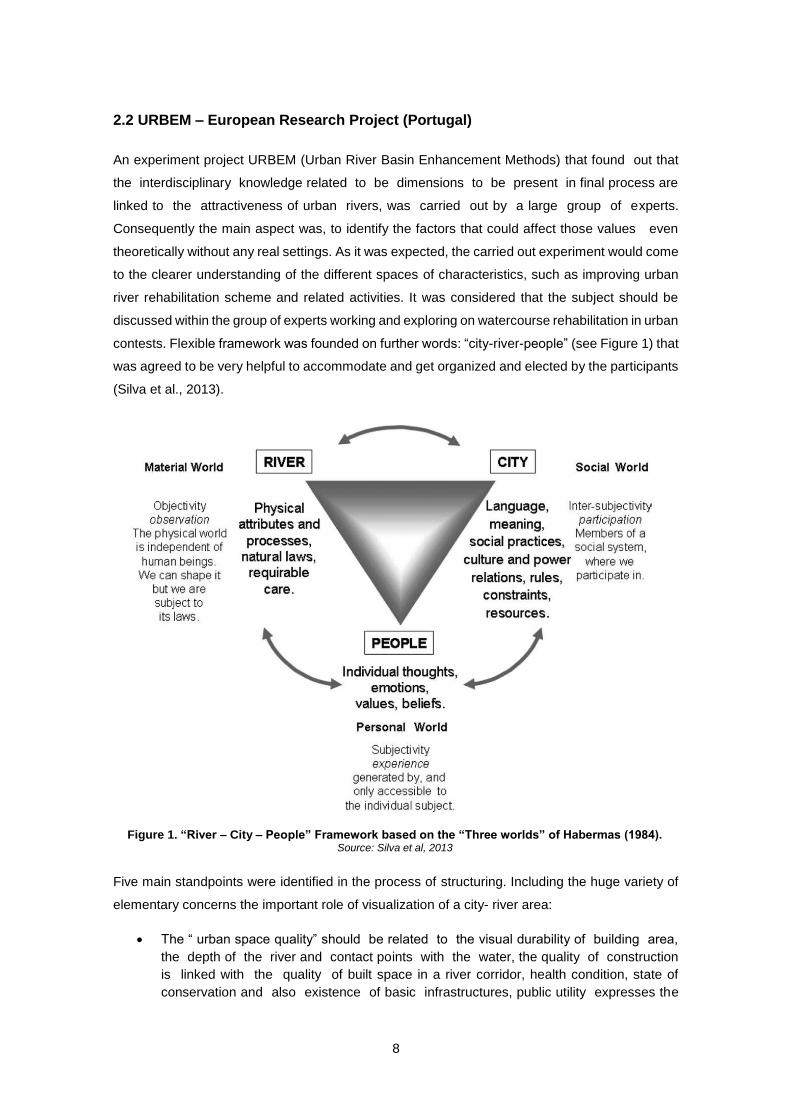
An experiment project URBEM (Urban River Basin Enhancement Methods) that found out that
the interdisciplinary knowledge related to be dimensions to be present in final process are
linked to the attractiveness of urban rivers, was carried out by a large group of experts.
Consequently the main aspect was, to identify the factors that could affect those values even
theoretically without any real settings. As it was expected, the carried out experiment would come
to the clearer understanding of the different spaces of characteristics, such as improving urban
river rehabilitation scheme and related activities. It was considered that the subject should be
discussed within the group of experts working and exploring on watercourse rehabilitation in urban
contests. Flexible framework was founded on further words: “city-river-people” (see Figure 1) that
was agreed to be very helpful to accommodate and get organized and elected by the participants
(Silva et al., 2013).
Five main standpoints were identified in the process of structuring. Including the huge variety of
elementary concerns the important role of visualization of a city- river area:
The “ urban space quality” should be related to the visual durability of building area,
the depth of the river and contact points with the water, the quality of construction
is linked with the quality of built space in a river corridor, health condition, state of
conservation and also existence of basic infrastructures, public utility expresses the
Figure 1. “River – City – People” Framework based on the “Three worlds” of Habermas (1984). Source: Silva et al, 2013
9
balance between public open areas that is given to the riverfronts and private open
spaces. That could reveal the accessibility to aesthetic values;
The “cultural heritage” architectural and historical monuments should have the great
influence on the attractiveness and aesthetic view of the river and city zones;
It is said that human “activities on the riverfront” has made a huge influence on the
final factors as well intense human contact with the river increases the interaction
between the people and the river;
“Accessibility” is an one of the most important factor to get people involve and enjoy
the process of value of the urban waterfront is the feeling of accessibility . bridges
are the most common way to cross the water on many urban areas. There are two
main functions that include linking and contacting points (Manning, 1997). Walking and
biking are the soft modes of transportation which promote closer contact with the
water and landscape;
“Pollution” of water is the problem that causes ecological and biological catastrophes
and damages the quality of people’s life .pollution, that is often caused by human
involvement influences the attractiveness of areas. and should be considered by their
physical result such as color or littering of water.
A river and its urban context should be addressed as a public space and considered as an open
area. For understanding “public perception” of a city and river landscape it must be identified
cognitions, behaviors, and feelings of its users and emphases the meaning of the project
that bank on physical element in the this field. This approach was adopted in the framework
of URBEM project and applied to five urban rivers in Portugal, one in England and three in
Slovenia, as well in two more Portuguese cities within RiProCity project. The research project
indicates that visual charm and interconnection get absolutely different emotions between
participants of expert team (Silva et al., 2013).
10
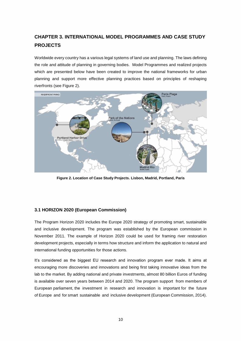
CHAPTER 3. INTERNATIONAL MODEL PROGRAMMES AND CASE STUDY
PROJECTS
Worldwide every country has a various legal systems of land use and planning. The laws defining
the role and attitude of planning in governing bodies. Model Programmes and realized projects
which are presented below have been created to improve the national frameworks for urban
planning and support more effective planning practices based on principles of reshaping
riverfronts (see Figure 2).
3.1 HORIZON 2020 (European Commission)
The Program Horizon 2020 includes the Europe 2020 strategy of promoting smart, sustainable
and inclusive development. The program was established by the European commission in
November 2011. The example of Horizon 2020 could be used for framing river restoration
development projects, especially in terms how structure and inform the application to natural and
international funding opportunities for those actions.
It’s considered as the biggest EU research and innovation program ever made. It aims at
encouraging more discoveries and innovations and being first taking innovative ideas from the
lab to the market. By adding national and private investments, almost 80 billion Euros of funding
is available over seven years between 2014 and 2020. The program support from members of
European parliament, the investment in research and innovation is important for the future
of Europe and for smart sustainable and inclusive development (European Commission, 2014).
Figure 2. Location of Case Study Projects. Lisbon, Madrid, Portland, Paris
11
Above mentioned program has gathered the scientists and industry within Europe and from
all over the world to work out the decision of vast array of challenges. The innovations
helped to protect the environment and improved the live and got European industry more
competitive and more sustainable worldwide programme Horizon 2020 gives an opportunity for
all researchers and participants to join for standard research projects, a consortium of at least
three legal entities. The obligation of each intertie is to be created in EU member state or
associated country. A Number of associated countries have established by agreement
between the EU and individual governments, where in Horizon 2020 legal entities could
participate on an equal footing to the EU member states. Coordination and support actions
funding includes the coordination and networking of research innovation projects policies and
programs.
There is only one funding rate for the all beneficiaries and all activities in research grant in Horizon
2020. 100% of illegible cost is covered by the EU funding for all researches and innovation
activities. 70% of eligible cost is generally covered by the funding for innovation actions, but there
is also possibility of increasing to 100% for non-profitable organizations. Indirect eligible cost
(e.g. and infrastructure costs, and office supplies) are reimbursed with a 25 % flat rate of the direct
eligible costs. Horizon 2020 plans to develop closer synergies that includes the national and
regional programs, to encourage private investment including research and innovations and
use Europe’s recourses to tackle the challenges (European Commission, 2014).
12
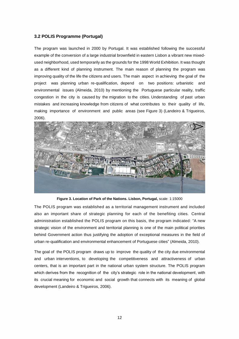
3.2 POLIS Programme (Portugal)
The program was launched in 2000 by Portugal. It was established following the successful
example of the conversion of a large industrial brownfield in eastern Lisbon a vibrant new mixed-
used neighborhood, used temporarily as the grounds for the 1998 World Exhibition. It was thought
as a different kind of planning instrument. The main reason of planning the program was
improving quality of the life the citizens and users. The main aspect in achieving the goal of the
project was planning urban re-qualification, depend on two positions: urbanistic and
environmental issues (Almeida, 2010) by mentioning the Portuguese particular reality, traffic
congestion in the city is caused by the migration to the cities. Understanding of past urban
mistakes and increasing knowledge from citizens of what contributes to their quality of life,
making importance of environment and public areas (see Figure 3) (Landeiro & Trigueiros,
2006).
The POLIS program was established as a territorial management instrument and included
also an important share of strategic planning for each of the benefiting cities. Central
administration established the POLIS program on this basis, the program indicated : “A new
strategic vision of the environment and territorial planning is one of the main political priorities
behind Government action thus justifying the adoption of exceptional measures in the field of
urban re-qualification and environmental enhancement of Portuguese cities” (Almeida, 2010).
The goal of the POLIS program draws up to improve the quality of the city due environmental
and urban interventions, to developing the competitiveness and attractiveness of urban
centers, that is an important part in the national urban system structure. The POLIS program
which derives from the recognition of the city’s strategic role in the national development, with
its crucial meaning for economic and social growth that connects with its meaning of global
development (Landeiro & Trigueiros, 2006).
Figure 3. Location of Park of the Nations. Lisbon, Portugal, scale: 1:15000
:
13
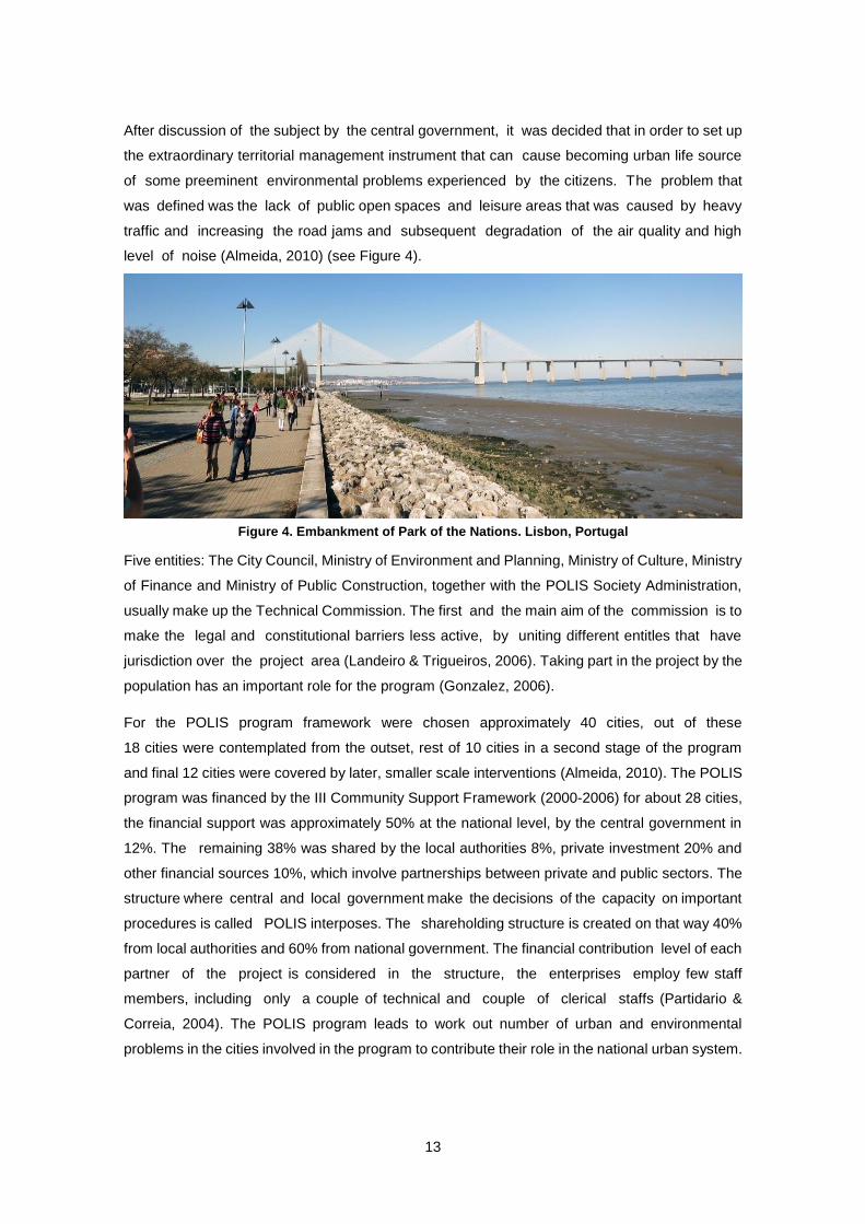
After discussion of the subject by the central government, it was decided that in order to set up
the extraordinary territorial management instrument that can cause becoming urban life source
of some preeminent environmental problems experienced by the citizens. The problem that
was defined was the lack of public open spaces and leisure areas that was caused by heavy
traffic and increasing the road jams and subsequent degradation of the air quality and high
level of noise (Almeida, 2010) (see Figure 4).
Five entities: The City Council, Ministry of Environment and Planning, Ministry of Culture, Ministry
of Finance and Ministry of Public Construction, together with the POLIS Society Administration,
usually make up the Technical Commission. The first and the main aim of the commission is to
make the legal and constitutional barriers less active, by uniting different entitles that have
jurisdiction over the project area (Landeiro & Trigueiros, 2006). Taking part in the project by the
population has an important role for the program (Gonzalez, 2006).
For the POLIS program framework were chosen approximately 40 cities, out of these
18 cities were contemplated from the outset, rest of 10 cities in a second stage of the program
and final 12 cities were covered by later, smaller scale interventions (Almeida, 2010). The POLIS
program was financed by the III Community Support Framework (2000-2006) for about 28 cities,
the financial support was approximately 50% at the national level, by the central government in
12%. The remaining 38% was shared by the local authorities 8%, private investment 20% and
other financial sources 10%, which involve partnerships between private and public sectors. The
structure where central and local government make the decisions of the capacity on important
procedures is called POLIS interposes. The shareholding structure is created on that way 40%
from local authorities and 60% from national government. The financial contribution level of each
partner of the project is considered in the structure, the enterprises employ few staff
members, including only a couple of technical and couple of clerical staffs (Partidario &
Correia, 2004). The POLIS program leads to work out number of urban and environmental
problems in the cities involved in the program to contribute their role in the national urban system.
Figure 4. Embankment of Park of the Nations. Lisbon, Portugal
14
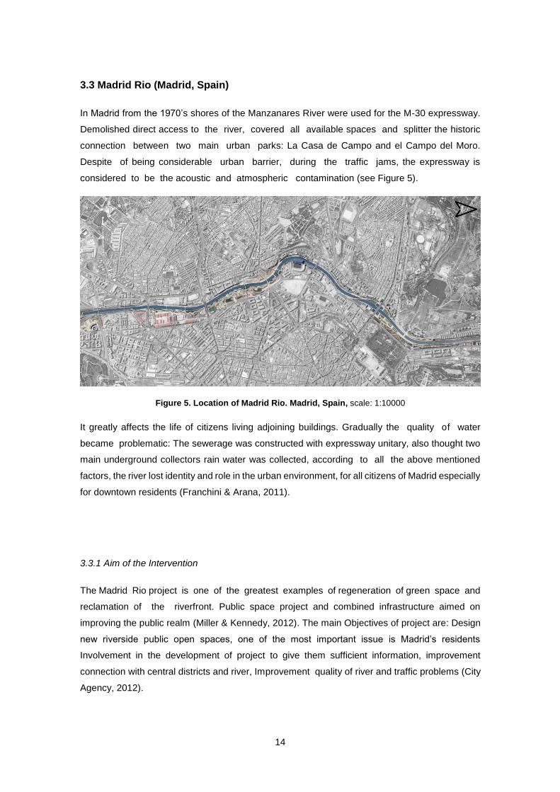
3.3 Madrid Rio (Madrid, Spain)
In Madrid from the 1970’s shores of the Manzanares River were used for the M-30 expressway.
Demolished direct access to the river, covered all available spaces and splitter the historic
connection between two main urban parks: La Casa de Campo and el Campo del Moro.
Despite of being considerable urban barrier, during the traffic jams, the expressway is
considered to be the acoustic and atmospheric contamination (see Figure 5).
It greatly affects the life of citizens living adjoining buildings. Gradually the quality of water
became problematic: The sewerage was constructed with expressway unitary, also thought two
main underground collectors rain water was collected, according to all the above mentioned
factors, the river lost identity and role in the urban environment, for all citizens of Madrid especially
for downtown residents (Franchini & Arana, 2011).
3.3.1 Aim of the Intervention
The Madrid Rio project is one of the greatest examples of regeneration of green space and
reclamation of the riverfront. Public space project and combined infrastructure aimed on
improving the public realm (Miller & Kennedy, 2012). The main Objectives of project are: Design
new riverside public open spaces, one of the most important issue is Madrid’s residents
Involvement in the development of project to give them sufficient information, improvement
connection with central districts and river, Improvement quality of river and traffic problems (City
Agency, 2012).
Figure 5. Location of Madrid Rio. Madrid, Spain, scale: 1:10000
15
3.3.2 Planning Process
The city council started working about Madrid Calle 30 projects in 2004, “involving reform and
enlargement of belt highway and to construct the 18 km dimension tunnels, collectors, hydraulic
installations and underground parking spaces, the area is known as a river zone. The Plan
involved the burying of 6 km of road and the liberation of 50 has for new green areas [p.4]” (see
Figure 6) (Franchini & Arana, 2011).
A plan to reclaim the Manzanares River was launched in June 2008, by the Department of Urban
Planning of the Madrid City Council, in order to restore the surrounding natural area for citizens
and visitors (City Agency, 2012).
The 3+30 concept based competition was also considered that 120 hectare site was designed
in order to create new walking and public zone alongside of Manzanares river and attractive large
park. The project also involves rebuilding urban assemble, that had been severed by the
motorway near the palace in Madrid (Dobrick, 2010). International architectural competition was
held for to create a master plan of Madrid Rio project. The winner of this competition became
Dutch Architectural firm West8 within collaboration three Spanish architectural studios. The aim
of the proposal was to create 30 smaller scale projects to be constructed in stages along the
Madrid Rio corridor (Corkery & Hernando, 2012). Albeit, the opposition groups suspected that the
Special Plan does not contemplate participative mechanism of control management (Franchini &
Arana, 2011).
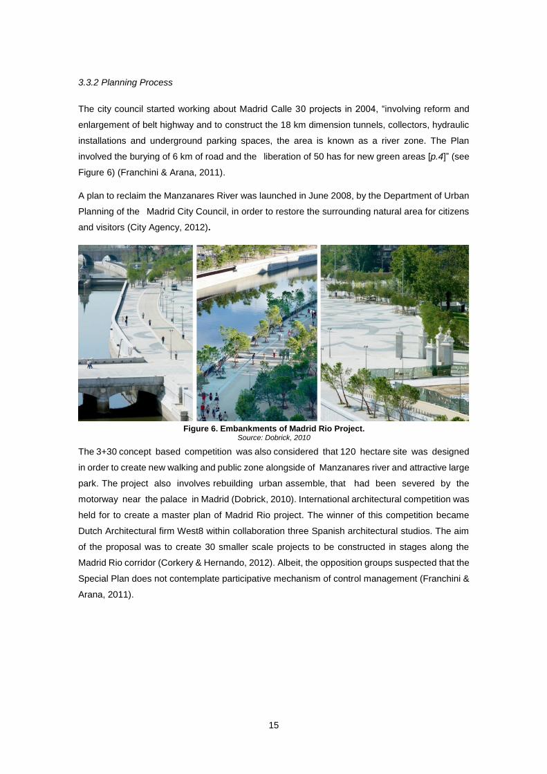
Figure 6. Embankments of Madrid Rio Project. Source: Dobrick, 2010
16
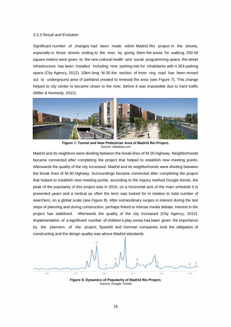
3.3.3 Result and Evolution
Significant number of changes had been made within Madrid Rio project in the streets,
especially in those streets ending to the river, by giving them the areas for walking. 250 00
square meters were given to the new cultural health and social programming space, the street
infrastructure has been installed including nine parking lots for inhabitants with 4.303 parking
space (City Agency, 2012). 10km long M-30 the section of inner ring road has been moved
out to underground area of parkland created to renewal the area (see Figure 7). This change
helped to city center to became closer to the river, before it was impossible due to hard traffic
(Miller & Kennedy, 2012).
Madrid and its neighbors were dividing between the break lines of M-30 highway. Neighborhoods
became connected after completing the project that helped to establish new meeting points.
Afterwards the quality of the city increased. Madrid and its neighborhoods were dividing between
the break lines of M-30 highway. Surroundings became connected after completing the project
that helped to establish new meeting points, according to the inquiry method Google trends, the
peak of the popularity of this project was in 2010, on a horizontal axis of the main schedule it is
presented years and a vertical as often the term was looked for in relation to total number of
searchers, on a global scale (see Figure 8). After extraordinary surges in interest during the last
steps of planning and during construction, perhaps linked to intense media debate, interest in the
project has stabilized. Afterwards the quality of the city increased (City Agency, 2012).
Implementation of a significant number of children’s play zones has been given the importance
by the planners of the project. Spanish and German companies took the obligation of
constructing and the design quality was above Madrid standards.
Figure 7. Tunnel and New Pedestrian Area of Madrid Rio Project. Source: Idealista.com
Figure 8. Dynamics of Popularity of Madrid Rio Project. Source: Google Trends
17
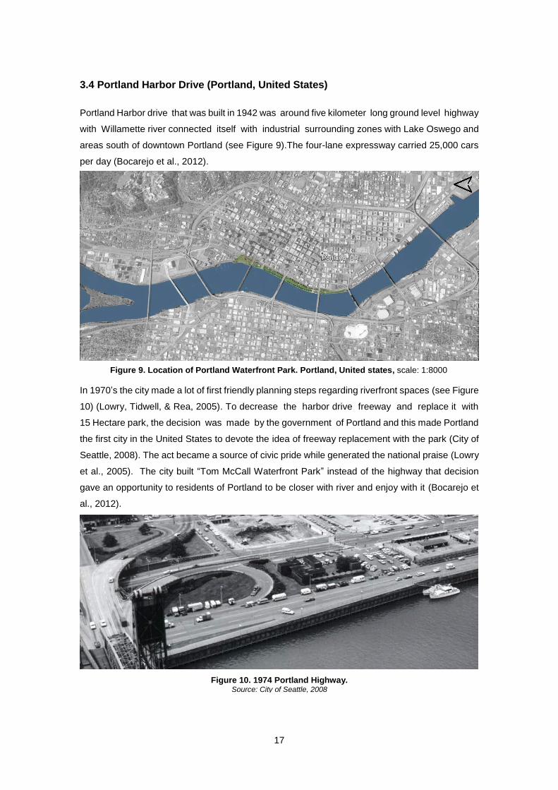
3.4 Portland Harbor Drive (Portland, United States)
Portland Harbor drive that was built in 1942 was around five kilometer long ground level highway
with Willamette river connected itself with industrial surrounding zones with Lake Oswego and
areas south of downtown Portland (see Figure 9).The four-lane expressway carried 25,000 cars
per day (Bocarejo et al., 2012).
In 1970’s the city made a lot of first friendly planning steps regarding riverfront spaces (see Figure
10) (Lowry, Tidwell, & Rea, 2005). To decrease the harbor drive freeway and replace it with
15 Hectare park, the decision was made by the government of Portland and this made Portland
the first city in the United States to devote the idea of freeway replacement with the park (City of
Seattle, 2008). The act became a source of civic pride while generated the national praise (Lowry
et al., 2005). The city built “Tom McCall Waterfront Park” instead of the highway that decision
gave an opportunity to residents of Portland to be closer with river and enjoy with it (Bocarejo et
al., 2012).
Figure 9. Location of Portland Waterfront Park. Portland, United states, scale: 1:8000
Figure 10. 1974 Portland Highway. Source: City of Seattle, 2008
18
3.4.1 Aim of the Intervention
City greenway development plan is a hallmark in Portland’s planning history. The main goal of
the plan was the renovation of the river as a “central of focus “. To increase public access
for surrounding zones, to conserve the riverbanks and habitants. The plan provided greenway
establishment of paths that would provide recreation and transportation along the length of the
greenway (Lowry et al., 2005). The master plan of Portland riverfront included further objectives:
To make clear focus of the open urban space and Waterfront Park; Design paths for walking and
cycling; Underline the historical grandness of the Portland River and make easy accessible
waterfront, which would be attractive for public and also support for water activities and water
transport (Portland Parks and Recretion Project Team, 2006).
3.4.2 Planning Process
The project stretched from September 2000 to May 2003. The city council accepted and agreed
the task that was removing the highway and replacing it with park. The project was also included
public hearing and were suggested the alternative plans for the harbor dive highway, none
of them suggested closing the highway but the alternative was address as a result. The
alternative of highway removal was made to the city council, and a convincing case was made
that Harbor Drive’s traffic could be absorbed by the parallel freeways of I-5 and I-405 (Bocarejo
et al., 2012). Positive effects and welfares of the events were identified due to the planning
process, including bringing new life to the park (see Figure 11), attracting tourists and
residents, making the downtown as the center of the city metropolitan, the program of public
involvement included several aspects: such as advisory committees, focusing group, meeting
public displays , events, surveys and interactive web pages (Portland Parks and Recretion
Project Team, 2006).
Figure 11. Plan of Portland Waterfront Park. Source: Portland Parks and Recretion Project Team, 2006
19
3.4.3 Result and Evolution
After removal of the expressway was possible to build the new recreation area near the river
Willamette, that give opportunity citizens and visitors of Portland to be closer with riverfront, the
project helped the city to established the downtown urban revitalization zone (Bocarejo et al.,
2012). The result of removal expressway had the minimal negative effects from traffic jams, in
Portland.
In order to operate more effectively traffic and to use better a street grid, all streets in the
downtown were transformed to one-way direction and traffic lights were marked in order that cars
to travel in the downtown without stopping (City of Seattle, 2008). Replacement of expressway
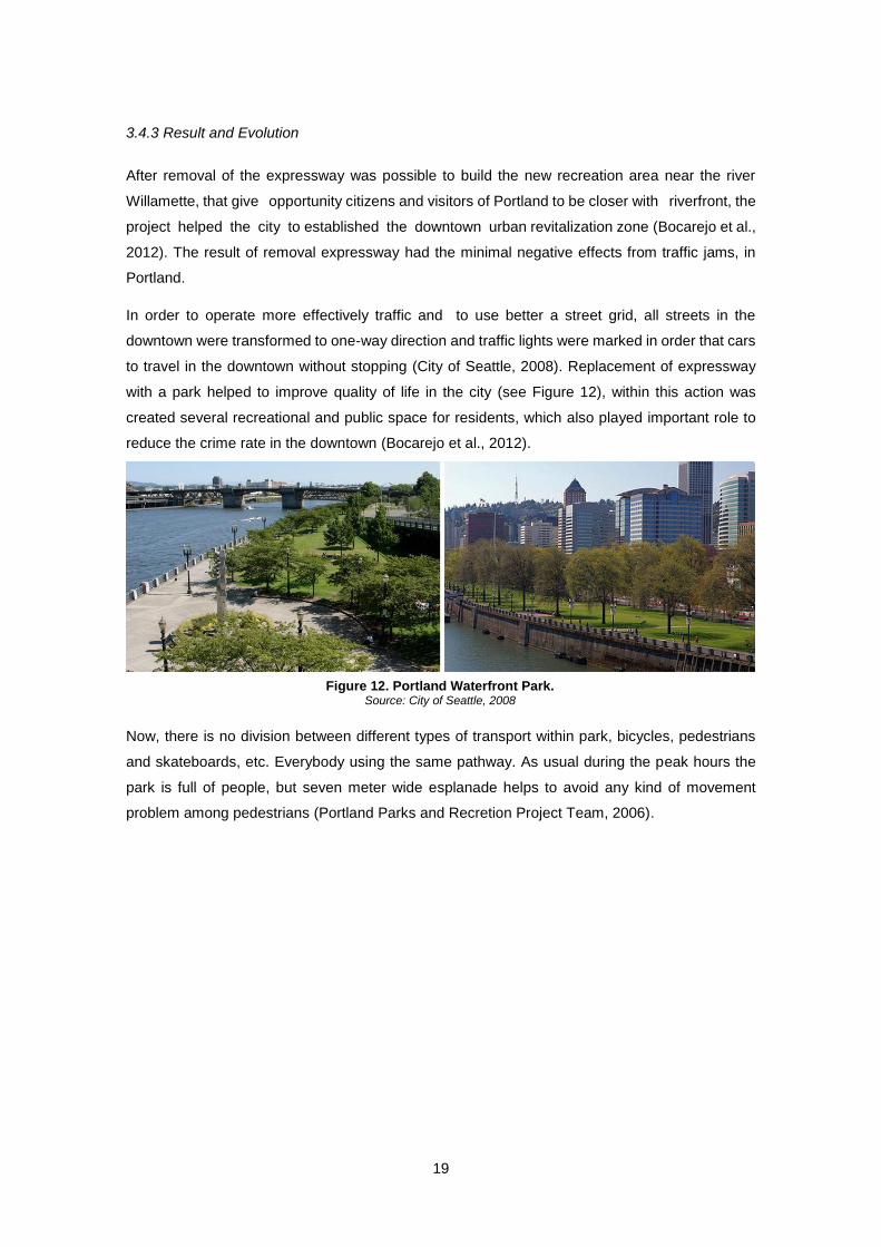
with a park helped to improve quality of life in the city (see Figure 12), within this action was
created several recreational and public space for residents, which also played important role to
reduce the crime rate in the downtown (Bocarejo et al., 2012).
Now, there is no division between different types of transport within park, bicycles, pedestrians
and skateboards, etc. Everybody using the same pathway. As usual during the peak hours the
park is full of people, but seven meter wide esplanade helps to avoid any kind of movement
problem among pedestrians (Portland Parks and Recretion Project Team, 2006).
Figure 12. Portland Waterfront Park. Source: City of Seattle, 2008
20
3.5 Paris Plage (Paris, France)
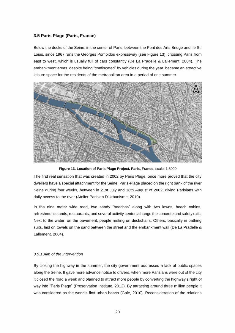
Below the docks of the Seine, in the center of Paris, between the Pont des Arts Bridge and Ile St.
Louis, since 1967 runs the Georges Pompidou expressway (see Figure 13), crossing Paris from
east to west, which is usually full of cars constantly (De La Pradelle & Lallement, 2004). The
embankment areas, despite being “confiscated” by vehicles during the year, became an attractive
leisure space for the residents of the metropolitan area in a period of one summer.
The first real sensation that was created in 2002 by Paris Plage, once more proved that the city
dwellers have a special attachment for the Seine. Paris-Plage placed on the right bank of the river
Seine during four weeks, between in 21st July and 18th August of 2002, giving Parisians with
daily access to the river (Atelier Parisien D'Urbanisme, 2010).
In the nine meter wide road, two sandy “beaches” along with two lawns, beach cabins,
refreshment stands, restaurants, and several activity centers change the concrete and safety rails.
Next to the water, on the pavement, people resting on deckchairs. Others, basically in bathing
suits, laid on towels on the sand between the street and the embankment wall (De La Pradelle &
Lallement, 2004).
3.5.1 Aim of the Intervention
By closing the highway in the summer, the city government addressed a lack of public spaces
along the Seine. It gave more advance notice to drivers, when more Parisians were out of the city
it closed the road a week and planned to attract more people by converting the highway’s right of
way into “Paris Plage” (Preservation Institute, 2012). By attracting around three million people it
was considered as the world’s first urban beach (Gale, 2010). Reconsideration of the relations
Figure 13. Location of Paris Plage Project. Paris, France, scale: 1:3000
21
with the river Seine, itself means to imagine metropolis of future (Atelier Parisien D'Urbanisme,
2010).
Given this successful character of policy, the summer closure of the Pompidou Expressway Plage
has become a regular yearly event and the municipality of city began to discuss the option of
complete closure of the expressway (Preservation Institute, 2012).
In the new projects proposed by the city government, there are various steps for further
development of the areas: Rethinking of the right bank traffic, give more free space for public
zone and to make essay access with the river. Everybody will have easy access to installation for
activities (Mairie De Paris, 2010).
3.5.2 Planning Process
Paris Plage was considered as a political act. New socialist Mayor and his public team worked
out to fulfill the plan that actually contributed greatly to increase his popularity and helped launch
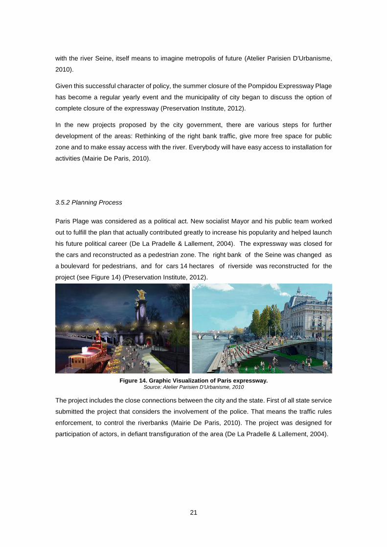
his future political career (De La Pradelle & Lallement, 2004). The expressway was closed for
the cars and reconstructed as a pedestrian zone. The right bank of the Seine was changed as
a boulevard for pedestrians, and for cars 14 hectares of riverside was reconstructed for the
project (see Figure 14) (Preservation Institute, 2012).
Figure 14. Graphic Visualization of Paris expressway. Source: Atelier Parisien D'Urbanisme, 2010
The project includes the close connections between the city and the state. First of all state service
submitted the project that considers the involvement of the police. That means the traffic rules
enforcement, to control the riverbanks (Mairie De Paris, 2010). The project was designed for
participation of actors, in defiant transfiguration of the area (De La Pradelle & Lallement, 2004).
22
3.5.3 Result and Evolution
The visitors activity was the result of Paris Plage, it would be a mere zone if the visitors were
not so active. A lot of people visited the bank of Seine, (there was no limit to the number of
visitor) the place became the perfect area Parisians meeting, for roller skaters, women and
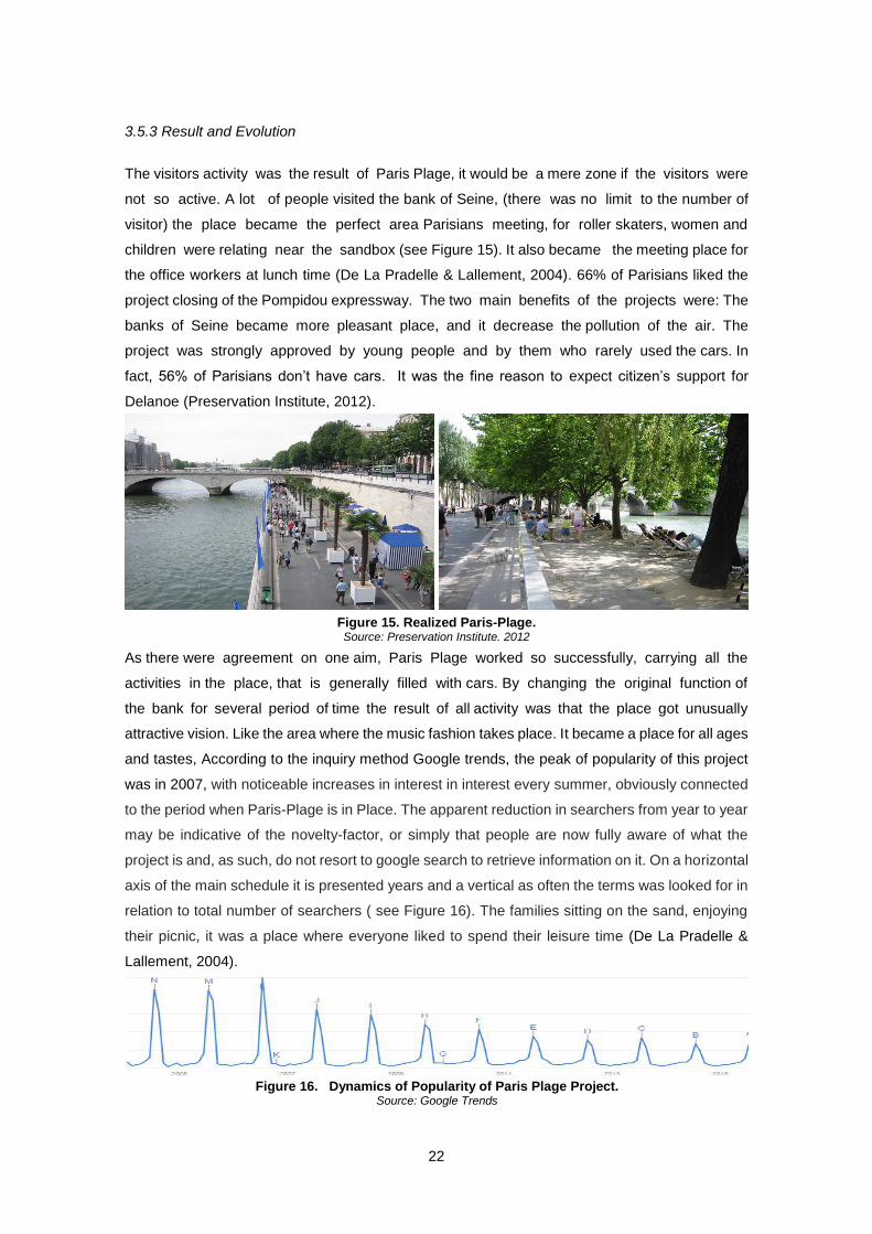
children were relating near the sandbox (see Figure 15). It also became the meeting place for
the office workers at lunch time (De La Pradelle & Lallement, 2004). 66% of Parisians liked the
project closing of the Pompidou expressway. The two main benefits of the projects were: The
banks of Seine became more pleasant place, and it decrease the pollution of the air. The
project was strongly approved by young people and by them who rarely used the cars. In
fact, 56% of Parisians don’t have cars. It was the fine reason to expect citizen’s support for
Delanoe (Preservation Institute, 2012).
As there were agreement on one aim, Paris Plage worked so successfully, carrying all the
activities in the place, that is generally filled with cars. By changing the original function of
the bank for several period of time the result of all activity was that the place got unusually
attractive vision. Like the area where the music fashion takes place. It became a place for all ages
and tastes, According to the inquiry method Google trends, the peak of popularity of this project
was in 2007, with noticeable increases in interest in interest every summer, obviously connected
to the period when Paris-Plage is in Place. The apparent reduction in searchers from year to year
may be indicative of the novelty-factor, or simply that people are now fully aware of what the
project is and, as such, do not resort to google search to retrieve information on it. On a horizontal
axis of the main schedule it is presented years and a vertical as often the terms was looked for in
relation to total number of searchers ( see Figure 16). The families sitting on the sand, enjoying
their picnic, it was a place where everyone liked to spend their leisure time (De La Pradelle &
Lallement, 2004).
Figure 15. Realized Paris-Plage. Source: Preservation Institute, 2012
Figure 16. Dynamics of Popularity of Paris Plage Project. Source: Google Trends
23
CHAPTER 4. URBAN PLANNING IN SOVIET AND POST-SOVIET CITIES
This chapter covers the issue of soviet urban planning impacts. State resources were largely
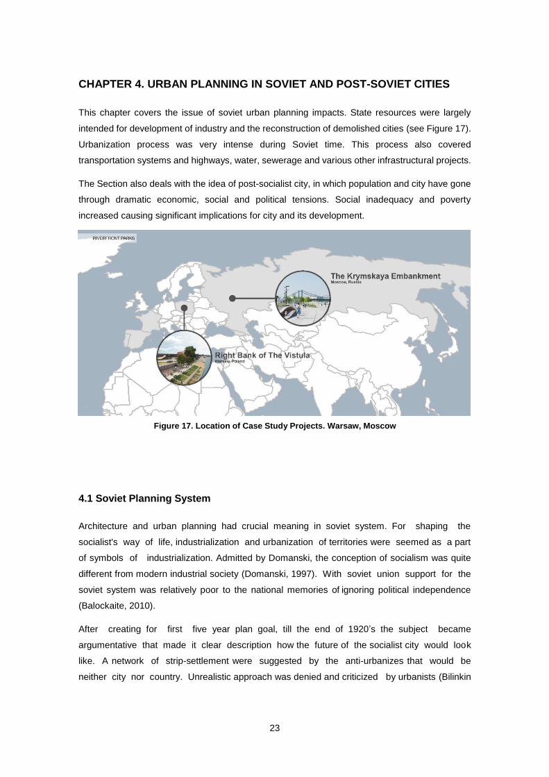
intended for development of industry and the reconstruction of demolished cities (see Figure 17).
Urbanization process was very intense during Soviet time. This process also covered
transportation systems and highways, water, sewerage and various other infrastructural projects.
The Section also deals with the idea of post-socialist city, in which population and city have gone
through dramatic economic, social and political tensions. Social inadequacy and poverty
increased causing significant implications for city and its development.
4.1 Soviet Planning System
Architecture and urban planning had crucial meaning in soviet system. For shaping the
socialist's way of life, industrialization and urbanization of territories were seemed as a part
of symbols of industrialization. Admitted by Domanski, the conception of socialism was quite
different from modern industrial society (Domanski, 1997). With soviet union support for the
soviet system was relatively poor to the national memories of ignoring political independence
(Balockaite, 2010).
After creating for first five year plan goal, till the end of 1920’s the subject became
argumentative that made it clear description how the future of the socialist city would look
like. A network of strip-settlement were suggested by the anti-urbanizes that would be
neither city nor country. Unrealistic approach was denied and criticized by urbanists (Bilinkin
Figure 17. Location of Case Study Projects. Warsaw, Moscow
24
& Ryabyshin, 1985). Despite the vagueness of socialist dream, the cities considered to be
spacious with the state ownership of land. Greenery and open space, was enough for all citizens.
One of the main factor and goal of the soviet urban planning structure was also development of
infrastructure. These were not concerns exclusive to Soviet Union, but were rather concerns
shared across the European architectural Avant-garde that had been dealing with these matters
throughout Europe in the 1920’s (Cinis et al., 2008).
There was an intensive debate between soviet urban planners and architects after the revolution
in 1917 regarding their vivid arguments and experiments (Kopp, 1970). Benefits of Soviet urban
planning also had some practical results, until Stalin’s leadership full industrialization and
state led collectivization were trying hard by its success (Service, 1997).
The role of urban and regional planners was highly increased with special needs and
consequences of economic development. New towns and cities were ordered by new industrial
regions. In order to accommodate growth of collectivization, it became necessary to
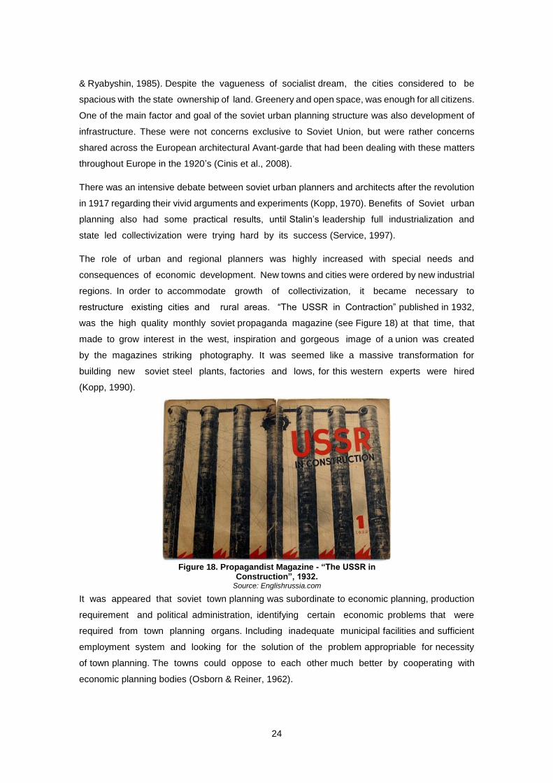
restructure existing cities and rural areas. “The USSR in Contraction” published in 1932,
was the high quality monthly soviet propaganda magazine (see Figure 18) at that time, that
made to grow interest in the west, inspiration and gorgeous image of a union was created
by the magazines striking photography. It was seemed like a massive transformation for
building new soviet steel plants, factories and lows, for this western experts were hired
(Kopp, 1990).
It was appeared that soviet town planning was subordinate to economic planning, production
requirement and political administration, identifying certain economic problems that were
required from town planning organs. Including inadequate municipal facilities and sufficient
employment system and looking for the solution of the problem appropriable for necessity
of town planning. The towns could oppose to each other much better by cooperating with
economic planning bodies (Osborn & Reiner, 1962).
Figure 18. Propagandist Magazine - “The USSR in Construction”, 1932.
Source: Englishrussia.com
25
It was often found in soviet planners writing that it was ”complex organism” and comprehensive
plan is required for modern town, but in fact most of the municipalities were without master
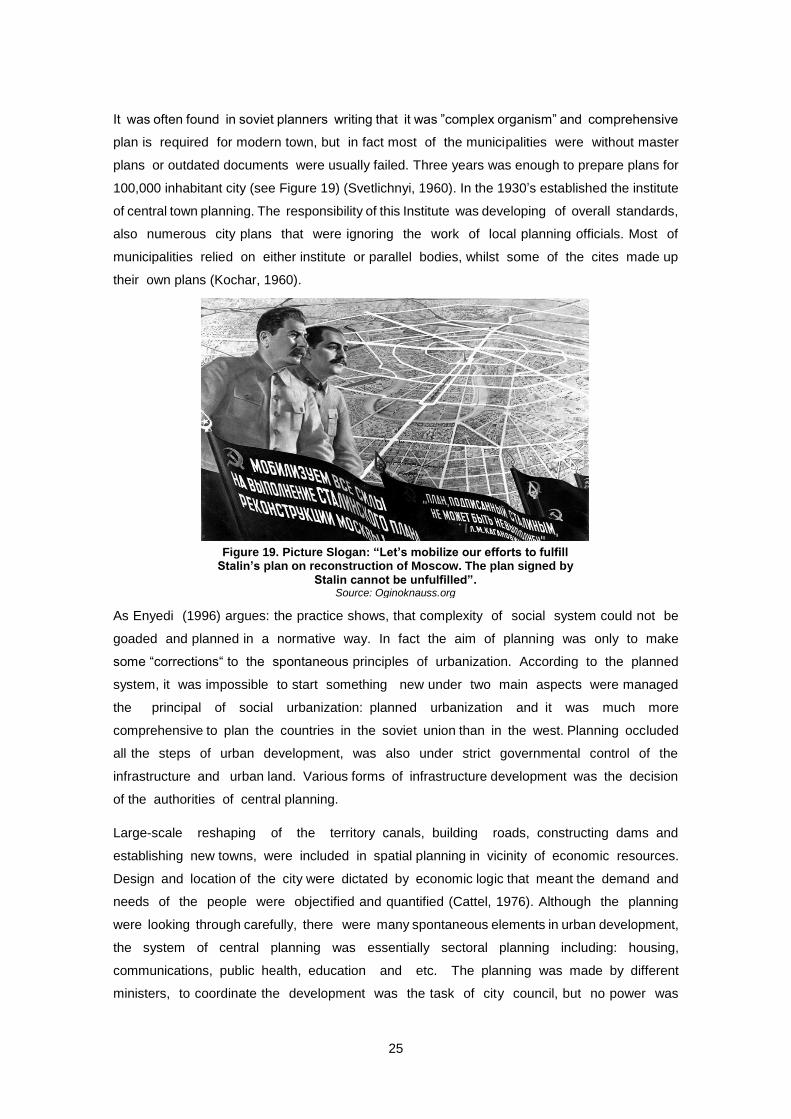
plans or outdated documents were usually failed. Three years was enough to prepare plans for
100,000 inhabitant city (see Figure 19) (Svetlichnyi, 1960). In the 1930’s established the institute
of central town planning. The responsibility of this Institute was developing of overall standards,
also numerous city plans that were ignoring the work of local planning officials. Most of
municipalities relied on either institute or parallel bodies, whilst some of the cites made up
their own plans (Kochar, 1960).
As Enyedi (1996) argues: the practice shows, that complexity of social system could not be
goaded and planned in a normative way. In fact the aim of planning was only to make
some “corrections“ to the spontaneous principles of urbanization. According to the planned
system, it was impossible to start something new under two main aspects were managed
the principal of social urbanization: planned urbanization and it was much more
comprehensive to plan the countries in the soviet union than in the west. Planning occluded
all the steps of urban development, was also under strict governmental control of the
infrastructure and urban land. Various forms of infrastructure development was the decision
of the authorities of central planning.
Large-scale reshaping of the territory canals, building roads, constructing dams and
establishing new towns, were included in spatial planning in vicinity of economic resources.
Design and location of the city were dictated by economic logic that meant the demand and
needs of the people were objectified and quantified (Cattel, 1976). Although the planning
were looking through carefully, there were many spontaneous elements in urban development,
the system of central planning was essentially sectoral planning including: housing,
communications, public health, education and etc. The planning was made by different
ministers, to coordinate the development was the task of city council, but no power was
Figure 19. Picture Slogan: “Let’s mobilize our efforts to fulfill Stalin’s plan on reconstruction of Moscow. The plan signed by
Stalin cannot be unfulfilled”. Source: Oginoknauss.org
26
given to them for making their decisions (Enyedi, 1996). There were clear parallels between
soviet planning experience and British during the early post war years. Both of these
systems used the lands owned by the public, it was considerate a temporary phenomenon
in Britain. Approximately 90% of new houses were built by the public sector in the 1940’s and
early 1950’s (McKay & Cox, 1979).
The major change was brought to the soviet union with the death of Stalin in march 1953
and replace him by the Khrushchev. The better strategy and cooperation with west to improve
the living standards, of social people and better relations were two important aspects that
came with Khrushchev, for improving housing planning system deserved most of his attention
(Ruble, 1993). In December 1954 he gave a speech about the topic of soviet architects and
construction professionals that was known as an discriminating of Stalinists policies (Ward,
2012). In 1950’s Increased productivity and modernistic in urban planning replaced the
traditional street structures, that caused placement of building with freely, scattered buildings
Le Corbusier’s Arcadian dream of towers was better accomplished here than anywhere else.
The most important is that they made their steps that of course is not officially known, to
follow already built welfare in Europe. Oppressive but ample space was in Stalinist and also in
modernist Soviet cities. At that time western Europe was the place where the authorities
built the society mixing with British, French and Northern European ideas together. In Soviet
urban space feature was visible lack of unclear public spaces. Even though the place was
plentiful in Stalinists and also in modernist soviet cities the buildings were being built poorly and
with undeveloped services (Cinis et al., 2008).
Accelerated decay of the system was the main line of soviet epoch. It was clear that the
overburden of available resources was the reason of a deep crisis of a strong planned
economy of the system. It was followed rigid prevention by the state of requirement for consumer
goods and real estate that was causing the private capital arose through shadow economy.
Ideology of soviet system was formalized high communist ideals and trying to denounce
capitalist society. Had strongly connected of social intellectual life the result of all afford was
the fact it became the subject of nihilism and irony. The strict international isolation of soviet
union created distorted imagination of prohibited world. That was idealized in the soviet
reality, on the other hand of creating the collective misunderstanding, western propaganda
played its role perfectly. 1980’s strong popular distrust of the Soviet Union was increased
stagnation of the soviet system (Asabashvili, 2011). In consideration of social needs of
community the planning is torn between the recognition of legitimacy of the choice of
individuals and the desire to require certain levels of consumption. As a matter of fact,
there is not a society ever has found reasonable method of widening choice for all social
groups, or individuals at the limitation of one man’s choice for the lack of the choice of
another (Dyckman, 1966).
27
4.2 Transformation and Urban Reality of Post-Soviet Cities
The plurality of socialism and diversity of post-socialist transformations and experiences is rightly
emphasized in the critical literature on the studies of Eastern European and former Soviet
societies under transition (Hann, 2002). After the fact that state socialism was broken, central
and eastern European cities were under the carried out changes, the process and
mechanism of changes was strongly different from western cities. Legacy of socialism can
be considered as a main aspect of structure of post-socialist cities. Changes in the national
stages of transformation were different and influenced by not only the post-socialist heritage, but
also by contemporary drivers. The current forces also contribute to establish new processes
(Grazuleviciute- Vileniske & Urbonas, 2014).
“Post Socialist Urbanism” and its specific distinctions in (re)configurations of public places and its
significance for residents, have rarely been discussed in the social sciences. Due to the
privatization processes the citizens were uninformed about increasing significance of land
value like shopping malls, cafes and restaurants in peripheral and central parts of the city
(Darieva et al., 2011). According to the post socialist world, it was often introduced with
new liberalism as a “shock of therapy” in the 1990’s. It included global network of transition
industry and elite manipulation, in order to simplify the forms which were more neoliberal
than it was planned by the “shock of therapy” (Hirt et al., 2013). Number of new players was
populated in the urban planning in the 1990’s, in fact they were related to the distribution of
spatial assets. Higher echelons did strategic planning but for the most part city planners were
called upon by the central bureaucracy and handed down goals which they were to follow without
debate (Stalinov, 2007).
The great changes started after the collapse of the Soviet Union. The economy was under
strong control due to the soviet time, as widely begun free market policies by the new
political leaders in post-soviet republics and Georgia was among them (Asabashvili,
2011). The cities of central and eastern Europe should not be approached from the
perspective of the western urbanization. According to Sykora and Bouzarovski (2012) the main
topic of argument is that the process of more fundamental restriction of urban morphology
of the central and eastern European cities is still ongoing, while the transformation of main
economic and political principles is formally over. Then, as Wiest (2012) interprets, western-
centric spatial concepts are determined from certain semantic scope which may not belong to the
specific social and cultural contexts of Central and Eastern European cities. Comparing to each
other the cities of their regions, the Eastern European planners through shared observation and
experiences arrived at two main principles: dispersal and multi nucleation. These were considered
to be the key characteristics of modern urban settlement of twenty first century. The main problem
of planning phases was the failure of planners that included public in meaningful ways
though all places during planning (Stalinov, 2007).
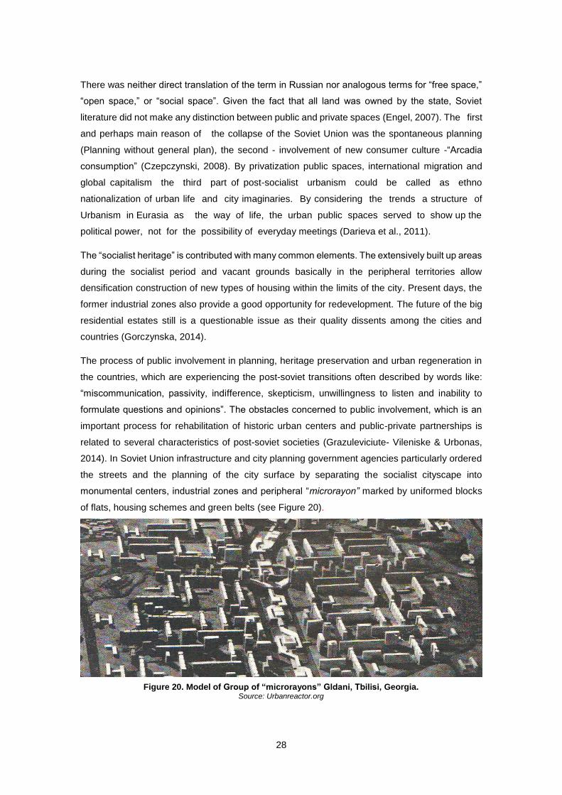
28
There was neither direct translation of the term in Russian nor analogous terms for “free space,”
“open space,” or “social space”. Given the fact that all land was owned by the state, Soviet
literature did not make any distinction between public and private spaces (Engel, 2007). The first
and perhaps main reason of the collapse of the Soviet Union was the spontaneous planning
(Planning without general plan), the second - involvement of new consumer culture -“Arcadia
consumption” (Czepczynski, 2008). By privatization public spaces, international migration and
global capitalism the third part of post-socialist urbanism could be called as ethno
nationalization of urban life and city imaginaries. By considering the trends a structure of
Urbanism in Eurasia as the way of life, the urban public spaces served to show up the
political power, not for the possibility of everyday meetings (Darieva et al., 2011).
The “socialist heritage” is contributed with many common elements. The extensively built up areas
during the socialist period and vacant grounds basically in the peripheral territories allow
densification construction of new types of housing within the limits of the city. Present days, the
former industrial zones also provide a good opportunity for redevelopment. The future of the big
residential estates still is a questionable issue as their quality dissents among the cities and
countries (Gorczynska, 2014).
The process of public involvement in planning, heritage preservation and urban regeneration in
the countries, which are experiencing the post-soviet transitions often described by words like:
“miscommunication, passivity, indifference, skepticism, unwillingness to listen and inability to
formulate questions and opinions”. The obstacles concerned to public involvement, which is an
important process for rehabilitation of historic urban centers and public-private partnerships is
related to several characteristics of post-soviet societies (Grazuleviciute- Vileniske & Urbonas,
2014). In Soviet Union infrastructure and city planning government agencies particularly ordered
the streets and the planning of the city surface by separating the socialist cityscape into
monumental centers, industrial zones and peripheral “microrayon” marked by uniformed blocks
of flats, housing schemes and green belts (see Figure 20).
Figure 20. Model of Group of “microrayons” Gldani, Tbilisi, Georgia. Source: Urbanreactor.org
29
Nowadays, in post-soviet cites is still visible this hierarchical spatial separation of city zones
(Darieva et al., 2011). Due to character, the Soviet planning system was not applicable to the new
reality, in a time when there were no alternative strategic plans created. Old soviet regulations
were formally expanded, but given their inadequacy, they were extremely inefficient in the new
reality. As the government mechanism, which was dealing with the housing construction was
failed, the leading role was taken by the construction businesses, which were emerging quickly
and took a privilege of the situation: no control system, prosperous corruption and crime in the
country, all of these gave raise to uncontrolled developments in the town centers. The massive
constructions in public parks, squares, without any primary norms of planning, design or
construction applied. Today in Georgia, the legacy of the 90’s is still visible. The development
policy based on the Neoliberal market has just become formalized. Therefore, anyone who can
pay a fee can build above the height and volume limits, against the rules (Asabashvili, 2011).
Nowadays, it looks like the “unknown order” and informality of post-communist Urbanism of the
90’s is turning into a new conjunction, inclusive the return to power of the strong leading state, a
reduction of spatial regime imposed by state and neoliberal capital. After the collapse of the Soviet
Union, all the planned socialist towns underwent the radical transformations. Some of them have
successfully established in the new conditions, others have started shortening or have been re-
separated and others became like “open air museums of socialism” (Balockaite, 2010).
4.2.1 Riverfront Transformation in Post-Soviet cities
The riverfront plays a key role in the process of development of a city. Given the main features:
connection to the river and intricacy, the riverfront steers the space production on the river’s edges
(Marshall, 2001). But riverfront reshaping frequently problematically occurs between private and
public, function and urban environment, heritage and new investments areas, there are “a lot of
evidence collected in diverse cultural, political and economic settings to proof the revitalizing
phenomenon of waterfronts” (Hoyle, 2000).
In Warsaw, Moscow and Tbilisi, riverfront areas are undergoing rapid transformation. Dynamic
adaptation of new political and economic conditions strongly reflected on urban riverfronts.
This was the reason why the industrial decentralization in post-socialist cities was delayed.
Globalization of real estate market is changing the social spatial structure. According to these
aspects the riverfronts became the conflict areas (Machala, 2014). Waterfronts are usually used
as pro-growth strategies in the developing cities. Waterfronts are often tasks of experiments,
therefore the number of geographers made their research on it and waterfronts are being
analyzed by them from various perspectives, such as symbolic value of waterfronts regarding
the city planning or the marketing (Short et al., 1993).
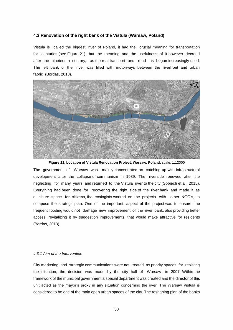
30
4.3 Renovation of the right bank of the Vistula (Warsaw, Poland)
Vistula is called the biggest river of Poland, it had the crucial meaning for transportation
for centuries (see Figure 21), but the meaning and the usefulness of it however decreed
after the nineteenth century, as the real transport and road as began increasingly used.
The left bank of the river was filled with motorways between the riverfront and urban
fabric (Bordas, 2013).
The government of Warsaw was mainly concentrated on catching up with infrastructural
development after the collapse of communism in 1989. The riverside renewed after the
neglecting for many years and returned to the Vistula river to the city (Sobiech et al., 2015).
Everything had been done for recovering the right side of the river bank and made it as
a leisure space for citizens, the ecologists worked on the projects with other NGO’s, to
compose the strategic plan. One of the important aspect of the project was to ensure the
frequent flooding would not damage new improvement of the river bank, also providing better
access, revitalizing it by suggestion improvements, that would make attractive for residents
(Bordas, 2013).
4.3.1 Aim of the Intervention
City marketing and strategic communications were not treated as priority spaces, for resisting
the situation, the decision was made by the city hall of Warsaw in 2007. Within the
framework of the municipal government a special department was created and the director of this
unit acted as the mayor’s proxy in any situation concerning the river. The Warsaw Vistula is
considered to be one of the main open urban spaces of the city. The reshaping plan of the banks
Figure 21. Location of Vistula Renovation Project. Warsaw, Poland, scale: 1:12000
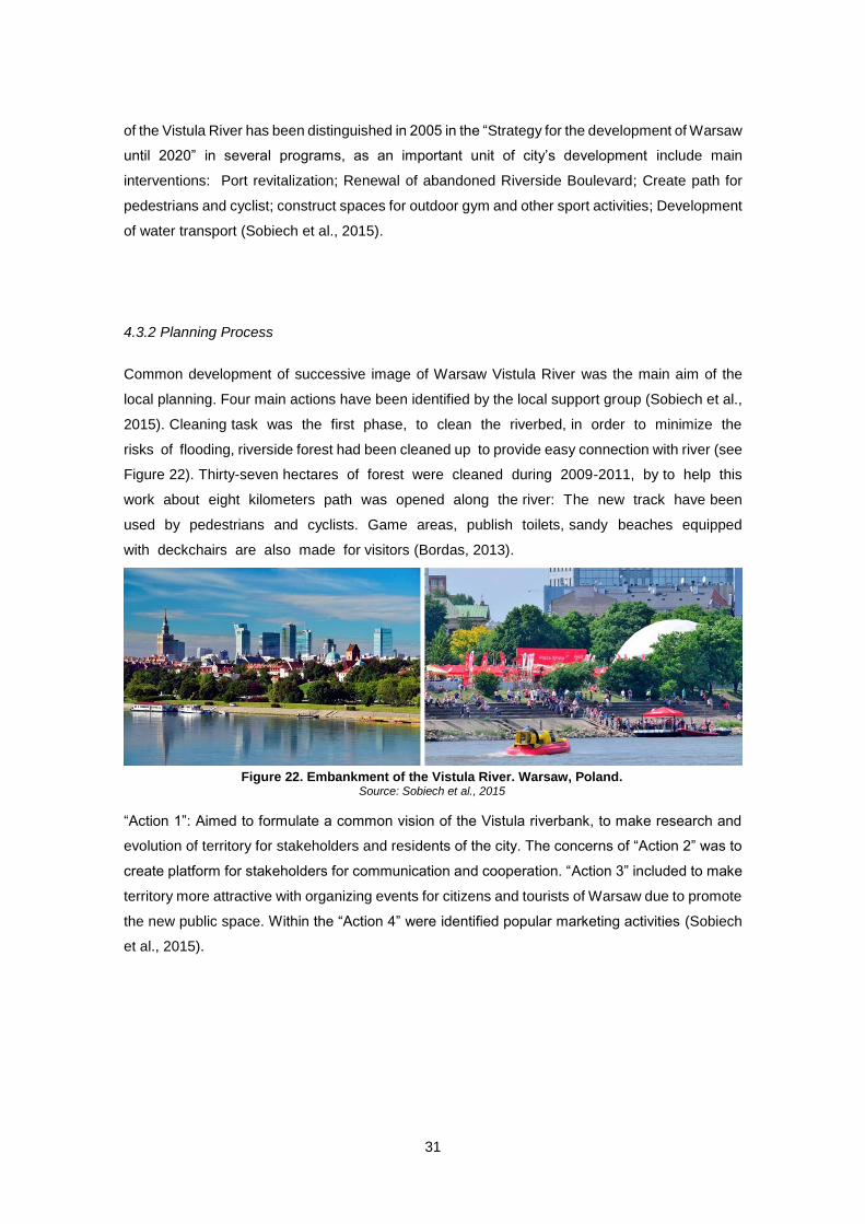
31
of the Vistula River has been distinguished in 2005 in the “Strategy for the development of Warsaw
until 2020” in several programs, as an important unit of city’s development include main
interventions: Port revitalization; Renewal of abandoned Riverside Boulevard; Create path for
pedestrians and cyclist; construct spaces for outdoor gym and other sport activities; Development
of water transport (Sobiech et al., 2015).
4.3.2 Planning Process
Common development of successive image of Warsaw Vistula River was the main aim of the
local planning. Four main actions have been identified by the local support group (Sobiech et al.,
2015). Cleaning task was the first phase, to clean the riverbed, in order to minimize the
risks of flooding, riverside forest had been cleaned up to provide easy connection with river (see
Figure 22). Thirty-seven hectares of forest were cleaned during 2009-2011, by to help this
work about eight kilometers path was opened along the river: The new track have been
used by pedestrians and cyclists. Game areas, publish toilets, sandy beaches equipped
with deckchairs are also made for visitors (Bordas, 2013).
“Action 1”: Aimed to formulate a common vision of the Vistula riverbank, to make research and
evolution of territory for stakeholders and residents of the city. The concerns of “Action 2” was to
create platform for stakeholders for communication and cooperation. “Action 3” included to make
territory more attractive with organizing events for citizens and tourists of Warsaw due to promote
the new public space. Within the “Action 4” were identified popular marketing activities (Sobiech
et al., 2015).
Figure 22. Embankment of the Vistula River. Warsaw, Poland. Source: Sobiech et al., 2015
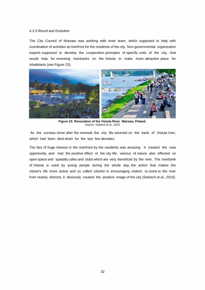
32
4.3.3 Result and Evolution
The City Council of Warsaw was working with inner team, which supposed to help with
coordination of activities at riverfront for the residents of the city. Non-governmental organization
experts supposed to develop the cooperation principles of specific units of the city, that
would help for renewing riverbanks on the Vistula to make more attractive place for
inhabitants (see Figure 23).
As the surveys show after the renewal, the city life returned on the bank of Vistula river,
which had been died down for the last few decades.
The fact of huge interest in the riverfront by the residents was amazing. It created the new
opportunity and had the positive effect of the city life, various of nature also effected on
open space and spatially cafes and clubs which are very beneficial by the river. The riverbank
of Vistula is used by young people during the whole day, the action that makes the
citizen's life more active and so called colorful is encouraging visitors to come to the river
from nearby districts, it obviously created the positive image of the city (Sobiech et al., 2015).
Figure 23. Renovation of the Vistula River. Warsaw, Poland. Source: Sobiech et al., 2015
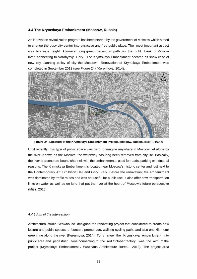
33
4.4 The Krymskaya Embankment (Moscow, Russia)
An innovation revitalization program has been started by the government of Moscow which aimed
to change the busy city center into attractive and free public place. The most important aspect
was to create eight kilometer long green pedestrian path on the right bank of Moskva
river connecting to Vorobyovy Gory. The Krymskaya Embankment became as show case of
new city planning policy of city the Moscow. Renovation of Krymskaya Embankment was
completed in September 2013 (see Figure 24) (Kereimova, 2014).
Until recently, this type of public space was hard to imagine anywhere in Moscow, let alone by
the river. Known as the Moskva, the waterway has long been removed from city life. Basically,
the river is a concrete-bound channel, with the embankments, used for roads, parking or industrial
reasons. The Krymskaya Embankment is located near Moscow’s historic center and just next to
the Contemporary Art Exhibition Hall and Gorki Park. Before the renovation, the embankment
was dominated by traffic routes and was not useful for public use. It also offer new transportation
links on water as well as on land that put the river at the heart of Moscow’s future perspective
(Misir, 2015).
4.4.1 Aim of the Intervention
Architectural studio “Wawhouse” designed the renovating project that considered to create new
leisure and public spaces, a fountain, promenade, walking-cycling paths and also one kilometer
green line along the river (Kereimova, 2014). To change the Krymskaya embankment into
public area and pedestrian zone connecting to the red October factory was the aim of the
project (Krymskaya Embankment / Wowhaus Architecture Bureau, 2013). The project area
Figure 24. Location of the Krymskaya Embankment Project. Moscow, Russia, scale 1:10000
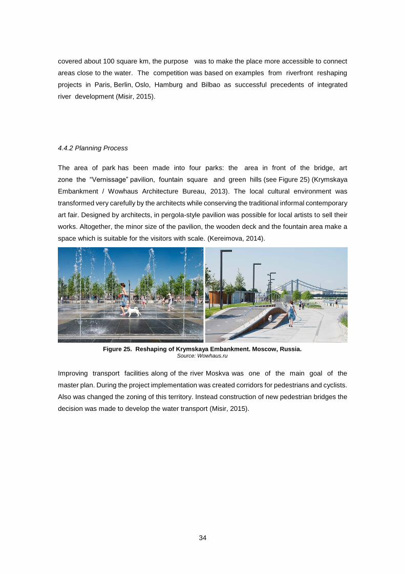
34
covered about 100 square km, the purpose was to make the place more accessible to connect
areas close to the water. The competition was based on examples from riverfront reshaping
projects in Paris, Berlin, Oslo, Hamburg and Bilbao as successful precedents of integrated
river development (Misir, 2015).
4.4.2 Planning Process
The area of park has been made into four parks: the area in front of the bridge, art
zone the “Vernissage” pavilion, fountain square and green hills (see Figure 25) (Krymskaya
Embankment / Wowhaus Architecture Bureau, 2013). The local cultural environment was
transformed very carefully by the architects while conserving the traditional informal contemporary
art fair. Designed by architects, in pergola-style pavilion was possible for local artists to sell their
works. Altogether, the minor size of the pavilion, the wooden deck and the fountain area make a
space which is suitable for the visitors with scale. (Kereimova, 2014).
Improving transport facilities along of the river Moskva was one of the main goal of the
master plan. During the project implementation was created corridors for pedestrians and cyclists.
Also was changed the zoning of this territory. Instead construction of new pedestrian bridges the
decision was made to develop the water transport (Misir, 2015).
Figure 25. Reshaping of Krymskaya Embankment. Moscow, Russia. Source: Wowhaus.ru
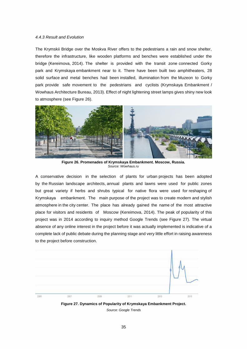
35
4.4.3 Result and Evolution
The Krymskii Bridge over the Moskva River offers to the pedestrians a rain and snow shelter,
therefore the infrastructure, like wooden platforms and benches were established under the
bridge (Kereimova, 2014). The shelter is provided with the transit zone connected Gorky
park and Krymskaya embankment near to it. There have been built two amphitheaters, 28
solid surface and metal benches had been installed, illumination from the Muzeon to Gorky
park provide safe movement to the pedestrians and cyclists (Krymskaya Embankment /
Wowhaus Architecture Bureau, 2013). Effect of night lightening street lamps gives shiny new look
to atmosphere (see Figure 26).
A conservative decision in the selection of plants for urban projects has been adopted
by the Russian landscape architects, annual plants and lawns were used for public zones
but great variety if herbs and shrubs typical for native flora were used for reshaping of
Krymskaya embankment. The main purpose of the project was to create modern and stylish
atmosphere in the city center. The place has already gained the name of the most attractive
place for visitors and residents of Moscow (Kereimova, 2014). The peak of popularity of this
project was in 2014 according to inquiry method Google Trends (see Figure 27). The virtual
absence of any online interest in the project before it was actually implemented is indicative of a
complete lack of public debate during the planning stage and very little effort in raising awareness
to the project before construction.
Figure 26. Promenades of Krymskaya Embankment. Moscow, Russia. Source: Wowhaus.ru
Figure 27. Dynamics of Popularity of Krymskaya Embankment Project.
Source: Google Trends
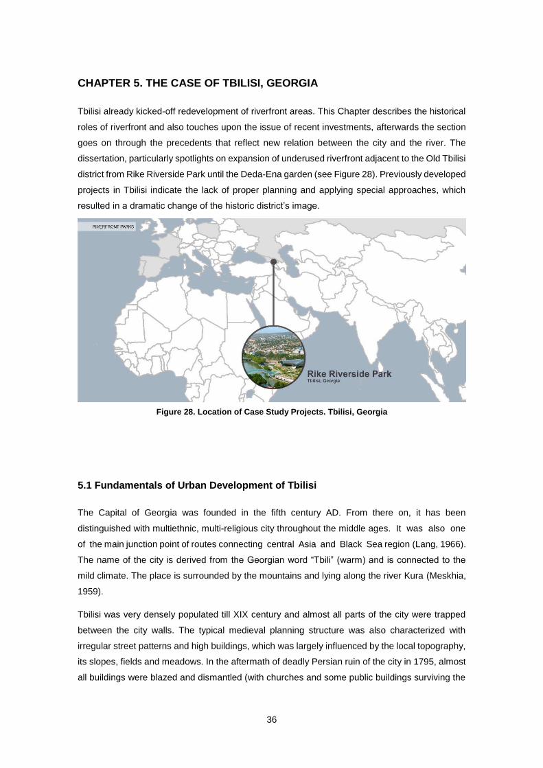
36
CHAPTER 5. THE CASE OF TBILISI, GEORGIA
Tbilisi already kicked-off redevelopment of riverfront areas. This Chapter describes the historical
roles of riverfront and also touches upon the issue of recent investments, afterwards the section
goes on through the precedents that reflect new relation between the city and the river. The
dissertation, particularly spotlights on expansion of underused riverfront adjacent to the Old Tbilisi
district from Rike Riverside Park until the Deda-Ena garden (see Figure 28). Previously developed
projects in Tbilisi indicate the lack of proper planning and applying special approaches, which
resulted in a dramatic change of the historic district’s image.
5.1 Fundamentals of Urban Development of Tbilisi
The Capital of Georgia was founded in the fifth century AD. From there on, it has been
distinguished with multiethnic, multi-religious city throughout the middle ages. It was also one
of the main junction point of routes connecting central Asia and Black Sea region (Lang, 1966).
The name of the city is derived from the Georgian word “Tbili” (warm) and is connected to the
mild climate. The place is surrounded by the mountains and lying along the river Kura (Meskhia,
1959).
Tbilisi was very densely populated till XIX century and almost all parts of the city were trapped
between the city walls. The typical medieval planning structure was also characterized with
irregular street patterns and high buildings, which was largely influenced by the local topography,
its slopes, fields and meadows. In the aftermath of deadly Persian ruin of the city in 1795, almost
all buildings were blazed and dismantled (with churches and some public buildings surviving the
Figure 28. Location of Case Study Projects. Tbilisi, Georgia
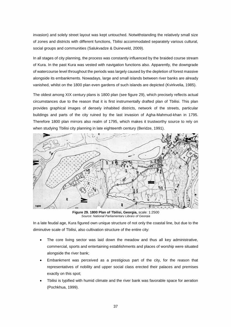
37
invasion) and solely street layout was kept untouched. Notwithstanding the relatively small size
of zones and districts with different functions, Tbilisi accommodated separately various cultural,
social groups and communities (Salukvadze & Duineveld, 2009).
In all stages of city planning, the process was constantly influenced by the braided course stream
of Kura. In the past Kura was vested with navigation functions also. Apparently, the downgrade
of watercourse level throughout the periods was largely caused by the depletion of forest massive
alongside its embankments. Nowadays, large and small islands between river banks are already
vanished, whilst on the 1800 plan even gardens of such islands are depicted (Kvirkvelia, 1985).
The oldest among XIX century plans is 1800 plan (see figure 29), which precisely reflects actual
circumstances due to the reason that it is first instrumentally drafted plan of Tbilisi. This plan
provides graphical images of densely inhabited districts, network of the streets, particular
buildings and parts of the city ruined by the last invasion of Agha-Mahmud-khan in 1795.
Therefore 1800 plan mirrors also realm of 1795, which makes it trustworthy source to rely on
when studying Tbilisi city planning in late eighteenth century (Beridze, 1991).
In a late feudal age, Kura figured own unique structure of not only the coastal line, but due to the
diminutive scale of Tbilisi, also cultivation structure of the entire city:
The core living sector was laid down the meadow and thus all key administrative,
commercial, sports and entertaining establishments and places of worship were situated
alongside the river bank;
Embankment was perceived as a prestigious part of the city, for the reason that
representatives of nobility and upper social class erected their palaces and premises
exactly on this spot;
Tbilisi is typified with humid climate and the river bank was favorable space for aeration
(Pochkhua, 1999).
Figure 29. 1800 Plan of Tbilisi, Georgia, scale: 1:2500 Source: National Parliamentary Library of Georgia
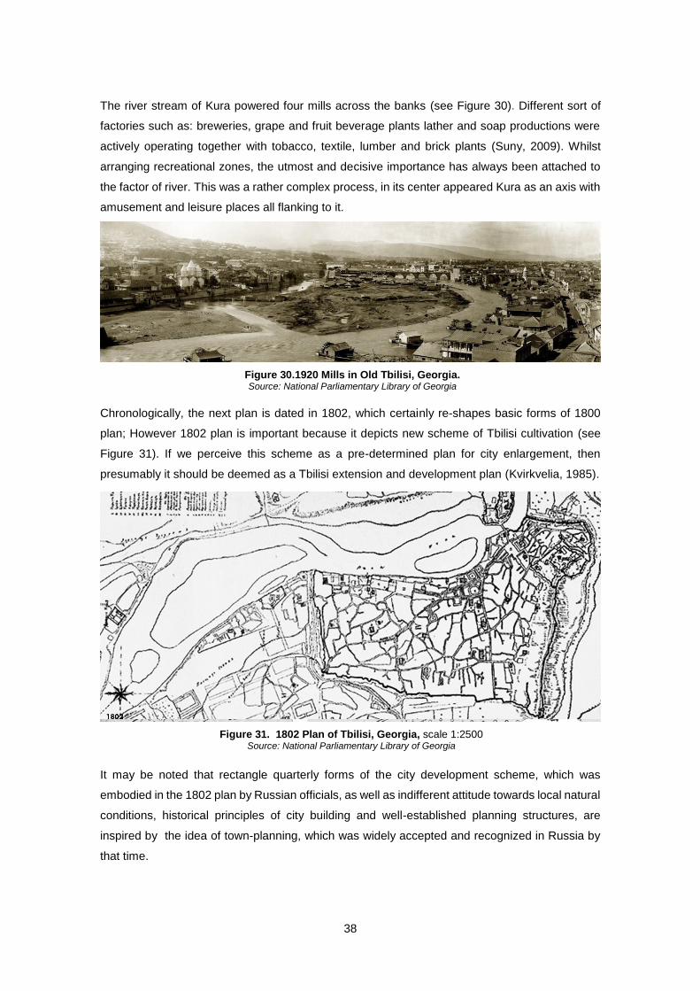
38
The river stream of Kura powered four mills across the banks (see Figure 30). Different sort of
factories such as: breweries, grape and fruit beverage plants lather and soap productions were
actively operating together with tobacco, textile, lumber and brick plants (Suny, 2009). Whilst
arranging recreational zones, the utmost and decisive importance has always been attached to
the factor of river. This was a rather complex process, in its center appeared Kura as an axis with
amusement and leisure places all flanking to it.
Chronologically, the next plan is dated in 1802, which certainly re-shapes basic forms of 1800
plan; However 1802 plan is important because it depicts new scheme of Tbilisi cultivation (see
Figure 31). If we perceive this scheme as a pre-determined plan for city enlargement, then
presumably it should be deemed as a Tbilisi extension and development plan (Kvirkvelia, 1985).
It may be noted that rectangle quarterly forms of the city development scheme, which was
embodied in the 1802 plan by Russian officials, as well as indifferent attitude towards local natural
conditions, historical principles of city building and well-established planning structures, are
inspired by the idea of town-planning, which was widely accepted and recognized in Russia by
that time.
Figure 30.1920 Mills in Old Tbilisi, Georgia. Source: National Parliamentary Library of Georgia
Figure 31. 1802 Plan of Tbilisi, Georgia, scale 1:2500 Source: National Parliamentary Library of Georgia
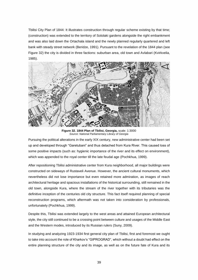
39
Tbilisi City Plan of 1844: It illustrates construction through regular scheme existing by that time;
(construction) was extended to the territory of Sololaki gardens alongside the right embankment
and was also laid down the Ortachala island and the newly planned regularly quartered and left
bank with steady street network (Beridze, 1991). Pursuant to the revelation of the 1844 plan (see
Figure 32) the city is divided in three factions: suburban area, old town and Avlabari (Kvirkvelia,
1985).
Pursuing the political alterations in the early XIX century, new administrative center had been set
up and developed through “Garetubani” and thus detached from Kura River. This caused loss of
some positive impacts (such as: hygienic importance of the river and its effect on environment),
which was appended to the royal center till the late feudal age (Pochkhua, 1999).
After repositioning Tbilisi administrative center from Kura neighborhood, all major buildings were
constructed on sideways of Rustaveli Avenue. However, the ancient cultural monuments, which
nevertheless did not lose importance but even retained more admiration, as images of reach
architectural heritage and spacious installations of the historical surrounding, still remained in the
old town, alongside Kura, where the stream of the river together with its tributaries was the
definitive inception of the centuries old city structure. This fact itself required planning of special
reconstruction programs, which aftermath was not taken into consideration by professionals,
unfortunately (Pochkhua, 1999).
Despite this, Tbilisi was extended largely to the west areas and attained European architectural
style, the city still continued to be a crossing point between culture and usages of the Middle East
and the Western modes, introduced by its Russian rulers (Suny, 2009).
In studying and analyzing 1923-1934 first general city plan of Tbilisi, first and foremost we ought
to take into account the role of Kharkov’s “GIPROGRAD”, which without a doubt had effect on the
entire planning structure of the city and its image, as well as on the future fate of Kura and its
Figure 32. 1844 Plan of Tbilisi, Georgia, scale: 1:3000 Source: National Parliamentary Library of Georgia
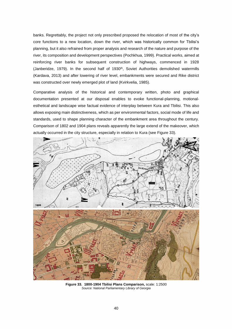
40
banks. Regrettably, the project not only prescribed proposed the relocation of most of the city’s
core functions to a new location, down the river, which was historically common for Tbilisi’s
planning, but it also refrained from proper analysis and research of the nature and purpose of the
river, its composition and development perspectives (Pochkhua, 1999). Practical works, aimed at
reinforcing river banks for subsequent construction of highways, commenced in 1928
(Janberidze, 1979). In the second half of 1930th, Soviet Authorities demolished watermills
(Kardava, 2013) and after lowering of river level, embankments were secured and Rike district
was constructed over newly emerged plot of land (Kvirkvelia, 1985).
Comparative analysis of the historical and contemporary written, photo and graphical
documentation presented at our disposal enables to evoke functional-planning, motional-
esthetical and landscape wise factual evidence of interplay between Kura and Tbilisi. This also
allows exposing main distinctiveness, which as per environmental factors, social mode of life and
standards, used to shape planning character of the embankment area throughout the century.
Comparison of 1802 and 1904 plans reveals apparently the large extend of the makeover, which
actually occurred in the city structure, especially in relation to Kura (see Figure 33).
Figure 33. 1800-1904 Tbilisi Plans Comparison, scale: 1:2500 Source: National Parliamentary Library of Georgia
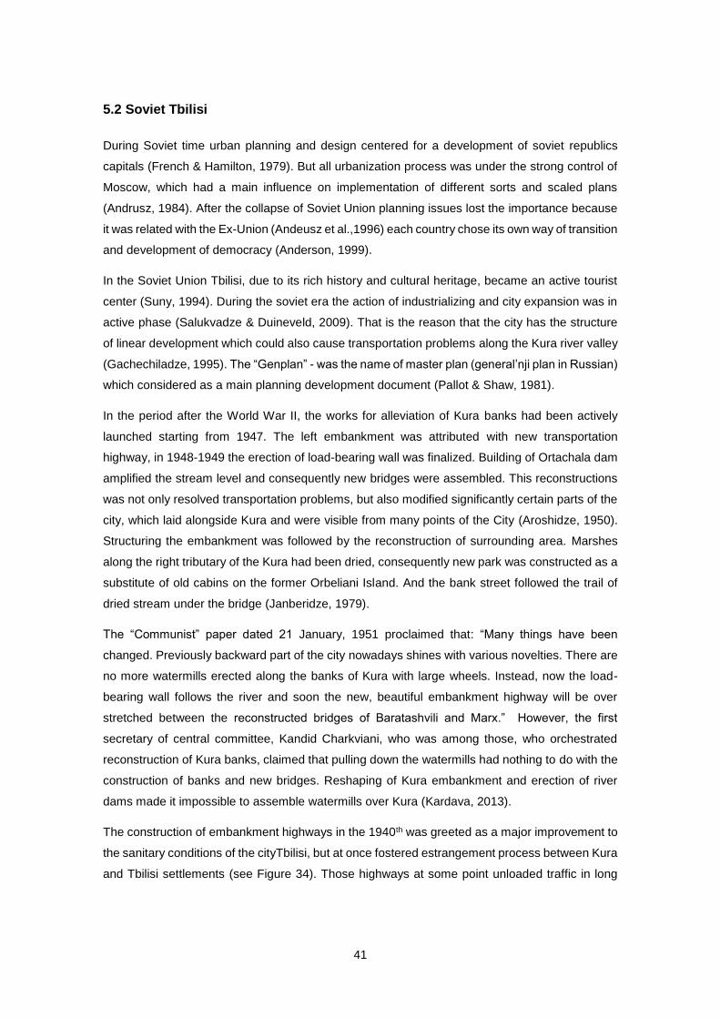
41
5.2 Soviet Tbilisi
During Soviet time urban planning and design centered for a development of soviet republics
capitals (French & Hamilton, 1979). But all urbanization process was under the strong control of
Moscow, which had a main influence on implementation of different sorts and scaled plans
(Andrusz, 1984). After the collapse of Soviet Union planning issues lost the importance because
it was related with the Ex-Union (Andeusz et al.,1996) each country chose its own way of transition
and development of democracy (Anderson, 1999).
In the Soviet Union Tbilisi, due to its rich history and cultural heritage, became an active tourist
center (Suny, 1994). During the soviet era the action of industrializing and city expansion was in
active phase (Salukvadze & Duineveld, 2009). That is the reason that the city has the structure
of linear development which could also cause transportation problems along the Kura river valley
(Gachechiladze, 1995). The “Genplan” - was the name of master plan (general’nji plan in Russian)
which considered as a main planning development document (Pallot & Shaw, 1981).
In the period after the World War II, the works for alleviation of Kura banks had been actively
launched starting from 1947. The left embankment was attributed with new transportation
highway, in 1948-1949 the erection of load-bearing wall was finalized. Building of Ortachala dam
amplified the stream level and consequently new bridges were assembled. This reconstructions
was not only resolved transportation problems, but also modified significantly certain parts of the
city, which laid alongside Kura and were visible from many points of the City (Aroshidze, 1950).
Structuring the embankment was followed by the reconstruction of surrounding area. Marshes
along the right tributary of the Kura had been dried, consequently new park was constructed as a
substitute of old cabins on the former Orbeliani Island. And the bank street followed the trail of
dried stream under the bridge (Janberidze, 1979).
The “Communist” paper dated 21 January, 1951 proclaimed that: “Many things have been
changed. Previously backward part of the city nowadays shines with various novelties. There are
no more watermills erected along the banks of Kura with large wheels. Instead, now the load-
bearing wall follows the river and soon the new, beautiful embankment highway will be over
stretched between the reconstructed bridges of Baratashvili and Marx.” However, the first
secretary of central committee, Kandid Charkviani, who was among those, who orchestrated
reconstruction of Kura banks, claimed that pulling down the watermills had nothing to do with the
construction of banks and new bridges. Reshaping of Kura embankment and erection of river
dams made it impossible to assemble watermills over Kura (Kardava, 2013).
The construction of embankment highways in the 1940th was greeted as a major improvement to
the sanitary conditions of the cityTbilisi, but at once fostered estrangement process between Kura
and Tbilisi settlements (see Figure 34). Those highways at some point unloaded traffic in long
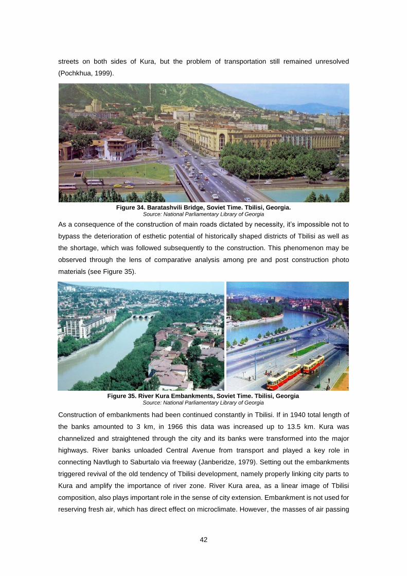
42
streets on both sides of Kura, but the problem of transportation still remained unresolved
(Pochkhua, 1999).
As a consequence of the construction of main roads dictated by necessity, it’s impossible not to
bypass the deterioration of esthetic potential of historically shaped districts of Tbilisi as well as
the shortage, which was followed subsequently to the construction. This phenomenon may be
observed through the lens of comparative analysis among pre and post construction photo
materials (see Figure 35).
Construction of embankments had been continued constantly in Tbilisi. If in 1940 total length of
the banks amounted to 3 km, in 1966 this data was increased up to 13.5 km. Kura was
channelized and straightened through the city and its banks were transformed into the major
highways. River banks unloaded Central Avenue from transport and played a key role in
connecting Navtlugh to Saburtalo via freeway (Janberidze, 1979). Setting out the embankments
triggered revival of the old tendency of Tbilisi development, namely properly linking city parts to
Kura and amplify the importance of river zone. River Kura area, as a linear image of Tbilisi
composition, also plays important role in the sense of city extension. Embankment is not used for
reserving fresh air, which has direct effect on microclimate. However, the masses of air passing
Figure 34. Baratashvili Bridge, Soviet Time. Tbilisi, Georgia. Source: National Parliamentary Library of Georgia
Figure 35. River Kura Embankments, Soviet Time. Tbilisi, Georgia Source: National Parliamentary Library of Georgia

43
alongside the Kura gorge has a best potential for ventilation of the capital. The rock routed tunnel
serves the purpose of preservation of settlements over Metekhi hill and beyond as well as
continuation of high speed freeway alongside the left embankment. Due to the narrow stream of
Kura on the one hand and the rock itself on the other, construction of over ground highway
appeared to be impossible in this particular fragment. Construction of the road would alter existing
scale and cause loss of overall attractiveness of the area, which is characterised with beautiful
balconies dangled along the rock, thus the highway under this section keeps on inside the tunnel.
In 1973, Rike area was dismantled of settlements and recreational zone was planned to be
arranged in there. Meanwhile, Ortachala gardens also attracted Tbilisi inhabitants and constituted
one of the popular social spaces for them (Kvirkvelia, 1985). Regrettably, “Ortachala Gardens”
nowadays can be met only in old historical maps of Tbilisi, and this territory is distributed among
private plots and is experiencing chaotic, disorganized cultivation. Historical map of Tbilisi of 1924
clearly depicts that river Kura used to separate in two tributaries along “Ortachala Gardens”
creating an island. Branching started exactly on the same spot, where Ortachala Power Plant is
constructed now (see Figure 36).
In the Beginning of 1970, elaboration on master plan was commenced and various stakeholders
were actively involved in this process, namely: union of architects, city architect’s office, academic
experts, institutions and universities. Networks of personal ties across the official administration
and multiple roles of individuals in the official system, simplified on the one hand the planning
process and made it more inclusive, but it also carried risks: old patron-client relations could be
reinforced, and corruption could be fostered (Salukvadze & Duineveld, 2009).
During the soviet era, a huge attention was drawn to enhance the state of hygiene and ecology
in the city as well as to arrange recreational places for inhabitants. To that end, in 1979, Institute
“TBILKALAKPROEKTI” drafted “Master Plan of Greening and Watering of Tbilisi for 2000”, which
envisaged four major points, namely:
Figure 36. 1924 Plan of Ortachala Gardens. 1970 photo of this territory. Tbilisi, Georgia. Source: Adapted from National Parliamentary Library of Georgia
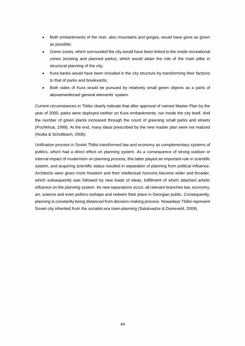
44
Both embankments of the river, also mountains and gorges, would have gone as green
as possible;
Green zones, which surrounded the city would have been linked to the inside recreational
zones (existing and planned parks), which would attain the role of the main pillar in
structural planning of the city;
Kura banks would have been included in the city structure by transforming their factions
to that of parks and boulevards;
Both sides of Kura would be pursued by relatively small green objects as a parts of
abovementioned general elements’ system.
Current circumstances in Tbilisi clearly indicate that after approval of named Master Plan by the
year of 2000, parks were deployed neither on Kura embankments, nor inside the city itself. And
the number of green plants increased through the count of greening small parks and streets
(Pochkhua, 1999). At the end, many ideas prescribed by the new master plan were not realized
(Nodia & Scholtbach, 2006).
Unification process in Soviet Tbilisi transformed law and economy as complementary systems of
politics, which had a direct effect on planning system. As a consequence of strong outdoor or
internal impact of modernism on planning process, this latter played an important role in scientific
system, and acquiring scientific status resulted in separation of planning from political influence.
Architects were given more freedom and their intellectual horizons become wider and broader,
which subsequently was followed by new loads of ideas, fulfillment of which attached artistic
influence on the planning system. As new separations occur, all relevant branches law, economy,
art, science and even politics reshape and redeem their place in Georgian public. Consequently,
planning is constantly being distanced from decision-making process. Nowadays Tbilisi represent
Soviet city inherited from the socialist-era town-planning (Salukvadze & Duineveld, 2009).
45
5.3 Tbilisi in Transition
Break down of the Soviet Union caused dramatic changes in newly independent Georgia. The
country and its capital were unstable, almost defaulted, badly administered and during the first
decade of independence even dangerous (Steavenson, 2004). After gaining independence,
Tbilisi went through periods of disorder and chaos. However, situation stabilized more or less by
the end of the century and which gave opportunity to intensify development activities since 2003.
New developments were followed with rising of new issues in Tbilisi as it was the case in many
other post-Soviet cities. The situation was deteriorated due to the lack of housing systems, green
zones, public spaces, inferiority in constructions and overall disorder (Van Assche & Salukvadze,
2013).
In the aftermath of Soviet Union, peculiarities emerged in terms of adapting 70 years old
communist styled town planning with new reality. However, for architectural circles and specialists
main objectives of planning development were obviously outlined: transformation of totalitarian
and isolated regime of town planning and its integration into the single European, democratic
values based space; pursuing efficient legislative and administrative as well as managerial and
planning reform in line with European standards. Without organized reform in place, undertaking
these changes would give a rise of chaotic development of urban processes and deterioration of
city’s environment. Experience gained through 1991-1993 clearly indicated that the Capital city
would be target of such anticipatory threats as far as it is an urban centre of the country and fully
reflects all key individualities of post-Soviet evolution and controversial developments. Post-
Soviet development of Tbilisi may be separated in three major phases:
Tbilisi town planning;
Total ignorance of architectural-planning and legal principles;
Efforts to overcome town planning challenges.
Thus, political-economic transitions occurring in 1991-1996 had an effect on overall systematic
crisis (Makharashvili, 2008). There were lots of security threats in Tbilisi throughout 1992-94
years, when paramilitary groups roamed the streets and took control over certain areas, which at
some point made authorities to engage in a deal with them (Steavenson, 2004). It is easily
recognizable that in such a risky environment both developers and home buyers wouldn’t dare to
start up development businesses in Tbilisi and since this market was totally unregulated, main
deals were made on black market (Van Assche & Salukvadze, 2013).
Urban problems of Tbilisi, emerged in the aftermath of independence, should be resolved through
applying planning and urban design strategies. This latter, however, cannot constitute part of
regular strategy without placing it under planning framework and planning itself may not be just
without existence of democratic institutions (Kornai & Rose-Ackerman, 2004).
46
The development attempts were kicked off slowly in these years, but stepped up in new millennia
and especially after Rose Revolution of 2003, when so-called “investor urbanism” started
implementation (Ziegler, 2006). The idea of “investor urbanism” lies in collaborative decision
making on large projects together with governmental authorities and well-off investors (Gallina,
2010).
2007 is marked with the open call for preliminary master plan contest, or more precisely for
“General (Operative) Plan of Land-use of Tbilisi”. This plan should have been the ground for a
fully-fledged master-plan. There was consensus among authorities as well as experts on the need
of unified master plan or a similar document for Tbilisi; however opinions were differed on the
design of such plan. Some experts submitted that old-fashioned master plan in a socialist style
would be inefficient and unnecessary. After the distress surrounding this process, in 2009, new
master plan was finally approved, but its implementing impacts seem least even from nowadays
standpoint (Salukvadze & Duineveld, 2009).
5.4 Recent Changes and Problems of Tbilisi’s Riverfront
In subsequent years, environmental issues raised concerns in Georgian politics and thus had
effect on Tbilisi planning. For a certain period it was perceived that every large project would be
based on environmental impact assessments and green urbanism fundamentals would lead the
planning process. However, very important green zones were turned to vulnerable spaces and
parks and protected areas now become residential settlements (Salukvadze & Duineveld, 2009).
Some forms of environmental planning were inherited from the Soviets, but largely lost in the
nineties. There is the legacy of green cities (White, 1980), which is demonstrated in Tbilisi through
the combination of parks, tree-lined avenues, hills, and valleys with construction bans.
The decrease of public space and overall shortage of public domain indicates government’s
inability to organize special zones for public and common usage (see Figure 37). It also indicates
that pubic good still exists, but is badly damaged due to the post-independence wild capitalism
effect. Moreover, it also suggests that nowadays mechanisms are still lacking to redefine public
space and public domain generally in a democratic way without applying strict power of capitalism
or old fashioned Soviet solutions (Shavishvili , 2009). Besides, open spaces between historic part
and newer Soviet period areas, are victim of “investor urbanism” (Gachechiladze, 1990).
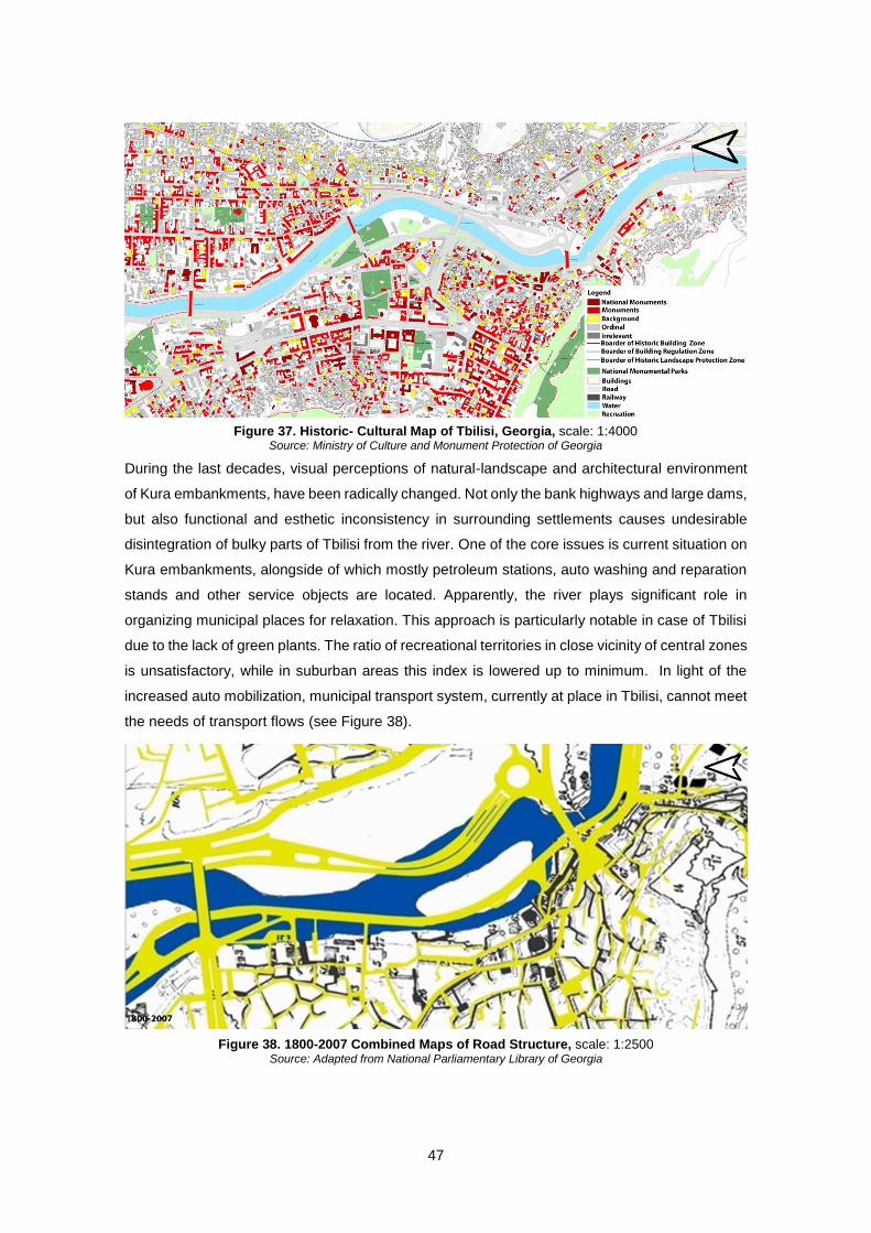
47
During the last decades, visual perceptions of natural-landscape and architectural environment
of Kura embankments, have been radically changed. Not only the bank highways and large dams,
but also functional and esthetic inconsistency in surrounding settlements causes undesirable
disintegration of bulky parts of Tbilisi from the river. One of the core issues is current situation on
Kura embankments, alongside of which mostly petroleum stations, auto washing and reparation
stands and other service objects are located. Apparently, the river plays significant role in
organizing municipal places for relaxation. This approach is particularly notable in case of Tbilisi
due to the lack of green plants. The ratio of recreational territories in close vicinity of central zones
is unsatisfactory, while in suburban areas this index is lowered up to minimum. In light of the
increased auto mobilization, municipal transport system, currently at place in Tbilisi, cannot meet
the needs of transport flows (see Figure 38).
Figure 37. Historic- Cultural Map of Tbilisi, Georgia, scale: 1:4000 Source: Ministry of Culture and Monument Protection of Georgia
Figure 38. 1800-2007 Combined Maps of Road Structure, scale: 1:2500 Source: Adapted from National Parliamentary Library of Georgia
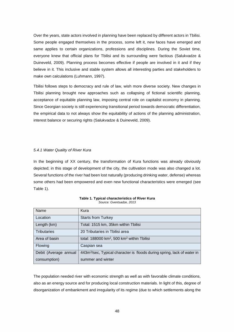
48
Over the years, state actors involved in planning have been replaced by different actors in Tbilisi.
Some people engaged themselves in the process, some left it, new faces have emerged and
same applies to certain organizations, professions and disciplines. During the Soviet time,
everyone knew that official plans for Tbilisi and its surrounding were factious (Salukvadze &
Duineveld, 2009). Planning process becomes effective if people are involved in it and if they
believe in it. This inclusive and stable system allows all interesting parties and stakeholders to
make own calculations (Luhmann, 1997).
Tbilisi follows steps to democracy and rule of law, wish more diverse society. New changes in
Tbilisi planning brought new approaches such as collapsing of fictional scientific planning,
acceptance of equitable planning law, imposing central role on capitalist economy in planning.
Since Georgian society is still experiencing transitional period towards democratic differentiation,
the empirical data to not always show the equitability of actions of the planning administration,
interest balance or securing rights (Salukvadze & Duineveld, 2009).
5.4.1 Water Quality of River Kura
In the beginning of XX century, the transformation of Kura functions was already obviously
depicted; in this stage of development of the city, the cultivation mode was also changed a lot.
Several functions of the river had been lost naturally (producing drinking water, defense) whereas
some others had been empowered and even new functional characteristics were emerged (see
Table 1).
Table 1. Typical characteristics of River Kura Source: Gventsadze, 2013
Name Kura
Location Starts from Turkey
Length (km) Total: 1515 km, 35km within Tbilisi
Tributaries 20 Tributaries in Tbilisi area
Area of basin total: 188000 km2, 500 km2 within Tbilisi
Flowing Caspian sea
Debit (Average annual
consumption)
443m3/sec, Typical character is floods during spring, lack of water in
summer and winter
The population needed river with economic strength as well as with favorable climate conditions,
also as an energy source and for producing local construction materials. In light of this, degree of
disorganization of embankment and irregularity of its regime (due to which settlements along the
49
river suffered a serious injury as a consequence of floods), by the early XX century, was
completely inconsistent with the general image of the city. Kura was assigned with the function of
main collector as a result of its pollution with domestic discharges and industrial wastes. Despite
of this, Kura area did not lose its prestige and attraction for inhabitants of the city with warm
climate. (Pochkhua, 1999)
Through 1940-1950 the old tradition to set recreational zones, such as parks, along the river
banks had been displaced. At the same time, utilization of river waters for technical rationales
fostered the tendency to orient industrial zones around the river basin, which had a critical effect
on esthetical image of banks and on ecology too.
Through the long term research it may be noted that pollution of Kura and its tributaries is getting
higher and subsequently water quality keeps on down within the area of Tbilisi. This process is
being continued even now despite the fact that overall produce and industry is lessened. Sewage
and wastewaters still remain main source of pollution of Kura basin. Current circumstances in
terms of pollution control of Kura and its tributaries are largely impacted by poor functioning of
wastewater system. Existing situation is aggravated by the dawning of water cleaning equipment.
(Gventsadze, 2013)
According to the 7 May, 1998 Order #59 of the Minister of Protection of Environment and Natural
Resources of Georgia on Approving Statute on Protective Water Line, over water objects have
own protective water lines, among them: coastal lines of rivers, lakes, reservoirs, alienation lines
of major and other channels and whereas prevention of pollution, littering, wasting of water
resources is obligatory for public agencies as well as natural persons individuals. Basically,
parameters of rivers’ protective water lines are established by the Law of Georgia on Water, while
Article 17 of the abovementioned Order #49 provides that protective water lines in cities, towns
and village settlements are set out by general plans. (Law of Georgia on Water, 1997)
Unresponsive attitude from authorities towards water cleaning units throughout the years had an
effect of decline of the quality of waters, especially in the historical centre of the city, where the
quality is on critical edge.
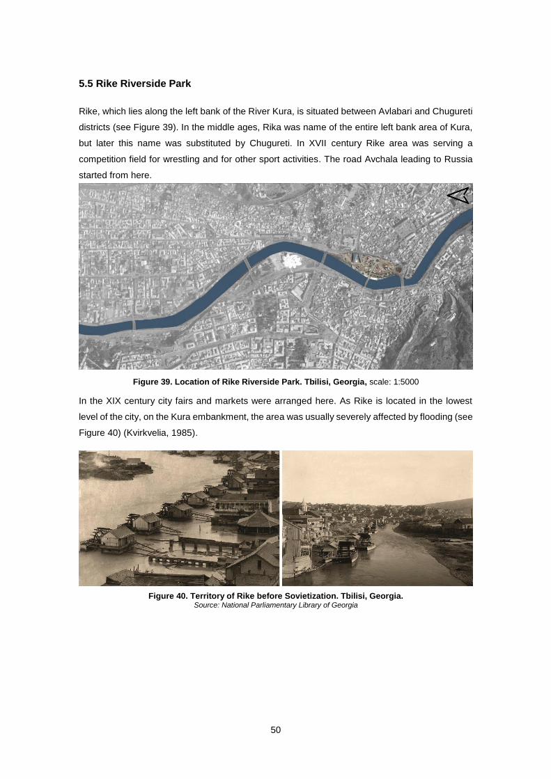
50
5.5 Rike Riverside Park
Rike, which lies along the left bank of the River Kura, is situated between Avlabari and Chugureti
districts (see Figure 39). In the middle ages, Rika was name of the entire left bank area of Kura,
but later this name was substituted by Chugureti. In XVII century Rike area was serving a
competition field for wrestling and for other sport activities. The road Avchala leading to Russia
started from here.
In the XIX century city fairs and markets were arranged here. As Rike is located in the lowest
level of the city, on the Kura embankment, the area was usually severely affected by flooding (see
Figure 40) (Kvirkvelia, 1985).
Figure 39. Location of Rike Riverside Park. Tbilisi, Georgia, scale: 1:5000
Figure 40. Territory of Rike before Sovietization. Tbilisi, Georgia. Source: National Parliamentary Library of Georgia
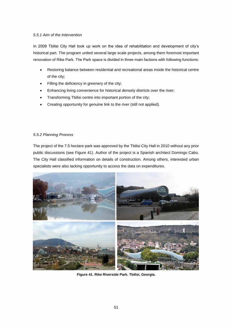
51
5.5.1 Aim of the Intervention
In 2009 Tbilisi City Hall took up work on the idea of rehabilitation and development of city’s
historical part. The program united several large scale projects, among them foremost important
renovation of Rike Park. The Park space is divided in three main factions with following functions:
Restoring balance between residential and recreational areas inside the historical centre
of the city;
Filling the deficiency in greenery of the city;
Enhancing living convenience for historical densely districts over the river;
Transforming Tbilisi centre into important portion of the city;
Creating opportunity for genuine link to the river (still not applied).
5.5.2 Planning Process
The project of the 7.5 hectare park was approved by the Tbilisi City Hall in 2010 without any prior
public discussions (see Figure 41). Author of the project is a Spanish architect Domingo Cabo.
The City Hall classified information on details of construction. Among others, interested urban
specialists were also lacking opportunity to access the data on expenditures.
Figure 41. Rike Riverside Park. Tbilisi, Georgia.
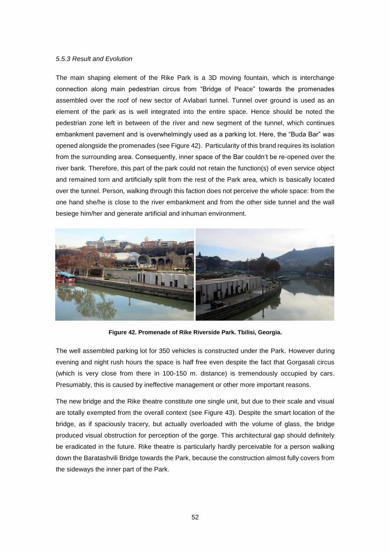
52
5.5.3 Result and Evolution
The main shaping element of the Rike Park is a 3D moving fountain, which is interchange
connection along main pedestrian circus from “Bridge of Peace” towards the promenades
assembled over the roof of new sector of Avlabari tunnel. Tunnel over ground is used as an
element of the park as is well integrated into the entire space. Hence should be noted the
pedestrian zone left in between of the river and new segment of the tunnel, which continues
embankment pavement and is overwhelmingly used as a parking lot. Here, the “Buda Bar” was
opened alongside the promenades (see Figure 42). Particularity of this brand requires its isolation
from the surrounding area. Consequently, inner space of the Bar couldn’t be re-opened over the
river bank. Therefore, this part of the park could not retain the function(s) of even service object
and remained torn and artificially split from the rest of the Park area, which is basically located
over the tunnel. Person, walking through this faction does not perceive the whole space: from the
one hand she/he is close to the river embankment and from the other side tunnel and the wall
besiege him/her and generate artificial and inhuman environment.
The well assembled parking lot for 350 vehicles is constructed under the Park. However during
evening and night rush hours the space is half free even despite the fact that Gorgasali circus
(which is very close from there in 100-150 m. distance) is tremendously occupied by cars.
Presumably, this is caused by ineffective management or other more important reasons.
The new bridge and the Rike theatre constitute one single unit, but due to their scale and visual
are totally exempted from the overall context (see Figure 43). Despite the smart location of the
bridge, as if spaciously tracery, but actually overloaded with the volume of glass, the bridge
produced visual obstruction for perception of the gorge. This architectural gap should definitely
be eradicated in the future. Rike theatre is particularly hardly perceivable for a person walking
down the Baratashvili Bridge towards the Park, because the construction almost fully covers from
the sideways the inner part of the Park.
Figure 42. Promenade of Rike Riverside Park. Tbilisi, Georgia.
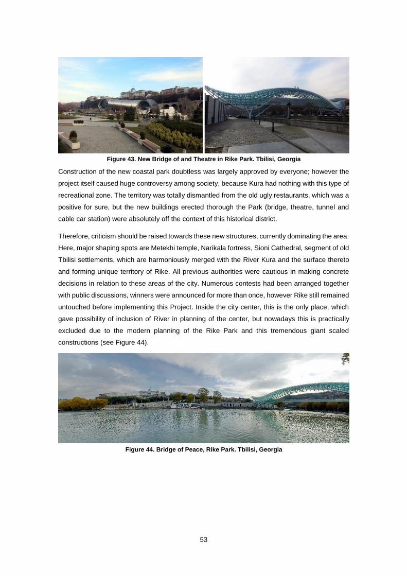
53
Construction of the new coastal park doubtless was largely approved by everyone; however the
project itself caused huge controversy among society, because Kura had nothing with this type of
recreational zone. The territory was totally dismantled from the old ugly restaurants, which was a
positive for sure, but the new buildings erected thorough the Park (bridge, theatre, tunnel and
cable car station) were absolutely off the context of this historical district.
Therefore, criticism should be raised towards these new structures, currently dominating the area.
Here, major shaping spots are Metekhi temple, Narikala fortress, Sioni Cathedral, segment of old
Tbilisi settlements, which are harmoniously merged with the River Kura and the surface thereto
and forming unique territory of Rike. All previous authorities were cautious in making concrete
decisions in relation to these areas of the city. Numerous contests had been arranged together
with public discussions, winners were announced for more than once, however Rike still remained
untouched before implementing this Project. Inside the city center, this is the only place, which
gave possibility of inclusion of River in planning of the center, but nowadays this is practically
excluded due to the modern planning of the Rike Park and this tremendous giant scaled
constructions (see Figure 44).
Figure 43. New Bridge of and Theatre in Rike Park. Tbilisi, Georgia
Figure 44. Bridge of Peace, Rike Park. Tbilisi, Georgia
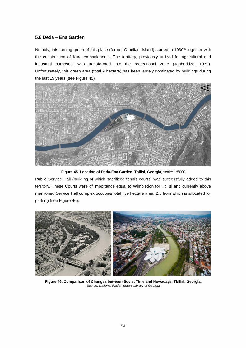
54
5.6 Deda – Ena Garden
Notably, this turning green of this place (former Orbeliani Island) started in 1930th together with
the construction of Kura embankments. The territory, previously utilized for agricultural and
industrial purposes, was transformed into the recreational zone (Janberidze, 1979).
Unfortunately, this green area (total 9 hectare) has been largely dominated by buildings during
the last 15 years (see Figure 45).
Public Service Hall (building of which sacrificed tennis courts) was successfully added to this
territory. These Courts were of importance equal to Wimbledon for Tbilisi and currently above
mentioned Service Hall complex occupies total five hectare area, 2.5 from which is allocated for
parking (see Figure 46).
Figure 45. Location of Deda-Ena Garden. Tbilisi, Georgia, scale: 1:5000
Figure 46. Comparison of Changes between Soviet Time and Nowadays. Tbilisi. Georgia. Source: National Parliamentary Library of Georgia
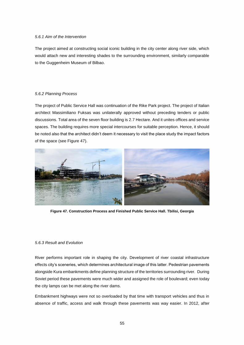
55
5.6.1 Aim of the Intervention
The project aimed at constructing social iconic building in the city center along river side, which
would attach new and interesting shades to the surrounding environment, similarly comparable
to the Guggenheim Museum of Bilbao.
5.6.2 Planning Process
The project of Public Service Hall was continuation of the Rike Park project. The project of Italian
architect Massimiliano Fuksas was unilaterally approved without preceding tenders or public
discussions. Total area of the seven floor building is 2.7 Hectare. And it unites offices and service
spaces. The building requires more special intercourses for suitable perception. Hence, it should
be noted also that the architect didn’t deem it necessary to visit the place study the impact factors
of the space (see Figure 47).
5.6.3 Result and Evolution
River performs important role in shaping the city. Development of river coastal infrastructure
effects city’s sceneries, which determines architectural image of this latter. Pedestrian pavements
alongside Kura embankments define planning structure of the territories surrounding river. During
Soviet period these pavements were much wider and assigned the role of boulevard; even today
the city lamps can be met along the river dams.
Embankment highways were not so overloaded by that time with transport vehicles and thus in
absence of traffic, access and walk through these pavements was way easier. In 2012, after
Figure 47. Construction Process and Finished Public Service Hall. Tbilisi, Georgia
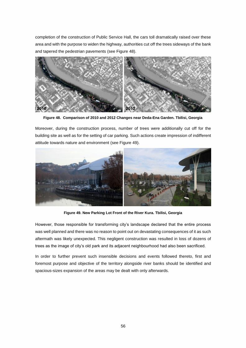
56
completion of the construction of Public Service Hall, the cars toll dramatically raised over these
area and with the purpose to widen the highway, authorities cut off the trees sideways of the bank
and tapered the pedestrian pavements (see Figure 48).
Moreover, during the construction process, number of trees were additionally cut off for the
building site as well as for the setting of car parking. Such actions create impression of indifferent
attitude towards nature and environment (see Figure 49).
However, those responsible for transforming city’s landscape declared that the entire process
was well planned and there was no reason to point out on devastating consequences of it as such
aftermath was likely unexpected. This negligent construction was resulted in loss of dozens of
trees as the image of city’s old park and its adjacent neighbourhood had also been sacrificed.
In order to further prevent such insensible decisions and events followed thereto, first and
foremost purpose and objective of the territory alongside river banks should be identified and
spacious-sizes expansion of the areas may be dealt with only afterwards.
Figure 48. Comparison of 2010 and 2012 Changes near Deda-Ena Garden. Tbilisi, Georgia
Figure 49. New Parking Lot Front of the River Kura. Tbilisi, Georgia
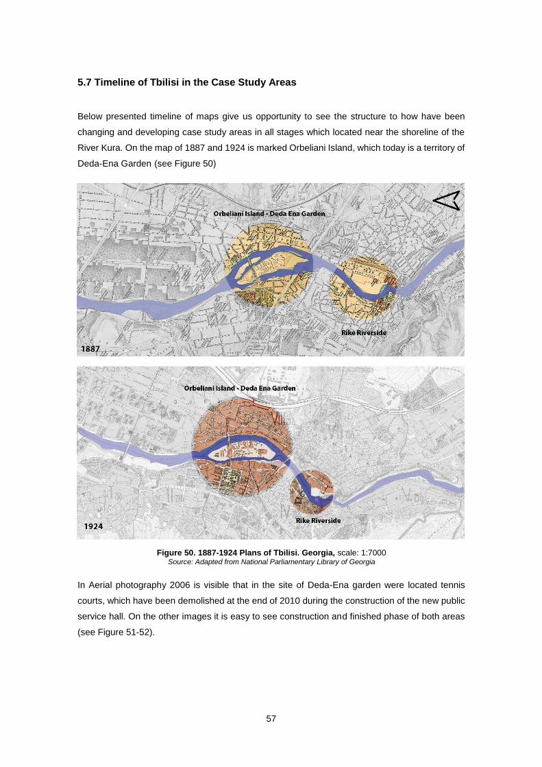
57
5.7 Timeline of Tbilisi in the Case Study Areas
Below presented timeline of maps give us opportunity to see the structure to how have been
changing and developing case study areas in all stages which located near the shoreline of the
River Kura. On the map of 1887 and 1924 is marked Orbeliani Island, which today is a territory of
Deda-Ena Garden (see Figure 50)
In Aerial photography 2006 is visible that in the site of Deda-Ena garden were located tennis
courts, which have been demolished at the end of 2010 during the construction of the new public
service hall. On the other images it is easy to see construction and finished phase of both areas
(see Figure 51-52).
Figure 50. 1887-1924 Plans of Tbilisi. Georgia, scale: 1:7000 Source: Adapted from National Parliamentary Library of Georgia
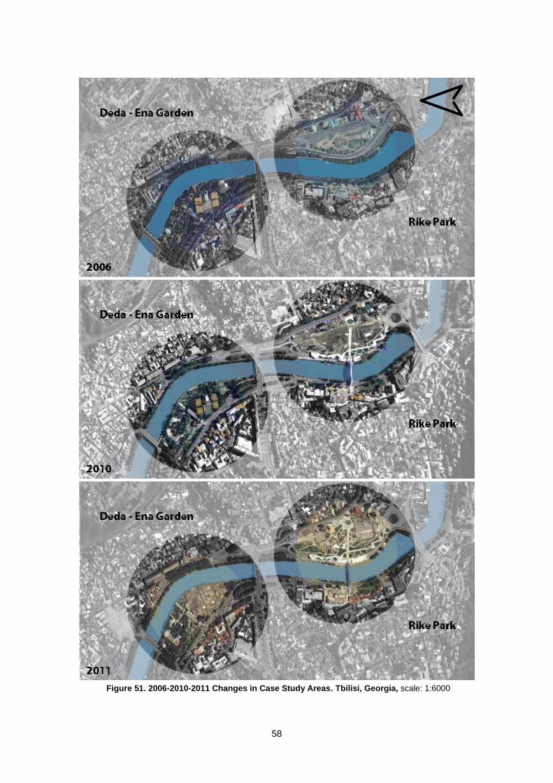
58
Figure 51. 2006-2010-2011 Changes in Case Study Areas. Tbilisi, Georgia, scale: 1:6000
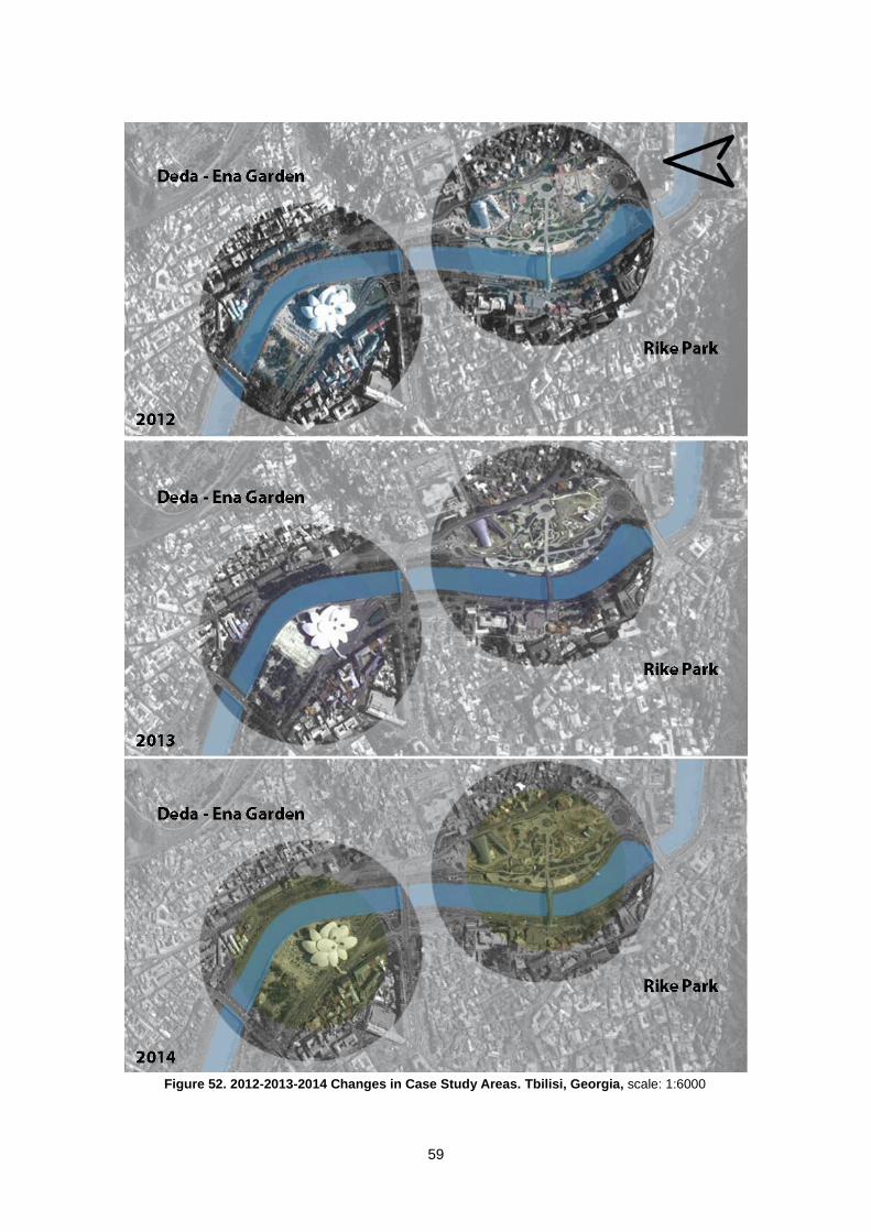
59
Figure 52. 2012-2013-2014 Changes in Case Study Areas. Tbilisi, Georgia, scale: 1:6000
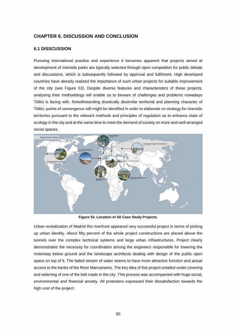
60
CHAPTER 6. DISCUSSION AND CONCLUSION
6.1 DISSCUSSION
Pursuing international practice and experience it becomes apparent that projects aimed at
development of riverside parks are typically selected through open competition for public debate
and discussions, which is subsequently followed by approval and fulfilment. High developed
countries have already realized the importance of such urban projects for suitable improvement
of the city (see Figure 53). Despite diverse features and characteristics of these projects,
analysing their methodology will enable us to beware of challenges and problems nowadays
Tbilisi is facing with. Notwithstanding drastically dissimilar territorial and planning character of
Tbilisi, points of convergence still might be identified in order to elaborate on strategy for riverside
territories pursuant to the relevant methods and principles of regulation as to enhance state of
ecology in the city and at the same time to meet the demand of society on more and well-arranged
social spaces.
Urban revitalization of Madrid Rio riverfront appeared very successful project in terms of picking
up urban identity. About fifty percent of the whole project constructions are placed above the
tunnels over the complex technical systems and large urban infrastructures. Project clearly
demonstrates the necessity for coordination among the engineers responsible for lowering the
motorway below ground and the landscape architects dealing with design of the public open
space on top of it. The faded stream of water seems to have more attractive function and actual
access to the banks of the River Manzanares. The key idea of this project entailed under covering
and widening of one of the belt roads in the city. This process was accompanied with huge social,
environmental and financial anxiety. All protesters expressed their dissatisfaction towards the
high cost of the project.
Figure 53. Location of All Case Study Projects.
61
Demarcation of major recreational facility in the city of Portland across the Harbor Drive is largely
accepted as an important happening in urban planning, because for the first time the freeway was
totally dismantled and not substituted. Establishing a waterfront park allowed the city of Portland
to foster development projects around this park, which also brought economic benefits inside the
city. Reducing of motor vehicle use caused decline of noise and air pollution in this zone.
The Paris Plage project was widely considered as a successful “urban experiment”, which
provided transformation of urban boulevard used for car traffic to the attractive and accessible
river bank, which draws lots of tourists and travelers. The idea of creating real summer beach
with imported sands, life music and activities in the middle of Paris, later turned into a worldwide
phenomenon. Development project of the Seine banks that Paris has probed highlights firstly a
method by which it establishes long-term exchange of ideas between the users, designers,
builders and the administrators who will be in charge of the installation and maintenance (see
Table 2).
This thesis mainly focuses on how conceptions of the public and public space riverfronts are being
discursively reworked today in Western Europe and also in post–socialist countries. Also
discusses altering stream of River Vistula and extension of Krymskaya embankment in Warsaw
and Moscow (see Table 3). These developments served to cause changes in public space and
the post-socialist urbanism in both cities.
These cities formed by the river, underwent through the long past of development, and reflected
the effect of the river and its renewal as their territorial development, as well as formation of
architectural planning structure and especially the nature of the riverfront construction which
changes citizen’s social-psychological relationship with river and city.
Warsaw authorities conducted reshaping program of River Vistula basin and attached utmost
importance to the development of this area. The project primarily aimed at reconstituting of the
riverfront to create recreational zone and to emerge public space, which would give the place
more attractiveness for population and tourists. The project is co-financed by the European Union,
which covered expenses for the first phase of the project, while the City of Warsaw is expected
to bear the rest of the costs related to the second stage of the work. This zone became more than
the place of rest, it is also attractive for artistic action.
The City Hall financed Krymskaya embankment project, it is important and interesting at the same
time in terms of analyzing the consequences of the closure of the site traffic. The project entailed
the risk of collapsing auto traffic situation. In general, development of waterfront spaces and parks
in Moscow is one of the key points for further improvement of the city.
Above described projects aimed at giving the places spirit of fashion, which would attract youth
and elderly people as well. Recreational zones give opportunity to both generation to enjoy
walking or taking other activities.
62
As mentioned previously, all discussed examples are unique and can’t be directly linked to the
situation in Tbilisi embankments, all these cases just share common structural pattern (see Table
4). Therefore, external experience would only serve positive developments in future regulation of
Kura banks, actually there is ample opportunity for improvement of the existing interventions, by
increasing links between the different areas and reducing the total area devoted to parking. Also
pros and cons of all these projects should be properly analyzed and only afterwards be
transposed in Georgian realm. For example: the scale of Madrid Rio project is impressive, but in
light of the current worldwide economic crisis it is completely impossible to raise funds for such a
huge project in Tbilisi, however its planning obviously suggests the ways how to tackle similar
problems. The creativeness of the Paris Plage project definitely should be acknowledged, it
stresses that re-connecting society and river may also occur even without high budget.
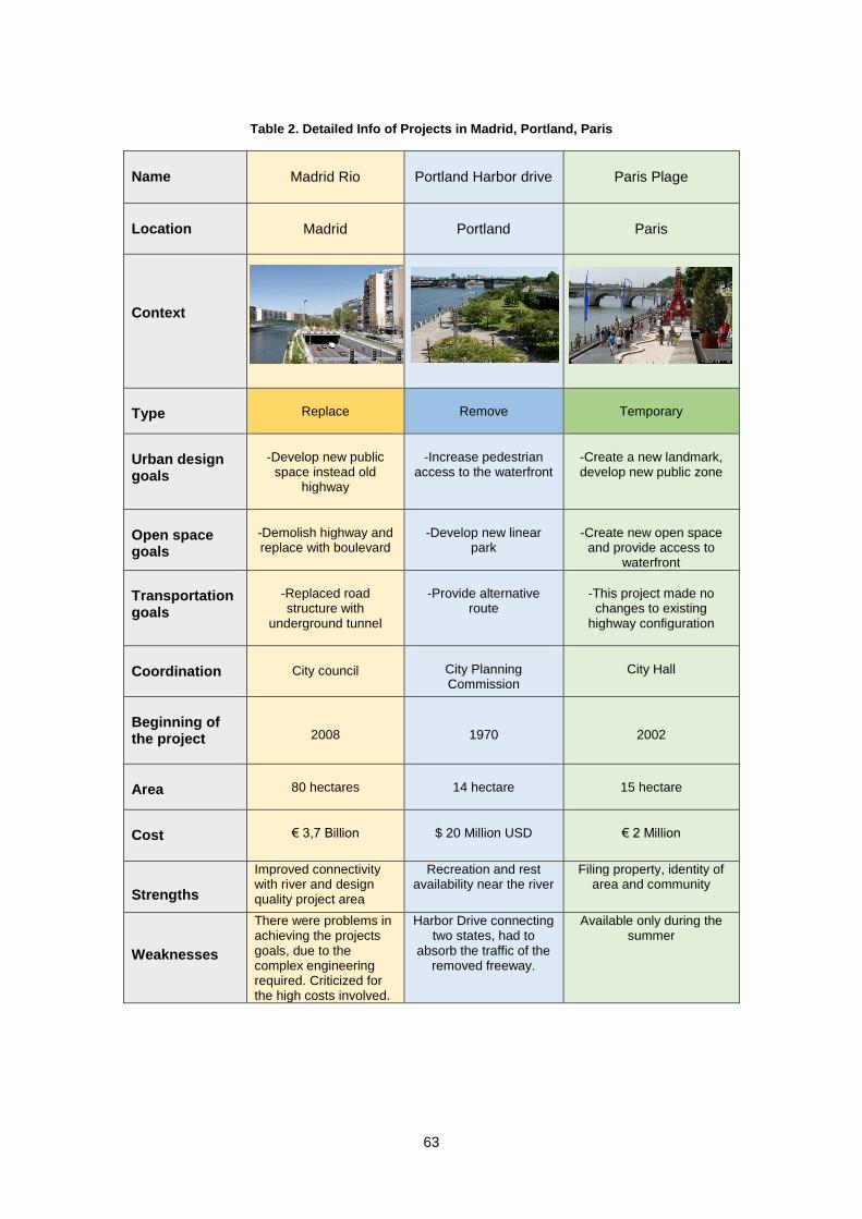
63
Table 2. Detailed Info of Projects in Madrid, Portland, Paris
Name
Madrid Rio
Portland Harbor drive
Paris Plage
Location
Madrid
Portland
Paris
Context
Type
Replace
Remove
Temporary
Urban design goals
-Develop new public
space instead old highway
-Increase pedestrian
access to the waterfront
-Create a new landmark, develop new public zone
Open space goals
-Demolish highway and replace with boulevard
-Develop new linear
park
-Create new open space
and provide access to waterfront
Transportation goals
-Replaced road structure with
underground tunnel
-Provide alternative
route
-This project made no changes to existing
highway configuration
Coordination
City council
City Planning Commission
City Hall
Beginning of the project
2008
1970
2002
Area
80 hectares
14 hectare
15 hectare
Cost
€ 3,7 Billion
$ 20 Million USD
€ 2 Million
Strengths
Improved connectivity with river and design quality project area
Recreation and rest availability near the river
Filing property, identity of area and community
Weaknesses
There were problems in achieving the projects goals, due to the complex engineering required. Criticized for the high costs involved.
Harbor Drive connecting two states, had to
absorb the traffic of the removed freeway.
Available only during the summer
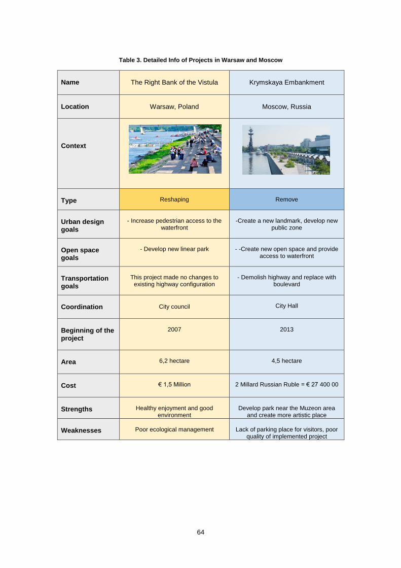
64
Table 3. Detailed Info of Projects in Warsaw and Moscow
Name
The Right Bank of the Vistula
Krymskaya Embankment
Location
Warsaw, Poland
Moscow, Russia
Context
Type
Reshaping
Remove
Urban design goals
- Increase pedestrian access to the
waterfront
-Create a new landmark, develop new
public zone
Open space goals
- Develop new linear park
- -Create new open space and provide
access to waterfront
Transportation goals
This project made no changes to
existing highway configuration
- Demolish highway and replace with
boulevard
Coordination
City council
City Hall
Beginning of the project
2007
2013
Area
6,2 hectare
4,5 hectare
Cost
€ 1,5 Million
2 Millard Russian Ruble = € 27 400 00
Strengths
Healthy enjoyment and good
environment
Develop park near the Muzeon area
and create more artistic place
Weaknesses
Poor ecological management
Lack of parking place for visitors, poor
quality of implemented project

65
Table 4. Detailed Info of Projects in Tbilisi
Name Rike Riverside Park Deda-Ena Garden
Location
Tbilisi, Georgia
Tbilisi, Georgia
Context
Type
Reshaping
Replace
Urban design goals
- Develop new Public space
-Cut down trees, demolish part of
recreational zone
Open space goals
- Create new park
-Create new public Iconic building
Transportation goals
Replaced road structure with ground
level tunnel
- Construct new overpass, make street wider and create new parking space
Coordination
City Hall
City Hall
Beginning of the project
2009
2010
Area
7,5 hectare
5 hectare
Cost
€ 2,5 Million
103 Million Georgian Lari = € 35 000 00
Strengths
New recreational area in old city
center
Modern iconic bulling
Weaknesses
Lack of access to the river, scale of new buildings too large for site.
Disappeared tennis courts, worsened traffic congestion, especially in peak
hours.
66
6.2 CONCLUSION
This paper stresses inclusion of the surrounding context to have impact on the re-programing of
the riverfront. The landscape should be ready to support existing programs for linking
neighbourhood with the riverfront. Therefore, riverfront is no more deemed as a separate faction
of the city, but constitutes integral part of larger unified arena of different such factions. Moreover,
the thesis emphasizes gradual steps on how existing land use programs might be extended and
mingled to the riverfront. Additionally, it also provides efforts in diversification of the range of uses
through letting, or even reinforcing, opportunities to renew stream circulation.
All above mentioned practical case study examples were mostly characterized with expanding
over the large programmed areas. Spaces, demarcated under these projects, with plain
accessibility to the urban fabric and the waterfront, could meet loads of cultural needs. At present,
these areas are utilized as recreational zones and places for different events. Open public spaces
are usually flexible and consequently changing urban conditions and preserve the riverfront as a
large communal storage. Best practice in this regard are exposed through the practice described
in the previous sections of this Paper. Most of the sources applied for this research, suggest that
the marginalized riverfront area might be used more effectively. Bearing in mind these ideas, new
models of riverfront for Tbilisi may have been sought. To that end, the researching this entire
project was targeted to indicating how the marginal sections along the urban riverfront can be
organized to create a more consistent riverfront, which would be better incorporated with the
community and would have a positive effect on the city’s image.
As Otto (2005) argues: “Rivers provide habitat to many plants and animals. These habitats consist
of benthic, aquatic, and terrestrial components. These three zones are the most important river
habitats that should be considered when riverfront plans and development and restoration
decisions are being made. Restoring ecological systems such as riverbanks and stream buffers
contributes for activities such as fishing, boating, swimming, and wildlife watching. Urban
riverfront planning must reconcile development, flood control, and recreation with environmental
designs and strategies that enhance the river’s ecological systems [p.151].” During the planning
process planners are obliged to take in account this aspects, which are growingly being
considered in riverside interventions in Europe, North America, and elsewhere.
Urban planning analysis of Tbilisi city and Kura River certainly implies possibility to draw
interesting conclusions and to work out all necessary steps for proper reconstruction, but notably,
keeping in bounds of only architectural planning ways of solution and, especially disregarding the
existing urban context, would serve a little purpose. Efforts should be made in drafting complex
program following inclusive discussion with and participation of various stakeholders and civil
society. Such attitude not only provides the creation of required material base, but also
significantly reinforces the esthetical image of Kura banks, functional consistency, efficiency and
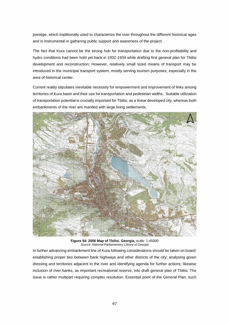
67
prestige, which traditionally used to characterize the river throughout the different historical ages
and is instrumental in gathering public support and awareness of the project.
The fact that Kura cannot be the strong hub for transportation due to the non-profitability and
hydro conditions had been hold yet back in 1932-1934 while drafting first general plan for Tbilisi
development and reconstruction; However, relatively small sized means of transport may be
introduced in the municipal transport system, mostly serving tourism purposes, especially in the
area of historical center.
Current reality stipulates inevitable necessity for empowerment and improvement of links among
territories of Kura basin and their use for transportation and pedestrian widths. Suitable utilization
of transportation potential is crucially important for Tbilisi, as a linear developed city, whereas both
embankments of the river are mantled with large living settlements.
In further advancing embankment line of Kura following considerations should be taken on board:
establishing proper ties between bank highways and other districts of the city; analysing green
dressing and territories adjacent to the river and identifying agenda for further actions; likewise
inclusion of river banks, as important recreational reserve, into draft general plan of Tbilisi. The
issue is rather multipart requiring complex resolution. Essential point of the General Plan, such
Figure 54: 2006 Map of Tbilisi. Georgia, scale: 1:45000 Source: National Parliamentary Library of Georgia
68
as functional zoning of city and transportation schemes, should be focused on own key issues as
well as on planning green social areas and consequently enhancing state of ecology in the city.
Whereas, many cities around the world spare no efforts to make large investments in establishing
high class riverfront experience for the benefit of citizens and tourists, Tbilisi is not yet ready to
take an action. A good opportunity was missed during reconstructing the Rike embankment in
Old Tbilisi. Waterfront parks requires rather different approach than other parks; riverfront areas
should be intended for people and other activities to a larger extend. Rike Park has failed to
connect with the river, the surrounding populated area lies alongside the riverfront, but lacks any
kind of bonds with the River. With a stunning rich history, currently it doesn’t fully rejoice its
heritage.
It is a pity that everything is going to be sold mainly without urban documentation. Government
as well as local government structures ignore this important (urban) constituents of the project
documents. It is supported, to some extent, by the fact that there is no spatial - territorial or
regional development contemporary planning documents of the country. Also some of the city's
land use master plan is ignored. The country does not have a comprehensive and fully-staffed
urban areas of legislation which would allow a more transparent and coordinated effort from the
planning authorities. Such large-scale constructions must be regulated in accordance with the
recognized project documentation of the urban planning. Because of the development of Georgia
the goal of which is fully, unconditional and non-alternative integration with Europe, such laws or
acts in accordance with European standards should be harmonized.
The current faded role of Tbilisi’s town planning was largely dominated by established malpractice
of investment, which is inconsistent with planning documentation and is adapted to the rapid
commercial gain. Therefore the momentum to undertake efficient legislative, institutional as well
as managerial and planning wise reform in line with European standards, peaks its crucial
importance.
69
References
Almeida, P. (2010). “ Exceptional Planning Instruments : The Polis Program in Portuguese
Cities ” Theme : Economic and Environmental Sustainability in Cities and Regions.
European Urban & Regional Studies Conference: Repostioning European Era of Global
transformation, Vienna. pp. 1-15.
Anderson, L. (1999). Transation to democracy. New York: Columbia University Press.
Andeusz, G., Harloe, M., & Szelenyi, I. (1996). Cities after socialims: urban and reginal change
and conflict in post-socialist societies. Oxford: Blackwell.
Andrusz, G. (1984). The built environment in Soviet theory and practice. International Journal of
Urban and regional Research, pp. 478-498.
Aroshidze, E. (1950). Sanapiro - Tbilisis Mshvenebaa. Komunisti, 11. (In Georgian)
Asabashvili, L. (2011, 10 08). Lived transitions. Retrieved 04 29, 2015, from
http://urbanreactor.org
Atelier Parisien D'Urbanisme. (2010). Paris, a Metropolis on the Seine. Paris Projet #40, Atelier
Parisien D'Urbanisme, pp. 140.
Balockaite, R. (2010). Post-soviet transition of the planned socialist towns: Visaginas, Lithuania.
Studies of Transition States and Societies, pp. 63-81.
Baschak, L., & Brown , R. (1995). An ecological framework for the planning, design and
management of urban river greenways. Landscape and Urban Planning, pp. 211-225.
Beridze, G. (1991). Gegmarebiti Tradiciebi XIX Saukunis Tbilisis KalaktmSheneblobashi. Kartuli
khelovneba, pp. 89-101. (In Georgian)
Bilinkin, N., & Ryabyshin, A. (1985). History of soviet Architecture of 1917-1954. Moscow:
Stroiizdat.
Bocarejo, J., LeCompte, M., & Zhou, J. (2012). The Life and Death of Urban Highways. New
York: Institute for Transportation & Development Policy and EMBARQ.
Bordas, D. (2013). Renowacja prawy brzeg Wisly, Warszawa (Poland) 2013. Retrieved 05 04,
2015, from from http://www.publicspace.org
Broadbent, G. (1990). Emerging Concepts in Urban Space Design. New York: Van Nostrand
Reinhold.
Brown, D. (2012). The Fiscal Impact of the Wilmington Riverfront. Delaware: University of
Delaware, Center for Applied Demography & Survey Research.
70
Cattel, D. (1976). Soviet cities and consumer welfera planning. In M. Hamm, The city in Russian
history. Lexington: University of Kentucky Press.
Cinis, A., Drėmaite, M., & Kalm, M. (2008). Perfect Representations of Soviet Planned Space:
Mono‐industrial towns in the Soviet Baltic Republics in the 1950s–1980s. Scandinavian
Journal of History, pp.226-246.
City Agency. (2012, 02 01). Best Practice : Large-Scale Green Space Reclamation Plan. New
York: NYC Global Partners’ Innovation Exchange.
City of Seattle. (2008, 01). Seattle Urban Mobility Plan: 6 case studies in urban freeway
removal. Seattle, Unated States. Retrieved 03 14, 2015, from http://www.seattle.gov
Corkery, N., & Hernando, E. (2012). Madrid Rio - Spain’s commitment to the public domain.
Chinese Landscape Architecture, pp. 64-67.
Czepczynski, M. (2008). Cultural landscapes of post-socialist cities: representation of powers
and needs. Hampshire: Ashgate Publishing Ltd.
Darieva, T., Kaschuba, W., & Krebs, M. (2011). Urban Spaces After Socialism: Ethnographies
of Public Places in Eurasian Cities. Campus Verlag.
De La Pradelle, M., & Lallement, E. (2004). Paris Plage: "The City is ours". The ANNALS of the
American Academy of Political and Social Science, pp. 134-145.
Dobrick, C. (2010). Madrid rio, Landscape architecture as a political means. City Regeneration,
pp. 28-35.
Domanski, B. (1997). Industrial Control over the Socialist Town: Benevolence or Exploitation.
London: Praeger.
Dyckman, J. W. (1966). Social Planning, Social Planners, and Planned Societies. Joural of the
American Institute of Planners, pp. 66-76.
Engel, B. (2007). Public space in the blue cities in Russia. In K. Stalinov, The Post-Socialist
City, Urban Form and Space Transformatons in Central and Eastern europe after
Socialism. Dordrecht: Springer, pp. 147-239.
Enyedi, G. (1996). Urbanization under socialism. In G. Andrusz, M. Harloe, & I. Szelenyi, Cities
after socialism. Urban and regional change and conflict in post-socialist societies.
Oxford: Blackwell. pp. 100-118.
European Commission (2014). Horizon 2020 in Brief. Luxemburg: Publication Office of the
European Union.
71
Faye, M., & Nelson, A. (2013). Economic impact study - Detroit riverfront. Detroit, Detroit
riverfront Concervancy.
Franchini, T., & Arana, J. (2011). The Mega-Blue-Green Network: Madrid River Project. 47th
ISOCARP Congress.
French, R., & Hamilton, F. (1979). The socialist city: Spatial structure and urban policy.
chichester: Wiley.
Gachechiladze, R. (1990). Social-geographical problems of a metropolitan region within a
Soviet republic (A case study of the Tbilisi metropolitan region, Georgia). Geoforum, pp.
475-482.
Gachechiladze, R. (1995). The new Georgia: Space, society, politics. London: UCL Press.
Gale, T. (2010). Urban Becahes as Social Installations. In S. Cole, & N. Morgan, Tourism and
Inequality, Problems and Prospects, CABI. pp. 184-185.
Gallina, N. (2010). Puzzles of state transformation. Caucasian Review of International Affairs,
pp. 20-34.
Gonzalez, R. (2006). Urban changes in different scales: Systems and structures. Univ Santiago
de Compostela.
Gorczynska, M. (2014). Unique or universal? Mechanisms and processes of social. Hungarian
Geographical Bulletin, pp. 255-270.
Grazuleviciute- Vileniske, I., & Urbonas, V. (2014). Urban regeneration in the context of post-
Soviet transformation: Lithuanian experience. Journal of Cultural Heritage, pp. 637-643.
Gventsadze, N. (2013). Tbilisis istoriulad chamokalibebuli natsilis hidrokselis kalakmaformirebeli
roli (Doctoral dissertation). Tbilisi: Georgian Technical Univesity. (In Georgian)
Hann, C. (2002). Postsocialism: Ideals, Ideologies and Practices in Eurasia. London: Routledge.
Harvey, D. (1989). The Condition of Postmodernity: An Enquiry Into the Origins of Cultural
Change. Massachusetts: Blackwell.
Hirt, S., Sellar, C., & Young, C. (2013). Neoliberal doctrine meets the Eastern Bloc: Resistance,.
Europe-Asia Studies.
Hoyle, B. (2000). Global and local change on the port-city waterfront. Geographical Review, pp.
395-417.
Jackson, L. (2006). The Public Trust Doctrine and practical Steps to Enhance Public Access.
New Jersey : New Jersey Department of Environmental Protection.

72
Janberidze, N. (1979). Kartuli Sabchota Arkitektura. Tbilisi: Khelovneba. (In Georgian)
Junker, G. (2008). Urbanismus auf Chinesisch. Dortmund: Rohn.
Kardava, D. (2013). Mtkvari da Misi Ori Napiri. Tbilisi: Bakur Sulakauri. (In Georgian)
Kashef, M. (2008). reclaming Urban Riverfronts: Creative Urban Design Intervention. Journal of
Creative Work, 1-3.
Kereimova, N. (2014, 05 09). Moscow’s Krymskaya Embankment. Retrieved 04 06, 2015, from
https://www.toposmagazine.com
Kochar, G. (1960, 04 15). Let Us Discuss Problems of City Construction. Zzvestia, (pp. 3).
Kopp, A. (1970). Town and Revolution: Soviet Architecture and City Planning, 1917-1935.
London: Thames and Hudson.
Kopp, A. (1990). Foreign Architects in the Soviet Union During the First Two Five-Year Plans. In
W. C. Brumfield, eshaping Russian Architecture: Western Technology, Utopian Dreams.
New York: Cambridge University Press. pp. 176-214.
Kornai, J., & Rose-Ackerman, S. (2004). Building a trustworthy state in post-socialist transation.
New York: Palgrave.
Krymskaya embankment / Wowhaus Architecture Bureau. (2013, 12 12). Retrieved 04 10, 2015,
from http://www.archdaily.com
Kvirkvelia, T. (1985). Arkhitektura Tbilisi. Moscow: Stroyizdat.(In Russian)
Landeiro, C., & Trigueiros, T. (2006). Increasing integration in cities by tweaking institutional
arrangements. ISoCaRP Congress.
Lang, D. (1966). The Georgians,. London: Thames & Hundson.
Law of Georgia on Water. (1997, 10 17). Tbilisi, Georgia. Retrieved 03 15, 2015, from
http://laws.codexserver.com
Lowry, T., Tidwell, V., & Rea, M. (2005). The Willamette River: A Renaissance in the Making.
Ecological riverfront design: Restoring rivers, connecting communities, pp. 135-147.
Luhmann, N. (1997). The Limits of Steering, Theory . Theory, Culture and Society, pp. 41-57.
Lynch, K. (1960). The image of the city. Cambridge: MIT press.
Machala, B. (2014). The uneven struggle for bluefields: waterfront transformation in post-
socialist Bratislava. Hungarian Geographical Bulletin, pp. 335-352.
73
Mairie De Paris. (2010, 04 14). Press pack of the Seine Embankments Project -Projet berges de
Seine-. Paris, France. Retrieved 04 01, 2015, from http://www.apur.org
Makharashvili, G. (2008). Tbilisis satskhovrebeli ganashenianebis arkitekturul-sivrtsuli
ganvitarebis principebi (Doctoral dissertation). Tbilisi: Georgian Technical University. (In
Georgian)
Manning, O. D. (1997). Design imperatives for river landscapes. Landscape Research, pp. 67-
94.
Marshall, R. (2001). Waterfronts in Post-Industrial Cities. London: Spon Press, Taylor & Francis.
McKay, D. H., & Cox, A. W. (1979). The Politics of Urban Change. London: Croom Helm.
Meskhia, S. (1959). Goroda i gorodskoi stroi feodal'noi Gruzii XII-XIII vv. Tbilisi. (In Russian)
Miller, E., & Kennedy, R. (2012). Public Realm and Transport, International best practice case
studies and opportunities for Brisbane. Brisbane: Centre for Subtropical Design
Queensland University of Technology.
Misir, T. (2015, 03 03). Moscow reconnects with its river. Retrieved 04 07, 2015, from
http://urbanland.uli.org
Nodia, G., & Scholtbach, A. (2006). The political landscape of Georgia. poltical parties,
achivements, challenges and prospects. Delft: Eburon.
Osborn, R. J., & Reiner, T. A. (1962). Soviet City Planning: Current Issues and Future
Perspectives. Journal of the American Institute of Planners, pp. 239-250.
Otto, B., McCormick, K., & Leccese, M. (2005). Ecological Riverfront Design: Restoring Rivers,
Connecting Communities. American Planning Associasion, pp. 1-170.
Pallot, B., & Shaw, D. (1981). Planning in the Soviet Union. London: Croom Helem.
Partidario, M., & Correia, F. (2004). Polis—the Portuguese programme on urban environment. A
contribution to the discussion on European Urban Policy. European Planning Studies,
pp. 409-425.
Pochkhua, M. (1999). The Link Between Town-Planning Structures and River Mtkvari in Late
Feudal Tbilisi (Doctoral dissertation). Tbilisi: Georgian technical Univesity. (In Georgian)
Portland Parks and Recretion Project Team. (2006). Waterfront Park Master Plan. Portland,
Unated States. Retrieved 03 14, 2015, from http://www.portlandoregon.gov
Preservation Institute. (2012). Removing Freeways - Restoring Cities.Paris, France Georges
Pompidou Expressway. Retrieved 04 01, 2015, from http://www.preservenet.com

74
Rigby, D., & Breen, A. (1996). The New Waterfront. London: Thames and Hudson.
Ruble, B. A. (1993). From Khrushscheby to Korobki. In W. A. Brumfield, & B. A. Ruble, Russian
Housing in the Modern Age: Design and Social History, New York: Woodrow Wilson
Center Press/ Cambridge University Press. pp. 232-270.
Salukvadze, J., & Duineveld, M. A. (2009). Would Planners be as Sweet any Other Name?
Roles in a Transitional Planning System: Tbilisi, Georgia. In K. Van Assche, & J.
Salukvadze, City culture and city planning in Tbilisi: where Europe and Asia meet
Lewiston: Edwin Mellen Press. pp. 243-303.
Service, R. (1997). A History of Twentieth-Century Russia. Cambridge: MA: Harvard University
Press.
Shavishvili , N. (2009). Decline of Public Spcae in Capitalist Georgia. In K. Van Assche , & J.
Salukvadze, City culture and city planning in Tbilisi : where Europe and Asia meet.
Lewiston: Edwin Mellen Press. pp. 209-224.
Short, J. R., Benton, L. M., Luce, W. B., & Walton, J. (1993). Reconstructing the image of the
industrial city. Annals of the Association of American Geographers, pp. 207-224.
Silva, J., Saraiva, G., Ramos, I., & Bernardo, F. (2013). Improving Visual Attractiveness to
Enhance City–River Integration—A Methodological Approach for Ongoing Evaluation.
Planning Practice & Research, pp. 163-185.
Sobiech, R., Grochowska, A., Grochowska, A., Kotuniak, A., & Bukowska-Siegel, M. (2015, 03).
Warsaw Vistula. A unique space of nature. Warsaw. Retrieved from http://urbact.eu
Stalinov, K. (2007). Urban planning and the chalanges of post-scialist transformation. In k.
Stalinov , The Post-Socilist city, Urban Form and Spcae Transformations in Central and
Eastern Europe after Socialism Dordecht: Springer. pp. 413-427.
Steavenson, W. (2004). Stories I stole. New York: Grove Press.
Suny, R. (1994). The maiking of the Georgian nation. Bloomington: Indiana University Press.
Suny, R. (2009). The Mother of Cities: Tbilisi/Tiflis in the Twilight of Empire. In K. Van Assche, &
J. Salukvadze, City culture and city planning in Tbilisi : where Europe and Asia meet
Lewiston: Edwin Mellen Press. pp. 17-55.
Svetlichnyi, B. (1960, 07 07). Soviet Town Planning Today. Problems of Economics, pp. 29-36.
Sykora, L., & Bouzarovski, S. (2012). Multiple transformations: Conceptualising the post-
communist urban transition. Urban Studies, pp. 43-60.
75
Tashman, J., & Johnson, N. (2000). An overview of urban renewal. Tashman Johnson LLC .
Consultants in Policy, Planning & Project Management, pp. 1-8.
Van Assche , K., & Salukvadze, J. (2013). Urban transformation and role transformation in the
post-Soviet metroolis. In J. J. Edward Cook, Remaking Metropolis: Global Challenges of
the Urban Landscape. Routledge.
Ward, S. V. (2012). Soviet communism and British planning movement: rational learning or
Utopian imagining? Planning Perspectives, pp. 499-524.
Weickmann, F. (2006). Riverfront Planning-Case Study of the'Chicago River Corridor
Development Plan'.
White, P. (1980). Soviet urban and regional planning. A bibliography with abstracts. New York:
St. Martin's Press.
Wiest, K. (2012). Comparative debates in post-socialist urban studies. Urban Geography, pp.
829-849.
Ziegler, K. (2006). Stadtebau in Georgien: vom sozialismus zur Martwirschaft. kaisers-lautern:
kaiserslautern University Press.(In German)
Additional Web Sources
Google Trends
http://www.idealista.com
http://www.wowhaus.ru
http://www.englishrussia.com
http://www.oginoknauss.org
http://www.urbanreactor.com
http://www.nplg.gov.ge (National Parliamentary Library of Georgia)
http://www.culture.gov.ge (Ministry of Culture and Monument Protection of Georgia)