
RESETTLEMENT PLAN THANKOT-CHAPAGAON-BHAKTAPUR 132 kV TRANSMISSION … · RESETTLEMENT PLAN...
45
RESETTLEMENT PLAN THANKOT-CHAPAGAON-BHAKTAPUR 132 kV TRANSMISSION LINE PROJECT for the RURAL ELECTRIFICATION, DISTRIBUTION AND TRANSMISSION PROJECT in NEPAL Nepal Electricity Authority May 2004 This report was prepared by the Borrower and is not an ADB document.
Transcript of RESETTLEMENT PLAN THANKOT-CHAPAGAON-BHAKTAPUR 132 kV TRANSMISSION … · RESETTLEMENT PLAN...

RESETTLEMENT PLAN
THANKOT-CHAPAGAON-BHAKTAPUR 132 kV TRANSMISSION LINE PROJECT
for the
RURAL ELECTRIFICATION, DISTRIBUTION AND TRANSMISSION PROJECT
in
NEPAL
Nepal Electricity Authority
May 2004
This report was prepared by the Borrower and is not an ADB document.

NEPAL ELECTRICITY AUTHORITY (AN UNDERTAKING OF HIS MAJESTY’S GOVERNMENT OF NEPAL)
TRANSMISSION AND SYSTEM OPERATIONS TRANSMISSION LINE/SUBSTATION CONSTRUCTION DEPARTMENT
THANKOT-CHAPAGAON-BHAKTAPUR 132 Kv TRANSMISSION LINE PROJECT
RURAL ELECTRIFICATION, DISTRIBUTION AND TRANSMISSION PROJECT
(ADB LOAN NO. 1732-NEP: (SF) & OPEC LOAN NO. 825 P)
INDEPENDENT ASSESSMENT OF
ACQUISITION, COMPENSATION, REHABILITATION PLAN (ACRP)
FINAL REPORT
Prepared by: Dr. Toran Sharma
Mr. Hari P. Bhattarai (Independent Consultants)
May 2004

Foreword The independent consultants as per the request of ADB to NEA prepare this Resettlement Plan (RP). This RP is based on the data already collected by NEA and its consultants at different times and the Environmental Impact Assessment (EIA) and ACRP with short Resettlement Plan Reports of the Transmission Line Project, approved by the concerned ministries of HMG and reviewed by ADB. The independent consultants have reviewed all the available reports in the context of ADB Guideline for Resettlement. In the process of independent assessment, the consultants made revisit of the T/L alignment and relocate house structures. Similarly, plant/vegetation and crop inventories have been prepared to assess the losses. Extensive discussion were held with the NEA officials for the development of the resettlement policy framework for the project, taking consideration of the HMG’s rules, regulations and practices and ADB policy on resettlement. The report presented is in the ADB report format and addresses the issues as per the ADB requirement. The consultants extend their gratitude to Mr. M.P. Khakurel (Project Manager), Mr. S.K. Mishra (Engineer) and Mr. P.D. Ulak (Assistant Administrative Officer) of Thankot–Chapagaon–Bhaktapur T/L project, NEA for providing all needed information and help to expedite independent assessment. Report is organized in XII Chapters and Six Annexes with an executive summary. The content of each chapter is briefly presented below: Chapter I describes the salient features of the project. Chapter II discusses on the efforts made to minimize the resettlement from the project activities. Chapter III presents the ADB and HMG policies for resettlement and describes the legal provisions of HMG including the practices of resettlement in the past and ongoing T/L projects implemented in Nepal. Resettlement policies for the proposed Thankot-Chapagaon-Bhaktapur 132 kV T/L project are briefly described. Chapter IV details the project-affected areas of the T/L project. Chapter V lists the project affected families/persons of the T/L project. Chapter VI presents the findings of the socio-economic study of the project affected communities and the project relocates. Chapter VII discusses on the socio-economic impacts of the project and mitigation measures to minimize the impacts. Chapter VIII describes the mechanism of stakeholders’ consultations and dialogues adopted for the RP preparation. Chapter X presents the institutional organization to accomplish the RP. Chapter XI presents the implementation schedule of RP. Chapter XII discusses monitoring and evaluation of RP. Chapter XIII presents the compensation/benefits to AFs/APs and RP cost estimates.

ACRONYMS
% Percentage ADB Asian Development Bank AFs Affected Families APs Affected Persons CBOs Community Base Organization CDO Chief District Officer CFC Compensation Fixation Committee DC Disturbance Compensation DDCs District Development Committees EIA Environmental Impact Assessment GI Galvanized Iron ha Hector HMG/N His Majesty’s Government of Nepal ITR Income Tax Return kg Kilogram km Kilometer kV Kilo Volt LAO Land Acquisition Officer m Meter M2 Meter Square MoPE Ministry of Population and Environment MT Metric Tonne NEA Nepal Electricity Authority NEPAP Nepal Environmental Policy and Action Plan NGOs Non-governmental Organizations Nos. Numbers NRs Nepali Rupees PM Project Manager PMO Project Management Office ROW Right of Way RP Resettlement Plan SLC School Leaving Certificate Sq. ft. Square Feet T/L Transmission Line TA Transportation Allowance VDCs Village Development Committee WECs Water and Energy Commission Secretariat

TABLE OF CONTENTS FOREWORD
ACRONYMS
TABLE OF CONTENTS
EXECUTIVE SUMMARY
CHAPTER I: THE PROJECT 1 1.1 Rationale 1 1.2 Status of Resettlement Design 1 1.3 Project Description 2
CHAPTER II: EFFORTS TO MINIMIZE RESETTLEMENT 4
2.1 Efforts in the Phase of Alignment Survey 4 2.2 Efforts Planned During Implementation 4
CHAPTER III: POLICY AND LEGAL FRAMEWORK 5
3.1 ADB Policy on Environment 5 3.2 HMG Laws and Policy 5 3.3 Resettlement Policy Framework for Thankot-Chapagaon-Bhaktapur 132kV T/L Project 9
3.3.1 Resettlement Policies 10 3.3.2 Compensation Policy for the Project 10
CHAPTER IV: THE PROJECT AFFECTED AREAS 15 CHAPTER V: AFFECTED FAMILIES/PERSONS (AFS/APS) 18 CHAPTER VI: SOCIOECONOMIC STUDY 20
6.1 Methodology 20 6.2 Results of Socio-economic Survey 20
6.2.1 Project Affected Families 20 6.2.2 Project Affected Relocatee Families 23
CHAPTER VII: SOCIOECONOMIC IMPACTS AND MITIGATING MEASURES 26 CHAPTER VIII: COMMUNITY CONSULTATION AND DIALOGUES 27
8.1 Project Stakeholders 27 8.2 Mechanisms for Stakeholders’ Participation 27
8.2.1 Dialogues/Consultation 27 8.2.2 Information Campaign 27 8.2.3 Local Government Endorsement 27
8.3 Role of NGOs and CBOs 28 CHAPTER IX: RESOLUTION OF CONFLICTS, APPEALS AND GRIEVANCE PROCEDURES 29
9.1 Setting Up a Complaint Desk 29 9.2 Procedure 29
CHAPTER X: INSTITUTIONAL ORGANIZATION 30
10.1 Organizational Linkages and Responsibilities 30 10.1.1 Project Management Office (PMO) 30 10.1.2 Account Section, PMO 30 10.1.3 Relocatees 30
10.2 Institutional Capability Building and Strengthening 30

CHAPTER XI: IMPLEMENTATION SCHEDULE 31 11.1 Relocation Schedule 31 11.2 Relation of Relocation Activities to Project Schedule 31 11.3 Procedures for RP Implementation 31 11.4 Involvement of APs, Local Government and NGOs 32
11.4.1 APs 32 11.4.2 NGOs 32 11.4.3 Local Governments 32
CHAPTER XII: MONITORING AND EVALUATION 33
12.1 Internal Monitoring 33 12.2 External Monitoring 33 12.3 Post-Relocation Evaluation 33
CHAPTER XIII: COMPENSATION/BENEFITS TO AFS/APS AND COST ESTIMATES 34
13.1 Compensation/Benefits to AFs/APs 34 13.2 Cost Estimates 35
13.2.1 Relocatee 35 13.2.2 Payments for Land Acquisition and Land Use Restriction 36 13.2.3 Payments for Crops and Trees 36 13.2.4 External Monitoring 37 13.2.5 Summary 37
REFERENCES 38 ANNEXES ANNEX IV – 1: Vegetation Inventory Report ANNEX V – 1: Land Parcel and Land Ownership ANNEX V – 2: Photographs of Affected Structures ANNEX VI – 1: Socio-economic Data Tables (Project Affiliated Families) ANNEX VI – 2: Socio-economic Data Tables (Relocatees) ANNEX X – 1: Implementation Schedule

RESETTLEMENT PLAN Thankot-Chapagaon-Bhaktapur 132 kV Transmission Line Project
EXECUTIVE SUMMARY
1. This resettlement plan (RP) has been prepared for the households affected by the Thankot-Chapagaon-Bhaktapur 132 kV Transmission Line Project, the construction sites of which are located in the districts of Kathmandu, Bhaktapur and Lalitpur. 2. The project aims to increase the power transfer capacities of transmission lines of the Kathmandu Valley in order to accommodate the planned additional power and load growth in the Valley. Additionally, it also helps enhance the reliability of power supply in the Valley. 3. The main project components, which will displace people and properties, are the construction of 132 kV overhead Transmission Line (T/L) with a total length of 28.4 km and two new sub-stations in Kathmandu and Lalitpur districts. 4. About 2,424 households residing within the T/L Right-of-Way (ROW) and substation areas will be affected which includes 1,651 landowners, 764 tenants, 6 landowners with residential structure and 3 tenants with residential structures. 5. Of the affected only 9 households require relocation. 6. House/structure owners will also be paid for the replacement cost of their houses/structures along with the associated land plots. 7. Relocatee-households will be granted an additional relocation package consisting of disturbance compensation and transportation allowance to help them resettle in new places. 8. Landowners without tenants will be paid for the land occupied permanently by the tower pads under T/L ROW and substation area at the market based prices. Loss of trees will also be paid at the market-based prices. 9. Landowners with tenant will be paid for land occupied permanently by the tower pads under T/L ROW and substation area at 50% of the market prices and remaining 50% will be paid to the tenants. Besides, tenants will also be paid for the damaged crops and plants at market-based price. 10. Landowners without tenants will be paid for the land restricted for use under T/L ROW at the 10% of market based prices. The loss of crops and trees will also be paid. 11. Landowners with tenant will be paid for land restricted for use under T/L ROW at 50% of the 10% market prices and remaining 50% of the 10% will be paid to the tenants. Besides, Tenants will also be paid for the crops and plants. 12. A third party monitoring team will be contracted by the project management office to undertake the external monitoring of RP implementation. 13. The project will provide the relocation budget estimated at NRs 136.39 million and will implement this RP with the assistance of His Majesty’s Government of Nepal.

Chapter I THE PROJECT
1.1 Rationale The Nepal Electricity Authority has undertaken the Thankot-Chapagaon-Bhaktapur 132 kV T/L Project to complete the planned 132 kV T/L ring in Kathmandu Valley which helps enhance the reliability of power supply, decreases voltage drops and energy losses and supports rural electrification of 19 Village Development Committees (VDCs) of Lalitpur district. Besides, the T/L increases the power transfer capacities of transmission system in the valley to be able to cope with the projected increase in power demand and to accommodate planned generation capacity additions. The project will require construction of about 28.4 km long 132 kV transmission line and two substations. Out of this, about 28.4 km of the length shall be new double circuit line with new ROW, whereas about 2 km of the length shall be the replacement of existing transmission line with double circuit configuration by four-circuit towers. As this 2 km long stretch utilizes the existing ROW, this Resettlement Action Plan is therefore prepared for the new construction works only. Nevertheless, since the replacing four circuit towers shall require little more land (total about 288 square meters) for foundation construction around the existing foundation, the compensation policy and modality to be followed for the new line shall be applied for this case also. The construction of T/L and substations will affect families/communities with regard to land and other properties lying within the right-of-way (ROW) of T/L and areas occupied by the substations. The Resettlement Plan (RP) has been prepared to effect the payment of compensation for the affected families/persons/communities in accordance with the ADB policy and guidelines on Resettlement /Relocation and with the following objectives:
(i) To clear houses, structures, crops, plants and trees in the areas occupied by substations and permanent structures of T/L on ROW,
(ii) To clear houses, plants and trees on newe T/L ROW limit, (iii) To restrict land use along the T/L ROW only for crops, (iv) To smoothly and effectively relocate/compensate the affected families/communities, (v) To delineate the responsibilities of various concerned agencies and the affected
families/communities in the implementation of the RP. 1.2 Status of Resettlement Design This RP is the third edition. The first edition of the RP (as mitigation measures of Socio-economic environmental impact in the EIA report) was prepared by NEA in August 2002, which was submitted to and approved by the Ministry of Population and Environment (MOPE) of His Majesty’s Government of Nepal on the same year, as per the prevailing environmental laws and regulations of HMG/N. The second edition of RP was prepared by NEA on May 2003 on the request of Asian Development Bank (ADB) to comply with its policy. ADB reviewed and commented this edition, which necessitated the preparation of this latest edition. This revised RP has been prepared to accommodate the comments of ADB dated 07.02.2003. Payment of compensation and resettlement of affected families/communities within the substation sites shall be completed before construction works commence. And, as locating the precise area of ROW follows only after the finalization of the check survey and tower spotting by the contractors, the payment for T/L shall commence immediately after these activities. The data presented herein is based on cross-verification and updating of field research and household surveys and interviews conducted by the NEA project office through Soil, Rock and Concrete Laboratory of NEA.
2
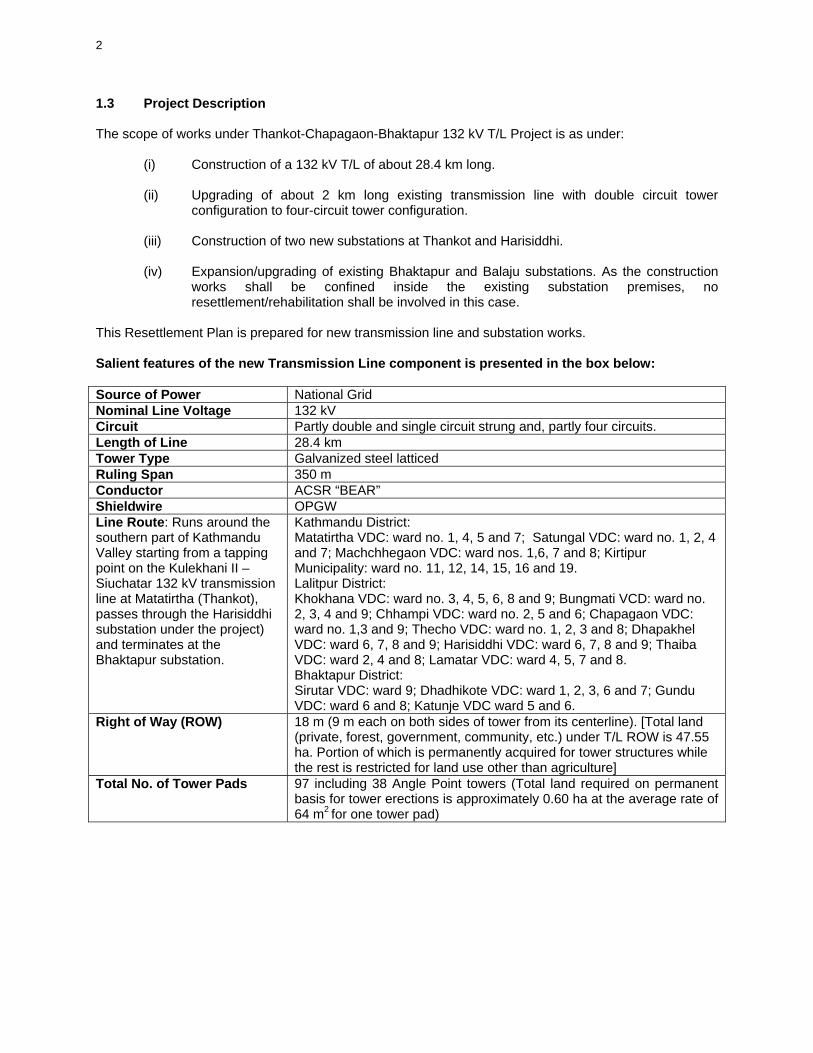
1.3 Project Description The scope of works under Thankot-Chapagaon-Bhaktapur 132 kV T/L Project is as under:
(i) Construction of a 132 kV T/L of about 28.4 km long. (ii) Upgrading of about 2 km long existing transmission line with double circuit tower
configuration to four-circuit tower configuration. (iii) Construction of two new substations at Thankot and Harisiddhi. (iv) Expansion/upgrading of existing Bhaktapur and Balaju substations. As the construction
works shall be confined inside the existing substation premises, no resettlement/rehabilitation shall be involved in this case.
This Resettlement Plan is prepared for new transmission line and substation works. Salient features of the new Transmission Line component is presented in the box below: Source of Power National Grid Nominal Line Voltage 132 kV Circuit Partly double and single circuit strung and, partly four circuits. Length of Line 28.4 km Tower Type Galvanized steel latticed Ruling Span 350 m Conductor ACSR “BEAR” Shieldwire OPGW Line Route: Runs around the southern part of Kathmandu Valley starting from a tapping point on the Kulekhani II – Siuchatar 132 kV transmission line at Matatirtha (Thankot), passes through the Harisiddhi substation under the project) and terminates at the Bhaktapur substation.
Kathmandu District: Matatirtha VDC: ward no. 1, 4, 5 and 7; Satungal VDC: ward no. 1, 2, 4 and 7; Machchhegaon VDC: ward nos. 1,6, 7 and 8; Kirtipur Municipality: ward no. 11, 12, 14, 15, 16 and 19. Lalitpur District: Khokhana VDC: ward no. 3, 4, 5, 6, 8 and 9; Bungmati VCD: ward no. 2, 3, 4 and 9; Chhampi VDC: ward no. 2, 5 and 6; Chapagaon VDC: ward no. 1,3 and 9; Thecho VDC: ward no. 1, 2, 3 and 8; Dhapakhel VDC: ward 6, 7, 8 and 9; Harisiddhi VDC: ward 6, 7, 8 and 9; Thaiba VDC: ward 2, 4 and 8; Lamatar VDC: ward 4, 5, 7 and 8. Bhaktapur District: Sirutar VDC: ward 9; Dhadhikote VDC: ward 1, 2, 3, 6 and 7; Gundu VDC: ward 6 and 8; Katunje VDC ward 5 and 6.
Right of Way (ROW) 18 m (9 m each on both sides of tower from its centerline). [Total land (private, forest, government, community, etc.) under T/L ROW is 47.55 ha. Portion of which is permanently acquired for tower structures while the rest is restricted for land use other than agriculture]
Total No. of Tower Pads 97 including 38 Angle Point towers (Total land required on permanent basis for tower erections is approximately 0.60 ha at the average rate of 64 m2 for one tower pad)

3
Salient Features of New Substation Components are as under: Substations Key Features
Three 132 kV line bays One bus coupler bay Switching station control building
132 kV Matatirtha switching station with double bus bar scheme
Total land required – 2.33 has. Two 132 kV line bays One bus coupler One 132 kV transformer bay 1 x 22.5 MVA, 132/11 kV power transformer 7 nos of 11 kV switchgears Substation control building
132/11 kV Harishiddhi substation double bus bar scheme (currently one bus bar only with the provision for second one in future)
Total land required = 1.48 has. The project will be funded jointly by the Asian Development Bank, OPEC fund (to be administered by the ADB), HMG/N and NEA. ADB requires the preparation of this resettlement plan in conformity with its policy on involuntary resettlement. An Environmental Impact Assessment (EIA) approval has already been obtained for the project from the Ministry of Population and Environment of His Majesty’s Government of Nepal.

4
Chapter II EFFORTS TO MINIMISE RESETTLEMENT
2.1 Efforts in the Phase of Alignment Survey Alignment survey in the pre-feasibility, feasibility and detail design stages have avoided displacement of people as far as practicable by exploring alternative realignment of the T/L. Settlement areas and the residential/community structures were avoided wherever possible to minimize the relocation and displacement The efforts made have minimized relocation of people and community facilities also. During feasibility stage a total number of 12 households' structures were identified for relocation. Realignment of the T/L in the detail design stage avoided 3 household structures from relocation. The substation sites have been selected in areas away from settlement with no residential or community structures so as to avoid relocation. Despite the efforts, some structures and productive land could not be avoided. This RP is prepared to execute resettlement as a development initiative, which provides displaced or affected households/person/communities with opportunities to participate in the planning and to restore and improve their livelihood. 2.2 Efforts Planned During Implementation The project office is aware of the gravity of the impacts to the affected people and has put due emphasis to avoid environmental impacts as far as possible during construction phase. Tender Document has provisions to minimize the loss of standing crops/trees while stringing the conductors.

5
Chapter III POLICY AND LEGAL FRAMEWORK
3.1 ADB Policy on Resettlement The ADB policy on resettlement rests on the following principles:
• Involuntary resettlement should be minimized by exploring all viable project options. • Affected families/persons should be fully informed and consulted. • A resettlement plan should be prepared for those to be displaced. • Affected families/persons should receive compensation at replacement rates for all losses and
damaged assets. The absence of legal titles to lands should not be a bar to for compensation. • Affected families have to be fully compensated and resettled before their houses are demolished
and their land is acquired by the project. • Involuntary resettlement should be conceived and executed as a development project.
The resettlement plan implementation has to be monitored by the project implementer and the ADB. 3.2 HMG Laws and Policy Nepal has a long history of voluntary resettlement. But there is not a clear and comprehensive policy on the resettlement of project displaced families. Till now, different development projects have been implementing involuntary resettlement, compensation and rehabilitation activities on the basis of specific circumstances without the framework of a coherent policy. Existing legal provisions of the country on land acquisition, compensation and rehabilitation also are not sufficient enough to address the needs of the project-displaced people. Table below provides a brief account of the existing policies and legal framework, which focus on description and also limitations and constraints of these with respect to forming a national policy.
Key Policy/La/Regulations of Nepal
Policy/Law/Regulation Responsible Authority
Applications
The constitution of the Kingdom of Nepal (1990) Article 17 His Majesty’s
Government Establishes the right of individual’s property as a fundamental right. But private property could be acquired for public interest by compensating the losses of property, following the procedures on delivering compensation for any property, as prescribed by Laws (The applicable Act is Land Acquisition Act, 1977)
Hydropower Development Policy (1992 and 2001) Policy Document Ministry of Water
Resources Focuses on conservation of the environment while developing hydropower, transmission and distribution projects. It further mentions that it is the project developer’s obligation to relocate and resettle the families being displaced by the project, as per the standards set by the Government.
Nepal Environmental Policy and Action Plan (NEPAP) 1993 Policy Document His Majesty’s
Government NEPAP emphasized the need for mitigating adverse environmental impacts to address urban and industrial development, air and water pollution and infrastructure development.
Land Acquisition Act 1977 as amended in 1992 Section 3 & 4 His Majesty’s
Government Right of HMG/N to acquire or cause to acquire any land – subject to compensation under this law – for public interest and for institutions/organization.
Section 5 & 6 Land Acquisition Officer
After obtaining permission for land acquisition, the LAO shall be responsible to identify, survey, notification to the concerned parties and other works related to acquisition.

6
Policy/Law/Regulation Responsible Authority
Applications
Section 7 Land Acquisition Officer/Chief District Officer (CDO)
The LAO shall determine the amount of compensation for the damaged property (house, wall, trees, etc.) while conducting initial survey works. In case the concerned person is not satisfied with the amount of compensation determined, he may file the complaint to the CDO within 15 days and CDO’s decision shall be final.
Section 8 Land Acquisition Officer
Within 15 days of the preliminary activities the LAO has confirmed the required land and submit the other details of the required property to the CDO. The details shall also include complete account of the losses and associated compensation amount as per clause 7.
Section 9 Chief District Officer/land revenue officer
Empowers CDO for public notification, with details of the affected property after receiving the report of preliminary activities from the LAO. The notification with required details is to be published in the notice boards of Project Site Office, District Development Office, Concerned Village Development Office or Municipality Office, Land Administration Office, Land Revenue Office, or any place close to the land and property acquisition sites. And, if the CDO feels that any concerned party might not be informed by the public notice, then he may inform him/her personally with other details. Land Revenue office is mandated to stop registration of the notified and property till further notice by the CDO.
Section 10 Chief District Officer Describes the facts to be included in the public notice of clause 9 such as: the documents required and the time to apply for the compensation; the time period within which the standing crops, structures, etc. could be managed by the concerned party, etc.
Section 11 Home Ministry, His Majesty’s Government
Any grievance to disable land and property acquisition could be reported to Home Ministry within 7 days of public notification by CDO. Home Ministry is required to decide on the grievances within 15 days of the receipt of grievances. On deciding the grievances, home ministry is authorized in as much capacity as the district court to consult the local authority or, ask for necessary documents or, consult witnesses.
Section 12 CDO After the expiry of the grievance period or after the decision on grievances whichever is earlier, CDO can hold the land for acquisition for the purpose of project implementation and give to the project office or the concerned organization. Notwithstanding the above, if the land acquired has a built-house structure and is being occupied by the owner, then, at least 50% of the compensation amount shall be paid before acquisition, provided the compensation is decided; if not, the owner shall be given reasonable amount as advance payment required for relocation.
Section 13 Compensation Fixation Committee
A compensation fixation committee comprising of Chief District Officer, Land Administrator or Land Revenue Officer, Project Manager and Representative of District Development Committee decides upon the compensation amount of land and property. The compensation decided will be based on cash compensation. Furthermore, separate compensation rates could be fixed for the cases of – whole and a part – of the land being owned by a person is acquired.
Section 14 HMG/Compensation Fixation Committee
On request from the concerned party, land to land compensation could be given provided HMG has such land on its ownership.
Section 16 Compensation Fixation Committee
Following considerations shall be made while deciding compensation of the land and property to be acquired for HMG or institutions with full HMG ownership • Guidelines of HMG

7
Policy/Law/Regulation Responsible Authority
Applications
• Losses incurred by concerned party because of the relocation of his settlement or place of business.
• For land and property acquisition for the institution other than HMG undertakings.
• Market price of the land at the time of notification. • Losses incurred by the concerned party because of the
relocation of his settlement or place of business. • Price of land with residential structures and standing
agricultural products Section 18 CDO Provision for information to the concerned parties regarding the
list of the persons being compensated. Section 19 CDO States that after the compensation fixation committee decides
on the compensation, this shall be notified to HMG/N by the CDO.
Section 20 CDO Legal tenants of the land are entitled for 25% of compensation amount of the acquired land. If the tenant has built house also with the consent of the landowner, then he shall be entitled for full compensation of such house.
Section 21 CDO Unpaid government taxes, if any, could be deducted from the compensation amount.
Section 22 & 23 CDO Transfer of ownership of land and property to the name of HMG or institution for which the land and property has been acquired. The CDO shall notify the local land revenue office for such transfer within 15 days of acquisition.
Section 29 CDO If the concerned party requests that the land be acquired along with the existing houses, wall, standing crops, trees, etc. complete, then the acquisition process shall consider this also.
Section 30 HMG/N The government may decide not to acquire any land for any reason, which was initially put in the process of acquisition. This is subject to the concerned party’s information. Nevertheless, the losses incurred during the preliminary activities of land acquisition shall be compensated as described in clause 7.
Section 33 HMG The land acquired for the specified purpose shall be used for that purpose only.
Section 34 & 35 HMG If the acquired land is not used for the specified purpose, it has to be returned to the land and property owners only in condition that the owner pays back the compensation amount paid. If the owner is not willing to take back the land and property or, he could not be traced, it could be sold to third party.
Section 37 CDO The concerned party should take the compensation amount within specified time. If not, the affected person shall be notified by CDO giving 3 months time. Failing to meet the given time, the concerned party shall not be paid the compensation amount. And, such amount shall be deposited in the Government’s reserve fund.
Section 39 CDO Any obstruction in the execution of the provisions of the clause 6 of the Act shall be fined and penalized.
Section 40 Appeal Court Preliminary hearing of grievances/cases related to the Act shall be done by the CDO. Appeal to such hearing could be made to the Appellate Court within 35 days. The decision of the CDO could be filed to the Appellate Court within 35 days.
Land Reform Act 1964 (2021) as amended 1997 (2053/9/24) Section 25 HMG Sets the ownership rights to the actual tiller on the land. Section 26 HMG Sets 50% ownership right to the tenant. Tenants have
prerogative right on the structures and access in the land property.
Land Revenue Act 1977 (2034) Section 8 HMG Registration, change of ownership, termination of ownership
right and maintenance of land records are done by local Land

8
Policy/Law/Regulation Responsible Authority
Applications
Revenue (Malpot) Office Section 16 HMG If the concerned owner did not pay land revenue for long period
of time the government can collect revenue through auction of the concerned parcel.
Water Resources Act 1992 (2049) Section 16 HMG States that if private land has to be used in order to utilize water
resources, the licensed person can request the government to acquire the land through standard procedures (Land Acquisition Act, 1977). The transmission Line Project is considered as water resource development project.
Electricity Act 1992 (2049) Section 33 HMG States that if private land ahs to be used in order to utilize for
water resource development including electricity generation, transmission and distribution, the licensed person can request the government; and the government could require the land through standard procedures (Land Acquisition Act, 1977) as it does for organized institutions. States further that HMG can restrict land use in and around the electricity infrastructure such as generation, transmission and distribution being developed by HMG or a licensed person. However, HMG or licensed person will have to compensate the concerned parties for the losses incurred due to restriction of the land use through the standard procedures (Land Acquisition Act, 1977).
Electricity Rule 1993 (2050) Rule 66 HMG Empowers the government to prohibit use of land places of
generation, transmission or distribution infrastructures or, other structures, for other specific purposes in and around them through publication of public notice in HMG gazette from time to time. It further states that no building construction or tree plantation is allowed within the specified limit in and around the electricity transmission and distribution lines.
Rule 87 HMG or licensed person/institution
States that the land and property owners of acquired or restricted property shall be paid, full compensation amount as determined by the compensation fixation committee as per clause 88.
Rule 88 HMG A compensation fixation committee under the chairmanship of HMG-appointed person, concerned person or the representative of the project, an expert appointed by HMG in the field of electricity, fixed-property owner or his/her representative, representative of the Land Revenue Office, representative of the concerned Village Development Committee/Municipality shall decide the compensation of the affected land and property. Compensation shall be based on the actual loss of the land and property.
Note: LAO = Land Acquisition Officer: An officer deputed by HMG/N for the preliminary activities related to the land acquisition. CDO = Chief District Officer: An Officer responsible for district administration and security. The Concerned Party: Any person or organization being affected because of the acquisition of the land being owned by him/her or it, and who shall be entitled for the compensation for such land. Despite limitations, Land Acquisition Act 2034 (1977) and Electricity Regulations, 1993 are the main legislation to guide land acquisition/restriction in Nepal. Water and Energy Commission Secretariat (WECS) is currently taking initiative for the Amendment of Land Acquisition Act 2034 with technical assistance of ADB. It is likely to take some time.

9
Thus, based on the limitations in the existing legal framework, a project-specific policy for Thankot-Chapagaon-Bhaktapure 132 kV T/L Project is developed based on the best past practices of NEA transmission line projects below and in conformity with ADB policy on resettlement.
Key Project Specific Policy in T/L Projects in Nepal
Project Policy Transmission Line Projects prior to 1993
Compensation in cash to the legal APs (owners and tenants) only for house structures under ROW and land occupied by Tower structures as per Land Acquisition Act 1977. No compensation to other land restricted for land use under ROW. No resettlement provisions. No provisions for rehabilitation and livelihood assistance to APs. No provisions for compensation to the trees and standing crops. No provision of compensation and rehabilitation/livelihood assistance to APs other than legal titleholders.
Kathmandu Valley High Voltage Reinforcement Project (1993-1997), financed under World Bank’s loan assistance.
Inclusion of representatives of the APs and village development committees in the Compensation Fixation Committee. 100% cash compensation to legal APs for the land occupied by the permanent structures. The land is registered to NEA. 10% cash compensation to the legal APs for the land use restriction on ROW. The land ownership remains to APs. 100% cash compensation to the legal APs for the house structure under ROW and 90% cash compensation to the land occupied by house structure. The land is restricted for structure and tree plantation. The land ownership remains to APs. 100% cash compensation to planted trees, fruit trees and crops. Cash compensation for land is based on the market price of the land. Cash compensation for house structure is based on the district evaluation norms. Depreciation was accounted. Cash compensation for trees and crops based on the District Forest Officer’s evaluation. The structure owner was entitled for salvaged materials. Additional 10% of the structure cost was compensated in cash to APs for the transportation of salvaged material.
Khimti-Bhaktapur-Balaju 132 kV Transmission Line Project (1995-1999), financed under the Finnish grant and Nordic Development Fund loan.
All provisions similar to Kathmandu Valley Reinforcement Project (1993-1997) with following instructions: 100% cash compensation for utility facilities such as water supply, power supply, telephone, toilets, bio-gas plant and cowsheds to legal APs of house structure on ROW.
Lalpur-Gaddahcauki 132 kV Transmission Line Project (1997-1999), under NEA & HMGN finance.
All provisions similar to Khimti-Bhaktapur-Balaju 132 kV Transmission Line Project (1995-1999) with following additions. Rental costs in cash to legal APs of the house structures on ROW for a period of 6 months.
Chilime-Trishuli-Devighat 66 kV Transmission Line Project (1997-1999) under NEA & HMGN finance.
All provisions similar to Khimti-Bhaktapur-Balaju 1323 kV Transmission Line Project (1995-1999).
Lower Marsyangdi-Middle Marsyangdi 132 kV T/L Project (Proposed for construction under NEA& KfW financing.
All provisions similar to Khimti-Bhaktapur-Balaju 1323 kV Transmission Line Project (1995-1999).
3.3 Resettlement Policy Framework for Thankot- Chapagaon – Bhaktapur 132 kV T/L Project To execute the Resettlement and Rehabilitation of the APs of Thankot- Chapagaon - Bhaktapur 132 kV T/L Project following policies together with the Entitlement Matrix will be complied.
10
3.3.1 Resettlement Policies The resettlement activities to be pursued by of the project will be guided by the following basic policies:
• Land acquisition and involuntary resettlement shall be avoided where feasible or minimized to the extent possible through the incorporation of social considerations into project design options.
• Where population displacement is unavoidable, individuals, households and community losing assets, livelihood and other resources shall be informed and consulted.
• APs shall be compensated at replacement rates for all losses and damaged assets. The absence of legal titles to lands, property, and facilities shall not be a bar to compensation.
• APs shall be fully compensated and resettled before their houses are demolished and their land and facilities are acquired.
• A resettlement plan shall be prepared and consulted with APs in advance of the implementation of the project.
• The resettlement plan implementation shall be monitored. • The resettlement shall be executed as part of the development project. • After RP implementation, the economic and social conditions of the APs should be improved or at
least maintained. 3.3.2 Compensation Policy for the Project The following compensation policies are part of the overall policy on resettlement/relocation. The Land Acquisition Act 1977, Electricity Act 1992 and Electricity Regulation (1993) will be the key legal procedures that shall be followed for the compensation determination and payments. 3.3.2.1 Compensation and Benefits
1. The permanent loss of land (agricultural, residential, commercial and forestry)
(i) APs whose land (agricultural, residential, commercial and forestry) will be acquired permanently for T/L structure or substation, the land shall be paid at replacement rate based on the valuation of lands by the Compensation Fixation Committee. Such land parcel registration shall be transferred to NEA.
(ii) If the remaining land parcel after permanent acquisition is too small (i.e. less than 64 square meter) and the APs does not own adjoining plot and is willing to dispose the land, the entire plot shall be acquired at the replacement cost.
2. Restriction on land use.
APs whose land (agricultural, residential, commercial and forestry) will be restricted for development of structures and forestry, the land shall be paid at 10% of replacement rate based on the valuation of lands by the Compensation Fixation Committee. Such land parcel registration will remain with APs.
3. The loss of crop and other natural resources
Crops/plants and trees/natural resources that will be damaged during project construction shall be compensated to APs based on the current fair market value determined by District Forest Office, District Agriculture Office or other government agencies.
4. The loss of houses and other structures including utility facilities
Houses and other structures including utility facilities (electricity, telephone, water supply, toilets, bio-gas plants etc.) shall be compensated based on their replacement cost which is the cost of

11
materials and labor in the locality or as evaluated by the district norms at the time of relocation. No depreciation shall be applied. Additionally, the associated land plots of the houses as estimated in this study shall be provided. The house owners/structure owners shall be responsible for dismantling the affected house/structure and shall own salvageable materials.
5. The loss of community facilities and resources
(i) The project affected community facilities (such as schools, temples, health posts, water
points, irrigation canals, footbridges, graves and ghats (a ghat ;s a Hindu cremation place which is a small and open platform-like structure at river bank) shall be compensated at replacement cost or restored to their previous condition or replaced in areas identified in consultation with affected communities and the relevant authorities.
(ii) The loss of resources such as community forests and religious forests shall be compensated in consultation with Community Forestry User groups and Religious Organizations.
6. The loss of government property
(i) Government infrastructure and facilities including utilities affected by the project shall be
repaired or replaced or compensated at replacement costs in consultation with the relevant departmental authorities.
(ii) Government forest areas shall be acquired in consultation with the Department of Forestry and any loss of trees therein shall be compensated as per the government rules.
7. Grant of disturbance compensation (DC)
Disturbance compensation in the amount not exceeding of NRs. 21000 will be given to each displaced family or amount equivalent to the daily minimum wage in the project-affected area multiplied by 150 days whichever is lower. This grant shall be used to defray the affected households daily expenses while adjusting to their new environment.
8. Transportation allowance (TA) to displaced households
For APs of acquired house structure, an additional Transport allowance of NRs. 15000 as a grant shall be paid to cover the transportation of the salvaged materials.
9. Compensation for business losses
Compensation for business losses in amount up to NRs 30000 will be paid or based on daily income which ever is lower, as reflected on income tax return (ITR) multiplied by the number of days of business stoppage due to the project, but in no case shall it be more than 90 days.
3.3.2.2 Valuation Process
Valuation of land and other property shall follow the HMG Acts and Regulations and the ADS resettlement policy.
1. Valuation of land
Valuation of the land on ROW and Substation will be made by the Compensation Fixation Committee as per section 13 of the Land Acquisition Act 1977. The composition of the Compensation Fixation Committee members will be as per Rule 88 of Electricity Rules. The land evaluation cost shall be based on the replacement cost. Consideration to residential, urban, and rural agricultural land shall be taken while evaluating the land replacement cost of the affected areas.

12
2. Valuation of house and other structures and utilities
Decisions on the valuation of house and other structures and utilities by Compensation Fixation Committee shall be based on the valuation norms of the District Development Committee or valuation made by District Office of Housing. Depreciation shall not be included in the valuation.
3. Valuation of trees and biomass
Decisions on the valuation of trees and biomass by Compensation Fixation Committee shall be based on the valuation norms of the District Forest Office or Valuation made by the officers of District Forest Office.
4. Valuation of damaged crops and agriculture produce
Decision on the valuation of damaged crops and agriculture produce by the Compensation Fixation Committee shall be based on the valuation norms of the District Agriculture Office or Valuation made by the officers of District Agricultural Office. Valuation shall be made to the actual damage of the crops and agriculture produce.
3.3.2.3 Participation of Affected and Displaced Families
The affected and displaced families shall be informed and consulted during the pre-relocation activities on compensation package and procedures for payment and settlement of conflicts/disagreements. They will also be regularly informed and consulted during RP implementation. Requests for meeting/consultations with Compensation Fixation Committee to resolve related issues/concerns could be coursed through the Project Management Office (PMO).
3.3.2.4 Entitlement/Eligibility of Affected Households/Persons
The following APs, communities and Government agencies as defined are eligible for payment of compensation as provided in the RP:
(i) Landowner - A person who owns land/s within the project-affected areas with legal
ownership documents. In some exceptional cases, a person who owns land/s within the project-affected areas regardless of proof of such ownership will also be entitled. However, special decisions by the concerned Governmental agency shall be made taking into account the local government/community's recommendation also.
(ii) Land tenant - A person who works on a project-affected land owned by another person
with a legal proof from Land Revenue Office. (iii) Structure owner - A person who owns a project-affected building/structure including a
dwelling unit but resides in an area not affected by the project. (iv) Business owner - A person who owns or conduct a business within the project-affected
area, the operation of which will be disrupted by the construction of the project. (v) Community - A community who owns project affected building structures or resources
and utilize buildings or resources of the affected areas. (vi) Government Agency - A government agency that owns project affected building
structures or resources and utilizes buildings and resources of the affected areas.

13
(vii) Relocatees - APs who are actually residing in the affected areas at the time of the conduct of socioeconomic survey and have to move their residences as a result of project construction. The different types of relocatees are:
a. House and Lot owner - a person/family who owns and actually occupies an
affected house and lot.
b. House owner tenant - a person/family who owns and actually occupies a project-affected house with or without the consent of the lot owner.
c. Informal Settler - a person/family who owns and actually occupies a project- affected house located on a government land or on a private land but without the consent of the owner.
d. House occupant - a person or family who occupies an affected house either as an occupant free of charge or on rent.
The matrix in the table below shows the basic compensation each AF/AP, communities and Government agencies will receive. 3.3.2.5 Cut-Off Date/Non-Eligibility for Compensation The validation of APs based on the parcellary and house-to-house surveys of the T/L ROW was completed on April 2003. Accordingly, Ministry of Water Resources published a public notification pursuant to the Electricity Act 1992 section 33.3 and Electricity Regulation, Rule 66. 1 in the Nepal Gazette on 26th of May 2003 as cut off date for the Project compensation and benefits to APs. Households or persons who will introduce new houses/structures at the project affected areas after the cut-off date will be considered non-eligible households/persons and therefore will neither be compensated for their properties nor will be granted relocation benefits. Land required for substation/switching station areas are already acquired as per prevailing rules and in consensus with the people concerned in compliance to this proposed RP. Payment of compensation amount to the concerned landowners of the planned Matatirtha switching station is already over on February 2004. As a rule, the compensation amount of all the concerned landowners of the planned Harisiddhi substation is deposited to the relevant Government office (District Administration Office) and the payment of that is being made from that office.

14
Entitlement Matrix for the project APs
Types of APs
Types of Compensation/Rehabilitation
Permanent loss of land at replacement cost
Restriction on land use 10% of replacement cost
Loss of crops and Natural resources
Loss of House and other structures at replacement cost
Loss of community facilities and resources
Loss of government property
Grant for disturbance compensation to displaced households
Grant of Transportation allowance to displaced households
Loss of Business
Landowner X X X Land tenant X X X Structure owner
X
Business owner
X
Community X Government Agency
X
Relocatees House and Lot owner
X X X X X X
House owner tenant
X X X X X X
Informal Settler
X X X
House occupant
X X
Note: Compensation to land (permanent or land use restriction) with tenant shall be halved between the owner and tenant as per Land Reform Act provisions. The loss of crops and natural resources on such land however shall be paid to the tenant only.

15
Chapter IV THE PROJECT-AFFECTED AREAS
The Transmission Line and the Sub-station components affect the land and property under different land ownership categories. The Districts and Village Development Committees affected by the T/L and sub-stations are as follows:
T/L components
District Village Development Committee
Ward Nos.
Kathmandu Matatirtha 1, 4, 5, 7 Satungal 1, 2, 4, 7 Machchhegaon 1, 6, 7, 8 Bahirigaon* 9 Balkumari* 3, 4, 6, 8, 9 Chovar* 5, 9 Lalitpur Khokana 3, 4, 5, 6, 8, 9 Bungmati 2, 3, 4, 9 Chhampi 2, 5, 6 Thecho 1, 2, 3, 8 Chapagaon 1, 3, 9 Dhapakhel 6, 7, 8, 9 Thaiba 9 Harisidhi 6, 7, 8, 9 Sanagaon 4, 5, 6, 7 Luvu 2, 4, 8 Lamatar 4, 5, 7, 8 Bhaktapur Sirutar 9 Dadhikot 1, 2, 3, 6, 7 Gundu 6, 8 Katunje 5, 6 Sub-stations Matatirtha Kathmandu Matatirtha 4 Harisiddhi Lalitpur Harisiddhi 4 * These are the VDCs as per original record in the Land Revenue Office. These have now been transformed into the units of Kirtipur Municipality and accordingly they are no reorganized and recognized as ward numbers 11, 12, 14, 15, 16 and 19 of this Municipality. Most of the affected areas are agricultural lands planted to rice, wheat, corn, and diverse types of seasonal vegetables with various plants/trees. Below are the impact figures on affected land area. A. Total Land Area Affected
Land Affected (ha) Component Total Length of T/L (km)
T/L ROW (meter) Permanent
acquisition (a) Land use
restriction (b)
Total Land Affected (a+b)
(ha) T/L New 26.4 0.57 46.95 Replacement by 4-circuit line
2
18
0.029*1 0*2
47.55
Matatirtha Sub-station
2.33 0 2.33
Harisiddhi Substation
1.48 0 1.48
Total Land Affected
28.4 4.41 46.95 51.36
Note = *1 – additional land for 8 tower pads, *2 – land already acquired at 10% of the replacement cost on 1996
16
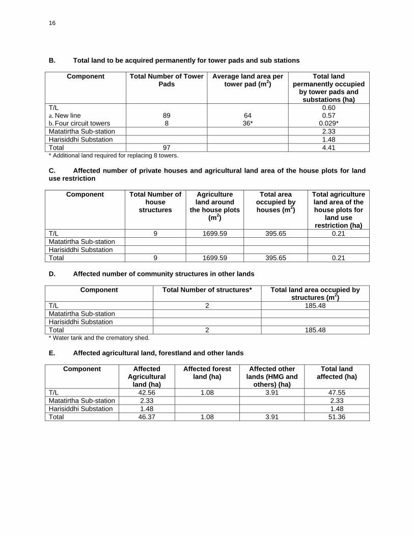
B. Total land to be acquired permanently for tower pads and sub stations
Component Total Number of Tower Pads
Average land area per tower pad (m2)
Total land permanently occupied
by tower pads and substations (ha)
T/L a. New line b. Four circuit towers
89 8
64 36*
0.60 0.57
0.029* Matatirtha Sub-station 2.33 Harisiddhi Substation 1.48 Total 97 4.41 * Additional land required for replacing 8 towers. C. Affected number of private houses and agricultural land area of the house plots for land use restriction
Component Total Number of house
structures
Agriculture land around
the house plots (m2)
Total area occupied by houses (m2)
Total agriculture land area of the house plots for
land use restriction (ha)
T/L 9 1699.59 395.65 0.21 Matatirtha Sub-station Harisiddhi Substation Total 9 1699.59 395.65 0.21 D. Affected number of community structures in other lands
Component Total Number of structures* Total land area occupied by structures (m2)
T/L 2 185.48 Matatirtha Sub-station Harisiddhi Substation Total 2 185.48 * Water tank and the crematory shed. E. Affected agricultural land, forestland and other lands
Component Affected Agricultural
land (ha)
Affected forest land (ha)
Affected other lands (HMG and
others) (ha)
Total land affected (ha)
T/L 42.56 1.08 3.91 47.55 Matatirtha Sub-station 2.33 2.33 Harisiddhi Substation 1.48 1.48 Total 46.37 1.08 3.91 51.36

17
F. Total land types affected due to restricted land use Component Restricted
Agricultural land (ha)
Restricted forest land (ha)
Restricted other lands (ha)
Total land restricted (ha)
T/L 41.96 1.08 3.91 46.95 Matatirtha Sub-station Harisiddhi Substation Total 41.96 1.08 3.91 46.95 G. Total plants and trees affected by T/L component A total of sixteen plant species are affected by the T/L component that requires felling. Of the affected plant species none are in the protection category. The details of the plants affected by T/L component are presented in Annex IV – 1. Highlights of the affected plant numbers according to size and volume are presented below.
Agricultural land Forest and other land Plant size No Wood
volume (m3) Biomass
(kg) No Wood
volume (m3) Biomass
(kg) Polo size 57 88 Tree 420 127.1 4 19.927 Sapling 61 7 Bamboo 51
65,511
13,106
Total 589 127.1 65,511 99 19.921 13,106 Note: Substation land are devoid of any trees H. Total crop affected The restricted agricultural land crops under T/L ROW may be affected during stringing of the conductors. Normal construction period will be dry season (November to Mid June). Considering the construction season, only planted wheat and maize crop may be affected. The land under permanent acquisition category (substations, tower pads and houses under ROW) will be acquired after harvesting of the crop. Under the above scenario, the effect on the crops under the T/L ROW restricted land is presented as below.
Wheat (MT) Maize (MT) Mustard (MT) Potato (MT) 81 52 2 79
Note: Crop and production are based on district averages.

18
Chapter V AFFECTED FAMILIES/PERSONS (AFs/APs)
The project-affected households/persons are those residing within the T/L right-of-way and land area of the sub-stations, who will be displaced by the dismantling and construction of transmission towers and sub-stations including those who own properties and/or conduct their economic activities within the project-affected areas. The total estimated number of affected Families (AFs) (i.e. landowners, tenants, structure owners, and business owners) for the T/L component is 2377 excluding land owned by Guthi (a community trust) and government (refer Annex V - 1). The above figures are based on the verification of survey conducted by the NEA. With an average household size of 6.5, the estimated population of APs is 15451. Out of the AFs, 1610 are landowners, 764 are tenants, and 9 are structure owners. Of the structure owners, 6 are landowners with structure and three are tenants with structures. The number of landowner and tenants, however, will be further validated during final check survey to be conducted by the contractors. From the 9 structure owners, only 8 are using their structures for residential purposes. None of the structure owners are using the structures for business purpose. Besides, there are two structures built on the government land. One structure is a water tank for community water supply and other is a shed by the side of the river for cremation purpose. These are community structures. Annex V - 2 presents the photographs of private and community structures. Matatirtha switching station component affects 27 families (i.e. landowners, and tenants). With an average household size of 6.5, the estimated population of APs is 176. Of the total AFs, 24 are landowners and 3 are tenants. The land for the planned sub-station site does not involve any structures and is exclusively used for agriculture purpose. In the planned Harisiddhi sub-station site, a total of 20 families (i.e. landowners, and tenants) are affected. With an average household size of 6.5, the estimated population of APs is 130. Of the total AFs, 17 are landowners and 3 are tenants. The site does not involve any structures and is exclusively used for agriculture purpose. In total, the project affects 2424 AFs with an estimated population of 15,756 APs. Below are the basic impact figures on lands, houses and structures etc. A. Land parcels affected
Components Total land parcels
Government owned parcels
Guthi owned parcels
Privately owned parcels
Privately owned parcels
with tenants
Guthi owned parcels
with tenants
T/L components 2,080 58 4 1,135 715 168 Matatirtha switching station
23 20 3
Harisiddhi substation
17 14 3
Total land parcels affected
2,120 58 4 1,169 721 168

19
B. Residential Structures affected
Components Pakki* one story private residential structure
Pakki two story private residential structure
Kacchi** one story private residential structure
Kacchi two story private residential structure
Total residential structure affected
T/L components
2 3 3 1 9
Matatirtha switching station
Harisiddhi substation
Total 2 3 3 1 9 * made with brick and cement; ** made with raw brick and mud. Note: Residential structures are built in land owned by APs only. Guthi (public trust) land and government owned land has no residential structures of landowners or tenants. C. Community structure affected Components Pakki underground
water tank Pakki one story
crematorium shed Total community structure affected
T/L components 1 1 2 Matatirtha switching station
Harisiddhi substation Total 1 1 2 Note: The structures are built in government land. D. Affected Families (AFs) 1. Land and residential structure affected Families Components AFs Land
owner AFs land
owner with structure
AFs tenant AFs with structture
AFs Tenant in Guthi
land
Total AFs
T/L components
1,610 6 602 3 156 2,377
Matatirtha switching station
24 3 27
Harisiddhi substation
17 3 20
Total 1,651 6 608 3 156 2,424 At places, a parcel of land is owned by more than one private landowner and at other places one land owner owns more than one land parcels. Similarly, one land parcel has more than one tenant. Hence number of parcels does not directly tally with the number of owners. Guthi land is land owned by public trust. Mostly tenants till such lands. For details of land ownership and parcels refer Annex V-1.

20
Chapter VI SOCIOECONOMIC STUDY
6.1 Methodology The team of sociologist and engineers covered the T/L stretch on foot to observe and investigate the actual site condition. A carefully designed questionnaire was used to conduct household survey of the statistically designed sampled households. The sample households were selected using a stratified random sampling method. Stratification targeted to include tower pad, right of way and affected houses. A checklist for key informant interview was used to collect other necessary primary data and to triangulate the information collected through household survey. The local people were extensively consulted during the fieldwork. This information was supplemented with other published materials and reports. Besides, a separate socio-economic study of the project relocatees (AFs who are to be displaced) was carried out. A detailed household survey on relocatees was carried out using structured questionnaires. Besides, using a separate checklist, some key informants were interviewed to triangulate the data collected through household survey. The survey team also collect impressions and other primary information by actual observation of the situation. 6.2 Results of Socio-economic Survey 6.2.1. Project Affected Families Of the total 2424 affected families a detailed survey of 200 sampled households was conducted in May 2000 by NEA consultants with the assistance of locally hired enumerators and project personnel. The data presented below are the results of the analysis of socioeconomic data obtained from the sampled households. The socioeconomic data tables are provided in Annex VI - 2. Population by Age and Sex As shown in Annex VI - 2, Table 1 the total population of the sampled household is 1263 which constitutes 663 & 600 male and female population respectively. The male/female ratio in the composition of family members in the surveyed households, males slightly outnumber females with the percentage of the family member estimated as 52.5% for male and 47.5% for female. Likewise the table also shows the sex distribution within the 15 years age difference. This shows that about 33% of the household members fall under the 0-15 years age group and about 13% are over the age of 60 years and above. This implies that, the economically active population in the project impact area accounts for more than 54% (see Annex VI- 1, Table 1). 6.2.1.2 Household Size, Type and Gender of Head The overall family size of the surveyed households in the project area has been estimated as 6.5. About 34% of all sampled houses have 2-5 family members. Similarly, another 30% and 24 % households are with 6-7 and 8-9 members respectively while the remaining 10 % have 10 and above family members. In 4 affected houses, only one person represents the family. (see Annex VI- 1, Table 2). Regarding the family type, Annex VI - 1 Table 3 shows that the single type of family is prevailing than other one, showing that the difficulties and constraints in the family's income and expenditure are slowly forcing Nepalese society to prefer "nuclear" families. The survey indicates that female population is less than the male population. Among 151 surveyed households only 14 households were found female headed, that accounts to 9.3% (see Annex VI-1, Table 4).

21
6.2.1.3 Caste and Ethnic Composition As far as the caste and ethnic composition of the sampled households is concerned, it clearly indicates a heterogeneous character. As the Annex VI. 1 Table 5 shows, Newar are the numerically dominant caste group comprising 46% of the total surveyed households, followed by the Chhetries with 32% and Brahmin 18%. Other groups are represented by the small figure below 2% only. The caste/ethnicity distribution is not uniform throughout the transmission line corridor. For example, Lalitpur district has the dominant inhabitation of Newari people comprising 56. % of the surveyed households of that district and with only 29.7% of the people from Chhetri community. Whereas, the biggest ethnic group of the Bhaktapur district is represented by the Chhetries with 40.4% and it is followed by the Newars with 31% (see Annex VI- 1, Table 5). 6.2.1.4 Educational Attainment The project area is comparatively advanced in terms of literacy. The overall literacy rate is estimated 73 % which is higher when compared to the national average of 53.74% in 2001. However, this figure is lower than the district averages of 77%, 77.7% and 70.3% for Kathmandu, Lalitpur and Bhaktapur respectively. On the other hands, females are less literate (63%) than males (81.4%). Majority (44%) of those who reported as literate acquired elementary and high school education only. The remaining 29 % have acquired education of SLC and above (see Annex VI- 1, Table 6). 6.2.1.5 Major Occupation Subsistence farming is the main occupation of the large majority of the population (45.1%) in the project area. The second largest group according to the occupation is found to be student with 28.4%. The interesting fact is that although the project impact area lies in the vicinity of the busiest trade center, the occupation by service and business of the affected person constitutes only about 9% and 3% respectively. Similarly, incapable and 'other' constitute 7% and 6% of the total sample population respectively (see Annex VI- 1, Table 7). 6.2.1.6 Gross Annual Household Income Although the income figures are not the exact representation of the situation, due to the non- availability of proper/confirming data, nevertheless, they are expected to be important as they not only show the economic condition of the sampled households but also reflect the general economic situation of all households in the impact area. The income of the households constitutes mainly two sources: income from agriculture and off- farm income from sources like service, wage labor, pension and business. The data on total income from various sources shows that although agriculture is the main occupation of the population, in total the income coming from other sources (83.3% of total) exceeds than from agriculture (16.70%). This can be contributed to the fact that the income from the agriculture is usually utilized inside the household, without any possibility to come out to the market (see Annex VI- 1, Table 8). 6.2.1.7 Settlement Patterns The availability of public facilities such as road and health facilities and productive and cultivated land in the project impact area have greatly attributed to the location of the resettlement areas. However, some major settlements are located in the places of historically famous religious sites. These settlements are usually dense and have appropriate market areas. Settlement elevations vary from 1300 m to 1450 m. Some major settlements along the transmission line alignment are Bosigaun, Taukhel, Gamcha, khadkagaun, Chasikot, wakhat, Dhapakhel, Thulagar, Sahambu, Shikartar, Makantol and Bungal. All settlements, irrespective of

22
caste/ethnicity and economic status appear similar in terms of housing arrangements and other features. In main villages, dominated by the Newar Architecture, the houses are built closely together and line the cobbled streets and alleys. The standard house has several storeys, framed doors and windows, and often a verandah overlooking the street below. Roofs are almost always of tile, slate or aluminum sheet. Usually, elaborately carved wooden doors and windows are the mark of Newar aristocracy. Most of the villages in the impact area are composed of one ethnic group, living in separate clusters based on their caste/ethnic status. There were no monuments, structures or archeological sites of major significance in the affected area. 6.2.1.8 Land Holding and Size of Affected Portion Majority of households own between 0.32 and 0.38 ha of agricultural land, among it the average of the affected land for one household is estimated to be about 0.002 ha or 0.5 % of the average land holding size (see Annex VI- 1, Table 9). Likewise, of the total 200 sample households 38, 19 and 38 households will lose more than 75%. 50 % & 25% of their land respectively due to the project activities. However, the majority (52%) will loose less than 25% of their total lands (see Annex VI- 1, Table 10). 6.2.1.9 Land Ownership In average 91 % of the affected land is the own property of the affected households, about 5% has been occupied or given to the tenant, 3 % is shared equally by owner and tenant, and no land has been rented out (see Annex VI- 1, Table 11). 6.2.1.10 Land Use and Type Agriculture is the predominant form of land use in the impact area. Other includes grazing, residential/village and public lands. The land use along the T/L route is dominantly agricultural land. The forestland in the impact area is limited and primarily located on the sides of small rivers. There are two types of agricultural lands in the project area: Khet and Pakho Bari. Khet refers to fields that have been terraced, leveled and bound for the cultivation of mainly rice. Khet is highly preferred by the local people because it usually yields three crops per annum. Pakho Bari (un- irrigated land) is rain-fed and usually terraced land. Bari is often situated above Khet and used as residential site. 6.2.1.11 Food Sufficiency The status of food sufficiency shows that 94 out of 200 households have a food deficit. The remaining households have food surplus. Among the deficit households a large majority (56%) were reported to be in the deficit for 4 to 6 months period. However about 10% of the sampled households were reported to be food deficit throughout whole year. To the questions of the source of income during the food deficit period, almost half of the sampled households replied that the only way of defeating food deficit is through daily wage labour. (see Annex VI- 1, Table 12). 6.2.1.12 Awareness and Perception of Project Nearly 80(%) of the interviewed households are aware of the plan to construct the transmission line. About 20% said that they are not aware of it. Around 75% of the households said that they are in favor of the project while about 10% mentioned that they are not in favc;>r. The rest were either undecided (10%) or simply did not indicate their position (5%). Almost all (96%) of the households are willing to be compensated for their affected properties. Very few (1 %) are willing to contribute their properties for the project, whereas the remaining 3% are undecided.
23
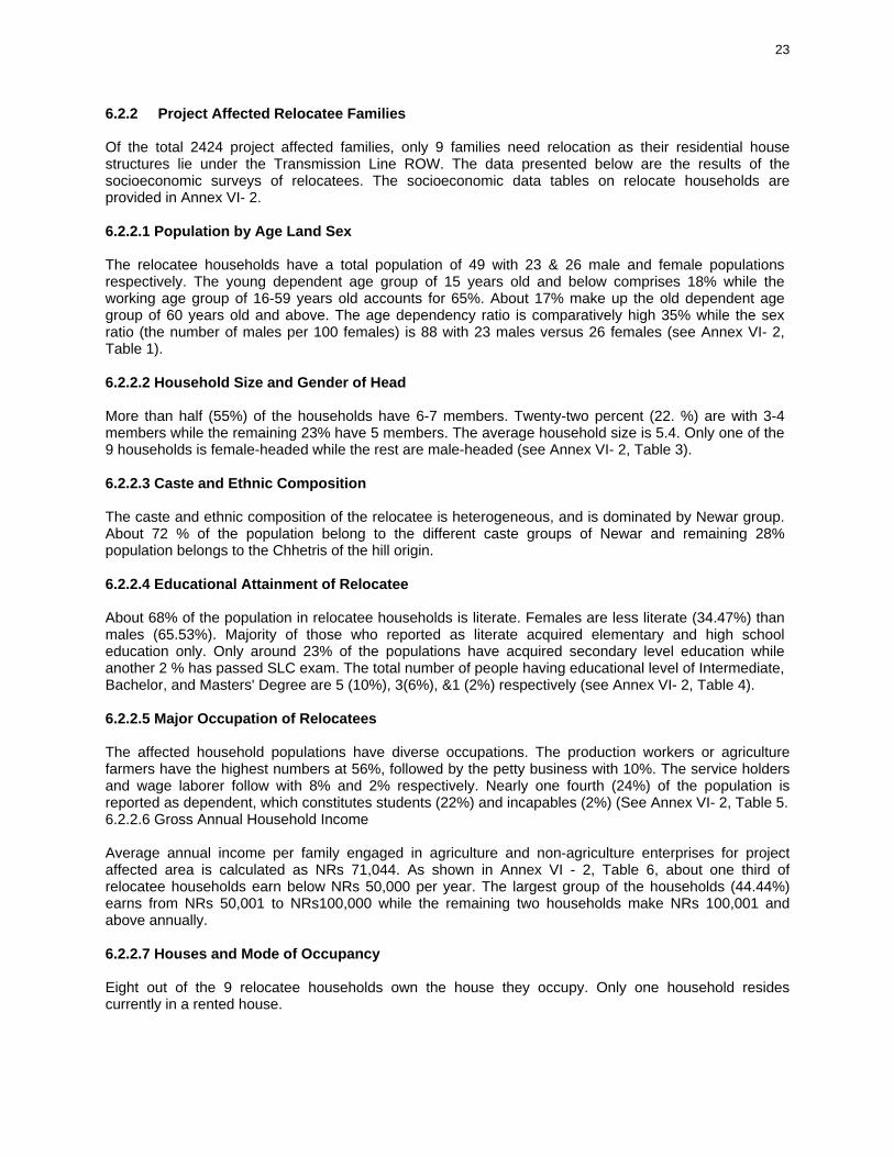
6.2.2 Project Affected Relocatee Families Of the total 2424 project affected families, only 9 families need relocation as their residential house structures lie under the Transmission Line ROW. The data presented below are the results of the socioeconomic surveys of relocatees. The socioeconomic data tables on relocate households are provided in Annex VI- 2. 6.2.2.1 Population by Age Land Sex The relocatee households have a total population of 49 with 23 & 26 male and female populations respectively. The young dependent age group of 15 years old and below comprises 18% while the working age group of 16-59 years old accounts for 65%. About 17% make up the old dependent age group of 60 years old and above. The age dependency ratio is comparatively high 35% while the sex ratio (the number of males per 100 females) is 88 with 23 males versus 26 females (see Annex VI- 2, Table 1). 6.2.2.2 Household Size and Gender of Head More than half (55%) of the households have 6-7 members. Twenty-two percent (22. %) are with 3-4 members while the remaining 23% have 5 members. The average household size is 5.4. Only one of the 9 households is female-headed while the rest are male-headed (see Annex VI- 2, Table 3). 6.2.2.3 Caste and Ethnic Composition The caste and ethnic composition of the relocatee is heterogeneous, and is dominated by Newar group. About 72 % of the population belong to the different caste groups of Newar and remaining 28% population belongs to the Chhetris of the hill origin. 6.2.2.4 Educational Attainment of Relocatee About 68% of the population in relocatee households is literate. Females are less literate (34.47%) than males (65.53%). Majority of those who reported as literate acquired elementary and high school education only. Only around 23% of the populations have acquired secondary level education while another 2 % has passed SLC exam. The total number of people having educational level of Intermediate, Bachelor, and Masters' Degree are 5 (10%), 3(6%), &1 (2%) respectively (see Annex VI- 2, Table 4). 6.2.2.5 Major Occupation of Relocatees The affected household populations have diverse occupations. The production workers or agriculture farmers have the highest numbers at 56%, followed by the petty business with 10%. The service holders and wage laborer follow with 8% and 2% respectively. Nearly one fourth (24%) of the population is reported as dependent, which constitutes students (22%) and incapables (2%) (See Annex VI- 2, Table 5. 6.2.2.6 Gross Annual Household Income Average annual income per family engaged in agriculture and non-agriculture enterprises for project affected area is calculated as NRs 71,044. As shown in Annex VI - 2, Table 6, about one third of relocatee households earn below NRs 50,000 per year. The largest group of the households (44.44%) earns from NRs 50,001 to NRs100,000 while the remaining two households make NRs 100,001 and above annually. 6.2.2.7 Houses and Mode of Occupancy Eight out of the 9 relocatee households own the house they occupy. Only one household resides currently in a rented house.

24
6.2.2.8 Type of Housing Units Majorities (55%) of the houses of the relocatee families are pakki (made with brick/stone and cement with RCC roofing) and the remaining 45% houses are kachhi (made with raw brick and mud with thatch roof/CGI roofing). Similarly, of the total 5 pakki houses, there are 3 two-storied building whereas there is only one house of kachhi category with two-storied building and the remaining houses are of one story (see Annex VI- 2, Table 7). 6.2.2.9 House Floor Area The affected houses having large-sized floor areas of 801sq.ft and over, medium-sized floor areas of 300-800 sq. ft. and those with smaller floor areas of 299 sq. ft. and below make up 33.33% each. 6.2.2.10 Housing Materials Two-thirds (66.66%) of the houses have strong roofing materials made of RCC slab and galvanized iron (G.I.) sheets while the remaining one third have thatch/tile roof made of indigenous and makeshift/salvage materials. For walling, majorities (55%) of the houses have strong materials such as concrete and wood and the remaining houses have light indigenous materials (see Annex VI- 2, Table 7). 6.2.2.11 Land Ownership All the total 9 relocatee families own more or less some areas of land they occupy/cultivate. Besides, 5 households have rented-in and 1 household has rented-out land as well. Majority (55%) of households own 5 ana to 1 ropani of land whereas the remaining households (45%) own 1 to 2 ropani of land. It is found that the affected land mostly belongs to the affected population. The Annex VI- 2, Table 3 & 8 also show that in average 57 % of the affected land is the own property of the affected households, 31 % has been taken for leased by the affected households and very small amount (3 ana) land has been rented out. 6.2.2.12 Proof of Land Ownership Almost all the relocatee households have documents to prove ownership of their affected land. Most of them have jaga dhanipurja (Land Registration Certificate). However, some merely have mal pot tireko rasit (Tax Payment Receipt) as proof of their land ownership. 6.2.2.13 Type of Land There are two types of agricultural lands in the project area: Khet and Pakho Bari. Khet refers to fields that have been terraced, leveled and bound for the cultivation of mainly rice. Khet is highly preferred by the local people because it usually yields three crops per annum. Pakho Bari (un- irrigated land) is rain-fed and usually terraced land. Bari is often situated above Khet and used for residence purpose. Majority of the affected lands falls under the agricultural land comprising of both Khet and Pakho Bari. Residential lands, commercial land, public land and those classified as mixed agricultural and industrial land comprise a small portion of the total affected lands. 6.2.2.14 Total Area of Affected Lands and Size of Affected Portion Total area of affected land of relocate families is about 4 ropani, 4 ana, 3 paisa and 2 dam (0.21 halo Around 55% of the affected lands have area less than 5 ana each. Another 33 % of the affected lands have areas in between 10 ana to 1 ropani each and the remaining 12% affected lands have area more than 1 ropani each.

25
6.2.2.15 Awareness and Perception of Project All the interviewed households are aware of the plan to construct the transmission line and they also said that they are in favor of the project. However, they strongly demanded that the project authority should compensate their affected properties. 6.2.2.16 Affected Structure and Public Places Some 11 structures will be affected by the project. Out of this figures, nine (9) are residential houses while the remaining two structures comprise of ghat (crematory) and public water tank/reservoir (see Annex VI. 2, Table 7).

26
Chapter VII SOCIOECONOMIC IMPACTS AND MITIGATING MEASURES
The project’s main adverse impact is the displacement of some families residing within the T/L ROW and in the substation areas. Except for the substation areas, minimal impact is foreseen for owners of agricultural lands on ROW that will be affected by the project since they could still continue cultivating their lands after project construction. A summary of socioeconomic impacts on APs and mitigating measures is shown in the table below:
Impact Mitigation Measures Loss of land due to permanent acquisition
• Landowners and tenants of the permanently acquired lands of ROW and substation will be compensated in cash at the replacement cost. The Compensation Fixation Committee in consultation with local government and APs shall decide the replacement costs of the land.
Land use restriction • Landowners and tenants whose land will be restricted for the construction of structures and trees shall be compensated in cash at 10% of the replacement costs of the land. The Compensation Fixation Committee in consultation with local government and APs shall decide the replacement costs of the land.
• The landowners and tenants of the restricted land use will be allowed to crop the land and the land ownership will remain with the respective landowners/tenants.
Damage to crops/plants/trees during construction
Any loss of crops/plants/trees shall be paid to landowners and tenants of the permanently acquired area based on the evaluation norms of District Forest Office and District Agricultural Office. Any loss of crops/plants/trees shall be paid to landowners and tenants of the land use restricted areas and any other areas during construction of T/L based on the evaluation norms of District Forest Office and District Agricultural Office.
Dismantling of the House and other structures and Utilities
House and other structures and utilities shall be compensated at replacement costs based on the evaluation norms of the District Development Committee. Depreciation shall not be accounted.
Transportation Allowance All the APs whose house structure is occupied permanently will be given a transportation allowance of NRs, 15,000 to transport the salvaged materials to the new place.
Disturbance to APs who are relocated
Grant of disturbance compensation to APs to tide them over while reconstruction their houses and /or adjusting to their new environment up to NRs. 21,000. The amount shall be not more than 150 days multiplied by the daily minimum wage in the project-affected area.
Disruption of Business Grants for the loss of business in amount up to NRs 30,000 will be paid or based on daily income whichever is lower as reflected on income tax return (ITR) multiplied by the number of days of business stoppage due to the project, but in no case shall it be more than 90 days.
27
Chapter VIII COMMUNITY CONSULTATION AND DIALOGUES
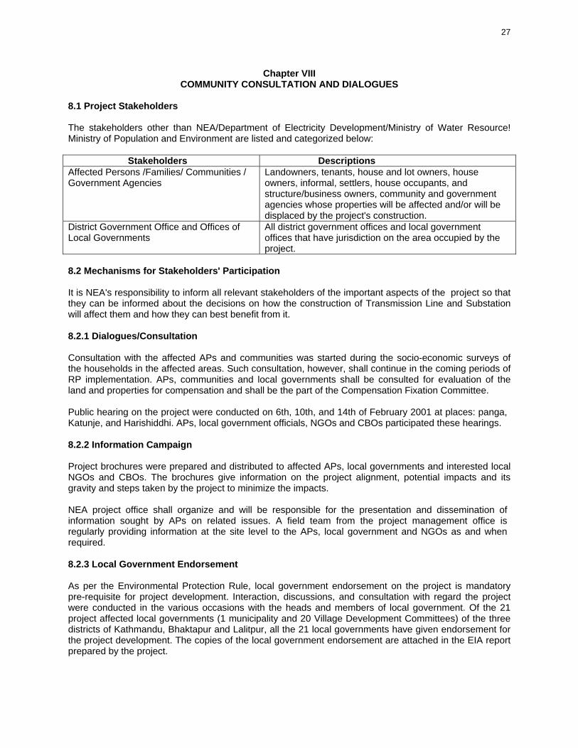
8.1 Project Stakeholders The stakeholders other than NEA/Department of Electricity Development/Ministry of Water Resource! Ministry of Population and Environment are listed and categorized below: Stakeholders Descriptions Affected Persons /Families/ Communities / Government Agencies
Landowners, tenants, house and lot owners, house owners, informal, settlers, house occupants, and structure/business owners, community and government agencies whose properties will be affected and/or will be displaced by the project's construction.
District Government Office and Offices of Local Governments
All district government offices and local government offices that have jurisdiction on the area occupied by the project.
8.2 Mechanisms for Stakeholders' Participation It is NEA's responsibility to inform all relevant stakeholders of the important aspects of the project so that they can be informed about the decisions on how the construction of Transmission Line and Substation will affect them and how they can best benefit from it. 8.2.1 Dialogues/Consultation Consultation with the affected APs and communities was started during the socio-economic surveys of the households in the affected areas. Such consultation, however, shall continue in the coming periods of RP implementation. APs, communities and local governments shall be consulted for evaluation of the land and properties for compensation and shall be the part of the Compensation Fixation Committee. Public hearing on the project were conducted on 6th, 10th, and 14th of February 2001 at places: panga, Katunje, and Harishiddhi. APs, local government officials, NGOs and CBOs participated these hearings. 8.2.2 Information Campaign Project brochures were prepared and distributed to affected APs, local governments and interested local NGOs and CBOs. The brochures give information on the project alignment, potential impacts and its gravity and steps taken by the project to minimize the impacts. NEA project office shall organize and will be responsible for the presentation and dissemination of information sought by APs on related issues. A field team from the project management office is regularly providing information at the site level to the APs, local government and NGOs as and when required. 8.2.3 Local Government Endorsement As per the Environmental Protection Rule, local government endorsement on the project is mandatory pre-requisite for project development. Interaction, discussions, and consultation with regard the project were conducted in the various occasions with the heads and members of local government. Of the 21 project affected local governments (1 municipality and 20 Village Development Committees) of the three districts of Kathmandu, Bhaktapur and Lalitpur, all the 21 local governments have given endorsement for the project development. The copies of the local government endorsement are attached in the EIA report prepared by the project.

28
8.3 Role of NGOs and CBOs As in any national development project, APs seek the assistance of non-government and/or community-based organizations (NGOs/CBOs) for a nonpartisan or impartial assessment of the project. These groups are encouraged to participate in public hearings and community dialogues and voice out their concerns about the project.

29
Chapter IX RESOLUTION OF CONFLICTS, APPEALS AND GRIEVANCE PROCEDURES
Issues, which may arise concerning the land rights and dissatisfactions on the land and property acquisition, value fixation etc. shall be addressed by the Chief District Officer and Ministry of Home as per the legal provisions of the Land Acquisition Act 1977 (section 7 and 11). Issues, which may arise concerning payment of lands, crops and improvements and relocation, will be settled by the Project Management Office (PMO). They will be assisted by NEA's legal wing to handle all the legal matters/concerns. Issues related to the insufficiency of the compensation costs shall be refereed to Compensation Fixation Committee as a last resort to settle the issue. 9.1 Setting Up a Complaint Desk The Project Management Office (PMO) shall set up a Complaint Desk at its office to be manned by administrative officer assisted by a field supervisor. All complaints/concerns shall be received at this desk and resolved immediately if minor ones and involves procedural/policies and guidelines only. Likewise, the Project Management Office (PMO) shall refer to the concerned office/group all other issues, which cannot be resolved. The APs shall be informed about the status of his concern as soon as possible. 9.2 Procedure The following procedure will be observed in the settlement of conflicts/concerns • PMO receives the issue/concern from APs and determines if there is a conflict. • AP/PMO representative discuss/resolve issue/concern. If this is settled, the process ends. • If not, PMO elevates the concern to the NEA's legal adviser for evaluation/review and resolution. • If the concern is resolved, the process ends. If not, the PMO through Legal Adviser forwards concern
to Compensation Fixation Committee, which evaluates and provides solution. If resolved at this stage, the process ends.
• If the concern remains unresolved, and If AP is still not satisfied, this is elevated to the Court of Appeals and finally to the Supreme Court by AP

30
Chapter X INSTITUTIONAL ORGANIZATION
The NEA is responsible for overall implementation of the RP based on the requirement of ADB and shall provide the necessary resources such as the budget and the manpower. To ensure smooth implementation of the RP, the different NEA departments as well as the relocatees are tasked with the following responsibilities. 10.1 Organizational Linkages and Responsibilities 10.1.1 Project Management Office (PMO)
• Conducts consultations/dialogues and project presentation with the APs and concerned VDCs, municipalities, DOCs and District Offices respectively.
• Secures project endorsements • Identifies affected households/persons and prepares initial valuation of houses/structures as a
start point to Compensation Fixation Committee • Surveys and valuates lands, crops/improvements and recommends payment of the same to the
NEA Board. • Prepares and secures approval of the RP. • Secure necessary budget for RP • Identifies affected landowners and tenants and negotiates for the acceptance of payment of
affected lands, crops, trees and plants as well as prepares DVs for the payment of the same. • Facilitates the resolution of right of-way and resettlement issues. • Implement RP and provide updates to NEA
10.1.2 Account Section, PMO Processes and disburses payments for relocation in consultation with PMO 10.1.3 Relocatees • Relocate/transfer their houses and structures outside the project boundaries within thirty (30) days
after receipt of payment due them. • Cooperate with the PMO/NEA offices and other government agencies in the implementation of the
RP. • Help maintain peace and order during and after relocation. • Comply with all the provisions set forth in the Waiver of RighVQuit Claim and Voluntary Undertaking
in connection with the payment of their houses/structures. PMO is currently carrying out and have accomplished a number of tasks listed above. 10.2 Institutional Capability Building and Strengthening Some of the staff currently working under PMO have been involved in the resettlement planning, parcellary investigation and socio-economic surveys of the APs in other NEA transmission line projects. They have skills in dealing and maintaining public relationship with the APs and in the conflict resolution. Some of the currently PMO staffs will be deputed for RP implementation. The new staff of PMO shall be given training through workshops and seminars from the experienced staffs of NEA involved in other T/L RP projects with an objective to strengthen institutional capacity building of the personals prior to the start of RP implementation.

31
Chapter XI IMPLEMENTATION SCHEDULE
11.1 Relocation Schedule As shown in Annex X - 1, the implementation of RP is targeted for completion at the end of 2005. Furthermore, community related works and resolution of issues shall continuously be undertaken until completion of RP implementation. Implementation of RP begins upon its approval both by the ADB and NEA Board. Major activities during RP implementation include final determination of costs by Compensation Fixation Committee for permanent land acquisition, land use restriction, house and other structures etc as per RP policy of the project; documentation, processing and payment of relocation compensation; and supervision and monitoring of RP. A third party monitoring team shall be engaged to oversee the implementation of the RP to ensure that its provisions are properly followed. 11.2 Relation of Relocation Activities to Project Schedule To ensure that the project will be completed on time, NEA Management assigned a Project Manager (PM) to oversee the project implementation. The PM is tasked to coordinate and monitor all the activities with the concerned NEA departments during the early stage of the project to ensure that decisions/approval of the related matters would be finished prior to actual project construction/implementation. Some relocation activities during the planning stage such as information campaigns with the APs and local governments and arrangements to facilitate final determination of compensation costs from Compensation Fixation Committee are necessary. Besides, co-ordination to obtain approvals and permission from other concerned HMG offices is equally important. Relocation is not necessary in case of substations. As described above, RP activities for T/L is in process. 11.3 Procedures for RP implementation
• Project has secured cadastral maps, VDC and DOC maps, etc. necessary for the first hand identification of land required for the projects & land ownership.
• Project has prepared a master list of the land plots and ownership/tenant status from the field book from the District survey office.
• The concerned District Administration office acquires necessary land and properties in line with the Land Acquisition Act and other related Acts/Rules/Regulations.
• Project notifies the people of the project area with plots and owners/tenants to be affected. • Project requests to land survey office to identify the land plots affected by the project and survey
and delineates the affected land to finalize the land parcels affected by the project. • Project gathers/consolidates/examines the needed documentary requirements such as land titles,
proofs of ownership, tax declarations, etc. to facilitate the payment of project claims. • Project requests District Forest Office, District Office of Housing and District Agriculture Offices to
evaluate the compensation amount of respective properties. • Public notification of the affected property by COO with details of land parcels, owners/tenants,
structures, and other property in the project affected areas. • Project assists CFC on investigation, negotiation with APs, and evaluation of the properties for
the determinations of the compensation as per RP policy. • Projects starts paying compensation amounts immediately after all Government decisions. • Project co-ordinates and conducts regular consultation with APs, local communities, NGOs, VDC
and DOC throughout process in matters related to information dissemination, identification and evaluation of the property, negotiations with APs to resolve any issues of RP.
• Project monitors the RP and prepare regular updates of RP implementation

32
11.4 Involvement of APs, Local Government and NGOs Active participation of APs, NGOs and local governments (VDC/DDC) will be encouraged to ensure the smooth and successful implementation of the through the following means: 11.4.1 APs
(i) Allowing entry for the preliminary survey of the affected areas by the project (ii) Collating of documents to support their relocation and right-of-way claims so that
assistance and grievances are submitted on time for processing. (iii) Participation in the count of improvements (crops/plants/trees) and cooperation in the
valuation of the same including those of their affected lands. (iv) Participation in the CFC meetings for evaluation of the compensation (v) Examination/review of the computations of relocation compensations and affixing their
signatures on the assistance and grants to facilitate payment of their claims. (vi) Allowing entry of the construction crew to the affected lands upon receipt of payment and
timely dismantling of their houses/structures. 11.4.2 NGOs Participation in the community dialogues/meetings to resolve issues that may arise during relocation implementation. 11.4.3 Local Governments Local Governments shall be involved in the RP process in two ways: firstly, as per the role/assignment stated in the prevailing Acts/Laws/ Rules & Regulations and secondly, on the request of the project. Major points are:
(i) Assistance to relocatees in looking for suitable places to transfer to facilitate their early relocation.
(ii) Participation in the CFC meetings for the evaluation of compensation (iii) Participation in the dialogues/meetings with the APs for the resolution of some conflicts
associated with the processing/payment of their claims. (iv) Assistance to project in the prevention of illegal encroachers or new settlers in the
affected areas to take advantage of relocation compensation and benefits being granted by the project.

33
Chapter XII MONITORING AND EVALUATION
Monitoring and evaluation are important activities of the RP because these will keep track of NEA's commitments to programs and projects and will ensure the attainment of the program's goals and objectives. While RP evaluation will be done internally by NEA through PMO. Monitoring of the RP implementation will be done both internally and externally. Internal monitoring will be undertaken by NEA through the PMO and the Department of Electricity Development/Ministry of Water Resources while external monitoring will be contracted out to a third party. Performance indicators that reflect the program's objectives will be the basis of monitoring and evaluation. The parameters/indicators for monitoring and evaluation will be as per the HMG approved EIA report. 12.1 Internal Monitoring Project will be monitoring its own concern particularly the status of their activities as well as expenditures. The expenses will be audited by the NEA Audit Department. The implementation schedule on relocation and rehabilitation will be used in monitoring the activities. Monthly status reports are prepared by the PMO on payment of RP compensation, assistance and grants. The conduct of continuing information campaigns/dialogues and issues and concerns of stakeholders are also included in the PMO report. The project management will ensure that the monitoring by PMO is conducted as per the requirement. It will regularly review the reports and provide comments and suggestions for improvements. The reports shall also be send for review and comments to Department of Electricity Development, Ministry of Water Resources and Ministry of Population and Environment for their review and suggestions. 12.2 External Monitoring The Project Manager will contract out external monitoring of the RP implementation to a third party. A term of reference will be prepared by the PMO and reviewed and agreed upon by the funding agency and the third party. NEA will provide cost from the project budget. 12.3 Post-relocation evaluation After completion of resettlement and development activities, a process and impact evaluation will be undertaken as per prevailing Laws. The evaluation will specially assess whether living standards of the relocatees have been restored or enhanced. It will also review the RP program's efficiency, impact and sustainability. The evaluation results shall serve as NEA's tool/reference to improve the formulation of future relocation programs.
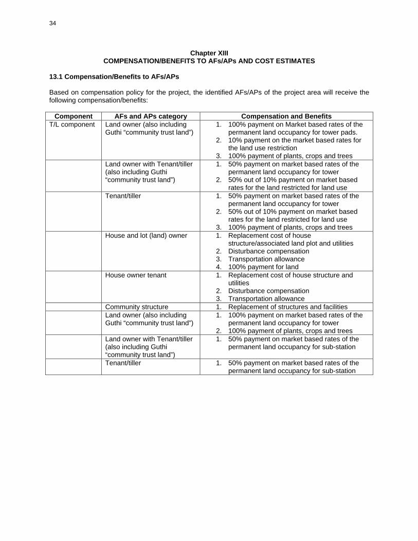
34
Chapter XIII COMPENSATION/BENEFITS TO AFs/APs AND COST ESTIMATES
13.1 Compensation/Benefits to AFs/APs Based on compensation policy for the project, the identified AFs/APs of the project area will receive the following compensation/benefits:
Component AFs and APs category Compensation and Benefits T/L component Land owner (also including
Guthi “community trust land”) 1. 100% payment on Market based rates of the
permanent land occupancy for tower pads. 2. 10% payment on the market based rates for
the land use restriction 3. 100% payment of plants, crops and trees
Land owner with Tenant/tiller (also including Guthi “community trust land”)
1. 50% payment on market based rates of the permanent land occupancy for tower
2. 50% out of 10% payment on market based rates for the land restricted for land use
Tenant/tiller 1. 50% payment on market based rates of the permanent land occupancy for tower
2. 50% out of 10% payment on market based rates for the land restricted for land use
3. 100% payment of plants, crops and trees House and lot (land) owner 1. Replacement cost of house
structure/associated land plot and utilities 2. Disturbance compensation 3. Transportation allowance 4. 100% payment for land
House owner tenant 1. Replacement cost of house structure and utilities
2. Disturbance compensation 3. Transportation allowance
Community structure 1. Replacement of structures and facilities Land owner (also including
Guthi “community trust land”) 1. 100% payment on market based rates of the
permanent land occupancy for tower 2. 100% payment of plants, crops and trees
Land owner with Tenant/tiller (also including Guthi “community trust land”)
1. 50% payment on market based rates of the permanent land occupancy for sub-station
Tenant/tiller 1. 50% payment on market based rates of the
permanent land occupancy for sub-station
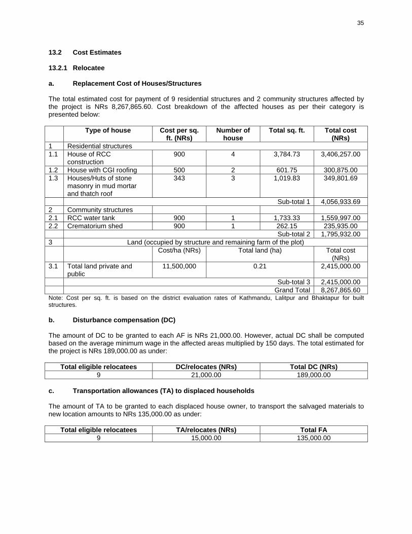
35
13.2 Cost Estimates 13.2.1 Relocatee a. Replacement Cost of Houses/Structures The total estimated cost for payment of 9 residential structures and 2 community structures affected by the project is NRs 8,267,865.60. Cost breakdown of the affected houses as per their category is presented below:
Type of house Cost per sq. ft. (NRs)
Number of house
Total sq. ft. Total cost (NRs)
1 Residential structures 1.1 House of RCC
construction 900 4 3,784.73 3,406,257.00
1.2 House with CGI roofing 500 2 601.75 300,875.00 1.3 Houses/Huts of stone
masonry in mud mortar and thatch roof
343 3 1,019.83 349,801.69
Sub-total 1 4,056,933.69 2 Community structures 2.1 RCC water tank 900 1 1,733.33 1,559,997.00 2.2 Crematorium shed 900 1 262.15 235,935.00 Sub-total 2 1,795,932.00 3 Land (occupied by structure and remaining farm of the plot) Cost/ha (NRs) Total land (ha) Total cost
(NRs) 3.1 Total land private and
public 11,500,000 0.21 2,415,000.00
Sub-total 3 2,415,000.00 Grand Total 8,267,865.60 Note: Cost per sq. ft. is based on the district evaluation rates of Kathmandu, Lalitpur and Bhaktapur for built structures. b. Disturbance compensation (DC) The amount of DC to be granted to each AF is NRs 21,000.00. However, actual DC shall be computed based on the average minimum wage in the affected areas multiplied by 150 days. The total estimated for the project is NRs 189,000.00 as under:
Total eligible relocatees DC/relocates (NRs) Total DC (NRs) 9 21,000.00 189,000.00
c. Transportation allowances (TA) to displaced households The amount of TA to be granted to each displaced house owner, to transport the salvaged materials to new location amounts to NRs 135,000.00 as under:
Total eligible relocatees TA/relocates (NRs) Total FA 9 15,000.00 135,000.00

36
13.2.2 Payments for Land Acquisition and Land Use Restriction a. Payments for permanent land acquisition T/L ROW The amount for permanent land acquisition under T/L ROW is for the tower pad occupancy area. A total of NRs 9,000,000.00 is estimated for the permanent land acquisition as under:
Number of tower
Area per Tower pad (sq. m.)
Estimated cost per sq. m. (NRs)
Total land (sq. m.)
Total cost (NRs)
97 64 1,500.00 6,000.00 9,000,000.00 Note: Land cost is based on the average district land costs. b. Payments for permanent land acquisition sub-stations The amount for permanent land acquisition for sub-station at Mataritha and Harisiddhi is NRs 54,075,781.00 as detailed below:
Name of sub-station Area occupied (ha) Rate per ha (NRs) Total Cost (NRs)
Matatirtha 2.33 14,581,880.00 33,975,781.00 Harishiddi 1.48 13,581,081.00 20,100,000.00 Total 54,075,781.00 Note: Land cost is based on the actual payments made as per the evaluation of CFC. c. Payments for land use restriction under T/L ROW The agriculture land area under T/L ROW restricted for land use is compensated at 10% of the current market value of the land prices. Price estimated for the land use restriction is NRs 48,254,000.00 as under:
Agricultural land restricted for ROW
(ha)
Average land cost per hectare (NRs)
10% of the cost per hectare ( NRs)
Total Cost (NRs)
41.96 11,500,000.00 1,150,000.00 48,254,000.00 Note: Land cost is based on the average district land costs. 13.2.3 Payments for Crops and Trees a. Payment for crops Costs for loss of crops is estimated at NRs 2.898.000.00 as under:
Crop type Estimated production (MT) Unit cost/MT (NRs) Total Cost (NRs) Wheat 81 13,000 1,053,000.00 Maize 52 14,000 728,000.00 Mustard 2 45,000 90,000.00 Potato 79 13,000 1,027,000.00 Total 2,898,000.00 Note: Unit costs are based on the averages of district market rates (Kathmandu, Lalitpur and Bhaktapur)

37
b. Payment for trees Cost for loss of trees is estimated at NRs 818,505.00 as under: Types of trees Number Unit Total Unit Cost per unit
(NRs) Total Cost
(NRs) Polo size 57 Number 57 250 14,250.00 Tree 420 m3 147.027 5,380 791,005.26 Sapling 61 Number 61 50 3,050.00 Bambpp 51 Number 51 200 10,200.00 Total 818,505.26 Note: Based on the local market rates of Kathmandu, Lalitpur and Bhaktapur districts 13.2.4 External Monitoring The amount of NRs 350,000.00 shall be provided by project to fund the external monitoring of the RP implementation. 13.2.5 Summary Particulars Cost (NRs) 1 Relocatee Rehabilitation a Replacement Cot of Houses/Structures 8,267,865.60 b Disturbance Compensation 189,000.00 c Travel Allowance for Displaced Households 135,000.00 2 Payments for land acquisition and land use restriction a Payments for permanent land acquisition T/L ROW 9,000,000.00 b Payments for permanent land acquisition sub-stations 54,075,781.00 c Payments for land use restriction under T/L ROW 48,254,000.00 3 Payments for crops and trees a Payments for crops 2,898,000.00 b Payments for trees 818,505.00 4 External Monitoring 350,000.00 Sub-Total 123,988,151.00 5 Miscellaneous 10% of Subtotal 12,398,815.16 Grand Total 136,386,966.76

38
REFERENCES [1] Handbook on Resettlement: A Guide to Good Practice, ADB, Manila, 1998. [2] Environmental Impact Assessment (EIA) (Final Report), Soil, Rock and Concrete Laboratory (SRCL),
NEA, Kathmandu, August 2002. [3] EIA of Hetauda-Bardaghat 220 kV Transmission Line Project, SRCL, NEA, Kathmandu, July 1999. [4] ACRP with Short Resettlement Planfor Thankot-Chapagaon-Bhaktapur 132 kV Tarnsmission Line
Project, SRCL, NEA, Kathmandu, May 2003. [5] EIA of Khimti-Bhaktapur-Balaju 132 kV Transmission Line Project, SRCL, NEA, Kathmandu, April
1997. [6] EIA of Jhirpu-Sunkoshi 132 kVTransmission Line Project of Bhotekoshi Hydroelectric Project, SRCL, NEA, Kathmandu, 1998. [7] Land Acquisition Act, 1977 (anlended on 1992), HMG/N. [8J Electricity Act, 1992, HMG/N. [9] Electricity Rule, 1993, HMG/N. [10] Rate Analysis of crops in Kathmandu district, 2004, District Agricultural Development Office, Kathmandu. [11] Rate Analysis of crops in Lalitpur district, 2004, District Agricultural Development Office, Lalitpur. [12] Rate Analysis of crops in Bhaktapur district, 2004~ District Agricultural Development Office,
Bhaktpaur. [13] Rate Analysis of houses in Kathmandu, Lalitpur and Bhaktapur districts, District Housing and Urban Development Offices of Kathmandu, Lalitpur and Bhaktapur districts. [14] Norms/or Forestry and Wildlife, Ministry of Forest and Soil Conservation, HMG/N, 2004.