RESERVOIR STUDY (LIMNOLOGY SECTION) · reservoir was fairly well mixed (Figure 3), Pronounced...
31
SEI R ST UDY (LIOLOGY SECTION) by R on al d E. Westley State of Washington DEPNT OF FISHERIES for FISH-PSE RESECH PR U. S. Bureau of Cer c ial Fisheries Seattle, Washington Septber 1964
Transcript of RESERVOIR STUDY (LIMNOLOGY SECTION) · reservoir was fairly well mixed (Figure 3), Pronounced...

RESERVOIR STUDY (LIMNOLOGY SECTION)
by
Ronald E. Westley
State of Washington DEPARTMENT OF FISHERIES
for
FISH-PASSAGE RESEARCH PROGRAM U. S. Bureau of Commercial Fisheries
Seattle, Washington
September 1964

TABLE OF CONTENTS
LIST OF FIGURES ••----------------------------------------------- i
LIST OF TABLES -------------------------------------------------- i
INTRODUCTION ---------------------------------------------------- 1
DESCRIPTION OF AREAS -------------------------------------------- 1
METHODS --------------------------------------------------------- 1
RESULTS --------------------------------------------------------- 2
General Limnology ----------------------------------------------- 2
Merwin Reservoir --------�---------------------------------- 2 Upper Baker Reservoir -------------------------------------- 9 Lower Baker Reservoir -------------------------------------- 9'
Difference between years ---------------------------------------- 9 ·
Merwin Reservoir ------------------------------------------- 9
Discussion •----------------------------------------------------- 22
Effects of turbine intake location temperature -------------Oxygen --------------------------------------------------��Inflow ---------------------------------------------------�Forebay area •----------------------------------------------Ef fec·t of source water (inf low) ... ---------------------------
22 22 22 22 25
S'U!1!1A.RY CID·---·CD·-------------·---.... ·------------------------------ 26
ACKNOWLEDGMENTS ------------------------------------------------- 27
REFERENCES --------------•-•·---------------------------•-------- 28
i
-
Figures
1A lB 2
3 4 5 6 7 8
9 10 11 12 13 14 15 16 17 18 19
Table
LIST OF FIGURES
Merwin Reservoir with section lines ----------------------- 3 Upper Baker and Lo:wer Baker Reservoirs with section lines - 4 Merwin Reservoir October 1963. · Trip 57A ------------------ 5 Merwin Reservoir February 1964. Trip 72b ----------------- 6 Merwin Reservoir March 1964 ------------------------------- 7 Merwin Reservoir April 1964. Trip 78a -------------------- 8 Merwin Reservoir May 1964. Trip 82e ---------------------- 10 Merwin Reservoir July 1963. Trip 44 ---------------------- 11 Upper Baker Reservoir September 1963. Trip 52a ----------- 12 Upper Baker Reservoir October 1962. Trip 9 --------------- 13 Upper Baker Reservoir December 1962. Trip 15 ------------- 14 Upper Baker Reservoir March 1963. Trip 24 ---------------- 15 Upper Baker Reservoir May 1963. Trip 36 ------------------ 16 Lower Baker Reservoir October 1963. Trip 54 -------------- 17 Lower Baker Reservoir March 1964. Trip 73 ---------------- 18 Lower Baker Reservoir May 1963. Trip 35 ------------------ 19 Merwin Reservoir January 1963. Trip 16 ------------------- 20 Merwin Reservoir January 1964. Trip 69a ------------------ 21 Merwin Reservoir March 1963. Trip 22 --------------------- 23 Merwin Reservoir March 1964. Trip 75a -------------------- 24
LIST OF TABLES
1 Limnology work completed ---------------------------------- 2
i

INTRODUCTION
This report.is presented to summarize findings and work completed to date on the federally financed program for limnological study of Merwin, Upper Baker, and Lower Baker Reservoirs. This report covers the time period from August 1962, when the field work began, to June 30, 1964. Objectives of the study were to gather information on the general hydrography and environmental conditions in respect to fish in each reservoir, to determine water flow patterns, and to gain detailed information on water conditions in the forebay areas. It was planned to study the seasonal cycle of water conditions and effect of wind, power generation,and spill on water circulation in the reservoirs. The ultimate objective is to combine these data with information on fish behavior to study the effects of the environment on the rearing and migration of juvenile salmonids. Field work has not yet been completed (scheduled for October 1, 1964) and data analysis is far from complete. The information presented is based on partial analysis of temperature data.
DESCRIPTION OF AREAS
Merwin Reservoir is located in southwest Washington on the Lewis River. The reservoir is approximately 10 miles long and 1 mile wide with a maximum depth of 200 feet and a surface area of 6,000 acres. The total water storage at full pool is 401,000 acre feet, with a normal maximum draw down of 13 feet, Turbine intakes are located at the 170 foot depth. Inflow varies seasonally from 50 cfs to 35,336 cfs while outflow varies from 636 to 35,136 cfs. Merwin Reservoir is fed from Yale Reservoir immediately upstream.
Upper Baker Reservoir is located on the Baker River in northern Washington near the Canadian border. This reservoir has a length of about 10 miles, a width of 1 mile, a maximum depth of 300 feet, and a surface area of approximately 5,000 acres. The total water storage at full pool is 285,000 acre feet with normal maximum draw down of 45 feet. Turbine intakes are located at the 100 foot depth. Inflow from the Baker River varies from 478 cfs to 17,005 cfS:Outflow varies from O cfs to 13,340 cfs. Construction of Upper Baker Dam and filling of the reservoir flooded old Baker Lake which is now present as a 180 foot deep pocket in the upper (northeastern) part of the reservoir. The surface of old Baker Lake is 70 f eet beneath the present water surface.
Lower Baker Reservoir (Lake Shannon) is located immediately below Upper Baker Reservoir on the Baker River. It is 9 miles long, 1 mile wide, and 240 feet deep. The surface area is 2,200 acres at full pool with a normal maximum draw down of 42 feet. Turbine intakes are located at the 100 foot depth. Inflow from Upper Baker varies from 715 cfs to 18,885 cfs. Outflow varies from O cfs to 16,055 cfs.
METHODS
The program was designed to determine the general physical and chemical conditions in each reservoir during the first year and during the second year to make detailed studies on daily fluctuation of water conditions, effect of
1

wind, effect of power generation, and detailed information on the water conditions in the immediate forebay areas in connection with the juvenile fish collection facilities at Merwin and Upper Baker Reservoirs.
The locations of the sampling stations in the three reservoirs are shown in Figure L Water sampling was conducted from a 17- foot outboard boat equipped with a standard hydrographic winch and a series of transducers coupled to deck meters for measuring oxygen, temperature, and conductivity.
At each station a bathythermograph cast was first made to learn the general structure of the water column. Next, detailed measurements were made with the transducers, with particular attention directed to the areas of vertical temperature change. Based on these observations, a standard water bottle cast was made, collecting samples generally from six depth intervals for oxygen content. Reversing thermometer readings at two depths provided calibration of the temperature meter at each station, and the oxygen samples provided calibration of the oxygen meter at each station. Water samples were immediately sent to the Department of Fisheries laboratory for analysis. All data, tabulation, correction, and calculations were completed as soon as possible after each trip. Analysis of the data is being accomplished by plotting vertical profiles of each variable for each trip. This analysis is based on differences occurring between trips, as well as tracing th� distribution of variables as related to the characteristics of the inflowing water.
RESULTS
Table 1 presents in tabular form the work accomplished on each of the three reservoirs through,Ju.ne 30, 1.964.
T bl 1 L' 1 k a e - ,JJI no Of!Y wor
No. of field trips
!Merwin 35
Utmer Baker 28
Lower Baker 27
General Limnology
Merwin Reservoir
1 t d comp e e . No. of individual
57
39
27
r I
No. of forebay I No. of profiles sections· studit:fs pJotted ··
I 25
I
45 I
11 15
0 16
The general seasonal cycle of water conditions in Merwin Reservoir is as follows: starting in October, the river flow was on the bottom; stratification was weak (Figure 2). In November, conditions were much the same with the river flowing along the bottom of the reservoir but cooling of the water had occurred. During December and January cooling continued and by February the reservoir was fairly well mixed (Figure 3), Pronounced seiches in the reservoir, at times, caused a build up of inflow water at the head of the reservoir. In March weak layering was evident and the river flow was detectable flowing just under the surface layer (Figure 4) while by mid-April the river flow was detected near the bottom (Figure 5) with stratification becoming stronger.
2

Jllllt
JIii!
N
r
C--
\...J'
MERWIN RESERVOIR
,1' MERWIN RESERVOIR
0 0,5 I I.& I t I l I SCAlaE-NILES
DAM
Figure lA.--Merwin Reservoir with section lines.
3

BAKER RESERVOIR
BAKER RESERVOIR
f I t ' � t SCALE - WILES
BAKER RESERVOIRS
Figure lB.--Upper Baker and Lower Baker Reservoirs with section lines.

J
V1
J ) J ] ] J J ] J ] l ] J ] J ]
:: : " .. D,.,., .t'+- �11,-L • • , • • ' • YAL& � r• A I C
J MO
·r
•1- -
-1--, ..
•
_...__
1«u....,._, �.s.,r... __ _
.,,.,�-----1 --------t
4·- ''"'3 3.""'-····--
i-- ,.... �
11,.o=,�-- IIJ)OS,ri.,.,
SCALI -=..,�NATt� -,.•;�J,�8'1 _,..,.,.. ·--
Figure 2.--Merwin Reservoir, October 1963, Trip 57a. R�=R stnS:r: .... s
Ito
__ , ... ,
•
..
j ]

J J J J J ) J J ] ] J J ) ) J I J ] ]
-i ....
•I- - ,,,,,.,, ....
0\
-1--- MO
it�3·c
.. ..
ICALIE - -=�·:t� i•·::J,_!l�E
IIEIIWIITNPTI• 12--- .. ..
Ficgure 3.--Merwin Reservoir, February 1964, Trip 72b.

J J
E :; . .. . .
•I-a-•
••!--MO
DO
-1---
J ]
'-• ,&",a·.
J ) J J
0 •
J J
•
IGALI -=-.:=t�i•';jJ._•,a -'IIIPH, ., __
J J
Figure 4. --Merwin Reservoir, March 1964, Trip 76b.
J J J J ) J )
N ..
...
NO
DO
_ ............ ,

J J
: ,,; :'I � D " 01-._
•I- -
-1---
..
-1--...
J J ] J J J J ) ] J ) J J J J
LJM· 11223qL.c J zc.::::::.:: 1xas Le 11BtScrC.re .-, 1s,09wrN, 1sr,3rM I AJID�• 1f7�S,'*f i. "JG? Sv:f.1 jle:>&&ees1i�•-
:,,c
rs_,;-..
1,cs,,
Iv,�
--.__ir.., "'""'-----.lrSD--- I -
IOALI ·=1,«::rt�...;
l•�:iJ•_!I�. --1111P?8• -.,,_
Figure s.--Merwin Reservoir, April 1964, Trip 78a.
---· .. -
,oo
na:g 111: rftllr'•
..m:=R _.._ :;i
...
NO
..
..
] ]

In May the river flow continued at intermediate depth (Figure 6). During the summer months stratification became more pronounced with the development of a well mixed epilimnion. As the epilimnion increased in temperature and depth, the river flow was forced gradually deepe-r. Also the residual bottom water was drawn off by activities of the dam (Figure 7).
Upper Baker Reservoir The general seasonal c�cle of water conditions in Baker Reservoir was
as follows: starting in September there was thermal stratification in the upper water; the river flow was at intermediate depth (bounded by the 14.o and the 15.0 C isotherms) ; the water in old Baker Lake and below the intake at the dam was isolated and identified as a mass of cold water low in oxygen content (Figure 8). In October cooling of the river water, with a resultant density increase, caused it to flow into old Baker Lake replacing the residual water which in turn flowed into and replaced the water in the pocket below the level of the i�take behind the dam (Figure 9) . During winter the reservoir was fairly well mixed in all measured properties (Figure 10) . In spring the river water was confined to the surface and separation of the hypulimnion was starting to occur (Figure 11). In May pronounced thermal stratification occurred in the upper waters with the river flow just under the zone of rapid temperature change (Figure 12) . During summer this upper layer increased in thickness but in general a well defined thermocline did not develop. Strong stratification was present below about 125 feet with cold, low oxygen water present at the deeper levels. Pronounced seiches occurred at times.
Lower Baker Reservoir Lower Baker Reservoir has not been sampled in as great detail as
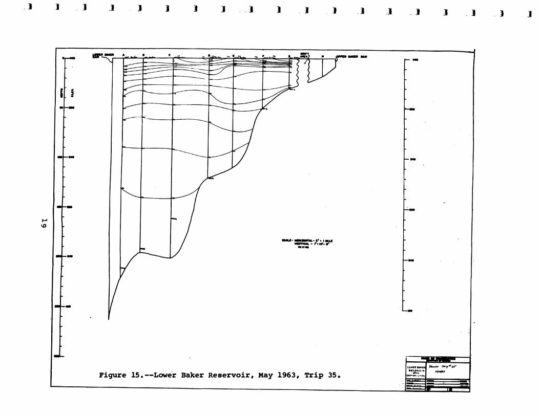
Merwin or Upper Baker Reservoirs because of the problems of massive drifts of floating debris on the surface and unlogged standing trees on the bottom. However, the data are adequate to outline the general seasonal cycle. In October stratification was weak in the upper waters but a very evident bottom layer of low oxygen and low temperature water was present below the level of the outlet, 100 feet (Figure 13). In the fall vertical mixing begins and continues until about March (Figure 14). In April and May there was indication of layering of the water but a true therm.ocline was absent (Figure 15) . As summer progressed the epilimnion developed with the river flow just under it. The water below the level of the intake during summer stratification was an isolated mass of cold water that gradually decreased in oxygen content.
Differences between years Due to the mass of data collected, we have not yet completed a compre
hensive analysis of all the differences that occurred between the 1962 - 1963 and the 1963 - 1964 years in each reservoir. The following generalization is intended primarily to point out the major differences that occurred in Merwin Reservoir only during the spring migration period of fish.
Merwin Reservoir In mid-winter (January 1963) near normal horizontal orientation of the
isotherms occurred (Figure 16), while vertical orientation of the isotherms was observed during January of 1964 (Figure 17). Vertical orientation of the isotherms is an unstable situation that is of a temporary nature, probably induced
9

_j ] - _]
·� ....
. :_ -' i...
:--I-' L I ·
I
0
-l-·-I-
C.
r L ._ ..
·� I
� �
-�M
] ] J J ]
MJh
] ] )
SCALI -e1i1:::•:t� -,.1:�J •• M�I 1111111111 TIIIP He HIIAYI-
)
/
Pigure 6.--Merwin Reservoir, M�y 1964, Trip 82e.
] ] ] ]
Ir&� 11,t:Pw,r.
Rt:�,':!O•il! H�"• D .. "IHI�
_]
,.
-
·� .. f�' ·i ...
:-:t.·
, .... ' '
..
1:
�,_____,_---=--·--
1 ]

..
l""1
• 1!1111! �
v k v .. . to ..
cw, :� I 'lo• ... rl ...
=� � I!!
-=, I: & I
� ·a ! Iii: 1!1111! .. k ...
.. ...
ii s: 0
! I I \ \
' ! \
I • .... •
...
11

ia,
...
111111
! ! I s e I
I• �I e x�
ll! ��
! "Al11 & . I ; I ' ' ·1 . · 1 NUN •• -1 •. __ ., --J----L-...L-. I .• --1__.-,J��.L�.___..__=-1 --'----'-'---�-.-. .....___l_ _ _.____.__--rl--'--.l- . ..l.- __ J..__, _ �.-L.......J I --------------,----'------'�----,-----12

! I i f 1-'-..;..i.....;.,..i........L-....i;_...1........;i._..J.._....L.-.J..-..L-.aL.........I....-J__J..- .... 1 __.__.__.__._ ...... I___.___.--L--L-....LI --l.---1..---1..---1...
i ... ,. l I ; I I I ........ ! ·--��.1 .. --1......��- ; �+I --'----l'---.L--...l-'-i----'---'-.,__...,__-:-__._--L_L.._.J....._-:!--L---1..........JL.....J... I
�, � I I I I I -.L-13

I
\ . . \ \
'·. ' . ,, '" . ·,
I
' I
I I ., I
i I
I • , ... • --L-J -r�- ...l_ I ==J•�t :::'.:::::'.='.::::::!�
=�::::::::'.:i' =:'-'�-'-�+��-'-' I I
' •. I
I
14 I J----·--..1
..

) J
� VI
I ]
•I--•·
•L. -
•I--•
-
-
-
J J I .J J ) ] J I
..
-.i-::::.·,.!,';,\.? 2'4 ....
Pigure 11.--upper Baker Reservoir� March 1963, Trip 24.
) ] J
--,,..,.,.., ·"=·· .,..... • I IIUION _.., -
] ]
--
..
-
..
,.
..

,IJl!II
,J
..
! I
0
•AW,I
••••
I
.J .
i
I 16
' �
t •l
\1< ijz!
J ic't .,. =
I I • I I I
IL · I
'

} J )
i • -
IODI--
1 ··r-
I [
-l--
-�·-
J J ] ] J J .l 1 J
k,DI�� � ·"":n i>' ':{ /{ ('/ S ,,. "" 1 JI. 1, S-,4, : ll S5 S ,We � t4U .j rb,c : V: !" :Srdarc �,: S'l <'. ARI:�{ " 1�
I
I
I
\
"--""" 1¢().
'"----J--+:
11°-t 17.o-f ,- l�I. ___ /
I �
SCALE• HORIZONTAL- s• • I MILE VERTICAL - 1•• IO'- 0� -1111'84 ·--
J
Figure 13.--Lower Baker Reservoir, October 1963, Trip 54.
J - J
-
-
l40
rHO
'-Ho
IIO
\:0•,.0f.ll'bw.,, q!'i'�"- �
!rf• c. ... , ... �,.
J J } ]

J
.... (X)
)
0
z
l :,:
t � :: .. IOl'--390
-t--
-t--
-1--
290�190
-
J
�. ---
J ] J .I J I ) J J J
11 t1 '° D E F G ,t.Rf,({ H $
PPER BU:IER DAM
I I I I I I I I s; 7 I
�2 ·c.
.,r.1sc SCALE• HORIZONTAL-:,•• I MILE
VERTICAL - ,-• 10'- o•
SHANNON TRP 73 . 2 MARCH 1914
Figure 14.--Lower Baker Reservoir, March 1964, Trip 73.
I J _J ) J _J
-·
HO
•••
...
•••
...
_)
I-' '°
J - 1
I[ i •1
-
-
-
J J J ] J J
.. -
)
� , __ ... _.._�
_J )
--·-·l"·••i.a __ ,._,.. ___ •n•
Figure 15.--Lower Baker Reservoir, May 1963, Trip 35.
] ]
--
] J
-
-
-
-
· 1 "0-• ...,.4 .._ -,..:,•.r •�!t""'"I ... � ...... ,
J -· J - J
"!!!'!!!!

! ·• I
... -�
. I I
I . I
� ,·
20

• as 0\ '°
i-ii � k E-1
� ..
191 � •• '° ;2 0\ . . 71J..c11
r-1
l�il >, 0U k !!=I " I:.�
8 ' �
� ..
k .... g k CII ID
i C .... t CII ' I •
I' ,-f
CII k � .... ..
11111
21

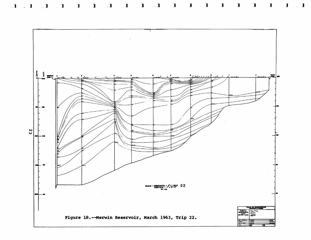
by a down reservoir wind. Stratification of the reservoir occurred during March 1963 (Figure 18). In March 1964 (Figure 19) the reservoir was uniform, and stratification did not occur until April 1964. The epilimnion was well developed during mid-May of 1963 while this did not occur until mid-June in 1964. There was not a great deal of difference between the surface water t�mperature occurring between th.e two years but stratification developed nearly one month later in 1964 than in 1963.
In both years the river:flow pattern followed the same cycle with the flow being generally along the bottom of the reservoir during the fall and winter. During early spring the river flow shifted toward the surface but in April once again shifted to the bottom. In early May it returned to the intermediate depth where it remained until fall. During summer the depth at which the river flowed in the reservoir was gradually increased due to warming and thickening of the upper layer.
DISCUSSION
During the. studies to date major differences have been observed between Merwin, Upper Baker, and Lower Baker Reservoirs and a better understanding of the reasons.for the differences has been gained. Governing factors are relative depth of the outlet, characteristics and source of the inflowing water, temperature of ,the ambient reservoir water, and wind. These are in addition. to·the obvious ones such as length, depth, width, and flow rates.
Effects of turbine intake location temperature In a reservoir such as Merwin, witq the outlet located on the bottom, it
was found that. a stronger and more pronounced thermocline, epilimnion·, and warmer .summea:-.1temperatures occurred than .at Upper Baker with a mid-depth outlet. (This is not to imply that depth of the outlet is the only reason for this difference.)
Oxygen In a reservoir with the outlet at ihe bottom it was found that lack of
oxygen does not.occur, and that oxygen levels are maintained above 8 ppm throughout the water column� In a 'reservoir.with the outlet at mid-depth isolation of the water was found below the level of the outlet for periods of up to 6 months with the oxygen levels decreasing to about 3 ppm.
Inflow .. ··-� In Merwin, with the outlet on the bottom, significant time periods were
observed when. the deep outlet and the characteristics of the inflowing water combined to produce a situation where the river :\'las flowing directly ·ctih"rough on the bottom w.ith little apparent exchange occurring between the river and the reservoir. In Upper Baker, with a mid-depth outlet, this is not as signi-ficant.
Forebay area Another result of the deep outlet is observed on the surface in the
immediate forebay area. We.have observed that in general the drawing effect from the deep outlet is not sufficient to disrupt a well developed surface layer while in the case _of the mid-depth outlet, the com�ination of greater drawing effect near the surface and the weaker stratification tend to produce disruption ·of the surface layer in the forebay. This condition appears to
2:2
] ]
l\,) w
- J
.. =: " . . .. .. • •
•1- -
-1---
] ] ) _] ) - J ] _] 1 ] - J ] '] .. )
, .. ..
IIO
f"°
N I 1-.. ./ _i..::-.. I ___..-- -1 IO
NAU -=-.:::i:r=,.•;;J,,!1� 2 2 .... -1-- ..
Figure 18.--Merwin Reservoir, March 1963, Trip 22.
nall.lll.lVIIIII' "-" 1-r..., .... R!SelNOIR 1/Wf>S. -:i:r;." #',Pl-
•
.J ]

t ! 1 I •
!""I
• ftS an ....
� '"' � � ••
:i ... ":.• � �':I '° a!dl 0\ 1s11
.... 1 .. . '5 I
� k /all : ftS
... k
I"" k
.I ....
• 0\ .... •
....
'Al,a f I I I ' I I
� NUii O I I I
24
have significance in respect to operation of the fish collection facilities in the forebays.
Effect of source water (inflow) Source and characteristics of the inflowing water appear to exert
significant influence on the structure of the water mass in each reservoir. In Merwin Reservoir rather surprising changes in depth of the river water were observed to occur. The fall and winter condition of the river flowing on the bottom of the reservoir was anticipated, as was the summer situation of the river flowing under the surface layer. However, the spring cycle of changes in depth at which the river water was found had not been anticipated. The relatively rapid change from river flow near the surface, sinking to the bottom, and shortly thereafter returning to intermediate depth is tentatively ascribed to slight changes in temperatures of the water leaving Yale Reservoir (the feed water for Merwin Reservoir), the unstable nature of the water column in Merwin during spring, and the seasonal cycle of spring warming.
In Upper Baker Reservoir some interesting changes in depth of the river flow were also observed. These changes were, however, of a different nature and with a different effect. Seasonal warming of the Baker River (the feed water for the reservoir) occurred more rapidly than the water of the reservoir and at times the river was observed flowing on the surface in the spring. One situation was noted in the spring of 1963 when a period of warm weather apparently caused rapid melting of the ice and snow which resulted in significant cooling of the river. This caused an abrupt change in the flow pattern of the river in the reservoir. The river started flowing along the bottom into old Baker Lake replacing the previously isolated water below the level of the outlet. Replacement of the deep isolated water in Baker Reservoir is usually accomplished seasonally by cooling of the Baker River during autumn, resulting in flow of the river along the bottom replacing the resident water.
The reader must bear in mind that this is a preliminary review of the data. In this report there has been no discussion of wind effects, effect of power generations, detailed studies in the forebay areas, or results of several studies conducted on Merwin Reservoir to determine daily changes in conditions. These effects are presently being analyzed. In the review of the data so far it appears as though the information gathered from this study is adequate and complete, enabling comprehensive description for each area of the parameters being investigated.
25

SUMMARY
1. A two-year limnological field study of Merwin, Baker, and Shannon Reservoirs will be completed October 1, 1964.
2. Preliminary analysis of the data has been presented in this report.
3. The seasonal cycle of some limnological conditions has been presented for Merwin, Bake� and Shannon Reservoirs.
4. A comparison of the 1962 - 1963 year with the 1963 - 1964 year in Merwin Reservoir indicates that more heating and stronger stratification occurred earlier in 1963 than 1964.
5, Oxygen levels were found to be always high in Merwin Reservoir, while the waters deeper than the outlet became oxygen deficient in Upper and Lower Baker Reservoirs.
6. The location (depth) of the outlet was found to play an important role in the structure of the water column of each reservoir. The deep outlet at Merwin tended to allow formation of the surface layer in the forebay while the mid-depth location of the outlet at Baker tended to disrupt the surface layer in the forebay.
7, Source and characteristics of the feed waters to each reservoir were found to play a major role in vertical movements of the river water in the reservoir.

ACKNOWLEDGMENTS
The writer gratefully acknowledges the help of Mr. D. T. Stuckey, leader of the field crew, who was responsible for collection of the samples and Mr. W. Hoffman, Laboratory Technician, who analyzed the samples and prepared the profiles. Dr. George Anderson helped with planning the project and analysis of the data.
27
-------- ···--�--...,....---

i-i-
REFERENCES
Anderson, E • R. and D , W , Pritchard 1951. Physical Limnology of Lake Mead, u . s . Navy Electronics Laboratory,
San Diego, California .
Eldridge , E • T • 1963. Proceedings Twelfth Pacific Northwest SYUJ.posium on Water Pollution
Research . U . s . Department of Health, Education, and Welfare, Corvallis, Oregon .
Tennessee Valley Authority and U . S. Anny Co;rps of Engineer? 1962. Internal Density Currents Created by Withdrawal from a Stratified
Reservoir : 40 p .
University of British Columbia 1958 . . The Investigation of Fish-Power Problems, H , R. MacMillan, Lectures
in Fisheries� 111 p .
28