RESEARCHARTICLE … LiveCoding,Smartphones,Kitesand LightweightDrones ... munity...
22
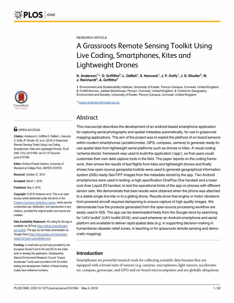
RESEARCH ARTICLE A Grassroots Remote Sensing Toolkit Using Live Coding, Smartphones, Kites and Lightweight Drones K. Anderson 1 *, D. Griffiths 2 , L. DeBell 1 , S. Hancock 1 , J. P. Duffy 1 , J. D. Shutler 3 , W. J. Reinhardt 3 , A. Griffiths 2 1 Environment and Sustainability Institute, University of Exeter, Penryn Campus, Cornwall, United Kingdom, 2 FoAM Kernow, Jubilee Warehouse, Penryn, Cornwall, United Kingdom, 3 Centre for Geography, Environment and Society, University of Exeter, Penryn Campus, Cornwall, United Kingdom * [email protected] Abstract This manuscript describes the development of an android-based smartphone application for capturing aerial photographs and spatial metadata automatically, for use in grassroots mapping applications. The aim of the project was to exploit the plethora of on-board sensors within modern smartphones (accelerometer, GPS, compass, camera) to generate ready-to- use spatial data from lightweight aerial platforms such as drones or kites. A visual coding ‘scheme blocks’ framework was used to build the application (‘app’), so that users could customise their own data capture tools in the field. The paper reports on the coding frame- work, then shows the results of test flights from kites and lightweight drones and finally shows how open-source geospatial toolkits were used to generate geographical information system (GIS)-ready GeoTIFF images from the metadata stored by the app. Two Android smartphones were used in testing–a high specification OnePlus One handset and a lower cost Acer Liquid Z3 handset, to test the operational limits of the app on phones with different sensor sets. We demonstrate that best results were obtained when the phone was attached to a stable single line kite or to a gliding drone. Results show that engine or motor vibrations from powered aircraft required dampening to ensure capture of high quality images. We demonstrate how the products generated from the open-source processing workflow are easily used in GIS. The app can be downloaded freely from the Google store by searching for ‘UAV toolkit’ (UAV toolkit 2016), and used wherever an Android smartphone and aerial platform are available to deliver rapid spatial data (e.g. in supporting decision-making in humanitarian disaster-relief zones, in teaching or for grassroots remote sensing and demo- cratic mapping). Introduction Smartphones are powerful research tools for collecting scientific data because they are equipped with a broad suite of sensors (e.g. cameras, microphones, light sensors, accelerome- ter, compass, gyroscope, and GPS) and on-board microcomputers and are globally ubiquitous. PLOS ONE | DOI:10.1371/journal.pone.0151564 May 4, 2016 1 / 22 a11111 OPEN ACCESS Citation: Anderson K, Griffiths D, DeBell L, Hancock S, Duffy JP, Shutler JD, et al. (2016) A Grassroots Remote Sensing Toolkit Using Live Coding, Smartphones, Kites and Lightweight Drones. PLoS ONE 11(5): e0151564. doi:10.1371/journal. pone.0151564 Editor: Krishna Prasad Vadrevu, University of Maryland at College Park, UNITED STATES Received: October 27, 2015 Accepted: March 1, 2016 Published: May 4, 2016 Copyright: © 2016 Anderson et al. This is an open access article distributed under the terms of the Creative Commons Attribution License, which permits unrestricted use, distribution, and reproduction in any medium, provided the original author and source are credited. Data Availability Statement: All coding for the app is available via GIThub (https://github.com/nebogeo/ uav-toolkit). The app can be freely downloaded via Google Store (https://play.google.com/store/apps/ details?id=foam.uavtoolkit&hl=en). Funding: A small start-up fund was provided by the European Social Fund to KA and DG for the initial work to develop the application. Subsequently, Natural Environment Research Council “Impact Accelerator” funds were provided to KA for further testing and development. Neither of these funding routes have reference numbers.
Transcript of RESEARCHARTICLE … LiveCoding,Smartphones,Kitesand LightweightDrones ... munity...
RESEARCH ARTICLE
A Grassroots Remote Sensing Toolkit UsingLive Coding, Smartphones, Kites andLightweight DronesK. Anderson1*, D. Griffiths2, L. DeBell1, S. Hancock1, J. P. Duffy1, J. D. Shutler3, W.J. Reinhardt3, A. Griffiths2
1 Environment and Sustainability Institute, University of Exeter, Penryn Campus, Cornwall, United Kingdom,2 FoAM Kernow, Jubilee Warehouse, Penryn, Cornwall, United Kingdom, 3 Centre for Geography,Environment and Society, University of Exeter, Penryn Campus, Cornwall, United Kingdom
AbstractThis manuscript describes the development of an android-based smartphone application
for capturing aerial photographs and spatial metadata automatically, for use in grassroots
mapping applications. The aim of the project was to exploit the plethora of on-board sensors
within modern smartphones (accelerometer, GPS, compass, camera) to generate ready-to-
use spatial data from lightweight aerial platforms such as drones or kites. A visual coding
‘scheme blocks’ framework was used to build the application (‘app’), so that users could
customise their own data capture tools in the field. The paper reports on the coding frame-
work, then shows the results of test flights from kites and lightweight drones and finally
shows how open-source geospatial toolkits were used to generate geographical information
system (GIS)-ready GeoTIFF images from the metadata stored by the app. Two Android
smartphones were used in testing–a high specification OnePlus One handset and a lower
cost Acer Liquid Z3 handset, to test the operational limits of the app on phones with different
sensor sets. We demonstrate that best results were obtained when the phone was attached
to a stable single line kite or to a gliding drone. Results show that engine or motor vibrations
from powered aircraft required dampening to ensure capture of high quality images. We
demonstrate how the products generated from the open-source processing workflow are
easily used in GIS. The app can be downloaded freely from the Google store by searching
for ‘UAV toolkit’ (UAV toolkit 2016), and used wherever an Android smartphone and aerial
platform are available to deliver rapid spatial data (e.g. in supporting decision-making in
humanitarian disaster-relief zones, in teaching or for grassroots remote sensing and demo-
cratic mapping).
IntroductionSmartphones are powerful research tools for collecting scientific data because they areequipped with a broad suite of sensors (e.g. cameras, microphones, light sensors, accelerome-ter, compass, gyroscope, and GPS) and on-board microcomputers and are globally ubiquitous.
PLOSONE | DOI:10.1371/journal.pone.0151564 May 4, 2016 1 / 22
a11111
OPEN ACCESS
Citation: Anderson K, Griffiths D, DeBell L, HancockS, Duffy JP, Shutler JD, et al. (2016) A GrassrootsRemote Sensing Toolkit Using Live Coding,Smartphones, Kites and Lightweight Drones. PLoSONE 11(5): e0151564. doi:10.1371/journal.pone.0151564
Editor: Krishna Prasad Vadrevu, University ofMaryland at College Park, UNITED STATES
Received: October 27, 2015
Accepted: March 1, 2016
Published: May 4, 2016
Copyright: © 2016 Anderson et al. This is an openaccess article distributed under the terms of theCreative Commons Attribution License, which permitsunrestricted use, distribution, and reproduction in anymedium, provided the original author and source arecredited.
Data Availability Statement: All coding for the app isavailable via GIThub (https://github.com/nebogeo/uav-toolkit). The app can be freely downloaded viaGoogle Store (https://play.google.com/store/apps/details?id=foam.uavtoolkit&hl=en).
Funding: A small start-up fund was provided by theEuropean Social Fund to KA and DG for the initialwork to develop the application. Subsequently,Natural Environment Research Council “ImpactAccelerator” funds were provided to KA for furthertesting and development. Neither of these fundingroutes have reference numbers.
‘Mobile phone sensing’ [1] is emerging as a new field of research and a growing number of sci-entists are developing ways of exploiting the technological capabilities of smartphones. Exam-ples include social science investigations [2], human population mapping for epidemiology[3,4], ecological data capture [5], atmospheric monitoring [6] and clinical studies [7,8]. Smart-phones are typically equipped with a broad suite of sensors, designed to service the informationrequirements of users and multinational developers alike–they are location-aware, and applica-tions downloaded by users can transmit information back to providers. This is a capability thatcan be exploited through the programmable nature of smartphones—sensors developed forproviding location-based services can now be hacked using readily available computingresources that offer a “low barrier of entry for third-party programmers” [1].
A somewhat untapped opportunity lies in converting the smartphone into an all-inclusiveor self-contained remote sensing device that not only captures images, but also records themetadata from various phone sensors coincidently (e.g. GPS, and sensor attitude data). Remotesensing is the science of acquiring spatial, spectral or temporal information about objects with-out making physical contact with the object. Typically remote sensing data comprise imagesacquired from sensors on platforms such as piloted aircraft or satellites but a new self-service,and to some extent, ‘grassroots’ (participatory and distributed) remote sensing revolution isunderway making use of drones and kites as platforms for proximal observations of environ-mental phenomena [9–11]. These platforms cannot carry the heavy payloads used on satellitesor aircraft, but they offer a more flexible means of timely and responsive survey, and their lowflying capability means that high spatial resolution data can be captured easily. For example inthe aftermath of a humanitarian disaster the ability to rapidly and cheaply survey damage andsearch for survivors is more readily achieved from a lightweight and portable platform like adrone or a kite [12] than from a piloted aircraft or satellite. The resolution of data from low-fly-ing platforms such as drones and kites means that the data are more useful and easily inter-preted in such settings. Additionally smartphones provide a means for participatory mapmaking in places where global datasets (e.g. Google Earth) lack spatial fidelity, and where com-munity tools (e.g. OpenStreetMap) provide platforms for sharing open source spatial informa-tion amongst individuals [13,14]. Indeed, movements such as Humanitarian Street Map(https://hotosm.org/) could benefit greatly from the low-cost digital mapping opportunityoffered a kite or lightweight drone equipped with a ready-to-use smartphone for capturingaerial data.
The status quo for drone- and kite-based aerial mapping is to use either camera systemswith wired triggers (e.g. where a camera is triggered to take a photograph by an on-board auto-pilot), cameras fitted with intervalometers, or cameras hacked to give improved autonomousfunctionality (e.g. using tools such as the Canon Hack Development Kit). A key challenge isenabling the camera to capture images without the need for human intervention once airborne.Data processing then uses complex software (e.g. ‘structure-from-motion’ software) to convertthe resulting aerial photography data into ready-to-use orthorectified maps and three-dimen-sional point clouds, where required [15–18]. Whilst these approaches generate high quality sci-entific products, for many basic mapping applications the workflow is too complex (e.g. wiringthe camera to an autopilot trigger is non-trivial, and the post-processing stage requires highperformance software and computing), and the detail in and complexity of the resulting prod-ucts exceeds what is really needed. For many applications basic aerial photography data are suf-ficient to enable identification of landscape features and to map environmental patterns [19].This paper is concerned with developing an ‘appropriate technology’ [20] toolkit for basicautonomous image capture using a mobile phone. We asked: can a basic smartphone, with itsplethora of on-board sensors (accelerometer, GPS, compass, camera) be used to generateready-to-use spatial data from lightweight aerial platforms such as drones or kites?
Remote Sensing Using Smartphones
PLOS ONE | DOI:10.1371/journal.pone.0151564 May 4, 2016 2 / 22
Competing Interests: The authors have declaredthat no competing interests exist.
Smartphones contain everything necessary to allow geo-tagged images to be delivered, beingequipped with high resolution digital cameras, on-board computer processors, GPS receivers,and typically accelerometers and a compass. There are a variety of useful opportunities in com-bining data from these various sensors and so, we sought to develop an application that con-verted a smartphone into an autonomously triggered drone- or kite-ready map-making device.
This paper describes the development, testing and evaluation of a bespoke smartphone appfor automatically collecting and generating geotagged aerial images, and suitable for deploy-ment on any lightweight drone or kite aerial photography (KAP) rig. The manuscript detailsthe technical approach, the results of field tests on kites and lightweight drones and discussesthe challenges with deployment and data processing. The code and app developed are open-source and freely available for use.
Methods and MaterialsThe app was designed to be implemented on an Android smartphone handset. Android pro-vides the most flexible platform, allowing the app to be developed as an open-source toolkit. Atthe time of development, the global distribution of Android smartphones greatly exceeded thatof other operating systems (in the first quarter of 2015 the global market share of Android wasreported to be 78% by the International Data Corporation [21]), therefore offering the mostubiquitous platform for global uptake.
A limited number of similar smartphone apps for remote sensing exist. Those that do existare primarily for citizen science applications where ground-based validation data are needed tohelp improve the quality and validity of products such as global land cover maps. Two suchapps are ‘Field Photo’ [22] and ‘GeoWiki Pictures’ [23]. Both offer a route for users to capturegeo-tagged images of landscape features, allowing the organisations who administer the appsto use these data for broader purposes. In both cases, the user is required to trigger the cameraon the handset, and the app then records various metadata describing the conditions and loca-tion of the photograph. In ‘Field Photo’ the app simply logs the GPS location whilst ‘GeoWikiPictures’ also captures metadata describing the compass angle and direction of tilt. Neither appallows the user to programme the conditions under which the camera is triggered or to allowthe device to trigger automatically. Equally, both of these apps are static, and developmentsand changes can only be implemented by the developers. It was these two functions that werecritical to our application:
1. The need for a user to press a button to trigger data capture is not feasible when the deviceis airborne, so it was essential that our app would allow the camera and sensors on thesmartphone to function autonomously after set-up
2. A ‘fixed’ app that prevents the user from making changes to the way images are capturedcan be restrictive in operational settings, so we wanted to make this flexible and program-mable by the end-user in an accessible way.
Critical design stepsIn designing the app it was first necessary to identify the critical steps to turn a standardAndroid smartphone handset into a remote sensing device. A key focus of the design was totrigger the camera to capture photographs automatically, whilst simultaneously recordingmetadata describing other conditions (position, direction, angle of acquisition, time). Severalsteps were followed in the design of the app for this purpose. The technical specification of theapp dictated that it had to be able to:
Remote Sensing Using Smartphones
PLOS ONE | DOI:10.1371/journal.pone.0151564 May 4, 2016 3 / 22
1. Identify and capture information about the full suite of sensors on the smartphone (whichvaries between handset models).
2. Capture information from the smartphone describing the camera model (field of view, pixelresolution, shutter speed).
3. Control the camera so that it could be triggered to acquire images given a set of pre-definedcapture parameters (e.g. a timed trigger or a positional trigger).
4. Simultaneously record data from the phone’s GPS to geolocate and timestamp each image,and use the accelerometer and compass to record the attitude (pitch, roll and heading) ofthe phone such as would be achieved in a typical ‘aircraft attitude’ data stream on board aremote sensing survey aircraft, or by a drone autopilot.
5. Store metadata as linked records to each individual photographic image.
A second phase of development focused on developing a user-configurable app. This wasconsidered essential because a fixed format application that could only generate time-triggeredimage capture, or GPS-triggered image capture would not necessarily suit all potential users.An intention of this project was to work more closely on a flexible app design that allowedusers to change the conditions under which the camera trigger was activated–allowing, forexample, attitude-based quality control (e.g. only capture an image if the camera is level andpointing downwards). To enable this flexible functionality, a visual coding methodology wasfollowed.
A third phase of development was to experiment with an open-source approach for post-processing the captured images into Geographical Information Systems (GIS)-ready geo-TIFFs, after the images had been downloaded from the smartphone. This approach requirednew code to convert the image jpeg into GIS-format data.
Visual coding methodologyThe conventional app design process assumes that the purpose of the system being designed isfixed, and a programmer’s job is to provide features that solve existing problems for a client. Inthe case of experimental research, and in this project, these relationships are not so clearlydefined and this led us to pursue a more flexible approach to the app design, specifically draw-ing on research in visual and live coding. Visual coding is a way of enabling simple program-ming by manipulating program elements graphically rather than by through text definition.Visual coding allows for end-user development (EUD; a more flexible approach to softwareproduction by people with expertise in other domains, and those working towards goals sup-ported by computation [24]) of apps through live coding (where coding is designed and imple-mented on the fly). Live coding is widely used within the arts, for example, in musicperformance [25,26] and is increasingly used as a tool for teaching introductory programming[27]. As a programming tool itself, live coding can result in many new, flexible approaches toprogramming. Live coding was trialled here to allow for EUD within the app. We developed anapproach that allowed users to program the app using the phone’s touch screen, using a systembased on ‘Scheme Bricks’ [28] which utilises drag and drop positioning of logical blocks to con-struct expressions which are evaluated in flight by a tinyscheme [29] interpreter. Blocks arepicked using Android's ‘long press’ function, and haptic feedback was provided by vibration toindicate successful selection.
The nature and quantity of sensors in mobile devices are changing rapidly and the suite ofsensors available varies from one handset to another. For this reason, we did not wish to stipu-late that a specific sensor set should be required to allow the app to work, but the minimum
Remote Sensing Using Smartphones
PLOS ONE | DOI:10.1371/journal.pone.0151564 May 4, 2016 4 / 22

requirement was GPS and a camera. The addition of numerous combinations of other sensorswas anticipated to enhance the remote sensing approach, so flexibility in calling on a variety ofsensors was an advantage that was only possible through use of an EUD approach. In manysurvey settings, it is also helpful to be able to change the behaviour of the software to performspecialist functions. Such flexibility in the app design is particularly important in a researchcontext where researchers might also have experience of scripting and programming and wishto make their own changes. Finally, with airborne mapping there are sometimes local condi-tions (e.g. variable wind, changing light conditions) that require different camera triggers orimaging behaviour. The ability to make adjustments to the program behaviour in the fieldwithout requiring a full development toolchain (e.g. laptops and cables) was therefore highlyattractive.
The app was designed with a completely open EUD capability whilst also offering threeexample programs for the most commonly used modes of image capture: a simple timer to trig-ger photo capture every three seconds whilst simultaneously recording sensor data describingthe orientation and GPS position of the images; and two further programs that calculated theoverlap of photos using different methods, driven by the on-board GPS to mitigate against theapp collecting too many photographs. For EUD four kinds of programming block wereavailable:
• Triggers: these are time or space based blocks that go on the top level of a program to triggersubsequent actions. They trigger based on a simple timer (when-timer), distance coveredusing GPS (when-moved-metres) or distance from all previous trigger locations (when-in-new-location).
• Actions: used to display data for debugging, for feedback–sound/vibrate, or to record data tothe database.
• Sensors: the app lists all types of sensors on-board the smartphone, as exposed by Android'sOS (for example, these may include sensors such as: accelerometer, temperature, gravity,gyroscope, light, linear acceleration, magnetic field, orientation, pressure, proximity, relativehumidity, rotation vector, significant motion, camera, and GPS coordinates).
• Mathematical expressions: are provided for calculations to be carried out in flight, for exam-ple the coverage of a photograph based on the camera angle and altitude.
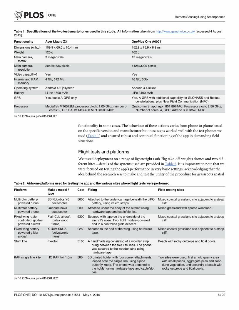
Tests on android smartphone platformsTwo smartphones were used to test the app–a low-cost Android handset (Acer Liquid Z3) anda more advanced Android handset (OnePlus One A0001). Both were chosen because theyoffered the necessary basic sensors for aerial photographic survey–a GPS and a camera. Thetwo smartphones were also chosen because they offered different capabilities in terms of otheron-board sensors, with the OnePlus One A0001 model offering a richer set of on-board sensorsfor metadata collection. Table 1 shows the basic specifications of each smartphone.
Automatic image capture is considered a privacy problem in normal smartphone use andthus is contrary to usual Android design guidelines. A camera timer mode had to be coded toover-ride this restriction. In addition we needed to take steps to prevent accidental buttonpresses or screen activity during flight or attachment to the vehicle in use. The app thereforeincluded a 'camera lock' feature that made the app full screen to prevent operating system (OS)navigation buttons being pressed whilst in use. The app could then be stopped by using a long-press on the power button to cease data capture. Both the key-guard screen and rotation layoutchanging was disabled by the app, because this was found to interfere with the camera
Remote Sensing Using Smartphones
PLOS ONE | DOI:10.1371/journal.pone.0151564 May 4, 2016 5 / 22
functionality in some cases. The behaviour of these actions varies from phone to phone basedon the specific version and manufacturer but these steps worked well with the test phones weused (Table 1) and ensured robust and continual functioning of the app in demanding fieldsituations.
Flight tests and platformsWe tested deployment on a range of lightweight (sub-7kg take-off-weight) drones and two dif-ferent kites—details of the systems used are provided in Table 2. It is important to note that wewere focused on testing the app’s performance in very basic settings, acknowledging that theidea behind the research was to make and test the utility of the procedure for grassroots spatial
Table 1. Specifications of the two test smartphones used in this study. All information taken from http://www.gsmchoice.co.uk/ [accessed 4 August2015].
Functionality Acer Liquid Z3 OnePlus One A0001
Dimensions (w,h,d) 109.9 x 60.0 x 10.4 mm 152.9 x 75.9 x 8.9 mm
Weight 120 g 162 g
Main camera,matrix
3 megapixels 13 megapixels
Main camera,resolution
2048x1536 pixels 4128x3096 pixels
Video capability? Yes Yes
Internal and RAMmemory
4 Gb; 512 Mb 16 Gb; 3Gb
Operating system Android 4.2 jellybean Android 4.4 kitkat
Battery Li-Ion 1500 mAh LiPo 3100 mAh
GPS Yes, basic A-GPS only Yes, A-GPS with additional capability for GLONASS and Beidouconstellations, plus Near Field Communication (NFC).
Processor MediaTek MT6572M, processor clock: 1.00 GHz, number ofcores: 2, GPU: ARM Mali-400 MP1 @500 MHz
Qualcomm Snapdragon 801 8974AC, Processor clock: 2.50 GHz,Number of cores: 4, GPU: Adreno 330 @578 MHz
doi:10.1371/journal.pone.0151564.t001
Table 2. Airborne platforms used for testing the app and the various sites where flight tests were performed.
Platform Make / model /type
Cost Fixing Field testing sites
Multirotor battery-powered drone
3D Robotics Y6hexacopter
£600 Attached to the under-carriage beneath the LiPObattery, using velcro straps.
Mixed coastal grassland site adjacent to a steepcliff.
Multirotor battery-powered drone
Quanum novaquadcopter
£300 Attached under the body of the aircraft usinghardware tape and cable/zip ties.
Mixed grassland with sparse woodland.
Fixed wing radiocontrolled, glo-fuelpowered aircraft
Flair Cub aircraft(balsa woodframe)
£300 Secured with tape on the underside of theaircraft’s nose. Two flight modes–poweredand in a controlled glide descent.
Mixed coastal grassland site adjacent to a steepcliff.
Fixed wing battery-powered glideraircraft
X-UAV SKUA(polystyreneframe)
£250 Secured to the end of the wing using hardwaretape.
Mixed coastal grassland site adjacent to a steepcliff.
Stunt kite Flexifoil £100 A handmade rig consisting of a wooden striphung between the two kite lines. The phonewas secured to the wooden strip usinghardware tape.
Beach with rocky outcrops and tidal pools.
KAP single line kite HQ KAP foil 1.6m £80 3D printed holder with four corner attachments,looped onto the single line using alpinebutterfly knots. The phone was attached tothe holder using hardware tape and cable/zipties.
Two sites were used, first an old quarry areawith small ponds, aggregate piles and sand-dune vegetation, and secondly a beach withrocky outcrops and tidal pools.
doi:10.1371/journal.pone.0151564.t002
Remote Sensing Using Smartphones
PLOS ONE | DOI:10.1371/journal.pone.0151564 May 4, 2016 6 / 22
mapping. For this reason, we tried to avoid using bespoke holders or specialised mounts toattach the smartphone to the airborne platform, instead focusing on using attachments or fit-tings already on the drones, or easily made for kites. This allowed us to test the performance ofthe technology in settings that were most realistic given the intended audience.
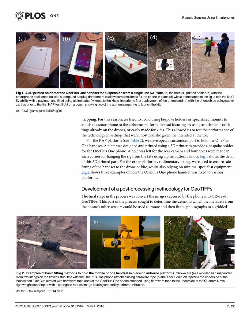
For the KAP platform (see Table 2), we developed a customised part to hold the OnePlusOne handset. A plate was designed and printed using a 3D printer to provide a bespoke holderfor the OnePlus One phone. A hole was left for the rear camera and four holes were made ineach corner for hanging the rig from the kite using alpine butterfly knots. Fig 1 shows the detailof this 3D printed part. For the other platforms, rudimentary fixings were used to ensure safefitting of the handset to the drone or kite, whilst also relying on minimal specialist equipment.Fig 2 shows three examples of how the OnePlus One phone handset was fixed to variousplatforms.
Development of a post-processing methodology for GeoTIFFsThe final stage in the process was convert the images captured by the phone into GIS-readyGeoTIFFs. This part of the process sought to determine the extent to which the metadata fromthe phone’s other sensors could be used to rotate and then fit the photographs to a gridded
Fig 1. A 3D printed holder for the OnePlus One handset for suspension from a single line KAP kite. (a) the bare 3D printed holder (b) with thesmartphone positioned (c) with superglued earplug dampeners to allow compression to fix the phone in place (d) with a stone taped to the jig to test the kite’sfly-ability with a payload, and fixed using alpine butterfly knots to the kite’s line prior to first deployment of the phone and (e) with the phone fixed using cable/zip ties prior to the first KAP test flight on a beach showing two of the authors preparing to launch the kite.
doi:10.1371/journal.pone.0151564.g001
Fig 2. Examples of basic fitting methods to hold the mobile phone handset in place on airborne platforms. Shown are (a) a wooden bar suspendedfrom two strings on the flexifoil stunt kite with the OnePlus One phone attached using hardware tape (b) the Acer Liquid Z3 taped to the underside of thebalsawood Flair Cub aircraft with hardware tape and (c) the OnePlus One phone attached using hardware tape to the underside of the QuanumNovalightweight quadcopter with a sponge to reduce image blurring caused by airframe vibration.
doi:10.1371/journal.pone.0151564.g002
Remote Sensing Using Smartphones
PLOS ONE | DOI:10.1371/journal.pone.0151564 May 4, 2016 7 / 22

map projection and is a completely novel and bespoke approach for which existing software isnot available. This process was developed and tested using a simple python script alongsidefreely available and open-source tools from the Geospatial Data Abstraction Library (GDAL[30]). Three steps were followed:
1. The sensor metadata captured simultaneously by the app and stored in the on-phone data-base were extracted and stored as a SQLite database. The database was used to match meta-data records to specific photographs.
2. The metadata in the SQLite database were then assimilated into GDAL and converted usinggdal_translate [30] to generate a set of ground control points describing the geographiclocation of each corner of each image. We experimented with various sensor combinationsto determine which produced the best results.
3. The result of 2 was then fed into the ‘gdalwarp’ utility tool [30], once to process the pixeldata and a second pass to convert the coordinates to EPSG:3857 (a geographic projectioncommonly used for web-mapping applications) so that the orientation and position of theimages could be checked against independent aerial photography datasets of the same site.
Open source reporting and development changesIn the spirit of grassroots and open-source movements, the app is free for any Android user todownload. The process of source control and a full commit log for the entire process describingthe development of the app is available and freely accessible through a Github repository and isupdated each time changes are made to the app [31].
Results
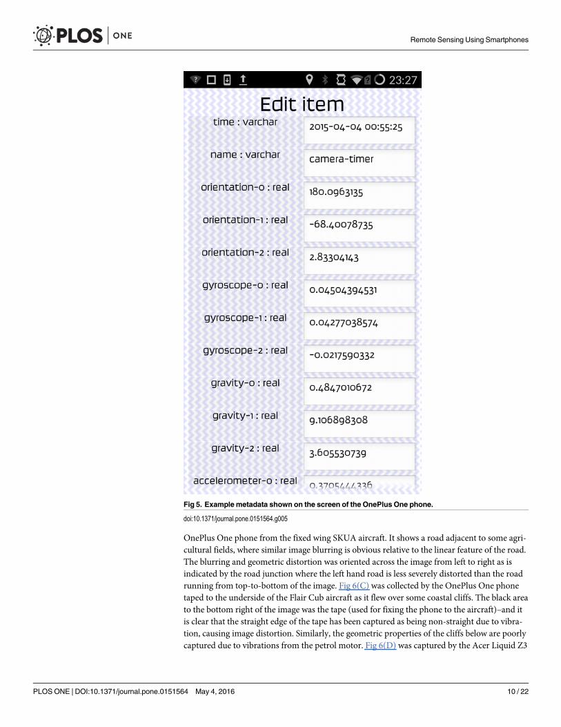
Visual coding resultsFig 3 shows screenshots from version 0.6 of the app. Fig 3(A) shows the opening screen of theapp whilst Fig 3(B) shows the coding blocks for a 3 second camera trigger where various othersensors are also triggered and a ‘ping’ noise is activated per acquisition. Fig 3(C) shows anexample of live coding where the orientation sensor has been ‘picked’ by the user to move itaround within the coding framework. The buttons shown in Fig 3(C) at the bottom of the appscreenshot show the ‘flight lock’ button which can be activated once the program is running(bottom right button)–this was designed to deactivate all other activity on the phone so thatthe app could run without being interfered by other processes. The rubbish bin icon/block atthe bottom of Fig 3(B) and 3(C) is where unwanted blocks can be placed during live coding.Fig 4 shows the different block types available for live coding the app. Fig 5 shows the metadatarecorded by the app for a single test acquisition, displayed when the ‘view data’ (See Fig 3(A))button was pressed within the app. This gives the user of the app an immediate in situ view ofthe data stream from the phone sensors.
Results from flight testsResults from powered lightweight drones. Flight tests from powered lightweight drone
platforms generated a range of results which were used to evaluate the performance of the app.The main issue with deployment on powered drones (both multi-rotor and fixed wing aircraft)was vibration in flight. Due to the fact that we used simple, non-vibration dampened fixingsfor the phones there was always some in-flight vibration which transferred to the devices. Thisgave rise to a range of image quality issues, as shown in Fig 6. In Fig 6(A) we show an annotated
Remote Sensing Using Smartphones
PLOS ONE | DOI:10.1371/journal.pone.0151564 May 4, 2016 8 / 22
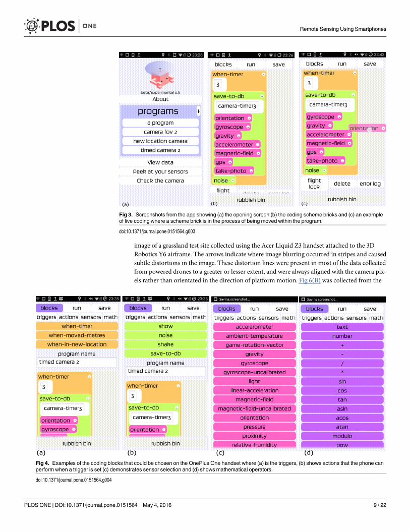
image of a grassland test site collected using the Acer Liquid Z3 handset attached to the 3DRobotics Y6 airframe. The arrows indicate where image blurring occurred in stripes and causedsubtle distortions in the image. These distortion lines were present in most of the data collectedfrom powered drones to a greater or lesser extent, and were always aligned with the camera pix-els rather than orientated in the direction of platform motion. Fig 6(B) was collected from the
Fig 3. Screenshots from the app showing (a) the opening screen (b) the coding scheme bricks and (c) an exampleof live coding where a scheme brick is in the process of being moved within the program.
doi:10.1371/journal.pone.0151564.g003
Fig 4. Examples of the coding blocks that could be chosen on the OnePlus One handset where (a) is the triggers, (b) shows actions that the phone canperform when a trigger is set (c) demonstrates sensor selection and (d) shows mathematical operators.
doi:10.1371/journal.pone.0151564.g004
Remote Sensing Using Smartphones
PLOS ONE | DOI:10.1371/journal.pone.0151564 May 4, 2016 9 / 22
OnePlus One phone from the fixed wing SKUA aircraft. It shows a road adjacent to some agri-cultural fields, where similar image blurring is obvious relative to the linear feature of the road.The blurring and geometric distortion was oriented across the image from left to right as isindicated by the road junction where the left hand road is less severely distorted than the roadrunning from top-to-bottom of the image. Fig 6(C) was collected by the OnePlus One phonetaped to the underside of the Flair Cub aircraft as it flew over some coastal cliffs. The black areato the bottom right of the image was the tape (used for fixing the phone to the aircraft)–and itis clear that the straight edge of the tape has been captured as being non-straight due to vibra-tion, causing image distortion. Similarly, the geometric properties of the cliffs below are poorlycaptured due to vibrations from the petrol motor. Fig 6(D) was captured by the Acer Liquid Z3
Fig 5. Example metadata shown on the screen of the OnePlus One phone.
doi:10.1371/journal.pone.0151564.g005
Remote Sensing Using Smartphones
PLOS ONE | DOI:10.1371/journal.pone.0151564 May 4, 2016 10 / 22
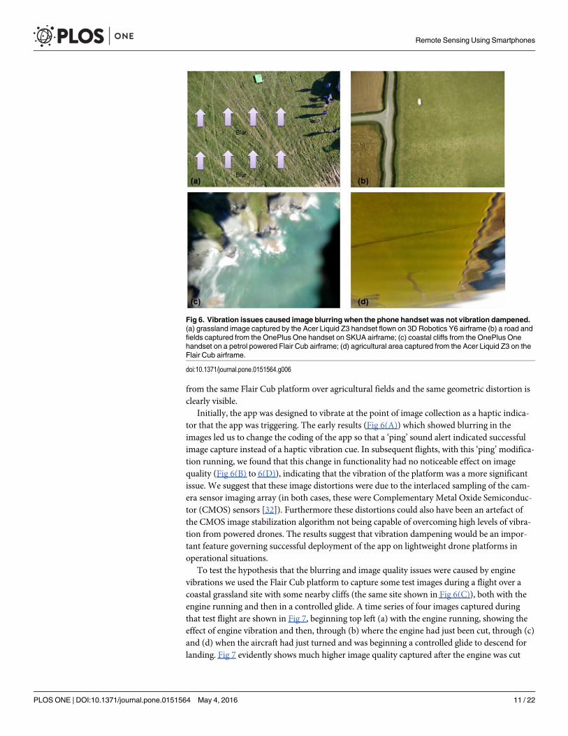
from the same Flair Cub platform over agricultural fields and the same geometric distortion isclearly visible.
Initially, the app was designed to vibrate at the point of image collection as a haptic indica-tor that the app was triggering. The early results (Fig 6(A)) which showed blurring in theimages led us to change the coding of the app so that a ‘ping’ sound alert indicated successfulimage capture instead of a haptic vibration cue. In subsequent flights, with this ‘ping’modifica-tion running, we found that this change in functionality had no noticeable effect on imagequality (Fig 6(B) to 6(D)), indicating that the vibration of the platform was a more significantissue. We suggest that these image distortions were due to the interlaced sampling of the cam-era sensor imaging array (in both cases, these were Complementary Metal Oxide Semiconduc-tor (CMOS) sensors [32]). Furthermore these distortions could also have been an artefact ofthe CMOS image stabilization algorithm not being capable of overcoming high levels of vibra-tion from powered drones. The results suggest that vibration dampening would be an impor-tant feature governing successful deployment of the app on lightweight drone platforms inoperational situations.
To test the hypothesis that the blurring and image quality issues were caused by enginevibrations we used the Flair Cub platform to capture some test images during a flight over acoastal grassland site with some nearby cliffs (the same site shown in Fig 6(C)), both with theengine running and then in a controlled glide. A time series of four images captured duringthat test flight are shown in Fig 7, beginning top left (a) with the engine running, showing theeffect of engine vibration and then, through (b) where the engine had just been cut, through (c)and (d) when the aircraft had just turned and was beginning a controlled glide to descend forlanding. Fig 7 evidently shows much higher image quality captured after the engine was cut
Fig 6. Vibration issues caused image blurring when the phone handset was not vibration dampened.(a) grassland image captured by the Acer Liquid Z3 handset flown on 3D Robotics Y6 airframe (b) a road andfields captured from the OnePlus One handset on SKUA airframe; (c) coastal cliffs from the OnePlus Onehandset on a petrol powered Flair Cub airframe; (d) agricultural area captured from the Acer Liquid Z3 on theFlair Cub airframe.
doi:10.1371/journal.pone.0151564.g006
Remote Sensing Using Smartphones
PLOS ONE | DOI:10.1371/journal.pone.0151564 May 4, 2016 11 / 22

((c) and (d)). The linear features of the road and the detail in the cliff structures are much moreclearly discernible and the images have greater geometric clarity without the distortions to lin-ear features previously evident in Fig 6(B), for example. Using the straight edge of the piece ofblack tape that partially covered the lower right hand part of the lens as a secondary guide it ispossible to see from Fig 7 that the photographs captured whilst gliding (7(c) and (d)) sufferedless distortion than those captured when the engine was running (7(a)). Fig 8 provides twophotographs (with zoom areas shown beneath) collected by the OnePlus One phone whenflown on the Quanum nova quadcopter. Here, we sought a low-cost option to dampen vibra-tions, placing a kitchen sponge (as shown in Fig 2(C)) between the phone and the aircraftunderside to absorb vibrations. Whilst some image quality issues remained (blur is evident inthe zoomed area in (b)), the overall mapping capability of the phone on this low cost platformappeared good and certainly typical results were improved (e.g. zoomed area in (a)) over theblurry examples shown in Figs 6 and 7.
Results from kite platforms. Results from tests on kite platforms were also informativeand helped to define the operational limits of the app. For all kite tests, the OnePlus One hand-set was used. Fig 9 shows early results from the Flexifoil stunt kite (fixing shown in Fig 2(A)).In Fig 9(A) an image collected over a sandy beach (with the sea on the left of the image and thebeach on the right). Here, the impact of kite vibrations was very clear–the conditions on theday of this flight were windy, with gusts up to 20 miles per hour, and coupled with the woodenjig which restricted pilot control over the kite, we found that the platform was not ideal foraerial photography, and that the app was unable to cope well with the highly variable condi-tions. Despite this, some useable images were captured from the Flexifoil platform–Fig 9(B)
Fig 7. Results of an in-flight experiment to test the impact of engine vibration on image quality using theOnePlus One phone and the Flair Cub platform when (a) the engine was running, (b) the engine had justbeen turned off and (c), (d) when the aircraft was gliding and vibration distortions were minimised. The black‘edge’ shown bottom right was a piece of tape used to fix the phone in place on the aircraft, and was alsoused as a constant visual guide for the level of image distortion encountered in the different scenarios. Theedge gets sharper as the engine is turned off and the aircraft is switched to gliding mode.
doi:10.1371/journal.pone.0151564.g007
Remote Sensing Using Smartphones
PLOS ONE | DOI:10.1371/journal.pone.0151564 May 4, 2016 12 / 22

Fig 8. Example images over a mixed grassland/woodland site collected by the OnePlus One phonefixed to the QuanumNova quadcopter where vibration dampening was achieved using a kitchensponge between the phone handset and the aircraft (see Fig 2(C)). (a) is an area of grass bordered bytrees and (b) shows the flight crew on the ground. Below (a) and (b) are two areas of focus, showing (a) goodquality data with minimal blurring over a patch of trees and (b) evidence of some blurring in an imagecollected over the flight team (all co-authors of this paper).
doi:10.1371/journal.pone.0151564.g008
Fig 9. Results from a Flexifoil kite where the OnePlus One phone was attached to the wooden jigshown in Fig 2(A). (a) Shows the impact of high winds and vibration over a sand and sea scene, and (b)shows a clearer image captured from an off-nadir geometry of one of the authors and a cross-hair targetcarved into the sand.
doi:10.1371/journal.pone.0151564.g009
Remote Sensing Using Smartphones
PLOS ONE | DOI:10.1371/journal.pone.0151564 May 4, 2016 13 / 22
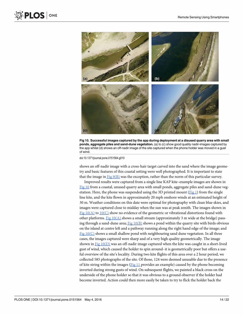
shows an off-nadir image with a cross-hair target carved into the sand where the image geome-try and basic features of this coastal setting were well photographed. It is important to statethat the image in Fig 9(B) was the exception, rather than the norm of this particular survey.
Improved results were captured from a single line KAP kite–example images are shown inFig 10 from a coastal, unused quarry area with small ponds, aggregate piles and sand-dune veg-etation. Here, the phone was suspended using the 3D printed mount (Fig 1) from the singleline kite, and the kite flown in approximately 20 mph onshore winds at an estimated height of30 m. Weather conditions on this date were optimal for photography with clean blue skies, andimages were captured close to midday when the sun was at peak zenith. The images shown inFig 10(A) to 10(C) show no evidence of the geometric or vibrational distortions found withother platforms. Fig 10(A) shows a small stream (approximately 3 m wide at the bridge) pass-ing through a sand-dune area; Fig 10(B) shows a pond within the quarry site with birds obviouson the island at centre left and a pathway running along the right hand edge of the image; andFig 10(C) shows a small shallow pond with neighbouring sand dune vegetation. In all threecases, the images captured were sharp and of a very high quality geometrically. The imageshown in Fig 10(D) was an off-nadir image captured when the kite was caught in a short-livedgust of wind, which caused the holder to spin around–it is geometrically poor but offers a use-ful overview of the site’s locality. During two kite flights of this area over a 2 hour period, wecollected 585 photographs of the site. Of those, 124 were deemed unusable due to the presenceof kite string within the images (Fig 11 provides an example) caused by the phone becominginverted during strong gusts of wind. On subsequent flights, we painted a black cross on theunderside of the phone holder so that it was obvious to a ground observer if the holder hadbecome inverted. Action could then more easily be taken to try to flick the holder back the
Fig 10. Successful images captured by the app during deployment at a disused quarry area with smallponds, aggregate piles and sand-dune vegetation. (a) to (c) show good quality nadir-images captured bythe app whilst (d) shows an off-nadir image of the site captured when the phone holder was moved in a gustof wind.
doi:10.1371/journal.pone.0151564.g010
Remote Sensing Using Smartphones
PLOS ONE | DOI:10.1371/journal.pone.0151564 May 4, 2016 14 / 22

right way, or bring the kite down so that a re-launch could be achieved with the phone in theright geometry.
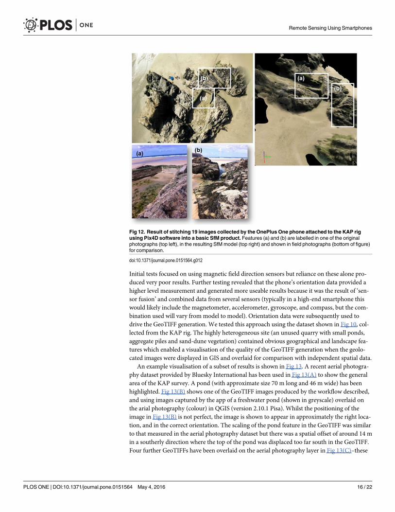
Finally a series of test flights with the same KAP rig over a rocky coastal outcrop wereundertaken, resulting in the data shown in Fig 12. A total of 19 crisp images were capturedover the main rocky outcrop shown in the top left image in Fig 12 (example KAP photographcaptured by the app) in gusty winds up to 25 mph from an approximate height of 30 m. Theseimages were tested within Pix4D (commercial software for image stitching and for ‘structurefrom motion’ (SfM) model generation [33–35]) to determine whether they could be used toproduce a useful spatial model of this coastal feature. The resultant 3D model (taking less than20 minutes processing time on a standard windows 64bit desktop PC) is shown visually on theright of Fig 12. Areas labelled (a) and (b) are shown as photographed from the ground, (a) is atidal swimming pool with a concrete wall and (b) is a natural crack in the rock platform with adistinctive structure. Whilst we have not quantitatively evaluated the quality of the SfM prod-uct, it is clear from visual assessment of the constructed model that these features are reason-ably well represented in the resultant model. This is the first time that SfM has beendemonstrated to work with images captured from a mobile phone using an autonomously trig-gered app, and flown on a KAP rig.
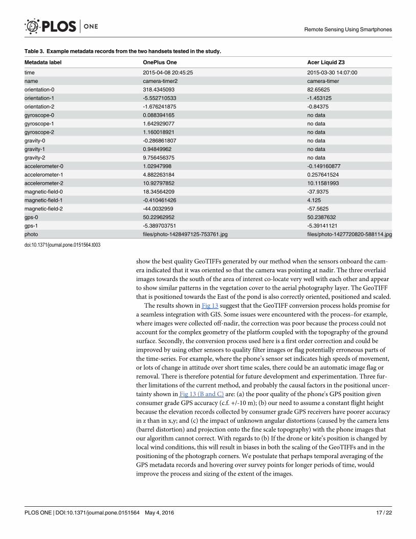
Results of GeoTIFF processing using phone-gathered metadata. Example metadata asstored in the SQLite database and collected by each of the two test handsets are shown inTable 3 for two separate acquisitions. Note that the sensor set available for the Acer handsetwas much reduced compared to the higher specification OnePlus One handset.
The process of automatically converting the photographs into GIS-ready GeoTIFFs was notstraightforward and required several iterations before an acceptable translation was achieved.We evaluated which of the phone’s sensors were most useful for performing the conversion.
Fig 11. Example ‘kite line’ image captured with the OnePlus One phone from the KAP rig when thephone holder became inverted during a gust of wind.
doi:10.1371/journal.pone.0151564.g011
Remote Sensing Using Smartphones
PLOS ONE | DOI:10.1371/journal.pone.0151564 May 4, 2016 15 / 22
Initial tests focused on using magnetic field direction sensors but reliance on these alone pro-duced very poor results. Further testing revealed that the phone’s orientation data provided ahigher level measurement and generated more useable results because it was the result of ‘sen-sor fusion’ and combined data from several sensors (typically in a high-end smartphone thiswould likely include the magnetometer, accelerometer, gyroscope, and compass, but the com-bination used will vary from model to model). Orientation data were subsequently used todrive the GeoTIFF generation. We tested this approach using the dataset shown in Fig 10, col-lected from the KAP rig. The highly heterogeneous site (an unused quarry with small ponds,aggregate piles and sand-dune vegetation) contained obvious geographical and landscape fea-tures which enabled a visualisation of the quality of the GeoTIFF generation when the geolo-cated images were displayed in GIS and overlaid for comparison with independent spatial data.
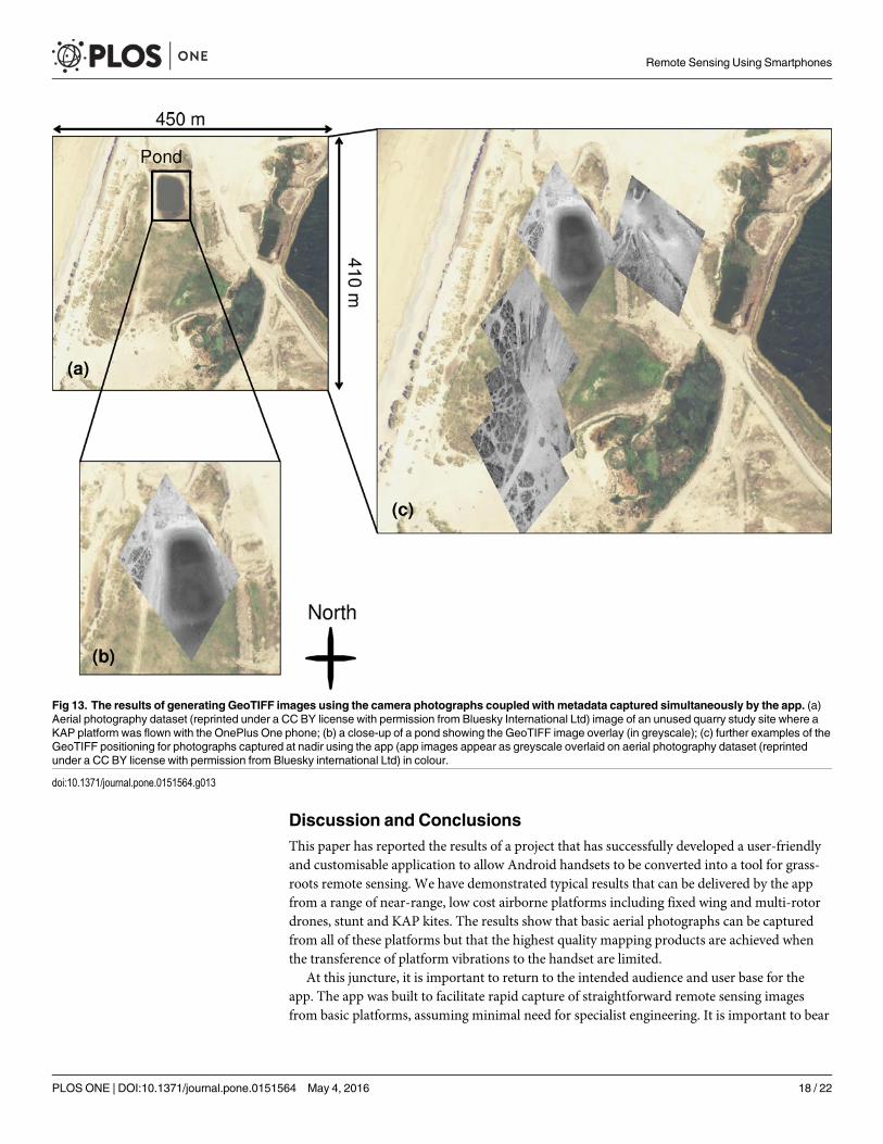
An example visualisation of a subset of results is shown in Fig 13. A recent aerial photogra-phy dataset provided by Bluesky International has been used in Fig 13(A) to show the generalarea of the KAP survey. A pond (with approximate size 70 m long and 46 m wide) has beenhighlighted. Fig 13(B) shows one of the GeoTIFF images produced by the workflow described,and using images captured by the app of a freshwater pond (shown in greyscale) overlaid onthe arial photography (colour) in QGIS (version 2.10.1 Pisa). Whilst the positioning of theimage in Fig 13(B) is not perfect, the image is shown to appear in approximately the right loca-tion, and in the correct orientation. The scaling of the pond feature in the GeoTIFF was similarto that measured in the aerial photography dataset but there was a spatial offset of around 14 min a southerly direction where the top of the pond was displaced too far south in the GeoTIFF.Four further GeoTIFFs have been overlaid on the aerial photography layer in Fig 13(C)–these
Fig 12. Result of stitching 19 images collected by the OnePlus One phone attached to the KAP rigusing Pix4D software into a basic SfM product. Features (a) and (b) are labelled in one of the originalphotographs (top left), in the resulting SfM model (top right) and shown in field photographs (bottom of figure)for comparison.
doi:10.1371/journal.pone.0151564.g012
Remote Sensing Using Smartphones
PLOS ONE | DOI:10.1371/journal.pone.0151564 May 4, 2016 16 / 22
show the best quality GeoTIFFs generated by our method when the sensors onboard the cam-era indicated that it was oriented so that the camera was pointing at nadir. The three overlaidimages towards the south of the area of interest co-locate very well with each other and appearto show similar patterns in the vegetation cover to the aerial photography layer. The GeoTIFFthat is positioned towards the East of the pond is also correctly oriented, positioned and scaled.
The results shown in Fig 13 suggest that the GeoTIFF conversion process holds promise fora seamless integration with GIS. Some issues were encountered with the process–for example,where images were collected off-nadir, the correction was poor because the process could notaccount for the complex geometry of the platform coupled with the topography of the groundsurface. Secondly, the conversion process used here is a first order correction and could beimproved by using other sensors to quality filter images or flag potentially erroneous parts ofthe time-series. For example, where the phone’s sensor set indicates high speeds of movement,or lots of change in attitude over short time scales, there could be an automatic image flag orremoval. There is therefore potential for future development and experimentation. Three fur-ther limitations of the current method, and probably the causal factors in the positional uncer-tainty shown in Fig 13 (B and C) are: (a) the poor quality of the phone's GPS position givenconsumer grade GPS accuracy (c.f. +/-10 m); (b) our need to assume a constant flight heightbecause the elevation records collected by consumer grade GPS receivers have poorer accuracyin z than in x,y; and (c) the impact of unknown angular distortions (caused by the camera lens(barrel distortion) and projection onto the fine scale topography) with the phone images thatour algorithm cannot correct. With regards to (b) If the drone or kite’s position is changed bylocal wind conditions, this will result in biases in both the scaling of the GeoTIFFs and in thepositioning of the photograph corners. We postulate that perhaps temporal averaging of theGPS metadata records and hovering over survey points for longer periods of time, wouldimprove the process and sizing of the extent of the images.
Table 3. Example metadata records from the two handsets tested in the study.
Metadata label OnePlus One Acer Liquid Z3
time 2015-04-08 20:45:25 2015-03-30 14:07:00
name camera-timer2 camera-timer
orientation-0 318.4345093 82.65625
orientation-1 -5.552710533 -1.453125
orientation-2 -1.676241875 -0.84375
gyroscope-0 0.088394165 no data
gyroscope-1 1.642929077 no data
gyroscope-2 1.160018921 no data
gravity-0 -0.286861807 no data
gravity-1 0.94849962 no data
gravity-2 9.756456375 no data
accelerometer-0 1.02947998 -0.149160877
accelerometer-1 4.882263184 0.257641524
accelerometer-2 10.92797852 10.11581993
magnetic-field-0 18.34564209 -37.9375
magnetic-field-1 -0.410461426 4.125
magnetic-field-2 -44.0032959 -57.5625
gps-0 50.22962952 50.2387632
gps-1 -5.389703751 -5.39141121
photo files/photo-1428497125-753761.jpg files/photo-1427720820-588114.jpg
doi:10.1371/journal.pone.0151564.t003
Remote Sensing Using Smartphones
PLOS ONE | DOI:10.1371/journal.pone.0151564 May 4, 2016 17 / 22
Discussion and ConclusionsThis paper has reported the results of a project that has successfully developed a user-friendlyand customisable application to allow Android handsets to be converted into a tool for grass-roots remote sensing. We have demonstrated typical results that can be delivered by the appfrom a range of near-range, low cost airborne platforms including fixed wing and multi-rotordrones, stunt and KAP kites. The results show that basic aerial photographs can be capturedfrom all of these platforms but that the highest quality mapping products are achieved whenthe transference of platform vibrations to the handset are limited.
At this juncture, it is important to return to the intended audience and user base for theapp. The app was built to facilitate rapid capture of straightforward remote sensing imagesfrom basic platforms, assuming minimal need for specialist engineering. It is important to bear
Fig 13. The results of generating GeoTIFF images using the camera photographs coupled with metadata captured simultaneously by the app. (a)Aerial photography dataset (reprinted under a CC BY license with permission from Bluesky International Ltd) image of an unused quarry study site where aKAP platform was flown with the OnePlus One phone; (b) a close-up of a pond showing the GeoTIFF image overlay (in greyscale); (c) further examples of theGeoTIFF positioning for photographs captured at nadir using the app (app images appear as greyscale overlaid on aerial photography dataset (reprintedunder a CC BY license with permission from Bluesky international Ltd) in colour.
doi:10.1371/journal.pone.0151564.g013
Remote Sensing Using Smartphones
PLOS ONE | DOI:10.1371/journal.pone.0151564 May 4, 2016 18 / 22
in mind that most scientific users wanting high quality radiometric or spatial data from kite ordrone platforms would be unlikely to use a mobile phone as their main imaging device. Thetarget audience for the app is much broader than this–it is intended for use in teaching, or incommunity led mapping, or in settings where a quick ‘start-up’ for a remote sensing study isneeded. For example in humanitarian crisis situations where basic survey data are required toinform emergency relief efforts, it is not necessary to have high quality radiometric data–instead, simple images that inform rescuers or aid workers of the location of stranded people,damaged property or flooded land would be perfectly adequate. Equally, in the aftermath of anearthquake or flood, the app would be very capable of delivering aerial imaging products thatwould allow the identification of damaged features or impacted areas. When thinking aboutthe app’s potential uses in these situations, it is important to reflect on the field of ‘appropriatetechnology’ [20]–anyone with an Android handset and a platform to allow that phone handsetto get airborne can now use this app to collect geotagged aerial images for basic spatial datacapture and mapping. The work presented in this paper provides evidence that the app pro-vides a freely available tool for open source spatial data capture.
Looking at the quality of results generated by the app, we found that the best results weregathered from a KAP rig costing less than £100, where the OnePlus One phone was suspendedusing a 3D printed plate suspended from the single line of the kite. On motorised platforms themain data quality issue was caused by systematic distortions in the images caused by interfer-ence between the imaging sensor and the vibrations of the motor. Both of the mobile phonemodels tested used the popular CMOS image sensor due to their lightweight, small size andlow power consumption [32,36]. One drawback of CMOS sensors is their use of a rolling shut-ter, whereby a line scanning approach is used to capture an image, meaning that every pixel isnot imaged at exactly the same time, increasing the chances of blur due to motion [37]. Thisrisk of blurring is apparent in many of the photographs collected when the platform velocitywas high or when high frequency vibrations were present. The results indicate that there is arequirement to provide adequate vibration dampening, flight planning or change in vehiclecontrol to mitigate for this. We have shown that it is possible to successfully dampen the vibra-tions caused by drone motors during flight using very basic equipment (here, we used a kitchensponge between the phone and the Quanum Nova multirotor aircraft), but this did not removeall vibrational effects. On a single line kite platform the vibrational effects were not visible inmost of the photographs captured, indicating that this offered a more stable platform for imagecapture with CMOS-camera equipped mobile phones. For high quality mapping from a droneplatform, we suggest that the phone would need a more sophisticated vibration-dampenedmounting plate. Other grassroots approaches point to a solution where the phone could behung from the underside of an aircraft or kite using a wooden plate suspended by piano wiresfor vibration absorption–but doing this requires access to appropriate engineering capabilitiesand materials, which in some of the situations where this app is intended for use, may not beavailable. This technique was used by George R. Lawrence for his early aerial photographywork from kites [38] but has also been explored in drones as a low cost way of suspending cam-eras and reducing vibration effects [39,40]. There are changes on the horizon with smartphonemanufacturers starting to use different camera sensors within their handsets. For example,Sony have just released a stacked CMOS image sensor with built-in hybrid autofocus and3-axis electronic image stabilization which may reduce the impacts of platform vibration effectsin the future [41].
Critically to its flexible use, the visual coding ‘scheme bricks’ approach used to design andlive-code the app will allow end-users to customise their own data acquisition and to a certainextent, to control image quality (e.g. by limiting the conditions under which the camera is trig-gered to capture a photograph). The live coding capability provides great flexibility for
Remote Sensing Using Smartphones
PLOS ONE | DOI:10.1371/journal.pone.0151564 May 4, 2016 19 / 22

successful deployment on a wide range of Android handsets. We have demonstrated the use ofopen-source GDAL tools to convert the high quality jpeg images captured by the phone camerainto GeoTIFF images for direct use in GIS software, and shown the limitations of the approachas it relies on uncertain GPS positional information and height data.
The recent global expansion of the lightweight consumer drone market, the globally ubiqui-tous availability of kites and mobile phones, and a growing social appetite for open-source, freeto use mapping data means that there is now a great opportunity for this app to be put to greatuse in democratic and participatory mapping exercises. Anyone in the world with an androidhandset and access to a vertical space (from a kite, drone or even from a rooftop or terracelooking down) where nadir Earth-focused imaging can be captured can now use this app togenerate new fine-grained mapping products. The app can be downloaded freely from theGoogle store by searching for ‘UAV-toolkit’ [42], and all code is open source and availablefrom [31]. We appreciate any feedback that users provide.
AcknowledgmentsFunding for the project to develop and test the app was provided by the European Social Fundand the NERC Impact Accelerator Fund and awarded to Dr Karen Anderson and David Grif-fiths. The aircraft and kite systems used were supplied by the Environment and SustainabilityInstitute DroneLab at the University of Exeter, which Karen Anderson leads. We are gratefulto various field helpers, specifically C. Anderson, P. Shutler and O. Griffiths.
Copyright and privacy. All photographs and images in this paper were collected by the co-authors of this paper so there are no reproduction issues. All photographs showing peopledepict the co-authors so there are no privacy or consent issues. The individuals shown in pho-tographs in this manuscript have all given written informed consent (as outlined in PLOS con-sent form) to publish.
Author ContributionsConceived and designed the experiments: KA DG LD. Performed the experiments: KA DG LDJDS JPDWR AG SH. Analyzed the data: DG KA LD JPD. Contributed reagents/materials/analysis tools: DG AG KA. Wrote the paper: KA DG LD JDS JPDWR AG SH.
References1. Lane ND, Miluzzo E, Lu H, Peebles D, Choudhury T, et al. (2010) A Survey of Mobile Phone Sensing.
Ieee Communications Magazine 48: 140–150.
2. Raento M, Oulasvirta A, Eagle N (2009) Smartphones An Emerging Tool for Social Scientists. Socio-logical Methods & Research 37: 426–454.
3. Deville P, Linard C, Martin S, Gilbert M, Stevens FR, et al. (2014) Dynamic population mapping usingmobile phone data. Proceedings of the National Academy of Sciences 111: 15888–15893.
4. Aanensen DM, Huntley DM, Feil EJ, al-Own F, Spratt BG (2009) EpiCollect: Linking Smartphones toWeb Applications for Epidemiology, Ecology and Community Data Collection. Plos One 4.
5. Teacher AGF, Griffiths DJ, Hodgson DJ, Inger R (2013) Smartphones in ecology and evolution: a guidefor the app-rehensive. Ecology and Evolution 3: 5268–5278. doi: 10.1002/ece3.888 PMID: 24455154
6. Cao TT, Thompson JE (2014) Remote Sensing of Atmospheric Optical Depth Using a Smartphone SunPhotometer. Plos One 9.
7. Burdette SD, Herchline TE, Oehler R (2008) Practicing medicine in a technological age: Using smart-phones in clinical practice. Clinical Infectious Diseases 47: 117–122. doi: 10.1086/588788 PMID:18491969
8. Kirwan M, Duncan MJ, Vandelanotte C, MummeryWK (2012) Using Smartphone Technology to Moni-tor Physical Activity in the 10,000 Steps Program: A Matched Case-Control Trial. Journal of MedicalInternet Research 14.
Remote Sensing Using Smartphones
PLOS ONE | DOI:10.1371/journal.pone.0151564 May 4, 2016 20 / 22
9. Anderson K, Gaston KJ (2013) Lightweight unmanned aerial vehicles will revolutionize spatial ecology.Frontiers in Ecology and the Environment 11: 138–146.
10. Bryson M, Johnson-Roberson M, Murphy RJ, Bongiorno D (2013) Kite Aerial Photography for Low-Cost, Ultra-high Spatial Resolution Multi-Spectral Mapping of Intertidal Landscapes. Plos One 8.
11. Murray JC, Neal MJ, Labrosse F (2013) Development and Deployment of an Intelligent Kite Aerial Pho-tography Platform (iKAPP) for Site Surveying and Image Acquisition. Journal of Field Robotics 30:288–307.
12. Tuna G, Nefzi B, Conte G (2014) Unmanned aerial vehicle-aided communications system for disasterrecovery. Journal of Network and Computer Applications 41: 27–36.
13. Goodchild M (2007) Citizens as sensors: the world of volunteered geography. GeoJournal 69: 211–221.
14. Haklay M, Weber P (2008) OpenStreetMap: User-Generated Street Maps. Pervasive Computing, IEEE7: 12–18.
15. Dandois JP, Ellis EC (2010) Remote Sensing of Vegetation Structure Using Computer Vision. RemoteSensing 2: 1157–1176.
16. Dandois JP, Ellis EC (2013) High spatial resolution three-dimensional mapping of vegetation spectraldynamics using computer vision. Remote Sensing of Environment 136: 259–276.
17. James MR, Robson S (2014) Mitigating systematic error in topographic models derived from UAV andground-based image networks. Earth Surface Processes and Landforms 39: 1413–1420.
18. Zahawi RA, Dandois JP, Holl KD, Nadwodny D, Reid JL, et al. (2015) Using lightweight unmannedaerial vehicles to monitor tropical forest recovery. Biological Conservation 186: 287–295.
19. Gottschalk TK, Aue B, Hotes S, Ekschmitt K (2011) Influence of grain size on species-habitat models.Ecological Modelling 222: 3403–3412.
20. Appropedia (2015) Appropedia: the site for collaborative solutions in sustainability, poverty reductionand international development through the use of sound principles and appropriate technology http://www.appropedia.org/Welcome_to_Appropedia. Accessed 12/08/2015.
21. IDC (2015) Smartphone OSMarket Share, 2015 Q2. http://www.idc.com/prodserv/smartphone-os-market-share.jsp. Accessed 20 October 2015.
22. Field Photo (2016) Google Play Store location for the ‘Field Photo’ app. https://play.google.com/store/apps/details?id=com.eomf&hl=en. Accessed 19 February 2016.
23. GeoWiki Pictures (2016) Google Play Store location for the ‘GeoWiki Pictures’ app. http://www.geo-wiki.org/mobile-apps/. Accessed 19 February 2016.
24. Paterno F (2013) End User Development: Survey of an Emerging Field for Empowering People. ISRNSoftware Engineering 2013: 11.
25. Collins N, McLean A, Rohrhuber J, Ward A (2003) Live coding in laptop performance. Org Sound 8:321–330.
26. Magnusson T (2011) Algorithms as Scores: Coding Live Music. Leonardo Music Journal -: 19–23.
27. Rubin MJ (2013) The effectiveness of live-coding to teach introductory programming. Proceeding of the44th ACM technical symposium on Computer science education. Denver, Colorado, USA:ACM. pp. 651–656.
28. Maclean A, Griffiths D, Collins N, Wiggins G (2010) Visualisation of live code. In: http://www.bcs.org/upload/pdf/ewic_ev10_s2paper1.pdf, editor. Electronic visualisation and the arts (EVA 2010). London,UK 5–7 July 2010.
29. Tinyscheme (2016) Tinyscheme interpreter. http://tinyscheme.sourceforge.net/. Accessed 19 February2016.
30. GDAL (2015) Geospatial Data Abstraction Library. http://gdal.org./ Accessed 12 August 2015.
31. Griffiths D (2015) GitHub repository and commit log https://github.com/nebogeo/uav-toolkit/commits/master. Accessed 12/08/2015.
32. Zhang M, Bermak A (2010) CMOS Image Sensor with On-Chip Image Compression: A Review andPerformance Analysis. Journal of Sensors 2010: 17.
33. Lucieer A, de Jong SM, Turner D (2014) Mapping landslide displacements using Structure fromMotion(SfM) and image correlation of multi-temporal UAV photography. Progress in Physical Geography 38:97–116.
34. Tonkin TN, Midgley NG, GrahamDJ, Labadz JC (2014) The potential of small unmanned aircraft sys-tems and structure-from-motion for topographic surveys: A test of emerging integrated approaches atCwm Idwal, North Wales. Geomorphology 226: 35–43.
Remote Sensing Using Smartphones
PLOS ONE | DOI:10.1371/journal.pone.0151564 May 4, 2016 21 / 22
35. Westoby MJ, Brasington J, Glasser NF, Hambrey MJ, Reynolds JM (2012) ‘Structure-from-Motion’ pho-togrammetry: A low-cost, effective tool for geoscience applications. Geomorphology 179: 300–314.
36. Litwiller D (2001) CCD vs. CMOS: Facts and fiction. Photonics Spectra 35: 154–158.
37. Ait-Aider O, Andreff N, Lavest J, Martinet P (2006) Simultaneous Object Pose and Velocity Computa-tion Using a Single View from a Rolling Shutter Camera. In: Leonardis A, Bischof H, Pinz A, editors.Computer Vision–ECCV 2006: Springer Berlin Heidelberg. pp. 56–68.
38. Baker S (1991) George R. Lawrence & his aerial photos. Naval History 5: 62.
39. Neuro (2013) Tri-copter scratch build on DIYDrones http://diydrones.com/group/arducopterusergroup/forum/topics/tri-copter-scrach-build. Accessed 26 August 2015.
40. FPV Oscar (2014) FPV Tricopter—PianoWire Camera Mount Test—Play with Dog. https://www.youtube.com/watch?v=GpkrScNI0hA. Accessed 26 August 2015.
41. Sony (2016) Exmor RS: Sony Announces a New Type 1/2.6 22.5 Megapixel Exmor RS™, the Indus-try's First Stacked CMOS Image Sensor with Built-in Hybrid Autofocus and 3-Axis Electronic Image Sta-bilization. http://www.sony.net/SonyInfo/News/Press/201602/16-013E/index.html. Accessed 19February 2016.
42. UAV Toolkit (2016) Google Play Store location for the ‘UAV toolkit’ app. https://play.google.com/store/apps/details?id=foam.uavtoolkit&hl=en. Accessed 19 February 2016.
Remote Sensing Using Smartphones
PLOS ONE | DOI:10.1371/journal.pone.0151564 May 4, 2016 22 / 22