Research Study - SMART Tbk
245
Research Study On the Social Impact of Oil Palm Plantation Development in Central and West Kalimantan Provinces The Faculty of Agriculture – Tanjungpura University The Faculty of Agriculture – University of Palangkaraya 28 June 2011
Transcript of Research Study - SMART Tbk

Research StudyOn the Social Impact of Oil Palm Plantation Developmentin Central and West Kalimantan Provinces
The Faculty of Agriculture – Tanjungpura UniversityThe Faculty of Agriculture – University of Palangkaraya
28 June 2011

Executive Summary
1
EXECUTIVE SUMMARY
1. Background
In the past, Greenpeace reports contained allegations that the “Sinar Mas Group”, among other issues, had caused social conflicts including land rights and resource conflicts through plantation expansion.
GAR’s subsidiary SMART is marketed under the Sinar Mas brand. However, GAR and SMART are not subsidiaries of Sinar Mas, as Sinar Mas does not refer to any operating business entity.
In response to the Greenpeace allegations, SMART appointed two leading certification bodies, the Control Union Certifications (CUC) and BSI Group, which collaborated with the Faculty of Forestry, Bogor Agricultural Institute (IPB) to conduct an Independent Verification Exercise (IVEX).
In relation to social issues, the IVEX Report published on 10 August 2010 concluded that:
There was no evidence of conflict over land acquisition process. However, there was also •no records of participatory discussions with previous land owners during the compensation process. There was no evidence that independent third parties were represented during discussions with land owners. Where there was evidence of meetings, it appeared that the attendees were SMART employees, land owners and sub-district heads (Camat) who witnessed compensation payment rather than being involved in negotiations. There was no clear evidence that land owners were provided with a cost-benefit analysis to compare the merits of owning the land or relinquishing it. Some land owners who did not relinquish their land rights were interviewed and they indicated that there was no undue pressure from SMART to relinquish their land
Interviews with the local community support the view that the plantations had a positive •impact on the community. There were references of improvements in infrastructure and livelihood. However, the number of interviews conducted could not adequately conclude that there was no negative social impact to the communities. The IVEX Team feels that for

Executive Summary
2
its observations to be conclusive, separate research needs to be done and recommends that SMART embarks on this.
SMART accepted the recommendations of the IVEX Report and agreed to conduct a more intensive study by commissioning a research team.
A research team was established, comprising researchers from the Faculty of Agriculture of Tanjungpura University in Pontianak, West Kalimantan Province and the Faculty of Agriculture of the University of Palangkaraya in Palangkaraya, Central Kalimantan Province.
This social research study was benchmarked against the three RSPO criteria used by the IVEX Team, covering the eight companies as per the IVEX report.
2. Problem Formulation
Based on the chronology of events described above, the problems to be addressed in this study were as follows:
(1) The RSPO Grievance Panel’s questions on whether the SOP of SMART adequately addresses RSPO Criteria 2.3, 7.5 and 7.6.
(2) The IVEX Report findings showed that there were gaps in meeting the RSPO Criteria 2.3, 7.5 and 7.6. Although the IVEX Report highlighted three criteria, the RSPO Grievance Panel agreed with SMART on the inclusion of Criterion 7.3, as Criterion 7.5 refers to Criterion 7.3.
3. Objectives
The objectives of the study were:
(1) To identify whether there was non-compliance and non-adherence of the SOP of SMART with RSPO Criteria 2.3, 7.3, 7.5 and 7.6.
(2) To identify whether there was non-compliance and non-adherence of field execution with the SOP of SMART.
(3) To identify social impacts of SMART operations on the surrounding communities, which are related to RSPO Criteria 2.3, 7.3, 7.5 and 7.6.
(4) To identify the compliance with Criterion 7.3 especially on the implementation of HCV5 and HCV6, in keeping with Criterion 7.5 which refers to new plantings.
(5) To recommend enhancements to the SOP of SMART with reference to RSPO Criteria 2.3, 7.3, 7.5 and 7.6.

Executive Summary
3
4. Methodology
4.1. Locations
The following eight companies were covered as per the IVEX report:
4.1.1. West Kalimantan Province
(1) PT Kartika Prima Cipta (KPC) located in Semitau and Nanga Suhaid Sub-districts of Kapuas Hulu District;
(2) PT Kencana Graha Permai (KGP) located in Marau Sub-district of Ketapang District; and
(3) PT Agrolestari Mandiri (ALM) located in Nanga Tayap Sub-district of Ketapang District.
4.1.2. Central Kalimantan Province
(1) PT Binasawit Abadi Pratama (BAP) located in Danau Sembuluh, Danau Saluluk and Batu Ampar Sub-districts of Seruyan District;
(2) PT Tapian Nadenggan (TN) located in Hanau, Danau Saluluk and Batu Ampar Sub-districts of Seruyan District;
(3) PT Satya Kisma Usaha (SKU) located in Arut Selatan and Pangkalan Lada Sub-districts of Kotawaringin Barat District;
(4) PT Mitrakarya Agroindo (MKA) located in Batu Ampar and Seruyan Tengah Sub-districts of Seruyan District; and
(5) PT Buana Adhitama (BAT) located in Bukit Sentuai, Mentaya Hulu and Antang Kalang Sub-districts of Kotawaringin Timur District.
4.2. Methods and Sources of Data Collection
(1) Focus group discussion (FGD). Participants in the discussion were: (1) plasma farmers; and (2) non-plasma communities. Plasma farmers are members of the local community who enter into a plasma scheme with the Company. Non-plasma communities are members of the local community who do not join the plasma scheme with the Company; they may include farmers, traders, shop owners, etc.
(2) In-depth interview. The Research Team conducted in-depth interviews with informal community leaders (adat or customary leaders and religious leaders, local traders, women and youths) in the concession area under study, as well as company leaders.

Executive Summary
4
(3) Structured interview. The Research Team conducted structured interviews with: (1) formal community leaders (sub-village/Dusun heads, village heads, village secretaries and sub-district heads or Camat and their officials); (2) District Plantation Guidance and Development Teams (3) Sub-district Plantation Guidance Task Forces; and (4) company representatives.
(4) Field observation. The Research Team made direct observations of subjects including environmental conditions, plantations, infrastructure, HCV areas and CSR projects.
(5) Collection of secondary data. The Research Team collected various data and documents from the Indonesian government (e.g. general statistics and company registration) and from the Company (e.g. company license, documentation of the Social and Environmental Impact Assessment (SEIA) process, SOP, reports of HCV Management and Monitoring, maps, etc.).
For the field study, three research teams from Tanjungpura University in Pontianak and five research teams from the University of Palangkaraya in Palangkaraya visited a total of 28 villages and conducted 32 FGDs, in-depth interviews with 136 informal leaders and structured interviews with 202 formal leaders, community individuals and company employees. The field visits were made during the months of November 2010–March 2011.
5. Important Findings
The following findings were extracted from the results of field study in the eight companies, comprising three companies in West Kalimantan Province and five companies in Central Kalimantan Province.
5.1. RSPO Criterion 2.3 – Use of land for oil palm does not diminish the legal rights, or customary rights, of other users, without their free, prior and informed consent
(1) Land acquisition by all eight companies under this study did not diminish the legal rights or customary rights of other users without their free, prior and informed consent. However, the negotiation process was not well recorded in writing.
At PT KGP in particular, the community members’ views on land ownership differed from
the Company’s. According to the Company, land that was not owned by any party at the beginning of land preparation in 2006 was state land, for which compensation was not required. But in 2009, some members of the local community claimed the state land was theirs and that the Company had not compensated them for it. The case is still in the process of settlement.

Executive Summary
5
(2) There is no map of traditional land with appropriate scale that shows areas under customary rights. For the purpose of negotiations, the Companies together with the land owner and the local village officials agreed to prepare land parcel maps which would be mutually agreed on.
(3) The final settlement between land owners and the Companies is documented in the final agreement signed by land owners, the respective companies, witnesses and acknowledged by village heads and sub-district heads. Copies of the final agreement are kept by the Companies and not distributed to land owners and other parties.
(4) The 2010 SOP of SMART mentions socialisation in the SOP on Land Use Title Acquisition Process and SOP on Land Compensation but does not describe it in detail. The Research Team recommends that the SOP should be adapted to clearly describe the process for socialisation that will be used, the information and materials to be provided to the parties involved, the process of discussion and agreement, as well as the proper documentation of the entire socialisation process.
5.2. RSPO Criterion 7.3 – New plantings since November 2005, have not replaced primary forest or any area required to maintain or enhance one or more High Conservation Values
(1) Land preparation for plantation development in the eight companies was not carried out in primary forest but in secondary forest, degraded land, shrub land, former logging sites or forest concessions, land previously cleared by natural fire and land left by shifting cultivators. Especially for plantations in West Kalimantan, the locations of the plantations have met the requirements set forth in the spatial planning, being located in Area for Other Uses. Such practice was in line with the Decree of the Minister of Forestry and Plantation No. 259/Kpts-11/2000 on Designation of Forest and Aquatic Areas. As for Central Kalimantan Province, the location refers to the Provincial Regulation No. 8 of 2003 on the Provincial Spatial Planning of Central Kalimantan and is located in the Production Development Area or Area for Settlement and Other Use.
(2) There was no map of land preparation in accordance with identified HCV areas, during the planning and implementation stages. Part of the land preparation and oil palm planting was conducted before HCV assessment as well as prior to the RSPO’s requirement to identify HCVs. All the companies carried out HCV assessments in early 2010, but by the time this study was conducted, not all final reports of the HCV assessments have been completed.
(3) The 2010 SOP of SMART for HCV Identification and Management does not explain each HCV clearly. The Research Team suggests that SOP be drawn up for individual HCVs, as each requires different management and monitoring measures.

Executive Summary
6
5.3. HCV5 – Natural areas critical for meeting the basic needs of local people
All eight companies had already conducted HCV assessment. Areas of HCV5 were not found in the concessions of the five companies operating in Central Kalimantan, so an HCV5 management and monitoring plan is not required. In contrast, HCV5 areas were identified in the concessions of the three companies in West Kalimantan in the form of springs for the local communities and agricultural land to meet their basic needs. These companies have already developed their own HCV5 management and monitoring plan. The local Dayak and Malay populations recognise that they share a commitment with the companies to carry out various activities to protect HCV5 areas against destructive exploitation.
Today, local populations have become less dependent on foraging in the surrounding forest to fulfil their basic needs as most of their daily staples are available at affordable prices in local markets. Development of oil palm plantations in the areas under this study has become an important source of income for the local population, especially since previous sources of income such as logging are no longer capable of supporting the local economy. Most of the able males and females from surrounding communities work as labourers and contractors in various activities created by the plantation, such as loading and unloading, land preparation, planting, spraying and harvesting. Their communities also benefit from the multiplier effect of plantation operations.
5.4. HCV 6 – Areas critical for maintaining the cultural identity of local communities
HCV6 areas that were found in Central Kalimantan and West Kalimantan consist of sacred places and burial sites. The Companies have paid attention to HCV6 by managing burial sites and protecting sacred places against disturbance. However, some members of the community still claim that past land preparation trespassed on the burial sites of their ancestors. At PT KGP, for example, three burial sites were overrun by land preparation contractors, but all three had been reconstructed and reinstated with a simple religious ceremony.
5.5. RSPO Criterion 7.5 – No new plantings are established on local peoples’ land without their free, prior and informed consent, dealt with through a documented system that enables indigenous peoples, local communities and other stakeholders to express their views through their own representative institutions
(1) New plantings in all eight companies under this study were conducted with prior approval from the local people.
(2) It is a common practice that land owners are free to express their views on land acquisition and compensation payment. However, there is a lack of representative institutions that negotiate on behalf of individual land owners.

Executive Summary
7
(3) All the eight companies under the study already had an SEIA document, Environmental Management Plan and Environmental Monitoring Plan in their possession. The three documents were prepared by consultants and endorsed by the government, and the communities were engaged during their preparation. However, the monitoring report for the SEIA results is not yet complete, as it only reports the monitoring of water quality and does not cover socio-economic aspects.
(4) The Companies had already conducted socialisation prior to commencing operations, but the socialisation process was not well documented. In addition, the materials for socialisation have not included a cost-benefit analysis that compares the merits of relinquishing the land for oil palm development versus retaining it for other uses.
(5) The final agreement on land relinquishment/compensation between land owners and the Companies are available. However, copies of the final agreement are kept by the Companies and not provided to land owners.
(6) The 2010 SOP for Land Compensation does not mention clearly whether land owners are allowed to select their own representative institutions to represent them in negotiations with the Company, although in practice land owners often appoint their relatives to represent them in negotiations. The Research Team suggests the statement “land owners are permitted to select their own representative institutions in negotiations with the Company” should be added to the SOP.
5.6. RSPO Criterion 7.6 – Local people are compensated for any agreed land acquisitions and relinquishment of rights, subject to their free, prior and informed consent and negotiated agreement
(1) The study found that identification and evaluation of land ownership based on legal and traditional land rights were already conducted. Compensation payment was discussed in negotiations between the Companies and traditional land owners witnessed by local government representatives. Although this negotiation process was not well documented, the final agreement was recorded in a land relinquishment statement kept by the Companies but not provided to land owners and other parties.
Individual land rights are determined in a number of ways: (1) Land Certificate issued by the National Land Agency; (2) Land Registration Form issued by Sub-district Head; (3) Land Registration Form issued by Village Head; and (4) Acknowledged Land Right. The last category of individual land right is determined by the express acknowledgement of the Village Head before witnesses who represent the land owner. If the individual land falls under the traditional right category, the acknowledgement from the Adat Chief and Village Head is required. When there is doubt about the claim, additional information can be collected from fellow villagers and neighbours of the land claimant.

Executive Summary
8
(2) The process for determining land compensation can be divided into the following steps: (1) receiving the express agreement of village representatives to relinquish the land; (2) identifying the size and location of the land as well as the cultivated plants; 3) clarifying the ownership with owners of the neighbouring land, community leaders who understand the land history, and the respective Village Head; (4) putting the results of identification in maps called peta rincik (land parcel map); and (5) negotiation of compensation with land owners or their representatives. The compensation amount paid to land owners varies from one company to another.
(3) Different negotiation methods were adopted: (1) The Company sets a range within which negotiation is made with due consideration of characteristics of the land including compensation for planted vegetation and negotiates with the land owners until an agreement is reached; (2) The Company sets the price and the land owners decide whether they agree to accept the offer or not; (3) The Company negotiates with the Village/Sub-district Head who represents land owners to determine land compensation in the village/sub-district and then negotiates with the land owners who decide whether to accept the offer or not.
There is a case in PT SKU where three land owners whose land had been cleared and planted are not willing to receive compensation that has been agreed before and demand that compensation be given in the form of land. This case is still in the process of settlement.
(4) Payment of compensation was made in cash. Proof of compensation payment consisted of a receipt attached to the final agreement, land release document, photograph and land parcel map. The final agreement and land release documents should be signed by representatives of the Company, land owners and witnesses, and acknowledged by the Village Head and Sub-district Head. All documents were kept by the Company and not disseminated to land owners and other parties.
(5) Villagers who no longer have access to and rights over land for oil palm plantation are given the opportunity to work at the Company, to provide services as local contractors and to join the plasma scheme.
(6) The 2010 SMART SOP for Land Compensation requires a land information letter as proof of land ownership. However, it does not specify the types of land information letter that are acceptable. To clarify, the Research Team suggests the use of “Land Registration Form issued by Sub-district Head or Village Head”.

Executive Summary
9
5.7. Social Impact Assessment
The presence of the Companies in the rural area creates positive impacts on surrounding areas, such as creating new jobs for the local community, increasing the local community’s income, increasing the circulation of cash in the rural market and stimulating the growth of businesses.
Road construction and maintenance have increased the accessibility of villages, the mobility of people and goods as well as improved connectivity between urban and rural areas, between towns and villages.
The study found changes related to social interaction, social structure and organisation, social institutions and social perception. There were concerns among local people in Central Kalimantan Province that the influx of outsiders might irreversibly alter their cultural identity. Furthermore, the study found that the structure and characteristics of the social elements are changing naturally, following the dynamics of development in the region and the nation.
The presence of oil palm development in the rural area, however, has introduced new variables in socio-economic development. Social goods that previously were passed around freely among members of the community without charge, e.g. land, labour and services, are now changing status into economic goods that require formal methods, procedures and economic value. Such transformations have been internalised by rural communities at different speed, hence creating challenges for some parts of the population.
Such changes, if not properly managed, can create social conflict, disrespect of sociocultural institutions and informal leaders, and a weakening of social solidarity. Therefore, the Companies should take an active role in managing social change and progress such as encouraging the establishment of a representative institution that can bridge the gap between the Companies and surrounding communities.
5.8. Corporate Social Responsibility (CSR)
The study found that the Companies had conducted various activities with their CSR projects in the sectors of infrastructure, health, education, disaster relief and local economy empowerment. Such activities can still be classified as ad-hoc in nature, and not as part of a well-planned, long-term and sustainable CSR programme which addresses strategic issues.
Some of the local communities told the Research Team that for many years they had faced problems collecting clean water. However, they did not consider the Companies the only cause of the problem, as many past activities such as logging and mining had also contributed. The local communities are hoping that the Companies as late-comers would make every effort to find a solution.

Executive Summary
10
In order to design CSR programmes which respond to the long-term needs of the communities and the Companies on a sustainable basis, the Research Team suggests that the Companies formulates SOP on CSR programmes.
5.9. Plasma Estates for Local Communities
According to Article 11 Paragraph 1 of Decree of the Minister of Agriculture No. 26 of 2007 on Guidance for Plantation Permits, a company that owns a Plantation Business License or Plantation Business License type B is required to develop at least 20% of the total plantable areas as a plasma estate for local communities. In Central Kalimantan, plasma estates have not been established because the General Spatial Plan of Central Kalimantan Province has not been enacted by the government. Consequently, the locations of the plasma estates have yet to be determined and hence there are difficulties in getting bank financing.
In West Kalimantan Province, the Companies experience a different problem regarding the basis for plasma estates. The land owners insist that the 20% quota for plasma estate be developed inside areas under the Company’s Land Use Title while the Company has explained that the plasma estate should be established outside that area. This is in accordance with a circular issued by the Director General of Plantation Department, Ministry of Agriculture No. 396/02.140/31.1/07/207 dated 25 July 2007 on Interpretation of Article 11 Paragraph 1 of the Decree of the Minister of Agriculture No. 26 of 2007. This circular confirms that the 20% quota is to be developed outside areas under the Company’s Land Use Title. However, the community still does not accept that.
Another problem relates to what constitutes the total plantable area, of which 20% will be devoted to plasma estates. The Companies exclude HCV areas from the total plantable area, pursuant to Article 11 Paragraph 1 of the Decree of the Minister of Agriculture No. 26 of 2007. On the other hand, the community is of the view that the total plantable area should include all land that the Company receives from the community.
The incidence of boundary disputes between adjacent villages has also prevented the development of plasma estates. This is true for PT ALM, and the Company is still awaiting agreement between the villages involved in the disputes.
The study also found that there has been no standard guideline regarding development of plasma estates. Therefore, the Research Team suggests that the Company formulates SOP on Plasma Estate Establishment in reference with the Decree of the Minister of Agriculture No. 26 of 2007.
Particularly for Central Kalimantan, the Research Team suggests that the Company starts to prepare SOP on the development of the Plasma Estates while awaiting completion of the revised Provincial Spatial Planning of Central Kalimantan.

Executive Summary
11
5.10. Status of Plantation Labour
The study found that the Companies employ two types of labour: (1) non-permanent labourers; and (2) daily and monthly permanent labourers. Wages for non-permanent labourers are based on the Provincial/District minimum wage, whichever is higher. They are paid regularly, regardless of their length of service in the Company. Permanent labourers receive daily or monthly wages plus benefits such as free housing, electricity, clean water, medical service, worker’s insurance coverage and a monthly rice ration.
Some non-permanent labourers told the Research Team that they expected the Company to consider raising their wage above the standard wage rate, as food prices in rural plantation areas are higher than those in urban areas. Furthermore, income from other activities such as rubber tapping that require shorter working hours is already higher than the standard wage.
6. Profile of The Research Team
The Research Team was led by Syamsuni Arman and he was assisted by two supervisors, Sutarman Gafur for West Kalimantan and Salampak Dohong for Central Kalimantan.
6.1. West Kalimantan Province
6.1.1. Syamsuni Arman
This research team member is a Professor Emeritus in Public Administration at the Faculty of Social Sciences of Tanjungpura University in Pontianak and holds a BA in Public Administration (Lambungmangkurat University in Banjarmasin, 1965), Drs. in Public Administration (Tanjungpura University in Pontianak, 1978), MA in Anthropology/Human Ecology from (Rutgers University, USA, 1982) and PhD in Anthropology/Human Ecology (Rutgers University, USA, 1987). His international training experience includes, among others, UNESCO training in Human Ecology in Samarinda (1981) and international training in Human Rights in Oslo, Norway (2006). His experience includes international research cooperation with the Fulbright Foundation, New York Botanical Garden, WWF-Indonesia, International Timber Trade Organisation (ITTO), Japan International Corporation Agency (JICA). In addition to teaching in several universities, he has also worked as a social consultant in the forestry, mining and plantation sectors.

Executive Summary
12
This research team member holds a PhD in Soil Biology and Land Rehabilitation from the University of Western Australia (2003), a Master’s degree in Soil and Water Conservation from the University of Tennessee, USA (1991), and an undergraduate degree in Agronomy from the Faculty of Agriculture, Tanjungpura University in Pontianak (1985). His research experience includes pre-surveys for oil palm plantation in West Kalimantan since 1986, collaboration with JICA for development of a basic model for agricultural development in Singbebas (Singkawang, Bengkayang and Sambas) Area in 2002-2003, and leading a project for promoting people participation in the development of the West Kalimantan–East Malaysia border in 2004, a project supported by the Partnership (a national NGO) in Jakarta. He has also been a member of the West Kalimantan Research Board since 2002, and was appointed as Chairman of the West Kalimantan Food Security Board in 2009.
6.1.3. Riduansyah
This research team member holds a Master’s degree in Soil and Water Management from Brawijaya University, East Java (1994). For more than 15 years, he has been active as a community development expert in several sub-sectors of agriculture: traditional farmers, marine and coastal communities, agro-forestry and urban poverty programmes in West Kalimantan Province. He has been involved as an assessor of more than 100 documents for SEIA for oil palm plantation concessions, mining exploitation activities, timber estate and national forest estate in West Kalimantan Province. In the last ten years, he has participated in a variety of studies on public policy for local government (Sintang District, Sanggau District, Pontianak District, Ketapang District, Kayong Utara District and Bengkayang District), and collaborating with a number of international organisations, e.g. JICA, World Bank, and DANIDA (Denmark).
6.1.4. Nurjani
This research team member holds a Master’s degree in Agronomy from Ohio State University, USA (1996). He is the head of the Agronomy Study Programme at the Faculty of Agriculture of Tanjungpura University and a lecturer’s representative in the university senate. His research experience includes collaborating with district governments in West Kalimantan Province in formulating agricultural strategic planning. In 2005, he was involved in writing the blueprint for agriculture development in Ketapang District. As an agricultural expert, he was also involved in a number of SEIAs for oil palm plantation development in West Kalimantan Province.
6.1.2. Sutarman Gafur

Executive Summary
13
6.1.5. Abdul Hamid A. Yusra
This research team member holds a Master’s degree in Natural Resource and Environment Management from Bogor Agriculture Institute. His participation in training includes the following topics: (1) Agribusiness development through “Training for Facilitator of PPUPKR Cooperative Model; (2) Facilitator in plantation training; and Technical management and community assistance. His community services include: Implementation of PRA Method; and (2) Regional development. His research experience includes: (1) Master plan research for livestock development in North Kayong District; (2) Area development for Sebedang’s micro watershed; (3) Identification and inventory of ex-mining area; (4) Master plan for agro-politan area; (5) Preparation of priority watershed in West Kalimantan; and (6) Programme evaluation for livestock development in West Kalimantan.
6.1.6. Ibrahim Isytar
This research team member holds a Master’s degree in Agricultural Economics from New Mexico State University, Las Cruses, USA. He has experience in preparing SEIA documents for forestry companies.
6.1.7. Novira Kusrini
This research team member holds a Master’s degree in Agribusiness Management (2002) and a Doctorate in Agricultural Socio-economics (2009) from the Faculty of Agriculture, Gadjah Mada University, Yogyakarta. She has an AMDAL B certificate that qualifies her to lead the evaluation and writing of SEIA reports. She is a member of Bhakti Ilmuwan Research and Community Centre (BIRCC).
6.2. Central Kalimantan Province
6.2.1. Salampak Dohong
This research team member is responsible for the research study in Central Kalimantan. Dr. Salampak Dohong holds a PhD in Soil Sciences from Bogor Agricultural University (IPB) in 1999. He pursued his Masters degree as well as his undergraduate degree specialising in Soil Sciences from the Bogor Agricultural University (IPB) in 1993 and 1987 respectively. He is currently the Dean of the Faculty of Agriculture at the University of Palangkaraya as well as visiting lecturer at the Hokkaido University since 1999. Dr Salampak Dohong is also the Staff Consultant in Katingan and Gunung Mas districts in Central Kalimantan.

Executive Summary
14
6.2.2. Wilson Daud
This research team member holds a Master of Science degree in Management of Agribusiness from Gadjah Mada University, Yogyakarta (2002). He has conducted research into the socio-economic condition of communities within oil palm plantations.
6.2.3. Suharno
This research team member holds both a Master’s degree (1986) and a Doctorate (1997) in Agricultural Economics from Gadjah Mada University, Yogyakarta. He has conducted research into socio-economic conditions within and around companies. In 2010, he conducted a social research in collaboration with the Plantation Office of Central Kalimantan Province and the Faculty of Agriculture, University of Palangkaraya.
6.2.4. Tri Prajawahyudo
This research team member holds a Master of Science degree in Extension and Communication from Gadjah Mada University, Yogyakarta (2009). He has experience conducting research in land and plantation management, and is a member of Team of Experts on Watershed Management in an oil palm company.
6.2.5. Trisna Anggreini
This research team member holds a Master’s degree in Agricultural Socio-economics from Gadjah Mada University, Yogyakarta (2009). She has conducted studies into rubber plantations, upland rice, food provision for a peat area community, profile of home industry, socio-economic empowerment of communities and the empowerment of women in the rattan industry.
6.2.6. Eddy Lion
This research team member holds Master’s and Doctorate degrees in Sociology from Merdeka University, Malang (2007). His research experience includes traditional production systems, traditional astronomy and meteorology, riparian areas of Central Kalimantan and the traditional Dayak marriage system.
6.2.7. Yuni Erlina
This research team member holds a Master’s degree in Agricultural Socio-economics from Gadjah Mada University, Yogyakarta (2010). She has conducted research into the local rubber industry, rice marketing strategies, economic analysis of farm household income, and economic analysis of high quality rice seeds in peat soil.

Executive Summary
15
6.2.8. Yusup Aguswan
This research team member holds a Master of Science degree in Geographic Information System from the Faculty of Geography, Gadjah Mada University, Yogyakarta (2008). He has been involved in SEIA and HCV assessment.
6.2.9. Yuprin A. Dehen
This research team member holds a Master of Agriculture degree from Brawijaya University, Malang (1993). His research experience includes a study of legal compliance in big plantation companies in Central Kalimantan and a social impact assessment of a plantation company in Kotawaringin Barat District.
6.2.10. Budya Satata
This research team member holds a Master of Science degree in Nutrition and Animal Feeds from Gadjah Mada University, Yogyakarta (1992). His research experience includes such topics as the nutritional value of kayambang (Salvinia auriculata), processing technology of rice stalks with ammonia as animal feeds, productivity of the nilam plant (Pogostemon Cablin Benth) in peat and red-yellow podzolic soils, and use of soluble plantation waste in relay cropping and intercropping of maize.
6.2.11. Yulianto
This research team member has an undergraduate degree in Development Economics from University of Palangkaraya (1988). His research experience includes socio-economic study of agricultural and plantation small businesses in Central Kalimantan, the role of upstream industries in the marketing of local rubber, and the effect of workforce mobility in wood processing.

Content
16
TABLE OF CONTENTS
EXECUTIVE SUMMARY ................................................................................................1TABLE OF CONTENTS ..............................................................................................16
1. INTRODUCTION ....................................................................................................171.1. Background ...........................................................................................................171.2. Problem Formulation .............................................................................................181.3. Objectives ..............................................................................................................181.4. Theoretical Framework ..........................................................................................191.5. Methodology ..........................................................................................................201.6. Research Teams and Academic Qualifications .....................................................231.7. Schedule of Study .................................................................................................25
2. LITERATURE REVIEW ...........................................................................................272.1. Forest Ecosystem ..................................................................................................272.2. Riparian Ecosystem...............................................................................................302.3. Free, Prior and Informed Consent (FPIC) .............................................................322.4. High Conservation Value (HCV) ............................................................................332.5. Oil Palm Plantation ................................................................................................352.6. Oil Palm Plantation Permit.....................................................................................362.7. Legal Rights and Traditional Rights .......................................................................382.8. Social Impact Assessment.....................................................................................402.9. Corporate Social Responsibility.............................................................................43
3. FIELD FINDINGS ....................................................................................................453.1. PT Kartika Prima Cipta (KPC) ...............................................................................453.2. PT Kencana Graha Permai (KGP) ........................................................................663.3. PT Agrolestari Mandiri (ALM) ................................................................................843.4. PT Binasawit Abadi Pratama (BAP) ....................................................................1083.5. PT Tapian Nadenggan (TN) .................................................................................1303.6. PT Satya Kisma Usaha (SKU) .............................................................................1503.7. PT Mitrakarya Agroindo (MKA) ............................................................................1663.8. PT Buana Adhitama (BAT) ..................................................................................186
4. CONCLUSION ......................................................................................................1994.1. Conclusion ...........................................................................................................2004.2. Recommendation ................................................................................................205
REFERENCES .......................................................................................................... 208GLOSSARY ...............................................................................................................213APPENDICES ...........................................................................................................219

Intoduction
17
1.1. Background
In the past, the Greenpeace reports contained allegations that the “Sinar Mas Group”, among other issues, had caused social conflicts including land rights and resource conflicts through plantation expansion.
GAR’s subsidiary SMART is marketed under the Sinar Mas brand. However, GAR and SMART are not subsidiaries of Sinar Mas, as Sinar Mas does not refer to any operating business entity.
In response to the Greenpeace allegations, SMART appointed two leading certification bodies, the Control Union Certifications (CUC) and BSI Group, which collaborated with the Faculty of Forestry, Bogor Agricultural Institute (IPB) to conduct an Independent Verification Exercise (IVEX).
In relation to social issues, the IVEX Report published on 10 August 2010 concluded that:
There was no evidence of conflict over land acquisition process. However, there was also •no records of participatory discussions with previous land owners during the compensation process. There was no evidence that independent third parties were represented during discussions with land owners. Where there was evidence of meetings, it appeared that the attendees were SMART employees, land owners and sub-district heads (Camat) who witnessed compensation payment rather than being involved in negotiations. There was no clear evidence that land owners were provided with a cost-benefit analysis to compare the merits of owning the land or relinquishing it. Some land owners who did not relinquish their land rights were interviewed and they indicated that there was no undue pressure from SMART to relinquish their land
Interviews with the local community support the view that the plantations had a positive •impact on the community. There were references of improvements in infrastructure and livelihood. However, the number of interviews conducted could not adequately conclude that there was no negative social impact to the communities. The IVEX Team feels that for
INTRODUCTION 1

Introduction
18
its observations to be conclusive, separate research needs to be done and recommends that SMART embarks on this.
SMART accepted the recommendations of the IVEX Report and agreed to conduct more intensive study by commissioning a Research Team.
A Research Team was established, comprising researchers from the Faculty of Agriculture of Tanjungpura University in Pontianak, West Kalimantan Province and the Faculty of Agriculture of the University of Palangkaraya in Palangkaraya, Central Kalimantan Province.
This social research was benchmarked against the three RSPO criteria used by the IVEX team, covering the eight concessions as per the IVEX report.
1.2. Problem Formulation
Based on the chronology of events described above and also the advice contained in the IVEX Report and the letter from the RSPO Grievance Panel, the problems to be addressed in this study were as follows:
(1) The IVEX findings indicated a gap between the implementation of corporate operations and RSPO Criteria 2.3, 7.5, and 7.6 and also Criterion 7.3. The IVEX report highlighted three criteria, but the RSPO Grievance Panel and PT SMART included Criterion 7.3 as Criterion 7.5 refers to Criterion 7.3.
(2) The RSPO questioned whether the SOP of SMART adequately addressed RSPO Criteria 2.3, 7.5, and 7.6.
1.3. Objectives
The objectives of the study were:(1) To identify whether there was non-compliance and non-adherence of the SOP of SMART
with RSPO Criteria 2.3, 7.3, 7.5 and 7.6.(2) To identify whether there was non-compliance and non-adherence of field execution with
the SOP of SMART.(3) To identify social impacts of SMART operations on the surrounding communities with
reference to RSPO Criteria 2.3, 7.3, 7.5 and 7.6. (4) To identify the compliance with criterion 7.3 especially on implementation of HCV5 and
HCV6, as Criterion 7.5 refers to new plantings.(5) To recommend enhancement to the SOP of SMART with reference to RSPO Criteria 2.3,
7.3, 7.5 and 7.6.

Intoduction
19
1.4. Theoretical Framework
Theoretically, this study attempts to provide field data and analysis on various aspects of SMART development of oil palm plantation in West Kalimantan and Central Kalimantan Provinces. The result will be useful for the Company to respond positively to the Grievance Panel’s complaint about the plantation performance. In order to achieve this objective, the study needs to look into various documents such as the RSPO Criteria particularly Criteria 2.3, 7.3, 7.5 and 7.6, the SOP of SMART, the IVEX Report and agreements on land acquisition between the Companies and local land owners.
Compliance to the above-mentioned criteria will be assessed through findings of the field study conducted throughout the areas of SMART in question. In appreciation of suggestions in the IVEX Report, SMART took the initiative to conduct the social research in collaboration with Faculty of Agriculture of Tanjungpura University in Pontianak and the Faculty of Agriculture of Palangkaraya University in Palangkaraya. In addition, as Criterion 7.5 refers to “new planting”, the study will also verify the compliance in relation to 7.3 specifically related to HCV5 and HCV6.
At the planning stage of this study, the relationship of all these components could only be predicted. The actual field conditions are described in Chapter 3: Field Findings. The relationship of various components covered in this study is summarised in Figure 1.1.
Figure 1.1. Correlation among components of the study
RSPOP&C2.3,
7.3,7.5,7.6SMARTnew
plantingSOP
Community’s
responses
Target
communities
Evaluationon
deviation
ImplementationofSMART
newplantingSOP&SEIAto
targetcommunities
Interpretationby
SMART
Studyonsocial
impact
Studyon
deviation2. ImprovedSMARTSOP
(conformingwith
RSPO)
3. Proposalon
mitigationofnegative
socialimpact
Scopeofthe
study
CentralKalimantan:SKU,
TN,MKA,BAP,BAT;and
WestKalimantan:KGP,
ALM,KPC
SEIA
study
deviation
social impact

Introduction
20
(1) PT Binasawit Abadi Pratama (BAP) located in Danau Sembuluh, Danau Seluluk and Batu Ampar sub-districts of Seruyan District;
(2) PT Tapian Nadenggan (TN) located in Hanau, Danau Seluluk and Batu Ampar sub-districts of Seruyan District;
(3) PT Satya Kisma Usaha (SKU) located in Arut Selatan and Pangkalan Lada sub-districts of Kotawaringin Barat District;
(4) PT Mitrakarya Agroindo (MKA) located in Batu Ampar and Seruyan Tengah sub-districts of Seruyan District; and
(5) PT Buana Adhitama (BAT) located in Bukit Santuai, Mentaya Hulu and Antang Kalang sub-districts of Kotawaringin Timur District.
1.5.2. Sources of Primary Data
(1) Plasma farmers (those who join the Company’s plasma scheme);(2) Non-plasma communities (those who are not part of the Company’s plasma scheme),
including farmers, traders, shop owners, etc.;(a) Informal community leaders (indigenous/adat leaders, religious leaders, and local
traders, women and youths);(b) Formal community leaders (Sub-village Heads, Village Heads, village secretaries,
Sub-district Heads or Camat and sub-district officials);(3) District Plantation Management and Development Team and Sub-district Plantation
Development Task Force; and(4) Company employees.
1.5.3. Methods of Data Collection
This study employed five methods of data collection: (1) Focus Group Discussion (FGD); (2) In-depth interview; (3) Structured interview; (4) Field observation; and (5) secondary data collection. Three of the methods of data collection, complete with source of each data, described in the matrix are as follows:
1.5. Methodology
1.5.1. Location
1.5.1.1. West Kalimantan Province
(1) PT Kartika Prima Cipta (KPC) located in Semitau and Nanga Suhaid Sub-districts of Kapuas Hulu District;
(2) PT Kencana Graha Permai (KGP) located in Marau Sub-district Ketapang District; and(3) PT Agro Lestari Mandiri (ALM) located in Nanga Tayap Sub-district Ketapang District.
1.5.1.2. Central Kalimantan Province

Intoduction
21
Method of Data Collection Sources of Primary Data
Focus Group Discussion (FGD) (1) Plasma communities(2) Non-plasma communities:
(a) Other types of oil palm farmers/smallholders;(b) Traders;(c) Shop keepers; and(d) Other types of plantation clientele.
In-depth interview (1) Indigenous/adat leaders(2) Religious leaders(3) Local traders(4) Women(5) Youth(6) Company managers
Structured interview (1) Sub-village Head (Kepala Dusun)(2) Village Head (Kepala Desa)(3) Village secretary(4) TP3K Team(5) SPK Task Force(6) Sub-district Head (Camat) and other officials
(Pejabat kecamatan)(7) Company representatives
1.5.3.1. Focus Group Discussion (FGD)
FGD is a method of collecting qualitative data on the attitude and opinion of groups (plasma and non-plasma farmers) on relevant issues (objective of study) proposed by the initiator (the Research Team). The discussions were attended by local authorities (e.g. the sub-district officials, Village Head, Village Secretary Or Sub-village Head) as supervisors. The Research Team provided a moderator, a secretary and necessary supporting apparatus such as a camera, recording equipment, and writing tools. Following local customs, light refreshments were served during discussions. Theoretically, each FGD session involved 4-12 participants with a maximum tolerance of 20% (maximum 15 people).
FGD participants were selected based on a stratified cluster sampling method. First, the subject was sampled by choosing villages and sub-villages that represented the Company area, followed by selection of the individual. The selection process was done according to the following steps: (1) A sample of 20% was selected randomly from the total number of villages surrounding each company; (2) A sample of 20% was then selected randomly from the total number of sub-villages (dusun) found in each sample village (desa); (3) From each sample area, individual samples were selected by random sampling.
Methods were adapted by the Research Team by considering the situation and condition of the field. One of the adaptations that was needed was random sampling. The method of random sampling was based on the assumption of homogeneity of study subjects, i.e. that

Introduction
22
every sub-village had both types of farmers and that all farmers were ready and available to participate. In reality, there were sub-villages that did not have plasma communities, so the sample was purposely taken from certain sub-villages. In fact, if a sub-village is considered not prospective, sample is taken only from the village.
One village may consist of several sub-villages. Sub-villages are only found in West Kalimantan and not in Central Kalimantan.
In order to maintain uniformity throughout the study sites, this study decided to take FGD participants based on village sites. This choice was considered acceptable considering the difficulty of reaching scattered small settlements and finding candidates for FGD participation among them.
The study conducted discussions in a total of 32 FGDs in 28 villages or 55% of the 51 villages. The FGDs were attended by about 350 participants or an average of 11 participants per FGD. Based on the above-mentioned number of samples, the Research Team is confident that the information needed for the analysis is rich and valid. Topics discussed in the FGDs are listed in Appendix 1.
1.5.3.2. In-depth Interviews
This method allows one-to-one discussion that can lead to “increased insight to people’s thoughts, feeling, and behavior on important issues” (Boyce and Neale, 2006). The interviewer is equipped with a list of topics as a loose guide during the interview session with the interviewee. The interviewer has complete freedom on how a topic is introduced and what relevant questions to ask, except for some common ethical rules governing face-to-face interaction.
The research team conducted in-depth interviews with a total of 136 informants out of the eight concession areas, consisting of leaders or informal leaders. The topics related to the study that became the subject matter of this method are listed in Appendix 2.
1.5.3.3. Structured Interviews
“A structured interview is conducted in reference to a list of predetermined questions about a carefully selected topic” (http://www.sociology.org.uk/methsi.pdf). This method does not use a specific prepared question, but only lists items that serve as guidelines for the interviewer’s question. The interviewer is allowed to provide an explanation of what the question is after, but leaves the answer to the interviewee’s discretion.

Intoduction
23
A total of 202 formal leaders were interviewed by this method in the eight concession areas studied. The list of topics used in this technique is provided in Appendix 3.
1.5.3.4. Collection of Secondary Data
This activity included collecting data from government offices and SMART and its subsidiaries which are the research subjects. Data collected from government offices included general area statistics and data on oil palm plantations. Data from SMART and its subsidiaries included permit documents, Social and Environmental Impact Assessment (SEIA), Standard Operating Procedure (SOP) on Land Use Title Acquisition, SOP on land compensation, SOP of HCV Assessment and Management, socialisation documents, documents of compensation payment, location maps, Corporate Social Responsibility (CSR) documents, and others.
1.5.3.5. Field Observation
Field observation was used to assist the study in getting a clear understanding of the study sites and general description of the communities. Such understanding shed light on people’s opportunities and constraints in joining the plantation scheme and the reasons for a particular attitude and actions for or against the plantation (Babbie, 1983 and Baily, 1978). The list of items observed in this study is provided in Appendix 4.
1.5.4. Data Analysis
The five methods of data collection explained earlier (FGD, in-depth interview, structured interview, field observation and secondary data collection) including data collected from their respective sources were used in a complementary way aimed at addressing the research objectives. All data were analysed using the qualitative method of analysis (Miles and Huberman, 1984). The qualitative method was considered more appropriate for an attempt to verify adherence or convergence of attitudes and actions in respect of the RSPO Criteria in question and also the purpose of the study. This method involved the use of verbal description and explanation and graphic display for the purpose of explaining patterns and relationships between the facts and processes retrieved through field application.
1.6. Research Teams and Academic Qualifications
The research took place in three locations in West Kalimantan and five in Central Kalimantan. Each site was studied by different research team as follows:

Introduction
24
Table 1.1. List of researchers and their assigned locations
No Name Position DisciplineLocation/Company
1 Dr.Ir. Sutarman Gafur, M.Sc Supervisor Soil Conservation West Kalimantan
2 Prof. Dr. Salampak Dohong Supervisor Soil Science Central Kalimantan
3 Prof. (Em) Drs. Syamsuni Arman, MA, Ph.D. Coordinator
Public Administration & Human Anthropology/Ecology
West & Central Kalimantan
West Kalimantan Province
4 Ir. Riduansyah, M.P Researcher Soil and Water Management PT KPC
5 Ir. A. Hamid A Yusra, M.S Researcher Environment Sociology PT KPC
6 Ir. Nurjani, M.Sc Researcher Agronomy PT KGP
7 Ir. Ibrahim Isytar, M.Sc Researcher Agricultural Socio-economics PT KGP
8 Dr. Ir. Sutarman Gani, M.Sc Researcher Soil Conservation PT ALM
9 Dr. Novira Kusrini, S.P, M.Sc. Researcher Agricultural Socio-economics PT ALM
Central Kalimantan Province
10 Dr. Ir. Suharno, M.P Researcher Agricultural Socio-economics PT BAP
11 Drs. Yulianto Researcher Economics PT BAP
12 Ir. Wilson Daud, M.si Researcher Agribusiness PT TN
13 Ir. Yuni Erlina, M.Sc Researcher Agricultural Socio-economics PT TN
14 Trisna Anggraini, S.P, M.P Researcher Agricultural Socio-economics PT SKU
15 Yuprin A. Dehen, S.P, M.P Researcher Agricultural Socio-economics PT SKU
16 Tri Prajawahyudo, S.P, M.Sc Researcher Rural Sociology PT MKA
17 Yusuf Aguswan, S.Hut, MP Researcher Land Management PT MKA
18 Prof. Dr. Edy Lion, M.Pd. Researcher Sociology PT BAT
19 Ir. Budya Satata, M.S Researcher Agronomy PT BAT
Each research team was assisted by two enumerators. The enumerators were recruited from students in the last semester of their study who had ≥3.00 GPA. They worked full-time as enumerators for two months. In addition, two technical assistants worked for a period of four months, one as a computer operator and another as a cartographer. The composition of research teams is shown in Figure 1.2.

Intoduction
25
Figure 1.2. Composition of research teams in West and Central Kalimantan
Supervisor
West Kalimantan Dr.Ir.Sutarman G.,
M.Sc
Supervisor
CentralKalimantan
Prof.Dr.Salampak
Dohong
Research Coordinator
Prof. (Em) Drs. Syamsuni
Arman, Ph.D
PT KPC (Kalbar)
Ir. Riduansyah, M.P Ir. A. Hamid A Yusra, MS
PT KGP (Kalbar)
Ir. Nurjani, M.Sc
Ir. Ibrahim Isytar, M.Sc
PT ALM (Kalbar) Dr. Ir. Sutarman Gani, M.Sc
Dr. Novira Kusrini, SP, M.Sc.
PT BAP (Kalteng) Dr. Ir. Suharno, M.P
Drs. Yulianto
PT TN (Kalteng) Ir. Wilson Daud, M.Si
Ir. Yuni Erlina, M.Sc
PT SKU (Kalteng) Trisna Anggraini, SP, M.P
Yuprin A. Dehen, SP, M.P
PT MKA (Kalteng) Tri Prajawahyudo, SP, M.Sc
Yusuf Aguswan, S.Hut, MP
PT BAT (Kalteng)
Prof. Dr. Edy Lion, M.Pd. Ir. Budya Satata, M.S
S.i.Ir. Yuni Erlina, MS.c.
S.P., M.P.S.P., M.P.
S.P., M.Sc.Yusuf Aguswan, S Hut., M.P.
M.S.
Dr. Novira Kusrini, S.P., M.Sc.
M.Sc.
Ir. Ibrahim Isytar, M. Sc.
M.Sc.
M.S.M.P. M.P.
M.Sc.
SupervisorCentral KalimantanProf. Dr. Salampak
Dohong
1.7. Schedule of Study
This study was planned to be concluded in four months or 120 calendar days, effective from the date the contract was signed by both parties. Details of activities within the duration of the study are presented in Figure 1.3.

Introduction
26
The research schedule could not be met for several reasons. One reason for the delay was that every step of research activity had to be communicated between two provinces, the head office in Jakarta and other stakeholders. The process was time consuming and caused the delay. Consequently, the field visits stretched from January to March 2011. More time on the report preparation was required as a result of extensive fieldwork and time needed to analyse and present the data.
Another problem involved scheduling of field visits to match the readiness of the researchers and the study sites which were scattered across eight companies, in five districts and two provinces of Kalimantan which are quite far apart. Despite such complications, the field visits ran relatively smoothly and all parties that were contacted responded in a satisfactory manner.
Study Activities December January February March1 2 3 4 1 2 3 4 1 2 3 4 1 2 3 4
Proposal
Permit Acquisition
Data Collection
Draft Writing
Draft Presentation
Draft Improvement
Printing and Distribution
Figure 1.3. Timetable of activities (by week)

Literature Review
27
LITERATURE REVIEW 2
Today is the golden era of oil palm as vast tracts of land are being converted into oil palm plantations. In Indonesia alone, oil palm was planted on only 5,453,817 ha in 2005, but this increased to 7,508,023 ha in 2009 (PPKS, 2009). However, this rapid growth has caused economists and environmentalists to debate its virtues and vices in terms of economic development and environmental conservation. Such controversy is expected to persist long into the future.
The Roundtable on Sustainable Palm Oil (RSPO), a non-profit organisation, integrates the respective parties from seven sectors of the oil palm industry, namely, oil palm producers, processors and traders, consumer goods manufacturers, retailers, banks and investors, environmental non-government organisations (NGOs) and social NGOs, to develop and apply global standards for sustainable palm oil (RSPO, 2008). RSPO has published guidance that its members are required to follow. This guidance takes the form of the “Code of Conduct” and “The Principles and Criteria of the Roundtable on Sustainable Palm Oil”. Both documents are translated into the Indonesian language and known in Indonesian as “Tata Tertib untuk Anggota RSPO” and “Interpretasi Nasional Prinsip & Kriteria RSPO untuk Produksi Minyak Sawit Berkelanjutan”. Every member of the RSPO is responsible for strict implementation of the guidelines contained in both documents.
In order to implement the guidelines, palm oil plantations need to understand the basic elements and principles of the environment and characteristics of ecosystems such as forest, watershed, lakes, etc., and also be aware of the various rules and regulations relating to legal and traditional land rights. Some of these principles and characteristics are presented below.
2.1. Forest Ecosystem
Forestry as defined in Government Regulation Number 41 of 1999, is a system of management of every aspect of the forest, including the physical area and its products, in a consolidated way. Forest is understood as a unit of ecosystem in the form of land spread containing natural resources dominated by trees within its natural environment inseparable from it.

Literature Review
28
According to its main function, the forest is divided into conservation forest, protection forest and production forest. Activities in conservation forest include managing and utilising conservation areas as well as empowering the community in the surrounding vicinity including national parks, forest parks and nature reserves. Conservation efforts also take into account the natural mobility within these areas as well as the flora and fauna that inhabit the environment and protecting their homes. Conservation forest located at land and coastal areas consists of: (1) animal conservation that includes natural reservation and wildlife; and (2) nature conservation that includes national parks, forest parks, recreation parks, and hunting parks (http://www.dephut.go.id).
The main function of protection forest is to protect the environment. Generally, this kind of forest is found in mountainous areas to maintain slopes, prevent landslides and preserve water quality. In coastal areas, protection forests serve to protect sand hills. Production forest is forest that functions to produce various forest products (Law No. 41 of 1999 on Forestry).
The forest as an ecosystem, does not merely contain wood resources, but also non-wood resources that can be harvested by local people through plant cultivation on forest land. Forests also have various important functions support critical e.g. water storage, oxygen production living space for millions of species of flora and fauna, and a role in maintaining the equilibrium of the environment and preventing global warming. The role of forest in providing water cannot be overstated, since it hosts and provides millions of plants with an abundant supply of water that is responsible for plant growth (White, 1994).
2.1.1. Primary Forest
The primary forest is a forest that reaches a mature state and possesses certain structural characteristics that commensurate with its maturity, each with unique ecological characteristics of its own. In general, primary forest contains large and old trees which are often interspaced with standing dead trees, tree stumps and even fallen trees. The space left by fallen trees form gaps that allow sunlight to penetrate to the forest floor and stimulate growth of vegetation in the lower level (White, 1994). Primary forest that receives minimum human disturbance is called virgin forest.
The Forest Planology Institute (2008) defines primary forest as a total appearance of forest in coastal area, swamps including peat swamp, lowland, hill, and mountain that does not show signs of logging, including natural low vegetation growing on massive rock surfaces. Further, Collins (2004) states that primary forest is forest with natural tree cover before changes take place in its environment as a result of human activities.

Literature Review
29
2.1.2. Secondary Forest
The term “secondary forest” has been used in scientific literature since at least the 1950s. Forest that contains local species is called forest or natural forest, regardless of whether the forest is primary forest, logged over forest, or regeneration forest.
The term “secondary forest” can have entirely different meanings. White (1994) states that secondary forests are forests that grow as a result of regeneration after experiencing severe ecological disorder, for example the effects of logging, forest fire or other natural disaster. In general, secondary forest can slowly regenerate into primary forest; depending on its environment, the process takes hundreds or thousands of years. Broadleaf forest in the eastern part of the US can regenerate into primary forest in one or two generations, or between 150 and 500 years.
Secondary forest is defined by the characteristics and factors that determine its formation as follows:(1) Total appearance of forest in the coastal areas, swamps, including peat swamps,
lowlands, hills, and mountains that shows sign of cutting (signs left by logging trails and gaps left by tree cutting). Logged over area that is not used by industrial planted forest, plantation or agriculture is included in open land (Forest Planning Agency, 2008).
(2) Interruption of continuous forest cover and dependence on external factors for forest regeneration. These characteristics are recognised from the structure and/or composition of forest vegetation (Primack and Corlett, 2005).
(3) Forest regeneration after logging is faster with the abundance of seedlings and saplings that continue to grow when they receive sunlight (Allaby, 2006).
(4) Natural growth of forests after experiencing drastic environmental changes such as the effects of forest fires and logging (Collins, 2004).
2.1.3. Rare/Endangered Ecosystems and Species
A forest ecosystem can become rare or endangered because of natural factors limiting its distribution (e.g. karst forest that is only found in a limestone environment) or because of a change of land cover and degradation caused by human action. The management action implemented by the Company should ensure that the natural ecological process in the entire ecosystem is protected, particularly the unique characteristics of the ecosystem. To determine whether a particular ecosystem is rare or endangered, one should evaluate the entire bio-physiographic unit by using a systematic process of comparing forest condition and size in the past, present and projected into the future.

Literature Review
30
The Regional Physical Planning Programme for Transmigration (RePPProT) conducted by the government of Indonesia in the 1980s has defined and mapped out 414 land systems all over Indonesia by integrating various factors such as topography, geology, climate, hydrology, soil and organisms. The RePPProT classification can be combined with a map of land cover while topography can be used to predict distribution of ecosystem types and size in the past and present in Kalimantan and Sumatra (Consortium Revision HCV Toolkit Indonesia, 2008).
Rare species bear the risk of extinction; hence each individual plays an important role for the survival of its own species. Every member of the community, including the Company, is expected to take responsibility and act proactively and positively. Data on the biodiversity of endangered species can be collected from various sources such as the Redlist Data Book of International Union for Conservation of Nature (IUCN), Convention on International Trade in Endangered Species (CITES) and various relevant laws and regulations. In addition to that, it is also important to look for and gather additional data from studies on local biodiversity conducted by various parties (Consortium Revision HCV Toolkit Indonesia, 2008).
2.2. Riparian Ecosystem
A riparian zone is a transitionary zone between river and land. This area possesses unique characteristics due to interlocking water and land systems. One such characteristic is the presence of vegetation that have adapted to the riparian environment, known as hydrophilic plants form riparian vegetation. The word riparian comes from the Latin word “ripa” meaning “river side”. The riparian zone is important in ecology, environmental management and civil engineering, particularly because of its role in soil conservation, biodiversity, and its effect on the water ecosystem.
The physical configuration of this zone varies from riparian forests to marshlands, various forms of lowland and even land without vegetation. Technical terminologies attached to this concept include river edges and left and right banks, although their definitions may not be universal. From a social standpoint, the riparian zone contributes various values to community life within or around it. River edges marked with beautiful vegetation are common places for relaxation and interaction for the local population, especially in urban areas. Urban parks and forests are often used for recreation, cycling, fishing, canoeing, etc. Scenic rivers attract nightlife such as restaurants and cafes at the water’s edge (Wikipedia, 2011).
River watershed can be viewed as a natural ecosystem where complex biophysical hydrology and socio-economic and cultural activities take place. The biophysical hydrology that takes place in the watershed is a natural process and part of the hydrological cycle (often referred to as the water cycle). The socio-economic and cultural activities of the community are forms

Literature Review
31
of human intervention in the natural system of the watershed, for example when land in the watershed area is converted into cultivation areas (Directorate General of Land Rehabilitation and Social Forestry Regulation Number 4 of 2009).
A watershed ecosystem is an ecological system which consists of components that interact with each other to form a unity. The territory of a watershed ecosystem is divided into three zones: upstream, mid-stream and downstream. The upstream watershed is characterised as a conservation area possessing high drainage intensity and a steep slope (greater than 15%). The mid-stream watershed is a transition area from upstream to downstream that is used for cultivation and marked by small drainage flow and a gradual slope of less than 8%. (Asdak,1995).
Good watershed management is instrumental in achieving sustainable development. Development is sustainable when the management and utilisation of natural resources ensures ecological function and socio-economic and cultural performance in the future. Therefore, improvement of a cultivation zone needs an integrated planning commensurate with the objective of watershed management, namely: (1) control of soil erosion; (2) maximisation of water output; and (3) safeguards for productivity and carrying capacity. With such measures land degradation is avoided and the welfare of people is assured (Directorate General of Land Rehabilitation and Social Forestry Regulation Number 4 of 2009).
Lakes, reservoirs and lowlands are sources of fresh water that support all living species and the social and economic activities of people. The availability of water resources in a region assumes a basic role in the development of any regional economy. On the other hand, limited availability of water resources in a region poses serious implications for economic development and realisation of social welfare. Fresh water from lakes and reservoirs is used for various important purposes such as drinking, irrigation, hydroelectric generation, fisheries, etc. (Puslitbang SDA, 2010).
Law Number 7 of 2004 on Water Resources contains three main components: conservation, cultivation and control of the destructive force of water. Ecosystems of lakes and reservoirs that provide fresh water have experienced damage and degradation of function. The causes of these are related to problems in the management of water resources. Common problems include:(1) A multitude of agencies that oversee water usage, creating inter-agency competition;(2) Incompatibility between administrative and ecosystem borders, so that local governments
sharing the ecological system are reluctant to take optimal conservation efforts;(3) Weaknesses in agencies’ capacity to perform conservation measures;(4) Lack of understanding and care, knowledge and expertise among the population living
around the lakes and reservoirs, thus preventing effective implementation of conservation programmes.

Literature Review
32
2.3. Free, Prior and Informed Consent (FPIC)
Colchester and Ferrari (2007) define Free, Prior and Informed Consent (FPIC) as the rights of a traditional community to make free-of-coercion decisions and based on prior information on any matter that affects their land, area and natural resources. The right of FPIC stems from a community’s traditional rights to determine its own destiny based on traditional relationships and historical connections. The practice of FPIC allows such communities to forge consensus and make decisions in line with their traditional decision-making process.
Traditional communities may sometimes fail to make the right decisions. This may be caused by a number of factors including a lack of appreciation by external parties for the traditional decision-making process, manipulation by leaders of their own traditional institutions or the decision-making by the traditional elite for personal gain, and misunderstanding of legal, societal or environmental implications by the adat community.
Appreciation of the adat community’s right to FPIC must also help to ensure that development schemes for traditional land are only implemented if the traditional community is given the opportunity to respond until members are convinced that such project is beneficial to them in the long run. This is regarded as “good practice” or as a necessity in a number of development projects, resettlement schemes, social and environmental assessments, construction of dams, operation of extractive industries, logging and oil palm plantations, preservation of traditional intellectual and cultural riches, credit for small business, and establishment of protection areas (Colchester and McKay, 2004).
The Forest People Programme (FPP) that works hand in hand with Sawit Watch (an Indonesian NGO) succeeded in urging the RSPO to include FPIC in its Principles and Criteria (www.rspo.org). This has led to major oil palm companies in Indonesia asking for training on how they should honour traditional rights, and a small pilot project is now proceeding with RSPO support (www.rspo.org).
To be more specific, FPIC can be formulated as community’s rights to obtain information prior to a programme or a development project carried out on their area, and based on that information, they are free to give or not to give their consent. This shows the appreciation of community rights to say “yes” or “no”. It means that whoever enters the land owned by the traditional community, should deal with them as the rightful owners, because these people have the rights and clear authority on their traditional land. The decision making system in traditional community and traditional rules in deciding their representatives are respected and honoured. This also shows that whenever outsiders wish to enter traditional land, they should explain forms and objectives of the activity and negotiate with the respective communities, considering that the community is to give their consent on the proposed activity.

Literature Review
33
2.4. High Conservation Value (HCV)
The concept of HCV was originally developed by the Forest Stewardship Council (FSC) and published in 1999 for the purpose of forest resource certification management (HCV Resource Network, 2005). HCV was initially designed to be applied in forest management, but in a short time its application became popular in other contexts. In the public sector, HCV is observed in planning at national and provincial level, e.g. in Bolivia, Bulgaria and Indonesia. In the management of renewable resources, HCV is used as a tool to minimise the negative ecological and social impacts in plantation development. For example, the RSPO criteria for sustainable palm oil requires the development of new plantations to avoid conversion of areas needed for managing existing HCV (Revised HCV Toolkit Indonesia, 2008).
An HCV area refers to an area that contains one or more HCVs. According to the Revised HCV Toolkit Indonesia, Version 2 of 2008, there are six HCVs consisting of 13 sub-values. These are as follows:
HCV1. Areas with important levels of biodiversityHCV1.1 Areas that contain or provide biodiversity support function to protection or
conservation areasHCV1.2 Critically endangered species HCV1.3 Areas that contain habitat for viable populations of endangered, restricted
range or protected species HCV1.4 Areas that contain habitat of temporary use by species or congregations of
speciesHCV2. Natural landscapes and dynamics
HCV2.1 Large natural landscapes with capacity to maintain natural ecological processes and dynamics
HCV2.2 Areas that contain two or more contiguous ecosystems HCV2.3 Areas that contain representative populations of most naturally occurring
species HCV3. Rare or endangered ecosystems HCV4. Environmental services
HCV4.1 Areas or ecosystems important for the provision of water and prevention of floods for downstream communities
HCV4.2 Areas important for the prevention of erosion and sedimentationHCV4.3 Areas that function as natural barriers to the spread of forest or ground
fireHCV5. Natural areas critical for meeting the basic needs of local people HCV6. Areas critical for maintaining the cultural identity of local communities

Literature Review
34
The main reason for enforcing HCV principles in oil palm plantations is to achieve the general objective of sustainable development (HCV-RIWG, 2009). The agreement leading to the adoption of HCV was achieved after several rounds of talks among RSPO members. At an RSPO meeting in Singapore in November 2005, it was agreed that sustainable oil palm plantations must implement the RSPO Principles and Criteria comprising eight principles and 39 criteria. Principles 5 and 7 address the protection of HCV areas.
According to Stewart et al. (2008) there are six steps in the HCV management process, which includes: preparation, planning, identification, management, monitoring, and reporting. Preparation is meant to provide a basic understanding of the importance of the HCV area at various scales, the possible impact of disturbance, scale of operation to be proposed, and resources needed to carry out credible HCV assessment. Preparation involves, among other things, collection, systematisation, and interpretation of data for the purpose of answering the following questions: (1) what type of HCV exists or may exist in particular area; (2) what potential impact that particular operation may create in the area; and (3) what kind of data available and other requirements are needed to carry out the identification.
The planning stage aims to ensure that logistics needed by the HCV assessment are well prepared or purchased. The activities involve establishing effective communication with members of the assessment teams and other stakeholders to ensure that the objective of HCV assessment is clear and to guarantee the access to key persons and data.
The HCV assessment step is designed to ascertain the location, status and landscape context, and HCV materials that are found within the HCV area. Actions performed during the assessment process include collection of data and documents, mapping, interviews and discussions with various stakeholders, field observation, biological surveys, data processing, data analysis, and discussions with relevant experts.
HCV management is carried out in order to connect the results of HCV assessment to company management. The management process includes (1) setting up options for company management to safeguarding or improving HCV conditions, including the arrangement of distribution, values location, and protection of the existing landscape; (2) identifying potential threats arising from the planned operations or from external sources; and (3) preparing options for appropriate measures to mitigate or manage threats and disturbances. To achieve effective implementation of corrective measures and appropriate selection of economic options, there should be continual consultations with experts and stakeholders.
The objective of HCV monitoring is to check whether targets specified in HCV management are realised, to provide new information as a basis for redesigning, management and adjustment of the Company’s operations. Monitoring plans should be made with reference to the objectives of management and written in the HCV management plan. The data collected during HCV assessment should be used to determine general and specific objectives of the

Literature Review
35
monitoring programme. The objectives shall consist of simple tools, complete with measurable indicators of key HCVs. Monitoring activities include social and biological surveys either, directly or indirectly related to monitoring indicators. All data should be analysed, reported, and followed up with action.
The final step, HCV reporting, has the objective of presenting a clear description of the HCV area based on the findings of the HCV assessment, providing a basis for the management to make intelligent decisions, and to provide adequate information to third parties with the credibility to make a fair judgment and evaluate the management’s decision. This practice should be followed by implementing clear, controlled, and consistent peer reviews by other HCV assessors
2.5. Oil Palm Plantation
A plantation is one of many forms of economic activity to increase the earnings and welfare of people, provide employment opportunities, increase foreign exchange, conserve the environment, and provide instruments of equity and development of people’s economy (Badrun, 2010a). Moreover, Badrun (2010a) states that plantation commodity which developed rapidly in recent years in Indonesia is palm oil. Nationally, palm oil development has provided numerous benefits to the people as well as the state, such as increasing people’s income, providing material for processing industries, creating added value in domestic trade and foreign exchange from international trade, and providing employment for more than 2 million workers in its various sub-systems.
According to Badrun (2010b), from 2004/2005 to 2007/2008 palm oil dominated the world’s vegetable oil production, exceeding soybean oil which was the global preferred vegetable oil until 2003. During that period, palm oil production was 33,236 thousand tonnes, 37,163 thousand tonnes, 38,673 thousand tonnes, and 42,904 thousand tonnes, while soybean oil production was only 33,287 thousand tonnes, 35,268 thousand tonnes, 37,347 thousand tonnes, and 36,830 thousands tonnes. Since 2006 Indonesia has been the largest palm oil producer in the world, overtaking Malaysia which had been the largest producer since 1990. Together, Indonesia and Malaysia produced 85.8% of global palm oil in 2008.
In the Indonesian economy, the oil palm industry plays a strategic role for the following reasons:(1) Palm oil is the basic ingredient of cooking oil, therefore the continuous supply of palm
oil serves to stabilise the cooking oil prices. This is important because cooking oil is one of the nine basic needs of Indonesian people and shall be affordable for the majority of the population;
(2) Palm oil is a key agricultural export commodity and prospective source of national revenue and taxes; and

Literature Review
36
2.6. Oil Palm Plantation Permit
The Indonesian Law Number 22 of 1999 on Local Government mentions in Article 1 that Local Government has the authority to make rules and manage the interests of the local community on its own initiative, based on community aspirations and in the spirit of unity in the Republic of Indonesia. One of the responsibilities vested in the district/municipal government is the provision and acquisition of land. In order to implement the law, the central government issued Government Regulation Number 25 of 2000 on the Authority of Local Government over Land Matters. Article 2, Section 3, point 14 of the regulation stipulates:
(1) prerequisites for the provision of land rights;(2) prerequisites for land reform;(3) prerequisites for the administration of land;(4) a guide for charges in provision of land rights; and(5) the basic structure of land boundaries and implementation in land of Order I and Order II.
During the era of regional autonomy, the province has authority in matters involving trans-district land. In the Presidential Decree Number 34 of 2003 on National Policy on Land, the central government delegates to the district/municipal governments nine items of authority:
(1) Provision of land permit;(2) Provision of land for development;(3) Mitigation of conflict on land for cultivation;(4) Resolution of claims and payment of land compensation for development;(5) Appointment of subject and object in land redistribution and compensation for excess
land size and absentee land;(6) Confirmation and resolution of communal land ownership;(7) Usage and resolution of empty land;(8) Provision of permits to use land; and(9) Planning for use of district/municipal land.
Under Decree of the Head of the National Land Agency/BPN Number 3 of 1990 article 5, applications for Land Use Title should be addressed to the head of BPN Regional Office in the province including the following attachments:
(1) Land permit;(2) Proofs of land acquisition;(3) Taxation Number supplemented with receipt of Land and Building Tax;(4) Land Situation Drawing based on land measurement issued by local BPN office;
(3) The production and processing of the commodity is able to employment and increase the welfare of people at the same time (Nasution, 2008).

Literature Review
37
Source: Decree of BPN Head No. 3 of 1999
(5) Identity card of applicant (Company Act of Incorporation); and(6) Letter of forest release decision issued by Minister of Forestry (conversion of forest land
for other uses).
The process of applying for Land Use Title is presented below:
* See Glossary
Figure 2.1. Application for Land Use Title for oil palm plantation
for Land
provincial land *
*
*
District)

Literature Review
38
2.7. Legal Rights and Traditional Rights
The Constitution of Indonesia stipulates that the state acknowledges and honours units of adat community including their traditional rights (ulayat rights) as long as the community continues to thrive and remain in line with community development and the principles of the Republic of Indonesia. The key point to remember in any discussion of ulayat rights is the notion of land utilisation rather than land ownership. In practice, ulayat rights are the rights vested in a traditional community to allocate use of land.
Adat rights or ulayat rights are acknowledged in Indonesian State laws (Sumardjono, 2010). Conversion of land that belongs to a traditional community into land for development can be done in reference to the Regulation of the Agrarian Minister/BPN Number 5 of 1999. Article 4.b of this regulation states that conversion of land belonging to a traditional community into government projects and conversion to individuals other than members of the community and to private companies can be done after the land is released by the traditional community in accordance to the respective traditional law. Confirmation that a particular traditional community is still thriving is done by the government through consultation with experts in traditional law, NGOs, and government offices that have jurisdiction in the management of natural resources.
According to Government Regulation Number 24 of 1997 Article 1.3, state land or land that is directly controlled by the government is land that is not owned based on land rights. The state also controls indirectly the land already vested with land rights (UUPA 1960). Every piece of land that already has rights asserted over it must be registered with the Government. Land that must be registered (Article 9 paragraph 1) are those vested with: (1) ownership right, cultivation rights, building rights, and usage right (usufruct); (2) management right; (3) religious right; (4) unit right in high-rise buildings; (5) lease right, and (6) state right. Maggie (2010) mentions that cases involving state interest against community interest mostly occur within an agrarian context.
The objectives of conducting registration for all land in Indonesia according to the Government Regulation are: (1) to provide certainty and legal protection; (2) to provide information for parties that require it in order to engage in a legal transaction; and (3) to maintain the orderly administration of land. When the land registration is completed, negotiations between title holders and corporations that wish to acquire or cultivate their land would be much easier and faster. Field experience reveals that most of the land controlled by local communities have not received land certification and Land Registration Form issued by the village head and recognised by the sub-district head (Camat). Land Registration Form is the first step for requesting land certification with BPN.

Literature Review
39
Local communities generally maintain the view that land used by them for various purposes are considered their land either individually or communally, regardless of the absence of written certification stipulated by regulations. The absence of certification of communal land is a national phenomenon – only 30% of all communal land has been registered under Government Regulation No. 24 of 1997. A number of sociological problems prevent adat communities from registering their land, for instance strong adat rules binding the community, difficulties in tracking community members moving out of the community, the long distance to reach certification service centre from the location of traditional land, and inaccessibility of traditional land due to distance and low quality of roads linking them to the centres of government.
Given the above-mentioned difficulties, conversion of traditional land into plantation land is proceeding at a very slow pace. Negotiations between the Companies and the traditional communities sometimes result in disagreement and conflict. This is detrimental to government efforts in intensifying the respective investments. Many parties suggest that land matters should be managed by the government. Therefore, after the investment permits were issued, investors can then able to concentrate on issues relating to financing and production.
Most of the area used for development of oil palm plantations in the study sites consisted of land that belong to adat communities, vested with adat rights, and without certificate. As of 2008, in Kapuas Hulu District of West Kalimantan Province, out of 2,984,199 ha that form the provincial territory, only 369 parcels had land certificates issued by the BPN. Particularly in PT KPC concession area located in Semitau and Suhaid Sub-districts, there were only 18 and 110 parcels of land respectively that already had ownership certificates (Kabupaten Kapuas Hulu dalam Angka, 2009).
In Indonesian Basic Agrarian Law number 5 of 1960, land rights can be divided into: right of ownership; right to cultivate; right to build; right to use; right to rent for building; right to clear land; forestry right; water use and fishery right.
The right of ownership is inheritable and the strongest or fullest right that anyone can have under Indonesian law. The right to cultivate is the right to use land which is under direct control of the government. The right is awarded for 35 years with an option to extend for a maximum of another 25 years. Since oil palm companies usually construct building facilities for their operations, the next important right is the right to build. The duration of this right is maximum 30 years, extendable for a maximum of 20 years (Government Regulation No. 40 of 1996).
The indigenous people (masyarakat adat) are a group of people with a long history of

Literature Review
40
development living in an area where they develop their economy, culture and language. This community is sometimes called an adat community or masyarakat hukum adat (an adat community that lives together because of shared lineage and is bound by its own traditional law) (Saleh, 2007).
According to Sirait (2009) a traditional community is accustomed to managing its traditional land in a group or on an individual basis using a traditional system of land ownership. Generally, traditional land can be divided into three categories:
(1) Communal land. This land is owned by the whole community of a particular ethnic group. The land consists of forest that every member of the adat community can use for plant cultivation or animal breeding, although they need the permission of the adat chief or adat council.
(2) Descendant land (Parenean). This land was owned by the ancestor who built the longhouse and bequeathed the land to descendants. Such land is often used by the descendants for mixed farming, inheritance and graveyards. The benefits of this land are distributed among members of the lineage group and the community with the approval of members of the lineage, but land can be converted to personal ownership if the leader of the lineage approves.
(3) Individual land. Individual land is placed under the management and control of a family, and the benefits are distributed among members of the family. Individual land can only be handed over to members of the adat community who live in the same village.
Traditional land (ulayat land) is land where the management, authority and its usage are based on the respective local traditional law which is honoured by the local community as their traditional land. According to the Regulation of the Minister of Agrarian Affairs/Head of BPN No. 5 of 1999, ulayat land is a piece of land where the ulayat rights of a certain traditional community are honoured.
2.8. Social Impact Assessment
Economic development based on a natural resource may generate positive or negative impacts both for the natural resource itself as well as for the people living in or around the area who depend on it for their livelihood. Oil palm plantations that convert a forest ecosystem into a monoculture system inevitably produce both negative and positive impacts. Since the surrounding communities are significant in size, it will be fair to expect that these people would be affected economically, socially, and culturally by various practices in oil palm plantation development.

Literature Review
41
The Inter-organisational Committee on Principles and Guidelines for Social Impact Assessment defines social impact as “the consequence to human populations of any public or private actions that alter the ways people live, work, play, relate to one another, organise to meet their needs and generally cope as members of society. The term also includes cultural impacts involving changes to the norms, values, and beliefs that guide and rationalise their recognition of themselves and their society”.
Popenoe (1978) and Goodman and Marx (1978) in Leistritz et al. (1981) explain social impacts as “impacts that affect the patterns of interaction, the formal and informal relationships resulting from such interactions, and the perceptions of such relationship among various groups in a social setting (or system)”. Leistritz et al. (1981) divide social impact analysis into four broad areas or variables: (1) process of interaction which includes conflict, consensus, accommodation, and cooperation; (2) social organisation and social structures which consist of formal groups and organisations, social classes, social stratification systems, patterns of social dominance, community leadership, and formation and dissolution of relationships; (3) social institutions which consist of earning a living, governance, family life, religion, training and education, divorce, child care, and juvenile delinquency; and (4) social perceptions and behaviours which cover self-perception, group perception, societal characteristics and its change, service satisfaction, perceptions about the environment, growth and development.
Social impact can be studied using methods proposed by Thomson et al. and Murdock and Schriner (1978) in Leistritz et al. (1981), which include four approaches: (1) secondary data methods; (2) survey methods (sample survey and Delphi survey); (3) participant observation; and (4) unobtrusive research methods. Implementation of these methods is followed by six steps: (1) selection of which study method to use; (2) sampling design; (3) questionnaire design; (4) questionnaire pretesting; (5) questionnaire administration; and (6) data analysis.
According to Sztompka (1993) a system refers to a complex entity, comprised of various relationships and separated from its environment. At the macro level, the whole community can be called a system. At the micro level it may consist of the local community, association, corporation, family and friendship which may be referred to as small systems. Particular sectors of society, such as economy, politics and culture, can also form a system.
According to Sztompka (1993) the basic concept of social change consists of three elements: different opinions, different time, and the condition of the social system. Social change can be differentiated into several kinds depending on the approach, i.e. aspects, fragments or dimensions of the social system. A social system is a multi-dimensional concept and combining its dimensions will produce different components of change, namely:(1) Change of composition (e.g. migration from one group to another, mobilisation of social
movement or a change in population size because of some incidences);(2) Change of social structure (e.g. gap, crystallisation of power, formation of camaraderie,
formation of cooperation or formation of competitive relations);

Literature Review
42
(3) Change of function in a system (e.g. specialisation and differentiation of jobs or change of role in a household economy);
(4) Change of boundary (e.g. fusion between several groups or domination of one group by another group, relaxation of group membership criteria or membership democratisation);
(5) Change of relationship between subsystems (e.g. control of economic organisation); and
(6) Change of environment (e.g. ecological damage, new epidemy; changes in natural conditions or changes in geopolitics).
Society as a system constantly experiences change, and such changes take place in the form of depersonalisation and differing opinions on social norms and tradition which were previously regarded as absolute. All societal changes, for example disturbances in equilibrium among social units and socio-economic changes, create positive and negative impacts for social life and the development of a region (Susanto, 1983).
Susanto (1983) identifies the causes of social change as science, technological advancement, communication and transportation, urbanisation, and increase of expectation and demand. Rapid social change creates socio-economic impacts such as social interaction, formation of social organisations and social structure that lead to social stratification, social institution and social perceptions that are detectable from social behaviour, employment, and business opportunities as well as social welfare.
According to Lauer (2003) the process of interaction that takes place in society is related to ongoing development. This is consistent with the fact that components of the social system are interconnected. In interaction, conflicts either at the individual or group level can happen. Social conflict is closely related to integration. This relationship is based on a hypothesis that “higher incidence of conflicts is related to a lower degree of group integration”.
Societal conflict can be minimised by integrating society through cooperation, coordination and assimilation. There is therefore a need for social organisations and social structures that facilitate society integration. There are those who believe that certain social groups may take advantage of conflict mitigation. In certain social group or social class, an individual may explain his existence by the job he performs, how he performs it and his purpose in society. Services and roles assigned to each job may vary widely. Based on differences in job description and performance, society gives appropriate rewards; as such there is a wide distribution of rewards. Social rewards that are distributed take various forms, e.g. economic rewards, social status or facilities which are distributed unevenly in line with the degree of fulfilment of prerequisites and evaluation of performance, and in consequence, social structure is formed (Sanderson, 2003).

Literature Review
43
Local institutions are responsible for promoting people’s aspirations. Village heads, chairpersons of neighbourhood associations, community leaders, indigenous and religious leaders, also exert a powerful influence on community life. These local institutions are regarded as mediators for resolving social problems (Sanderson, 2003).
Changes that take place as a result of sustainable development influence social and economic conditions of community. By minimising the level of conflict and differences between groups, economic development will not only produce a real increase in national revenue in the long run, but also effect transformation and realise a number of society’s objectives. The objectives include safeguarding revenue increase, quality of life, general welfare, and the management of natural and human resources (Widodo, 2008).
2.9. Corporate Social Responsibility (CSR)
Every company has a responsibility to the community comprising its clients, consumers, and other parties likely to be affected by its operations. This principle is known as Corporate Social Responsibility. Essentially, CSR obliges a business to adhere to the law as well as ethical standards and international norms (Chong, 2010; and Wikipedia, 10/31/2010). CSR requires that business entities promote public interest, community growth and development, and voluntarily eliminate practices that could harm the “triple bottom line” of people, planet, and profit. Businesses must make profits but business practices must also be profitable also for the people who own the land, and in order for a business to continue into the future, the basis of investment – the planet – needs to be protected from harmful and wasteful practices.
Implementation of CSR follows a number of approaches. The most common form is philanthropy, where the Company makes donations to social organisations or to the poor. Many observers criticise this method for not educating communities and having limited impact on community empowerment. The second method involves incorporating CSR principles into sound business practices such as purchasing materials that are processed with environmentally friendly technology and which does not violate human rights. The third and the best method is called creating shared value, whereby sound business practices are combined with the principle of social welfare to create long-term benefit as well as business competitiveness.
CSR is mandatory for corporations. The implementation of CSR is prescribed in Law No. 40/2007 on Limited Corporations, which refers to CSR as social and environmental responsibility. CSR can be understood as a company’s effort to anticipate negative social and environmental impacts and optimise positive impacts. Radyati (2011) explains that with CSR, the business benefits many people. Besides performing its role as a business, the Company must maintain a balance between the loss and benefit it can achieve from its business and uphold the moral values and justice.

Literature Review
44
Many corporations acting individually conduct social activities either for philanthropic purposes or as full implementation of CSR. To improve CSR performance, a company needs help and input from other stakeholders. Lingkar Studi CSR (2011) explains that local government should pay attention to promoting more integrated CSR programmes among businesses. This would increase private sector contribution to development. It would also facilitate more effective CSR implementation and change the image of CSR as being merely a form of charity or philanthropy (Lesmana, 2006). All stakeholders, local government, corporations and community leaders are expected to sit together and formulate an integrated, fair and sustainable CSR programme.
A consolidated CSR programme should be able to connect the philosophical basis and practical aspects of CSR, so the intended impacts can be achieved in an optimal way. According to Radyati (2011), CSR types can be sorted according to philosophy and the level of difficulty as follows: adherence to law, donation and philanthropy, community empowerment, activities designed to minimise the negative impact of business, and integrating CSR programmes within the Company’s management system. Effective implementation of CSR programmes requires creativity and innovation in selecting the appropriate activities to execute in a given area.
Effective implementation of a CSR programme is strongly influenced by the beneficiary, organisation and priority of needs (Irwanto and Prabowo, 2009). The community as beneficiary should be proactively involved in selecting the types of CSR activities to be implemented in their area, so that the programme is relevant to the most important needs. To increase community participation, the implementer should conduct socialisation of the CSR programme and activities from the outset (Siregar, 2007).
CSR can be considered as part of the sustainability commitment from the Company to act ethically and to contribute to economic development of local community and the society in general, along with the improvement of employees and their families’ well being. A good CSR programme must be sustainable (Siregar, 2007). A sustainable CSR creates a positive impact and greater benefit for the Company and stakeholders, and also builds a good reputation for the Company. According to Lesmana (2011), sustainable CSR can enable a community to become both prosperous and independent. Every activity will involve synergy from all parties to continuously develop and create well-being. In the end, the community involved in the programme can be expected to be independent. Effective implementation of a CSR programme is strongly influenced by the acceptor, organisation and priority of needs (Irwanto and Prabowo, 2009). The community as acceptor should be proactively involved in selecting the types of CSR activities to be implemented in its area, so that the programme is relevant to the most important needs. To increase community participation, the implementer should conduct socialisation of the CSR programme and activities from the outset (Siregar, 2007).

Field Findings
45
PT Kartika Prima Cipta
FIELD FINDINGS
3.1. PT Kartika Prima Cipta (KPC)
3.1.1. Company Profile
PT KPC was established on 16 November 2005 in the presence of Notary Hardinawanti Surodjo, S.H. in Jakarta with Deed No. 16. The Company board of management consists of Directors and Commissioners. Its main office is situated in Jembatan III Barat Blok E No. 9, Penjaringan Village, Penjaringan Sub-district, North Jakarta.
The Company statute has been legalised under Decree of the Minister of Justice No. C-26928 HT.01.01.TH.2004, dated 27 October 2004 with Taxation Number No. 02.574.598.5-041.000. The Company was established to conduct business activities in plantation, general trade and distribution.
The business activities of PT KPC have the following legal basis:
(1) Decree of the Head of Kapuas Hulu District No. 525/994/BANG-1-A dated 4 August 2006 regarding land direction, with the total area of 20,000 ha located in the sub-districts of Semitau, Suhaid and Selimbau. Its spatial layout is for upland agriculture use.
(2) Research permit from the Regional Development Planning Board of Kapuas Hulu District No. 525/143/Bappeda/PE-A dated 16 November 2006.
(3) Decree of Plantation and Forestry Office of Kapuas Hulu District No. 525/13/Disperhut/BUN-A, dated 18 December 2006 regarding the proposed development plan of the concession located in the sub-districts of Silat Hilir and Semitau on a total area of about 20,000 ha (net 17,000 ha).
(4) Decree of the Head of Kapuas Hulu District No. 290 of 2006 dated 22 December 2006 regarding environmental feasibility for PT KPC oil palm plantation in the sub-districts of Suhaid, Semitau and Selimbau. This letter does not state the total area and does not have any map attached to it.
3

Field Findings
46
PT Kartika Prima Cipta
(5) Decree of the Head of Kapuas Hulu District No. 525/70/Disperhut/Bun-A dated 18 January 2007 on the dispensation of nursery and land preparation.
(6) Decree of the Head of Kapuas Hulu District No. 525/61/Disperhut/Bun-A dated 22 January 2007, on the plantation business license for a total area of 18,000 ha located in Semitau, Suhaid and Selimbau Sub-districts of Kapuas Hulu.
(7) Decree of the Head of Kapuas Hulu District No. 16 of 2007 dated 23 January 2007 regarding the land permit for a total area of 20,000 ha, located in Semitau and Kenerak Villages of Semitau Sub-district; Nanga Suhaid, Mantan, Mensusai and Kerangas Villages of Suhaid Sub-district; and Gudang Hulu Village of Selimbau Sub-district.
(8) Decree of the Head of Kapuas Hulu District No. 140 of 2009 dated 12 Mei 2009 on the amendment of Decree of the Head of Kapuas Hulu District No. 16 of 2007 regarding the land permit of PT KPC oil palm plantation for a total area of about 20,000 ha located in Semitau, Suhaid and Selimbau Sub-districts of Kapuas Hulu District.
Administratively, PT KPC operations take place in three sub-districts, Suhaid, Semitau and Selimbau, covering 10 villages and 13 sub-villages. To date, PT KPC field activities in oil palm plantation development have only taken place in Semitau and Suhaid Sub-districts, while field activities in Selimbau Sub-district will start in 2011. By the end of 2010, out of the total 18,000 ha concession area there had only been about 4,501 ha relinquished by local people. At the same time, the planted areas had only reached 2,500 ha.
Figure 3.1. PT KPC Location Map

Field Findings
47
PT Kartika Prima Cipta
The condition in sub-districts and villages where the Company operates is explained below:
(1) Suhaid Sub-district includes eight villages with a total area of 74,484 ha. Four villages that are included in the PT KPC concession area are Mensusai, Kerangas, Mantan and Nanga Suhaid. Their total population is 7,545 people or about 30.31% of the total population in Suhaid Sub-district.
(2) Semitau Sub-district consist of eight villages, of which only one is located in the concession, namely Semitau Hulu. The population of this village is 2,070 or about 27.1% of the total sub-district population of 7,641.
The dominant ethnic groups in the PT KPC concession are Dayak and Malay. Malays live in Nanga Suhaid and Semitau Hulu Villages and are mostly Moslem, while Dayaks live in Mantan, Menapar, Mensusai and Kerangas Villages and are mostly Christian. Some 73% of the total population work in the agricultural sector, growing rubber trees and food crops while others work as fishermen on the river or lake.
PT KPC plantation has provided job opportunities for local people. Its total workforce at the end of 2010 was 968. Of these, 79 worked as office staff while 889 people work in the plantation as daily labourers. Office staff hold academic qualifications ranging from high school to university. More than 90% of the employees are local villagers who live around the plantation area.
To be plasma farmers in the plasma scheme with PT KPC, villagers who have relinquished their land have to join a cooperative scheme. PT KPC established a production cooperative named Mitra Cipta Sejahtera Oil Palm Plantation Cooperative in 11 August 2007. This cooperative is located in Nanga Suhaid Village, Suhaid Sub-district. Team members who participated in setting up this cooperative are M. Albar, S.Sos. I. Suhaimi, F. Tantang, Erikson Leonardo, S.E., and H. Sulaiman, while members of the controlling team are Syaiful K, Rony Petrus and Ali Asnan.
3.1.2. Field Findings
These field findings resulted from Focus Group Discussion (FGD), in-depth interviews, structured interviews, secondary data collection and field observation in four villages located within PT KPC land. FGD were conducted about 11 times with the total of 84 participants. The in-depth interviews were done with 32 people which consist of villagers leaders, informal leaders and the farmers at PT KPC concession. The structured interviews were conducted by interviewing 23 people consisting of sub-district officials, village officials and company management.

Field Findings
48
PT Kartika Prima Cipta
3.1.2.1. RSPO Criterion 2.3
Results of FGD and in-depth and structured interviews in relation to RSPO Criterion 2.3 are as follows:
(1) The Research Team did not find any evidence on the use of land for oil palm plantation development without prior permission and agreement from the local community.
(2) There was a negotiation process between the land owners and representatives of PT KPC. However, negotiations were conducted verbally; there is no written documentation of the negotiation process. Nevertheless, the final agreement resulting from the negotiation process was documented in a legal agreement. Prior to negotiation between PT KPC and the community, there was a socialisation process conducted by PT KPC as follows:
(a) Socialisation activities were conducted at different government levels including district, sub-districts, villages and finally sub-villages located within the concession areas. To perform socialisation at each level, the Company coordinated with local government staff.
(b) In the course of socialisation, materials that were presented covered the objectives and benefits of oil palm plantation development. These benefits focused on social and economic aspects and the significance of the plantation to local economic development through not only job and business opportunities, but also infrastructure development. After the socialisation, local people who owned land were given time to consider if they wanted to accept the offer from PT KPC. People who wanted to accept the offer were allowed to enlist voluntarily and prepare for land relinquishment. As for people who did not accept the offer, they would not be forced to do so and their land will be set aside as an enclave.
(c) The first socialisation at district level was conducted in March 2007, followed by socialisation in Semitau and Selimbau Sub-districts in April 2007 and in Suhaid Sub-district in August 2007. Socialisation at the village level under Suhaid Sub-district was conducted in July 2007 particularly in Mantan and Menapar village as well as in Mensusai Village which took place in August 2007.
(d) Other means of socialisation used by PT KPC included playing a video on best practices in palm oil plantation development and also inviting key stakeholders in the local community on study trips to other SMART oil palm plantations in Riau Province. Through this study, local people were able to observe the success of oil palm plantation development and its benefit to the community. Three study trips were conducted in the period of 2007-2010. The first study trip in 2007 was conducted for

Field Findings
49
PT Kartika Prima Cipta
community leaders before the process of land relinquishment. The second study trip was for staff of the cooperative in mid-2010, while the third was conducted in the end of 2010 for district staff and unit members of the cooperative.
(3) The process of land relinquishment went through the steps of socialisation, identification of land owners, boundary identification, land measurement conducted together by the Company and the land owner, identification of cultivated plants, price negotiation (for land and cultivated plants), land measurement confirmation, and payment of land compensation. The total area of land relinquished to PT KPC by the end of 2010 was 4,501.95 ha consisting of 1,597 parcels of land.
(4) The relinquished land had no certificate or proof of land ownership, either issued by the National Land Agency or village officials. In a traditional community, land belongs to someone when ownership is acknowledged by their neighbours. The villagers know who the first person was to clear the forest and cultivate the land. There is an agreement among community members that whoever first clears untouched forest owns the land. When someone wants to cultivate that land, or enter the land to hunt or to collect building materials, he would need permission from that person.
(5) People in the villages of Mantan and Menapar apply customary laws in their daily life. These customary laws regulate most aspects of life such as marriage, death and birth ceremonies, land ceremonies and daily activities. To resolve any conflict, customary leaders review and consider precedent to decide the type and size of penalties.
(6) There was no map of traditional land showing agricultural land, rubber plantations or forest area that is acknowledged by custom. A land parcel map (peta rincik) was produced when an agreement was reached on land relinquishment. Land measurements were conducted by PT KPC together with land owners and owners of neighbouring land as the witnesses. The land was measured using Global Positioning System (GPS). The types and the amount of vegetation were also recorded.
(7) Land compensation, known as simpak beliung in the local language, is conducted in an appointed place at a scheduled time. The Company’s practice is to conduct the compensation transaction personally in the home of the land owner or by gathering all the land owners in the house of one of the land owners. The payment process was as follows:
(a) First, the land owner signed the land relinquishment statement on payment or simpak beliung.
(b) Second, a picture was taken of the land owner together with the first witness (a family member) and the second witness (an owner of neighbouring land). This photograph functioned as proof that the land relinquishment process was completed.

Field Findings
50
PT Kartika Prima Cipta
(c) Third, copies of documents on land relinquishment that included legal arrangement and certificate of measurement using GPS which were signed by both sides were kept by PT KPC only.
(8) To improve its socialisation process, PT KPC recruited staff from the local community who had good communications skills. The tasks of these staff were as follows: (1) Mediate between the Company and the people who were going to relinquish their land; and (2) Assist the Company in the socialisation process and help persuade the local community. These staff were paid by the Company, but not directly involved in the negotiation process.
(9) Among the land relinquished to PT KPC was also customary land belonging to the local community in the villages of Mantan, Menapar and Nanga Suhaid. This was transacted after an agreement was reached among the villagers. The compensation money (simpak beliung) was paid to the village heads and it was agreed that the money be kept under the village treasury. Similarly, the revenue generated from the oil palm industry would be kept under the village treasury. However, the Research Team could not find evidence showing the power of attorney being granted to the village heads to receive the compensation, as well as details of the mutual agreement, on these issues between the land owners and the village head. The Research Team received feedback from some villagers that they want the land compensation to be paid directly to the community, and not the Village Head and Sub-village Head.
(10) Land acquisition by PT KPC was conducted gradually. By the end of the study, there had been 54 phases of land relinquishment, consisting of 1,597 parcels of land relinquished by 500 owners.
(11) PT KPC also had to compete with other businesses to acquire the land. For example, the Research Team found that there was a dragon fish breeder who was ready to pay higher compensation. Currently, some of the land has been cleared for expanding the dragon fish ponds or rubber planting, but most of the land is still scrub.
3.1.2.2. RSPO Criterion 7.3
Data collected during FGD In-depth and structured interviews in relation to RSPO Criterion 7.3 with different parties on the villages where PT KPC operates show that:
(1) HCV assessment had been conducted by the Fauna and Flora International - Indonesia Programme (FFI-Indonesia) from the end of 2008 to early 2010. The report of HCV assessment was completed in April 2010. However, the report has not been signed off by the Company because of factual inaccuracies according to both the Company and the local community. PT KPC and the community have not reached agreement on the total area of peat land.

Field Findings
51
PT Kartika Prima Cipta
(2) The Research Team did not find any evidence regarding new plantings by PT KPC in primary forest. Characteristics of the land within the PT KPC concession are as follows:
(a) State land is used traditionally from generation to generation by the local community. Part of that land is residential and was later certified by the National Land Agency with Land Certificate or confirmed by a Land Registration Form issued by the village head. However, land for rubber plantation and other uses have not been certified or confirmed by a letter from village officials.
(b) All the land in the PT KPC concession, even though there is no land certificate or land owner letter, is occupied by the local community. Therefore, to use the land, the Company needs to negotiate with the land owners.
(c) Most of the land in the concession area is derelict land. Such land was formerly forest land cleared for agricultural use. It was then left fallow for two to three years. During fallow periods, the people cleared the nearest forest for agricultural use. Ten or 20 years later, depending on soil fertility, they returned to cultivate the fallow land. This system of agriculture is known as shifting cultivation. When the land is regarded as infertile, the people turn it into a rubber plantation. This system has created some pieces of land that are used as rubber tree plantations, and others as fallow land or known as derelict land by others.
(d) Fallow land, previously part of the forest used by the forest concession holder, is used by local people to forage for building materials and firewood. The fallow land is customarily recognised as belonging to an individual or family due to their frequent visits and activities on that land.
(3) Research by the IVEX team in 2010 reported that there is no primary forest in the PT KPC concession (see Figure 3.2.).
(4) As of January 2011, out of the total 4,501.95 ha of relinquished land, about 2,528.77 ha had been planted with oil palm plantation. Oil palm planted by the end of 2010 has been confirmed to include HCV areas according to documents issued by FFI - Indonesia Programme in April 2010.

Field Findings
52
PT Kartika Prima Cipta
Figure 3.2. Condition of land cover in PT KPC concession based on (Landsat Image in 2009)
Table 3.1. Data on the condition of land cover in PT KPC concession (Landsat Image in 2009)
No Land Cover Area (ha)
1 Scrub/fallow 2,084
2 Secondary forest 4,242
3 Mixed cultivation land 9,600
4 Plantation land 1,921
5 Derelict land 2,143
Source: IVEX Report, 2010
(5) Oil palm was planted in an HCV area (peat land) according to documents issued by FFI-Indonesia Programme in 2010. However, the oil palms have since been replaced by shorea species and the HCV area is designated as a reforestation area (see Figure 3.3.).
Source: IVEX Report, 2010

Field Findings
53
PT Kartika Prima Cipta
Figure 3.4. Dragon fish pond in PT KPC concession
(6) The entire PT KPC concession is in line with the spatial planning. It is situated in land designated as Area of Other Uses, based on the Decree of the Minister of Forestry and Plantation No. 259/Kpts-11/2000 on Designation of Forest and Aquatic Areas for West Kalimantan Province.
(7) There are about 90 ponds of dragon fish (Screlophages formosus) within the PT KPC concession. It has been acknowledged that the ponds are relatively safe from the impacts of oil palm plantation activities due to run-off management through ditches. The run-off does not enter the collecting ponds that supply water to the breeding ponds, so there is no impact on the productivity and existence of the dragon fish population.
Figure 3.3. Reforestation area in PT KPC plantation
(8) There is a map identifying HCV areas in the PT KPC concession based on results of the HCV study conducted by FFI-Indonesia Programme in 2010. However, that map has not been signed off by the Company because of factual inaccuracies according to both the Company and the local community, especially concerning the total area of peat land.

Field Findings
54
PT Kartika Prima Cipta
(9) There are documents on PT KPC’s HCV Management and Monitoring Plans along with the SOP for HCV Management and Monitoring and SOP for HCV Assessment issued by SMART on 1 July 2010. However, there were no reports found relating to the implementation of the HCV management and monitoring plans because the final HCV assessment report has not been completed. Nevertheless, signage were found in areas that identified them as HCV4 and HCV6.
3.1.2.3. High Conservation Value 5 (HCV5)
HCV5 is an area that functions as an important life resource for the local people. It is used directly to fulfil people’s needs or as a way for them to earn cash by selling building materials, firewood, herbs and animal feed in order to buy necessities such as food and water.
Based on the social studies in relation to HCV5 in the PT KPC concession, the study found the following:
(1) There are three locations identified as HCV5 areas: (a) The flood plain along the river in the concession area of PT KPC; (b) Bukit Umbut, which is a mountain that serves as a source of clean water and umbut apin (wild vegetables) and Bukit Nibung which also provides the latter; and (c) Rimba Panjang, a natural forest that serves as a source of firewood, building materials and fishes.
Figure 3.5. HCV5 area (Bukit Umbut)
Figure 3.6. HCV5 area (Rimba Panjang)

Field Findings
55
PT Kartika Prima Cipta
(2) The villagers have begun to understand the need to conserve HCV areas. However, there is no detailed information in the documents of HCV management and monitoring regarding the actions needed to conserve the HCV5 areas.
3.1.2.4. High Conservation Value 6 (HCV6)
HCV6 is an area that plays an important function in identifying the characteristics of local culture. The relationship between the local community and such an area is shown by ideas, values, activities, artefacts and the environment. All these aspects have been the guidance and bases for the collective attitude of the community and regulate relationships between the community and the area.
At the macro level of the landscape, examples of HCV6 in the PT KPC concession are Bukit Umbut, Bukit Nibung and Penyunggak Bayi. In these areas local people have customs that regulate their relationship with the landscape. At the micro level of the ecosystem and its components, HCV6 is found in the cemetery in the PT KPC concession.
There are four places designated as HCV6 areas, namely: (1) Penyunggak bayi – a place where babies are ceremonially bathed when they are one
week old as the ritual to introduce them to their environment.(2) Cemetery – a sacred burial place. Daily necessities are placed on top of the graves as
the local people believe that the spirits of the deceased still need them.(3) Bukit Nibung – a place used for practising asceticism, which is believed to deepen
spiritual ability. This place is also used as a place to present special needs such as recovery from serious illness such as leprosy etc.
(4) Bukit Umbut – a sacred place where it is believed it is possible to see a nibung tree soar into the skies as a symbol of a perfect life. There is also a legend associated with this place: a big snake (Gempa) was killed after it devoured a baby; whoever finds where the snake’s head was buried would become rich, but the grave has never been found.

Field Findings
56
PT Kartika Prima Cipta
Figure 3.7. Penyunggak Bayi (HCV5 and HCV6)
Figure 3.8. Cemetery (HCV6)
Figure 3.9. A sign board of HCV6
At the moment, management of HCV6 consists only of posting a notice and information board showing the presence of the cemetery, Bukit Nibung and Bukit Umbut.
3.1.2.5. RSPO Criterion 7.5
FGD, in-depth and structured interviews relating to indicators of RSPO Criterion 7.5 were conducted in villages within and around the PT KPC concession. The results are as follows:
(1) For new plantings inside the PT KPC concession but on community land, the Company always asked for the permission and agreement of the local people. FPIC procedures have been applied. In the field, it was found that there are enclaves amid the plantation area. These enclaves might be in the process of relinquishment. The land is covered with mainly bushes or rubber trees about 1-5 years old, planted after upland agricultural activities were abandoned.
Figure 3.10. oil palm plantation and enclaved land

Field Findings
57
PT Kartika Prima Cipta
(2) There are no written documents regarding the appointment of representatives to negotiate with the Company on behalf of the local people. However, sub-village leaders were always present during negotiations concluding the agreement between the two parties.
(3) There are documents on the Social and Environmental Impact Assessment (SEIA) process of PT KPC covering analyses of the social, economic and environmental impacts of the oil palm plantation. It has been legalised by the SEIA Evaluator Commissioners of Kapuas Hulu District through the letter No. 290 dated 22 December 2006 (Stamped: District Office of Environment, Energy and Mineral Resources of Kapuas Hulu). There has also been issued a decision letter by the Head of Kapuas Hulu District on environmental suitability No. 290 of 2006 dated 22 December 2006.
(4) There are documents on the implementation of environmental management and monitoring plans of PT KPC dated January 2011. These were based on the Decree of the Minister of Environment No. 45 of 2005 dated 5 April 2005. Data on river water quality indicates 5mg/l of total dissolved solids and total suspended solids, far less than the standard of 50 mg/l. However, reports on implementation of environmental management and monitoring plans have not covered efforts to address the social and economic aspects.
(5) There was a case of inappropriate clearing of relinquished land by the Company’s contractor. This had the potential to provoke social conflict between the land owner and the Company. This case has been resolved, however. Steps to resolve conflicts are as follows:(a) The Company pays compensation for the inappropriate land preparation and that
land is returned to the owner.(b) If any growing crops are cleared, they should be replaced with similar plant species
in a cleared area of similar size.(c) Simpak Beliung compensation of a negotiated value could be paid for relinquished
land. The land owner should be listed as a member of the cooperative that will obtain rights in the plasma scheme.
(6) There are records of socialisation activities. These include photographs, legal letters on implementation and attendance lists.
(7) There are records of the compensation agreement and land relinquishment in the form of legal land relinquishment statement.

Field Findings
58
PT Kartika Prima Cipta
3.1.2.6. RSPO Criterion 7.6
FGD, in-depth and structured interviews relating to indicators of RSPO Criterion 7.6 were conducted in the villages surrounding PT KPC. The results are as follows:
(1) There was compensation for all land acquisition by PT KPC, which was conducted without any pressure. Compensation applied in 2007-2010 ranged in price depending on the vegetation covering the land (bushes or shrubs, productive or non-productive rubber trees). Compensation payments were conducted in the villages and usually presented by the Sub-village Head functioning as a witness. Documentation on the process of land relinquishment and compensation payment was made in the form of a land relinquishment statement, receipts, and photographs.
For land belonging to the local community, the land relinquishment and compensation payment process had to be agreed by the group of the land owners. The Village or Sub-village Head received the cash compensation on behalf of the community. The money was then used for collective needs based on community consensus.
(2) There have been some findings regarding PT KPC’s plan to establish a plasma scheme with farmers who have already relinquished their land for the oil palm plantation. The total area for the scheme will be 20% of the total area planted by PT KPC. This plan has been legalised with a contract between Cooperative Officials and Directors of PT KPC. The Cooperative Agreement was issued in a letter No. 01/PK/KOPSA-MCS/PT.KPC/04-2010 dated 6 April 2010 witnessed by Kapuas Hulu Head of Agency District for Plantation and Forestry, Head of Agency Industry, Trade and Cooperation of Kapuas Hulu District, and Head of Kapuas Hulu District. However, there is not yet agreement on the following points: (a) Location of the plantation under the plasma scheme; (b) Total area for the plantation under the plasma scheme; (c) Whether the 20% should be calculated as a percentage of the total relinquished
land area or as a percentage of the total planted area that the Company has developed;
(d) Whether or not the plasma scheme will be under the Company’s permit for business; and
(e) List of candidate farmers in the plasma scheme.
As a result, the plantation under the plasma scheme has not been developed, and this is not in line with the Regulation of the Minister of Agriculture No 26 of 2007 paragraph 11 point (3).

Field Findings
59
PT Kartika Prima Cipta
(3) Most villagers do not understand the proposed plasma scheme, although it has been approved by the community itself (represented by the management of KOPSA MCS) and Kapuas Hulu District Government. The community also does not understand details of the provision of the land, development and maintenance of the plantation, and the scheme for credit payment to farmers who are involved in the plasma scheme.
(4) According to results of the HCV survey by FFI-Indonesia Programme 2010, some of the land relinquished to PT KPC and planted with oil palm included an area of HCV. For this reason, the Company replaced the oil palms in that area with shorea species. The local people demanded that 20% of the land area that has been planted with shorea species should be included in the plasma scheme. However, the Company believes that the plasma scheme only applies to plantable land.
3.1.2.7. Social Economic Impacts
3.1.2.7.1. Social Impacts
(1) Interaction Process
The presence of the oil palm plantation has impacts on:
(a) Social interaction among people from different villages. This is now much better due to the presence of mobile phones because the signal coverage covers all the villages within the Company concession area.
(b) The mobility of the people of Mantan, Menapar and Mensusai who were previously isolated from the sub-district cities of Nanga Suhaid or Semitau is now better due to the development of roads and bridges built by PT KPC. As a result, transportation of local products such as rubber, forest products, and other necessities from cities has become much easier.
(c) In addition, PT KPC provides 45 KVA electricity to Mantan Village. This has reduced instances of villagers staying out late at night and engaging in undesirable activities, as they now prefer to stay at home and watch television. Before the oil palm plantation was established, Mantan Village was an isolated village which required 7-8 hours of walking through small footpath or water transportation to Nanga Suhaid. Now, there is a road built by the Company that is accessible by car or motorcycle. As a result, interaction for the local people has increased.
(d) The presence of the oil palm plantation has reduced collective social life. Moreover, intensive interaction with outsiders and the presence of TV and foreign channels which are broadcast daily have changed the local people’s perception and influenced their choice of fashion and lifestyle.

Field Findings
60
PT Kartika Prima Cipta
(2) Organisation and Social Structure
The number of workers that come from outside the local district and the presence of company staff from outside West Kalimantan Province has changed the social structure and means of communication within the local community. The population structure is becoming more heterogeneous, whether in terms of ethnicity or religion, and an acculturation process is also taking place. The speed of information transfer through television in Mantan and Menapar Village has widened community views.
(3) Informal Social Groups
Local institutions such as the cultural board, although still acknowledged by the local community, are not the only institutions chosen by the local people to solve problems arising in the community.
(4) Self-Perception and Social Behaviour
The main impact on self-perception and community perception is the change in perception towards land. The local community used to regard land as a social asset. Whenever someone needed land for housing or agriculture, they were not required to pay for it, but merely obtain the community’s recognition of their authority to use the land. Nowadays, however, land has become an economic asset for which cash compensation is expected, at an agreed value.
3.1.2.7.2 Economic Impacts
(1) Job Opportunities
Many people from local villages around the PT KPC concession work in the oil palm plantation as daily labourers. During the rainy season about 200 people, mostly from Menapar and Mantan Villages, work in the oil palm plantation. However, during the dry season some villagers work in their own rubber plantations or temporarily turn to fishing in the nearby river and lakes.
(2) Business Opportunities
(a) The presence of the oil palm plantation has created business opportunities for the people living in the area, especially those living in Nanga Suhaid and Semitau. Interviewees reported that some shop owners in Nanga Suhaid and Semitau said that they estimated there to be about Rp 100 million in money circulating weekly in these two sub-districts. For example, one shop in Nanga Suhaid transacts about Rp 1-1.5 million daily, compared to only Rp 500,000 per day previously. Whereas in the past many people used to buy items on credit and caused the shop to face bankruptcy, people nowadays pay what they owe once they receive their salary.

Field Findings
61
PT Kartika Prima Cipta
(b) The purchasing power of local people has also increased due to the development of the oil palm plantation which allows them to get monthly salaries for those who work in the plantation. Most of this income is spent in the market around Semitau, Nanga Suhaid and Sintang.
(c) There are also street vendors from the sub-district cities of Nanga Suhaid and Semitau travelling to the inner villages such as Mantan, Menapar and Mensusai to sell clothing, tools and daily necessities (fish and vegetables) especially on weekends.
3.1.2.8. Corporate Social Responsibility (CSR)
The CSR activities conducted by PT KPC are listed in Table 3.2.
Table 3.2. Summary of CSR programmes conducted in PT KPC
No Activity Location PeriodEducation
1 Scholarship programme in Diploma 3 of Bogor Agricultural Institute
Nanga Suhaid and Semitau Hulu 2008
2 Upgrading of primary school building and furniture Menapar 2009
3 Construction of early childhood education building facility Nanga Suhaid 2010
4 Building of sport facilities Menapar 2010
Healthcare1 Free public medical service Menapar and Mantan 2008
2 Transportation for patients to hospital in Sintang, Putussibau and Pontianak Nanga Suhaid 2008–
2010
3 Medical assistance Semitau Hulu 2009Infrastructure1 Building electricity installation Mantan 20092 Bridge upgrading Semitau Hulu 2010
Social-cultural/Religious
1 Assistance for national holiday ceremonies and religious holiday celebration
Nanga Suhaid, Semitau Hulu, Mantan and Menapar
2007–2010
2 Construction of Baiturrahman Mosque and Al-muttaqin Mosque Nanga Suhaid 2007
3 Construction of Parish Church Semitau Hulu 2009

Field Findings
62
PT Kartika Prima Cipta
Figure 3.11. Early childhood education centre in the village of Nanga Suhaid
Figure 3.12. Library building in the village of Menapar
Figure 3.13. Elementary School in the village of Mantan
Figure 3.14. Dodol Mountain as clean water resource for villagers in Menapar
Figure 3.15. Water pipe from Dodol Mountain to Menapar
Disaster Relief
1 Assistance for flood victims in the District of Kapuas Hulu Putussibau 2010
Environment
1 Building of clean water facilities from Bukit Dodol for Menapar Village resident Menapar 2010
Source: PT KPC Management, 2010

Field Findings
63
PT Kartika Prima Cipta
3.1.3. Conclusion
(1) Regarding the Company’s adherence to RSPO Criterion 2.3, the use of land for the oil palm plantation has not violated the legal or traditional rights of the local people and has been carried out with the requisite permission from the community. There is a negotiation process between the local people and company representatives but there are no written documents about this process.
There are rincik maps drawn up and agreed upon by the parties on the location, size
and boundaries of land acquired by the Company. The documentation is kept by the Company, and there were no copies kept by the land owners and the village authority.
(2) Regarding RSPO Criterion 7.3, there have been no new plantings conducted in areas of primary forest and they do not conflict with the spatial planning. Some oil palms were planted in an HCV (peat land) area, but have since been replaced with shorea species. The Company has designated the area as a reforestation area.
The FFI-Indonesia Programme had conducted an HCV assessment of the PT KPC concesssion area. However, at this point the Company management and the community have not approved the results of the HCV assessment compiled in a report completed by the FFI-Indonesia on April 2010, particularly over the size and the status of the peat land. As a result, the final report of the assessment has not been ratified.
Although the Company and the community have not approved the report, there is documentation of an HCV management and monitoring plan and also HCV monitoring documentation, although the implementation has not been reported in writing.
(3) Regarding RSPO Criterion 7.5, there have not been any new plantings conducted without proper permission from the local community. However, there are some instances where the operator cleared some land by mistake because there were no clear markers of land boundaries.
Before the land preparation took place, PT KPC had completed the SEIA assessment and reported the efforts in environmental management and monitoring according to the management and monitoring plans. However, the report had not covered social and economical impacts.
There are some documents of the socialisation, including photographs, meeting attendance lists and final agreements. The study found documents on the compensation agreements and land relinquishment for oil palm plantation development. These documents include land relinquishment statements, receipts for payment of land compensation, and photographs. However, the negotiation process is not well documented. The local people

Field Findings
64
PT Kartika Prima Cipta
did not have any appointed representatives in the process of negotiation. However, the sub-village leader and company representative were present as witnesses during the payment of compensation.
(4) Regarding RSPO Criterion 7.6, there has been compensation for land acquisition and relinquishment of traditional rights. The compensation value varied depending on land size, plants grown and the results of negotiation. Villagers who no longer have access to and rights over the land used for the oil palm plantation have the opportunity to be farmers in a plasma scheme. However, the location of the plantation under this plasma scheme, the land size, and who the appointed farmers are is still unclear. According to the Company, the area of HCV (peat land) previously planted with oil palm has been replaced with shorea species and designated as a reforestation area. However, there is a disagreement between the local community and the Company on whether this area is included in the 20% quota of plasma scheme or not.
3.1.4. Recommendations
(1) There is a need for more intensive negotiation and communication with local villagers whose land was relinquished but regarded as an area of HCV (peat land) and therefore cannot be used for planting oil palm. This will avoid the misunderstanding among the local people who demand membership in the plantation plasma scheme.
(2) To avoid mistakes in land preparation by the Company’s contractors, there is a need to provide signages indicating the legal boundaries of relinquished lands. This system needs to be included in the SOP of SMART. Land parcel maps and markers indicating legal boundaries should be used by field operators to guide them when clearing any new land.
(3) It is important to speed up the finalisation of the FFI-Indonesia Programme HCV assessment report including its approval not only by the Company but also by the local people. The Company should also establish a resolution process to address the issue.
(4) For new plantings in the area bordering the local people’s fish pond, the Company should provide a ditch to avoid water flowing from the oil palm plantation into the fish pond area.
(5) Reports on the implementation of Environment Management Plan and Environment Monitoring Plan should include all aspects present in those SEIA documents. They should cover not only water quality and fire, but also the social and economic aspects mentioned in the SEIA documents.

Field Findings
65
PT Kartika Prima Cipta
(6) The concept and rules for developing an oil palm plantation under the plasma scheme should be explained to the local community on formal and informal occasions. In addition, it would be better if written documentation were available not only for staff of the cooperative but also for the village office. This would enable villagers to access the documentation and gain a proper understanding of the scheme. The Company needs to formulate SOP on the procedure for establishment and development of plasma estates.
(7) To guarantee sustainability of HCV5 management in the PT KPC concession, especially in the areas of Rimba Panjang, Bukit Umbut and Bukit Nibung, there is a need to facilitate the provision of either village regulations or customary laws. The content of such regulations or customary laws would address the HCV management and also sanctions for violations.

Field Findings
66
PT Kencana Graha Permai
3.2. PT Kencana Graha Permai (KGP)
3.2.1. Company Profile
PT KGP started its operations based on a land information letter, issued by the District Head of Ketapang No: 525/047/IV-Bapedalda dated 2 February 2005 with a total area of 21,950 ha. It was later revised with a letter by the District Head of Ketapang No: 525/1436/Bappeda-D dated 7 December 2007 with a total area of 10,320 ha. According to this letter, the area is included for other use. Geographically, the area of PT KGP is at 01o58’31” - 02o09’44” South and 110o32’26” - 110o42’26’ East. Below is a photograph of the revised map made and accepted in 2007.
Administratively, the concession of PT KGP is in the Sub-district of Marau, District of Ketapang. There are four villages within the area of PT KGP:
(1) Village of Belaban with Sub-village of Belambangan (Carik);
(2) Village of Batu Payung Dua with Sub-villages of Batu Payung and of Selinsing Kuning;
(3) Village of Randai with Sub-villages of Teluk Batu Utara and of Teluk Batu Selatan; and
(4) Village of Rangkong Jaya with Sub-village of Rangkong and of Bentawan.
Figure 3.16. PT KGP Location Map

Field Findings
67
PT Kencana Graha Permai
In the concession of PT KGP, about 90% of the population is Dayak, spread over all four villages. There is no isolated community in the concession area since there is good infrastructure and accessibility to each village. The local people’s main livelihoods are farming, rubber-tapping, hunting, fishing, and collecting natural fruits and other forest products. After the arrival of oil palm plantations, part of the local population went to work as daily labourers or permanent staff for the plantations. Based on agreement with other companies in the area, the Company has social responsibility for Rangkong Sub-village in Rangkong Jaya Village, Batu Payung and Selinsing Kuning Sub-villages in Batu Payung Dua Village, and Belambangan (Carik) Sub-village in Belaban Village because the villages are close to PT KGP.
Socialisation of the plantation development plan of PT KGP in Ketapang District was first conducted on 5 September 2005 and was attended by the Company representatives, local government staff and villagers from the four villages. The Company then conducted early nursery activities in July 2006, the first land preparation in early February 2007, and the first planting on 27 June 2007. PT KGP’s plantation is divided into three estates: Kencana Estate, Cendana Estate, and Kemitraan (an estate under a plasma scheme). The total planted area as of 2010 was 6,952 ha.
The activities of PT KGP resulted in job and business opportunities for the local people. As of November 2010, Kencana Estate employed a workforce of 774, consisting of 598 daily labourers, 165 permanent labourers and 11 staff. The Company also provides jobs to third parties to housing and build bridges in the area. Housing development also provides jobs for local people who supply natural materials such as sand and stone.
Furthermore, PT KGP developed an oil palm plantation under a plasma scheme that began in January 2008. The total area is more than 700 ha from a total of 1,532 ha to be developed. Based on the joint agreement signed in December 2007, PT KPC established a partnership with Tuah Kencana Permai Cooperative. The Cooperative has a membership of about 766, comprising people from the villages of Batu Payung Dua with Batu Payung Sub-village and Selinsing Kuning Sub-village, Belaban with Belambangan (Carik) Sub-village, and Rangkong Jaya with Rangkong Sub-village and Bentawan Sub-district. For purposes of developing the plantation, Tuah Kencana Permai Cooperative obtained funding from a bank, while
North : next to the concession of PT Agriplus, protected forest, and production forest;
South : next to the concession of PT Budidaya Agro Lestari (BAL) and Kendawangan River;
East : next to the concession of PT Karya Bhakti Agro Sejahtera; and
West : next to the concession of PT Cahaya Nusa Gemilang.
The Boundaries of PT KGP are follows

Field Findings
68
PT Kencana Graha Permai
3.2.2. Field Findings
These field findings are generated from FGDs, in-depth interviews, structured interviews, secondary data collection and field observation in the four villages located within the PT KGD concession. FGDs were conducted in all four villages about four times with a total of 58 participants. The in-depth interviews were done by interviewing 10 people consisting of village leaders, traditional leaders, and the farmers at the PT KGP concession. The structured interviews were conducted by interviewing 47 people consisting of security forces, village officials and company management.
3.2.2.1. RSPO Criterion 2.3
At the beginning of the palm oil plantation development, the Company worked with the local government to conduct socialisation to the local community within PT KGP concession. At the district level, local government was represented by the District Plantation and Development Team. At the sub-district level it was represented by the Sub-district Plantation Development Task Force, and at the village/sub-village level by a Village Task Force. During socialisation, the Company explained its plan to develop the oil palm plantation in the area and the opportunity of a plasma scheme for the local community. Socialisation was conducted at district, sub-district, village and sub-village level.
Although there was a split in opinion at the beginning of socialisation, the local community ultimately agreed to accept oil palm plantation development in their area. The agreement of the local community to the development of the oil palm plantation was documented in meeting notes. The meetings were attended by representatives of the local people from the four villages.
The local people accepted the oil palm plantation development in their area because they believed that it would help improve their quality of life through job and business opportunities. Moreover, the Company offered assistance in education, health, clean water, infrastructure, etc. as part of its CSR scheme. The local people also knew that they would receive an income from the oil palm plantation developed under the plasma scheme.
Agreement to the oil palm plantation development by PT KGP was initiated by performing cultural ceremonies led by cultural leaders, Temenggung for village level, and Demong for sub-village level. Local people, government staff and company representatives were present. The ceremonies served to harmonise the relationship between the people and nature, as
plantation management (from land preparation to planting, maintaining and harvesting) are fully conducted by the Company.

Field Findings
69
PT Kencana Graha Permai
well as a symbolic start to the land preparation process in that village or sub-village. These ceremonies were performed in Carik Sub-village (Belambangan) in Belaban Village (see Figure 3.17.) and the villages of Rangkong and Batu Payung Dua. A place where such a ceremony is performed is regarded as sacred and a statue is built there.
Before any land preparation, the Company together with the local government conducted socialisation to the local community in order to inventory the land that the local community owned, controlled, or had been using for agriculture. Land that was not inventoried was agreed by the local community and local government to be state land and the Company by the agreement of the local community had the right to clear such land, especially if it was degraded or empty land. However, for land that was inventoried and was owned by the local community, the Company conducted a negotiation process for the owners to relinquish their land rights to the Company. In the area, ownership of land by local people was based only on traditional rights. These rights might have been established when the local people or their parents cultivated the land. This activity was coordinated with a Sub-district Plantation Development Task Force and Village Task Force formed by district officials. The Task Forces assisted the Company in identifying which land belonged to local people and which belonged to the state.
After the inventory process, the Company created a map showing the land that the local community had agreed to relinquish to the Company, land still owned by the local community, and land considered as state land. Land still owned by the local community and which they wished to retain was enclaved. The picture below shows the enclaved land at PT KGP
Figure 3.17. Cultural ceremony in Carik Sub-village

Field Findings
70
PT Kencana Graha Permai
Figure 3.18 Map of enclaved land in PT KGP concession
The state land preparation process was guided by the local community and the informal leaders and was carried out by a contractor assisted by local people as guides to show land that should or should not be cleared. This arrangement ran smoothly until mid-2009 when the Company started receiving claims that some state land that had already been cleared belonged to local people and was cleared by the contractor without the owner’s prior consent. The claimants demanded compensation but in the absence of proof, the Company did not respond to the claims.
From discussions and interviews with the local community, there were 14 claims from the people of Belambangan and Batu Payung, concerning a total area of about 500 ha. The Company explained that these claims could be due to the fact that land owners were absent during the land inventory process. These cases are still being processed.
For land that had been inventoried as community land, the Company negotiated the relinquishment of the land. The Document & Licensing staff was responsible for such negotiations. The owners who agreed to relinquish their land to the Company received compensation depending on the price agreed by both parties. Moreover, owners who wished to retain their land were not forced to relinquish their land and it was enclaved.
For subsequent land preparation, PT KGP used a different approach. For clearing of state land, the Company had a process known as imas tumbang which involved local people in the land preaparation. Those who helped out were paid by the Company. Of the state land cleared by the Company, there were 10 cases of claims of land ownership by more than one party. Total area claimed under these 10 cases add up to 44.2 ha. These cases are still in the process of resolution.

Field Findings
71
PT Kencana Graha Permai
Furthermore, the Company also cleared lands which traditionally belonged to local people. In such cases, the Company paid the compensation directly to the owners for the land acquired. Prior to payment, the Company negotiated with land owners without any pressure. Negotiations were conducted directly between Company representatives and land owners without any representative institution as mediator. There is no documentation for this process and it was conducted verbally.
From in-depth interviews, the Research Team found that no local people felt any pressure to relinquish their land. This information is supported with field observation that there is enclaved land belonging to local people. However, some people felt that the land area measured was smaller and compensation was less than what they had expected. Regarding this issue, the Company explained that compensation was based on mutual agreement, while the total land area was based on field measurement conducted together with land owners using Global Positioning System (GPS). Figure 3.19. shows the presence of enclaves in the PT KGP concession.
3.2.2.2. RSPO Criterion 7.3
Based on interviews with Demong Dusun Rangkong, it can be concluded that no primary forest exists within the area of PT KGP, as this area had already been opened for cultivation for four generations. Only secondary forest, degraded land, bushes, shrubs, cultivated land and rubber tree plantations were found. Several years ago, these areas also experienced many natural fires.
Based on information gathered by the team from discussions and interviews with the local people in the PT KGP concession, the land used for PT KGP’s oil palm plantation had reduced the area available to fulfil daily needs such as vegetables, fish, livestock, local medicines and building materials. However, basic necessities are available in the local markets, and the
Figure 3.19. Enclaves in PT KGP

Field Findings
72
PT Kencana Graha Permai
oil palm plantation provides job opportunities for local people so that they are able to buy products at the market. Besides, the local people still have land they can control as fields, gardens or bushland which can be used to support their needs.
The Research Team also found that PT KGP had conducted HCV assessment together with the Faculty of Forestry of Bogor Agricultural University (IPB) in the period 11-30 June 2010, with peer reviews conducted by Resit Sozer. The HCV assessment is in the process of being finalised. Based on this assessment, PT KGP has drawn up HCV Management and Monitoring Plans. The total identified area of HCV is about 675.94 ha, comprising riparian areas (498.24 ha), water resource areas (37.20 ha), hilly areas (84.50 ha), enclaved areas (55.86 ha), and areas for cemeteries/sacred places (approximately 0.14 ha).
Based on field observation, the Research Team found that there are HCV areas cleared and planted with oil palm. These are found in riparian, water source and hilly areas. The Company explained that land preparation and planting occurred before the HCV assessment was conducted, and that it planned to rehabilitate those locations and treat them as HCV areas.
3.2.2.3. High Conservation Value 5 (HCV5)
HCV5 refers to an area that has an important function to fulfil the basic needs of the local community, which relate to food, water, clothing, building materials, firewood, herbs and livestock feed. An area is identified as HCV5 when its resources are important, irreplaceable and used continuously.
Based on assessment conducted by IPB, there is a potential HCV5 area, namely the forested areas that are important for meeting the clean water needs of the villagers of Batu Payung Dua. The forested areas they use for this include the dams in Siansahan River and Sadukan River. Moreover, HCV5 identified as a clean water resource for people of the Sub-village of Carik (Belambangan) is present in the rivers of Asahan Sambas and Melanjau. The HCV5 areas are presented in the map in Figure 3.20.

Field Findings
73
PT Kencana Graha Permai
These HCV5 areas will be protected. Threats to them are shifting cultivation activities, illegal logging, and the local people’s unawareness of how to maintain the sustainability of the riparian area and the rivers. The identified HCV5 area has already started to degrade. In the area upstream of the dam in Siansahan River, part of the forest has been opened, so it is now a riparian area. Field observation supports these findings shown in Figure 3.21.
Figure 3.20. Map of HCV5 in PT KGP area
Figure 3.21. Condition of hilly areas and Siansahan River
The Research Team found that villagers of Carik previously used rivers as a clean water resource. According to interviewees there, the local people no longer use the water for drinking or even cleaning and bathing because the quality and quantity of water in the river have been degraded due to sedimentation. For clean water, the people of Carik now use water from private wells. Therefore the local people are demanding that the Company provide clean water facilities.

Field Findings
74
PT Kencana Graha Permai
The Company admitted that there has been a decrease in the water volume in Carik River during the dry season. The reduced water quality is also partly due to the use of poison by the local people for fishing. It is claimed by the local people that the muddiness that might be caused by land preparation does not occur anymore. Figure 3.22. shows the condition of rivers in Carik Sub-village.
3.2.2.4. High Conservation Value 6 (HCV6)
HCV6 refers to an area required to maintain the fulfilment of cultural characteristics of the local community. HCV6 could be regarded either as an individual or as a group need, as it includes such places as sacred forests, ancestral cemeteries and sites for performing cultural ceremonies. In the PT KGP concession, cultural objects relating to worship of ancestors and gods, sacred places and ancestral cemeteries were found. This culture is mainly Dayak.
There are 23 places identified as sacred/cultural sites in the PT KGP concession. These comprise 19 ancestral cemetery sites, a mountain (Bukit Engkabang) and three enclaved areas (Dukuh Durian Tunggal, Lingkaran Kuning and Bebira). HCV6 locations in the PT KGP concession are shown in the map below.
Figure 3.22. Condition of river in Carik Sub-village
Figure 3.23. Map of HCV6 locations in PT KGP concession

Field Findings
75
PT Kencana Graha Permai
The Company has instituted some programmes to maintain the sustainability of cultural sites in the PT KGP concession. In HCV6 locations, the Company has put up notice boards and fenced ancestral cemeteries. The enclave in Dukuh Durian Tunggal is one of the ancestral cemeteries and also contains some original local fruit trees.
Figure 3.24. Locations of HCV6 enclave in Durian Tunggal Sub-village and areas of cultural significance in Rangkong Village
The Company has conserved cultural sites present in the community and involved local people as guides during land preparation to avoid mistakes. However, there are those who still claim that the Company cleared a cemetery site even though they do not know the exact position of the site. The HCV6 areas of Bukit Engkabang and the enclaved sacred areas of Lingkaran Kuning and Bebira also serve as clean water resources; these need to be properly managed to ensure their sustainability.
3.2.2.5. RSPO Criterion 7.5
In principle, the Company will not conduct land preparation or new plantings on any unrelinquished land. Such activities will be conducted only on state land and acquired land. The land acquisition process is conducted without pressure. Even though the Research Team could not find any documentation of the negotiation process, the villagers agreed that socialisation and negotiation were conducted prior to the land relinquishment.
Before land preparation, the Company conducted socialisation and obtained the approval of the local community. Through this socialisation, the local people knew that they stood to gain from the oil palm plantation under the plasma scheme. Furthermore, they also realised that they would be able to use facilities built by the Company relating to education, health, electricity, places of worship, and clean water. However, during socialisation, the local people were not well informed about which land would be cleared and which would be conserved.

Field Findings
76
PT Kencana Graha Permai
The Research Team also found that PT KGP had documents from the Social and Environmental Impact Assessment (SEIA), comprising main reports, Environment Management Plan and Environment Monitoring Plan. All these documents were made based on the Regulation of the Ministry of Life Environment No. 08 year 2006 about guidance on writing Environmental Impact Analyses (EIAs). They predicted impacts, both positive and negative, direct and indirect as well as major and minor. There was documentation that the local community that might be affected had been involved in the discussion of SEIA reports.
As required by the SEIA process, the action plan must be implemented, monitored and reported regularly to the related institutions. However, field observation found that the Company had not fully implemented the recommendations presented in those documents. The Company has only monitored water quality; management and monitoring of social impacts have not been implemented.
Compensation has been paid only in cash. Documents on land acquisition and compensation are kept by the Company. Land acquisition documents cover statements on land relinquishment, land owners’ statements, land location information from village heads, land parcel maps, receipts, and photographs of the land owners receiving compensation.
Negotiations on the land acquisition were conducted directly between land owners and the Company’s representatives and did not involve any representative institutions. This type of negotiation process might have resulted in different treatment for different land owners. The Research Team found several people who were disappointed with the outcome of the negotiation process but unable to express their views due to the lack of any representative institution. This issue has been the cause of rising demands by the local people to the Company subsequently.
The Research Team therefore suggest that local people should have their own representative institution for purposes of the negotiation process. The representatives should be drawn from different stakeholders who have an interest in the rights of the local people within the PT KGP concession area.
3.2.2.6. RSPO Criterion 7.6
The land belonging to the locals in the PT KGP concession is held under traditional rights. This type of land ownership is acknowledged from generation to generation. Land ownership is proved mainly by statements from other parties who know the history of the land ownership and by activities on the land such as cultivation of crops. Without such evidence, the Company considers it state land and does not provide compensation. Traditional land ownership is acknowledged through a cultural ceremony by the local community giving the right to the land owner to cultivate that land. Transfers of such rights to other parties are also conducted through cultural ceremonies.

Field Findings
77
PT Kencana Graha Permai
Disagreements that arose during the land preparation were due to differences in opinion between the Company and the community over what constituted control over the land. There was land which the Company considered state land because of the absence of growing plants, but the local people claimed it belonged to them because they had exercised control over it for generations. These differences have caused conflicts between the Company and the local community.
Traditional land ownership is formalised by a letter issued by the Village Head. The letter states the land owner’s name and the location, size and boundaries of the land. This letter has been a requirement for land acquisition by the Company.
Upon determining the traditional land ownership, the Company started negotiating compensation with land owners. After reaching an agreement, the Company representative, land owner and witnesses conducted a land survey to determine the location, size and boundaries of the acquired lands using GPS. The land owner was then informed of the land size and amount of compensation to be paid. After the land agreed an the amount of compensation, the Company paid the compensation, accompanied by a legal compensation letter and attached documents. Negotiations on compensation were conducted verbally and not in writing. Written documents were only created when the negotiation process was completed and the land owners had agreed to relinquish their lands. The compensation rate was set by the Company and the price was agreed with the land owner based on the presence of growing crops. Figure 3.25. shows the land acquisition process comprising identification of land owners, negotiation, land measurement, and compensation payment.
Figure 3.25. Process of land ownership identification, negotiation, and land measurement in PT KGP concession

Field Findings
78
PT Kencana Graha Permai
3.2.2.7. Socio-economic Impact
3.2.2.7.1 Social Impact
Social impacts due to the development of the PT KGP oil palm plantation were identified from interviews conducted in four villages plus field observation results. In general, the presence of oil palm plantation has caused changes in the social life of the local community, in particular in lifestyles and interaction.
Oil palm plantation development has increased the incomes of local people. This has extended their buying ability to secondary goods such as radios, televisions, mobile phones, motorcycles, etc. The presence of these goods in every house has changed the daily habits of the local community. People have started to communicate and express their views as urban people do. They also stay up late at night watching television programmes and so they wake up later in the morning. People are more well-dressed and more mobile because they own motorcycles. Their eating habits are changing from traditional food to those available in the market. There is also a shift from traditional agricultural activities to plantation activities.
All the above changes required the local people to adapt, but adaptability differs from person to person. Villagers who quickly adapt to new conditions felt more comfortable as they would adjust to the environment. In addition, the increasing daily costs have forced people to try and earn more income. In order to do so, they needed to have more skills and abilities, and to work for companies they needed to be disciplined and adhered to the rules. This is very different from how local people were used to working.
The presence of the oil palm plantation has increased land values. Compensation for acquired land was sometimes in billions of rupiah. Before this, local people had not known much money. As a result, there have been fights over land ownership, not only among family members, but also among villages and sub-villages. All these have caused weakened family connections and social relationships within the community. For example, long before the arrival of oil palm plantations, a deer that had been hunted would be shared among all villagers. Nowadays, it is sold, even to relatives. The Research Team also found that the divorce rate among young couples has increased. Among the causes are changes in lifestyles and views.
Oil palm plantation development has also had an impact on cultural structures within the community. Prior to any positive laws applied in rural areas, customary laws and values have served as guidance for the local community. The Temenggung Adat and Demong Adat are customary leaders of the village and sub-village respectively. Traditionally, these customary leaders play significant roles in any community activities including sanctioning villagers for violating customary laws. At the moment, however, the authority of the Temenggung and Demong has diminished in the local community. People have started paying less attention to customary laws, even though they are not brave enough to rebel against and replace their cultural leaders. This caused social chaos in the local community.

Field Findings
79
PT Kencana Graha Permai
3.2.2.7.2. Economic Impact
Economic impacts due to the presence of the oil palm plantation are determined by comparing the economic condition of the community before and after. These impacts are shown by any changes in economic indicators such as livelihoods, job and business opportunities, and money circulation.
Based on information collected in Rangkong, Batu Payung, and Carik Sub-villages, it was found that the local villagers previously made their living as farmers, building workers, rubber tappers, collectors of natural products, and hunters. Interviewees explained that in those days they had only enough rice and other basic foodstuff for subsistence. The need for proteins was fulfilled by hunting and fishing, while the need for fruits and vegetables was met by the local forests. Cash from rubber tapping and other natural products was used to buy clothes and housing materials in the city, just enough to meet their basic needs. In those days, there was no steady job that could provide a regular income.
The interviewees explained that nowadays they work as labourers for PT KGP and other nearby oil palm plantations. Some of them are permanent labourers for PT KGP, but most are daily labourers. Most local people work as daily labourers because they do not have the relevant skills as well as documentation such as identification cards, educational certificates and documentations to support relevant previous work experience.
On the other hand, villagers coming from outside Kalimantan are appointed as permanent labourers because they are able to meet these requirements. They earn higher wages and receive other benefits from the Company. This has caused the local people to be unhappy and is a source of potential conflict within the community. To prevent it from worsening, the Company should assuage this gap through its CSR programmes.
The presence of oil palm development has provided more business opportunities for local people. Many company activities are contracted out to third parties, including infrastructure development, transportation of materials and harvests, etc. These activities also provide job opportunities for people around the plantation and generate good income for the local community. The study team found that some local villagers now own trucks. However, the Company should note that business opportunities need to be spread more evenly among the local people, in order to prevent potential conflict within the community.
Before oil palm plantation development, money circulation was unnoticed and many transactions did not involve cash. Some daily needs were met by hunting or collecting forest products. A barter system existed, and sharing of fruits and other forest products was a social habit.

Field Findings
80
PT Kencana Graha Permai
The arrival of PT KGP has significantly increased money circulation in the surrounding area. Based on the monthly payroll of PT KGP, monthly money circulation in the surrounding area might reach 2-3 billion rupiah. This amount tends to increase together with the increase in plantation activities. Development of the oil palm plantation under the plasma scheme is also contributing to money circulation. Up to the time of this study, the amount of funding absorbed by the cooperative in the plasma scheme had reached billions of rupiah. This money circulation promotes economic development in the area and has led to the establishment of new businesses, such as sundry shops, eateries, and vehicle workshops, etc.
3.2.2.8. Corporate Social Responsibility (CSR)
The Company has conducted CSR activities relating to education, health, religion, sports, the arts and infrastructure. Data on CSR activities are presented in Table 3.3. Furthermore, the Company together with other Sinar Mas Group subsidiaries in Ketapang District have conducted health and social work in Marau Sub-district and funded teacher training in Ketapang. The Company has also provided assistance to villages in transporting rice for poor households, and provided vehicles to transport sick people to the public health centre in the sub-district and to the public hospital in Ketapang. However, CSR implementation in PT KGP is likely reactive to issues arising in community. The implemented programmes are regarded as incidental, not well planned, and not designed with long-term objectives in mind.
While people acknowledged that the Company had conducted a variety of CSR activities, some said that they had not received any assistance from the Company. This is partly because their proposal has not yet been approved. Proposals include school renovation and the provision of clean water, health and prayer facilities. These demands are based on information the local people had heard during socialisation activities. At the time, the Company had said that it would provide such assistance.

Field Findings
81
PT Kencana Graha Permai
Table 3.3. CSR activities in PT KGP in Marau Sub-district, Ketapang District December 2007–March 2010
No. Activity Location Period
Infrastructure
1 Renovation of village houses Carik Sub-village, Belaban Village Dec 2007
2 Building materials for Sub-village Meeting Centre renovation
Carik Sub-village, Belaban Village Apr 2008
3 Road upgrading Carik Sub-village, Belaban Village 2008
4 Donation to church construction Batu Payung Dua Village Oct 2008
5 Yard upgrading in Sub-district Education Centre Marau Village Feb 2009
6 Road uspgrading of road to Pinang Village Pinang Sub-village Mar 2009
7 Water channel upgrading Carik Sub-village, Belaban Village Jul 2009
8 Road upgrading Carik Sub-village, Belaban Village Sep 2009
9 Bridge and water channel upgrading Carik Sub-village, Belaban Village Dec 2009
10 Upgrading of Carik-Marau Road Carik Sub-village, BelabanVillage
Feb–Mar 2010
Social/Cultural
1 Fruit Harvest Celebration Carik Sub-village, Belaban Village Jun 2008
2 Fruit Harvest Celebration Batu Payung Sub-village Mar 2009
3 Village anniversary celebrations Rangkong Village Mar 2009
4 The Republic of Indonesia’s 64th Anniversary celebrations
Carik Sub-village, Belaban Village Aug 2009
5 BPK – GPIB’s 60th Anniversary Celebration Marau Sub-district Aug 2009
6 Christmas and New Year celebrations Awatan Sub-village Dec 2009
7 Christmas celebrations Carik and Putaran Sub-villages Dec 2009
8 Easter holiday celebrations Belaban Village Mar 2010
9 Provision of diesel fuel Rangkong Village Mar 2009
10 Support for the government’s, “Rice for Poor Households” programme
Carik Sub-village, Belaban Village Sep 2009
11 Support for the government’s, “Rice for Poor Households” programme
Carik Sub-village, Belaban Village Dec 2009
Source: PT KGP Management, 2010

Field Findings
82
PT Kencana Graha Permai
3.2.3. Conclusion
(1) Land preparation activities for the PT KGP plantation in general do not reduce either the legal or traditional rights of local communities. The Company has paid compensation for land acquired from the local people. However, there are still a few conflicts related to land ownership. Some claims have been resolved but others are still in the process of being resolved.
(2) Development of the oil palm plantation in the PT KGP concession is fully conducted in areas designated for other uses. These land were previously secondary forest, degraded land, bushes, shrubs, fallow farmland and land used for shifting cultivation. FGDs, in-depth and structured interviews confirmed that no primary forest was used for oil palm plantation. Interviewees also explained that a conflagration had occurred in the area before. Within the PT KGP concession, HCV areas have been identified and these need to be protected and sustained. The Company has managed this HCV area, even though its action has been limited to putting up signboards and fences at sacred cemetery sites. Furthermore, the Research Team found that some HCV areas were unintentionally disturbed, namely riparian and hilly areas, and an area around a spring. The Company has responded by restoring and rehabilitating these HCV areas.
(3) Generally, new planting has been conducted only on land that has been relinquished and acquired through the process of negotiation without any pressure or intimidation. Although this process was not documented and was conducted verbally, the Research Team found that the Company has retained all documents regarding compensation. Such documents are land relinquishment statement, receipts, and photographs of the land owners receiving compensation. However, in the process of land acquisition, there was no representative institution to convey the views of local people.
(4) The processes of socialisation and negotiation were not documented because such procedure is not included in the Company’s SOP.
(5) Land ownership is generally based on traditional rights, and the heads of villages and sub-villages, and informal leaders familiar with the history of land ownership were involved in land identification. However, there have been a few conflict cases over land ownership especially among family members.
(6) The presence of the oil palm plantation has changed many aspects of community life either economically or socially. It has increased the income of the surrounding community and has changed the social structure and social habits of the community as well. The local community has expressed concerns over these changes.

Field Findings
83
PT Kencana Graha Permai
(7) The Company has implemented a variety of CSR activities. However, these tend to be ad-hoc and not designed as part of a long-term, strategic CSR programme. The local people propose that there should be a properly developed CSR programme with enough funding support.
3.2.3.1. Recommendations
(1) Present claims by local people relating to land planted with oil palm should be resolved in a friendly manner and in a spirit of win-win solutions.
(2) HCV areas identified within PT KGP concession should be managed based on the guidance and recommendations set out in the HCV management and monitoring plans of PT KGP.
(3) The local community should have their own representative institution to represent them in negotiations and to express their views.
(4) To ensure that the socialisation and negotiation processes are documented in future, the SOP need to be revised to include them.
(5) The Company should empower local community institutions to strengthen the social structure and values. As these issues are inter-related, the Company should be encouraged to collaborate with other stakeholders to develop and implement solutions.
(6) CSR implementation should be conducted in the form of a more well-designed programme and guided by an SOP.

Field Findings
84
PT Agrolestari Mandiri
3.3. PT Agrolestari Mandiri (ALM)
3.3.1. Company Profile
PT Agrolestari Mandiri (ALM) was established on 14 October 2004 by Mr. Jenardi Purnama and Mr. Soebali Sudjie in front of Notary Hardinawati Surodjo, S.H. as set forth in Deed No. 13, dated 14 October 2004. The deed of establishment was then approved by the Ministry of Justice and Human Rights of the Republic of Indonesia through Decree of the Minister of Justice and Human Rights No. C-23590 HT.01.01.TH.2005, dated 25 August 2005. The head office of PT ALM is situated in BII Plaza Tower II 30th Floor, Jl. M.H. Thamrin Kav. 22 No. 51, Gondangdia Village, Menteng Sub-district, Jakarta Pusat 10350. Its branch office is in Jl. Dr. Sutomo Gang Kamboja No. 67 A, Ketapang, West Kalimantan.
Figure 3.26. Map of PT ALM Location
The oil palm plantation and processing mill of PT ALM are located in Nanga Tayap Sub-district, Ketapang District, West Kalimantan Province. The boundaries are as follows:
North : next to the area of PT Sepanjang Inti Surya;
South : next to the area of PT Arthur Borneo;
East : next to the area of PT Sawit Jaya Makmur;
West : next to the area of PT Golden Youth Plantation and PT Ladang Sawit Mas.

Field Findings
85
PT Agrolestari Mandiri
The land permit area of PT ALM is distributed over eight villages in Nanga Tayap Sub-district, namely: (1) Nanga Tayap, (2) Siantau Raya, (3) Sungai Kelik, (4) Lembah Hijau 1, (5) Lembah Hijau 2, (6) Tajok Kayong, (7) Pangkalan Teluk, and (8) Simpang Tiga Sembelangaan. Of these eight villages, five collaborate with PT ALM while the other three villages collaborate with other oil palm plantations such as PT Ladang Sawit Mas, PT Arthur Borneo, PT Sawit Jaya Makmur and PT Golden Youth Plantation. The Company provides all villages under this partnership with Village Land which are planted with oil palm, managed by the village and used for benefit of the village. PT ALM also provides the Village Land to villages that do not engage in partnership with PT ALM as a form of corporate social responsibility to villages included in the land permit of PT ALM. Total area of the Village Land for non-partnership villages is subject to mutual agreement, but it is not more than 20% of the total plantable area. Therefore, in practice PT ALM provides Village Land to all the eight villages under its land permit.
Nanga Tayap Sub-district consists of 18 villages with a combined population of 27,039 in 2008. This population consists of 14,204 males and 12,835 females. The dominant ethnic groups in the sub-district are Dayak and Malay, but there are other different ethnicities such as Chinese, Javanese, Florese, Batak and others. Population growth is relatively high, ranging from 2.46% to 3.37% in the past three decades. Over the period 2000-2008, growth reached 2.81%.
The total land permit area of PT ALM is about 19,000 ha. This is the result of a revision issued in the Decree of Head of Ketapang District No. 39 of 2009, dated 6 February 2009 on the Renewal of Land Permits for Development of Oil Palm Plantation and Processing Mill of PT ALM. Of this total area, only about 14,069 ha are eligible for planting. By the end of December 2010, about 9,516.62 ha were already planted at five estates, namely Kayung Estate (KYNE), Pekawai Estate (PKWE), Sungai Kelik Estate (SKKE), Nanga Tayap Estate (NTYE) and Kayung Kemitraaan (KYNA). The process of land preparation and planting is ongoing together with the process of compensation and acquisition of the land.
As at end 2010, a total of 2,216 people worked for PT ALM in its offices, plantation and mill. The mill and plantation labourers work on permanent (daily and monthly) as well as temporary bases. Most of the temporary labourers are the people of Lembah Hijau Village who were previously transmigrants.

Field Findings
86
PT Agrolestari Mandiri
3.3.2. Field Findings
All the information presented here was compiled from focus group discussion (FGD), in-depth and structured interviews, secondary data collection and field observation conducted in five villages under the PT ALM concession. FGD was conducted twice with a total of 25 participants. In-depth interviews were conducted with 24 people, consisting of farmers as well as formal and informal leaders. Structured interviews were conducted with 69 people, comprising leaders at sub-district, village and sub-village level as well as company management.
3.3.2.1. RSPO Criterion 2.3
The research study conducted in the area of PT ALM found that land use for development of oil palm plantation has considered the people and their customary/traditional rights. The development of the plantation was conducted in compliance with all applicable laws and regulations.
The negotiation process was initiated with a socialisation activity. This activity was well conducted in each village within the area of the oil palm plantation development. The interviewees explained that the socialisation activity was attended by both formal and informal leaders (village heads, religious leaders, traditional leaders and youth representatives) as well as the majority of the community. This involved a presentation of materials followed by a discussion. The people acknowledged that they were well informed about the oil palm plantation development plans as they actively participated in the discussions.
The interviewees said that no cost-benefit analysis was given for the use of land for the oil palm plantation. There was also no benefit comparison with the use of land for other commodities. During the socialisation, the interviewees said that the people were only informed of the impacts of the oil palm plantation on local socio-economic life, particularly employment opportunities and business development in the surrounding area. They mentioned that no cost-benefit analysis was provided to compare the merits of relinquishing the land for the oil palm plantation versus retaining it for cultivation.
The negotiation process was not well documented. According to people in the study area, documents related to the negotiation process are kept by the village heads and their staff. However, the Research Team found that all negotiation agreement documents are kept by PT ALM management. The interviewees also admitted that during the negotiation process local people and other related parties were given the opportunity to express their concerns and views to company representatives. Furthermore, the interviewees explained that there were several problems arising during the pre-inventory process, for example duplicate Land Registration Letters, overlapping land ownerships, claim by heirs, boundary dispute with

Field Findings
87
PT Agrolestari Mandiri
neighbouring land owners, and claim of customary rights by community groups. The parties should submit their claims to company management. So far, there has not been a single claim proposed by local people either through Village Head Or Sub-village Head.
There is no map of traditional land either for the sub-village or village. During the land relinquishment process, the Company would produce a simple map after inventorying and measuring the land using Global Positioning System (GPS). This map is called peta rincik (land parcel map) that shows owner, location, land size, boundaries and neighbouring land owners. All information on the map was based on field observation and clarification by land owners and witnesses familiar with the land ownership history. This map was signed by both a company staff and a village official.
Any negotiation agreement between the Company and land owner concerning the relinquishing of land was recorded in a legal release document. This legal document showed the land location, size, boundaries and agreement on the land relinquishment; it is signed by the land owner, company representative and witnesses. Attached to this document was a picture of the land owner receiving compensation. Also attached to the legal documents were:
(a) Land parcel maps;
(b) Land Registration Form or other land information documents. However, since most of the lands measured for compensation lacked any certificate, an information letter issued by the village official was attached;
(c) Offical land relinquishment statement signed by land owner, village official, company representative and two witnesses;
(d) Identity Card and Family Identity Card. Not all local people have both cards; therefore, an information letter issued by the village official was attached.
Compensation was paid in cash. Soon after the administrative and finance procedures were completed, the recipients would be invited to come at a scheduled time and day to sign the receipts and legal statement relinquishing the land. Pictures were taken of them receiving the payment and the proof of land relinquishment.
Free, Prior and Informed Consent (FPIC) procedures have been applied by the Company especially during the process of negotiation and land acquisition. Field observation found some parcels of enclaved land belonging to the local community (see Figure 3.27). This is proof that local people are free to choose whether ro relinquish their land, and that there was no undue pressure applied by the Company in the land acquisition process.

Field Findings
88
PT Agrolestari Mandiri
Furthermore, the existing documents show that there has been no new planting on local people’s land without permission from the land owner. The land relinquishment statement contains an acknowledgment that there was no pressure applied during the process of land relinquishment. Instances of claims by overlapping land owners are rare. The Company always tries to come up with a solution through negotiation among all the parties involved.
3.3.2.2. RSPO Criterion 7.3
Field observation and discussion supported by present data indicate that since 2005 there has been no new plantings in the primary forest and High Conservation Value (HCV) Area. Land preparation was focused on secondary forest that was previously used for shifting cultivation and tended to be degraded land. In the past, there was land preparation on an area of peat land which was previously a logging area that belonged to PT Alas Kusuma & MKD (Medang Karan Djaya), PT Marsella and other companies. However, since 2009, land preparation on peat land for oil palm plantation development has stopped. The said area has been changed to a forest conservation area (see Figure 3.28.).
Figure 3.28. Peat land been that has converted to a conservation area
Figure 3.27. Local people’s land which is enclaved by PT ALM

Field Findings
89
PT Agrolestari Mandiri
HCV5 is an area that is important for fulfilling the local community’s basic needs (building materials, firewood, spring water, natural foods such as fruits, vegetables, animal feed and herbs. The HCV5 area includes the riparian, area surrounding the lake, and the buffer zone for protected forest and forest conservation areas. The HCV5 area in PT ALM has been identified and set forth in the HCV report by the Forestry Faculty of IPB.
The general condition of HCV5 areas in PT ALM has been degraded due to natural forest fire or land preparation by the local community. For example, the area of Batu Menangis protected forest is in critical condition due to frequent natural forest fires especially in the dry season. Besides, the buffer zone has been cleared by local people for plantations (see Figure 3.29.). The riparian area which has been cleared by local people also needs rehabilitation.
The findings of field observation on secondary forest usage by the Company were consistent with the results of the main report on the Social and Environment Impact Assessment (SEIA) of PT ALM (2007). It was reported that secondary forest within the concession had previously been used by local people. The degree of disturbance to that forest depended on the type of activities and the total population in the surrounding area. The main activity in the forest was the collection of logs, which was very intensive, both for the villagers’ own use as building materials and for sale. The first planting by PT ALM was started in 2006. At that time, the head of Ketapang District allowed the Company to do land preparation before doing any SEIA. In 2007, however, PT ALM conducted the survey and published the main SEIA reports, including environmental management and monitoring plans.
In addition, the socialisation activities, negotiation process and proof of compensation payment were well documented. This is part of the Company’s practices to comply with applicable laws and regulations at the time.
The study also shows that land relinquishment by local people to the Company took place before new planting proceeded. Land relinquishment was performed without any pressure from the Company. This was clearly stated in the land relinquishment statement signed by all parties. Land owners appointed their own representatives, such as village or informal leaders, to meet the Company representatives to determine the baseline price to be applied in that village. However, in negotiations of private cases, for example negotiating compensation for plants grown on the land, people tended to appoint their own family members as representatives. This was usually true in the case of sickly or feeble people.
In 2006, HCV assessment was conducted by Simpur Hutan, but there has not been agreement on the results of the assessment. In 2010, another HCV assessment was carried out by the Faculty of Forestry of IPB, with the results now in the finalisation stage. All HCV monitoring and management activities by the Company have been in line with this recent HCV assessment.
3.3.2.2.1. High Conservation Value 5 (HCV5)

Field Findings
90
PT Agrolestari Mandiri
From interviews and information collected during FGD, it is concluded that each village within and around the concession area of PT ALM has a land reserve whose function is to fulfil the local community’s needs, whether for building material, firewood or other needs like medicinal herbs. The reserved land is determined by the local community. Families also have their own reserved land which can be used for farming in order to feed the family. In other words, the availability of and access to food, clothing, housing, appliances, firewood, traditional medicine and animal feed have not been disturbed by the Company’s activities.
In order to fulfil the need for clean water for drinking, bathing and washing, people in the former transmigration village utilise personal wells (Figure 3.30). The locals who live close to the river use water directly from the river. The community expects the Company to help build clean water systems. Water pollution is not entirely caused by PT ALM, illegal logging and many upstream activities contribute to the problem as well. So far, there has been no company initiative to build clean water facilities. More attention needs to be paid in future to the clean water issue, especially for the village within the concession area.
Figure 3.30. Community well in Lembah Hijau I
Figure 3.31. A small jetty on Kayung River within PT ALM concession area
Figure 3.29. Protected forest area requires rehabilitation

Field Findings
91
PT Agrolestari Mandiri
To date, the Company has not carried out any specific action with regrards to the HCV5 areas, but it has drawn up a management plan for HCV areas. The plan comes with proposals to formulate policies and efforts to maintain and/or enhance the HCV within and surrounding the PT ALM concession, as well as to determine the parties to be involved in enforcement, coordination, and supervision. The HCV management plan is useful as a basic guideline for the implementation of an HCV management programme which can be monitored and evaluated easily.
In relation to the management of HCV5, the Company‘s field workers feel that they do not have the authority to forbid local people to clear the HCV5 area for personal purposes. Standing between the Company and local people often triggers misunderstandings. On the other hand, while the Company is expected to protect the HCV area, some local people suspect the Company intends to possess the land and deny them their rights.
As part of plantation development, the Company has built roads as access between sub-villages and between villages, both within and around the plantation area. Indirectly, these roads have also increased access to the HCV5 areas, thus increasing the risk of local people clearing such areas.
Given this situation, the Company plans to perform HCV5 rehabilitation, especially in the buffer zone of Bukit Batu Menangis protected forest, by planting 16,000 Shorea sp trees.
Figure 3.32. Nursery of Shorea sp that will be planted in the buffer zone of Bukit Batu Menangis protected forest in the village of Nanga Tayap

Field Findings
92
PT Agrolestari Mandiri
3.3.2.4. High Conservation Value 6 (HCV6)
HCV6 areas play an important function in maintaining either cultural identity or unique characteristics of particular local community. Fieldwork found that HCV6 areas are of educational value through legends that still live among the local community, worships and sacred places. In the case of sacred places, it is believed that disturbing them will result in a curse or accident.
There are several areas, either inside or surrounding the concession of PT ALM, that have been defined as areas containing HCV6. These consist of Sepotong cemetery in Nanga Tayap Village, a cemetery in Sungai Kelik Village, Kikih Stone, Worship Stone, Stone of Pig Step, Nibung Bebuai and Sacred Ulin in the village of Tajok Kayong. The last three are regarded as sacred sites. The areas of educational value associated with legends include the Kikih Stone and the Lintar Mountain. Meanwhile, the Worship Stone is a place to worship the natural spirits that govern life, according to the local people who practise animism.
Figure 3.33. The Sacred Ulin in the village of Tajok Kayong, Nanga Tayap Sub-district
Figure 3.34. The Worship Stone, one of several HCV6 objects located in the village of Tajok Kayong, Nanga Tayap Sub-district
HCV6 areas in the PT ALM concession are generally well maintained, especially those located close to residential areas. Those are the Worship Stone, the Sacred Ulin and the Nibung Bebuai. On the other hand, HCV6-related objects located outside the PT ALM concession, for example the Kikih Stone which is located in a rubber plantation, are poorly maintained. Furthermore, the Lintar Mountain as a forest conservation area looks similar to any natural forest. Legends relating to the HCV6 in this area also need to be documented to ensure they are availabe to future generations. The existing HCV6 areas need to be managed properly and should be promoted to tourists.
The Company has carried out the data registry, measurement, and also the formulation of an HCV6 management plan.

Field Findings
93
PT Agrolestari Mandiri
3.3.2.5. RSPO Criterion 7.5
As explained previously in RSPO Criterion 2.3, in relation to RSPO Criterion 7.5 the Research Team found that new planting has been in the accordance with the regulations and SOP applied by SMART.
The Company has SEIA documents published in 2007. These documents include a guidance framework, main SEIA report , environment management plan and environment monitoring plan. These documents have guided company activities, especially those related to maintaining and managing environmental sustainability. Both management and monitoring plans have been properly executed in line with the relevant procedures. Regular monitoring has been conducted not only for physical, chemical and biological components, but also the social, economic, cultural and community health aspects. The most recent monitoring was conducted in the second half of 2010.
Community outreach efforts were conducted before the land preparation process. This was well acknowledged by villagers within and around the plantation area. Documents regarding community outreach efforts are secured by the Company. These documents consist of the list of parties present include village officials and District Plantation Management and Development Team. The community outreach efforts of land preparation are also well-documented in photos and videos. The process has been specifically explained in the discussion of RSPO Criterion 2.3.
The negotiation and agreement of each case of land compensation are recorded in a land relinquisment statement and its attachments. The Research Team found that villagers who relinquished their land do not keep any copies of the agreement; documents are kept in the
Figure 3.35. HCV6 areas within PT ALM territory

Field Findings
94
PT Agrolestari Mandiri
Company office. After clarification, this was found to be in compliance with the Company SOP issued in 2002. However, in the new SOP issued in 2010 it is clearly stated that villagers relinquishing land will receive a copy of any agreement.
3.3.2.6. RSPO Criterion 7.6
Fieldwork showed that compensation for relinquished land had been paid in the proper manner. The steps for negotiation of compensation were well-written in the Company’s SOP. The negotiation process was initiated by socialisation with villagers living in and around the concession. For villagers who wished to relinquish their land, the Company identified their land status and clarified this with the relevant parties. After clarification, the Company started calculating compensation based on the land parcel size and plants grown. This was followed by price negotiation between the owner and the Company representatives. Upon reaching an agreement, the Company prepared the administrative requirements for payment of the agreed compensation. Compensation was paid within two weeks after the negotiation.
The standard price for land compensation was decided by village officials and informal leaders representing the villagers. Payment was in cash, usually made at the Company’s office and witnessed by the village head or sub-village head, owners of neighbouring land, and the sub-district head.
In addition to cash compensation, the villagers relinquishing their lands received other forms of compensation, which might be in the form of oil palm cultivation under a plasma scheme, a job in the plantation or becoming a business partner of PT ALM. About 40 villagers have become business partners of PT ALM and engage in various activities as presented in Table 3.4.
The Company has adhered to FPIC principles during the negotiation process. Based on the Company’s documentations on compensation, the team did not find any evidence of new planting on villagers’ land without their prior consent. Field observation showed many enclaved land parcels resulting from land that was not relinquished. The only conflict that occurred during land acquisition was a few cases of double claims on the same land, due to shifting cultivation on that land. These cases had been resolved through discussion.

Field Findings
95
PT Agrolestari Mandiri
3.3.2.7. Social and Economic Impacts
3.3.2.7.1. Social Impacts
The presence of PT ALM is believed by interviewees to have a complex impact on the social and economic life of the local community. It might have changed social stratification, sources of income, family life, education of the villagers, local development growth and the environment. Overall, the presence of PT ALM is believed to have improved the social and economic life of the local community, owing to the presence of job opportunities other than traditional farming. Moreover, local people have the opportunity to develop small businesses such as grocery stores and motorcycle workshops or to be a business partner of the Company. Positive impacts on the economic situation of the community could be monitored through data on the education level of children.
As plantation workers, most local people admitted that they have more time to spend with their family than when they worked as labourers during the illegal logging era. This has allowed family heads to pay more attention to the growth and education of their children.
Another social impact arising from the presence of the Company is village boundary conflict. According to interviewees, village boundary conflict emerged due to the village division process. The plasma scheme establishment depends on the clear boundary between villages. The problem arose because the boundary between those villages is not yet established by the government. For example, boundary conflict between the village of Tajok Kayong and the village of Nanga Tayap was not resolved by the end of this study and has obstructed plantation development in that area. The local community seeks help from the Company in order to speed up the process of boundary establishment.
(1) Interaction Process
Social interaction in a community refers to a relationship between two groups of people or between two or more individuals with different backgrounds. The Research Team found that social interaction within the community around the area of plantation runs in a proper manner. Interaction occurs during the workday at the oil palm plantation, in social activity programmes and also at religious events. Interaction between people from different villages becomes more intensive when they work in the same plantation. Interaction among villagers also intensifies as they go to and from work using the same transportation provided by the Company. Interaction among villagers has also increased due to the presence of connecting roads built by the Company. This increase in interactions was also acknowledged by the people of Siantau Raya and Sungai Kelik. Interviewees explained that there were few conflicts among villagers. If there is a conflict among the villagers while they are working or interacting with each other, the parties appear at the official village meeting and the problem is resolved based on the cultural values of the community.

Field Findings
96
PT Agrolestari Mandiri
(2) Organisation and Social Structure
Social dominance type within the community has also changed. The change started in 1990s when there was a transmigration programme in Nanga Tayap Sub-district. Since then, locals have started interacting with newcomers. To meet its labour needs, PT ALM has also brought in labour recruited from elsewhere.
Interviewees noted that the presence of oil palm plantation has brought about a change in societal attitudes towards the Village Head or community leaders. In the past, most villagers were submissive and obedient to the village head. Today, they have become more critical and do not always follow the Village Head’s decisions.
(3) Social Institutions
The institutions that play an active social role are mainly cultural and religious institutions. These social institutions are led by religious and cultural figures admired by local people. The cultural institution has maintained values and cultural traditions that serve to guide the community and solve cultural problems. Religious institutions also teach and guide their communities to practise their beliefs. Religious activity might be a weekly prayer in a church or a mosque, or a Qur’an reading. The roles of religious institutions have been essential in establishing a peaceful way of life in a heterogeneous community around the plantation. (4) Social Perception and Social Behaviour
Villagers living within and around the plantation area have the general perception that the Company will cause changes in all aspects of community life. Positive and negative experiences regarding oil palm plantation development in neighbouring villages contribute to building public perception.
The local lifestyle has started to change over time. This is partly the impact of the community’s increasing income. Previously, people worked only to fulfil their basic needs; when their income increased, they started fulfilling their secondary needs. According to interviewees, villagers previously lived in a simple manner and emphasised public needs rather than private needs, but lately this has begun to change. Local villagers are spending more and becoming individualistic. They have also become more open-minded about local leadership. Anybody is deemed to able to become a leader based on ability and acceptability. Women were previously prohibited from being leaders, but nowadays it is possible for them to not be only village leaders but any kind of leader.

Field Findings
97
PT Agrolestari Mandiri
3.3.2.7.2. Economic Impacts
(1) Job Opportunities
It is acknowledged that the presence of PT ALM has had positive impacts on the economic life of the local community living within or surrounding the plantation area. Many villagers work in the plantation as daily labourers or monthly labourers. There are also other job opportunities, such as carpenters working in the construction of staff housing, office buildings, storage buildings and other facilities. The availability of this kind of job opportunity is significant, especially when there are no more illegal logging activities.
During the illegal logging era, oil palm plantation work was regarded as unimportant. Nowadays, it is regarded as an important economic development, even though the salary still remains at the regional minimum wage level. At the moment, locally available labour is only able to meet about 30 percent of the Company’s requirements.
There are some reasons for local people not to work in an oil palm plantation. Firstly, they are unused to working under tight supervision. When an alternative job becomes available, local labourers will leave for that job. For example, when the price of rubber is high, they will work in their rubber plantations. Secondly, the presence of other companies provides alternative employment. The uncertainty in the availability of local labour has made the Company recruit labour from elsewhere.
(2) Local Business Opportunities
The presence of the oil palm company provides local people with opportunities to develop small businesses, which might reduce total unemployment around the plantation area. There are now several small businesses around the plantation, namely grocery stores, cafes, restaurants and workshops.
Figure 3.36. A small restaurant in the village of Sungai Kelik

Field Findings
98
PT Agrolestari Mandiri
Another business opportunity is to be a partner of the Company, for example as a nursery builder; a transporter of Fresh Fruit Bunches (FFB), Crude Palm Oil (CPO), fertilisers, cement and seedlings; or a supplier of building material, furniture or cooking materials. Peddlers on bicycles have also emerged, selling local products such as vegetables and fruits around the plantation area. In other words, the presence of the oil palm company has created a variety of employment for local people. The list of contractors involved as partners of PT ALM is presented in Table 3.4.
Table 3.4. Contractors* engaged by PT ALM
No. Type of Services Contractor’s Domicile Location
1 Seedling transportation Sungai Durian NTYE2 Oil palm nursery materials supplier Tebuar NTYE3 Weed spraying Tumbang titi NTYE4 Legume planting Tumbang kayung NTYE5 Seedling transportation Ketapang NTYE6 Wood material supply Tebuar NTYE7 Weed spraying Sungai Kelik NTYE8 Seeding transportation Tebuar NTYE9 Road upgrading Lembah Hijau NTYE; KYNE
10 Road upgrading Lembah Hijau NTYE; KYNE
11 Road upgrading Ketapang NTYE; KYNE; SKKE
12 Stone supplier Tebuar NTYE13 Carpenter Tebuar NTYE14 Carpenter Nanga Tayap NTYE15 Building materials supplier Tebuar NTYE16 Building materials supplier Tebuar NTYE17 Road upgrading Ketapang PKWE18 Road upgrading SKKE SKKE19 Weed spraying Sungai Kelik KYNE20 Bush clearing Sungai Kelik KYNE21 Weed spraying Sungai Kelik KYNE22 Bush clearing Sungai Kelik KYNE23 Flatbed construction Sungai Kelik KYNE24 Bush clearing Sungai Kelik KYNE25 Weed spraying Sebuak KYNE26 Land preparation Sungai Kelik KYNE27 Building cleaner Sungai Kelik KYNE

Field Findings
99
PT Agrolestari Mandiri
28 Weed spraying Sungai Kelik KYNE29 Land preparation Ketapang KYNE30 Weed spraying Sungai Kelik KYNE31 Bush clearing Sungai Kelik KYNE32 Empty fruit bunch transportation Sungai Kelik KYNE33 Empty fruit bunch transportation Ketapang KYNE34 Toolmaker Sungai Kelik KYNE35 Bridge construction Jakarta KYNE36 Road upgrading Lembah Hijau I KYNE37 Empty fruit bunch transportation Sungai Kelik KYNE38 Weed spraying Sungai Kelik KYNE
* For confidentiality, the names of the contractors are kept anonymousSource: Secondary data from PT ALM, 2011
(3) Increased Income for Local People
The Company’s operations have utilised local resources, such as labour, construction materials and supplies. As a direct result of the availability of job and business opportunities, the income of local people has increased. When the oil palm from the plasma estate has been harvested, it will further increase their income. Finally, when local people are able to manage their income properly, they will enjoy true prosperity.
3.3.3. Corporate Social Responsibility
Based on present data, the Corporate Social Responsibility (CSR) programmes of PT ALM have been applied in several sectors, as explained below.
(1) Education
According to interviewees, the Company’s participation in education is not satisfactory. The educational initiatives under its CSR scheme are limited to providing packages of books, renovating the elementary school building, fencing the elementary school building, upgrading school yards supporting teachers at the Qur’an Education Centre in Sungai Kelik Village and providing scholarships for further study at Bogor Agricutural Institute and Instiper.

Field Findings
100
PT Agrolestari Mandiri
Figure 3.37. The primary school building in Sungai Kelik Village, Nanga Tayap Sub-district upgraded by PT ALM
(2) Health
According to interviewees, CSR programmes in the health sector are limited. Present data show that company assistance in the last three years has been confined to improving the services of integrated service centres in the villages surrounding the plantation areas and establishing a public health centre in the sub-village of Tanjung Medan. The Company also provides an ambulance to help local people in medical emergencies. Some years back, there was a programme for free medical services but this was discontinued. In 2011, the CSR programmes will include renovating public health centres in the villages of Nanga Tayap and Semblangaan, and continuing the integrated service centre programme for family planning in villages surrounding the plantation.
(3) Empowering the Local Economy
The Company has empowered the local economy by providing business opportunities for local people. Local people have become providers of transportation for seedling, FFB and kernel as well as loading and unloading of fertiliser. Some people have become suppliers of building materials such as sand and stone and also sellers of vegetables and snacks. Local people can also work with the Company as local contractors in road compacting, the construction of bridges, roads, dams, harvesting bridges and watchtowers, and as furniture craftsmen. Types of activities conducted under this kind of partnership can be seen in Table 3.5. In villages such as Lembah Hijau I, some people receive funding from Bank Rakyat Indonesia under the people’s business loan scheme to provide services to PT ALM.

Field Findings
101
PT Agrolestari Mandiri
Figure 3.40. Al Hidayah Mosque in the village of Sungai Kelik, Nanga Tayap Sub-district, built under the CSR scheme
Figure 3.38. Trucks transporting FFB
(4) Infrastructure Development
Data collected show that PT ALM has given more attention to infrastructure development, especially in: maintaining the village roads; renovating school buildings, mosques, churches and chapels; and building public health centres. This infrastructure development has opened access to the villages, helped to improve economic activities and supported facilities for the local community. Lately, more people are proposing that clean water facilities should be built in their villages. Going forward, this should be the priority of the Company as it will improve community health and the quality of the environment.
Figure 3.39. The road to Siantau Raya Village built by PT ALM

Field Findings
102
PT Agrolestari Mandiri
The assistance given to the people of Tanjung Perak Sub-village includes building a mosque which was entirely funded by PT ALM through its CSR scheme. A mosque was also renovated in the sub-village of Sungai Durian, Nanga Tayap Village.
Road maintenance was carried out in almost every village as it is a vital facilitiy to support the mobility of villagers. Specifically, in the sub-village of Sihit, Siantau Raya Village, the economic activities of local people increased after the Company arrived in the area. Previously, people could move between Sihit and Sungai Kelik only by river transportation on Kayong River or by road through the sub-village of Tebuar. After the arrival of PT ALM, the journey has become much shorter. Building the road access between the villages has caused local activities and interaction among villagers to increase significantly.
(5) Social and Cultural
The Company supports celebrations of national and religious holidays, from sub-village to sub-district levels. For example, the Company provided transportation for the soccer team of Sungai Kelik Tua Sub-village to participate in a soccer competition to celebrate Indonesia’s independence day in the sub-district of Nanga Tayap.
(6) Disaster Relief
There is no specific CSR scheme that focuses on emergency aid, but the Company provides ad-hoc assistance during emergencies. Such assistance is limited to providing transportation for women in labour to the nearest public health centre in Nanga Tayap Sub-district and bringing the sick to the hospital in Ketapang District.
(7) Environment
In terms of CSR in environmental management, the Company is still concentrating on repairing the environment in the plantation area, for instance by planting Tengkawang and Meranti in riparian areas and establishing a buffer zone as protected and conservation forest. Water bags have been located in conservation areas to mitigate forest fires, and the Company has also installed signboards to protect flora and fauna and to prohibit burning.
The CSR programmes implemented and managed by PT ALM in the last three years are presented in the table below.

Field Findings
103
PT Agrolestari Mandiri
Table 3.5. CSR activities managed by PT ALM in the period 2007–2010
No Activity Location Period
Education
1 Soccer team programme Sembelangaan Village Apr 2008
2 Sponsorship of primary school educational programme Tanjung Toba Village Jun 2009
3 Donation for primary school educational programme Tanah Merah Village Aug 2009
4 Sponsorship of soccer competition (KOMPI CUP) Ketapang District Jan 2010
5 Sponsorship of animator training Nanga Tayap Sub-district Jan 2010
6 Sponsorship of youth programme Siantau Raya Sub-village Mar 2010
7 Sponsorship of youth programme Sungai Kelik Sub-village Mar 2010
Infrastructure
1 Provision of building materials Lembah Hijau I Village Jun 2007
2 Provision of building materials Sungai Kelik Village Dec 2007
3 Road upgrading for pilot estate (Kebun Percontohan)
Nanga Tayap Sub-district Jan 2008
4 Village Office renovation Sembelangaan Village Jan 2008
5 Primary school building upgrading Sungai Kelik Village Apr 2008
6 Mosque renovation Tanjung Toba Sub-village May 2008
7 Upgrading of 1.5km-road Sihit Sub-village/Siantau Village Aug 2008
8 Road upgrading Lembah Hijau I Village Janu 2009
9 Road upgrading Lembah Hijau II Village Jan 2009
10 Building of Dayak cultural house Sebuak Sub-village Feb 2009
11 Road upgrading Sungai Kelik Village Feb 2009
12 Building of Dayak cultural house Sebuak Sub-village Mar 2009
13 Mosque renovation Sembelangaan Village May 2009
14 Village road upgrading Sungai Kelik Village May 2009
15 Construction of Village Office yard Lembah Hijau II Village Jun 2009

Field Findings
104
PT Agrolestari Mandiri
16 Building of sports facility Lembah Hijau II Village Jul 2009
17 Soccer field upgrading Lembah Hijau I Village Jul 2009
18 Donation of road grader Sungai Kelik Village Jul 2009
19 Construction of the village gate (gapura) Sebuak Sub-village Jul 2009
20 Construction of the village gate (gapura) Sebuak Sub-village Apr 2009
21 Road upgrading Lembah Hijau II Village Feb 2010
22 Mosque renovation Lembah Hijau I Village Feb 2010
23 Road upgrading Lembah Hijau II Village Mar 2010
24 Mosque renovation Lembah Hijau I Sub-village Mar 2010
25 Mosque renovation Lembah Hijau I Village Oct 2010
26 Province road upgrading Nanga Tayap Sub-district Dec 2010
27 Tebuar Church renovationNanga Tayap Sub-district/Tajuk Kayung Village
Dec 2010
28 Nanga Tayap Church renovationNanga Tayap Sub-district/Tebuar Village
Dec 2010
Social/Cultural
1 Sponsorship of Dayak customary community meeting Sungai Kelik Village Mar 2007
2 Land preparation cultural event Sungai Durian and Sihit Sub-village Aug 2007
3 The Republic of Indonesia’s 63rd Anniversary Celebration Sungai Kelik Village Aug 2008
4 Ramadhan travel programme Villages in Nanga Tayap Sub-district Sep 2008
5 Christmas celebrations Nanga Tayap Village Dec 2008
6 Donation to religious celebration (60th Anniversary of SUSTER OSA) Nanga Tayap Village Jun 2009
7 Maintenance of community cemetery Lembah Hijau II Village Jan 2009
8 New year celebration Nanga Tayap Sub-district Jan 2009
9 Religious celebration (Maulid Nabi) Lembah Hijau I Village Mar 2009

Field Findings
105
PT Agrolestari Mandiri
10 Educational Olympiad Nanga Tayap Sub-district Apr 2009
11 Donation to Dayak Cultural House celebration Sebuak Sub-village May 2009
12 Land preparation cultural event Sihit Village May 2009
13 Donation to Catholic Youth Programme Nanga Tayap Sub-district Jun 2009
14 Donation to religious celebration (60th Anniversary of SUSTER OSA) Nanga Tayap Village Jun 2009
15 The Republic of Indonesia’s 64th Anniversary Celebration
Pangkalan Teluk Sub-village Aug 2009
16 Religious celebration (Isra’ Mi’raj) Pondok I Aug 2009
17 The Republic of Indonesia’s 64th Anniversary Celebration
Nanga Tayap Sub-district Aug 2009
18 The Republic of Indonesia’s 64th Anniversary Celebration
Sembelangaan Village Aug 2009
19 Donation to Dayak cultural event Sihit Village Sep 2009
20 Sponsorship of gotong royong community projects
Lembah Hijau II Village Oct 2009
21 Sponsorship of village celebration Lembah Hijau II Village Dec 2009
22 Donation to Dayak cultural wedding ceremony Sihit Sub-village Jan 2010
23 Qur’an reading contest Ketapang District Feb 2010
Source: PT ALM Management, 2010
3.3.3. Conclusion
(1) Concerning the RSPO Criterion 2.3, it is concluded that the socialisation, negotiation and compensation payment during the land acquisition and relinquishment for the development of PT ALM’s oil palm plantation have taken place in a proper manner. Information provided during socialisation excluded the cost-benefit analysis of oil palm plantation, but the FPIC principle was adhered to. The compensation agreement also included the statement and agreement on important points related to the land relinquishment. The agreement was signed by both parties and witnesses. While maps of traditional land were unavailable, there was a simple land parcel map made after the inventory and field measurement process. The map includes information on the land owner, location, land size and boundaries. All agreement documents are kept by PT ALM management.
(2) Concerning RSPO Criterion 7.3, it was found that new plantings in PT ALM did not replace primary forest or any area important to maintaining HCVs. New planting has focused on secondary forest or degraded land that was previously used by local people.

Field Findings
106
PT Agrolestari Mandiri
New planting on peat land has been stopped, and the available peat land has been protected and promoted as conservation areas. There is no map of land preparation in accordance with identified HCV areas. However, there is a map showing the spread of HCVs. The areas for both HCV5 and HCV6 have been identified and documented, and a plan for their management has been prepared. Implementation, however, is not documented yet.
(3) Concerning RSPO Criterion 7.5, PT ALM has a complete set of SEIA documents. This includes a framework protocol, the main SEIA report, the Environmental Management Plan and the Environmental Monitoring Plan. All these documents served as guidance in executing the Company’s activities. The management and monitoring plans have been applied and results were reported although in separate documents.
(4) Concerning the RSPO Criterion 7.6, the Company has compensated owners of all land relinquished for the oil palm plantation of PT ALM. FPIC was adhered to before land relinquishment occured. Land rights were released after agreement was achieved through thorough discussion.
(5) CSR programmes have been applied in several important sectors including infrastructure, health, education, environment, emergencies and empowerment of the local economy. In general, the executed CSR activities are regarded as temporary based on incidental needs. The activities are not yet designed based on long-term sustainable strategies. The Company does not have SOP specifically for CSR programmes.
(6) The oil palm plantation is acknowledged generally to have improved the socio-economic life of the local community significantly. Especially after the cessation of illegal logging activities, the presence of the oil palm plantation has not only provided employment, but has also created small business opportunities to develop the local community independently or through partnership programmes with the Company. Ultimately, it is hoped that the local people will prosper from the presence of the oil palm plantation.
(7) The SOP of SMART has served as a guide for the Company in any activities related to oil palm plantation development. However, some mistakes were found in the implementations of field activities. For instance, the environmental management and monitoring was not in accordance with the Environmental Management and Monitoring Plan, and the process of land negotiation was not well documented. This could be because the field workers might not have had the necessary SOP with them while conducting land preparation making this process prone to mistakes. In some respects, the SOP of SMART is not yet wholly consistent with the RSPO Principles and Criteria. Examples are the absence of land preparation maps in accordance with identified HCV areas and the absence of a cost-benefit analysis of land relinquishment to be provided to the local community.

Field Findings
107
PT Agrolestari Mandiri
3.3.4. Recommendation
(1) The SOP of SMART on land acquisition and land preparation for oil palm plantation development needs to be regularly evaluated and revised to adapt to and facilitate new developments within the local community and new regulations imposed either by the government or RSPO. The SOP should also consider the different views and opinions of stakeholders who might be impacted by the implementation of the SOP. Particular points need to be evaluated regarding the socialisation process and analysis, documentation of negotiations, institutions that represent land owners during negotiations, and the monitoring of the socio-economic impacts of oil palm plantation development.
(2) SMART needs to draw up specific SOP about CSR to facilitate the palnning of the CSR programme to that meet the strategic needs of the local community effectively and efficiently. In particular, PT ALM is encouraged to create more strategic CSR programmes that play a significant role in maintaining the environment and meeting the long-term needs of the local people on a sustainable basis. It is anticipated that the most urgent need of the local community is the provision of clean water resources.
(3) The Company’s SOP should be distributed to its enforcement unit to prevent inaccuracies in the implementation of field activities. Furthermore, monitoring is a vital factor and should be improved to ensure that all programmes run properly.

Field Findings
108
PT Binasawit Abadi Pratama
3.4. PT Binasawit Abadi Pratama (BAP)
3.4.1. Company Profile
PT Binasawit Abadi Pratama (BAP) was established under the Articles of Incorporation Number 50 dated 23 June 1994 by Notary Juliana Rochana Murat, S.H. in Jakarta that was validated by Decree of the Minister of Justice Number C2-14.461.HT.01.01 on 23 September 1994 and also Articles of Incorporation Number 153, dated 29 March 1994 issued by Notary Imam Santoso, S.H. in Jakarta and officially validated by Decree of the Minister of Justice Number C2-16396.HT.01.01 of 1994 dated 1 November 1994.
In 2006, the Company changed its deed of establishment through the Articles of Incorporation Number 33 dated 20 December, 2006 issued by Notary Hardinawanti Surodjo, S.H. in Jakarta. Finally, in 2008 the Company made the latest change with the Articles of Incorporation Number 18, dated 8 August 2008 issued by Notary Sri Hardianingsih Adi Sugijanto, S.H., and obtained approval for change to the Company’s Articles of Association Number AHU-57030 AH.01.02 of 2008.
Plantation Business License Number 089/Menhutbun-VII/2000 dated 23 February 2000 for PT BAP’s operations was issued by the Minister of Forestry and Plantation. In line with the government policy regarding incorporation of new regions, the Company location in Central Kalimantan that earlier belonged to Kotawaringin Timur District has since 2003 become part of Seruyan District.
Relinquishment of forest area was based on Decree of the Minister of Forestry Number 39/Kpts-II/1996 dated 26 January 1996 on the Relinquishment of Forest Area for Oil Palm Cultivation. Then, based on the Decree of BPN Number 92/HGU/BPN/2004 dated 19 October 2004, the area of the Company is 20,153 ha located in Terawan Village of Danau Sembuluh Sub-district and Asam Baru Village of Hanau Sub-district.

Field Findings
109
PT Binasawit Abadi Pratama
Figure 3.42. The main office of PT BAP at Rungau Raya Village, Danau Saluluk Sub-district, Seruyan District, Central Kalimantan
On 17 April 2007, a new village called Rungau Raya Village was formed as a new region separate from Asam Baru Village, and as a consequence, PT BAP’s operations at present take place in the territory of Rungau Raya Village.
Figure 3.41. PT BAP Location map

Field Findings
110
PT Binasawit Abadi Pratama
Several ethnic groups live around PT BAP, comprising mostly Dayak, Banjar, Bugis and Batak. The newcomers among them are attracted by the availability of jobs in the area. The Dayak people speak Dayak Pembuang, a language that is closely related to the Dayak Kahayan (Ngaju) language. However, inter-ethnic communication is done in the Indonesian language which all of the population speak fluently.
Out of the 20,153 ha stated in PT BAP’s Land Use Title, only 18,873 ha have been planted, consisting of five estates: 4,660 ha in Terawan Estate (TRWE), 3,378 ha in Sungai Rungau Estate (SRGE), 4,210 ha in Sungai Seruyan Estate (SSRE), 3,997 ha in Tangar Estate (TNGE) and 2,628 ha in Bukit Tiga Estate (BTGE). The remaining 1,280 ha is not planted but used for supporting facilities (offices, housing, social facilities, roads, etc.) instead. The conservation land consists of 667 ha located along the banks of the Rungau River.
Initial planting at PT BAP was done in 1996, covering an area of 1,103 ha in SSRE and TRWE, while the last planting was done in 2005 covering an area of 1,140 ha in BTGE, SRGE and TNGE. Currently all of the oil palm trees planted have been productive, with an average yield of 28.79 tonnes/ha per year
The operation of the oil palm plantation by PT BAP in Seruyan District has provided employment for the local community and helped to stimulate the development of small businesses around the plantation. According to the data provided by the Company’s management, PT BAP in 2010 employed 3,079 people, consisting of 743 office/service employees and 2,336 field labourers.
3.4.1. Field Findings
These field findings are derived from Focus Group Discussion (FGD), in-depth interviews, structured interviews, secondary data collection and field observation which were conducted for the community in the PT BAP concession. Three sessions of FGDs were conducted in the existing three villages with a total of 36 participants. In-depth interviews were done with 15 persons consisting of informal leaders, custom leaders and farmers in PT BAP concession. Structured interviews were done with 14 persons representing district officials, village officials, sub-village officials and company’s management.
3.4.2.1. RSPO Criterion 2.3
The results of the study indicate that:
(1) Since 2002, out of the total area mentioned in the Land Use Title, only 4.30 ha of land belonged to the people. The land was acquired by the Company through transactions with people in Asam Baru Village in 2004. PT BAP used the land to build an access road

Field Findings
111
PT Binasawit Abadi Pratama
connecting the plantation to the existing Trans-Kalimantan Highway between Sampit and Pangkalan Bun at KM 105.
(2) There were no available data on the size of local people’s land that PT BAP acquired previously. However, according to the head of the Village Representative Board of Asam Baru who was the Village Representative Board secretary in 1995 when PT BAP first began operating in the area, there was land belonging to local people in the form of rice fields and small local rubber estates when PT BAP cleared the land for its plantation. All of those land owners have been compensated and no problem has arisen to date.
(3) Land rights in this community could not be proven using legal and formal methods such as documents or maps outlining boundaries and locations. Traditional land ownership was identified by the physical characteristics and agricultural vegetation, and confirmation by witnesses among community members who could attest to the correct ownership of the land.
(4) The Company apparently understood the existence of traditional land rights and did not attempt to deny such rights. Acquisition of traditional land was conducted by paying the appropriate compensation or purchase price after negotiations between the land owners and the Company.
(5) The forms and boundaries of traditional land owned by local people were unclear. Therefore, before conducting negotiations and paying compensation, the Company together with traditional land owners and village officials measured and mapped the land in question. According to elderly people from Asam Baru Village, during the measuring of land, the land owners often claimed that their land parcels were larger than what the measurement revealed. Such differences are understandable, since traditionally land sizes are estimated and not measured in the field. In the end, such disagreements were usually resolved when the village staff and sub-district staff stepped in.
(6) After all parties were satisfied with the size of traditional land as contained in the maps produced after the field measuring activities, the Company paid compensation based on a price list agreed upon by the land owners, the Company and the local government. There was no pressure on the land owners to agree on the price. However, one shortcoming in the negotiation of the price was the absence of an institution to represent the traditional land owners. In this respect, the village and sub-district heads or staff could not represent land owners.
(7) The standard for land compensation payment was accepted by mutual agreement between the Company, the land owners and the local government after considering the actual land condition, for example cultivated land, land with planted vegetation or land without planted vegetation.

Field Findings
112
PT Binasawit Abadi Pratama
(8) Payment of compensation was made by attaching the necessary written documents that could be upheld legally:(a) Receipt of compensation payment affixed with appropriate stamps and signed/
marked with the land owner’s thumbprint;(b) Land relinquishment statement signed/marked with thumbprint by the compensation
recipient/traditional land owner and representatives of the Company with revenue stamp and acknowledged/ co-signed by the village head and sub-district head;
(c) Photograph of compensation recipient; and(d) Copy of identity card of the compensation recipient.
(9) There were no data that could be used to check whether the land was previously owned by traditional owners, nor was there a map that could be used to determine the extent of the traditional land rights, except for the 4.30 ha that PT BAP acquired in 2004 as described in the previous paragraph. A map depicting the 4.30 ha land was available and kept by the PT BAP’s field office.
(10) Copies of negotiated agreements were kept by the Company management and no copies were found in possession of the land owners or in the village office. According to the Document and License (D&L) officer of PT BAP, copies were not distributed to the land owners because after receiving compensation and relinquishing their land the land owners did not feel the need to keep the documents.
(11) Since PT BAP had been operating for 15 years in the area, all matters relating to land acquisition and compensation for community land within the Land Use Title had been completed. There was one claim by a resident of RT 02 of Rungau Raya Village, Saluluk Sub-district, Seruyan District, who filed a civil case at the Sampit District Court on 21 April 2009 over a piece of land covering 1,600 ha in the PT BAP concession. According to the Court Decision Number 13/Pdt/2009/PN.Spt. dated 8 October 2009 the claimant lost the case. This was confirmed by the Higher Court of Central Kalimantan in verdict Number 14/PDT/2010/PTPR dated 20 May 2010. The case indicates that PT BAP has provided the opportunity for parties who feel they are being treated unfairly to seek justice in a court of law.
3.4.2.2. RSPO Criterion 7.3
The findings related to RSPO Criterion 7.3 are as follows:
(1) After 2005 there had been no more new planting in the PT BAP concession. All new plantings in the past was carried out in degraded land abandoned forest concession logging areas and never in primary forest or HCV areas. Therefore, all new planting by the Company has complied with RSPO Criterion 7.3.

Field Findings
113
PT Binasawit Abadi Pratama
Raya Village which separated from Asam Baru Village in 2007.
According to elderly people in Asam Baru Village, the area around Asam Baru was once full of dense forest which was the source of income for villagers. In the past, local people used the forest to farm, plant rubber, harvest forest resources, fish, hunt and cut timber for building materials and firewood. When a logging company started to operate in the area, some of the local people accepted employment as menial labourers or cut trees from the forest to sell to the logging company. Wood was an important source of income for the local community because of its high economic value. Other people continued their old routines of planting upland rice and local rubber trees, collecting minor forest products, catching fish, hunting wild
(2) As there was no more new plantings after 2005, there are no records and maps of new planting plans and planting execution in accordance with HCV sites but there is a planting progress map available. Initial HCV assessment in PT BAP was done December 2005 in collaboration with the WWF-Indonesia.
3.4.2.3. High Conservation Value 5 (HCV5)
HCV5 protects forest areas which are essential to meet the basic needs of local people. The population settlement that is closest to and bordering on the PT BAP concession is Rungau
animals and selling some of these products to the forest concession camp in Sebabi.When oil palm plantations began operating in the region, particularly when PT BAP began operating on the abandoned logging site in 1995, some local people changed occupation to work as waged labourers in the plantation, while others opened small businesses in retail, transport of Fresh Fruit Bunches (FFB), vehicle repair and cafes, while others continued to cultivate upland rice and local rubber trees.
The area where PT BAP planted oil palm trees was secondary forest and land on which local people practised shifting rice cultivation and planting local rubber. Thus, those areas could not have been the areas where local people relied on for their basic needs. This conclusion is supported by the WWF-Indonesia finding (2005) that confirmed the absence of HCV sites in the area.
After converting a vast area into the plantation site, less land was available for the local community to earn income. Specifically for the area surrounding PT BAP, particularly the southern part of the Trans-Kalimantan Highway between Sampit and Pangkalan Bun which is not part of the concession, there is sufficient secondary forest land that the local community has used for creating private palm estates, cultivating rice and planting rubber trees. The people of Rungau Raya and Asam Baru villages still enjoy abundant forest land and most of them plant rubber and oil palm independently. The need for firewood can be met by the secondary forest, although wood for building has to be purchased from local merchants.

Field Findings
114
PT Binasawit Abadi Pratama
Some members of the community no longer work as farmers. Their basic needs can be obtained from the local stores or from the nearest cities. Based on our observation and discussions with local leaders, the people in the area are no longer dependent on the forest and natural environment to fulfil their basic needs. Their way of life is increasingly dependent on the market and on money. When they have money, they can buy whatever items they need or want from the numerous stores and cafes in their villages. Today, there are more people working as menial labourers and traders than those who continue farming, collecting forest products and hunting for sustenance.
Figure 3.43. Rubber estate and multi-crop upland rice field owned by people in Rungun Raya Village of Saluluk Sub-district, Seruyan District
The role of the Company in providing for the basic needs of local people is limited to providing employment opportunities and appointing local contractors to transport FFB. Other activities to promote the local economy, such as farming, plantation and forestry, are still non-existent.
3.4.2.4. High Conservation Value 6 (HCV6)
An area of HCV6 is a forest area which is needed by local people in the preservation of their cultural identity and religion/beliefs. Such an area could be a forest that is sacred and protected by adat law because it is believed to be an abode of the ancestors and a place inhabited by flora and fauna related to religion/beliefs.
Most of the local population are Dayaks, and most are Moslems (more than 90% of the population of Rungau Raya and Asam Baru Villages are Moslems). Hence, there are no sacred sites as this is contrary to the teachings and principles of Islam. According to the Secretary of Asam Baru Village and Head of Rungau Raya Village and village elders who were involved in the process of land compensation in both villages, there was no claim on any forest area based on adat, cultural and local belief. The process of land compensation inside the concession area of PT BAP is complete and to date there has been no claim of sacred land.
The research study therefore concluded that there is no indication of HCV6 in this area. This

Field Findings
115
PT Binasawit Abadi Pratama
conclusion is similar to the finding of WWF-Indonesia in 2005.
3.4.2.5. RSPO Criterion 7.5
Field findings in relation to RSPO Criterion 7.5 are as follows:
(1) The last new planting conducted at PT BAP was in 2005. The new planting was done only after compensation and acquisition were completed and legally binding, as shown by formal documents signed by both parties affixed with stamps and witnessed by village and sub-district officials.
(2) There was no objection from the community to the new planting and expansion of the plantation area.
(3) PT BAP conducted the Social and Environmental Impact Assessment (SEIA) in collaboration with PT Shantika Mitra Wiguna in 1997. The SEIA determined that the most important positive social and economic impacts of the Company were the creation of employment and business opportunities and an increase of community income. However, the SEIA did not analyse or anticipate the negative social and economic impacts.
(4) According to the Head of Village Representative Board (BPD) Asam Baru who was previously the Village Secretary, the Company conducted community outreach before new planting. Records of the socialisation activity could not be found because it was conducted a relatively long time ago. According to the management of PT BAP, the Company does not possess any socialisation document either. Based on interviews with local leaders and FGDs in three villages, the plan to start the oil palm plantation in the area was generally accepted and no objections were voiced.
(5) As reported in the earlier analysis of RSPO Criterion 2.3, records of land compensation and land acquisition are kept by the Company but could not be found in the possession of land owners or the village office. SMART’s SOP for land compensation Number SOP/NP/SMART/VII/ D&L002 dated 1 July 2010 point 7.b page 9 states that the land compensation document should be made in triplicate, as follows:
(a) The original copy is to be attached to the application for Land Use Title to the National Land Agency.
(b) The second copy is to be kept by D&L to pre-empt any double claims from land owners.
(c) The third copy is to be given to owners of the land/cultivated plants.
(d) Land compensation and acquisition in the PT BAP concession were completed before 2010; PT BAP therefore has not violated the SOP.

Field Findings
116
PT Binasawit Abadi Pratama
3.4.2.4. RSPO Criterion 7.6
Field findings in relation to RSPO Criterion 7.6 are as follows:
(1) The process of identification of people who were entitled to receive compensation was preceded with socialisation to the community in a meeting held at the Village Office, attended by representatives of the Company and village officials. The Company explained to the community that it had a permit and Land Use Title to develop an oil palm plantation around the village and informed the people that if they had land inside the Land Use Title and agreed to relinquish their land to the Company, they would receive compensation; if they did not want to, they would not be forced to do so.
(2) The Company together with the village and sub-village officials came to an agreement on the standard amount of compensation for land and cultivated plants growing on it. There is no record of negotiation because it was not thought to be important, although receipts of payment are safely kept in the Company office.
(3) There was no representative institution appointed by the community to represent them in the negotiation of the standard amount of compensation for their land.
(4) The community that lost access to their land due to expansion of oil palm plantation was given the opportunity to take advantage of the plantation development, for example by working as company labourers, contractors for transporting FFB and others. The community has limited access to the road built by the Company inside the Land Use Title. According to PT BAP’s management, the Company limits people’s access to the Company’s road in order to ensure security in the concession, e.g. avoiding theft of FFB or other items from the plantation Because of this restriction, the community complained that they were denied access to their rubber plantation and rice field. The Company has dug a deep and wide ditch (boundary drainage) to separate its plantation from the community land. To resolve this issue, the Company has agreed to help build a new road for the community.
(5) The processes of negotiation and compensation are well documented, but the documents are not public. They are available on a limited basis to parties that have legitimate reason to view them, i.e. for research or for legal purposes. A claim that could not be settled through negotiation was referred to court. Both the District Court of Sampit and the Provincial High Court of Palangkaraya decided to reject the claim.

Field Findings
117
PT Binasawit Abadi Pratama
Figure 3.44. Boundary drainage and access road separating people’s land from the plantation
3.4.2.7. Social and Economic Impacts
3.4.2.7.1. Social Impact
(1) Process of Interaction
According to the village officials and village elders, the presence of PT BAP in Asam Baru village since 1995 has not created any social problems. This was due to several factors; for example, the palm plantation was new to the community and the Company approached the community in a friendly manner, interacted with them, conducted socialisation, paid compensation for community land situated inside its Land Use Title, and created employment and business opportunities for the surrounding communities.
PT BAP’s cultivation of traditional land belonging to the local community did not create any conflict with the community until 2008. This was because the Company paid compensation on the basis of the negotiated agreement facilitated by officials of the village and sub-district and without the use of force. Yet, in 2009, one land owner at Rungau Raya Village felt he was not treated fairly in the acquisition of 1,600 ha by the Company. As the claim could not be settled through negotiation, the case was brought to court. The court decision both at the District Court of Sampit and at the Provincial High Court in Palangkaraya was to reject the claim.
The Company’s development of oil palm plantation needed a large number of labourers, but it could not rely on the local workforce. Most of the local community were not interested in working at the oil palm plantation because they were not accustomed to working toward targets and observing strict company rules. The Company had no choice but to recruit migrant workers and transmigrants from the surrounding area.
The influx of migrants attracted by the positive impact of oil palm plantation development and developing small businesses in the villages around the plantation was well accepted by the local community, and both the newcomers and locals interact well. For example, one

Field Findings
118
PT Binasawit Abadi Pratama
newcomer from Central Java came to Rungau Village in 1998 and joined the local people in developing a small rubber estate. Because of his success, he became an influential figure in Rungau Village. This provides clear evidence that the presence of PT BAP in the area does not create social conflict, either between the Company and the local community or between the local community and migrant population.
One of the effects of oil palm plantations in Central Kalimantan Province in the last few years is the rise in land prices. For example, the price of land on each side of the Trans-Kalimantan Highway in Hanau and Danau Suluk Sub-districts has increased tenfold since 2004-2005. The study predicts that as land becomes a scarce commodity and its monetary value increases, so will the potential for conflict.
(2) Social Organisation and Structure
As described earlier, the presence of oil palm plantations has opened access for people living in remote areas. This has brought about changes to society, economy, culture and life orientation. For example, the presence of PT BAP in Seruyan District has contributed to changes in social organisation and the structure of social life in the local community.
Rungau Raya Village was a small settlement with a small population living in scattered houses, but since the arrival of oil palm plantations in the area the number of people has increased rapidly as people from other regions and from neighbouring areas move in. As a result, in 2007 the status of Rungau settlement was changed into Rungau Raya Village consisting of two Neighbourhood Councils and six Neighbourhood Associations, and established as an independent village apart from its mother village, Asam Baru Village.
The presence of oil palm plantations in the area has created positive impacts on the local community in the form of new jobs and new opportunities to develop small businesses. This has improved social welfare and exerted further influence on the community’s social class and social stratification. The improved social welfare of the community living near the plantation can be seen through indicators such as the ownership of concrete houses and motor vehicles as well as secondary and tertiary household items such as radios, televisions, satellite discs, etc., which indicate that the social life of the people around PT BAP, particularly at Rungau Raya Village, has moved into a higher social stratum. People who work as contractors transporting FFB, and those who own shops and small cafés have moved up the ladder into the middle income category.

Field Findings
119
PT Binasawit Abadi Pratama
(3) Social Institutions
The presence of an oil palm plantation in an area will create direct or indirect impacts, which may be positive or negative. For example, in land used by the Company, there is a potential for conflict between the Company and the community or among different members of the community.
The role of formal and informal institutions proves to be crucial when there is a conflict because they are essential in achieving resolution. One of the social institutions regarded as representing people’s aspirations is the Village Representative Board. The role of its Head is important whenever the community surrounding the concession feels aggrieved by the Company. Interviews conducted with the Heads of BPDs at Rungau Raya, Asam Baru and Sumber Makmur Village reveal that their role has become more important because of increased conflict potential during the last two years (2009–2010). The community has also asked PT BAP to fulfil its social responsibility by establishing a plasma estate for the local community.
According to FGD conducted at Rungau Village, the impacts of PT BAP on the organisation of household organisations (family, occupation and education, etc.) are more positive than negative. For example, about 80% of household incomes are derived directly or indirectly from sources related to PT BAP. Meanwhile, the establishment of Binasawit Grade School and Junior High School has provided children with the opportunity to pursue an education.
The impact of PT BAP on social institutions in Asam Baru and Sumber Makmur Villages is not dominant as there are other oil palm plantations operating in the two villages.
(4) Self-Perception and Social Behaviour
Most of the people in Sungai Rungau Village think that PT BAP has had a positive impact on their lives, because the Company creates sizable employment and business opportunities for them. However, the Company has recently limited the use of the plantation road by the local community by digging deep drainage that prevents access by part of the community to their land next to the plantation.
Meanwhile, the community in Sumber Makmur Village (a transmigration village) stated that working in PT BAP used to be one of their main sources of income. However, after several other companies developed plantations in the area, many people in Sumber Makmur Village moved to work at the new plantations that are closer to their village than PT BAP. In their opinion, the presence of oil palm plantations in general has brought more positive than negative impacts. There were similar findings in Asam Baru Village which is located quite a distance from PT BAP. The people of Asam Baru Village stated that the oil palm companies have increased work and business opportunities for the general population.

Field Findings
120
PT Binasawit Abadi Pratama
From the social behaviour perspective, the presence of an increasing number of oil palm plantations in an area tends to create mental strain among the people of the area. This is evident from the incidence of demonstrations and the construction of gates to prevent people from entering plantation premises. A demonstration once happened at PT BAP when one of villagers who claimed 1,600 ha staged a protest with his supporters.
The development of oil palm plantations has given rise to drastic increases in land price; this has created changes in people’s behaviour and attitudes, from communal orientation to individual orientation.
3.4.2.7.2. Economic Impact
The presence of PT BAP in Central Kalimantan Province has directly and indirectly supported the economy of the area, particularly in the areas surrounding the plantation. Contributions include new jobs, new business opportunities and the development of economic infrastructure which has improved social welfare.
(1) Employment Opportunities
As at 2010, PT BAP had provided various jobs to 3,079 people, comprising 743 administrative and services employees and 2,336 field workers. Most of the workers (80%) come from outside the community, although most of the migrant population has been officially registered as part of the population of nearby villages. For example, Rungau Raya Village, the closest village to PT BAP, had a population of 6,203 people in 2010, consisting of 1,500 locals and 4,703 migrants.
According to interviews with the Village Secretary and local community leader who is also the Head of BPD of Rungau Village, only 40% of the local population worked for PT BAP. In terms of household income, 80% of the population received income from activities related to the Company. The fact that only a small number of local people worked at PT BAP was not because the Company limited their access to jobs, but due to the lack of interest among locals. Perhaps the local workforce prefers other economic activities which allow them the freedom to switch jobs. In principle, the Company does not recruit employees on the basis of geographic origin, but rather whether the candidate fulfils the job requirements and agrees to observe company rules and guidelines.
(2) Business Opportunities
Aside from providing direct employment to local and non-local people, the Company also provides opportunities to start small businesses, such as contractors to transport FFB and CPO, retail, service stations and eateries. In Sungai Rungau Village, six people have contracts with the Company to transport FFB using three trucks each; there are also 11 workshops and 16 stores selling sundries.

Field Findings
121
PT Binasawit Abadi Pratama
Figure 3.45. Local shop and service station at Rungau Raya Village
In general, the welfare level of the community surrounding PT BAP (especially in Rungau Raya Village) is quite good. PT BAP’s contribution to economic improvement is also indicated by the following: most houses are permanent or semi-permanent; 60% of households own a motorcycle; and more than 80% of households have a mobile phone. The people’s welfare has also increased due to better access to transportation and increased business opportunities.
The impact of PT BAP on infrastructure development is minimal. The available infrastructure is built by the Company for its own purposes. For instance, the road that the Company built in the plantation can only be used by the local community on a limited basis, while the availability of electricity and clean water are also limited.
There has been one unfortunate case involving the supply of water and electricity. In 2000, PT BAP built a public health centre at Rungau Raya Village, complete with patient wards, doctor’s house, quarters for midwives and paramedics and an power generator. In 2010, however, the health centre was closed and service was relocated to Asam Baru Village. According to the staff and head of Asam Baru’s public health centre, the reason for the move was the difficulty in providing fuel for the power generator and the provision of clean water to support the health centre’s operations.
3.4.2.8. Corporate Social Responsibility (CSR)
(1) Education
PT BAP pays relatively high attention to the education of children in the villages surrounding the Company. The Company built Binasawit Grade School in 1996 and Binasawit Junior High School in 2000 in the work area of Sungai Rungau Estate. During the 2010/2011 academic year, there were 191 students at Binasawit Grade School and 220 at Binasawit Junior High School.
All of the teachers and administrative staff are company employees. Their salaries and benefits are paid by the Company, except for the professional benefit (certification) provided by the government which is given only to a small number of government teachers. In 2010,

Field Findings
122
PT Binasawit Abadi Pratama
Figure 3.46. Binasawit Grade School and Junior High School in Rungau Village built by Binasawit Foundation under PT BAP Management
two teachers at Binasawit Primary School and one teacher at Binasawit Junior High School received the professional benefit. In 2010, Binasawit Primary School had ten teachers (including the headmaster) and four support staff (administration, gardening and school security). Binasawit Junior High School has ten teachers (including the headmaster) and an administrative staff.
Before the government implemented the school operations assistance (BOS) programme, all running costs of the school were paid by the Company and the community through the school committee. Even after the programme started, PT BAP continued to support the school on a needs basis. PT BAP still provides fuel for the school generator, training for teachers and assistance in building maintenance as well as donates computers, laboratory equipment and textbooks. The Company also provides means of transport for students to go to and from school, primarily for children of employees, but whenever possible it also takes other children who happen to be waiting by the roadside for transportation.
Other than helping Binasawit Grade School and Junior High School, the Company also supports schools in surrounding villages, such as by paying the honorarium of several teachers at Rungau Raya and Sebabi Grade Schools, building school facilities for Rungau Raya Grade School, and providing heavy levelling equipment to prepare the access road and school yard at Rungau Raya Grade School. Other CSR projects by PT BAP include providing apprenticeships at the Company for university students. For example, from February to June 2010, the Company received a group of INSTIPER students from Yogyakarta.
(2) Public Health
The implementation of CSR in health services by PT BAP in recent years has been very limited. In May 2010, the Company provided some medical support for Sebabi Village and from February to June 2010, it paid the medical expenses for INSTIPER students who were on apprenticeship.

Field Findings
123
PT Binasawit Abadi Pratama
The employees of PT BAP receive free medical care at the Company polyclinic which is equipped with an overnight ward for seriously ill patients. The facility has one physician, two paramedics, one midwife and one administrative staff. If a patient cannot be treated satisfactorily in the polyclinic, the physician will refer the patient to a nearby hospital or other hospital commensurate with the amount of medical allowance paid by the Company.
(3) Development of Local Economy
The implementation of CSR in developing the local economy is limited to cooperation in transportation of FFB between the Company and local contractors who can afford to buy trucks. The value of the contract is sufficiently large, and indirectly enhances economic development through the multiplier effect of money circulation. In Rungau Raya Village, there are six contractors owning a total of 18 trucks. If each truck can make three trips at a cost of Rp 250,000 per trip, in one month (averaging 25 working days) the value of the contract at Rungau Raya Village is Rp 337,500,000. For a village like Rungau Raya such an amount is comparatively large; however, the cash is only enjoyed by a small number of individuals.
Figure 3.47. Transportation of FFB by trucks owned by local contractors in collaboration with PT BAP
One of the obligations of PT BAP to the local community as stipulated in the Decree of the Minister of Agriculture Number 26 of 2007 is the establishment of plasma estates through partnership between the Company and the local community. Unfortunately, almost none of the oil palm plantations in Central Kalimantan have established plasma estates because the Provincial Spatial Planning of Central Kalimantan has not been legalised. If this problem cannot be solved, it may create an adverse social impact that will disadvantage both the community and the Company. The people living around the plantation are beginning to realise that owning an oil palm estate is very lucrative, because once the production stage begins every month or even every two weeks, they harvest the plants and receive money from the Company. However, many people cannot afford to invest on their own as the cost to nurture the oil palm tree to maturity is not low. The irony is that many people around the plantation no longer have land to plant.

Field Findings
124
PT Binasawit Abadi Pratama
In order to avoid or to minimise the potential of community unrest due to social envy, the oil palm companies are advised to start looking for a way to exercise their responsibility in establishing plasma estates for the local community. In addition, for the purpose of empowering people economically and at the same time implementing its CSR, the Company should hire an agronomy instructor who has general knowledge of and experience in food plant cultivation, plantation, fishery, animal husbandry and forestry practices.
(4) Construction and Maintenance of Public Infrastructure
The presence of oil palm plantations has created a positive impact by contributing to the construction and maintenance of infrastructure, particularly a road that is important for the movement of people and goods. However, it also affects the condition of public infrastructure, especially roads, due to the high frequency and volume of traffic transporting the plantations’ production components and final products.
Implementation of CSR in the construction and maintenance of public infrastructure by PT BAP in the last couple of years (2009-2010) is commendable. Much has been done, namely: road construction for the community at the outskirts of the plantation; levelling of ground and construction of a traffic station at Km 109; donation to mosque construction; provision of heavy equipment for preparation of a terminal site at Km 115; provision of heavy equipment to prepare sites for three primary schools at Rungau Village located at Km 102, Km 107 and Km 109; digging of drainage and filling roadways on former swamp land at Sebabi and Asam Baru villages.
(5) Social and Cultural Celebrations
Participation of PT BAP in celebrations of national and religious holidays deserves commendation. Based on information and data provided by the Company, the Company has participated in various ways. In 2010, for example, the Company provided a donation for the celebration of the 65th anniversary of the Republic of Indonesia at Asam Baru Village, held a celebration of Gotong Royong Day for Central Kalimantan, funded a Qur’an Reading Contest (MTQ) in Seruyan District, gave a donation for the celebration of Bhayangkara anniversary at Asam Baru Village and a donation for the harvest festival at Asam Baru Village.
(6) Disaster Relief
One of the most frequent natural disasters affecting the community around PT BAP is the overflow of Seruyan River that floods villages in the watershed. According to officials and elders at Asam Baru Village who live on the river bank, since oil palm plantations began operating around Seruyan River and its tributaries, frequent floods have hit surrounding villages. In 2010 alone, Desa Asam Baru Village was flooded more than three times.

Field Findings
125
PT Binasawit Abadi Pratama
As a company whose operating area is near the Seruyan River, PT BAP took steps to assist the local community at Asam Baru and Panimba Raya Villages when flooding occurred in 2010. The Company distributed staples such as rice and instant noodles worth more than Rp18 million, as well as cooking oil.
(7) Conservation of the Environment
To fulfil its responsibility for environmental conservation, PT BAP has developed a conservation area along the bank of Rungau River consisting of 666 ha. The Company has planted and protected plants and animals living there.
To protect the conservation area, the Company prohibits people who have no acceptable reasons to enter the area. The Company plants fruit trees that are the natural diet of various animals living in the conservation area.
Figure 3.48. Conservation area and nursery in PT BAP conservation area
Table 3.6. Summary of CSR activities at PT BAP in 2008-2010
No Activity Location Period
Education
1 Honorarium for primary school teachers Sebabi Village Jan–Dec 2008
2 Provision of education facilities for primary school at Km 102
Rungau Raya Village Sep 2009
3 Honorarium for primary school teachers Sebabi Village Jan–Dec 2009
4 Honorarium for teachers of primary school at Km 102
Rungau Raya Village Oct–Dec 2009
5 Renovation of Binasawit Primary and Junior High School
Rungau Raya Village 2009
6 Honorarium for teacher of primary school at Km 102
Rungau Raya Village Jan–Sep 2010
7 Honorarium for primary school teacher Sebabi Village Jan–Sep 2010

Field Findings
126
PT Binasawit Abadi Pratama
8 Study trips (PKL) for students from INSTIPER, Yogyakarta
Rungau Raya Village Feb–Jun 2010
9 Operatings cost for Binasawit Primary & Junior High School
Rungau Raya Village 2008–2010
Health
1 Medical cost for INSTIPER students
Rungau Raya Village Feb–Jun 2010
2 Medical support Sebabi Village May 2010
Infrastructure
1 Site preparation for Traffic Police Post at Km 109
Rungau Raya Village Oct 2009
2 Mosque construction Tanjung Paring Village May 2009
3 Road construction for community at the outskirts of the plantation
Rungau Raya/Asam Baru Village Km 115
Aug–Dec 2009
4 Upgrading of road and drainage Sebabi Village Jan 2010
5 Site preparation of Rungau Raya Primary School at Km 109
Rungau Raya Village Jan–Mar 2010
6 Bus terminal upgrading at Km 115 to Nahiyang Estate Sebabi Village Jan–Jun 2010
7 Rungau Raya Village Office yard upgrading at Km 109
Rungau Raya Village Jun 2010
8 Donation of cement for construction of mosque
Rungau Raya Village Jun 2010
9 Road upgrading at Km 107 and Km 109
Rungau Raya Village Jun 2010
10 Heavy equipment for site preparation for terminal at Km 115 Rungau Raya Sep 2010
11 Access road upgrading to Km 115 Asam Baru and Sebabi Villages Sep 2010
Social/Cultural
1 Donation to Qur’an reading contest Seruyan District Jun 2010
2Donation to commemoration of Gotong Royong Day for Central Kalimantan
Danau Saluluk Sub-district Jun 2010
3 Donation to harvest festival Asam Baru Village Jun 2010
4Donation to celebration the 65th Anniversary of the Republic of Indonesia
Asam Baru Village Aug 2010

Field Findings
127
PT Binasawit Abadi Pratama
Disaster Relief
1 Donation to flood victims at Asam Baru and Panimba Raya Villages
Danau Saluluk Sub-district Jul–Sep 2010
Economy
1 Contract for transport of empty stalks Asam Baru Village Jan–Mar 2009
2 Contract for transport of empty stalks
Rungau Raya Village Apr–Dec 2009
3 Contract for transport of FFB Rungau Raya and Asam Baru Villages 2008–2010
Source: PT BAP Management, 2010
3.4.3. Conclusions
Based on the above, we can draw the following conclusions:
(1) The use of land for development of PT BAP did not deprive the community around the plantation of their legal and traditional rights. Acquisition of community land within the concession was fully negotiated without duress, and the process was witnessed and facilitated by village and sub-district officials of the area. One case of land claimed by an individual of Rungau Raya Village could not be settled by negotiation and was settled in court. Both the District Court in Sampit and Provincial High Court in Palangkaraya rejected the claim in favour of PT BAP. In conclusion, PT BAP conducted land acquisition in adherence to RSPO Criterion 2.3.
(2) The final planting by PT BAP was done in 2005. There was no planting on primary forest and HCV areas only on degraded land. In reference to RSPO Criterion 7.3 and HCV5 and 6, there is no indication of identified HCV areas at PT BAP and the surrounding areas. The surrounding community no longer depends on the forest and agriculture to meet its basic needs, but rather on the supply of goods available in the local market. The customs, culture and beliefs of the community around the Company bear no reference to the forest or sacred sites, as such beliefs are incompatible with Islam, the religion of the majority of the population around PT BAP. Therefore, the implementation of HCV5 and 6 at PT BAP is irrelevant.
(3) New planting was not done on community land except when the land was acquired by the Company through the process of compensation, which is formally and legally binding. If the community had any disagreement or objection to the new planting, they could forward their views via their own representative. But in reality there was no complaint regarding new planting by PT BAP. This indicates that the new planting conducted by PT BAP was in line with RSPO Criterion 7.5.

Field Findings
128
PT Binasawit Abadi Pratama
(4) Acquisition of community land by PT BAP was conducted only after the compensation and land transfer were agreed based on free will without coercion by any party. Records of identification and assessment of community land were made with the involvement of local government represented by the District Head and Village Head. Likewise, records of the negotiation process, calculation and payment of compensation are kept safely by the company. However, those documents are not available to the public, except with permission from the Company management. Those people who have transferred their land to the Company are welcome to apply for employment if they meet the Company’s requirements. As such, the oil palm plantation development by PT BAP has fulfilled the requirements laid down by RSPO Criterion 7.6.
(5) The presence of PT BAP brings positive and negative impacts to the community. The positive impact is evidenced by the formation of a new village territory and administration, i.e. the separation of Rungau Raya Village from its mother village, Asam Baru. The separation was made possible by the increase in population and advances in economic conditions partly due to PT BAP’s plantation. Another positive impact is shown by an upward movement in social class seen from various indicators. The people’s houses have changed from simple wooden dwellings to semi-permanent or permanent concrete buildings. Members of the community no longer worry about basic sustenance; the majority now enjoy secondary or tertiary amenities such as motorised vehicles and handheld cellular phones. Among the negative impacts of the presence of PT BAP is an increase in competition that has changed people’s perception and behaviour. Emotions are now easily provoked, individuals tend to think of themselves or their groups without regard to other individuals or groups. The end result is potential conflict between the community and the Company or within the community itself.
(6) On the economic front, PT BAP creates more positive than negative impact. The positive impacts are: the availability of new jobs for the local community and migrant population; new business opportunities for the surrounding community; and an increase in income around the plantation. The negative impact is felt by the community at Rungau Raya Village, where people can no longer depend on natural resources such as wood and fishing.
(7) PT BAP’s implementation of CSR in the education sector is commendable. The Company established a foundation called Binasawit that has successfully managed a grade school and a junior high school of the same name. Teachers and other school staff are recruited as the Company’s employees and their salaries are paid by the Company. The Company also gives donations to purchase school supplies and pays for the grade school teachers’ honorarium at Rungau Raya and Sebabi villages. However, the Company’s CSR activities in other sectors are minimal. The Company’s participation in community health services has been very minimal, for limited to just medical support for the Sebabi Village and INSTIPER students from Yogyakarta in 2010.

Field Findings
129
PT Binasawit Abadi Pratama
The Company’s participation in the development and empowerment of the local economy is limited to offering contracts in transportation of FFB. Such an opportunity is only useful to those who can afford the investment. Empowerment of the local economy through the establishment of plasma estates cannot be realised because the Provincial Spatial Planning (RTRWP) of Central Kalimantan Province is not yet enacted. In the construction and maintenance of infrastructure, celebration of national and religious holidays as well as management disaster relief, the Company’s participation is relatively prevalent, but only when the community requests it.
3.4.3.1. Recommendations
Based on the field findings elaborated above, our recommendations are as follows:
(1) The SOP for land compensation needs improvement, particularly point 6.1 where prior to conducting pre-inventory the Company should conduct socialisation or community outreach regarding the Company’s plan to plant oil palm in the area, and in points 6.3, 6.4, 6.5 and 6.6 in which negotiation needs to involve representatives of the community. In this case the Village Representative Board is an ideal institution to represent the community.
(2) In order to prevent conflict and social envy, PT BAP must show good faith in implementing its CSR by developing plasma estates as stipulated in the Regulation of the Minister of Agriculture No. 26 of 2007, as soon as the Provincial Spatial Planning is completed.
(3) The sustainability of the Company will be assured if the community develops a sense of belonging or at least believes in the importance of the Company’s presence to the surrounding community. For this purpose, as part of its CSR implementation, the Company needs to empower the local economy and improve education in the community. The Company should create a special division for the purpose of empowering the community and appoint employees who are qualified and competent in agriculture and social economy to be Agriculture Extension Officers as intended by Law Number 18 of 2004 on Plantation, Article 40.
(4) Every step in relation to land compensation, starting from socialisation, identification, negotiation and finally to the payment of compensation, should be well documented and every party involved in the process should receive a copy of the documents.

Field Findings
130
PT Tapian Nadenggan
3.5. PT Tapian Nadenggan (TN)
3.5.1. Company Profile
PT Tapaian Nadenggan (TN) was established based on Articles of Incorporation Number 30 dated 7 August 1978. The Articles of Incorporation was prepared before Notary Kusmulyanto Ongko in Jakarta and legalised by the Minister of Justice Decree Number Y.A. 5/315/18 dated 20 December 1978. PT TN initiated its operation in Seruyan District by taking over some shares in PT Lestari Unggul Jaya (LUJ). The takeover was in line with the Minutes of PT LUJ Number 62 dated 9 August 1994 in Jakarta, which was prepared by Notary Imam Santoso, S.H. In 2008 the Articles of Incorporation was amended by Deed Number 5 dated 14 April 2008. In 2009 it was amended once again by Deed Number 7 dated 21 August 2009, and the approval was granted for the change to the Company statute Number AHU-AH.01.10-15390 dated 10 September 2009.
The Plantation Business License of PT TN includes: 1) HK.350/251/DJ.Bun5/III/2001 dated 30 March 2001 covering an area of 4,890 ha issued by Department of Forestry and Plantation, and 2) 500/193/EK/2004 issued by head of Seruyan Hulu District dated 22 June 2004 covering an area of 12,178 ha. Those licenses cover the plantation area in Tanjung Rangas and Tanjung Paring villages of Hanau Sub-district as well as Sebabi, Kalang and Sandul villages of Seruyan Tengah Sub-district.
Figure 3.49. Map of PT TN Location
PT TN owns two certificates of Land Use Title: 1) Decree of Land Use Title Number 20/HGU/BPN/1999, dated 5 March 1999 covering an area of 4,890 ha and Decree of Land Use Title Number 14 dated 20 May 2000, which is valid through 20 May 2035. 2) Decree of Land Use Title Number 11/HGU/BPN/2005 dated 18 February 2005 covering an area of 12,172 ha and Decree of Land Use Title Number 11 dated 15 September 2005, with expiry date 15 September 2040.

Field Findings
131
PT Tapian Nadenggan
PT TN obtained two approvals of Social and Environmental Impact Assessment (SEIA) documents: approval by the Decree of the Minister of Agriculture Number 017/ANDAL/RKL-RPL/BA/VIII/1997 dated 22 August 1997 and approval by Decree of Central Kalimantan Governor No. 430/2006 dated 21 December 2006.
PT TN shares boundaries with the following:(1) To the east, the villages of Tanjung Hara, Tanjung Paring, Panimba Raya, Tanjung
Rangas, Sebabi, Sandul and Kalang;(2) To the west, PT Indotruba Tengah, PT Indotruba Timur, PT Surya Sawit Sejati and PT
Medco;(3) To the south, the villages of Pembuang Hulu I, Pembuang Hulu II and Derangga; and(4) To the north, PT Medco.
As in many places in Indonesia, the sub-districts in Seruyan District often split their territory into smaller areas, so that the villages around PT TN that were previously parts of Hanau and Seruyan Tengah Sub-district are now part of three sub-districts, namely Hanau Sub-district (Pembuang Hulu I and II Village, Derangga Village), Danau Saluluk Sub-district (Tanjung Hara Village, Tanjung Paring Village and Tanjung Rangas Village), and Batu Ampar Sub-district (Sandul Village and Kalang Village).
Most of the population living around PT TN are from the Dayak ethnic group, who are the indigenous people. A smaller percentage consists of Banjar, Batak, Javanese, Bimanese and others. The villages of Tanjung Hara, Tanjung Paring, Tanjung Rangas, Kalang and Sandul are traditional villages located at the bank of Seruyan River, while Pembuang Hulu Village is dominated by migrant population. This is due to the convenient access for people from other areas to come to this village since it is located along the Trans-Kalimantan Highway connecting Sampit and Pangkalan Bun.
Based on 2010 data, the total area of PT TN concession is 17,062 ha (4,890 ha plus 12,172 ha). Of this, only 14,506 ha are planted. The area is divided into four estates and one processing mill. The rest of the area is set aside for construction of service facilities such as the office, housing, social facilities, roads and others.
The initial land preparation for the oil palm plantation was done at Hanau Estate in 1995 and followed by other estates namely Tasik Mas Estate, Tanjung Paring Estate, and Langadang Estate. Thus, the total of land preparation until 2007 was 16,043 ha. The crops from those estates are processed in a mill at Hanau that occupies an area of 26 ha.
All oil palm trees in the PT TN concession area have reached production stage with average productivity of 22.97 tonnes/ha of Fresh Fruit Bunches (FFB) per year. Based on data from the management, PT TN employed 2.686 workers consisting of 564 office staff and 2,122 field labourers in 2010.

Field Findings
132
PT Tapian Nadenggan
3.5.2. Field Findings
FGDs were conducted at three villages around PT TN namely Pembuang Hulu I (ten participants), Tanjung Hara (eight participants), and Derangga (12 participants). In-depth interviews were conducted with 15 interviewees including religious leaders, local traders, teachers, company managers, health centre managers, transportation contractors, women organisation and youth organisation members. Structured interviews were conducted with 19 participants, namely the sub-district head, sub-district secretary, head of local police, village head, village secretary, commander of military unit, chairperson of Neighbourhood Group, company staff, and head of Village Representative Board.
3.5.2.1. RSPO Criterion 2.3
Records of the land compensation negotiation process at PT TN, e.g. meeting attendance lists and announcements of negotiation, could not be found at the company office, village office or community members who owned and controlled the land. However, all the participants of FGDs, in-depth interviews and structured interviews acknowledged that the process of negotiation was in fact conducted by relevant parties.
Traditional land rights are not identical to community legal rights. Traditional land rights and control cannot be proved by legal and formal methods involving written documents such as certificates or Land Registration Form and it is uncertain whether maps are available and boundaries clearly defined. Proof of traditional land rights is indicated by the existence of the land and cultivated plants supported by the testimony of witnesses who know beyond doubt who the owner of the land is.
The process of negotiation began after people in the community claimed that the land belonged to them as proven by a history of cultivation and supported by neighbouring witnesses. The process of land compensation was preceded by mapping and measuring of the land. The negotiations were conducted in the presence of local village leadership. Records of the land compensation consist of the announcement that negotiations would be conducted and attendance would be taken and kept in the Company’s file. However, the documents could not be found at the office of the village head or in possession of the people who owned and controlled the land that became the subject of compensation.
The first step of negotiation began with a meeting between the village/community and the Company with the purpose of negotiating the rate of land compensation. The standard rate of land compensation was agreed by the Company, the village and the sub-district officers with reference to market prices and land condition as follows: land without cultivated plants; land with cultivated plants; and special land. Representatives of both parties participated in the negotiations and finally agreed on the rate of compensation.

Field Findings
133
PT Tapian Nadenggan
The Company clarified with the Research Team that there was no map of traditional land or other proof of traditional land ownership at the time of land preparation in 1994. As such, the area was considered as state land and the Company proceeded with land preparation. A few members of the community later claimed some parcels of the land as theirs. The Company responded to these claims by conducting a land mapping exercise. The map, called land parcel map, covered traditional land compensated by the Company.
3.5.2.2. RSPO Criterion 7.3
As described in the company profile (based on PT TN secondary data), PT TN started land preparation in 1994 and continued until 2007. Although the Company resumed planting from 2005 to 2007, this could not be categorised as new planting since it was merely a continuation of earlier planting on land where the Company had been granted Land Use Title.
Planting of oil palm trees was conducted by PT TN from 2005 to 2007 on a total of 2,334 ha, of which 946 ha were planted in 2005, 663 ha in 2006 and 725 ha in 2007. These plantings were not conducted in primary forest but in secondary forest and degraded land left by loggers after the wood resources could no longer justify the cost of wood extraction, land abandoned by shifting rice cultivators, land covered with lalang (Imperata cylindrica), and bush land that could not support crops cultivation.
PT TN engaged an external consultant, CV. Mitra Karya Prima, in 1999 to conduct SEIA for the Company. The SEIA identified positive and negative impacts of the Company activities in the social and environmental areas. The local community was involved in the SEIA study. In 2006, an additional assessment was conducted due to the expansion of the oil palm plantation and processing mill in PT TN and the result was then added to the 1999 SEIA report as an addendum.
From 9 to 16 August 2010, an HCV assessment was conducted by PT TN’s RSPO-registered staff. The HCV assessment report was peer reviewed by the Faculty of Forestry, Bogor Agricultural Institute (IPB), and was finalised in 2011. Prior to this, a historic HCV assessment was also done by a team from IPB in 2010.
3.5.2.3. High Conservation Value 5 (HCV5)
According to information collected from local communities and community leaders at the villages of Pembuang Hulu I, Tanjung Hara, and Derangga, PT TN initially cleared secondary forest around the villages. The area was used by the local population for planting upland rice and rubber, collecting minor forest products, fishing, hunting and collecting wood for building material and firewood.

Field Findings
134
PT Tapian Nadenggan
After oil palm plantations came to the area, especially when PT TN began operating in 1994, part of the population decided to work for the Companies. Some started their own retail businesses, restaurants, cafes and motor service workshops, or became contractors to transport FFB or provide other services supporting the Company’s operations.
In the beginning, the presence of PT TN disturbed traditional sources of community income. But the emergence of work and business opportunities for surrounding communities has reduced their direct dependence on natural resources. These job and business opportunities have also provided the community with higher and more reliable income, so that access to food and other basic necessities has improved. To date, no food crisis has ever happened in the communities around the PT TN concession.
Figure 3.50. Cultivation of rice, vegetables and rubber
There are cultivations around PT TN that have become the food resources for the community such as the cultivation of rice, vegetables, and other crops. The local people also cultivate perennial crops especially rubber trees.
3.5.2.4. High Conservation Value 6 (HCV6)
HCV6 refers to a forest area containing sites and species that are important to the local community to preserve their cultural identity, their religion and beliefs. Such areas are regarded by the local community as sacred sites that should be protected because they contain ancestral tombs or form the habitat of animals and plants that are important to the practice of their religion and beliefs, or for other reasons.
The people who live around the PT TN concession are mostly Dayak, while the rest are Banjar, Javanese, Bimanese, and Batak. According to observation and interviews conducted with village staff and elders at Pembuang Hulu I, Tanjung Hara, and Erangga villages, the degree of assimilation in this area is quite high. The language of everyday communication is Pembuang Dayak which is etymologically close to Kahayan Dayak (Ngaju Dayak), but with different dialect.

Field Findings
135
PT Tapian Nadenggan
As there is relatively strong assimilation, cultural interaction in social life proceeds more naturally, and local religious customs that involve worshipping sacred sites (particularly by the Hindu Kaharingan community) are also becoming less relevant.
Fieldwork showed that sacred places were not found in the PT TN concession. However, sacred sites were found in the area outside the PT TN concession such as kaleka or sites where ancestors of the adat community lived in the past. These have reverted to forest and are now regarded as communal traditional land. Proof of this is the presence of several species of perennial crops (durian, langsat/duku, rambai, asam, and other local fruit species that grow to a height of 10 m or more). In traditional villages such as Tanjung Hara, Tanjung Paring, Tanjung Rangas, and Kalang, kaleka are found within the village itself and are well maintained. These are therefore unlikely to be disturbed by the Company’s presence.
Figure 3.51. Kaleka around and within community settlement
3.5.2.5. RSPO Criterion 7.5
According to secondary data, PT TN conducted the SEIA in 1999 and prepared a document called the Social and Environmental Impact Assessment for Development of the Oil Palm Plantation and Processing Mill of PT TN in 2006. This document demonstrates that the Company had anticipated the impact of its operations on the physical as well as social and environmental front.
Before starting land preparation in 1994, socialisation was conducted in a very simple way for selected government officials, district head, District Plantation Office, sub-district head and village head, without involving the community around the concession. In 1990s, there was no obligation yet for oil palm plantations to conduct socialisation let alone to keep documentation of it. As the socialisation was conducted verbally, documentation could not be found, and because 15 years had passed, it was difficult to trace the officials of that time.
After receiving claims for land compensation from local people who felt that their lands were included in the Company’s Land Use Title, the management inventoried, mapped, and measured the land. The activity of measuring the land size and location was conducted by the Company together with land owners and representatives of the village government.

Field Findings
136
PT Tapian Nadenggan
The result of measuring sometimes differed from the land owner’s because the owner did not actually measure the land, while the Company used a standard measuring tool with a well accepted accuracy. The discrepancy was generally resolved through discussion and consensus.
Compensation claims could be made individually or communally if it involved community land. The claimants could also turn up in person to present their cases to company representatives who would then take the necessary action to process the claims.
In practice, land measurement did not always precede the negotiation of compensation. Some members of community wanted to finalise the rate of compensation before allowing the Company to measure their land. They thought it was pointless to measure the land if agreement could not be reached.
After the size of the land was determined and mapped, the Company together with village and sub-district officials paid the land owner based on the standard rate that was agreed. This standard rate was determined through negotiation and consensus and was applied to all land owned by the people in the village. Field observation indicated that there was no rejection of the standard rate of land compensation, but that some land owners subsequently thought the rate was too low compared to the market price that had increased sharply.
Based on FGDs, in-depth interviews and structured interviews in three sample villages (Pembuang Hulu I, Tanjung Hara and Derangga), the research team found that the compensation process for land belonging to the local community had mostly been concluded. However, a problem is developing in the community over land that was not included in PT TN’s evaluation report, involving 69 parcels of land covering 664 ha reported by the Team for Data Collection and Inventory of Land and Cultivated Plants (Team 11) in 2002. These comprise 54 parcels which do not overlap (511 ha) and 15 parcels which do (152 ha). Compensation for the overlapping parcels has been paid by the Company.
Another claim involves 16 ha in Pembuang Hulu 1 Village at Natei Pakit, where according to information gathered in the field, the Company only paid for cultivated plants. The Company did not pay compensation for the land itself because the claims of land ownership were raised by more than one party.
The Company paid all compensation in cash. Compensation was calculated based on land size as well as the presence of cultivated plants. The community accepted these rates because they had been agreed to after negotiation, although some people thought the rate was too low.

Field Findings
137
PT Tapian Nadenggan
Payment of land compensation was concluded and supported by legally binding documents, e.g. receipt of payment affixed with appropriate stamp, with the signature/thumbprint of the recipient, and a land transfer document signed by the land owner and company representative, affixed with appropriate duty stamp and co-signed by the village head and sub-district head. Other supporting documents included:
(1) Photograph of compensation recipent;(2) Copy of identity card of compensation recipient; (3) Sketch/plan of land as object of compensation;(4) Statement of land release by land owner co-signed by village head; and(5) Letter of Authorisation, if the land owner was unable to attend.
3.5.2.6. RSPO Criterion 7.6
Identification of people who were entitled to compensation for land and cultivated plants growing on the land began with a claim for compensation forwarded by the local community who believed that their land was included in the Company’s Land Use Title. The claim was addressed to the company’s Estate Manager or Regional Controller who was in charge.
The procedure for identification of entitled parties was as follows:
(1) The Company conducted identification and used markers to mark the boundary of the relevant land;
(2) Parties who claimed the land compensation were present and involved during the process of mapping and reporting the condition of the land;
(3) The Company contacted community leaders to trace witnesses of land ownership;(4) Ownership of the land was then confirmed by the village officials and local elders,
following which the Company would process the compensation claim. If the claimant could not produce proof of his right to the land and witnesses to confirm it, the process of land compensation would be stopped.
3.5.2.7. Social and Economic Impacts
3.5.2.7.1. Social Impact
The presence of PT TN’s oil palm plantation has produced direct and indirect impacts on the community life in the area. The research explored these in terms of social interaction, social organisation and structure, social institutions, and perception of oneself, groups, service, the environment and development.
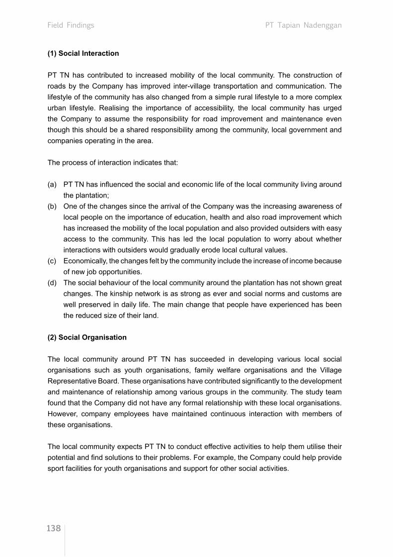
Field Findings
138
PT Tapian Nadenggan
(1) Social Interaction
PT TN has contributed to increased mobility of the local community. The construction of roads by the Company has improved inter-village transportation and communication. The lifestyle of the community has also changed from a simple rural lifestyle to a more complex urban lifestyle. Realising the importance of accessibility, the local community has urged the Company to assume the responsibility for road improvement and maintenance even though this should be a shared responsibility among the community, local government and companies operating in the area.
The process of interaction indicates that:
(a) PT TN has influenced the social and economic life of the local community living around the plantation;
(b) One of the changes since the arrival of the Company was the increasing awareness of local people on the importance of education, health and also road improvement which has increased the mobility of the local population and also provided outsiders with easy access to the community. This has led the local population to worry about whether interactions with outsiders would gradually erode local cultural values.
(c) Economically, the changes felt by the community include the increase of income because of new job opportunities.
(d) The social behaviour of the local community around the plantation has not shown great changes. The kinship network is as strong as ever and social norms and customs are well preserved in daily life. The main change that people have experienced has been the reduced size of their land.
(2) Social Organisation
The local community around PT TN has succeeded in developing various local social organisations such as youth organisations, family welfare organisations and the Village Representative Board. These organisations have contributed significantly to the development and maintenance of relationship among various groups in the community. The study team found that the Company did not have any formal relationship with these local organisations. However, company employees have maintained continuous interaction with members of these organisations.
The local community expects PT TN to conduct effective activities to help them utilise their potential and find solutions to their problems. For example, the Company could help provide sport facilities for youth organisations and support for other social activities.

Field Findings
139
PT Tapian Nadenggan
(3) Social Institution
Local institutions that were responsible for promoting community aspirations in the process of compensation and release of community rights consisted of the Village Head, chairperson of Neighbourhood Group, customary leaders and religious leaders. The Village Head of Pembuang Hulu I successfully performed his role as mediator for every problem concerning the plantation. Customary leaders and religious leaders were honoured by the community and the Company and their decisions respected. The study team could not find any negative impact caused by the role and performance of formal and informal leaders in representing the community in negotiations. The community around the plantation continues to observe and honour their customs and traditions, as does the migrant population who makes a serious effort to blend with the local community.
The relationship between the community and the plantation is quite good, although there was initially a conflict between the part of the community that supported the plantation and those who rejected it. The conflict focused on the smaller size of community land after most of it was relinquished to the plantation even as the population continued to grow. Those who eagerly embraced the plantation scheme agreed that people would have less opportunity to plant upland rice. However, they noted that the plantation had opened road access and created new employment and therefore the plantation and local community should maintain good relations for mutual benefit.
Expansion of PT TN has also reduced the forest area and the resources available for people to collect (e.g. building material, firewood, medicine, resin and rattan) and to hunt (e.g. wild boar, deer, mouse deer and birds).
The current sources of income of the local community in Pembuang Hulu I, Tanjung Hara, Derangga, and other villages around the plantation consist of agriculture, animal husbandry, fishing, collecting forest resources, and others. One of the most important sources of agricultural income is rubber; about 60% of the population is involved in rubber cultivation, particularly those living in traditional villages along Seruyan River. In contrast, most of the population living near the road works for PT TN.
The community breeds cows, chickens, and other livestock. They fish only for their own consumption. Collecting forest products has become less important as forest land has shrunk and the government prohibits people to cut down trees in the forest.
Matters regarding relationships between the community and the Company or between members of the community are successfully handled by the Village Head, and matters concerning customs and traditions are handled by the Damang (Adat Chief) who resides in the sub-district capital. According to the local community, all problems are resolved through negotiation, except for unsettled land disputes that had to be referred to the police or courts.

Field Findings
140
PT Tapian Nadenggan
The presence of PT TN has not affected family life negatively, as people are focused on fulfilling the needs of their families. The research found that each family could now afford a television, cellular phone and up-to-date clothes. It also found that children living around the plantation enjoyed grade school education and had access to healthcare.
The Company builds places of worship for its employees depending on their respective religions. The different religious communities co-exist in harmony. Customs and traditions are used as life guidance and social control, while religious teaching modifies its implementation.
The community around the plantation has enjoyed primary education for a long time. When PT TN arrived in the area, education received serious attention from the management. The Company provides transportation to take workers’ children to and from school. The Company also provides standard textbooks and pays honorariums for non-permanent teachers in the surrounding villages. Students of Pembuang Hulu vocational school often take apprenticeship in the Company. This cooperation has a positive impact on the community, especially as education needs to be developed continually.
(4) Self-Perception and Social Behaviours
As is generally true with other oil palm plantations, the local community’s perception on PT TN’s presence was mixed. Those in favour of it thought the Company had a positive impact by creating jobs and improving income levels. The people who opposed the plantation said the source of their income was destroyed by the plantation, as there was less land to cultivate upland rice and collect wood.
People’s perceptions toward the environment have changed. Originally, the community believed that the environment and natural resources belonged to a supernatural owner and were therefore sacred. Today they understand that the environment and natural resources can be developed to satisfy people’s needs and growth, provided they are managed responsibly and sustainably.
3.5.2.7.2. Economic Impact
The Company has gradually provided employment for people living around the plantation. Initially, the local community was not interested to work in the Company because many alternatives were still available at the time, such as planting upland rice, tapping rubber trees, gold mining, cutting timber, etc.
In the last few years, the local people have turned their attention to jobs in the plantation because the government prohibited cutting timber and mining for gold without a permit due to the adverse environmental impact. Rice farming could produce only enough for subsistence, and the price of rubber fluctuated wildly.

Field Findings
141
PT Tapian Nadenggan
Now, about 50%-60% of people living in villages around the plantation work for PT TN, particularly those who live near the main road and the access road to the plantation. The village leaders said that so far none of the high-ranking positions in the plantation were held by local people, partly because most of the locals were new recruits, and partly because their level of education and industry knowledge was still lacking compared to candidates coming from outside the community. People who work for the Company almost invariably strive to reach permanent worker status because they are paid a daily or monthly salary and entitled to various benefits.
Jobs in the plantation became available in line with the stages of development of the Company. At first, jobs involved planting and the upkeep of immature plants, but after the plantation started producing, more jobs became available. These included harvesting and transporting FFB, and working in the processing plant to convert FFB into crude palm oil (CPO) and palm kernel oil (PKO).
Besides PT TN, there are several other oil palm plantations in Hanau and Danau Saluluk Sub-districts, owned by individuals, groups, or companies. This gives the community job alternatives and freedom to choose where to work. They could decide based on considerations of wages, work status, distance, and amenities provided by the Company such as transportation for workers.
The villages of Tanjung Hara and Tanjung Paring are geographically close to PT TN, but villagers from there could not work at PT TN plantation. Their access to the plantation was cut off by a large swamp. As a result, most people from the two villages worked at another oil palm plantation called PT Musi Rawas. To address this problem, PT TN and the local community worked together to build a road across the swamp.
Besides providing direct employment for the surrounding community, PT TN also created conditions for the local and migrant population to start small businesses in the area. These opportunities arose because there were many aspects of oil palm production that the Company could not do alone. A number of business opportunities created by the existence of PT TN consisted of contracts for transportation of FFB, vehicle workshops, electronics repair shops, food markets, building material stores, clothing shops and food stalls.
The need for such services increased in tandem with the development of the oil palm plantation. Meanwhile, the growing number of workers residing around the plantation stimulated an increase of peddlers selling vegetables, cooked food and cold drinks. Not all members of the community could take advantage of the opportunities that emerged after PT TN arrived. Many people could not adapt quickly to the development and changes happening around them.

Field Findings
142
PT Tapian Nadenggan
There were a number of groups in the community who are easily provoked into opposing the operation of the plantation or raising unreasonable claims. This is understandable, as people who are unable to compete in finding employment and business opportunities tend to become confrontational.
The level of community welfare is much improved compared to a few years ago. The cause of this improvement is the availability of employment and business opportunities that are more reliable than jobs that depend on unpredictable natural resources. Improvement of community welfare can be detected in the condition of housing and the ownership of motorcycles, electronics and communications equipment. Houses in the local community are now made of wood and concrete. Even at Hanau Sub-district there is a hotel for visitors. But houses at Tanjung Hara Village, Tanjung Paring Village and Tanjung Rangas Village are very simple, because these two villages have no access to the main road. Almost every family in the villages around the plantation owns a motorcycle; some own four-wheeled vehicles that they use for transporting materials and goods.
Figure 3.52. House and road construction in the villages
Figure 3.53. Information and communications infrastructure
Economic and population growth due to the presence of PT TN have encouraged the government to accelerate the development of local telecommunication facilities. These facilities make it possible for more people to own radio, television and mobile phone. Therefore, PT TN has indirectly contributed to improved communication between communities and between villages.

Field Findings
143
PT Tapian Nadenggan
The lack of readiness of the local community to compete and take advantage of the rapid changes is partly due to lack of attention from local government. The local government should treat the creation of community economic infrastructure as a priority, so that the local community can respond appropriately to rapid changes in the local economic structure.
An evidence of the lack of economic infrastructure around the plantation is apparent after their pay day. After receiving their pay, the workers and employees travel by road to a market some 30 km away at Natei Kerbau.
This happens because there is no central market near PT TN. The existing market is accessed by river, but river transportation is no longer commonly used.
Figure 3.54. Condition of the market near PT TN
Figure 3.55. Road infrastructure and port near PT TN
The roads around PT TN consist of paved roads at the villages of Pembuang Hulu I, Pembuang Hulu II and Derangga, and dirt roads at Tanjung Hara and Tanjung Paring villages. Road conditions in the latter two villages turn bad during the rainy season. Fortunately, the river can still be used as a means of transportation during the rainy season.

Field Findings
144
PT Tapian Nadenggan
3.5.2.8. Corporate Social Responsibility (CSR)
Implementation of CSR by PT TN from 2008 to 2010 concentrated mainly on education. Although activities during this period were an improvement compared to previously, the community saw it as very limited. In 2008, the Company paid the honorarium of two teachers assigned to Hanau/Pembuang Hulu and Tanjung Paring/Sandul. The Company again paid the honorarium for teachers at Hanau and Miftahussalam Education Foundation in 2009. In addition, the Company renovated a football field to support sports development in schools, and provided a donation for students to participate in the School Olympiad in order to improve the quality of education.
The community reported that the Company paid minimal attention to healthcare. The Company provided medical services only to its workers and employees, although the poor and the old in the community were badly in need of medical help. In 2011, the Company implemented a programme providing eye checks and free eyeglasses for teachers and students from grade school to senior high school. This was the first health programme implemented in collaboration with the Tzu Chi Buddhist Foundation.
The community thought that PT TN’s support for the local market is still limited, as the Company buys most of its supplies either from Sampit or Pangkalan Bun. The community expects the Company to spend its earnings locally, so that the local economy can develop vigorously.
Figure 3.56. Transportation of FFB by local contractor
As a way to demonstrate its participation in the local community, PT TN staged a bazaar to sell cooking oil at a lower price. The bazaar was applauded by the community, especially poor families.
The type of cooperation between the community and the Company that has created high value is the transportation of FFB by local contractors. However, this opportunity is out of the reach of most people, as it only applies to those who own trucks.

Field Findings
145
PT Tapian Nadenggan
Company participation in the development of physical infrastructure includes the improvement and maintenance of village roads, provision of heavy machinery, construction of irrigation drainage in the community’s rice fields, and construction of the access roads connecting PT TN to Tanjung Hara and Tanjung Paring villages.
The Company regularly contributes to celebrations of Indonesia’s Independence every August 17 as well as religious holidays. However, the community expects bigger donations because earlier donations were deemed insufficient. For Pilgrimage Day (Idul Adha) the Company distributed meat to Moslems. For the purpose of maintaining harmonious relations with the Moslem community, the Company donated 100 sacks of cement to build a small house of worship (langgar), and made a donation for Qur’an reading competition, Musabaqah Tilwalatil Quran (MTQ), at Hanau Sub-district. These efforts promote harmonious relations between the Company and the local community.
Participation of PT TN in emergency situations is still lacking, although the Company occasionally transports sick people to the clinic. However, the local communities have been reluctant to ask for help.
Details of PT TN’s CSR activities since 2010 are shown in Table 3.7.
Figure 3.57. Irrigation drainage and access road constructed by PT TN

Field Findings
146
PT Tapian Nadenggan
Table 3.7. PT TN’s CSR activities in 2010
No Activity Location PeriodEducation
1 Donation to kindergarten school and Al-Qur’an Educational Centre Tanjung Paring 2010
2 Providing Honorarium fund for teachers in Miftahussalam Foundation Pembuang Hulu 2010
3 Honorarium for teachers Sandul and Pembuang Hulu 2010
4 INSTIPER Yogyakarta students apprenticeship
Tanjung Paring, Tanjung Mas Village and Hanau Sub-district
2010
1 Donation to Gotong Royong Day Danau Saluluk Sub-district 2010
2 Donation to School Olympiad in Hanau Sub-district Pembuang Hulu 2010
3 Donation to Regional Student Sports Week in Hanau Sub-district Pembuang Hulu 2010
Infrastructure
1 Upgrading of school yard Sandul 2010
2 Road upgrading Pembuang Hulu and Derangga 2010
3 Construction of access road to PT TN Tanjung Paring and Tanjung Hara 2010
4 Al-Hidayah Mosque renovation Kalang 2010
Social/Cultural
1 Qur’an reader contest (MTQ) in Hanau Sub-district Pembuang Hulu 2010
2 The Republic of Indonesia Anniversary Celebration Hanau Sub-district 2010
3 Sponsorship of Batu Ampar Sub-District anniversary celebration Sandul 2010
4 Flagpole purchase Sandul 2010
1 Cooking oil bazaar Hanau and Danau Saluluk Sub-districts 2010
Source: PT TN Management, 2010

Field Findings
147
PT Tapian Nadenggan
3.5.3. Conclusions
Based on the above analysis, we can draw the following conclusions and evaluations:
(1) The research did not find any invitation letter or attendance list for the compensation negotiations between PT TN and the community that owned and controlled the land. However, all the subjects or sources of information of this research confirmed that such negotiation was in fact conducted between the plantation and land owners to determine the standard rate of compensation for land and cultivated plants.
(2) Sufficiently good drawings/sketches exist indicating the location and boundaries of the land acquired by PT TN. These maps were made by PT TN during the acquisition process and are only available for the Company’s internal use.
(3) PT TN executed a planting programme from 2005 to 2007. The planting was done on degraded land, secondary forest (previously forest concession), covered with Imperata cylindrica and bushes.
(4) The area for basic occupations such as rice cultivation, hunting, fishing and collecting of wood for building material, has become smaller. However there is enough land left for such activities. The area has never experienced a food crisis, as the community has new jobs working at the plantation and their access to food is increasing. Most of the people who lived along the banks of Seruyan River relied on rubber as their traditional source of income, and the number of people working for the oil palm plantation fluctuated along with changes in the price of natural rubber. When the price of rubber was high, they returned to tapping rubber, and when the price was down they went back to work at the PT TN plantation. Thus, the presence of the plantation has not deprived local people of freedom of choice; they may come and go as they choose.
(5) The research did not find any site that was regarded as sacred inside PT TN’s concession. Some kaleka exists in surrounding villages but these sites are well maintained by people from nearby public settlement along the Seruyan River.
(6) PT TN engaged an external consultant in 1999 to conduct SEIA. The local community was involved in the SEIA. In 2006 additional assessment was conducted due to the expansion of the oil palm plantation and processing mill in PT TN and the result was then added to the 1999 SEIA report as an addendum.

Field Findings
148
PT Tapian Nadenggan
(7) Socialisation of PT TN’s plan to start an oil palm plantation was conducted in a simple way. The Company approached the district head, head of District Plantation Office, sub-district head and village head in person. The socialisation was not, however, conducted in the villages around the plantation. Unfortunately, documentation could not be found because it took place 15 years ago. It was also difficult to trace the officials who were in charge at the time. Furthermore, there was no obligation at the time for oil palm plantations to conduct socialisation let alone to keep documentation of it.
(8) A record of each compensation payment is evident from the document of land compensation (signed by the land owner and representative of the Company and co-signed by the village head and sub-district head), receipt, copies of the recipient’s identity card, photograph of the recipient, proof of ownership, and a letter of authorisation if the owner could not attend. The community had the freedom to disagree with the compensation rate, as PT TN did not exert any undue pressure.
(9) Identification and evaluation of legal and traditional rights over the land were made on the basis of confirmation by witnesses consisting of community leaders and local government officials. The research found that negotiations over compensation took place between land owners and the Company.
(10) Identification of the parties who were entitled to receive compensation began when there was a claim (written or oral) by the local community to the Company management. This was followed by: measurement and mapping conducted by the Company, local community and village officials: contacting community leaders to trace witnesses of land ownership; and finally, the transfer of land ownership documents.
(11) Implementation of CSR by PT TN has been limited to providing donations to various applicants, although the presence of the Company has created added value for the community in various fields of occupation.

Field Findings
149
PT Tapian Nadenggan
3.5.4. Recommendations
(1) PT TN should keep on exerting pressure on decision makers at district and provincial level to finalise the Provincial Spatial Planning so that the plasma scheme can be implemented for the community.
(2) The CSR programme should be expanded beyond giving donations. There should be a stronger focus on the development of the local economy based on mutual cooperation between the community and the Company.
(3) In order to minimise double claims of land ownership, the Company should put up a public notice when the agreement is reached with the land owner to inform the community on the land acquisition before executing the compensation payment.

Field Findings
150
PT Satya Kisma Usaha
3.6. PT Satya Kisma Usaha (SKU)
3.6.1. Company Profile
PT Satya Kisma Usaha (SKU) was established under the Articles of Incorporation Number 30 dated 7 August 1978. On 14 April 2008, the Company changed its Articles of Incorporation and obtained approval for change of the Company statute into the Articles of Association No. AHU-29383.AH.02.02 of 2008 on 30 May 2008. On 10 September 2009, the Company made the latest change with the issuance of the Articles of Association No. AHU-AH.01.10-15390.
The Plantation Business License Number: 525/1233/UT/1995 dated 9 November 1995 was issued by the Plantation Office of Central Kalimantan Province for PT SKU. The Land Permit Number: 39.480.42/BPN/I-1997 dated 19 January 1996 was issued by the National Land Agency of Kotawaringin Barat District for the Company operations in Ragda and Toman Villages, Arut Selatan Sub-district. The land permit was renewed on 6 May 1997 with Land Permit Number: 227.780.42/BPN/V/1997 issued by the the National Land Agency of Kotawaringin Barat District which is valid until 2010. The extension of the Company’s land use title is currently being processed.
Based on the Recommendation Letter from the Governor of Central Kalimantan Province Number: 525.26/754/1996 dated 4 November 2006 regarding the Release of Forest for Cultivation of Oil Palm to PT SKU, the total plantation area is 7,730 ha.
The process of obtaining the Land Use Title was done in two stages. The first stage involved measuring the area perimeter as set forth in Certificate Number DI.302.500/2000 dated 28 September 2000 covering an area of 6,950 ha. The second stage was the issuance of Land Inspection Document under “B” Category Number: 102/PPTB/X/2006 dated 6 October 2006 which extended the location of PT SKU from Medang Sari Village to include Runtu Village.
PT SKU is divided into two locations that share boundaries with the concessions of other companies as follows:The first location shares its boundaries with:On the north side : PT Surya Sawit Sejati plantation area;On the east side : Medang Sari Village, Arut Selatan Sub-district;On the south side : PT Medco plasma estate;On the west side : Concession area of PT Surya Sawit Sejati and Arut Selatan River.Meanwhile, the second location shares its boundaries with:On the north side : PT Surya Sawit Sejati and Runtu Village, Arut Selatan Sub-districtOn the east side : PT Astra Group area;On the south side : PT Medco plasma estate;On the west side : PT Surya Sawit Sejati and Arut Selatan River.

Field Findings
151
PT Satya Kisma Usaha
As stated in the Company’s documents, the Company has been paying compensation for community lands during the period of 1998 to 2009. The calculation of land compensation was based on land area and productive plants found in the area. The compensation rate was adjusted over time and is based on agreement with the land owners.
The total land area used by PT SKU to develop its oil palm plantation is 6,950 ha, but the plantings only cover 2,563 ha (36.88%). The land preparation was divided into five stages: (1) 443 ha in 1999; (2) 492 ha in 2000; (3) 613 ha in 2006; (4) 500 ha in 2007; and (5) 358 ha in 2008. Of the cleared area, 77.12% of the land is owned by the local communities.
Figure 3.58. Map of PT SKU Location
The existence of PT SKU’s oil palm plantation in Kotawaringin Barat District has significantly contributed to the creation of employment and business opportunities for the surrounding community. According to company data, in 2010, PT SKU recruited 555 individuals which included 90 permanent workers (administration and services) and 465 field workers.

Field Findings
152
PT Satya Kisma Usaha
3.6.2. Field Findings
These field findings are derived from Focus Group Discussion (FGD), in-depth interview, structured interview and field observation which were conducted for the community in PT SKU. Three sessions of FGD were conducted in the existing three villages with a total of 40 participants. In-depth Interviews were done with 13 informants consisting of informal leaders, custom leaders and farmers in PT SKU concession. Structured interviews were done for 10 persons representing district officials, village officials, sub-village officials and Company’s management.
3.6.2.1. RSPO Criterion 2.3
Based on data from the Company; discussion with the community; in-depth interviews with informal leaders, merchants, business owners, the manager and assistant manager of the Company; and structured interviews with village and sub-district officials at Runtu, Makarti Jaya, Medang Sari Villages, Arut Selatan Sub-district and Pangkalan Lada Sub-district, the results of the study are as follows:
(1) This study reveals that the use of land for the oil palm plantation does not reduce the legal or traditional rights of the land owners. The results of FGDs, in-depth interviews and structured interviews show that the land owners relinquished their land rights through a compensation system.
(2) Some members of the community who did not wish to release their land were allowed to remain in enclaves inside the Company plantation area which is designated as an area for miscellaneous purposes in PT SKU. This area covers 111 ha, including approximately 2 ha of enclaved area based on the field survey.
Figure 3.59. Enclaved land, approximately 2 ha based on the field survey
(3) In 1999, the land in Medang Sari Village was planted by the Company, but the subsequent community reclaimed it.

Field Findings
153
PT Satya Kisma Usaha
(4) Upon confirmation with staff of Medang Sari Village Office, it turns out that the Company had only socialised with the village officials to seek permission for land preparation but had not directly met the villagers.
(5) Compensation for land owned by the community only took place after the community claimed their land. Subsequently, the Company verified the ownership status of the land with the land owners, village official and district official. After verification, the compensation price was negotiated according to the claim.
(6) The community’s traditional rights could not be proved formally and legally because there were no written documents, maps or sketches of the location that clearly showed the location and shape of the land. Proof of traditional ownership is indicated with physical evidence of the land and plants growing in it as well as the testimony of community members who have reliable knowledge of the traditional ownership. PT SKU has made a map of traditional land ownership to be compensated. However, the unit head of PT SKU did not have the authority to release the map.
(7) Copies of documents for the final settlement are well documented. However, the initial process leading up to the final settlement was not documented. The land owners do not have copies of those documents.
(8) As part of the land compensation process, the Company kept documentation of the release of traditional rights, but land owners do not have a copy. The local police also kept some of the data at the Community Police division, but their documentation was limited to photographic documentation, such as photographs on land measurement using a Global Positioning System (GPS), etc. Documentation of the compensation process involving the land owner and the Company is already completed with the location map. SOP Number: SOP/NP/SMART/VII/D of 2010 Revision 02 on point 7 states that the compensation document should be made in triplicate and the third copy should be given to the land owners. The SOP was only introduced in 2010 long after the compensation process was done. Therefore, it can be argued that there has been no violation of the 2010 SOP.
(9) Findings on the negotiation and agreement process between the community and the Company which are archived at PT SKU conclude that: (1) The results of negotiation/payment of land compensation between the Company and the land owner have been well documented; (2) Each payment is documented with a final agreement document affixed with stamp, acknowledged by the Village Head and Sub-district Head, witnessed by the head of local police, and documented with a photograph; (3) There is a receipt for each payment with seal and thumbprint of the person receiving the compensation (the holder of traditional rights); (4) There is a photocopy of the identity card of the person who received the compensation; (5) There is a photo of the land owner; and (6) There is certificate or letter of land ownership.

Field Findings
154
PT Satya Kisma Usaha
3.6.2.2. RSPO Criterion 7.3
Field findings from in-depth interviews, structured interviews and FGDs based on indicators of RSPO Criterion 7.3 are as follows:
(1) PT SKU conducted High Conservation Value (HCV) assessment by an internal staff who is an RSPO-registered assessor in August 2010. The HCV assessment document has been peer-reviewed by the Faculty of Forestry of Bogor Agricultural Institute and is currently being finalised. Although the document is not finalised, the Company has implemented the recommendations from the HCV Management and Monitoring Plan.
(2) Land preparation was done in stages. The area in Medang Sari Village was cleared in 1999 while the area in Runtu Village was cleared in 2000. Over the period 2006–2008, there were planting activities around Runtu Village where the compensation had been paid previously. There was no new planting during the period November 2005 to November 2007. PT SKU’s last planting was in 2008.
(3) Findings from new land preparation include the following:
(a) Except for Medang Sari Village, there was advance approval from the local community to transfer land ownership.
(b) The method that had been applied to ensure the Free Prior Informed Consent (FPIC) principle consisted of verification of land ownership status followed by compensation and establishment of enclaves for those who did not want the compensation.
(c) Documentation ensuring that the process of land release had been carried out in a legally responsible manner include:o Receipt of payment affixed with stamp and signature of the person who
received the compensation/owner of the traditional right.o Final Agreement signed by the owner of traditional rights and a representative
of the Company, Village Head and Sub-district Head with affixed revenue stamp.
o Copy of identity card of the person who received the compensation.o Photograph of the compensation recipient.o Certificate of land ownership.

Field Findings
155
PT Satya Kisma Usaha
3.6.2.3. High Conservation Value 5 (HCV5)
HCV5 refers to a forest area that is highly necessary as a source for the local community to meet its basic needs. The closest villages that share boundaries with PT SKU are Medang Sari and Runtu Villages. The findings in relation to HCV5 are as follows:
(1) Part of the forest area under PT SKU’s oil palm plantation is secondary forest. Since the distance between the forest and the settlements of Runtu and Medang Sari Village is quite far and the cultivated field in the forest area is small, the forest area is not considered important for the fulfilment of basic needs of local people. Instead, the community of Medang Sari and Runtu Villages rely on the surrounding areas that share a boundary with PT SKU to fulfil their basic needs. Thus, there is no indication of problems relating to HCV5 in the area.
(2) In the early days of PT SKU, the area surrounding the village was still secondary forest. At that time, the area was the source of income for the local community, as people planted pepper, gathered firewood, hunted and fished in it. After oil palm companies entered the area, the local community’s source of income changed. They began to work for the Company as field officers or security guards, and opened businesses to provide food and sundries, Fresh Fruit Bunch (FFB) transportation and vehicle repair services.
Figure 3.60. FGDs conducted in Runtu Village, Makarti Jaya Village and Medang Sari Village

Field Findings
156
PT Satya Kisma Usaha
(3) The forest area in the PT SKU concession is partly secondary forest and partly enclaved fields owned by the local community. The area does not function as a source of basic needs fulfilment for the local community, because basic needs can still be supplied by the surrounding area of Medang Sari and Runtu Villages.
3.6.2.4. High Conservation Value 6 (HCV6)
HCV6 refers to a forest area needed by the local community to preserve their cultural identity as well as their religious practices. This kind of forest is considered sacred and protected by traditional law. The forest is regarded as a resting place of their ancestors and also functions as a sanctuary for flora and fauna related to their religion/beliefs. Findings relating to HCV6 are explained below:
(1) Various ethnic groups live around PT SKU, namely Mendawai, Banjar, Javanese and Batak. Of three villages that share boundaries with PT SKU, only Runtu Village remains inhabited by indigenous people that use the local dialect of the Malay-Mendawai language. Most local people come from the Mendawai ethnic group and are Moslem. In general, sacred places cannot be found throughout the village.
Figure 3.61. Map of traditional land prepared by Medang Sari Village officials
(2) Makarti Jaya and Medang Sari Village are transmigration settlements inhabited by transmigrants from outside Kalimantan. However Medang Sari Village has traditional land as shown by the (unscaled) map created by village officials. The study indicates that there is no sacred place in the village or sacred forest around the village. Therefore, there is no indication of HCV6 in the area.
3.6.2.5. RSPO Criterion 7.5
Based on data obtained from the Company, discussion with the community; in-depth interviews with informal leaders, traders, service providers and the Company manager, and structured interviews with village officials at Runtu, Makarti Jaya and Medang Sari Village, it is reported that:

Field Findings
157
PT Satya Kisma Usaha
(1) The opening and extension of the plantation by PT SKU in Runtu and Makarti Jaya Village were preceded by socialisation to the community and village officials, and well documented by PT SKU. However, for Medang Sari Village there was no prior community outreach. The Company merely visited the Head of Medang Sari Village and set up a meeting in the village hall where the Company explained the plan to open an oil palm plantation and requested the permission.
(2) New planting during the period 2006–2008 has fulfilled legal requirements including the management of social and environmental impacts. PT SKU engaged CV. Mitra Karya Prima to conduct a Social and Environmental Impact Assessment (SEIA) in 2003. In the main SEIA report, negative and positive impacts on social and environment were revealed. Environmental impact is seen from the positive and negative impact of the physical and chemical components, socio-economic and cultural components and a public health component. Based on the analysis of community and environment, the existence of oil palm plantation was assessed to have an important impact on the community that borders PT SKU.
(3) The environmental analysis section of the SEIA report of PT SKU found micro climate changes, namely decreasing air quality and increasing sound pollution from trucks passing through the area. However, the community is not directly affected by it. Positive impact comes from land cultivation as the fertiliser used increases levels of nitrogen, phosphorus and potassium that are beneficial to the land.
(4) PT SKU’s land preparation activity covered a vast area and was close to several villages. This resulted in lesser land available for the local community for hunting and gathering non-timber forest products. Nevertheless, some of the people had new alternative sources of income by working for the Company or opening businesses in the service sector and selling goods needed by the Company or local community. On the whole, the community’s income improved.
3.6.2.6. RSPO Criterion 7.6
Based on discussion with the community, in-depth interviews with informal leaders, traders, transportation services providers in the village and managers of the companies as well as structured interviews with village and sub-village officials and other stakeholders, the following conclusions can be drawn:(1) Records of identification and valuation of legal and traditional rights are available. This
identification and valuation involved related government institutions at the village and sub-district level. The document is available at PT SKU’s offce.
(2) Upon the opening of the oil palm plantation at Medang Sari Village, PT SKU initiated procedures to identify those entitled to compensation. This was done by disseminating information about the Company’s plan to the community living in the area and sharing

Field Findings
158
PT Satya Kisma Usaha
boundaries with the Company. The meeting was held at the village office and attended by the Company representative and village officials. The Company explained that it had a permit to develop an oil palm plantation in that area and explained that the Company would pay compensation for any land traditionally owned by the community and located inside the plantation.
(3) The compensation process in Runtu and Makarti Jaya Villages was carried out properly based on a mutual agreement between the community, the Company and the local government. The findings on this process include:
(a) According to village officials of Makarti Jaya, PT SKU did not start land preparation before the status of the land was clear.
(b) Based on FGD in Makarti Jaya, the compensation from the Company was accepted because the amount was mutually agreed between the Company, the community and the village and sub-district officials.
(c) The compensation process for land owned by the community inside PT SKU’s area was facilitated by the local government. According to the community, this was the best compensation process they had ever experienced.
(4) The problem of land compensation in Medang Sari Village involved three families who did not want to accept compensation. According to village officials, these families did not want to accept the money from the Company but preferred to exchange their land with oil palm planted land instead. When asked for confirmation, PT SKU has responded that the Company cannot meet their request since the Company already has an agreement with the local government on the issue and compensation was readily available at that time.
3.6.2.7. Socio-economic Impact
The socio-economic impact of the land acquisition and the importance of PT SKU to the local community of Medang Sari, Makarti Jaya and Runtu Village are as follows:
3.6.2.7.1. Social Impact
(1) Interaction process
Social interaction between the Medang Sari villagers and PT SKU is not very harmonious. There is some evidence that land conflict and other complaints have not been resolved, such as:

Field Findings
159
PT Satya Kisma Usaha
(a) Three families did not want to release their land rights to the Company; (b) Cooking oil of bazaar/distribution held by PT SKU in December 2010 in Runtu, Makarti
Jaya, Melawen and Medang Sari which only focused on poor people (some of whom worked for the Company as daily workers) created social envy among other community members;
(c) Most members of the community complained that the village road (connecting Sampit and Pangkalan Bun) has been ruined by company trucks that cross the road to transport FFB;
(d) village officials revealed that the Company’s corporate social responsibility (CSR) programme is very limited.
The Company’s existence has also generated some positive impact on social interactions, such as:(a) The people of Makarti Jaya and Runtu Village felt that interaction is intensifying due to
the increasing size and mobility of the surrounding community and company workforce. This is due to the newly opened access to the surrounding area and cities.
(b) The operation of the oil palm estate started with land preparation, planting and maintenance of immature plants, that demanded many of workers. The need for workers, however, could not be met by local communities. At that time, there were not many villagers interested in working with the Company bacause there were many job alternatives which were more suited to the habits of the community which was unused to working with a specific target and tight regulation. At the time, the local community preferred to continue traditional activities rather than work for the Company. As it was difficult to recruit locals, the Company hired migrant workers.
The existence of migrant workers from outside the community to work at the plantation or to open businesses in this more developed village has not created any conflict with the local community, and the social interaction between locals and migrants is good.
(2) Organisation and Social Structure
As explained previously, the opening of the oil palm plantation has provided better access to the community living in the interior region. This has led to social, economic and cultural changes as well as a new orientation for the community.
Runtu Village used to be a small sub-village near the Arut River bank and with a very small population. Because of development of the area and the operation of the oil palm company, the population has increased as a result of migrants.
Although many factors influence the change in organisation and social structure, it is believed that the existence of the oil palm company is the dominant factor bringing about that change. In addition, it should be noted that development of the area surrounding PT SKU is not

Field Findings
160
PT Satya Kisma Usaha
only dependent on the existence of PT SKU, but also on such factors as road access at 12 km of the Trans-Kalimantan Highway that connects the capital cities of Kotawaringin Timur, Kotawaringin Barat and Lamandau Districts.
Many job and business opportunities generated by the presence of the oil palm company have created a particular impact on social classification in the surrounding community, especially as a result of increased welfare. The increased welfare can be seen from several indicators such as the condition of houses, ownership of vehicles and fulfilment of secondary and tertiary needs. Most people already have proper and permanent houses (concrete buildings) or semi-permanent houses along with the ownership of vehicles and entertainment equipment. All in all, it can be concluded that in general they are quite prosperous. Unfortunately, the electricity grid has been provided by the State Electricity Company in Makarti Jaya and Runtu Villages. Many households own their own electric generators to power their homes.
(3) Social Institutions
Local institutions that play a major role in supporting the community in land compensation as well as land release are the Village Heads, Heads of Neighbourhood Group, informal leaders, traditional leaders and religious leaders. Their service has a major influence on the community life. For instance, Village Heads of the villages that share boundaries with PT SKU play a major role as mediators and are trusted by the community to settle any dispute with the Company. Traditional and religious leaders are also respected by the community and the Company.
Relations between the community and PT SKU are good, although there was once a conflict between a community group that supported the Company and another group that rejected the Company. The latter believed that the Company’s land acquisition had caused the village to shrink and therefore become more crowded when the population increased. A smaller land area has limited the community’s ability to rely on agriculture. However, in general, due to better road access to the community and the employment created by the Company, relations between the Company and the local community have improved.
(4) Social Perception and Social Behaviour
The communities have various perceptions of the Company. Part of the community supports the existence of the Company in their area, while others are against it. The former feel that the Company generates positive impact because it provides employment opportunities and increases wealth by paying compensation. Those against the Company’s presence rely on natural resources for their livelihoods and feel that the expansion of the plantation has limited their means. However, there is no significant behavioural change in the people of Medang Sari, Makarti Jaya and Runtu Villages as shown by the close-knit relationship among members of the community and the preservation of norms in their daily lives.

Field Findings
161
PT Satya Kisma Usaha
People in the community are of the view that they can decide their future with hard work and determination while there is still time to make the effort. The community also realises that change is inevitable and can lead to improvements.
Furthermore, community attitudes toward the environment have evolved. Initially they believed that the natural environment must not be disturbed because it belonged to a sacred entity. Now they believe that the environment should be used extensively utilised in a responsible manner to fulfil their needs and also for the sake of their development. This perception has a positive impact when the community and the Company become partners in utilising the land without neglecting the development of the surrounding community.
3.6.2.7.2. Economic Impact
Sources of income for Medang Sari, Makarti Jaya and Runtu Villages are agriculture, farming and others. The main agricultural product is pepper and for farming is chicken. Other sources of income are employment provided by PT SKU. The economic impact of the plantation is discussed in more detail below.
(1) Job Opportunities
Employment is an important aspect not only for individual satisfaction, but also for the fulfilment of the community’s basic needs. Since PT SKU shares boundaries with Medang Sari, Makarti Jaya and Runtu Villages, most of PT SKU’s workers come from those villages. The workers are employed for road and drainage works, oil palm maintenance, harvesting and transportation of crops to PT Tapian Nadenggan. Based on FGDs at the villages bordering PT SKU, the occupation of villagers consists of 72.4% farmers, 7.9% traders, 5.3% government officers, 3.9% fishermen, and 2.6 % daily workers.
Figure 3.62. Types of work in an oil palm plantation

Field Findings
162
PT Satya Kisma Usaha
(2) Business Opportunities
The main types of job and business opportunities for the community around PT SKU are: company worker, farmer (seed provider), peddler around the Company area, daily labourer and mechanic. Rapid development of oil palm plantation sub-sectors in neighbouring villages has also forced the Company to provide infrastructure needed for plantation-related activities and have led the community to provide services, engage in trading and transportation businesses, as well as agriculture and plantation (oil palm, rubber and pepper).
Figure 3.63. Business opportunities for community around the oil palm plantation
(3) Community Welfare
In terms of community welfare, interviews and FGDs with the community and government officials reveal positive impacts of the oil palm company such as: more job opportunities (reducing the unemployment rate), increased income and more business opportunities such as repair shops, and rerail outlets.
3.6.2.8. Corporate Social Responsibility
CSR efforts by PT SKU have significant social impact on the villages that border its plantation. As seen in Table 3.8, such activities have taken place in the following sectors: education, health care, empowerment of the local economy, infrastructure development and financial support for religious and national celebrations.

Field Findings
163
PT Satya Kisma Usaha
Table 3.8. CSR activities of PT SKU at Arut Selatan and Pangkalan Lada Sub-district of Kotawaringin Barat District, March 2010–February 2011
No. Activity Location Period
Healthcare
1Eye checks and distribution of free glasses
Makarti Jaya Primary School I
Feb 2011Runtu Primary School I and II
Medang Sari Primary School
Arut Selatan Junior High School VIII
Infrastructure
1 Village road upgrading Kadipi Village, Arut Selatan Sub-district Mar 2010
2 Village road upgrading Sarap Sub-village, Arut Selatan Sub-district Apr 2010
3 Village road upgrading Kadipi Village, Arut Selatan Sub-district Oct 2010
4 Village road upgrading Sarap Sub-village, Arut Selatan Sub-district Oct 2010
5 Soccer field upgrading Runtu Village Dec 2010
Social/Cultural
1 Donation for Qur’an reading contest Arut Selatan Sub-district Jan 2010
2 Donation for Qur’an reading contest Pangkalan Lada Sub-district Mar 2010
3 Donation for village anniversary
Kadipi Village, Arut Selatan Sub-district Mar 2010
4
Donation for celebration of the 65th Anniversary of the Republic of Indonesia
Kanambul and Medang Sari Villages, Pangkalan Lada Sub-district Aug 2010
5 Donation for sub-district anniversary Pangkalan Lada Sub-district Dec 2010
Economy
1 Contractors for employees transportation
From Pangkalan Tiga, Makarti Jaya and Kadipi Village to MSAE
Jan-Dec 2010
2 Contractors for FFB transportation From MSAE field to PKS HNAM Jan-Dec
2010
3 Cooking oil bazaar Runtu, Makarti Jaya, Medang Sari, Kadipi and Sungai Melawen Villages Dec 2010
Source: PT SKU Management, 2010

Field Findings
164
PT Satya Kisma Usaha
Through interviews and FGDs, the community informed PT SKU of the condition of schools in the area it hopes that PT SKU would devote more resources to the provision of school equipment and books to encourage the learning and reading habits of pupils.
Figure 3.64. The Company’s contribution to infrastructure
There is one specific finding at Medang Sari Village in relation to PT SKU’s CSR programme, where transportation of the FFB via the main road at Medang Sari Village had ruined the road condition. During FGD at Medang Sari, the community asked the Company to pay more attention to the road maintenance and repair. The Company on the other hand explained that in the period 2008-2010, it has made frequent repairs to the road by filling in laterite and grading the roads.
3.6.3 . Conclusions
(1) Before 2000, PT SKU only sought the permission of the village officials for its land preparation activities. After 2000, the Company began socialisation and engaging the community through outreach and discussion. The Company took care of compensation issues after the land had been planted, i.e. after claims from the community were raised. The process of acquisition was properly executed according to the agreement with community. Documentation during the process of land relinquishment was carried out according to the Company’s policy. In general, the land acquisition for oil palm plantation in PT SKU has not diminished legal and traditional rights of local community and does not violate RSPO criterion 2.3.
(2) Land preparation in PT SKU was not done in primary forest. Villages in the area around PT SKU’s concession still have farm land as a source of meeting their subsistence needs (HCV5). PT SKU’s existence has not diminished the local community’s ability to subsist, as basic necessities are still available in the local market. Components of HCV6, i.e. sacred places, could not be found in all three villages since most of the community comes from outside Central Kalimantan Province.
(3) Most of the area in PT SKU was planted before the end of 2007. Approximately 358 ha

Field Findings
165
PT Satya Kisma Usaha
were planted in 2008. New planting in 2008 was preceded by SEIA in 2003. Socialisation and compensation negotiation were done together with community representatives, village heads and sub-district heads. Socialisation activity has been done but not completely documented by PT SKU. New planting in PT SKU is in accordance with RSPO criterion 7.5.
(4) In relation to RSPO Criterion 7.6., the acquisition and land compensation process have been conducted according to mutual agreement between the Company and community. Community members who refuse to release their land are allowed to stay in the plantation. There is complete documentation of the land compensation process, land transfer and compensation payment which was done formally, signed by both parties and witnessed by village and sub-district officials.
(5) The existence of PT SKU has brought socio-economic changes to the surrounding community. Social changes that happened after the establishment of PT SKU relate to increasing awareness of the importance of education and health care as well as infrastructure that has improved mobility. Some negative impact involves: concerns over the decreasing land availability, degradation of air quality, noise pollution, and scarcity of agricultural workers in the villages. Social behaviour in the surrounding community has not changed significantly, as proved by strong relationships among members of the community and norms and local culture that remain preserved. One of the main reasons for this could be the long history of interaction between local people and migrants.
3.6.4. Recommendations
Recommendations of the study are as follows:
(1) To reduce the potential of land conflict with the community, the Company should inform the community and village officials prior to land preparation, by holding a meeting and reaching an agreement. The socialisation should follow the SOP for Land Compensation which was completed in 2010. The processes of socialisation and land compensation have to be properly documented and made available whenever needed by relevant parties.
(2) To reduce the potential for land conflict and social envy, the Company should show good faith in implementing CSR programmes based on discussions with the local comunity especially for local economy empowerment as well as the improvement of education. To pursue this, the Company is advised to form a special division which will be responsible for community empowerment.

Field Findings
166
PT Mitrakarya Agroindo
3.7. PT Mitrakarya Agroindo (MKA)
3.7.1. Company Profile
PT Mitrakarya Agroindo (MKA) was established under Deed Number 6 dated 16 February 2004 issued by Notary Hardinawanti Surodjo, S.H. in Jakarta, and officially validated by Decree of the Minister of Justice Number C-03107.HT.01.01 dated 4 February 2005. In 2008, the Company changed its articles of incorporation to Deed Number 17 dated 5 June 2008 issued by Notary Hardinawanti Surodjo, S.H. in Jakarta. Then, in 2009 once again the Company changed its articles of incorporation to Deed Number 45 dated 18 March 2009 issued by Notary Hardinawanti Surodjo, S.H., and acceptance of notification of changes in the Company data Number AHU-AH.01.10-05253, dated 5 May 2009.
This company also obtained Land Permit No. 500/192/EK/2004 dated 12 June 2004 to develop 20,000 ha of oil palm plantation, and the Plantation Business License was based on the Decree of the Head of Seruyan District Number 525/077/EK/2005 dated 11 April 2005 regarding development of oil palm plantation. The land permit was also obtained through the Decree of the Head of Seruyan District Number 194 of 2005 dated 22 December 2005 and Number 55 of 2006 dated 15 February 2006 covering 23,137 ha in Seruyan Tengah and Hanau Sub-districts of Seruyan District. The Land Use Title for PT MKA is still awaiting the completion of Provincial Spatial Planning of Central Kalimantan.
The boundaries of PT MKA’s plantation area are as follows:1) To the west, the plantation is bounded by Seruyan River. The community here lives
along the river banks in the villages of Teluk Bayur, Gantung Pengayuh, Derawa, Sebabi, Durian Kait, Kalang, Sandul, Tanjung Rangas, Tanjung Paring and Tanjung Hara. All these villages are located in Hanau Sub-district of Seruyan District;
2) To the east, the plantation shares boundaries with PT Kridatama Lancar, PT Teguh Sempurna, PT Binasawit Abadi Pratama and transmigration settlements of C-1, C-2 and C-3;
3) To the north, the plantation is bounded by Ayawan River;4) To the south, the plantation is bounded by the Trans-Kalimantan road connecting Sampit
and Pangkalan Bun.
The plantation at PT MKA was opened from 2006 to 2010. The first planting of 2,577 ha took place in Sulin, Nahiyang and Katayang Estate in 2006, while the last planting covering 1,065 ha was at Sulin, Nahiyang, Katayang and Sungai Nusa Estates in 2010. The total area of land prepared was 13,733 ha.

Field Findings
167
PT Mitrakarya Agroindo
Figure 3.65. PT MKA’s location map
(For the purpose of efficiency in management and supervision, PT MKA divided the area into four estates: Sulin Estate (SLNE), Nahiyang Estate (NHYE), Katayang Estate (KTYE) and Sungai Nusa Estate (SNSE); where each estate is run by a manager. In Its development, PT MKA paid compensation to the owners of 14,880 ha of community land during the period of 2006–2010.
As of 2010, PT MKA has 6,265 ha of immature plantation and 7,218 ha of mature plantation. From the mature plantation, the Company produces 79,366 tonnes of fruits with average productivity of 10.99 tonnes/ha per year. Besides managing its own plantation, the Company has also established a partnership with Sawit Karya Abadi Cooperative established by Cooperative Article No. 08 dated 15 October 2008 with 909 households as its members.
The existence of PT MKA in Seruyan District, Central Kalimantan Province has significantly contributed to the creation of job and business opportunities for the surrounding community. Based on data from the Company management, in 2010 PT MKA had 3,193 workers, consisting of 471 administrative staff and 2,722 field workers.

Field Findings
168
PT Mitrakarya Agroindo
Figure 3.66. The administrative office in PT MKA
3.7.2. Field Findings
These field findings are derived from Focus Group Discussions (FGD), in-depth interviews, structured interviews and field observation, which were conducted with the community in three villages within the concession area of PT MKA. Three sessions of FGD were conducted in these three villages with a total of 36 participants. in-depth interviews were done with 13 persons consisting of informal leaders, custom leaders and farmers in PT MKA’s concession. Structured interviews were done with 10 persons representing district officials, village officials, sub-village officials and the Company’s management.
3.7.2.1. RSPO Criterion 2.3
RSPO Criterion 2.3 states: “Use of the land for oil palm does not diminish the legal rights, or customary rights, of other users, without their free, prior and informed consent”. There are three main indicators in relation to RSPO Criterion 2.3: (1) Records of the negotiation process between traditional land owners and Companies (if any), supplemented with maps in appropriate scale; (2) Maps of an appropriate scale showing the extent of recognising customary rights; and (3) Copies of negotiated agreements detailing the process of consent.
Results of the study are as follows:
(1) The area of PT MKA as contained in the Land Permit and Plantation Business License (Land Use Title is not available yet) is ± 20,000 ha.

Field Findings
169
PT Mitrakarya Agroindo
(2) In the acquisition process of community land at Sebabi, Durian Kait and Sandul Villages, it was found that the land use by PT MKA for oil palm plantation did not eliminate customary rights, and community land was sold to the Company without intimidation from anyone. The community was actively engaged in the land relinquishment process (see Figure 3.67.).
Figure 3.67. Socialisation and negotiation between the Company and community members on the land relinquishment
(3) The compensation rate was determined by negotiation between the Company and the land owner considering the condition of the land and plants growing on it. Transaction only took place if there was mutual agreement on the compensation rate.
(4) All land relinquishment was done through the process of negotiation between the land owner and the Company. In this process, the maps and documentation concerning area, location and owner of the land were also attached. Field survey reveals that sacred land is only found at Durian Kait Village in the form of a sacred tomb. This area has been marked by the Company as HCV6.
(5) Traditional land rights could not be proved legally and formally by written documents. There was only a map and a simple sketch of the location and shape of the land. Proof of traditional ownership was shown by the existence of the land and productive plants planted on it and testimony from community members who had exact knowledge of the traditional ownership of the lands.
(6) Mutual agreement on land acquisition by PT MKA was recorded in writing. The document was signed by the land owner selling the land, the Company as buyer of the land. It was also co-signed by the Village Head And Sub-district Head as witnesses. Copies of the final agreement are kept by the Company.
(7) Compensation of land release were supported by documents including:(a) Receipt of compensation payment affixed with appropriate revenue stamp, and
signed by land owners;(b) Final Agreement Document signed by the land owner and company representative,
affixed with appropriate revenue stamp and co-signed by the Village Head;(c) Photo of the person receiving compensation, with name, address, amount of the
money received in cash and total area of land sold to the Company;(d) Copy of Identification Card of the recipient; and(e) Land ownership certificate.

Field Findings
170
PT Mitrakarya Agroindo
3.7.2.2. RSPO Criterion 7.3
RSPO Criterion 7.3 states: “New plantings since November 2005, have not replaced primary forest or any area required to maintain or enhance one or more High Conservation Values”. There are two main indicators related to RSPO Criterion 7.3: (1) New plantings from November 2005 to November 2007 must be in compliance with the existing regulatory requirements that relate to social and environmental impact management, and with the legalised land spatial planning; (2) Record of maps showing the plan and realisation of land preparation in accordance with HCV assessment.
Field observations and findings in relation to the criterion are as follows: (1) There is no evidence that the new planting was done without prior consent from the land
owner. Prior to the land negotiation process, village officials carried out socialisation on land release. Land release at PT MKA was done voluntarily by the land owner. This is supported by the field finding where a member of the community has his/her own plantation inside the plantation because he/she and the Company could not reach an agreement on land compensation (Figure 3.76.). Land release in the three villages always involved the Village Team (consists of Village Head, Village Representative Board and informal leaders) and was witnessed by the community representative, except for Durian Kait Village, where the process did not involve the Village Representative Board. The Village Representative Board usually has the knowledge of land ownership history and land borders in the respective villages.
(2) Since HCV assessment for PT MKA was done in September 2010, land preparation prior to that period was based on conservation forest criteria set by the Indonesian Government. After September 2010, land preparation for the plantation was carried out based on HCV area guidelines.
(3) As of December 2010, PT MKA had opened and planted 13,483 ha. During land preparation, PT MKA always took into consideration those areas with one or more HCV, based on the HCV map prepared by a HCV assessor in 2010. The identified HCV area in PT MKA covers a total area of 2,743 ha.
Figure 3.68. Meeting to discuss land compensation with representatives from Durian Kiat Village

Field Findings
171
PT Mitrakarya Agroindo
(4) Land preparation by PT MKA does not include primary forest and land containing HCV. This is evident from the existence of HCV, i.e. a sacred old tomb located at Durian Kait Village. Discussion with members of the community revealed that the location had been mapped and conserved as HCV6 area by the Company.
(5) Before PT MKA entered into the area, the community had already been informed by officials from the sub-district and district, of its impending arrival. Most members of the community said they did not object to the presence of of PT MKA’s as long as the Company provided job opportunities and additional income for the benefit of the community around the plantation.
(6) Prior to conducting land preparation, PT MKA carried out socialisation relating to land acquisition and compensation. Documentations on the socialisation of the plantation project are kept by the Company and not given to any other external parties.
(7) The HCV assessment in PT MKA was conducted by Pusat Penelitian Sumberdaya Hayati dan Bioteknologi LPPM (PPSHB LPPM) of Bogor Agriculture Institute from June to July 2010. The HCV assessment report is peer reviewed by Resit Sozer and in the process of finalisation.
3.7.2.3. High Conservation Value 5 (HCV5)
RSPO Criterion 7.3 states: “New plantings since November 2005 have not replaced primary forest or any area required to maintain or enhance one or more High Conservation Values”. PT MKA has an obligation to maintain and improve one or more HCV.
HCV5 refers to an area that is vital to the local community’s livelihood, in terms of fulfilling their basic subsistence needs as well as serving a commercial purpose by selling forest products and other natural resources for cash. The basic necessities include:
(1) Food(2) Water(3) Clothing(4) Material for housing and equipment(5) Firewood(6) Medicines(7) Livestock feed
An area is considered important when one or more community member relies on it for their subsistence needs and substitutes are not available to them at reasonable prices or there are no substitutes. The threshold for the “important” category is determined when 50% or more of one or more basic necessities can be fulfilled from the usage of forest or other natural resources. Availability of access to communication and a market are important factors. An isolated community is more likely to depend on the forest and other natural ecosystems. A community with good access to communication and a market can more easily transfer

Field Findings
172
PT Mitrakarya Agroindo
its dependence from the forest to other sources of income. However, it should be carefully considered whether the substitutes are available in a sufficient amount, available for the long term and affordable for the community in present and future generations.
HCV5 is not identified in the PT MKA area because most of the community’s income comes from outside the forest (LPPM-IPB, 2010).
3.7.2.4. High Conservation Value 6 (HCV6)
HCV6 refers to a forest area that is required by the local community to preserve their cultural identity as well as their religion/beliefs. This kind of forest may be considered sacred according to local custom and protected by customary law as a resting place or tomb of their ancestor, a sanctuary for flora and fauna that are important to their religion/beliefs, or sacred for other reasons.
Ethnic-wise, the community living around PT MKA varies, with majority being Dayak, Banjar and Javanese. Based on observation and interviews with village officials and informal leaders, the assimilation rate at Sandul Village is quite high. The daily language used by the local community is Dayak Ngaju language, with a minority using the Banjar language.
Most of the Dayak are Moslem, especially at Sebabi Village where more than 95% of its population are Moslems. At Sandul and Durian Kait Villages, the majority of the population is also Moslem but some villagers profess Kaharingan (beliefs inherited from their ancestors). The customary ritual of manyanggar lewu is still prevalent in Sandul Village, while some old tombs (sacred tombs) can be found at Durian Kait Village. According to the head of Durian Kait Village and informal leaders who were also involved in the compensation process, there was a claim regarding land or forest area relating to the custom, culture and belief of the local community and the Company decided to set the area aside as a conservation area.
HCV6 refers to an area which has an important function related to cultural identity and unique characteristics of the local community. In PT MKA, the HCV6 area identified in Durian Kait village is in the form of an old tomb covering an area of 0.5 ha (Figure 3.69.).
Figure 3.69. Old tomb at Durian Kait Village identified as HCV6 area

Field Findings
173
PT Mitrakarya Agroindo
3.7.2.5. RSPO Criterion 7.5
RSPO Criterion 7.5 mentions: ”No new plantings are established on local people’s land without their free, prior and informed consent, dealt with through a documented system that enables indigenous peoples, local communities and other stakeholders to express their views through their own representative institutions”. There are three indicators that relate to RSPO Criterion 7.5, namely: (1) The Company has the record of social and environmental impact assessment documents that contains analysis of both positive and negative environmental and social impacts, and made with the participation of affected parties (local communities); (2) Record of socialisation programmes of plantation establishment; and (3) Record of compensation agreement/land relinquishment from owners.
Survey and field findings related to RSPO Criterion 7.5 reveal that PT MKA is highly committed to maintaining the Company’s relationship with the community around the plantation area. Such commitment is expressed by preparing the Social and Environment Impact Assessment (SEIA) document assessed by the SEIA committee in cooperation with PT Geo Dinamika Utama Palangkaraya in 2007 based on the Decree of the Governor of Central Kalimantan No. 188.44/185/2007 dated 10 May 2007.
Socialisation for PT MKA’s business plan had been done since the first arrival of the Company at Seruyan Tengah Sub-district. All members of the community surrounding the Company’s location were invited. This information was revealed in FGDs at villages surveyed.
Mutual agreement on compensation/relinquishment of land achieved by the Company and land owners was witnessed by the sub-district head and village head in the respective areas. Records of the agreements were kept by company management and the final agreements were signed by both sides.
3.7.2.6. RSPO Criterion 7.6
RSPO Criterion 7.6 says: “Local people are compensated for any agreed land acquisitions and relinquishment of rights, subject to their free, prior and informed consent and negotiated agreements” (RSPO 2007). There are two indicators relating to RSPO Criterion 7.6, namely: documented identification and assessment of customary and legal rights with the involvement of relevant government agencies and local communities; and procedures to identify people entitled to receive compensation.
Survey and field findings related to RSPO Criterion 7.6 are as follows:
The land acquisition was done in accordance with the traditional right which was based on mutual agreement between the Company and person whose land was located inside the Company location. The compensation rate was determined through negotiation. If

Field Findings
174
PT Mitrakarya Agroindo
negotiation did not reach an agreement, there was no intimidation by the Company to coerce relinquishment of the land.
The payments of compensation were well-documented. Each payment was documented in a land relinquishment statement with revenue stamp co-signed by the Village Head.
3.7.2.7. Socio-economic Impact
3.7.2.7.1. Social Impact
(1) Interaction Process
According to the officials and informal leaders of Sandul Village, the presence of PT MKA in 2004 has not caused any social problems. Since the local community had limited knowledge of oil palm plantations at that time, the Company carried out socialisation and interaction with the local community and explained the compensation for community land located inside the plantation, and also explained the job opportunities created for them.
There was no conflict relating to traditional land that belongs to the community from 2006 to 2010. Compensation was done by negotiation without intimidation and facilitated by village officials/leaders as well as the village and sub-district team. Based on in-depth interviews and structured interviews with formal and informal leaders, conflict between the community and the Company never arose; however, among community members there were conflicts over claims on land sold to the Company.
Development of the oil palm plantation started with land preparation, planting and upkeep that require a large number of workers. The high demand for labour could not be met by the local community. Besides, not many of local people at that time were interested in working for the oil palm company due to many alternatives that were deemed more compatible with their tradition of working independently. This has led the Company to hire workers from outside and from the transmigration community around the plantation.
The existence of plantation workers from outside and transmigrants who tried their luck by opening small businesses in the villages near the plantation is a positive impact of the existence of the oil palm company in the area. These migrants do not create conflict with local people, in fact, good social interaction is taking place between them. For example, in Sandul Village there are many people coming from outside the village, including from Java, who work as plantation workers and open businesses such as food stalls, kiosks, motorcycle workshops and mobile phone services kiosks and finally decide to settle in the village. According to the Head of Sandul Village and other informal leaders, the village has grown bigger due to the increasing population. The village used to have six Neighbourhood Groups, but has now grown to seven.

Field Findings
175
PT Mitrakarya Agroindo
All this time there has been no significant social conflict between local people and migrants. This shows that the existence of PT MKA in the area has not provoked social conflict between the Company and the community or between local people and migrants.
(2) Organisation and Social Structure
As mentioned earlier, the existence of the oil palm plantations has opened access to the community in a remote and isolated area. Open access has in turn created economic and social changes, as well as changes in culture and life orientation. The existence of PT MKA at Seruyan District (which used to be part of Kotawaringin Timur District before the territorial reform) located at the roadside of the Trans-Kalimantan highway (Sampit–Pangkalan Bun) is no exception; it has influenced the organisation and social structure in the area.
Sandul Village used to have a small population scattered over the area. Because of the impact of the oil palm plantation, the village is now more developed and incoming migrants have boosted the population. On February 2010, Sandul Village had definitively become the capital of Batu Ampar Sub-district, with two Neighbourhood Councils and seven Neighbourhood Groups.
Although the changes in social organisation and structure may be caused by many factors, it is believed that the development of the area due to the oil palm company is a dominant factor. Other important factors include the improvement of road access connecting the Company to the surrounding villages.
The availability of employment as well as business opportunities has also impacted the social class of the community, especially when it comes to welfare indicators. The level of welfare of the community around PT MKA can be seen from the condition of housing which is now mostly permanent or semi-permanent, ownership of vehicles and other secondary and tertiary goods. It shows that in general the community’s welfare, especially at Sandul Village, can be considered quite high. Some households can even be considered upper-middle class, especially those who own businesses involved in transporting FFB, retail stores, electronic stores, food stalls and mobile phone services kiosks.
(3) Social Institution
Social institutions are an element of the life and development of an organised society. A social institution grows and develops because its function and role are highly essential to achieve collective interests and objectives in a dynamic society. Thus, a social institution functions as a base for human beings to live together and to help each other fulfil their basic needs (Sugiyanto, 2002).

Field Findings
176
PT Mitrakarya Agroindo
The existence of the Company has directly and indirectly influenced social institutions in the area, due to the positive and negative impact of the Company. In terms of land use, for instance, it tends to create conflict (both minor and major) either between the Company and the community or among community members as discussed earlier.
Social institutions both formal and informal play a very important role in finding solutions when there is conflict between the community and the Company or among community members. Among formal social institutions at the village level, the Village Representative Board serves to represent village aspirations. From interviews with the head of the Village Representative Board at Durian Kait Village, its role in that village is highly important in relation to potential conflict between the community and the Company or among community members. The dominant conflict in the community around PT MKA is over land ownership and the plasma scheme as a form of the Company’s CSR. The Village Representative Board has extensive knowledge of the history/origin of the land and the ownership of the land in that village.
Based on FGD conducted at Sandul Village, the existence of PT MKA has had a positive impact on household institutions such as family life, source of household income, education, marriage, etc. Around 95% of household income in this village is directly or indirectly related to the existence of PT MKA.
(4) Social Perception and Social Behaviour
Interaction of one person with another is initiated by social perception, i.e. the perception of another person. Perception is a process preceded by sensing. The sensing process happens constantly, i.e. when individuals receive stimuli via their senses. The object of social perception is human beings (Walgito, 2007).
Most of the community members at Sandul Village agreed that the existence of PT MKA in their area has had a positive impact because of job and business opportunities created by the Company and the improvement of infrastructure such as roads and bridges. However, the community at Sebabi Village, while generally positive about the Company, expects the Company to maintain the village road to ensure the road functions properly both during dry and rainy seasons.
From the perspective of social behaviour toward the existence of the oil palm plantation, the community behaviour is considered good and is not easily provoked by conflict with the Company. This is because the Company responds quickly to any conflict by involving the informal leaders of the villages. For instance, members of the community at Sebabi once planned to raise a protest over the conservation area set up by the Company around the river at Rungau Raya Village, but cancelled it when the Company contacted the informal leader and village officer and persuaded the community on the importance of the conservation area for environmental sustainability.

Field Findings
177
PT Mitrakarya Agroindo
3.7.2.7.2. Economic Impact
The economic impact of the Company can be traced to changes in the economy following the establishment of PT MKA in the area.
(1) Job Opportunities
The existence of PT MKA has directly and indirectly supported economic improvement in Central Kalimantan Province, specifically in the area around the plantation, by providing job and business opportunities for the local people and developing infrastructure that may increase community welfare.
PT MKA has significantly contributed in creating employment opportunities, reducing the unemployment rate, and creating business opportunities for surrounding communities. Based on data provided by the Company’s management, PT MKA employed 3,193 workers in 2010, consisting of 471 administrative staff and 2,722 field workers. Not all of the workers are local; approximately 70% of them are transmigrants who have been registered as members of the village community. Based on information from the village heads, approximately 60% of people from Sebabi Village, 80% from Sandul Village and 5% from Durian Kait Village are working for PT MKA.
(2) Business Opportunities
Other than providing job opportunities, the existence of the Company has directly and indirectly created several kinds of business opportunities for the surrounding community. These include family-run convenience stores, food stalls, book and stationery stalls, workshops, a monthly market that opens on payday, a ferry crossing service (at Sebabi and Durian Kait Village) and other businesses.
In general, public welfare around PT MKA is fairly good as can be seen from the following indicators: housing is mostly permanent or at least semi-permanent; 70% of households have motorcycles, televisions and parabolic antennas; more than 90% of households use mobile phones as a means of communication; and the level of education is quite high due to the availability of educational infrastructure (primary to high school) at Batu Ampar Sub-district. This is possible because of good transportation access and business opportunities created by the existence of the oil palm plantation in the area.
Another positive impact of the PT MKA plantation is in infrastructure improvement, especially roads and bridges which have increased people’s mobility and transportation. The community at Sandul and Sebabi Villages admit that it has cut travel time and cost, making it easier for them to get involved in socio-economic activities and to market food crops, vegetables and fish to the district capital or to the Company.

Field Findings
178
PT Mitrakarya Agroindo
Disputes over land release in the three villages arose when land for which the Company had paid compensation was claimed by other community members who insisted that they also had traditional rights over it. This problem emerged because the witness during the land acquisition process was personally appointed and paid by the person selling the land to the Company. In addition to that, many in the community do not have a land certificate from authorised institutions as proof of land ownership. However, the transactions with company were based on trust and witnessed by the village or sub-district head.
There is an indication of community income reduction, especially at Durian Kait Village which has no access to the plantation but has already released their land to the Company. For that reason, the Company should consider the following: (1) not buying highly productive land such as rubber plantations, fruit plantations or paddy fields; and (2) immediately establishing the plasma scheme between the Company and local people to maintain a psychological connection between the community and their relinquished land.
Figure 3.70. Workers at seedling division
Figure 3.72. Transportation service (motor boat) to transport workers from Sandul Village to the plantation
Figure 3.71. A small retail corner providing worker wih necessities
Figure 3.73. The monthly market that opens on payday

Field Findings
179
PT Mitrakarya Agroindo
There is no indication that the community is concerned about the deterioration of local cultural values in the interaction with outsiders. Social behaviour in the community remains unchanged and customary rules and norms are still held firmly by the community. For example, the customary ceremony of manyanggar lewu is still preserved and performed and receives financial support from the Company.
3.7.2.8. Corporate Social Responsibility (CSR)
In running its business, a company’s obligations are not only economic and legal but also ethical. Business ethics guides the business world in differentiating good behaviour from bad and what should be done from what should not. CSR is a company’s responsibility to run it business ethically, minimise its negative impact and optimise its positive impact for stakeholders, to ensure sustainable development which covers social, economic and environment aspects (the triple bottom line). A major breakthrough in the context of CSR is John Elkington’s concept of “3P” (Profit, People and Planet). He argues that a company should not only focus on profit, but also contribute positively to the community (people) and be actively involved in preserving environmental sustainability (planet) (Wibisono, 2007).
Ever since the Company received its Land Permit from 2005 to December 2010, PT MKA has carried out CSR activities for surrounding communities as follows:
(1) Education and Training
PT MKA’s participation in education and training is good. Based on data and information from the Company, many such activities were carried out from 2008 to 2010 such as: donating funds to build a private elementary school; paying the salary of a non-permanent primary school teacher; providing school transportation for children living near the plantation and children of company staff; providing company transportation for field workers (by truck and by boat); hosting job training for pupils from Sekolah Menengah Kejuruan (vocational high school) Hanau vocational school and students from INSTIPER, Yogyakarta.
(2) Healthcare
In terms of healthcare, PT MKA has assisted and empowered the national Integrated Health Service Post staff with the objective of improving health among young children and their mothers in the community through immunisation and malnutrition prevention as well as providing free medical checkups for them.

Field Findings
180
PT Mitrakarya Agroindo
(3) Celebration of Public Holidays and Religious Holidays
PT MKA strongly supports celebration of public and religious holidays. Based on data and information from the Company, many activities were carried out in 2009–2010, such as donating funds for the following: an MTQ competition at Seruyan Tengah Sub-district; the celebration of Indonesia’s independence day at Sandul and Durian Kait Villages; national holiday celebrations at Sebabi Village; the customary ceremony of manyanggar lewu at Durian Kait Village; Bethel church; and a Ramadhan trip to Batu Ampar Sub-district.
(4) Empowering the Local Economy
PT MKA has collaborated with a local contractor from Sandul Village to transport Fresh Fruit Bunch (FFB) and CPO. PT MKA also held a cooking oil bazaar giving away 2 litres of oil to each family on religious holidays (Figure 3.75.).
Figure 3.74. Free medical check-up for villagers
Figure 3.75. Cooking oil bazaar for community around the plantation

Field Findings
181
PT Mitrakarya Agroindo
(5) Infrastructure Development
It is recognised that the existence of PT MKA has opened transportation access that has in turn led to development of the surrounding area. However, the existence of the Company has also had negative effects including damage to public infrastructure such as roads due to intensive use by the Company to transport its product or materials.
PT MKA has implemented some good CSR programmes in the area of infrastructure development and maintenance in the last three years (2008–2010). The CSR activities include: building a seven metre-wide road spanning 2 km from the jetty in Sandul Village to Nahiyang Estate; building and compacting a 1.4 km roadway at Durian Kait Village; and improving the village road at Sebabi and Sukamulya Village.
(6) Environment
As part of the Company’s CSR towards the environment, the Company has carried out the SEIA with PT Geo Dinamika Utama Palangka Raya in 2007 and a High Conservation Value Area Study with LPPM-IPB in 2010. One of the conservation areas is located in block A 88 at the riparian areas of Nahiyang Estate (Figure 3.76.). The conserved area consists of 2.6 ha of HCV4.1.
Figure 3.76. Conservation area of PT MKA at Nahiyang Estate
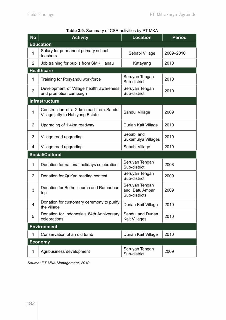
Field Findings
182
PT Mitrakarya Agroindo
Table 3.9. Summary of CSR activities by PT MKANo Activity Location PeriodEducation
1 Salary for permanent primary school teachers Sebabi Village 2009–2010
2 Job training for pupils from SMK Hanau Katayang 2010
Healthcare
1 Training for Posyandu workforce Seruyan Tengah Sub-district 2010
2 Development of Village health awareness and promotion campaign
Seruyan Tengah Sub-district 2010
Infrastructure
1 Construction of a 2 km road from Sandul Village jetty to Nahiyang Estate Sandul Village 2009
2 Upgrading of 1.4km roadway Durian Kait Village 2010
3 Village road upgrading Sebabi and Sukamulya Villages 2010
4 Village road upgrading Sebabi Village 2010
Social/Cultural
1 Donation for national holidays celebration Seruyan Tengah Sub-district 2008
2 Donation for Qur’an reading contest Seruyan Tengah Sub-district 2009
3 Donation for Bethel church and Ramadhan trip
Seruyan Tengah and Batu Ampar Sub-districts
2009
4 Donation for customary ceremony to purify the village Durian Kait Village 2010
5 Donation for Indonesia’s 64th Anniversary celebrations
Sandul and Durian Kait Villages 2010
Environment1 Conservation of an old tomb Durian Kait Village 2010
Economy
1 Agribusiness development Seruyan Tengah Sub-district 2009
Source: PT MKA Management, 2010

Field Findings
183
PT Mitrakarya Agroindo
3.7.3. Conclusions
Based on the above discussion, the study has drawn the following conclusions:
(1) The use of land for PT MKA’s oil palm plantation does not diminish the legal and traditional rights of the community in the surrounding area. Community land issues have been formally settled with compensation by the negotiation process, without intimidation, and witnessed and facilitated by village and sub-district officials. There was one case where a land owner did not want to release land to the Company although it is located inside the Company’s concession. The weakness of the process is in the fact that the Company did not involve community representatives when they set the compensation rate, but only involved each land owner.
(2) The last planting carried out by PT MKA was in 2010, thus the Company bears obligations under RSPO Criterion 7.3. In relation to HCV5 and HCV6, HCV6 component was identified in PT MKA’s area and its surroundings, especially in Durian Kait Village where a sacred tomb is honoured by the local community. Meanwhile, there is no indication of the existence of HCV5.
(3) New planting by PT MKA was conducted from 2006 to 2010 on community land that had been acquired by the Company through the legal process of compensation. All legal documents have been signed with revenue stamp affixed by both parties and co-signed by a village official. If local people and other stakeholders objected to the new planting, they could express their views through their own representatives. However, in reality, there were no objections from the community to the new planting.
(4) The Company paid compensation for community land that it acquired, and the process was carried out voluntarily without intimidation from anyone. There is a record of the identification and valuation of community land that involved local government institutions, i.e. village head and sub-district head. Records of the payment are kept by D&L division. So are the records of negotiation outcomes, the calculation and the payment. However, land owners who relinquished their land were not given copies of the documents. The people who had surrendered access and rights to their land have been given a chance to benefit from plantation development by working in the plantation if they are interested and meet the requirements set by the Company’s management. Thus, the land acquisition and release of rights over the land for plantation development were in line with RSPO Criterion 7.6.
(5) The existence of PT MKA has brought changes in community social life in the surrounding area, both negative and positive. Some of the positive impacts are: greater community concern for education and healthcare; improvement in infrastructure that has increased community mobility; changes in cognitive, affective and psychomotor behaviours of

Field Findings
184
PT Mitrakarya Agroindo
the community toward oil palm plantations; and the development of organisations and institutions such as the forming of a new sub-district, Batu Ampar, in February 2010 due to the population increase and economic growth of the area. Another positive impact is the higher social status of the community in Sandul Village as seen from the welfare indicators such as the condition of housing and ownership of secondary and tertiary goods.
(6) From an economic perspective, the impact of PT MKA has been more positive than negative. The positive impact includes employment opportunities for the local community and incoming migrants, business opportunities for the surrounding community and higher income for the community. On the negative side, less income is available from forest products (resin, wild rubber, etc.) and less fishing is possible because the fishing spot is part of the riparian area that belongs to the conservation area.
(7) Implementation of CSR by PT MKA in education and healthcare is considered good. The Company has conducted the following actions: financing a private kindergarten and elementary school under the management of PT MKA: providing the salary for non-permanent teachers of primary school; providing school transportation for children living near the plantation and children of the Company’s staff; providing transportation for field workers (by truck and by boat); and hosting job training for pupils from Hanau vocational school and students from INSTIPER. Meanwhile, CSR programmes in healthcare include assisting and empowering the Posyandu workforce; providing free medical checkups for community members; donating to the healthcare fund for the village head of Sebabi; and funding healthcare for INSTIPER students undergoing job training in 2010. In terms of empowering the local economy, the Company’s programme is still limited to cooperation with local contractors from the community in Sandul Village to transport crops and CPO. Only community members that own trucks can be involved in this scheme. Larger local economy empowerment in the form of a plasma scheme in plantation development has not been realised because the Company is still waiting for the finalisation of Provincial Spatial Planning of Central Kalimantan. The Company has given strong support for infrastructure development and maintenance as well as the celebration of public and religious holidays, but assistance in handling emergency situations is still not optimal.

Field Findings
185
PT Mitrakarya Agroindo
3.7.4. Recommendation
From the discussion of social impacts as well as the process and procedure of land release for PT MKA, the recommendations are as follows:
(1) During the measurement process, the Village Representative Board should be involved and present the legally proved owner of the land witnessed by owners of neighbouring lands. This will prevent social conflict subsequently if another person claims the land.
(2) To anticipate income reduction for members of the community who have relinquished their land to the Company, the Company should consider: (1) not buying highly productive land such as rubber plantations, fruit plantations or active farmlands; and (2) immediately establishing a plasma estate with the local people to preserve the connection between the community and their relinquished lands.
(3) There is no indication that the community is worried about the diminishing value of local customs due to interaction with outside community. Social behaviour in the community remains unchanged and customary rules and norms are still firmly held by the community. For example, the customary ceremony of manyanggar lewu is still preserved and practised. There is also an old tomb that has been declared HCV6. Therefore, the Company is expected to provide moral and financial support to preserve it.
(4) For the Company to be sustainable, it would be better to create a sense of belonging in the community or at least ensure that the community receives positive contributions from the Company. For that reason, the implementation of CSR should be directed toward empowerment programmes to form cognitive, affective and psychomotor changes by providing trainers who are competent in agribusiness.

Field Findings
186
PT Buana Adhitama
3.8. PT Buana Adhitama (BAT)
3.8.1. Company Profile
PT Buana Adhitama (BAT) was established in 2004 under Articles of Incorporation Number 10 dated 25 May 2004 issued by Notary Hardinawanti Surodjo, S.H. in Jakarta, and officially validated by Decree of the Minister of Justice Number C-30265.HT.01.01 dated 14 November 2005, and followed by three changes of Incorporation Act. The first change was Articles of Incorporation Number 14 dated 21 April 2004 by Notary Hardinawanti Surodjo, S.H. in Jakarta and approval for change of the Company statute to Articles of Association Number AHU-24065.AH.01.02 dated 8 May 2008; Number 93 and 24011, dated 18 November 2008. Secondly, it was changed to Articles of Incorporation Number 3 dated 9 January 2009 by Notary Hardinawanti Surodjo, S.H. in Jakarta and approval for change of the Company statute to Articles of Association Number AHU-AH.01.10-01519, dated 11 March 2009. Finally, it was changed to Articles of Incorporation Number 44, dated 18 March 2009 by Notary Hardinawanti Surodjo, S.H. in Jakarta and approval for change of the Company statute to Articles of Association Number AHU-AH.01.10-06978, dated 1 June 2009.
The Plantation Business License of PT BAT was issued by the head of Kotawaringin Timur District with Letter Number 525.26/210/III/EKBANG/2007, dated 6 March 2007, while the Land Permit was issued by the head of Kotawaringin Timur District with Letter Number 854.460.42, dated 30 December 2004, with the total area of 14,300 ha.
The plantation area and processing mill of PT BAT consist of a 2,575 ha production site and 11,725 ha for development and other uses. The total of 14,300 ha is located in Kotawaringin Timur District and distributed in the following villages: Bawan, Tumbang Tilap, Tanjung Jariangau and Tukang Langit which are located in Mentaya Hulu Sub-district; and Tumbang Sangai, Rantau Katang, Tumbang Mangkup, Rantau Tampang, Luwuk Kuan, Tumbang Bajanei and Tumbang Boloi located in Antang Kalang Sub-district.

Field Findings
187
PT Buana Adhitama
Based on data from Mentaya Hulu Sub-district in 2010, the population was 19,018 people or 5,009 households spread over 16 villages. The main occupations of the community are: 60% farmers (rattan and rubber); 10% company employees; 5% civil servants, police officers, soldiers; 7% traders and others (General Desciption of Mentaya Hulu Sub-district, Kotawaringin Timur, 2010).
As of December 2010, 2,090 ha of land had been cleared, while planted land was 1,853 ha. The first planting was carried out in 2007, and an area of 417 ha had begun to produce with average productivity of 6.7 tonnes FFB/ha per year.
The presence of PT BAT in Central Kalimantan Province has contributed jobs and opened business opportunities to the surrounding community. Based on data from the management of PT BAT, in 2010 the Company employed 479 workers, consisting of 67 plantation staff and 412 field workers.
Figure 3.77. Location of PT BAT

Field Findings
188
PT Buana Adhitama
Figure 3.78. Sapiri Estate PT BAT in Kotawaringin Timur District
3.8.2. Field Findings
These field findings are derived from Focus Group Discussion (FGD), in-depth interview, structured interview, Secondary Data Collection and Field Observation which were conducted for the community in PT BAT. Three sessions of FGDs were conducted in the three villages with a total of 41 participants. in-depth interviews were conducted with 14 informants consisting of informal leaders, custom leaders and farmers in the PT BAT concession. Structured interviews were done for 10 persons representing district officials, village officials, sub-village officials and company management.
3.8.2.1. RSPO Criterion 2.3
Based on FGDs, in-depth interviews with informal leaders and structured interviews with formal and informal leaders at the village and sub-district level, the findings are as follows:
(1) All cleared and planted land under PT BAT belonged to the community under traditional rights. Compensation for the land used by the Company was based on a negotiated rate that was accepted in a legally responsible manner. Records of negotiations between the Company and the community on the compensation rate could not be found in the possession of the Company, village office or community/land owners. However, the land owners acknowledged that the Company had paid compensation to them based on the final agreement.
(2) There was no documentary proof of the legal and traditional rights of these communities. There was no map with a proper scale and coordinates of the negotiated land. Claims of traditional ownership rights were determined based on plants cultivated on the land at that time and the testimonies of people who knew the rightful owner.
(3) Since the land boundaries were not clear, the Company, the land owner and village officials measured and drew a map of the land prior to the negotiation and compensation process.

Field Findings
189
PT Buana Adhitama
(4) Based on information from informal leaders at Tumbang Tilap, Tanjung Jariangau and Tumbang Keminting Villages, there were differences in the total area measured by the Company and the total area according to the land owners. This was because the total land area under traditional rights is usually estimated. However, such differences were solved by mutual agreement facilitated by village officials.
Figure 3.79. Measurement and mapping of community land
3.8.2.2. RSPO Criterion 7.3
Based on in-depth interviews, structured interviews and FGDs at three villages around PT BAT’s plantation, the study found:
(1) The first planting in PT BAT began in 2007, although the permit was obtained in 2004 and field activities started in 2005. Until recently, new planting is still ongoing on the remaining land for which permission has been obtained. The new plantings fall under the category of On-going New Planting. In this case, the Company did not plant on local community land, primary forest or HCV areas. The planting was done in degraded land, secondary forest left by the forest concession holder, and abandoned paddy fields or shrub land.
(2) PT BAT has documentation regarding the assessment of HCV which was conducted by the Faculty of Forestry of IPB from May to June 2010. Peer review of the HCV assessment was performed by Resit Sozer and was finalised in 2011. In 2010, the IPB Team also conducted historic HCV assessment.
3.8.2.3. High Conservation Value 5 (HCV5)
HCV5 refers to a forest area needed by the community to fulfil its basic needs. Originally, the village communities at Mentaya Hulu Sub-district and Antang Kalang Sub-district depended on forest areas around their villages. After the arrival of PT BAT, the community was no longer dependent on forest products, and turned to the market to supply necessities.

Field Findings
190
PT Buana Adhitama
When PT BAT started its operations in 2004 by using forest left by the forest concession, some members of the local community changed their livelihoods by becoming field workers and opening businesses such as grocery stores, transportation services and workshops, while others continued cultivating their paddy fields and rubber plantations.
The final report of HCV assessment for the PT BAT area was prepared in 2011. The report stated that there is no indication of HCV5 in the PT BAT plantation area.
Figure 3.80. Secondary forest in the background
3.8.2.4. High Conservation Value 6 (HCV6)
HCV6 refers to a forest area needed by the local community to preserve their cultural identity as well as their religion/beliefs. Based on information from the community and customary leaders, the three villages have forest areas that are traditionally considered sacred and protected by customary law since they are believed to be ancestral tombs and also a sanctuary for flora and fauna that are important to their religion beliefs.
Most of the local community consists of Dayak people. In Tanjung Jariangau, 90% of the population is Moslem, while in Tumbang Tilap and Tumbang Kemiting, 90% of the population is Hindu Kaharingan. Thus, in the latter two villages, sacred places are commonly found. Based on the assessment, the existence of HCV6 at villages located around PT BAT is explained in Table 3.10. below.
Table. 3.10. HCV6 at villages located around PT BAT Village HCV Area (ha)
Bukit Tempilak Holy tomb 0.03Maripung Altar/worship site 0.02Tumbang Keminting Pantar, worship site 0.01Tumbang Tilap Holy tomb and Sandung 0.05Source: Management of PT BAT, 2010

Field Findings
191
PT Buana Adhitama
The component of HCV6 in this area serves an important function in preserving the cultural identity of the local community. This finding is in line with the earlier HCV assessment.
The Company has responded positively by protecting components of HCV6 and not clearing or planting oil palm in the area or in the surrounding areas.
According to the Tumbang Keminting Village Secretary, head of Tumbang Tilap Village and informal leaders who have been involved in the land compensation process in these two villages, there was no claim on the land or forest area relating to customary rights, cultural interest and beliefs of the local community. The process of land compensation under the PT BAT concession was concluded without any claim regarding the presence of sacred land.
3.8.2.5. RSPO Criterion 7.5
Based on in-depth interviews, structured interviews, FGDs and supported by secondary data from PT BAT, the findings in relation to RSPO Criterion 7.5 are as follows:
(1) PT BAT has Social and Environmental Impact Assessment (SEIA) documents that were prepared in 2007. The preparation of the document involved members of the community who experienced the direct and indirect impact of the presence of PT BAT. Elements of the community involved in the preparation of SEIA documents were government officials at district, sub-district and village level; and informal leaders from villages around PT BAT such as religious leaders, organisation leaders and customary leaders. Community members were involved in the preparation of the SEIA documents. Community members at the district level were invited such as government officials and informal leaders from the surrounding villages of PT BAT. By doing so, PT BAT anticipated possible negative and positive impacts that could arise at present and in the future. The SEIA documents identify social, economic and environmental impacts, both positive and negative. In 2011, the Company also conducted an HCV assessment and public consultation at district level by inviting heads of related institutions, academics, sub-district heads, village heads, customary leaders and NGOs.
(2) Since PT BAT is considered a new palm oil plantation land preparation and planting are still ongoing, the socialisation of land preparation is done gradually by personally approaching the District Head, Sub-district Head, Village Head and the related institutions as well as mass socialisation in all the surrounding villages attended by government officials at the sub-district and village level. Records of the socialisation are kept by the Company; they consist of invitations to the socialisation activities, the socialisation documentation and the meeting attendance list.
(3) After the total area of land to be acquired was determined, the Company paid compensation according to the agreed rate, witnessed by village officials and sub-district officials.

Field Findings
192
PT Buana Adhitama
(5) Records of compensation payment were kept in the PT BAT office, but no copies were kept by the community, village office, compensation recipient or witnesses to the final agreement.
(6) Payment of compensation was complemented by the following documents: (a) Receipt of compensation payment affixed with revenue stamp and signed by
compensation recipient; (b) Official final agreement signed by the traditional land owner, the Company, village
head and sub-district head;(c) Land relinquishment statement signed by the land owner, village head and sub-
district head affixed with the appropriate revenue stamp; (d) Statement by the land owner who cultivated the land, signed by the land owner and
village head affixed with the appropriate revenue stamp;(e) List of witnesses signed by the witnesses, the land owner, Village Head and
measurement officer;(f) Photograph of the compensation recipient showing the value of compensation
received.
3.8.2.6. RSPO Criterion 7.6
Based on interviews and FGDs with the local community, relevant agencies, informal leaders, as well as community organisations located in villages around PT BAT, the findings relating to RSPO Criterion 7.6 are as follows:
(1) Identification of community members who had the right to receive compensation was started by claims submitted by the community to the management of PT BAT, either individually or collectively.
(2) PT BAT followed up by listing the land, mapping the land and preparing sketches of the land to be acquired and its boundaries to verify the above claims.
(3) After listing, checking and mapping, the identification process continued with confirmation
(4) The compensation rate was set by the community and the Company based on the condition of land, whether it was traditional land or cultivated land, and the existence of plants on the land.
Figure 3.81. Socialisation with the community around PT BAT before land preparation

Field Findings
193
PT Buana Adhitama
by the informal leaders and village officials as witnesses of the land ownership.(4) If the land was confirmed by witnesses, and the boundaries and cultivated plants were
ascertained, the Company would proceed with compensation.(5) One of the main requirements for identifying the compensation recipient is that the
community or individual who proposes the claim should attend the whole land identification process, from mapping and measurement to identification of evidence and witnesses of the land ownership.
(6) If evidence and witnesses to land ownership were not available, the compensation process would be stopped, and the Company would advise the land owner to proceed with the case in a court of law.
3.8.2.7. Socio-economic Impact
3.8.2.7.1. Social Impact
(1) Interaction Process
A community as a system always experience changes; the changes may come in the form of progress or regress. Members of the community inevitably interact with each other as a system. The interaction process in the community becomes more important in relation to development. During interaction, conflict may arise, as either personal conflict or group conflict.
The existence of the Company with its business activities has generated social impact on the Company itself and on the community. PT BAT has made many contributions to the improvement of the socio-economic condition of local people around the Company so that they can fulfil their needs. PT BAT has also influenced community’s living patterns through the re-orientation of asset ownership to obtain status and appreciation.
In the course of its journey, PT BAT had already formed consensus with the surrounding community and established harmonious cooperation by providing facilities needed by the community.
The presence of PT BAT has inevitably increased the mobility of people, whether migrants or the local communities surrounding the concession. Access roads have been opened for the surrounding villages as well as increased the mobility of people to and from other villages or the city. This is part of the development of social interaction within the community. So far, there is no indication of the existence of social conflicts between local people and migrants.
(2) Organisation and Social Structure
The local community around PT BAT has succeeded in developing various local social organisations such as youth organisations, family welfare organisations and the Village

Field Findings
194
PT Buana Adhitama
Representative Board. These organisations have contributed significantly to the development and maintenance of relationship among various groups in the community. The study team found that the Company did not have any formal relationship with these local organisations. However, company employees have maintained harmonious interaction with members of these organisations.
The presence of PT BAT has also had a positive impact on the mutual aid system (gotong royong) that still exists in the local community. However, societal changes tend to also change the form that mutual aid takes. With the increase of money circulating in society, aid now tends to take the form of monetary contribution.
PT BAT’s relations with the local community are well established, though there was initially conflict between those in favour and those against the plantation. But generally, PT BAT’s provision of access roads and employment opportunities have contributed in promoting good relations.
(3) Social Institutions
In the village governance system, the village is led by a Village Head, whose immediate supervisor, the sub-district head, is based in the capital of the sub-district. The Village Head is assisted by a secretary and other officers and in charge of several Neighborhood Councils and Neighborhood Groups. As the extension of the sub-district head’s authority, the village head is in charge of developing each village, such as Tilap, Tanjung Jariangau and Kaminting.
Problems either with PT BAT or among members of the community are settled by the Village Head, whereas problems related to customs are settled by the Damang (customary leader) who lives in the capital of the sub-district. Based on information from the community, the problem is resolved by mutual agreement and never involve the police or courts. Thus, the leadership in the government system has functioned properly in executing its duty.
There has been no significant changes to daily family life since PT BAT’s arrival, as the community is mostly focused on fulfilling daily needs. With current incomes, almost all families are able to fulfil their needs and own televisions and mobile phones. They also wear clothes of similar quality to those worn by visitors from other areas. Based on the study, children around PT BAT go to elementary school and enjoy healthcare services.
Respecting the beliefs/religion of local people working at the Company, PT BAT provides prayer rooms according to the needs of each religion. Most people from Tumbang Tilap are Moslems or Christians and the remainder are Kaharingan believers. At Tanjung Jaringau Village most people are Moslems, Christians and Kaharingan believers. At Kaminting Village most are Kaharingan believers, followed by Moslems and Christians. They live in harmony and never had religious conflict. Customary practices and laws are still preserved and serve

Field Findings
195
PT Buana Adhitama
as a means of social control. The execution of the law is in accordance with the respective religion. Customary practices and laws are considered social norms.
In terms of education, it was found that most community members at Tumbang Tilap, Tanjung Jairangau and Kaminting Village have access to education, as indicated by the long-established elementary school in each village. Children are therefore able to receive schooling in their own village.
PT BAT pays great attention to education. School transportation for children of company employees is provided. According to interview results, PT BAT also supports education at neighbouring villages: the Company donates textbooks and pays for a non-permanent teacher at Tumbang Tilap Village. Therefore, the presence of PT BAT has been helpful to schools located around the Company. In addition, PT BAT hosts job training for vocational school students. The cooperation between the Company and the community in education has had a positive impact that the Company constantly maintains.
PT BAT has also played an important role in creating job opportunities. Like any other oil palm plantation, the Company needs a large pool of labour for administrative and field work, especially during the planting and seedling seasons. These workers come from the surrounding area. As a result, unemployment and crime rates have decreased. This is in line with the result of interviews with customary and religious leaders which revealed that since PT BAT started operating, the village community feels more secure.
(4) Social Perception and Social Behaviour
Perception of the community toward the existence of the Company is varied. Those who perceive the existence of the Company positively do so because the Company creates employment and other opportunities. The community also receives compensation for their land which is located inside the Company’s plantation. There is no change in community behavior at Tumbang Tilap, Tanjung Jariangau and Kaminting, as can be seen from the strong relationship between the community members and the preservation of values, norms and customs in their daily lives.
Community perceptions toward the environment have shifted. Initially, they believed that the natural environment was sacred and should be protected, but now they believe it should be used responsibly to fulfil their needs and assist their economic development.
3.8.2.7.2. Economic Impact
The oil palm plantation development project has generated new income sources through employment. The activity has increased the income received by local people as well as migrants. PT BAT employs 492 workers, consisting of 13 plantation staff, 133 migrant staff
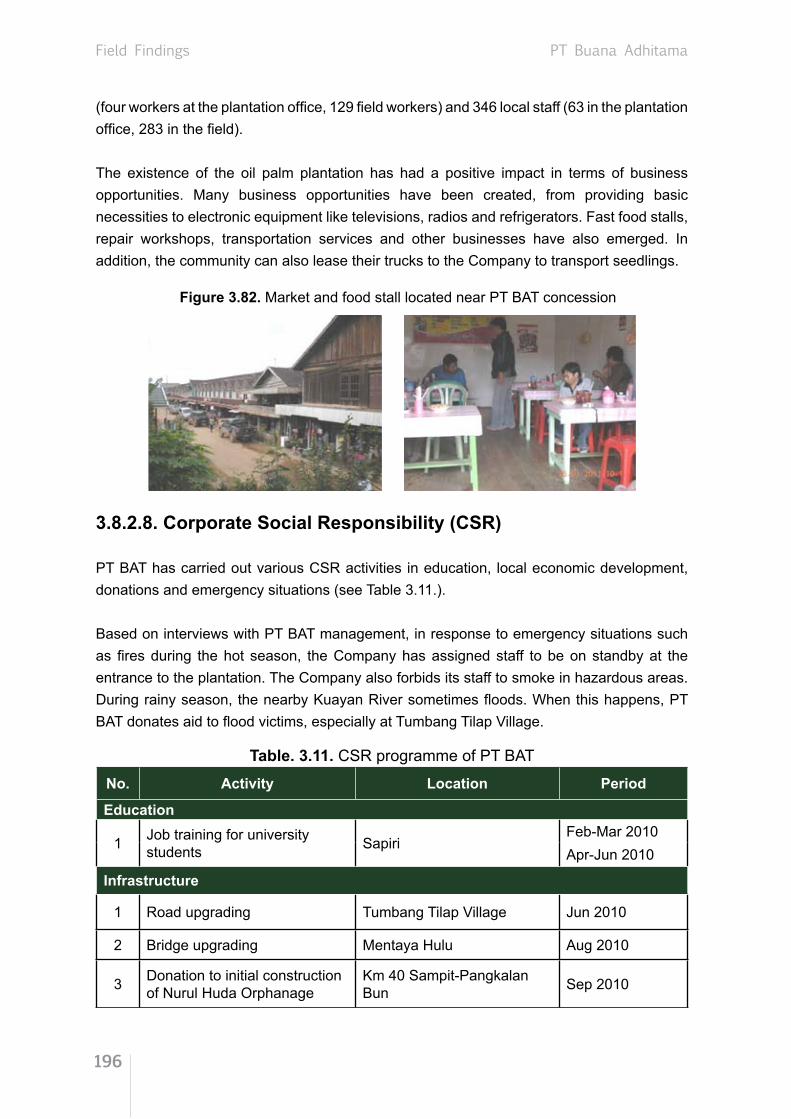
Field Findings
196
PT Buana Adhitama
(four workers at the plantation office, 129 field workers) and 346 local staff (63 in the plantation office, 283 in the field).
The existence of the oil palm plantation has had a positive impact in terms of business opportunities. Many business opportunities have been created, from providing basic necessities to electronic equipment like televisions, radios and refrigerators. Fast food stalls, repair workshops, transportation services and other businesses have also emerged. In addition, the community can also lease their trucks to the Company to transport seedlings.
Figure 3.82. Market and food stall located near PT BAT concession
3.8.2.8. Corporate Social Responsibility (CSR)
PT BAT has carried out various CSR activities in education, local economic development, donations and emergency situations (see Table 3.11.).
Based on interviews with PT BAT management, in response to emergency situations such as fires during the hot season, the Company has assigned staff to be on standby at the entrance to the plantation. The Company also forbids its staff to smoke in hazardous areas. During rainy season, the nearby Kuayan River sometimes floods. When this happens, PT BAT donates aid to flood victims, especially at Tumbang Tilap Village.
Table. 3.11. CSR programme of PT BAT
No. Activity Location Period
Education
1 Job training for university students Sapiri
Feb-Mar 2010Apr-Jun 2010
Infrastructure
1 Road upgrading Tumbang Tilap Village Jun 2010
2 Bridge upgrading Mentaya Hulu Aug 2010
3 Donation to initial construction of Nurul Huda Orphanage
Km 40 Sampit-Pangkalan Bun Sep 2010

Field Findings
197
PT Buana Adhitama
Economy
1 Contractor services for seedling transporation Tumbang Tilap Village Jan-Sep 2009
2 Contractor services for seedling transporation Bukit Santuai Apr-Dec 2009
3 Contractor services for seedling transporation From MNAE/NHY to SPRE Jan-Mar 2010
Source: PT BAT Management, 2010
3.8.3. Conclusions
(1) Land used by the Company has been acquired through the compensation process, preceded by negotiation over an acceptable compensation rate in a legally responsible manner. Records of the negotiation process between the Company and the community could not be found at the Company, village office or with the land owners. However, the land owners confirmed that negotiation of the compensation rate was carried out by the Company and land owners. There were no maps of negotiated land with proper scale and coordinates. The Company, land owner and village officer measured and mapped the land together before the negotiation process began.
(2) New planting by PT BAT started in 2007 although the permit had been obtained in 2004 and land preparation started in 2005. This new planting falls under the category of On-going New Planting. The Company did not plant on local community land that had not been acquired, in primary forest nor in any high conservation value area. Planting was carried out in secondary forest, degraded land, former logging sites, abandoned paddy fields and shrub lands. PT BAT has documentation of the HCV assessment conducted in 2010.
(3) No indication of HCV5 was found on the PT BAT concession, but HCV6 areas were found, in the form of sacred sites preserved by the community, such as an old tomb, altar/worship sites, pantar and sandung. The Company provides protection for these HCV6 areas.
(4) PT BAT has SEIA and HCV assessment documents, detailing the positive and negative impacts that the Company has had on the natural and social environment. These documents were prepared by consultants in collaboration with government officials and informal leaders. There are records of the socialisation process of the land preparation plan in the form of photographs and meeting attendance lists. The records of mutual agreement on the compensation for land released are complete and can be considered legally conclusive. They include the formal final agreement, receipt, copy of the identity card, photograph of the recipient and land ownership certificate.

Field Findings
198
PT Buana Adhitama
(5) Identification of compensation recipients began with community claims on land compensation followed by listing, mapping and measurement, confirmation by evidence and witnesses, and recommended compensation by the Company. Documentation of the compensation agreement is complete and can be legally supported. The documents include the final agreement, receipt, duplicate copy of identity card, photograph, and the relinquishment of land ownership. People who transferred their land to the Company were offered jobs working on the plantation if they wanted.
(6) The Company hires labourers from the local communities and migrants. It brings positive impact on the availability of the jobs opportunities and incomes. The presence of PT BAT has also had a positive impact on the development of business opportunities for the community.
(7) Since its arrival, PT BAT has built a harmonious relationship with the local community. The Company has opened access roads to surrounding villages and increased the mobility of the society. Social interaction in the community has increased and there is no indication of social conflict between locals and migrants.
(8) PT BAT has implemented CSR in terms of social activities in education, local economy, social contribution, and also emergency situations, by repairing the access road and bridge, creating seed transportation job contracts, and providing job training opportunities for students.
3.8.4. Recommendations
Based on the study, the recommendations are as follows:
(1) To reduce double claims for compensation from the community, the Company needs to improve its SOP on compensation by: a) ensuring there is adequate time for the individuals to evaluate the compensation; b) setting an agreed time limit for other claimants, if any, to step forward.
(2) PT BAT needs to provide more support to developing the local economy through cooperation and community engagement in its CSR programme.
(3) PT BAT has to pay more attention to the forest area held sacred by the local people. The Company should build a fence and install a signboard identifying it as a site of HCV6.

Conclusion
199
CONCLUSION 4
This study was coordinated by two senior researchers who led eight teams to conduct research on eight oil palm companies under the management of SMART. Three of the companies are located in West Kalimantan Province (PT Kartika Prima Cipta, PT Kencana Graha Permai and PT Agrolestari Mandiri) and five are in Central Kalimantan Province (PT Binasawit Abadi Pratama, PT Tapian Nadenggan, PT Satya Kisma Usaha, PT Mitra Karya Agroindo and PT Buana Adhitama).
Each research team had two researchers and two field assistants. In total, there were two persons in charge, one coordinating researcher, 16 researchers, 16 field assistants and two administrative assistants who were actively involved in the research. All the researchers are lecturers recruited from universities and the field assistants are senior agriculture students who have prior research experience with their lecturers.
During the fieldwork, the teams visited 28 (55%) of the 51 villages surrounding the companies’ concession and plasma estates, conducting 32 FGDs attended by a total of 350 participants, in-depth interviews with 136 interviewees and structured interviews with 202 people. The fieldwork lasted from November 2010 to March 2011.
Every team conducted its field work independently, from data collection and data analysis to report writing. The teams conducted the fieldwork with reference to identical study proposals and wrote the report following similar structures and components. The results of studies by the teams are compiled as separate sections in Field Findings (Chapter 3). Highlights of the Field Findings are summarised in this chapter as Conclusion and Recommendations.

Conclusion
200
4.1 Conclusion
4.1.1. RSPO Criterion 2.3 - Use of land for oil palm does not diminish the legal rights, or customary rights, of other users, without their free, prior and informed consent
Land acquisition by all eight companies under this study does not diminish legal rights and customary rights of other users, without their free, prior and informed consent. The negotiations were conducted between the Company and traditional land owners, but the negotiation process was not well documented.
There is no map of traditional land with appropriate scale that shows areas under customary rights. For negotiation purposes, the Company together with the land owner and the local village officials agreed to prepare land parcel maps which were mutually agreed.
The final settlement between land owners and the companies is documented with the final agreement signed by land owners, the companies and witnesses, and acknowledged by village heads and sub-district heads. Copies of the final agreement are kept by the Companies and were not provided to land owners and other parties.
The 2002 SOP of SMART does not mention the need for socialisation before inventory of the land that would be acquired. This study is of the view that socialisation should be a key component in the Company SOP. According to the 2010 SOP of SMART, socialisation activity is mentioned in the SOP on Land Use Title and SOP on Land Compensation, but not described in detail.
4.1.2. RSPO Criterion 7.3 - New plantings since November 2005, have not replaced primary forest or any area required to maintain or enhance one or more High Conservation Values
Land preparation for plantation development in the eight companies was not carried out in primary forest, but in secondary forest, degraded land, shrub land, former logging sites or forest concessions, land previously cleared by natural fire and land left by shifting cultivators. Especially for plantations in West Kalimantan, the locations of the plantations have met the requirements set forth in the spatial planning, being located on Area for Other Uses. Such practice was in line with the Decree of the Minister of Forestry and Plantation No. 259/Kpts-11/2000 on Designation of Forest and Aquatic Areas. As for Central Kalimantan Province, the location refers to the Provincial Regulation No. 8 of 2003 on the Provincial Spatial Planning of Central Kalimantan and is located in the Production Development Area or Area for Settlement and Other Uses.

Conclusion
201
There was no map of land preparation in accordance with identified HCV areas during the planning and implementation stages. Part of the land preparation and oil palm planting was conducted before HCV assessment as well as prior to the RSPO’s requirement in HCV assessment. All the companies carried out HCV assessments in early 2010, but by the time this study was conducted not all final reports of the HCV assessments had been completed.
4.1.3. High Conservation Value 5 (HCV5) - Natural areas critical for meeting the basic needs of local people
All eight companies under this study had already conducted HCV assessment. Areas of HCV5 were not found in the concessions of the five companies operating in Central Kalimantan, so an HCV5 management and monitoring plan is not required there. In contrast, HCV5 areas were identified in the concessions of the three companies in West Kalimantan in the form of springs for the local communities and agricultural land to meet their basic needs. These companies have already developed their own HCV5 management and monitoring plans. The local Dayak and Malay populations recognised that they share a commitment with the companies to carry out various activities to protect HCV5 areas against destructive exploitation.
Today, local populations have become less dependent on foraging in the surrounding forest to fulfil their basic needs as most of their daily staples are available at affordable prices in local markets. Development of oil palm plantations in the areas under this study has provided an important source of income for the local population, especially since previous sources of income such as logging are no longer capable of supporting the local economy. Most of the able males and females from surrounding communities work as labourers and contractors in various activities created by the Companies, such as loading and unloading, land preparation, planting, spraying and harvesting. Local communities also benefit from the multiplier effects of plantation operations.
4.1.4. High Conservation Value 6 (HCV6) - Areas critical for maintaining the cultural identity of local communities
HCV6 areas found in Central Kalimantan and West Kalimantan consist of sacred places and burial sites. The Companies have paid attention to HCV6 by managing burial sites and protecting sacred places against disturbance. However, some members of the community still claim that land preparation in the past trespassed on the burial sites of their ancestors.

Conclusion
202
4.1.5. RSPO Criterion 7.5 - No new plantings are established on local peoples’ land without their free, prior and informed consent, dealt with through a documented system that enables indigenous peoples, local communities and other stakeholders to express their views through their own representative institution
New planting in all eight companies under this study was conducted with prior approval from the local people.
It is a common practice that land owners are free to express their views on land acquisition and compensation payment. However, there is no representative institution chosen by land owners that negotiates on behalf of them.
All the Companies under the study already have a Social and Environmental Impact Assessment (SEIA) document, Environmental Management Plan and Environmental Monitoring Plan in their possession. The three documents were prepared by consultants and endorsed by the government, and the communities were engaged during their preparation. However, the monitoring report for the SEIA results is not yet complete, as it only reports the monitoring of water quality and does not cover social aspects.
The Companies had already conducted socialisation prior to new plantings, but the socialisation process was not well documented. In addition, the materials for socialisation have not included a cost-benefit analysis that compares the merits of relinquishing the land for oil palm development versus retaining it for other uses.
The final agreement on land relinquishment/compensation between land owners and the companies are available. However, copies of the final agreement are kept by the Companies and not provided to land owners.
The 2010 SOP for Land Compensation does not mention clearly whether land owners are allowed to select their own representative institutions to represent them in negotiations with the Company, although in practice land owners often appoint their relatives to represent them in negotiations.
4.1.6. RSPO Criterion 7.6 - Local people are compensated for any agreed land acquisitions and relinquishment of rights, subject to their free, prior and informed consent and negotiated agreement
The study found that identification and evaluation of land ownership based on legal and traditional land rights were already conducted. Compensation payment was discussed through negotiations between Companies and traditional land owners witnessed by local

Conclusion
203
government representatives. Although this negotiation process was not well documented, the final agreement was recorded in a legal release document kept by the Companies but not provided to land owners and other parties.
Individual land rights are determined in a number of ways: (1) Land Certificate issued by the National Land Agency; (2) Land Registration Form issued by sub-district head; (3) Land Registration Form issued by village head, and (4) Acknowledged Land Right. The last category of individual land right is determined by the express acknowledgment of the Village Head before witnesses who represent the land owner. If the individual land falls under the traditional right category, the acknowledgement from the Adat Chief and Village Head is required. When there is doubt about the exact size and location of the land, additional information can be collected from fellow villagers and neighbours of the land claimant.
The process for determining land compensation can be divided into the following steps: (a) receiving the express agreement of village representatives to relinquish the land; (b) identifying the size and location of the land as well as the cultivated plants; (c) clarifying the ownership with owners of the neighbouring land, indigenous leaders who are knowledgeable of land history and the related village head; (d) putting the results of identification in maps called peta rincik (land parcel map); (e) negotiation of compensation with land owners or their representatives. The amount of compensation paid to land owners varies from one company to another.
Different negotiation methods were adopted: (a) The Company sets a range within which negotiation is made with due consideration of characteristics of the land including compensation for planted vegetation and negotiates with the land owners until an agreement is reached; (b) The Company sets out the price and the land owners decide whether they agree to accept the offer or not; (c) The Company negotiates with the village and sub-district head who represents land owners to determine land compensation in the sub-district/village and then negotiates with the land owners who decide whether to accept the offer or not.
Payment of compensation was made in cash. Proof of compensation payment consisted of a receipt attached to the final agreement, land release document, photograph of the land owner and land parcel map. Final agreement and land release document should be signed by representatives of the Company, land owners and witnesses, and acknowledged by the village head and sub-district head. All the documents were kept by the Company and not disseminated to land owners and other parties.
Villagers who no longer have access to and rights over land for oil palm plantation are given the opportunity to work at the Company, to provide services as local contractors and/or to join the plantation plasma scheme.

Conclusion
204
4.1.7 Social Impact Assessment
The presence of the Companies in the rural area creates positive impacts on surrounding areas, such as creating new jobs for the local population, increasing local people’s income, increasing the circulation of cash in the rural market and stimulating the growth of business.
Road construction and maintenance have increased accessibility to rural areas, the mobility of people and goods and improved connectivity between urban and rural areas and between towns and villages. The study found changes related to social interaction, social structure and organisation, social institutions and social perception. There were concerns among local people in Central Kalimantan Province that the influx of outsiders might irreversibly alter their cultural identity. The study found that the structure and characteristics of the social elements are changing naturally following the dynamics of development in the region and the nation.
The presence of oil palm development in the rural area, however, has introduced new variables in socio-economic development. Social goods that previously were passed around quite freely among members of the community without charge, e.g. land, labour and services, are now changing status into economic goods that require formal methods, procedures and economic value. Such transformations have been internalised by rural communities to different degrees and at different speeds, often creating various challenges.
4.1.8 Corporate Social Responsibility (CSR)
The research team found that the Companies had conducted various activities with their CSR projects in the sectors of infrastructure, health, education, emergency response and local economy empowerment. Such activities can still be classified as ad-hoc in nature, and not as part of a well-planned, long-term and sustainable CSR programme which addresses strategic issues.
4.1.9. Plasma Estates for Local Communities
According to Article 11 Paragraph 1 of Decree of the Minister of Agriculture No. 26 of 2007 on Guidance for Plantation Permits, a company that owns a Plantation Business License or Plantation Business License type B is required to develop at least 20% of the total plantable areas as a plasma estate for local communities. In Central Kalimantan, plasma estates have not been created because the General Spatial Planning of Central Kalimantan Province has not been enacted by the government. Consequently, the location of the plasma estates has yet to be determined and there are difficulties getting banks to finance them.
In West Kalimantan Province, the Companies experience a different problem regarding the basis for plasma estates. The land owners insist that the 20% quota for plasma estate be built inside areas under the Company’s Land Use Title while the Company has explained

Conclusion
205
that the plasma estate should be established outside that area. This is in accordance with a circular issued by the Director General of Plantation Department, Ministry of Agriculture No. 396/02.140/31.1/07/207 dated 25 July 2007 on Interpretation of Article 11 Paragraph (1) of the Decree of the Minister of Agriculture No. 26 of 2007. This circular confirms that the 20% quota is to be developed outside areas under the Company’s Land Use Title, but the community still does not accept that.
Another problem relates to what constitutes the total plantable area, of which 20% will be devoted to plasma estates. The Companies exclude HCV areas from the total plantable area, pursuant to Article 11 Paragraph 1 of Decree of the Minister of Agriculture No. 26 of 2007. On the other hand, the community is of the view that the total plantable area should include all land that the Company receives from the community.
The incidence of boundary disputes between adjacent villages has also prevented the development of plasma estates. This is the case for PT ALM, and the Company is still awaiting agreement between the villages involved in the disputes.
4.2. Recommendations
4.2.1. Recommendations on SOP Improvement
(1) The 2010 SOP of SMART mentions socialisation activity in the SOP on Land Use Title and SOP for Land Compensation, but does not describe it in detail. The Research Team recommends making documentation of the socialisation process a key component of SMART’s SOP. The SOP should be adapted to clearly state the process of socialisation that will be used, including the procedures, the type of information and materials to provide to the parties involved, the process of discussion, and agreement, as well as documentation of the entire socialisation process.
(2) The 2010 SOP of SMART for HCV Assessment and Management does not explain each HCV clearly. The Research Team suggests that SOP be drawn up for individual HCVs, as each HCV requires different management and monitoring measures.
(3) The 2010 SOP of SMART for Land Compensation does not mention clearly whether land owners are allowed to select their own representative institutions to represent them in negotiations with the Company. The Research Team suggests the statement that “land owners are permitted to select their own representative institutions in negotiations with the Company” should be added to the SOP.

Conclusion
206
(4) The 2010 SOP of SMART for Land Compensation requires a land information letter as proof of ownership. However, it does not specify the types of land information letter that are acceptable. To clarify, the Research Team suggests the use of “Land Registration Form issued by the sub-district head or village head”.
(5) In order to design CSR programmes which respond to the long-term needs of the community and the Company on a sustainable basis, the Research Team suggests that the Company formulate SOP on CSR programmes.
(6) It was found that there has been no standard guideline regarding development of Plasma Estates. Therefore, the Research Team suggests that the Company formulates SOP on Plasma Estate Establishment in reference to Decree of the Minister of Agriculture No. 26 of 2007.
4.2.2. Recommendations on Other Aspects
(1) It is recommended that CSR programmes be designed conceptually and with a participatory approach based on local resources, empowerment of the local economy, development of strategic potential, sustainability and the needs of the community. CSR activities should not be limited to special occasions and donations.
(2) With regard to disagreement over the result of HCV assessment, for example between PT KPC and the Fauna and Flora International-Indonesia Programme, the Research Team suggests that the Company should develop a resolution process to address such issues.
(3) Particularly for Central Kalimantan, the Research Team suggests that the Company start to prepare SOP for the development of the Plasma Estates while awaiting completion of the revised Provincial Spatial Planning of Central Kalimantan.
(4) With regard to the boundary disputes between adjacent villages, the Research Team recommends that the Company encourage local government to expedite the resolution so as not to impede the development of the plantation, especially the plasma estates.
(5) Regarding the different interpretations of the 20% quota for plasma estate, the Research Team suggests that the Company improve its public communications and conduct a more intensive socialisation to explain the government regulations.
(6) Concerning wages for labour, the Research Team suggests that the Company reconsiders the wages paid to non-permanent labour, as well as wages and benefits received by permanent labour.

Conclusion
207
(7) To enhance local economic empowerment and ensure a more harmonious relationship between the Company and the communities, the Research Team recommends that the Company assigns a special staff to be in charge of social, economic and environmental issues.

References
208
REFERENCES
Allaby, M. 2006. Tropical Forest: Biomes of the Earth. Chelsea House. USA.
Asdak, Chay. 1995. Hidrologi dan Pengelolaan DAS. Penerbit Gadjah Mada University Press – Cetakan Pertama.
Authenticity Consulting, LLC. 2010. “Basic of Conducting Focus Groups”. http://managementhelp.org/evaluatn/focusgrp.htm 11/21/2010
Babbie, Earl. 1983. The practice of Social Research, Third Edition. Belmont, California: Wadsworth Publishing Company.
Badan Planologi Kehutanan. 2008. Rekalkulasi Penutupan Lahan Indonesia Tahun 2008. Pusat Inventarisasi dan Perpetaan Badan Kehutanan. Departemen Kehutanan.
Badrun, M. 2010a. Lintasan 30 Tahun Pengembangan Kelapa Sawit. Direktorat Jenderal Perkebunan Kementerian Pertanian Republik Indonesia, Jakarta.
Badrun, M. 2010b. Tonggak Perubahan Melalui PIR Kelapa Sawit Membangun Negeri. Direktorat Jenderal Perkebunan Kementerian Pertanian Republik Indonesia, Jakarta.
Bailey, Kenneth D. 1978. Methods of Social Research, Second Edition. London: The Free Press.
Boyce, Carolyn and Palena Neale. 2006. Conducting In-depth Interviews: A Guide for Designing and Conducting In-depth Interviews for Evaluation Input. Paithfinder International.
BPS dan BAPPEDA. 2009. Kabupaten Kapuas dalam Angka Tahun 2009. Badan Pusat Statistik Kerjasama dengan BAPPEDA Kabupaten Kapuas Hulu
Chong, Gabriel. 17 Nov 2010. “Challenges Toward Sustainable Oil Palm Post RT8. http://www.csr-asia.com/weekly_detail.plp?id=12198
Colchester, Marcus. Free, Prior, Informed, Consent [FPIC]. A field guide for activists, Forest Peoples Programme
Colchester, Marcus. Keputusan dini tanpa paksaan berdasarkan informasi lengkap sejak awal (Free, Prior and Informed Consent) Panduan Bagi Para Aktivis. Diterbitkan oleh :Pengurus Besar AMAN.
Colchester, Marcus and Fergus MacKay. 2004. In Search of Middle Ground: Indigenous Peoples, Collective Representation and the Right to Free, Prior and Informed Consent, Forest Peoples Programme, Moretonin-Marsh
Colchester dan Ferrari. 2007. Making FPIC work: Challenges and Prospects For Indigenous Peoples. Forest People Programme (FPP).
Collin, P.H. 2004. Dictionary of Environment & Ecology. Bloomsbury Publishing Plc. London, UK.
Goodman, N.and G. T. Marx. 1978. Society Today, Third Edition. New York: Random House.
Greenpeace. 6 July 2010. How Sinar Mas is Pulping the Planet (Greenpeace Publication) http://www.greenpeace.org
Guidance Note 11. 2003. “Social Impact Assessment”.http://www.proventionconsortium.orgthemes/default/pdfs/tools_for_mainstreaming-GN11.pdf
HCV Resource Nertwork. 2005. The High Conservation Value. http://www.hvcnetwork.org
HCV-RIWG. 2009. Pedoman Pengelolaan dan Pemantauan Nilai Konservasi Tinggi (NKT) Untuk Produksi Minyak Sawit Berkelanjutan di Indonesia Versi Draft Pertama, September 2009
IDRC Books. 2010. Modul 10C: Focus Group Discussion (Document 16 0f 27). http://idrc.ca/cp/ev-56615-201-1 DO_TOPIC.HTML 21/11/2010

References
209
Konsorsium Revisi HCV Toolkit Indonesia. 2008. Panduan Identifikasi Kawasan Bernilai Konservasi Tinggi di Indonesia. Version 2 June 2008. Jakarta.
Lauer, Robert. H. 2003. Perspektif Tentang Perubahan Sosial. Jakarta: Rineka Cipta.
Leistritz, F. Larry and Steven H, Murdock. 1981. The Socio-economic Impact of Resource Development: Methods for Assessment (Social Impact Assessment Series, No. 6). Boulder Colorado: Westview Press.
Lesmana, T. 2006. “Program Corporate Social Responsibility Yang Berkelanjutan”. Majalah Lensa ETF. Edisi 1, November 2006. Eka Tjipta Foundation.
Maggie, Max. 15 Nov 2010. “Hak Ulayat: Dihormati, Diingkari”. Harian Umum Sinar Harapan, Rabu 08 April 2009.http://www.sinarharapan.co.id/berita/0904/08/op01.html
Miles, Matthew B and A. Michael Huberman. 1984. Qualitative Data analysis : A Sourcebook of New Methods. Fourth Printing. Beverly Hills: Sage Publication
Murdock, S.H. and E. C. Schriner. 1978. “Structural and Distributional Factors in Community Development”. Rural Sociology 43 (3): 426-449.
Nasution, Bismar. 2008. Aspek Hukum Tanggung Jawab Sosial Perusahaan, Makalah disampaikan pada “Semiloka Peran dan Tanggung Jawab Sosial Perusahaan Terhadap Masyarakat Lokal Wilayah Operasi Perusahaan Perpspektif Hak Asasi Manusia” diselenggarakan oleh Komisi Hak Azasi Manusia Riau. Pekanbaru 23 Februari 2008.
Popenoe, David. 1978. Sociology, Fourth Edition. Englewood Cliff, N.J.: Prentice Hall.
Primack, R. and R. Corlett. 2005. Tropical Rain Forests: An Ecological And Biogeographical Comparison. Blackwell Publishing. USA
Purwo Susanto, Dwi Rahmad M, Didik Prasetyo dan Mohammad Rosidi. 2005. Penilaian Awal HCVF di Perkebunan Kelapa Sawit PT. Binasawit Abadi Pratama Kabupaten Seruyan, Kalimantan Tengah. Forest Conservation Initiatif Program.Yayasan WWF Indonesia.
Pusat Litbang Sumberdaya Air (SDA). 2010. Pengelolaan Danau dan Waduk di Indonesia. Kementerian Pekerjaan Umum RI.
Radyati, Maria Nindita. 2011. “Salah Kaprah CSR”. Harian Sinar Harapan. Rabu 13 April 2011. Hal. 16.
Rainforest Alliance dan ProForest. 2003. Mengidentifikasi, Mengelola dan Memantau Hutan dengan Nilai Konservasi Tinggi: Sebuah Toolkit untuk Pengelola Hutan dan Pihak-pihak Terkait Lainnya. Jakarta
Saleh, Ridha M. 2007. Masyarakat Adat dan Hak Ekonomi Sosial dan Budaya. Makalah Advanced Training Hak-hak Masyarakat Adat bagi Dosen Pengajar HAM di Indonesia. PUSHAM-UII Yogyakarta : 21-24 Agustus 2007.
Samson, Oliver. 2010. “The Pros and Cons Of Oil palm”. http://www.dw-world.de/dw/article/0,,5072916,00.html 10/26/2010.
Sanderson, Stephen. K. 2003. Makro Sosiologi: Sebuah Pendekatan Terhadap Realitas Sosial. Diterjemahkan oleh: Hotman M. Siahaan. Jakarta: PT. RajaGrafindo Persada.
Sirait, Martua T. 2009. Masyarakat Adat dan Ekspansi Perkebunan Kelapa Sawit di Kalimantan Barat, Indonesia. Fakultas Hukum Universitas Amsterdam dan didanai oleh Cordaid.
Siregar, Chairil N. 2007. “Analisis Sosiologis terhadap Implementasi Corporate Sosial Responsibility Pada Masyarakat Indonesia”. Journal Sosioteknologi Edisi 12 tahun 6, Desember 2007, hal. 285-288.
Sugiyanto. 2002. Lembaga Sosial. Penerbit Global Pustaka Utama. Jogjakarta.
Sumardjono, Maria S. W. 2010. “Harmonisasi Kedudukan Hak Ulayat dalam Peraturan Perundangan Indonesia”. http://tanobatak.wordpress.com 28 March 2010
Susanto, P. A. S. 1983. Pengantar Sosiologi dan Perubahan Sosial. Jakarta: Binacipta.
Stewart, C. Perpetua George, Tim Rayden and Ruth Nussbaum. 2008. Good Practice Guidelines for High Conservation Value Assessments. A Practical Guide for Practitioners and Auditor. ProForest, First edition, July 2008. Oxford. UK.http://www.sociology.org.uk/methsi.pdf. “Structure Interview.” 26 October 2010
Sztompka, P. 1993. Sosiologi Perubahan Sosial. Jakarta: Prenada. White, David (1994). Defining Old Growth: Implications For Management. Eighth Biennial Southern Silvicultural Research Conference.
The IVEX Report, 10 August 2010.

References
210
Thompson, J. G., E.L. Blevin, and G. L. Watts. 1978. Socio-economic Monitoring Report. Washington, D.C.: Old West Regional Commission.Diakses dari http://www.treesearch.fs.fed.us/pubs/741.
Walgito, Bimo. 2007. Psikologi Sosial (Suatu Pengantar). Penerbit Andi. Jogjakarta.
Wibisono, Yusuf. 2007. Membedah Konsep dan Aplikasi CSR (Corporate Social Responsibility). Penerbit Fascho Publishing. Gresik.
Widodo, Sri. 2008. Campur Sari Agro Ekonomi. Yogyakarta: Liberty
Wikipedia. 31 October 2010, “Corporate Social Responsibility”.http://en.wikipedia.org/wiki/Corporate_social_responsibility
Wikipedia. 2011. Mintakat Riparian. Eksiklopedia Bebas
Regulation/Guidance/Report:
Badan Pusat Statistik Kabupaten Ketapang. 2009. Kecamatan Nanga Tayap Dalam Angka Tahun 2009.
BSI-CUC. 2010. Verifying Greenpeace Claims. Case: PT. Smart Tbk. Agustus 2010
Colchester, Marcus. 2008. Persetujuan Bebas, Didahulukan dan Diinformasikan dan The Roundtable on Sustainable Palm Oil. Disusun oleh Marcus Colchester – Director Forest Peoples Programme. Sebuah Panduan untuk Perusahaan Tahun 2008.
Rencana Pembangunan Jangka Menengah Desa (RPJMDes) Desa Rungau Raya Tahun 2011-2015. Desa Rungau Raya, Kecamatan Danau Saluluk Kabupaten Seruyan.
Republik Indonesia. 1945. Undang Undang Dasar RI Tahun 1945 pasal 1.3 dan pasal 3.
Republik Indonesia. 1960. Undang-Undang No. 5 Tahun 1960 tentang Pokok-pokok Agraria.
Republik Indonesia. 1996. Peraturan Pemerintah No. 40 Tahun 1996 tentang HGU, HGB dan HP.
Republik Indonesia. 1997. Peraturan Pemerintah R.I No 24 Tahun 1997 Tentang Pendaftaran Tanah.
Republik Indonesia. 1999. Undang-Undang No. 22 Tahun 1999 tentang Pemerintah Daerah. Jakarta.
Republik Indonesia. 1999. Undang-Undang No. 41 Tahun 1999 Tentang Kehutanan. Republik Indonesia. Jakarta Republik Indonesia. 2000. Peraturan Pemerintah No. 25 Tahun 2000 tentang Kewenangan Pemerintah di Bidang Pertanahan. Jakarta.
Republik Indonesia. 1999. Permen Agraria/Kep. BPN No. 5 Tahun 1999 tentang Pedoman Penyelesaian Masalah Hak Ulayat Masyarakat Hukum Adat.
Republik Indonesia. 1999. Keputusan Menteri dalam Negeri Nomor 64 Tahun 1999 Tentang Pedoman Umum Tentang Pengaturan Mengenai Desa. Jakarta.
Republik Indonesia. 2002. Prosedur Perolehan Hak atas Tanah. Disusun oleh ITDV-System Departement Tahun 2002.
Republik Indonesia. 2003. Keputusan Presiden No. 34/2003 tentang Kebijakan Nasional di Bidang Pertanahan. Jakarta.
Republik Indonesia. 2004. Undang-Undang No. 7 Tahun 2004 Tentang Sumberdaya Air.
Republik Indonesia. 2004. Undang-Undang Nomor 18 Tahun 2004 Tentang Perkebunan.
Republik Indonesia. 2004. Undang-Undang Republik Indonesia Nomor 32 Tahun 2004 Tentang Pemerintahan Daerah.
Republik Indonesia. 2006. Peraturan Bupati Ketapang No.6 Tahun 2006 tentang Ganti Rugi Tanam Tumbuh di Kabupaten ketapang.
Republik Indonesia. 2006. Peraturan Menteri Pertanian Nomor: 33/Permentan/OT.140/7/2006 Tentang Pengembangan Perkebunan Melalui Program Revitalisasi Perkebunan.
Republik Indonesia. 2007. Undang-Undang Nomor 40 Tahun 2007 tentang Perseroan terbatas.
Republik Indonesia. 2007. Peraturan Menteri Pertanian No. 26/Permentan/OT.140/2/2007 Tentang Pedoman Perijinan Usaha Perkebunan. Departemen Pertanian Republik Indonesia. Jakarta.

References
211
Republik Indonesia. 2007. Surat Direktur Jenderal Perkebunan tahun 2007 No. 396/OT.140/E1.1/07/2007 Tentang Penjelasan Pasal 11 ayat (1) Permentan No. 26 Thn. 2007.
Republik Indonesia. 2009. Peraturan Ditjen Rehabilitasi Lahan dan Perhutanan Sosial (RLPS) Dephut RI No. P.04/V-SET/2009 tanggal 05 Maret 2009 tentang Pedoman MONEV DAS.
Republik Indonesia. 2009. Surat Keputusan Bupati Ketapang Nomor 39 Tahun 2009 tanggal 6 Februari 2009 tentang Perpanjangan Izin Lokasi Pembangunan Perkebunan Kelapa Sawit dan Pabrik Pengolahan atas nama: PT. ALM.
Republik Indonesia. Surat Bupati Ketapang No. 525/1436/Bappeda-D tentang Revisi Informasi Lahan Perkebunan Kelapa Sawit PT. KGP Kecamatan Marau Kabupaten Ketapang.
Roundtable on Sustainable Palm Oil Indonesian National Interpretation Working Group (RSPO INA-NIWG). 2008. Interpretasi Nasional Prinsip dan Kriteria Untuk Produksi Minyak Sawit Berkelanjutan Republik Indonesia. Dokumen Final Mei 2008.
Roundtable on Sustainable Palm Oil Indonesian National Interpreation Working Group (RSPO INA-NIWG). 2008. National Interpretation of RSPO Principles and Criteria for Sustainable Palm Oil Production Republic of Indonesia.
The UN Declaration on the Rights of Indigenous Peoples, Treaties and the Right to Free, Prior and Informed Consent: The Framework For a New Mechanism for Reparations, Restitution and Redress, Submitted by the International Indian Treaty Council as a Conference Room Paper for the United Nations Permanent Forum on Indigenous Issues Seventh Session UNPFII7) 9 March 2008
The RSPO “Principles, Code of Conduct and Criteria”. 2006. (www.rspo.org)
Company Document
Analisis Dampak Lingkungan Hidup (ANDAL) Pembangunan Perkebunan dan Pabrik Pengolahan Kelapa Sawit PT. Mitrakarya Agroindo di Kecamatan Seruyan Tengah dan Kecamatan Hanau, Kabupaten Seruyan, Propinsi Kalimantan Tengah. 2007
Dokumen AMDAL PT. Kartika Prima Cipta Tahun 2007.
Laporan Hasil Pemantauan Pelaksanaan RKL & RPL PT. Kartika Prima Cipta, Periode Juli – Desember 2010.
Laporan Identifikasi dan Pengelolaan Nilai Konservasi Tinggi. Kabupaten Kotawaringin Provinsi Kalimantan Tengah. 2010
Laporan Identifikasi dan Pengelolaan Nilai Konservasi Tinggi (NKT), Unit Hanau Estate (PT. Tapian Nadenggan) Kabupaten Kotawaringin Timur, Kalimantan Tengah. 2010.
Laporan Identifikasi dan Pengelolaan Nilai Konservasi Tinggi (NKT), Unit Langadang Estate. Kabupaten Kotawaringin Timur, Kalimantan Tengah. 2010.
Laporan Identifikasi dan Pengelolaan Nilai Konservasi Tinggi (NKT), Unit Tanjung Paring Estate (PT. Tapian Nadenggan) Kabupaten Kotawaringin Timur, Kalimantan Tengah, 2010.
Laporan Identifikasi dan Pengelolaan Nilai Konservasi Tinggi (NKT), Unit Tasik Mas Estate. (PT. Tapian Nadenggan) Kabupaten Kotawaringin Timur, Kalimantan Tengah. 2010.
Laporan Identifikasi NKT (HCV) dan Pengelolaannya Perkebunan Kelapa Sawit PT. Mitrakarya Agroindo Kabupaten Seruyan, Provinsi Kalimantan Tengah. 2010.
Laporan Identifikasi Kawasan Bernilai Konservasi Tinggi Perkebunan Kelapa Sawit PT. Kartika Prima Cipta Kabupaten Kapuas Hulu Kalimantan Barat. Fauna & Flora International – Indonesia Program. April 2010.
Laporan Identifikasi Kawasan Nilai Konservasi Tinggi Pada PT. Agrolestari Lestari Mandiri, Kecamatan Nanga Tayap, Kabupaten Ketapang. 2010.
Laporan Rencana Pengelolaan dan Pemantauan KBKT di Areal Ijin PT. KGP Provinsi Kalimantan Barat, Kerjasama PT KGP dengan Fakultas Kehutanan IPB, 2010.
Laporan RKL Perkebunan dan Pabrik Pengolahan Kelapa Sawit PT. KGP Kecamatan Marau Kabupaten Ketapang Provinsi Kalimantan Barat, 2009.
Laporan RPL Perkebunan dan Pabrik Pengolahan Kelapa Sawit PT. KGP Kecamatan Marau Kabupaten Ketapang Provinsi Kalimantan Barat, 2009.
Laporan Studi Analisis Dampak Lingkungan (ANDAL) Perkebunan Kelapa Sawit PT. Satya Kisma Usaha di Desa Medang Sari Kecamatan Arut Selatan; Kabupaten Kotawaringin Barat; Propinsi Kalimantan Tengah. 2003

References
212
Laporan Utama Analisis Dampak Lingkungan. 2007. PT ALM Kecamatan Nanga Tayap Kabupaten Ketapang Provinsi Kalimantan Barat.
Laporan Utama Analisis Dampak Lingkungan. 2007. PT ALM Kecamatan Nanga Tayap Kabupaten Ketapang Provinsi Kalimantan Barat.
Laporan Utama ANDAL Perkebunan dan Pabrik Pengolahan Kelapa Sawit PT. KGP Kecamatan Marau Kabupaten Ketapang Provinsi Kalimantan Barat, 2009.
Laporan Utama Analisis Dampak Lingkungan (ANDAL) Perkebunan dan Pabrik Kelapa Sawit PT. Binasawit Abadi Pratama di Kecamatan Danau Sembuluh, Seruyan Tengah dan Hanau; Kabupaten Kotawaringin Timur; Propinsi Kalimantan Tengah.
Laporan Utama Analisis Dampak Lingkungan (ANDAL) Perkebunan dan Pabrik Kelapa Sawit PT. Tapian Nadenggan di Kecamatan Seruyan Tengah dan Hanau; Kabupaten Seruyan; Provinsi Kalimantan Tengah.2010.
SOP Ganti Rugi Tanah/Lahan PT. SMART Tbk. 2002. Central D & L, PT. Smart Tbk.
SOP Ganti Rugi Tanah/Lahan No. SOP/NP/SMART/VII/D&L002 1 juli 2010 Disusun oleh PT. Smart Tbk.

Glossary
213
Terminology Description
Agricultural Extension OfficerPenyuluh Pertanian Lapangan (PPL) –the Ministry of Agriculture staff responsible for providing education and guidance in agriculture sector at village level
Area for Other Uses
Area Penggunaan Lain (APL) forest area which is classified as non-forest area based on the Minister of Forestry Decree on Designation of Forest and Aquatic Areas in the Province, or based on Forest Land Use Agreement
Auxiliary Public Health Centre Puskesmas Pembantu (PUSTU)
Bogor Agricultural InstituteInstitut Pertanian Bogor (IPB)—a state university in Bogor focused on providing educational services in agriculture
Building Use Title he right to build and own buildings on the land which is not one’s property
Bukit Nibung A place for practicing asceticism, where it is believed that one’s spirituality might improve
Bukit Umbut A sacred place where it is believed a nibung tree soars into the skies as a symbol of a perfect life
Camat Sub-district Head
Centre for Oil Palm Research Pusat Penelitian Kelapa Sawit (PPKS)-a research organisation which supports the Indonesian oil palm industry through research and development
Committee B
A team comprising various government agencies that carry out the inspection of land and provide recommendations on the process of granting land rights
CPO Crude palm oil
CSR Corporate Social Responsibility
Customary lawHukum adat—a set of cultural norms, values, customs and practices among specific ethnic groups
GLOSSARY

Glossary
214
Terminology Description
Daily paid labourersSyarat Kerja Umum - Harian (SKU-H)—workers at the plantation who are paid on a daily basis
Demong/Demang Cultural leader at the village level
Department of Forestry and Plantation
Departmen Kehutanan dan Perkebunan (Dephutbun) – a ministerial agency in Indonesia that handles matters pertaining to forest and agricultural resources including timber, palm oil etc.
Derelict landLand that because of agriculture or other industrial processes, or by serious neglect, cannot be beneficially utilised without treatment
Development and Other-Uses Area
Kawasan Pengembangan dan Penggunaan Lain (KPPL)—an area outside the forest designated for community and regional development
District Plantation Management and Development Team
Tim Pembinaan dan Pengembangan Perkebunan Kabupaten (TP3K)—a working unit at sub-district level that provides guidance on plantation development
Document and License Department (D&L)
A division under SMART that handles land acquisition documentation, socialisation and coordination with government at central and local level
Environmental Impact Analysis (EIA)
Analisis Dampak Lingkungan Hidup (ANDAL)—the main report resulted from an SEIA
Environmental Management Plan
Rencana Kelola Lingkungan (RKL)—a plan to manage significant impacts that a business operation has on the environment
Environmental Monitoring Plan Rencana Pantau Lingkungan (RPL)—a plan to monitor the level of success of activities in environment management plan
FFB Fresh Fruit Bunch
FFI-IndonesiaFauna and Flora International Indonesia Programme—a non-governmental organisation in environment sector which focuses on biodiversity
FGD Focus Group Discussion
Final Agreement
Berita Acara Kesepakatan Akhir—the final settlement between land owners and the companies which is documented in an agreement signed by land owners, the respective companies, witnesses and acknowledged by Village Heads and Sub-district Heads
Forest Concession
Hak Pengusahaan Hutan (HPH)—rights granted by the government to an individual or a business entity to exploit forest timber products in accordance with the applicable regulation

Glossary
215
Terminology DescriptionFPIC Free, Prior and Informed Consent
FSC Forest Stewardship CouncilGempa A large mythical snake in West Kalimantan folkloreGotong royong Conception of reciprocity or mutual aidGPA Grade Point AverageGPS Global Positioning System
HCV High Conservation Value
HCV Toolkit IndonesiaGuidelines for the identification of High Conservation Values in Indonesia published by the Consortium for Revision of the HCV toolkit for Indonesia
HCVA High Conservation Value Area.
HCV-RIWGHigh Conservation Value - RSPO Indonesia Working Group
Indonesian Palm Oil Association Gabungan Pengusaha Kelapa Sawit Indonesia (GAPKI)—Association of Indonesian palm oil producers
Industrial Timber Estate
Hutan Tanaman Industri (HTI)—an area that has been deliberately planted with industrial crops (mainly wood) with a similar type with the goal of becoming a forest that can be specifically utilised without affecting natural forests.
INSTIPERInstitut Pertanian—a private university in Yogyakarta focused on providing educational services on agriculture
Integrated Health Services Posts
Pos Pelayanan Terpadu (Posyandu)—an activity in basic healthcare organised by and provided for the community and assisted by health workers
IUCN
International Union for Conservation of Nature—an international convention which provides reference of the conservation status of particular species based on its extinction level in the nature.
IVEX Independent Verification Exercise
KaharinganThe beliefs of the local people inherited from their ancestors
Kaleka Sites where ancestors of the adat community lived in the past
Kepala Desa Village Head
Kepala Dusun Sub-village Head

Glossary
216
Terminology Description
Land Parcel Map Peta rincik—detailed inventory map showing the boundary of land compensated by the company
Land Registration Form Proof of land ownership issued by a village headLand Use Title Hak Guna Usaha—the right to utilise land which is
under the State’s ownership for a certain periodLanggar Surau —small prayer house for MoslemsManagement and Monitoring Plan of High Conservation Value Areas
Rencana Pengelolaan dan Pemantauan- Nilai Konservasi Tinggi (RPP-NKT)
Manyanggar lewu Traditional village purification ceremony in Central Kalimantan
Monthly paid labourersSyarat Kerja Umum - Bulanan (SKU-B)—workers at the plantation who are paid on a monthly basis
National Land Agency Badan Pertanahan Nasional—a state agency that manages legalisation of land ownership.
Neighbourhood Council
Rukun Warga (RW)—a territorial unit established by consensus of local communities in a village to provide social services to the local people. An RW consists of several neighbourhood groups (RT)
Neighbourhood Group
Rukun Tetangga (RT)— territorial unit established through consensus by local communities in a village to provide social services to the local people. An RT consists of a number of households.
Non-permanent labourers Buruh Harian Lepas (BHL)—temporary labourers working at the plantation
Pantar Complex of tombs or cemetery for Hindu Kaharingan followers
Penyunggak BayiPlace where babies are ceremonially bathed when they are one week old as the ritual to introduce them to their environment.
Plantation Business License Izin Usaha Perkebunan (IUP)—permit that must be owned by a company that wants to develop a plantation estate
Production Forest Hutan Produksi (HP)—forest area established by the government as an area that can be utilised for forest timber
Production SiteKawasan Peruntukan Produksi (KPP)— an area outside the forest designated for industrial activities
Provincial Spatial Planning Rencana Tata Ruang Wilayah Provinsi (RTRWP)

Glossary
217
Terminology Description
Qur’an reading contestMusabaqah Tilawatil Quran (MTQ)— Qur’an reading contest in Indonesia held since 1940s
RC Regional ControllerRegional Development Planning Board
Badan Perencanaan dan Pembangunan Daerah (Bappeda)
Regional Minimum Wage Upah Minimum Regional (UMR)Regional Minimum Wage for Plantation Sector
Upah Minimun Sektor Perkebunan (UMSP)
RePPProT Regional Physical Planning Programme for Transmigration
Rice for Poor HouseholdRaskin—a conditional food aid programme by the Government of Indonesia in the form of sales of rice at below market rates to certain beneficiaries
Ripa River side Riparian Transition zone between river and landRSPO Roundtable on Sustainable Palm Oil
School operational assistanceBantuan Operasional Sekolah (BOS)—a government programme to provide funding for school operations
SEIA Social and Environmental Impact Assessment
Simpak beliung Land compensation process in West KalimantanSOP Standard Operating Procedure
Sub-district Plantation Development Task Force
Satuan Tugas Pembangunan Kebun Kecamatan (Satgas/SPK)—a sub-district task force that provides guidance on plantation development
Sub-district Plantation Development Unit
Unit Pelaksana Pembangunan Kebun (UPPK)—a sub-district working unit that provides guidance on plantation development
Tembawang Ancestral settlement that had turned back into forest and is acknowledged as communal land
Temenggung Cultural leader at sub-village level
Tzu Chi Buddhist FoundationAn international profit organisation devoted to spreading love through its work in the fields of charity, medicine, education and culture
Ulayat land
Land where its authority, management and usage are based on the respective local traditional law which is honoured by the local community as their traditional land
Ulayat rightsRights vested in a traditional community to allocate use of lands
Umbut Apin Local vegetables in West Kalimantan

Glossary
218
Terminology DescriptionUndang-undang Pokok Agraria (UUPA)
Basic Agrarian Law
Village Land
Tanah Kas Desa (TKD)—land provided by the company to the villages surrounding its concession areas to be managed by the village and used for the benefit of the village
Village Plantation Development Unit
Satuan Pelaksana Pembangunan Kebun (Satlak)—A working unit at village level that provides guidance on plantation development
Village Representative Board
Badan Perwakilan Desa (BPD)—a democratic institution at village level. BPD is a new institution in the village in the era of regional autonomy in Indonesia.
Village Secretary CarikVillage Unit Cooperative Koperasi Unit Desa (KUD) WWF World Wildlife Fund
*all italicised words are in Bahasa Indonesia

Appendices
219
APPENDIX 1
List of Topics for Focus Group Discussion (FGD)
FGD is conducted at the presence of team member as moderator and local government officer as supervisor. Discussions are held with two separate groups of participants: (1) Plasma farmers, and (2) non-plasma farmers (other oil palm farmers, traders, café owners, and other clientele). Prior to this study the Company has identified possible social and environmental as can be found in SEIA (Social and Environmental Impact Assessment), Environmental Management Plan, and HCV of respective companies.
1. RSPO Criterion 2.3
This criterion mentions that “Use of land for oil palm does not diminish the legal rights, or customary rights, of other users, without their free, prior and informed consent”. Major indicators for RSPO Criterion 2.3 adopted in this study are: (1) Records of any negotiated agreements between traditional owners of land and Companies (if any) supplemented with maps in appropriate scale; (2) Maps of an appropriate scale showing extent of recognised customary rights; and (3) Copies of negotiated agreements detailing process of consent.
The topics for discussion in relation to RSPO Criterion 2.3:
(1) Background of the beginning of the oil palm plantation in the study areas(2) Involvement of traditional land owners and community in land acquisition by the
Company.(3) Process of negotiation on transfer of land between the traditional owners and the
Company.(4) Availability of maps in appropriate scale pertaining to land transferred by the
traditional owners and the Company. (5) Availability of copy of process of negotiation showing agreement or consent of land
owners.

Appendices
220
2. RSPO Criterion 7.3
This criterion mentions that: “New plantings since November 2005, have not replaced primary forest or any area required to maintain or enhance one or more High Conservation Values”. Major indicators of RSPO Criterion 7.3 are: (1) New plantings within Nov 05 and Nov 07 must be in compliance with existing regulatory requirements that relate to social and environmental impacts management, and with the legalized land spatial planning; (2) Maps showing plan and realisation of land preparation in accordance with HCV identification.
FGD should look more closely to ascertain that new plantings within the period from November 2005 until November 2007 of respective companies conducted in accordance with current regulation among others, following:
The topics for discussion in relation to RSPO Criterion 7.3:
(1) New planting is not conducted on primary forest land.(2) New planting does not create pressure toward the forest either directly or indirectly
(for example conversion of rice field into plantation so that people cut the forest for making new rice field)
(3) New plantings are not conducted on HCV area which has been approved.(4) New plantingsa are not done on land with unclear status or land under ownership
conflict.(5) Socialisation by the Company to local community prior to new planting (based on
FPIC).(6) Whether the Company adheres to SEIA and conduct area management in accordance
with Environment Management Plan of respective companies.(7) What actions the Company have implemented in areas identified as HCV (in particular
HCV5 & 6).
3. Implementation of HCV5
HCV5 refers to natural areas critical for meeting the basic needs of local people (food, water, clothing, building material and tool, firewood, medicine, and animal feed).
The topics of discussion of HCV5 are:
(1) Description whether there are disturbance to identified HCV5 area. (2) Impact of such disturbance for community access of food, water, clothing, building
material and tool, firewood, medicine and animal feed(3) Steps taken by the Company in preventing disturbance and rehabilitating damage to
HCV5 and community condition affected by the impact.

Appendices
221
4. Implementation of HCV6
HCV6 has the goal of identifying areas important for maintaining the cultural identity or unique characteristics of a specific local community. The inter-connections of a community with an area can take the form of ideas, concepts, norms, values, activities and activity patterns, as well as links to natural environment, resources or other objects that become influence collective behavior and/or define the relationship of the communities with the area.
The topics of discussion of HCV6 are:
(1) Description whether there are disturbance to identified HCV6 area. (2) Impact of such disturbance for community access of food, water, clothing, building
material and tool, firewood, medicine, and animal feed(3) Steps taken by the Company in preventing disturbance and rehabilitating damage to
HCV5 and community condition affected by the impact.
5. RSPO Criterion 7.5
The criterion adopted in this study mentions that: “No new plantings are established on local people’s lands without their free, prior and informed consent, dealt with through a documented system that enables indigenous peoples, local communities and other stakeholders to express their views through their own representative institutions”. Major indicators of RSPO Criterion 7.5 are as follow: (1) Social and environmental impact assessment document which include analysis of both positive and negative environmental and social impacts, and made with the participation of affected parties; (2) Documented socialisation programmes prior to new plantings; and (3) Proof of payment to and owners and proper handing-over of the land for new plantings.
The topics for discussion in relation to RSPO Criterion 7.5:
(1) Document on social and environmental impact assessment showing positive and negative impact and whether the community who are affected by the impact are involve in the activity.
(2) Record on socialisation of company plan to start oil palm plantation in the area.(3) Record/documentation on implementation of the plan.(4) Proof of compensation payment and land transfer for new planting.(5) Description of the system or mechanism that allows indigenous peoples, local
communities and other stakeholders to express their views through their own representative institutions.

Appendices
222
6. RSPO Criterion 7.6
The criterion adopted in this study mentions that: “Local people are compensated for any agreed land acquisitions and relinquishment of rights, subject to free, prior and informed consent and negotiated agreement”. Major indicators of RSPO Criterion 7.6 are: (1) Documented identification and assessment of customary and legal rights with the involvement of relevant government agencies and local communities; (2) Procedures to identify people entitled to receive compensation. Minor indicators of RSPO Criterion 7.6 are: (1) Records of negotiation process and/or compensation settlements are available; (2) Documentation of calculation and payment for compensation; (3) Communities that have lost access and rights to land for plantation expansion are given opportunities to benefit from plantation development; and (4) The process and outcome of any compensation claims should be documented and made publicly available.
The topics for discussion in relation to RSPO Criterion 7.6 are:
(1) Record of identification and evaluation of legal and traditional rights showing involvement of relevant government departments and local community.
(2) Procedure for identification of parties entitled to receive compensation.(3) Record of process of negotiations and agreement on compensation with assurance
that FPIC principles are implemented.(4) Record of calculation and payment of compensation.(5) Opportunity to get benefit from plantation development for people who loose access
to the land.(6) Documentation of process and result of claims are available for general public.(7) The community has right to appoint their own representative in the negotiation with
a documented process.
7. The Social Impact Assessment
This assessment is directed toward the impacts of plantation development on the surrounding communities in reference to RSPO Criteria 2.3, 7.3, 7.5 and 7.6.
The topics for discussion in relation to Social Impact Assessment are:
(1) Process of interaction (a. conflict; b. consensus; c. accommodation; and d. cooperation);
(2) Social organization and social structure (a. formal groups and organizations; b. social classes; c. stratification systems; d. pattern of social dominance; e. community leadership; f. formation and dissolution of relationship);

Appendices
223
(3) social institution (a. earning a living; b. governance; c. family life; d. religion; e. training and education; f. divorce; g. child rearing; and h. delinquency); and
(4) Social perception and attitude (a. perception of self; b. perception of group; c. community characteristics and changes; d. service satisfaction; e. perception of environment; and of growth and development).
8. Implementation of CSR to local community
The Company is obliged to give back to local communities within and around is operational areas, various benefits that will enhance the prosperity of the communities.
The topics for discussion in relation to CSR are:
(1) Promotion of education;(2) Promotion of public health;(3) Celebration of public and religious holidays;(4) Promotion of local economy;(5) Building and maintaining public infrastructure;(6) Participation in emergency situation;

Appendices
224
APPENDIX 2
List of Topics for In-depth Interview
In-depth interview is a technique of data collection that is conducted in reference to set of topic determined in advance. The interviewers are given freedom to format the question as they see fit in accordance with field situation and informants’ condition. The interviews are conducted with following informants:(1) Adat chief;(2) Religious leaders;(3) Local traders;(4) Other local leaders(5) Company managers
Prior to this study the Company has conducted identification of social and environmental impacts that may take place as contained in SEIA, environmental management plan, and HCV of respected company under PT. SMART Tbk.
1. RSPO Criterion 2.3
This criterion mentions that “Use of land for oil palm does not diminish the legal rights, or customary rights, of other users, without their free, prior and informed consent”. Major indicators for RSPO Criterion 2.3 adopted in this study are: (1) Records of any negotiated agreements between traditional owners of land and Companies (if any) supplemented with maps in appropriate scale; (2) Maps of an appropriate scale showing extent of recognised customary rights; and (3) Copies of negotiated agreements detailing process of consent.”
The topics for in-depth interview in relation to RSPO Criterion 2.3 are as follows:
(1) Background leading toward establishment of oil palm plantation in the area(2) Involvement of owners of traditional right and the community in land acquisition by
the Company.(3) Record of negotiation on process of ownership transfer from traditional owners to
the Company (if any) attached with map in appropriate scale.(4) Availability of map in appropriate scale on acknowledged traditional land right.(5) Copy of agreement describing process of negotiation toward agreement based on
consent from land owners.

Appendices
225
2. RSPO Criterion 7.3
This criterion mentions that: “New plantings since November 2005, have not replaced primary forest or any area required to maintain or enhance one or more High Conservation Values.” Major indicators of RSPO Criterion 7.3 are: (1) New plantings within Nov 05 and Nov 07 must be in compliance with existing regulatory requirements that relate to social and environmental impacts management, and with the legalized land spatial planning; (2) Maps showing plan and realisation of land preparation in accordance with HCV identification.
The topics for in-depth interview in relation to RSPO Criterion 7.3 are:
(1) Interviewer should look more closely to ascertain that new planting within the period from November 2005 until November 2007 of respective companies conducted in accordance with current regulation among others, following:(a) New planting is not conducted on primary forest land.(b) Socialisation by the Company to local community prior to new planting (based
on FPIC).(c) Whether the Company adheres to SEIA and conduct area management in
accordance with Environment Management Plan of respective companies.(d) What actions the Company has implemented in areas identifies as HCV (in
particular HCV5 & 6).
(2) Interviewer should look more closely whether maps about land preparation plan and implementation are available in accordance with HCV identification, namely:(a) Maps in appropriate scale and representing the real description.(b) Land preparation does not violate HCV5 & 6 and in fulfillment of HCV principles
(does not disturb areas critical for meeting the basic needs of local people and cultural identity of local population).
3. Implementation of HCV5
HCV5 refers to natural areas critical for meeting the basic needs of local people (food, water, clothing, building material and tool, firewood, medicine, and animal feed).
Topics for in-depth interview cover the following:
(1) Description whether there are disturbance to identified HCV5 area. (2) Impact of such disturbance for community access of food, water, clothing, building
material and tool, firewood, medicine, and animal feed(3) Steps taken by the Company in preventing disturbance and rehabilitating damage to
HCV5 and community condition affected by the impact.

Appendices
226
4. Implementation of HCV6
HCV6 has the goal of identifying areas important for maintaining the cultural identity or unique characteristics of a specific local community. The inter-connections of a community with an area can take the form of ideas, concepts, norms, values, activities and activity patterns, as well as links to natural environment, resources or other objects that become influence collective behavior and/or define the relationship of the communities with the area.
The topics for in-depth interview covers the following:
(1) Description whether there are disturbance to identified HCV6 area. (2) Impact of such disturbance for community access of food, water, clothing, building
material and tool, firewood, medicine, and animal feed(3) Steps taken by the Company in preventing disturbance and rehabilitating damage to
HCV5 and community condition affected by the impact.
5. RSPO Criterion 7.5
The criterion adopted in this study is: “No new plantings are established on local people’s lands without their free, prior and informed consent, dealt with through a documented system that enables indigenous peoples, local communities and other stakeholders to express their views through their own representative institutions”. Major indicators of RSPO Criterion 7.5 are as follow: (1) Social and environmental impact assessment document which include analysis of both positive and negative environmental and social impacts, and made with the participation of affected parties; (2) Documented socialisation programmes prior to new plantings; and (3) Proof of payment to and owners and proper handing-over of the land for new plantings.
The topics for in-depth interview in relation to RSPO Criterion 7.5 are:
(1) Document on social and environmental impact assessment showing positive and negative impact and whether the community who are affected by the impact are involve in the activity.
(2) Record on socialisation of company plan to start oil palm plantation in the area.(3) Record/documentation on implementation of the plan.(4) Proof of compensation payment and land transfer for new planting.(5) Description of the system or mechanism that allows indigenous peoples, local
communities and other stakeholders to express their views through their own representative institutions.
(6) There is no use of force or unusual influence in reaching agreement from the community.

Appendices
227
6. RSPO Criterion 7.6
The criterion adopted in this study mentions that: “Local people are compensated for any agreed land acquisitions and relinquishment of rights, subject to free, prior and informed consent”. Major indicators of RSPO Criterion 7.6 are: (1) Documented identification and assessment of customary and legal rights with the involvement of relevant government agencies and local communities; (2) Procedures to identify people entitled to receive compensation. Minor indicators of RSPO Criterion 7.6 are: (1) Records of negotiation process and/or compensation settlements are available; (2) Documentation of calculation and payment for compensation; (3) Communities that have lost access and rights to land for plantation expansion are given opportunities to benefit from plantation development; and (4) The process and outcome of any compensation claims should be documented and made publicly available.
The topics for in-depth- interview in relation to RSPO Criterion 7.6 are:
(1) Record of identification and evaluation of legal and traditional rights showing involvement of relevant government departments and local community.
(2) Procedure for identification of parties entitled to receive compensation.(3) Record of process of negotiations and agreement on compensation with assurance
that FPIC principles are implemented.(4) Record of calculation and payment of compensation.(5) Opportunity to get benefit from plantation development for people who loose access
to the land.(6) Documentation of process and result of claims are available for general public.(7) The community has right to appoint their own representative in the negotiation witha
documented process.
7. Social Impact Assessment
Social impact assessment is an evaluation of positive and negative impacts that the Company creates as a result of their operation that might be reaped or suffered by local population.
The topics for in-depth interview in relation to Social Impact Assessment are:
(1) Process of interaction (a. conflict; b. Consensus; c. accommodation; and d. Cooperation
(2) Social organization and social structure (a. Formal groups and organizations; b. Social classes; c. stratification systems; d. Pattern of social dominance; e. Community leadership; f. formation and dissolution of relationship)

Appendices
228
(3) Social institution (a. Earning a living; b. Governance; c. Family life; d. Religion; e. Training and education; f. Divorce; g. Child rearing; and h. Delinquency); and
(4) Social perception and attitude (a. Perception of self; b. Perception of Group; c. Community characteristics and changes; d. Service satisfaction; e. Perception of environment; and f. Growth and development
8. Corporate Social Responsibility (CSR)
CSR expects the Company implement programmes to assist local community in various key aspects of community welfare.
The topics for in-depth interview in relation to CSR are:
(1) Promotion of education(2) Promotion of public health(3) Celebration of public and religious holidays(4) Promotion of local economy(5) Building and maintaining public infrastructure(6) Participation in emergency situation.

Appendices
229
APPENDIX 3
List of Questions for Structured Interview
The Structured interview is a list of items that interviewer used as guide to ask the informants. The interview should make sure that the informants understand the questions and give the appropriate answers as warranted by the questions.
The structured interview is applied to the following informants:(1) Village Heads;(2) Sub-Village Heads;(3) Village Secretaries;(4) TP3K Team Members;(5) Sub-District Staffs;(6) Company representatives
Structured interview is conducted in reference to list of item as follow:
1. RSPO Criterion 2.3.
The criterion adopted in this study mentions that: “Use of land for oil palm does not diminish the legal rights, of other users, without their free, prior and informed consent.” Indicators of the criterion are: (1) Record of any negotiated agreements between traditional owners of land and Companies (if any) supplemented with maps in appropriate scale; (2) Maps of an appropriate scale showing extent of recognised customary rights; and (3) Copies of negotiated agreements detailing process of consent.”
The items related to RSPO Criterion 2.3 indicator (1) that interviewers use in asking questions to the informants includes the following:
(1) Record of the process of negotiation between traditional land owners and the Company;
(2) Availability of maps in appropriate scale describing the area being negotiated/agreed;
The items related to RSPO Criterion 2.3 indicator (2) that interviewers use in asking questions to the informants includes the following:
(1) Availability of maps of appropriate scale describing the area acknowledged as customary land;
(2) Methods of determining land size acceptable to traditional land owners and the Company in the event that formal maps is not available;

Appendices
230
(3) Whether government officer who oversees the negotiation approve the method instead of formal ruling stipulated in government regulation.
The items related to RSPO Criterion 2.3 indicator (3) that interviewers use in asking questions to the informants includes the following:
(1) Copies of negotiated agreements on land acquisition between traditional owners and the Company;
(2) Whether copies of the agreement are available for the study, or at least available for reading and note taking of important aspects of the agreement;
2. RSPO Criterion 7.3
This criterion mentions that: “New plantings since November 2005, have not replaced primary forest or any area required to maintain or enhance one or more High Conservation Values.”. Major indicators of RSPO Criterion 7.3 are: (1) New plantings within Nov 05 and Nov 07 must be in compliance with existing regulatory requirements that relate to social and environmental impacts management, and with the legalized land spatial planning; (2) Maps showing plan and realisation of land preparation in accordance with HCV identification.
The items related to RSPO Criterion 7.3 indicator (1). Interviewer should ask the informants whether new planting within the period from November 2005 until November 2007 of respective companies conducted in accordance with current regulation among others, following:
(1) New planting is not done in primary forest.(2) New planting does not violate legal spatial plant issued by the government(3) HCV identification is conducted in reference to national interpretation or global HCV
Toolkit (if national interpretation is not available).(4) The Company conduct socialisation beforehand to the community (based on FPIC)(5) The Company conduct management based on management plan to the land
identified by SEIA(6) The Company implement abide to regulation related to identified HCV (in particular
HCV5 & 6).
The item related to RSPO Criterion 7.3 indicator (2). Interviewer should ask the informant whether maps about land preparation plan and implementation are available in accordance with HCV identification, namely:
(1) Availability of map showing plan and implementation of land preparation in reference to HCV identification

Appendices
231
(2) Maps in appropriate scale and representing the real description.(3) Land preparation does not violate HCV5 and in fulfillment of HCV principles (does
not disturb areas critical for meeting the basic needs of local people.(4) Land preparation does not violate HCV6 and in fulfillment of HCV principles (does
not disturb areas critical for cultural identity of local people.
3. Implementation of HCV5
HCV5 refers to natural areas critical for meeting the basic needs of local people. The question relevant to this topic is whether company operation does not interfere with people’s access to sources of their basic needs.
The items related to HCV5 that interviewers use in asking questions to the informants includes the following:
(1) Company operation does not disturb HCV5.(2) Access of local population to basic needs is not hampered by disturbance to HCV5(3) The Company takes appropriate actions to prevent disturbance to HCV5.(4) The Company takes appropriate actions to restore damaged HCV5(5) The Company takes appropriate actions to help people who experience impact of
HCV5 destruction.
4. Implementation of HCV6
HCV6 has the goal of identifying areas important for maintaining the cultural identity or unique characteristics of a specific local community. The inter-connections of a community with an area can take the form of ideas, concepts, norms, values, activities and activity patterns, as well as links to natural environment, resources or other objects that become influence collective behavior and/or define the relationship of the communities with the area.
The items related to HCV6 that interviewers use in asking questions to the informants includes the following:
(1) Company operation does not disturb HCV6.(2) Access of local population to element of cultural identitys is not hampered by
disturbance to HCV6.(3) The Company takes appropriate actions to prevent disturbance to HCV6.(4) The Company takes appropriate actions to restore damaged HCV6.(5) The Company takes appropriate actions to help people who experience impact of
HCV6 destruction.

Appendices
232
5. RSPO Criterion 7.5
The criterion adopted in this study mentions that: “No new plantings are established on local people’s lands without their free, prior and informed consent, dealt with through a documented system that enables indigenous peoples, local communities and other stakeholders to express their views through their own representative institutions”. Major indicators of RSPO Criterion 7.5 are as follow: (1) Social and environmental impact assessment document which include analysis of both positive and negative environmental and social impacts, and made with the participation of affected parties; (2) Documented socialisation programmes prior to new plantings; and (3) Proof of payment to and owners and proper handing-over of the land for new plantings.
The items related to RSPO Criterion 7.5 indicator (1) that interviewers use in asking questions to the informants includes the following:
(1) The availability of SEIA document;(2) Whether the SEIA addresses positive and negative impacts;(3) Whether local community participation is accommodated during SEIA writing;(4) The method by which local community can offer their participation.
The items related to RSPO Criterion 7.5 indicator (2) that interviewers use in asking questions to the informants includes the following:
(1) Written or electronic records about socialisation process of palm planting;(2) The methods of socialisation implemented by the Company;(3) The presence of government official as supervisor during socialisation;(4) The place where the socialisation is held;(5) Whether socialisation is conducted before or after planting.
The items related to RSPO Criterion 7.5 indicator (3) that interviewers use in asking questions to the informants includes the following:
(1) Transparency in compensation payment;(2) Whether payment is made in full or in installment;(3) System compensation calculation whether uniform or otherwise;(4) Whether payment of land compensation is provided with formal receipts.(5) Whether payment of land compensation is witnessed by government inspector.(6) Whether land transfer is done after payment is completer or otherwise;(7) The method by which land transfer is made;(8) Whether land transfer is done under free will or under threat or intimidation.

Appendices
233
6. RSPO Criterion 7.6.
The criterion adopted in this study mentions that: “Local people are compensated for any agreed land acquisitions and relinquishment of rights, subject to free, prior and informed consent”. Major indicators of RSPO Criterion 7.6 are: (1) Documented identification and assessment of customary and legal rights with the involvement of relevant government agencies and local communities; (2) Procedures to identify people entitled to receive compensation. Minor indicators of RSPO Criterion 7.6 are: (1) Records of negotiation process and/or compensation settlements are available; (2) Documentation of calculation and payment for compensation; (3) Communities that have lost access and rights to land for plantation expansion are given opportunities to benefit from plantation development; and (4) The process and outcome of any compensation claims should be documented and made publicly available.
The items related to RSPO Criterion 7.6 indicator (1) that interviewers use in asking questions to the informants includes the following:
(1) Documentation of customary right (2) Documentation of legal rights(3) Involvement of relevant government agency in documentation process(4) Involvement of local community in documentation process
The items related to RSPO Criterion 7.6 indicator (2) that interviewers use in asking question to the informants includes the following:
(1) Procedure for identifying people who are entitled to receive compensation.(2) Appropriateness of the procedure to avoid confusion and conflict.
The items related to RSPO Criterion 7.6 indicator (3) that interviewers use in asking questions to the informants includes the following:
(1) Benefit from development of oil palm plantation received by people who have lost access to land that they relinquished to the plantation.
(2) Any other benefit that those people wish they can have without over-burdening the plantation in its provision.
The items related to RSPO Criterion 7.6 indicator (4) that interviewers use in asking questions to the informants includes the following:
(1) The process of handling land compensation claim is well documented;(2) The outcome of land compensation claims is well documented.(3) Public access to the process and outcome of land compensation documentation.

Appendices
234
7. Social Impact Assessment
Social impact assessment is an evaluation of positive and negative impacts that the Company creates as a result of their operation that might be reaped or suffered by local population.
The items related to social impact assessment that interviewers use in asking questions to the informants includes the following:
(1) Process of interaction: (a) conflict; (b) Consensus;(c) accommodation; and (d) Cooperation.
(2) Social organization and social structure:(a) Formal groups and organizations; (b) Social classes; (c) stratification systems; (d) Pattern of social dominance; (e) Community leadership; and(f) formation and dissolution of relationship.
(3) Social institution:(a) Earning a living; (b) Governance; (c) Family life; (d) Religion; (e) Training and education; (f) Divorce; (g) Child rearing; and (h) Delinquency.
(4) Social perception and attitude: (a) Perception of self; (b) Perception of Group; (c) Community characteristics and changes; (d) Service satisfaction; (e) Perception of environment; and (f) Growth and development

Appendices
235
8. Implementation of CSR
CSR expects the Company implement programmes to assist local community in various key aspects of community welfare.
The items related to CSR that interviewers use in asking questions to the informants includes the following:
(1) Promotion of education;(2) Promotion of public health;(3) Celebration of public and religious holidays;(4) Promotion of local economy;(5) Building and maintaining public infrastructure; and(6) Participation in emergency situation.

Appendices
236
APPENDIX 4
Guide For Conducting Non-participant Observation
Information collected by way of observation will be useful in the analysis of social impact related to implementation of RSPO Principles and Criteria 2.3, 7.3, 7.5, and 7.6, and SOP of PT. SMART Tbk.
The item to observed using this method includes:
(1) Observation on landscape for the purpose of identifying potentials for conflict in land used.
(2) Observation and documentation of the plantation condition (plasma and non-plasma) in various locations.
(3) Observation and documentation people’s welfare inside the plantation (housing, education, etc)
(4) Observation and documentation of infrastructures (public facilities and transportation)(5) Observation and documentation of social economic infrastructures (school building.
Religious building, local market, etc.(6) The social impact assessment related to land acquisition and employment creation
within and around the plantation.(7) Implementation of CSR to local community.(8) Impacts of company operation on quality of waterways.(9) Impacts of company operation on quality of environment.(10) Impacts of company operation on abundance of resources.(11) Performance of local dance, music and fashion.

Appendices
237
APPENDIX 5
List Of Documents Required In Support of Data Analysis
(1) Various government permits related to company legal standing(2) Standard Operational Procedure SOP of PT. SMART Tbk in Relation to RSPO
Principles and Criteria 2.3, 7.5, and 7.6.(3) RSPO HCV guidance documents.(4) HCV Identification documents.(5) Documents related to land acquisition in area of concern.(6) Documents related to payment of compensations to land owners in the area of
concern. (7) Maps pertaining to land acquisition agreement and boundary of customary land rights.(8) Documents pertaining to CSR and social impact treatment by the Company(9) Documents on studies and surveys initiated by the Company(10) Other documents related to the topics of study.

Appendices
238
APPENDIX 6 Photographs and Documents of Compensation Payment
1. SOCIALISATION PROCESS

Appendices
239
2. SAMPLE OF COMMUNITY LEADERS’ STATEMENT ON THE RESULTS OF SOCIALISATION

Appendices
240
3. SAMPLE OF PRE-INVENTORY DOCUMENT (APPROVAL OF PROJECT PROPOSAL)

Appendices
241
4. SAMPLE OF FINAL AGREEMENT DOCUMENT

Appendices
242

Appendices
243
5. SAMPLE OF LAND COMPENSATION PAYMENT RECEIPT

Appendices
244
APPENDIX 7.
Map
1. SAMPLE OF LAND PARCEL MAP (PETA RINCIK)


![Smart Phone [ Case Study ]](https://static.fdocuments.net/doc/165x107/56815be6550346895dc9da91/smart-phone-case-study-.jpg)