RESEARCH CENTER FOR WATER RESOURCES AGENCY FOR RESEARCH AND DEVELOPMENT ... · foto: mh soedjono/...
26
FOTO: MH SOEDJONO/ LEX/ 2002 RESEARCH CENTER FOR WATER RESOURCES AGENCY FOR RESEARCH AND DEVELOPMENT THE MINISTRY OF PUBLIC WORKS Jl. Ir. H. Juanda No. 193, Bandung 40135, Telp : (022) 2501554, Fax : 022 2500163
Transcript of RESEARCH CENTER FOR WATER RESOURCES AGENCY FOR RESEARCH AND DEVELOPMENT ... · foto: mh soedjono/...

FOTO: MH SOEDJONO/ LEX/ 2002
FOTO: INFOGADING/ 2002/2006
TARI, PUSLITBANG SDA 2007
RESEARCH CENTER FOR WATER RESOURCESAGENCY FOR RESEARCH AND DEVELOPMENTTHE MINISTRY OF PUBLIC WORKS
Jl. Ir. H. Juanda No. 193, Bandung 40135, Telp : (022) 2501554, Fax : 022 2500163

Sumber: www.tempointeraktif.com, 2007
Sumber: www.mediaraharja.com 2007
2

NATURAL DISASTER IN INDONESIA
Natural Disaster in Indonesia(2002-2005)
743
615
222
420
0100200300400500600700800
Water Disaster
Draught Land Slide Others
“The Study on Natural Disaster Management in Indonesia” JICA,2008.3.
Case Water disaster caused 2.7 million
refugees.
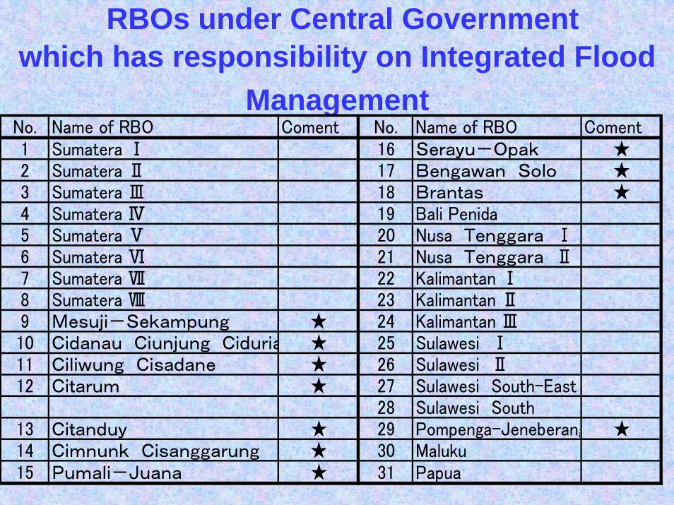
RBOs under Central Governmentwhich has responsibility on Integrated Flood
ManagementNo. Name of RBO Coment No. Name of RBO Coment1 Sumatera Ⅰ 16 Serayu-Opak ★2 Sumatera Ⅱ 17 Bengawan Solo ★3 Sumatera Ⅲ 18 Brantas ★4 Sumatera Ⅳ 19 Bali Penida5 Sumatera Ⅴ 20 Nusa Tenggara Ⅰ6 Sumatera Ⅵ 21 Nusa Tenggara Ⅱ7 Sumatera Ⅶ 22 Kalimantan Ⅰ8 Sumatera Ⅷ 23 Kalimantan Ⅱ9 Mesuji-Sekampung ★ 24 Kalimantan Ⅲ10 Cidanau Ciunjung Ciduria ★ 25 Sulawesi Ⅰ11 Ciliwung Cisadane ★ 26 Sulawesi Ⅱ12 Citarum ★ 27 Sulawesi South-East
28 Sulawesi South13 Citanduy ★ 29 Pompenga-Jeneberang ★14 Cimnunk Cisanggarung ★ 30 Maluku15 Pumali-Juana ★ 31 Papua

Cause of flooding in Jabodetabek
• External: by inundation from the macro drainage, caused by heavy precipitation in the upstream areas.
• Internal: by inundation from the micro drainage system as well.
• Tidal: by inundation from high tidal levels
• A combination of events is worse.
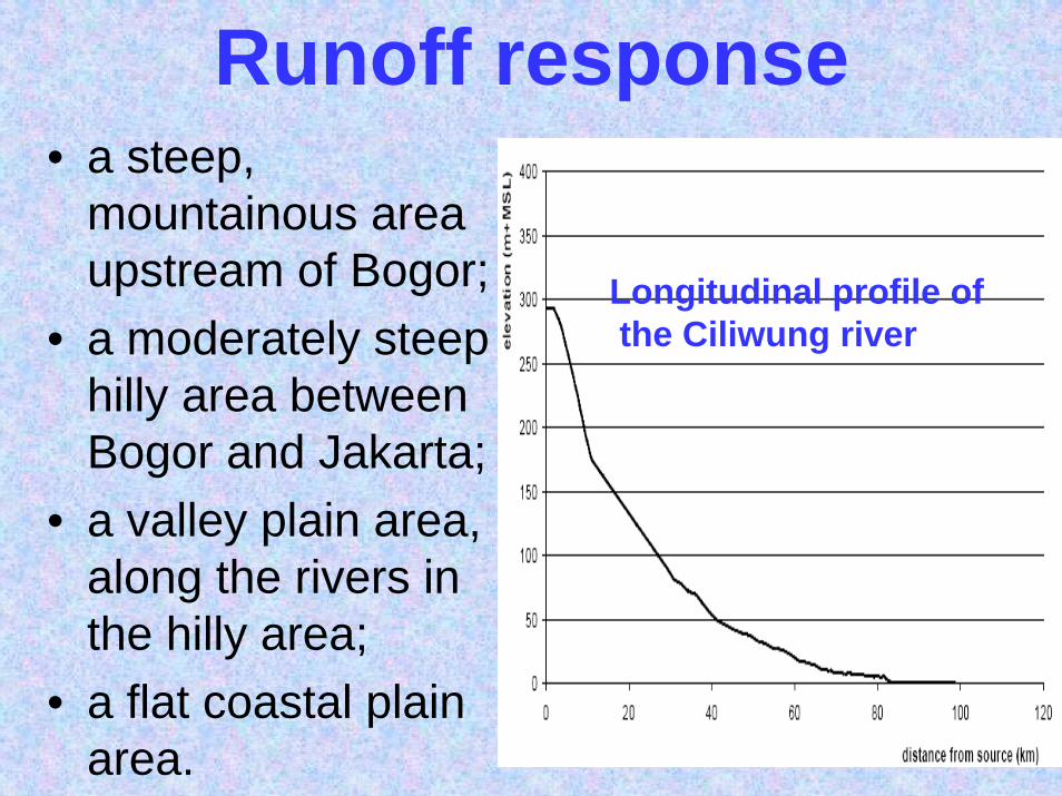
Runoff response• a steep,
mountainous area upstream of Bogor;
• a moderately steep hilly area between Bogor and Jakarta;
• a valley plain area, along the rivers in the hilly area;
• a flat coastal plain area.
Longitudinal profile ofthe Ciliwung river

The rivers that flow through Jakarta quickly respond to rainfall for several reasons:
• The rain falls with high intensities become available for runoff without infiltration;
• A large percentage of the area is urbanised, which causes low infiltration percentages and high (overland) flow velocities;
• The area upstream of Bogor is very steep, leading to high flow velocities.
• the water does not have to travel long distances.

Some major historic floodsYear Affect1699 Ciliwung river floods old Batavia after Mount Salak erupts1714 Ciliwung river overflows after clearing forest areas in Puncak.1854 new Batavia is a meter under water, caused by the raging Ciliwung.
1918 Extensive flooding. The Dutch colonial government begins work on the Western Flood Canal (West Banjir Canal).
1942 The West Banjir Canal is completed, but Jakarta still floods.1996 A flood sweeps through the capital. Approximately 10 people die.2002 The Dartmouth Flood Observatory notes it as the largest flood in
Jakarta’s history, 25 people died.2007 The greatest flood to fit Jakarta in the last three centuries
source: WHO, 2007

Characteristics of the flood events of 1996, 2002 and 2007.
No Flood Event Date Area (ha) Main Origin1 1996 Jan-06 3000 U/S+D/S2 Feb-11 5000 Jakarta3 2002 Jan-31 3000 U/S+D/S4 Feb-03 10000 U/S+D/S5 2007 Feb 20000 DKI

Rainfall on Feb.2, 2007 Rainfall on Feb.4, 2007
RAINFALL CHARACTERISTICSource: Partners for Water, 2007

Urbanisation will give affect to the flood
Urban development in 2000 Urban development in 2025
Source: Partners for Water, 2009

Flood Hazard Map ModelingRR: Rainfall-Runoff Hydrologic Model1D = 1 Dimension Hydraulic Model2D = 2 Dimension Hydraulic Model with Digital elevation Model
Data Requirement•The short duration Rainfall data from Automatic Rainfall Recorder•The flood hydrograph from Automatic Water level Recorder•Longitudinal & CrossSection of the rivers•Topographic map in GIS

Flood Hazard Map
the ‘Communicationstrategies on flood management’
Flood risk maps Flood Evacuatian Map Flood Preparedness Map
Flood Control Measure Community participation in Flood Reduction

Land subsidence Jakarta (2007-2008)
•Lack of rainfall & •Discharge Data•Land Subsidence
The Challenges of Flood Hazard Map Modeling

Thiessen polygon based on existing rainfall monitoring network
23 rainfall 1,406 km2.the average area covered by one station amounts 61 km2,
Required temporal and spatial resolution for urban drainage simulation (after Berne 2004)Source: Partners for Water, 2009

Subsidence combined with tidal cycles
Source: Partners for Water, 2009

- -0.05
-0.05
-
0.15
Rho Spearman Coefficient Trend
+1 pos trend-1 neg trend0 no trend
There is no indicationOf any positif trend ofannual maximum daily rainfall

Calibration of the Flood Inundation Model based on
• Pubic Works Department Report • Inundation Map From DKI• Field Information• PLN (the electricity company of
Indonesia) data : In case of a flood, PLN will switch off these gardu’s

Flood extent map 2007 based on information of DKI districts and the DEM.Source: Partners for Water, 2009

Katulampa
Panus Depok
Manggarai
Overview of existing automatic water level monitoring networks operated by Balai Besar andPP-DKI
Reach Distance (km) Travel time (hrs)Katu Lampa – Depok 41 3 - 4Depok – MT Haryono 40 8MT Haryono - Manggarai 1,8 2
Source: Partners for Water, 2009

FLOOD HAZARD MAP
Structural measureIncrease the capacity of the river
Source: Partners for Water, 2009

Projected threats(red and orange) of sea levelfrom subsidence in year 2025
Source: Partners for Water, 2009

Overview of proposed automatic water level
monitoring network for Flood Early Warning in
Jakarta for updating the rainfall-runoff
models
The Real Time Data is neededfor Flood Early Warning
Source: Partners for Water, 2009

Summary• Flood occurs in many rivers in Indonesia which
need Flood Hazard Map and Flood Forecasting and Early Warning System such as IFAS as a foundation of flood management
• Because lack of real time hydro meteorological data for flood forecasting and early warning system, its need satellite data to support this.
• We need collaboration with JAXA for flood disaster mitigation in the future

• Sea water levels were not significantly high during the 1996, 2002 and 2007 flood events and therefore did not contribute to the flood extent.
• There is no indication of positive trend of rainfall• Due to subsidence the Jakarta sea defence is
at very critical levels. Flooding from the sea must be taken seriously in the future
• FFEWS : the Automatic Water Level and Rainfall Recorder is needed to be added in the flood monitoring network in Jakarta
Summary

Flood in Menado, 2006