Research and Archaeology: a Framework for the Eastern ... · Research and Archaeology: a Framework...
80
Research and Archaeology: a Framework for the Eastern Counties, 2. research agenda and strategy edited by Nigel Brown and Jenny Glazebrook East Anglian Archaeology Occasional Paper No.8, 2000 Scole Archaeological Committee
Transcript of Research and Archaeology: a Framework for the Eastern ... · Research and Archaeology: a Framework...

Research and Archaeology: a Framework for the Eastern Counties, 2. research agenda and strategy
edited by Nigel Brown and Jenny Glazebrook
East Anglian Archaeology Occasional Paper No.8, 2000
Scole Archaeological Committee

EAST ANGLIAN ARCHAEOLOGY OCCASIONAL PAPER NO.8
Published by The Scole Archaeological Committee for East Anglia Castle Museum Norwich NR1 3JU
Editor: Nigel Brown Managing Editor: Jenny Glazebrook
Scole Editorial Sub-committee: Brian Ayers, Archaeology and Environment Officer, Norfolk Museums Service David Buckley, County Archaeologist, Essex Planning Department Keith Wade, Archaeological Service Manager, Suffolk County Council Peter Wade-Martins Stanley West
Set in Times Roman by Joan Daniells and Jenny Glazebrook using Corel Ventura Printed by Witley Press Ltd., Hunstanton, Norfolk
© The Scole Archaeological Committee
ISBN 0 9521848 2 6
For details of other titles in this series, see back cover
This report is published with the aid of a grant from English Heritage
Cover illustration Iron Age settlement at Wardy Hill, Cambridgeshire © Ben Robinson and Cambridgeshire County Council Archaeological Field Unit

Contents
Contents v List of Plates vi Contributors vi Acknowledgements vi Summary vii
Introduction, by Nigel Brown and Keith Wade I. Background 1 II. Purpose of the Agenda and Strategy 1 Bibliography 2
Agenda
Palaeolithic and Mesolithic, by Louise Austin I. Lower and Middle Palaeolithic 5 II. Broad topics 5 III. Geographical areas 6 IV. Projects 6 V. Upper Palaeolithic and Mesolithic 6 VI. Broad topics 7 VII. Projects 7 Bibliography 8
Neolithic and Bronze Age, by Nigel Brown and Peter Murphy I. Introduction 9 II. Gaps in knowledge 9 III. Potential of resource 10 IV. Research topics 10 Bibliography 12
The Iron Age, by Stewart Bryant I. Introduction 14 II. Gaps in knowledge 14 III. Potential of resource 15 IV. Research topics 16 V. Project 17 Bibliography 18
Roman, by Chris Going and Jude Plouviez I. Introduction 19 II. Gaps in knowledge 19 III. Potential of resource 20 IV. Research topics 21 Bibliography 22
Anglo-Saxon and Medieval (Rural), by Keith Wade I. Introduction 23 II. Gaps in knowledge 23 III. Potential of resource 25 IV. Research topics 25 Bibliography 26
Anglo-Saxon, Medieval and Post-Medieval (Urban), by Brian Ayers I. Introduction 27 II. Gaps in knowledge 27 III. Potential of resource 28 IV. Research topics 29 Bibliography 32
Post-Medieval and Modern, by Paul Gilman, Shane Gould and Sarah Green I. Introduction 33 II. Fortifications, by Paul Gilman 33
Introduction 33 Gaps in knowledge 33 Potential of resource 34 Research topics 36
III. Parks and Gardens 1540–1960, by Sarah Green 36 Introduction 36 Gaps in knowledge 36 Potential of resource 37 Research topics 38
IV. The Archaeology of Industrialisation and Manufacture 1750–1960, by Shane Gould 39 Introduction 39 Gaps and potential 40 Research topics 40
Bibliography 42
Research Themes, by Nigel Brown, Peter Murphy, Brian Ayers, Stewart Bryant and Tim Malim I. Introduction 44 II. Origins and development of the Agrarian
Economy 44 III. Urban development 45 IV. Finds studies 45 V. Human remains 46 VI. Selective survey 46 VII. Political and social development within
territories 47 Bibliography 48
Strategy
Research Strategy, by Keith Wade and Nigel Brown I. Introduction 50 II. Current initiatives 51 III. Selecting priorities for research 51 IV. Management research 52 V. Threat-led research 53 VI. Pro-active research 54 VII. Review 54 VIII. Funding 54 IX. Future action 55 Bibliography 58
Appendix: Current Initiatives 59 Index, by Sue Vaughan 71
v
List of Plates
Plate I Plate II
Blakeney esker, Norfolk Ardleigh style pottery from White Colne,
8 Plate VII Excavation on the Millennium Library site, Norwich 30
Essex 11 Plate VIII Martello tower, Walton-on-Naze, Essex 35 Plate III Plate IV
Stonea Camp near March, Cambridgeshire Burgh Castle, Norfolk
15 20
Plate IX Leicester Square Farm, South Creake, Norfolk 38
Plate V ‘Bed burial’ from Barrington, Plate X Southend Municipal Hospital,
Plate VI Cambridgeshire Late Anglo-Saxon landscape at Hinxton
24 Plate XI
Rochford, Essex Multi-period cropmarks at Orsett, Essex
41 56
Hall, Cambridgeshire 26
Contributors
Louise Austin, formerly Libraries and Heritage, Cambridgeshire County Council
Brian Ayers, Archaeology and Environment Officer, Norfolk Museums Service
Nigel Brown, Heritage Conservation, Essex County Council
Stewart Bryant, County Archaeologist, Hertfordshire County Council
Paul Gilman, Heritage Conservation, Essex County Council
Jenny Glazebrook, Managing Editor, East Anglian Archaeology
Chris Going, Archaeological Consultant
Sarah Green, Countryside Section, Essex County Council
Shane Gould, Heritage Conservation, Essex County Council
Tim Malim Archaeological Field Unit, Cambridgeshire County Council
Peter Murphy, English Heritage Regional Advisor for Archaeological Science, Centre of East Anglian Studies, University of East Anglia
Jude Plouviez Conservation Team, Suffolk County Council
Keith Wade, Archaeological Service Manager, Suffolk County Council
Acknowledgements
The main co-ordinators in this exercise have been the County Archaeologists from the five counties, namely Stewart Bryant (Herts), David Buckley (Essex), Simon Kaner (Cambs), Keith Wade (Suffolk) and Peter Wade-Martins and Brian Ayers (Norfolk). They have received much input from appropriate members of their staff, in particular Nigel Brown and Caroline Ingle (Essex). Caroline Ingle has also acted as secretary to the co-ordinating Committee. The various chapters were prepared and edited by archaeological specialists in the region comprising Louise Austin, Nigel Brown, Stewart Bryant, Chris Going, Jude Plouviez, Keith Wade, Brian
Ayers, Paul Gilman, Shane Gould and Sarah Green. The archaeological science input was provided by Peter Murphy, who is most grateful to Umberto Albarella, Charly French and Patricia Wiltshire for their comments on an earlier draft. Valuable contributions and comment were received from Richard Bradley, Martin Carver, Mike Fulford and Francis Pryor; Adrian Olivier, Philip Walker, Deborah Priddy (English Heritage); Peter Topping (RCHME), and Jenny Glazebrook (EAA managing editor). Beyond this many people have been involved in the consultation exercise (see appendixto Part 1). Thanks are given to them all for their time and input of their specialist knowledge.
vi

Summary
This regional research framework provides an overview of the archaeological resource in the five eastern counties of Essex, Suffolk, Norfolk, Cambridgeshire and Hertfordshire, and highlights key research issues. The framework is one of a number currently being prepared for various regions in England.
November 1990 saw the publication of Planning Policy Guidance Note 16: Archaeology and Planning (PPG16), and this marked a clear turning point in the organisation of archaeology in England. Previously archaeology had been peripheral to the planning process; the new guidance fundamentally altered this, and archaeological concerns are now an integral part of the planning system, administered by local authority archaeologists advised and assisted by English Heritage. Archaeological work arising from the planning process is now funded by developers and carried out by archaeological contractors operating on a commercial basis. These new patterns of working were augmented by the publication, in 1994, of Planning Policy Guidance Note 15: Planning and the Historic Environment (PPG15).
The implementation of these new planning procedures generated a sharp increase in archaeological fieldwork. Increasingly, however, a number of individuals and organisations expressed concerns that much of the work lacked a coherent research focus. In response to these concerns a wide-ranging consultative process carried out within the archaeological discipline led to the publication by English Heritage of Frameworks for Our Past (Olivier 1996), a document which set out the need for regional research frameworks.
Local authority archaeologists within the five eastern counties have a long established regional co-ordination group, and this has facilitated the preparation of a research framework for the eastern counties. The format of the framework was suggested by the tripartite structure set out in Frameworks for Our Past and comprises:
Resource assessment: the current state of knowledge and understanding. Research agenda: gaps in knowledge, potential of resource, research topics. Research strategy: priorities and methods for implementing the agenda.
The framework adopts a chronological format, and is published in two parts. Part 1 comprised the resource assessment and was published in 1997 as Research and Archaeology: a Framework for the Eastern Counties 1. resource assessment (East Anglian Archaeology Occasional Paper 3). This volume Research and
Archaeology: a Framework for the Eastern Counties 2. research agenda and strategy (East Anglian Archaeology Occasional Paper 8), represents Part 2 of the framework. A full description of the processes by which the framework was produced is provided in the introduction to Part 1 and summarised in the introduction to Part 2. Each volume can be used independently, but together they form a single framework and are best regarded as a whole.
The Resource Assessment comprises an introduction and seven period-based chapters dealing with Palaeolithic and Mesolithic; Neolithic and Bronze Age; Iron Age; Roman; Anglo- Saxon and Medieval Rural; Anglo-Saxon, Medieval and Post-Medieval Urban; Post-Medieval and Later. These papers provide succinct summaries of the evidence available for the region. Each chapter is provided with an extensive bibliography, which enables the reader to access the wider literature. The period divisions in part reflect the expertise available within the region. The split between rural and urban in the post-Roman chapters is purely a matter of convenience in dealing with the large body of data available for these periods. It is recognised that future studies will need to explore the interdependence of towns and the countryside. Similarly the post-medieval and later chapter does not provide a complete account of the complex archaeological data for the recent past; rather it consists of three linked essays on fortifications, industrial archaeology and parks and gardens.
The Research Agenda follows the same format as the resource assessment with seven period-based chapters which set out something of the potential of the evidence currently available within the region, together with gaps in knowledge and research topics. In addition to the period contributions, a thematic chapter includes a range of research issues which could usefully be addressed within the region and which cut across one or more of the period divisions. The final chapter comprises a Research Strategy which considers priorities for future research and outlines an integrated approach to research within the region, exploring collaborative arrangements and partnerships.
This research framework for the eastern counties will provide a firm foundation for archaeological work within the region, both in generating high quality research and in ensuring that the full potential of the results of PPG15 and PPG16 investigations is developed. Synthesis and interpretation are seen as central to this purpose. However, research is a dynamic process and it is recognised that the present framework is very much a statement at a particular point in time, and will require periodic review, amendment and updating.
vii

‘Every body does not see alike. To the Eyes of a Miser a Guinea is more beautiful than the Sun, and a bag worn with the use of Money has more beautiful proportions than a Vine filled with Grapes. The tree which moves some to tears of joy is in the Eyes of others only a Green thing that stands in the way’.
William Blake (letter to Dr Trusler 23 August 1799)
viii

Introduction by Nigel Brown and Keith Wade
What we need to do now is to devote substantial effort and resources both financial and intellectual over an extended period — maybe a decade or more — to taking stock of and consolidating what we have learnt, and to identifying and carrying out wider projects of analysis and synthesis in order to extend our knowledge of the archaeological record and our understanding of the past. (Thomas 1994)
It is always too soon to synthesise, but it is always imperative to do so. (Bradley 1996)
I. Background
The present document, a Research Agenda and Strategy, represents part 2 of a Research Framework for the Eastern Counties. Part 1, the Resource Assessment, described the reasoning behind the creation of such a framework, the area covered and the methodology employed (Buckley 1997). However it may be helpful to reiterate a few of the main points here.
The region was defined as the area served by the administrative counties of Cambridgeshire, Norfolk, Suffolk, Essex and Hertfordshire, with boundaries as at the end of 1995. These five counties have had an established regional co-ordination group for many years (Buckley 1997), and this long-standing history of co-operation between local authority archaeologists of the region has provided the impetus and mechanism for preparation of this framework. The co-ordination group has recently been extended to include Bedfordshire and is now coincident with the Regional Development Agency. The present research framework could not be extended to include that county without considerable reworking. However, Bedfordshire is currently preparing a county-based research framework which will complement the eastern counties one, and it is anticipated that any future revision will include Bedfordshire.
The format of the regional research framework follows that proposed by Thomas (1994) as subsequently modified in Frameworks for our Past (Olivier 1996, 5) and reiterated in the MARS report (Darvill and Fulton 1998, 231). This format was summarised in the Resource Assessment (Buckley 1997, 2) as follows.
A research framework comprises:
Resource assessment: the current state of knowledge and understanding.
Research agenda: gaps in knowledge, potential of resource, research topics.
Research strategy: priorities and methods for implementing the agenda.
A further stage beyond the scope of the present document can be defined as:
Research project: a detailed proposal to further the research strategy.
The period format adopted for the resource assessment has been largely retained for the research agenda, with the addition of a thematic chapter which highlights some areas of research which cut across period divisions.
The procedure followed in the preparation of this document was broadly similar to that adopted for the Resource Assessment (Buckley 1997, 2).
A draft text was prepared largely by those responsible for drafting the various chapters of the resource assessment, under the auspices of a steering committee made up of local authority archaeologists within the region, and English Heritage.
Following discussion and amendment within the steering committee, the draft document was circulated to a wide range of individuals for comment. The text was then revised in the light of comment received and further discussion within the committee.
The consultation process was repeated and in addition comments were sought from three paid readers. The document was once again revised and then this volume was produced.
The considerable costs of preparing this framework were largely borne by the five county councils; English Heritage grants assisted with the consultation stages, and with publication.
A research framework for the Greater Thames Estuary has recently been prepared by Essex and Kent County Councils, English Heritage, and RCHME (Williams and Brown 1999). The area covered by this document substantially overlaps that dealt with by the eastern counties framework. The two frameworks complement one another and should allow similarities and contrasts to be explored across a wide area of eastern England (Cunliffe 1982, 40; Bradley 1993, 56). A research framework is also being prepared for the East Midlands. For Greater London English Heritage have published Capital Archaeology: Strategies for sustaining the historic legacy of a world city (English Heritage 1998), a resource assessment is provided by Archaeology of Greater London (MOLAS 2000) and a research agenda is in preparation. These developments will provide a firm foundation for archaeology in eastern England in the 21st century. In addition the area covered by the eastern counties framework forms an integral part of a European region centred on the North Sea basin. Research generated by this framework should be viewed within this European context.
II. Purpose of the agenda and strategy
Research/explanation and management/conservation are currently the two main concerns of the archaeological discipline. Whilst attempts have been made to reconcile these two aims (Carver 1996), they are often seen to be in conflict, and the former has received vocal and erudite championship as the prime aim of archaeology (e.g.
1

Barrett 1995; Biddle 1994). Although potential or actual tensions may arise between these areas of activity, it seems best to regard these two broad aims as ‘...overlapping and reinforcing roles...’ (Renfrew 1996), mutually supporting rather than necessarily conflicting. However, given the complementary role of research/explanation and management/conservation just espoused, and the nature of the committee (Buckley 1997) which has taken the lead role in the creation of this regional framework, awareness of management/conservation concerns underlie the research agenda presented here.
Research is seen as central both to the implementation of PPG16 (Thomas 1994; Courtney 1996, 107; Reeve 1997; Wade-Martins 1996, 39) and to the MAP 2 process (Andrews and Thomas 1995, 204). As such, the necessity of providing an adequate research framework, against which ‘...the thousands of individual research designs that are required by the implementation of PPG16...’ (Pryor 1995, 230) can be judged, is widely recognised (e.g. Wainwright 1996, 6; Olivier 1996, 223; English Heritage forthcoming). This research framework is intended both to provide a context for the development of coherent research projects and to support and inform work arising from the implementation of PPGs 15 and 16.
The Resource Assessment (Glazebrook ed. 1997) indicates the scale and range of the archaeological data currently available. There are clearly gaps in our knowledge and certain of these are highlighted in the period accounts presented below. Part of the research agenda may simply be directed at filling these gaps. Despite the wealth of information available in the region and presented in the resource assessment, it is perhaps worth noting that even now certain baseline information may be lacking.
Research excavation has tended (as did rescue work during the 1970s and 1980s) to concentrate on the same sort of sites (prolific in artefacts, large, obvious above-ground evidence, etc.). However, the need for some understanding of the full range of settlement is increasingly urgent as it is being constantly eroded, by development, ploughing and afforestation. Although this erosion has been recognised for some fifty years, there has not been a holistic approach to quantifying it or dealing with it. The Monuments at Risk Survey (MARS, Darvill and Fulton 1998), Monuments Protection Programme (MPP) and related initiatives have improved understanding and protection of the resource base. Agricultural erosion of the archaeological resource has tended to be ignored in comparison with rescue excavation linked to development. However, the establishment of adequate mechanisms to deal with development threats is the outstanding success story of the last twenty years culminating in PPGs 16 and 15. In terms of land use, however, development will only affect a small percentage of land. Whereas, within the region, for instance in a county like Suffolk, ploughing affects 66% of the land area and hence, most of its sites. In fact, afforestation could
affect more sites than development if the Rural White Paper’s target of doubling woodland in the next 50 years is achieved (Rural England — A Nation Committed to a Living Countryside, 1995). The extent to which the resource is being eroded should be better understood when the results of MARS are fully assimilated, and it is notable that the MARS report identifies agriculture as the largest
single threat to the archaeological resource (Darvill and Fulton 1998, 236–7).
Archaeology, as a discipline, can learn much from the natural sciences. Although Carver’s (1996, 47–50) strictures against the wholesale application of ecological principles to archaeology should be kept clearly in mind, the concept of biodiversity, in relation to natural resources, might be transferable to archaeology resources (‘Archaeodiversity’). If we are to preserve the diversity of the archaeological resource for future generations then we must concentrate on expanding our knowledge of the resource base as our contribution to Local Agenda 21 initiatives.
Nonetheless the regional research agenda cannot simply rely on filling gaps in knowledge. The two quotations at the start of this chapter were chosen with a purpose, that from Thomas follows on from a description of the previous couple of decades as a period of orgiastic data collection. The traditional metaphor of archaeology as an incomplete jigsaw puzzle — find a few more pieces and the picture will be clearer — is not entirely helpful. The truth is not out there, simply waiting to be discovered by more fieldwork. Research should be as much, perhaps more, concerned with interpretation and synthesis of existing data, as with new data collection (Reeve 1997). Further fieldwork will undoubtedly be required; however, the museum collections, published reports, excavation archives, results of evaluations, and sites and monument records of the region are a resource of inestimable value. The agenda set out below is wide-ranging, yet it cannot be all-embracing, neither is it intended to be an exclusive and static list.
The challenge for this regional research framework is to facilitate programmes of work which utilise this resource, in combination with fieldwork, to enhance our understanding of the region’s archaeology. It is intended that this will be pursued both at an academic level and through programmes of public information and education. Encouragement of popular appreciation of the region’s archaeology and enhanced understanding of its educational and tourism potential (Jones 1997) should be key aims of research. To summarise, we would endorse the three key concepts for ‘Advancing Understanding of England’s Archaeology’ set out in the draft English Heritage research agenda (English Heritage forthcoming, 16): synthesis, targeted data collection, accessibility of information, and these principles should underpin research initiatives arising from this framework.
Bibliography
Andrews, G. and Thomas, R., 1995
‘The management of archaeological projects: theory and practice in the UK’, in Cooper, M., Firth, A., Carmen J., Wheatley D., Managing Archaeology, 189–207
Barrett, J.C., 1995 Some Challenges in Contemporary Archaeology, Archaeology in Britain Conference 1995/Oxbow Lecture 2
Biddle, M., 1994 What Future for Brit ish Archaeology? , Archaeology in Britain Conference 1994/Oxbow Lecture 1
Bradley, R., 1993 ‘Where is East Anglia? Themes in Regional Prehistory’, in Gardiner, J. (ed.), Flatlands and Wetlands: Current themes in East Anglian Archaeology, E. Anglian Archaeol. 50, 5–13
2

Bradley, R., 1996 ‘Rethinking the Later Bronze Age’, in Bedwin, O. (ed.), The Archaeology of Essex: Proceedings of the 1993 Writtle Conference, 38–45
Buckley, D.G., 1997
‘Introduction’, in Glazebrook, J. (ed.), Research and Archaeology: a Framework for the Eastern Counties 1. resource assessment, E. Anglian Archaeol. Occ. Pap.3
Carver, M., 1996 ‘On Archaeological Value’, Antiquity 70(267), 45–56
Courtney, P., 1996 ‘Review of Gwent Levels: The evolution of a Wetland Landscape by Rippon, S.’, Landscape History 18, 106–7
Cunliffe, B., 1982 ‘Social and economic development in Kent in the pre-Roman Iron Age’, in Leach, P. (ed.), Archaeology in Kent to AD 1500, Counc. Brit. Archaeol. Res. Rep. 48, 40–50
Darvill. T. and Fulton, A., 1998
The Monuments at Risk Survey of England 1995: Main Report
English Heritage, forthcoming
Exploring our Past 1998
English Heritage, 1998
Capital archaeology: Strategies for sustaining the historic legacy of a world city
Glazebrook, J. (ed.), 1997
Research and Archaeology: a Framework for the Eastern Counties 1. resource assessment, E. Anglian Archaeol. Occ. Pap.3
Jones, M., 1997 ‘Message from the Chairman’, Science-based Archaeology Newsletter 11, 1–2
Museum of London Archaeology Service, 2000
Archaeology of Greater London
Olivier, A., 1996 Frameworks for our Past, (English Heritage)
Pryor, F., 1995 ‘Management objectives: context or chaos?’, in Cooper, M., Firth, A., Carmen, J. and Wheatley, D., Managing Archaeology, 224–233
Reeve, J., 1997 ‘From the Chair’, The Archaeologist 28, 2
Renfrew, C., 1996 ‘Forward’, in Croft, R.A. and Tindall, A.S. (eds), Archaeology and the Historic Environment 1
Thomas, R., 1994 ‘Where Next?’, (unpublished paper presented at the IFA Annual Conference 1994, Bradford)
Wade-Martins, P., 1996
‘Looking Back and Looking Forward’, in Croft, R.A. and Tindall, A.S. (eds), Archaeology and the Historic Environment 37–40
Wainwright, G., 1996
‘Managing England’s Archaeological Heritage’, in Croft , R.A. and Tindall , A.S. (eds), Archaeology and the Historic Environment 4–7
Williams, J. and Brown, N., 1999
An Archaeological Research Framework for the Greater Thames Estuary, (Essex County Council)
3

Agenda
4

Palaeolithic and Mesolithic by Louise Austin
I. Lower and Middle Palaeolithic
The recently published Research Framework (Prehistoric Society 1999) has set national parameters for the Palaeolithic and Mesolithic of Britain.
The Resource Assessment has identified both the importance of East Anglia’s Pleistocene deposits and the paucity of recently excavated in situ sites (Austin 1997). Any opportunity to investigate and study further in situ remains will undoubtedly provide information of national importance. Most aspects of the period could be described as poorly understood at present, even though East Anglia has provided some of the best information from Britain.
The research themes which come out of any document such as this will undoubtedly address the burning questions of today but cannot hope to second-guess what future generations will wish to know of their past. Research in this period has in recent years benefited from renewed interest, resulting particularly from advances in scientific techniques and methodologies borrowed from other disciplines. This has resulted in the archaeological community at large recognising and appreciating the potential the remains from this period have to push back the bounds of our understanding of human development and its relationship with the developing landscape.
There is a need for a flexible framework which is not exclusive and allows new information and interests to be accommodated. It is recognised that any research agenda must be evolving and not fixed. Previously published articles have raised questions on archaeological research into the Palaeolithic and these were referred to in the preparation of this section (Andresen et al. 1996; Isaac 1972; Potts 1994; Gowlett in press). Wymer (1999) provides a national overview and discussion of the current evidence.
The construction of a tiered set of research aims and objectives for this period is therefore thought most appropriate. Layers of questions, answerable at differing levels, linking the broad questions of national and international significance with the more specific local questions was considered necessary. This agenda comprises two parts, the first includes a number of broad research topics while the second looks at specific geographical areas across the region.
At all levels these research questions also need to include methodologies to survey and evaluate the archaeological potential of Pleistocene deposits, formulating predictive models and scales of importance as well as a planned response to identified threats.
The most important first stage is more detailed survey of the surviving Pleistocene deposits in East Anglia. An audit of the present resource would produce a baseline data set which could form the basis for more specific project proposals to be drawn up.
II. Broad topics
Survey: quantification and qualification of the resource Detailed survey following on from the successful results of The English Rivers Palaeolithic Survey (Wessex Archaeology 1995–1996) is required to adequately understand the Pleistocene archaeological resource which survives in East Anglia and needs to include an assessment of its environmental potential.
The research potential of different types of Pleistocene deposit needs to be investigated and mapped e.g. good survival of environmental remains in buried soils and fine grained channel-edge sediments, or high energy deposited outwash gravels containing redeposited artefacts. More understanding of past and present impacts on the surviving resource is needed and the types of threats which are currently affecting the remaining deposits. Identification, exploration and assessment of new ways to mitigate these threats are also required.
Due to the nature and location of the ‘natural’deposits which contain this Pleistocene archaeological material, the usual methodological approaches to evaluation and excavation have been shown to be problematic. New methodologies need to be developed and tested to allow the economic evaluation of such sites in order to understand their potential and enable deposit modelling and predictive landscape models to be developed.
Chronology Of fundamental importance to understanding the period is the chronological framework. This is still poorly understood for many sequences across the region. The potential for broadening chronological understanding through linking such sequences needs to be explored both within the region and at national and international levels.
Landscape As with many other periods, the importance of studying the archaeology of the period within its landscape context is now more fully realised. Various sub-themes can be drawn out within this heading such as environmental reconstruction, transportation dynamics, on site/off site recognition among many.
Hominid behaviour The potential is present for in situ remains such as working floors, kill sites, hearths, shelters etc. to provide as yet unparalleled information on the culture and behaviour of individuals and groups. However there is also much to be understood from less well-preserved evidence of hominid activity and its relationship to the surrounding landscape.
Economy Almost nothing is known about the economies of hunter-gatherers in the region. Retrieval of biological remains from in situ Palaeolithic and Mesolithic sites is a very high priority. For the Palaeolithic, the results of the English
5

Rivers Project (Wymer 1996; 1997 and 1999) will document where such sites may be found; for the Mesolithic, buried surface-intact sites are known in the Fens, in the Lea Valley and elsewhere. Project briefs and specifications for archaeological interventions at any buried site of these periods must include a substantial ‘environmental’ component. Extensive sampling is required.
III. Geographical areas
Each of the following identified areas has high potential for survival of Palaeolithic archaeological remains. The questions which can and are currently being asked of the archaeological material from each of these areas are numerous and only a brief few are noted here. This list is by no means exhaustive and is intended to just give an indication of the types of questions which a particular area might answer. All of the broad themes can also be addressed in all of these areas and in others which have yet to be identified.
Chiltern Brickearths There is at present a lack of environmental and dating evidence which has been studied although it is believed that there are suitable remnants of the deposits to allow this work to be carried out (M. White pers. comm.). Survey is initially required to identify suitable deposits, also the development of new methodologies to provide sufficient information.
Thames — including the current course as well as palaeo-channels Further investigation of the pre-Anglian channels of the Thames should be undertaken which will allow more detailed assessment of the presence of archaeology in these deposits (Bridgland 1994). Further investigation of the dating of the present Thames terrace deposits is needed. The results of such investigations can also feed into the further work required to link the terrace sequence into the surrounding landscape. There is also potential for linking such a sequence with the Lowestoft till deposits.
Ingham/Bytham River These pre-Anglian deposits include sites which have proved to be prolific such as Warren Hill (Wymer 1985) and well-preserved such as High Lodge (Ashton et al. 1992). The full sequence of the river’s deposits need to be identified and studies carried out to assess the potential for archaeology in the whole of the sequence. There is also potential to identify a linking point in the pre-Anglian river systems.
Post-Anglian lacustrine deposits These include stage 11 lake deposits such as those identified at Hoxne (Wymer 1983). Survey work is required to identify other similar surviving pockets. The presence and interpretation of these deposits needs to be linked to an understanding of the broader landscape. The possibility of a tiered approach to understanding the environment may help to build a better picture of this landscape.
North Norfolk coast The area has had little previous study. However it has been recognised that the Pleistocene deposits have a high potential for archaeological and environmental information, with the possibility of evidence for a stage 10 glaciation (N. Aston pers. comm.). At present there is little archaeological information from this area.
Ouse and Cam valleys Recent work (see Reynolds forthcoming) has challenged the accepted chronology of these terrace sequences. Recent evidence recovered from gravel extraction suggests that these deposits are far richer than antiquarian collection had suggested. Further investigation and identification of in situ remains and the recovery of good dating evidence is needed.
Other river valleys Other valleys where there has been no systematic, or in some cases any, concerted study currently lack enough information for their archaeological potential to be assessed. This lack of consistent evidence needs to be addressed. Many other river valley terrace deposits are likely to contain comparative material.
Linking of these areas More exploration of the archaeological, stratigraphic and sequential links between these specific areas is also needed.
IV. Projects
Specific projects will need to be formulated to address these and other specific questions concerning these areas of interest within the region. The projects should always be explicit in the way the results of the work will feed into the broader questions and themes directly adding to the larger picture.
Work also needs to be done to ensure that Pleistocene archaeology is viewed as part of mainstream archaeology and not as a separate discipline, and that it is properly integrated into the archaeological aspects of the development control process. This can perhaps be most easily achieved by ensuring that all appropriate landscape or site assessments and studies incorporate an assessment of the Pleistocene deposits by a suitably qualified specialist.
Research is required which will enable detailed recording strategies to be formulated for particular types of site in order to provide advice and guidance to planning archaeologists.
Research strategies need to be developed to enable the study of Palaeolithic archaeology to be more strategic and proactive in its approach rather than the present situation which is ad hoc and reactive.
V. Upper Palaeolithic and Mesolithic
The particular research questions for this period perhaps relate more easily to the general themes which have been picked up elsewhere in the regional agenda, as well as nationally by English Heritage, than those for the Lower and Middle Palaeolithic.
Although the region includes areas where there is an identified high potential for the survival of well preserved
6

Upper Palaeolithic and Mesolithic sites, for example the fen/fen edge, there is a scarcity of known occupation sites, in particular recent well excavated examples where there is associated environmental data in good condition.
In order to identify more of these sites, a baseline understanding of the surviving archaeological record is required. Comprehensive survey of the resource is undoubtedly first on the list of priorities. This will confirm the identification of areas of potential as well as allowing the identification of specific sites. Understanding the location, extent, nature, state of preservation and significance of the surviving resource is of fundamental importance as a first step towards addressing the wider research themes.
The areas of research which need to be addressed by future work can be divided into a number of broad themes.
VI. Broad topics
Before any of the themes are addressed, basic quantification and qualification of the resource is required, and this should include survey. Areas which have a high potential for the survival of well preserved Palaeolithic and Mesolithic ground surfaces need to be mapped. Areas need to be identified where for example sealed valley deposits, sealed/waterlogged fen-edge deposits or estuarine deposits have the potential to contain late glacial/post-glacial archaeological remains. Using this information, predictive modelling strategies can then be developed. This information will also inform the planning process and should enable the formulation of management strategies to respond to current threats which include potential dewatering as a result of mineral extraction, drainage and so on.
Landscape Study of the landscape needs to incorporate the environmental context, as well as landscape dynamics. Another aspect which needs to be addressed and investigated is the increasing impact of humans on the environment and the effect of this on its changing use. More palaeo-environmental data needs to be obtained which can be tied in with the archaeological record. With such information, landscape modelling should be accomplished which can feed back into predictive modelling, survey and investigation.
The question of what is a site and what isn’t needs to be explored. What is it that defines a site? On site/off site differentiation needs to be addressed along with the problem of identifying activity areas without buried features and high-density flint debitage. The scale of investigation and the sample size needs to be considered. If the activity takes place across several hectares, looking at one small part of that activity which may discretely cover only tens of square metres will give a very different picture. Site/territory dynamics also need to be explored.
Further aspects of activity which need to be investigated through study of landscape include such matters as the sources of raw materials.
Transitions Investigation of the transition period from the Palaeolithic to Mesolithic is needed. Exploration to identify possible changes, continuities, processes and causes particularly relating to such aspects as the environment and
technology, among others, are required. The Mesolithic to Neolithic transition also requires study, particularly into the processes of change c. 5000–3000 BC.
Human behaviour Even more so than with earlier Palaeolithic evidence there is potential for the survival of well preserved in situ remains such as working floors, kill sites, hearths, shelters etc. particularly in waterlogged contexts. These can provide excellent evidence of individual as well as group behaviour. However, there is also a need to consider the rest of the landscape. There is potential in the study of evidence within previous collections of material which may help to elucidate the relationship of these people to their surrounding landscape.
Interpretation of occupation sites and related ‘scatter’ sites Identification, sampling and excavation of occupation sites, particularly those with associated well preserved organic remains, is needed. This should provide more information on the environment and the economy. Sites with good animal bone assemblages are of particular interest.
VII. Projects
In order to formulate specific rather than broad theme objectives, projects will need to identify baseline information, that is identify the surviving level of resource for the period. Targeted surveys which will identify appropriately dated deposits and their potential for preservation, and survival of important archaeology, are needed. In particular these are necessary as planning tools as well as research tools.
Example — The Thames Northern Tributaries Project The high potential of the Lea Valley for Upper Palaeolithic and Mesolithic remains has been noted in the resource assessment. Investigative work in the Broxbourne area has identified a number of sites. However, the full extent of deposits dating to this period and the potential these have for the survival of important archaeological remains in the Lea and other Thames tributaries is by no means fully understood. Project work which brings together available information, identifying areas where deposits do survive, is therefore considered particularly necessary to inform the development control process both of where deposits survive and the relative importance of those remains.
Concerns have been raised about the threat to the resource in the southern part of the region posed by mineral extraction. The implications of gravel extraction and other forms of development increasing the pressure of urban spread in the tributary river valleys running south into the Thames, result in both direct and indirect impacts on the resource. In particular, gravel extraction has produced a draw-down effect and dewatering of well preserved organic deposits has resulted. The Thames Northern Tributaries Project (Lewis 1995) has been envisaged as a survey to produce a tool for the planning process. As part of the project, a management strategy will be formulated for the surviving remains, which include high archaeological potential. Similar management strategies are required for other high potential areas such as the Fen/Fen edge and Breckland.
7
Plate I An Ice-Age feature known as the Blakeney esker, near the north Norfolk coast. (Photo: D.A.Edwards, 2 March 1986, ref. TG0242/J/AZR27, copyright Norfolk Museums Service)
Bibliography
Andresen, S.A., ‘Approaches to the analysis of evidence from the Bell, D.A., Hallos, Acheulean site of Beeches Pit, Suffolk, England’, J., Pumphrey, T.R.J. Archaeological Sciences 1995, 411–416, (Oxbow and Gowlett, J.A.J., Books) 1996
Austin, L., 1997 ‘Palaeolithic and Mesolithic’, in Glazebrook, J. (ed.), Research and Archaeology: a Framework for the Eastern Counties 1. resource assessment, E. Anglian Archaeol. Occ. Pap. 3, 5–11
Ashton, N.M., High Lodge. Excavations by G. de G. Sieveking Cook, J., Lewis, 1962–68 and J. Cook 1988, (British Museum) S.G., and Rose, J., 1992
Bridgland, D.R., Quaternary of the Lower Thames, (Chapman and 1994 Hall, London)
Glazebrook, J. Research and Archaeology: a Framework for the (ed.), 1997 Eastern Counties 1. resource assessment, E.
Anglian Archaeol. Occ. Pap. 3
Gowlett, J.A.J., in Barton C.M. and Clark G.A. (eds) , (in press) Evolut ionary theory in archaeological
explanation, (Arizona, UPA/AAAS)
Isaac, G.L.I., 1972 ‘Early phases of human behaviour: models in Lower Palaeolithic archaeology’, in Clarke, D.L. (ed.), Models in archaeology, 167–199, (London: Methuen)
Lewis, J., 1995 Thames Northern Tributaries Project Design, (Hertfordshire and Essex County Councils)
Potts, R., 1994 ‘Variables versus models of early Pleistocene hominid land use’, in Oliver, J.S., Sikes, N.E. and Stewart, K.M. (eds), ‘Early hominid Behavioural Ecology’, J. Human Evolution 27, 7–24
Reynolds, T., forthcoming
‘Palaeolithic of the Ouse and Cam Valleys’, in Proceedings of the Archaeology of the Ouse Valley Conference 1994
Wymer, J.J., 1983 ‘The Lower Palaeolithic Sites at Hoxne’, Proc. Suffolk Inst. Archaeol. Hist. 35, 169–89
Wymer, J.J., 1985 Palaeolithic of East Anglia
Wymer, J. J., 1996 The English Rivers Palaeolithic Project, Report 1, The Thames Valley and The Warwickshire Avon, (Wessex Archaeology and English Heritage)
Wymer, J.J., 1997 The English Rivers Palaeolithic Project, Report 3, East Anglian Rivers and the Trent Drainage, (Wessex Archaeology and English Heritage)
Wymer, J.J., 1999 The Lower Palaeolithic Occupation of Britain, (Wessex Archaeology and English Heritage)
8
Neolithic and Bronze Age by Nigel Brown and Peter Murphy
The next stage is to suggest how a prehistory based on the evidence of the lowlands would look different from the schemes that are currently in favour. (Bradley 1992)
I. Introduction
By its very nature in presenting a highly compressed summary of the evidence available for the Neolithic and Bronze Age, the Resource Assessment (Brown and Murphy 1997) creates an apparently seamless picture. This tends to hide a variety of areas in which knowledge is patchy or occasionally non-existent. It would be relatively easy to produce a list of ‘Things we do not know about the Neolithic and Bronze Age in East Anglia’. However, such a list would be both very long and very tedious, it would tend to belittle the firm foundation of knowledge which is available in the region and which is summarised in the resource assessment. It would also tend to emphasis research as merely ‘gap filling’. Nonetheless set out below (II) are some key areas of weakness in our existing knowledge; many of which are touched upon in recent summaries of the Neolithic and Bronze Age in parts of the eastern counties (e.g. Ashwin 1996; Hall and Coles 1994; Brown 1996; Healy 1992; Holgate 1996; Pryor 1992).
II. Gaps in knowledge
For instance our understanding of earlier Neolithic ceramics is based on three large assemblages (Hurst Fen, Broome Heath, and Etton ) a few medium sized (e.g. Orsett, Spong Hill) and fairly numerous small groups. Work on some large or largish assemblages (e.g. Haddenham, Brightlingsea, and The Stumble) is in preparation or forthcoming. However, even when this work is available the sample scarcely seems adequate to deal with the nature and significance of ceramic developments across five counties for a period of many centuries; particularly given the current critical reassessment (Longworth 1990; Cleal 1992; Gibson and Kinnes 1997) of the traditional classificatory schemes (Resource Assessment p.14). Much the same might be said for the ceramics of later periods. It is perhaps only at the very end of the Bronze Age in south and central Essex that adequate samples are already available (Resource Assessment p.18, Brown 1996, Needham 1996). Similar points could be made for lithics, particularly with regard to production and distribution (Resource Assessment p.15). Two major centres of metal production are present within the region, the Fen edge and Lower Thames area, and evidence of production has been recovered from a number of sites (e.g. Fengate, Grimes Graves, Mucking, and Springfield Lyons). Despite this, and the numerous hoards and single finds throughout the region, production, distribution, use and deposition of metalwork is not well understood; though it is the subject of much discussion and research (e.g. Bradley 1990; Brown 1998; Coombs 1992; Needham 1990; Pendleton forthcoming).
The earliest palynological evidence in the region for probable cereal production is the presence of Poaceae pollen grains with large annulae in an organic clay/silt at the Ouse Haddenham, Cambridgeshire, dated to 5420100±BP (Q-2814: 1 sigma cal BC 4370–4165: Waller 1994, 330); whilst charred emmer grains from Blackwater Site 28, Essex (The Stumble) were dated to 467570±BP (OxA-2299: 1 sigma cal BC 3605–3370: Wilkinson and Murphy 1995, 58). The latter is more reliable, as a definite indicator of cereals. Further radiocarbon dating of suitable material is clearly necessary in order to clarify the initial adoption of cereals. Although small assemblages of crop remains have been recovered from a number of Neolithic and Bronze Age sites, few have produced sufficient material to do more than establish the mere presence of particular crop species. Sample collections interpretable in terms of on-site processing activities and capable of providing information on the relative importance of farming and foraging are very rare (Resource Assessment p.12). Useful data for the Neolithic–Middle Bronze Age are skewed towards fen-edge sites (e.g. West Row Fen, Suffolk: Martin and Murphy 1988) and coastal sites (e.g. Blackwater Site 28: Murphy 1989 and in prep.) which may not be typical. We have some useful data on the arable economies of some Essex later Bronze Age sites (Murphy 1988, 1990), though little information from elsewhere. This is a particularly glaring gap, for there are good grounds for thinking that the later Bronze Age was a period of major agricultural development. Large, well-preserved and well-recovered bone assemblages are also very rare. Grimes Graves (Legge 1981) and West Row Fen (Olsen 1994) are the only really useful sites, and bone assemblages of the Neolithic and the later Bronze Age are virtually unknown. Overall, the long process of adoption and development of agriculture with all its social and economic implications is still very poorly understood. The evidence for progressive intensification and expansion in the Bronze Age, associated with the introduction of spelt, a new, high-yielding crop, and specialised forms of production (such as dairying) comes from very few sites, and far more studies are needed.
Early Neolithic ‘settlement’ sites are quite widespread throughout the region, although relatively few have been investigated on any scale. Sealed surface-intact sites such as The Stumble, are likely to be most productive. Settlements of the Late Neolithic and earlier Bronze Age are nationally rare, and some of the best available evidence comes from East Anglia (e.g. West Row Fen, Sutton Hoo; Resource Assessment p.14). The location and examination of further such sites would be of considerable interest and might enable a fuller understanding of the interrelationship between settlement, fields, barrows and other monuments to be established. For the Middle Bronze Age, with some notable exceptions, very few settlements are known and there is clearly a need to rectify this situation. For the Late Bronze Age there are a considerable number and variety of known settlement sites in south and central
9

Essex although here there is a bias towards investigation of enclosed rather than unenclosed settlements. It is important to establish whether there was a similar density (Ashwin 1996, 55–6) and range of settlement sites throughout the region, or whether differential development of settlement patterns took place.
III. Potential of resource
It would be possible to create research projects which would address one or more of the areas of interest noted above. For instance real progress can be made in understanding chronological development of pottery by the application of traditional methodologies of stratigraphic succession and typological comparison, supported by radiocarbon (Needham 1996) and/or thermoluminescence dating. Similar points might be made with regard to metalwork or other artefact studies. However, in order to do so it is necessary to understand depositional processes, which cannot be divorced from the cultural value of ceramics and other artefacts which underlie patterns of use and discard (e.g. Needham and Spence 1997). The inter-relationships of the material remains of the Neolithic and Bronze Age are complex. The recognition that the plant remains, bone, shell, fields, farms and houses are as much cultural items as barrows, pottery, metalwork or causewayed enclosures, must form the basis for further research.
The geology of much of the region, combined with intensive modern agriculture, is highly conducive to cropmark formation. Accordingly there is a great range of cropmark evidence available (e.g. Lawson et al. 1981; Priddy and Buckley 1987). This evidence includes a wide variety of trackways, field systems, ditched enclosures (Pryor 1998), and monuments of various kinds, many of which appear regionally distinctive and quite different from, for example, those on the chalk of southern England (Bradley 1993a; Last 1999). Large-scale rescue excavations prior to gravel extraction have been particularly informative with regard to cropmark sites, most notably at Fengate and Maxey (Pryor 1980, 1984; Pryor et al. 1985), but also in other locations (e.g. Brown 1988; Clark 1993; Wallis and Waughman 1998). This work has concentrated on areas where gravel extraction is a major threat, mostly south and central Essex and Cambridgeshire. Away from such areas relatively few of these cropmark sites and complexes have been examined.
For the greater part of this period settlement appears to have remained shifting or semi-permanent and much the same problems and opportunities exist in dealing with settlements during this period as with those of the Mesolithic/Neolithic transition. In the later Bronze Age a range of enclosed settlements were created alongside the widespread continuance of unenclosed settlements. Both kinds of site were often integrated into field systems. Examination of the inter-relationships between settlements, together with variation and transformations in settlement types, offers considerable potential to explore the social changes taking place.
Patterns of burial practice from the 4th to 1st millennia offer opportunities to explore the changing course of social action. In particular there is the well known shift from a range of burial evidence represented in the archaeological record of the 3rd to 2nd millennia to a far less archaeologically apparent form of burial practice in
the early 1st millennium BC (Brück 1995). The relationship between settlement sites and burial is likely to be a particularly fruitful area of study. Similarly the development and use of monuments, including burial mounds, as key elements in determining and understanding the landscape, may represent a key means by which the change from mobile settlement to a pattern of farms and fields was negotiated (Bradley 1993b; Bradley 1998). This may be exemplified by the integration of practices once associated with monuments into settlements, and the appearance of enclosed settlements, some of which were of monumental character, during the later Bronze Age.
Human impact on the natural landscape, including changing patterns of alluviation, woodland management and clearance, are vital elements in any understanding of developments during the 4th–1st millennia. More particularly faunal and plant remains can be important indicators of changing patterns of agricultural production and consumption. Priorities for palaeoecological study include detection of changes associated with the adoption and development of farming, the beginnings of large-scale woodland clearance and the establishment of permanent field systems. Targeted sedimentological, palynological and macrofossil analyses of sediment sequences in river valleys or lakes, adjacent to known archaeological sites, are needed to determine the dating, scale and geographical variation of these changes. To be most effective, palaeoecological investigations should be linked with wider programmes of aerial photography, field survey and excavation. Some small-scale work of this type has been undertaken recently in Essex with good results, both within a fairly large river valley and in the valley of an apparently insignificant stream. The later Neolithic ‘submerged forests’ of the Essex coast provide a rare opportunity to observe prehistoric woodland structure and composition directly, and have the potential to provide information on woodland management. Similar sites in coastal locations and under alluvium elsewhere in the region offer considerable potential for further study.
The data already available, (summarised in the resource assessment) in combination with targeted fieldwork in the manner suggested in the introduction, can be used to answer the challenge in the quotation at the start of this chapter (Ashwin 1996, 59). Set out below are a couple of suggestions for the kind of research projects, (one very general, one quite specific), which might help to achieve this aim. They make no pretence to ‘the be all and the end all’ of Neolithic and Bronze Age research in the region. It is not the aim of this paper or the document as a whole to provide a prescriptive list of research aims; but rather, as the title suggests, to set a framework for our research.
IV. Research topics
A rather grandiose approach to research might be to establish an umbrella project for the whole region. This could be directed at the central problem of the Neolithic and Bronze Age: the development of farming and the attendant development and integration of monuments, fields and settlements. There is little doubt that the archaeological resource in this region could be used to consider seriously such complex and crucial problems (Pryor 1998). A project of this kind would have the
10

Plate II Ardleigh style pottery from a cemetery at White Colne, Essex. The distribution of this very characteristic pottery covers only a part of the eastern counties. In artefact studies, as with much else, it is important to be aware of
variation within and beyond the region. (Illustrator: Sue Holden)
11

potential to address the problems of perception noted by Bradley (1992, 19; 1993b), to influence our understanding of British prehistory, and would also be of European significance. Whilst of considerable academic importance it would be relatively simple to make its purpose and results available to a broader public (English Heritage forthcoming, 32–34). As such a reasonably accessible title would be sensible. Something along the lines of ‘Fertile Fields: the Prehistory of farming in East Anglia’ might be appropriate. The project could take the form of a number of research programmes timetabled to be completed within a specific period, say five years, and carried out either wholly within individual counties, or in co-operation across county boundaries. In either case there would be need for co-ordination at a regional level. It would of course be possible to make such a project even more grandiose by replacing the word ‘Prehistory’ with something else and extending the chronological range to the post-medieval period.
As a more specific example, one area where it would be possible to usefully combine existing data and targeted fieldwork would be north-east Essex/south-east Suffolk. The Stour valley/estuary would be the centre of study, an area replete with archaeological potential but with relatively little development threat, and therefore little rescue-based work, but with a severe threat from the extension/intensification of arable agriculture. Examination of this zone could build on work carried out to the south at Ardleigh and Brightlingsea (Brown 1996 and 2000), and to the north in the Deben valley/Sutton Hoo survey area. At the latter site good evidence for Late Neolithic/Early Bronze Age settlement has been recovered (Copp 1989; Hummler 1993).
North-east Essex/south-east Suffolk in general, and the Stour area in particular, has an extraordinary array of cropmark monuments. Many show peculiarities of size and form, and are hard to classify according to the traditional schemes. Recent photographic campaigns are adding fine detail to previously known sites, but the cropmark landscape as a whole has never been considered in its entirety. Amongst the numerous cropmark field systems one, at Lawford, has figured repeatedly in discussions of later Neolithic/Early Bronze Age farming practice (e.g. Fowler 1981, 1983; Pryor 1976, 1980, 1984, 1996), but has never been the subject of field investigation. There is clearly a need for a synthesis of the cropmark data from the valley as a whole. The Haverhill and Colchester Archaeological Groups have been very active in parts of the valley with fieldwalking campaigns, which now also require synthesis and are not well known outside the immediate region. The Stour estuary and adjacent coastal zone (Wilkinson and Murphy 1995), together with the sedimentary sequences of the Stour valley and its numerous small tributaries, offer good opportunities for finding environmental sequences and/or surface intact sites. Recent work in the Stour valley has indicated the presence of good environmental sequences in close proximity to cropmarks.
Small-scale investigation of part of selected sites might well prove useful in dating the cropmarks. Such work could provide artefact assemblages to enhance our understanding of the distinctive prehistory of this area. This can already be discerned by the nature and distribution of the highly distinctive Ardleigh style ceramics (Brown 1995) which seem to indicate a regional
identity, which may also be apparent in the way that other cultural elements were employed (Brown 1995 and 2000). Some preliminary work reflecting on the subtle inter-relationship of human movement through the landscape which structured, and was increasingly structured by, the location of monuments, fields and trackways has already been undertaken (Brown 1997 and 2000).
The above is not meant to imply that the Stour valley is especially significant; many other areas throughout the region could match (or even exceed) its research potential, nor that agricultural origin is necessarily the only theme worse pursuing. However, it is hoped these examples do suggest the kind of approach to research , whether artefact based or fieldwork, which may advance our understanding of this crucial period. At the risk of labouring a point, whatever the detail of the research programmes we may choose to pursue, the central aim must be to provide synthesis and interpretations of the data for both academic and popular consumption.
Bibliography
Ashwin, T., 1996 ‘Neolithic and Bronze Age Norfolk’, Proc. Prehist. Soc. 62, 41–63
Bradley, R., 1990 The Passage of Arms
Bradley, R., 1992 ‘The gravels and British prehistory from the Neolithic to the Early Iron Age’in Fulford, M. and Nichols, E., Developing Landscapes of Lowland Britain. The Archaeology of the British Gravels: A review 15–22
Bradley, R., 1993a ‘Where is East Anglia? Themes in regional prehistory’ in Gardiner, J. (ed.), Flatlands and Wetlands: Current Themes in East Anglian Archaeology, E. Anglian Archaeol. 50, 5–13
Bradley, R., 1993b Altering the Earth
Bradley, R., 1998 The Significance of Monuments: on the shaping of human experience in Neolithic and Bronze Age Europe
Brown, N., 1988 ‘A Late Bronze Age enclosure at Lofts Farm, Essex’, Proc. Prehist. Soc. 54, 249–302
Brown, N., 1995 ‘Ardleigh reconsidered: Deverel-Rimbury pottery in Essex’ in Kinnes, I. and Varndell, G. (eds), Unbaked urns of Rudely Shape: Essays on British and Irish Pottery for Ian Longworth, Oxbow Monogr. 55, 123–144
Brown, N., 1996 ‘The archaeology of Essex c. 1500–500 BC’ in Bedwin, O. (ed.), The Archaeology of Essex: Proceedings of the 1993 Writtle Conference 26–37
Brown, N., 1997 A landscape of two halves: the Neolithic of the Chelmer Valley/Blackwater Estuary, Essex, Neolithic Studies Group Monogr.
Brown, N., 1998 ‘ ‘All’s well that ends well’: a Late Bronze Age hoard from Vange’, Essex Archaeol. Hist. 29, 1–18
Brown, N., 2000 The Archaeology of Ardleigh, Essex: Excavations 1955–1980, E. Anglian Archaeol.90
Brown, N. and Murphy, P., 1997
‘Neolithic and Bronze Age’ in Glazebrook, J. (ed.), Research and Archaeology: a Framework for the Eastern Counties 1. resource assessment, E. Anglian Archaeol. Occ. Pap.3, 12–18
12

Brück, J., 1995 ‘A place for the dead: the role of human remains in Late Bronze Age Britain’, Proc. Prehist. Soc. 61, 245–277
Clark, A., 1993 Excavations at Mucking, Essex: Volume 1 the site atlas
Cleal, R., 1992 ‘Significant form: ceramic styles in the earlier Neolithic of southern England’ in Sheridan, A. and Sharples, N. (eds), Vessels for the Ancestors: Essays on the Neolithic of Britain and Ireland in honour of Audrey Henshall, 286–304
Coombs, D., 1992 ‘Flag Fen platform and Fengate Power Station post alignment — the metalwork’, Antiquity 66(251), 504–517
Copp, A., 1989 ‘The Prehistoric Settlement’, Bull. Sutton Hoo Res. Comm. 6, 14–15
English Heritage, forthcoming
Exploring our Past 1998
Fowler, P., 1981 ‘Wildscape to Landscape: “Enclosure” in Prehistoric Britain’ in Mercer, R. (ed.), Farming Practice, 9–54
Fowler, P., 1983 The Farming of Prehistoric Britain
Gibson, A. and Kinnes, I., 1997
‘On the urns of a dilemma: radiocarbon and the Peterborough problem’, Oxford J. Archaeol. 16(1), 65–72
Hall, D. and Coles, J., 1994
Fenland Survey: An essay in landscape and persistence, English Heritage Archaeol. Rep. 1
Healy, F., 1992 ‘Neolithic and Bronze Age — A shopping list’ in Evans, C. (ed.), Fenland Research 7, 3–6
Holgate, R., 1996 ‘Essex c. 4000–1500 BC’in Bedwin, O. (ed.), The Archaeology of Essex: Proceedings of the 1993 Writtle Conference 15–25
Hummler, M., 1993 ‘The Prehistoric Settlement: An Interim Report’, Bull. Sutton Hoo Res. Comm. 8, 20–25
Last, J., 1999 ‘Out of line: cursuses and monument typology in eastern England’ in Barclay, A. and Harding, J. (eds), Pathways and Ceremonies: the cursus monuments of Britain and Ireland, Neolithic Studies Group Seminar Pap. 4, 86–97
Lawson, A., Martin, E. and Priddy, D., 1981
The Barrows of East Anglia, E. Anglian Archaeol. 12
Legge, A.J., 1981 ‘The agricultural economy’ in Mercer, R., Excavations at Grimes Graves 1971–2, 79–118
Longworth, I.H., 1990
‘Neolithic pottery: time to take another look’, Scottish Archaeol. Review 7, 77–9
Martin, E. and Murphy, P., 1988
‘West Row Fen: a Bronze Age fen-edge settlement site’, Antiquity 62, 353–357
Murphy, P., 1988 ‘Plant macrofossils’ in Brown, N., ‘A Late Bronze Age enclosure at Lofts Farm, Essex’ Proc. Prehist. Soc. 54, 281–293
Murphy, P., 1989 ‘Carbonised Neolithic plant remains from The Stumble, an intertidal site in the Blackwater Estuary, Essex’, Circaea 6(1), 21–38
Murphy, P., 1990 ‘Springfield Lyons, Chelmsford, Essex: carbonised plant remains from Neolithic, Late Bronze Age, Roman, Early and Late Saxon deposits’, Ancient Monuments Laboratory Report 129/90
Needham, S., 1990 The Petters Lane Late Bronze Age metalwork; an analytical study of Thames metalworking in its settlement context, Brit. Mus. Occ. Pap. 70
Needham, S., 1996 ‘Post-Deverel-Rimbury Pottery’ in Jackson, R.P.J. and Potter, T.W., Excavations at Stonea Cambridgeshire 1980–85, 245–251
Needham, S. and ‘Refuse and the formation of middens’, Antiquity Spence, T., 1997 71(271), 77–90
Olsen, S.L., 1994 ‘Exploitation of mammals at the Early Bronze Age site of West Row Fen (Mildenhall), Suffolk, England’, Annals of the Carnegie Museum 63(2), 115–153
Pendleton, C., Bronze Age metalwork from northern East forthcoming Anglia, Brit. Archaeol. Rep.
Priddy, D. and ‘An Assessment of Excavated Enclosures in Buckley, D., 1987 Essex, together with a selection of cropmark sites’
in Excavation at Woodham Walter and an Assessment of Essex Enclosures, E. Anglian Archaeol. 33
Pryor, F., 1976 ‘Fen-edge land management in the Bronze Age: an interim report on excavations at Fengate, Peterborough, 1971–75’ in Burgess, C. and Millet, R. (eds), Settlement and Economy in the Third and Second Millennia BC, Brit. Archaeol. Rep. 33, 29–50
Pryor, F., 1980 Excavation at Fengate, Peterborough, England: The Third Report, Northamptonshire Archaeol. Soc. Monogr. 1, Roy. Ontario Mus. Archaeol. Monogr. 6
Pryor, F., 1984 Excavation at Fengate, Peterborough, England: The Fourth Report, Northamptonshire Archaeol. Soc. Monogr. 2, Roy. Ontario Mus. Archaeol. Monogr. 7
Pryor, F., 1992 ‘Late Bronze Age’ in Evans, C. (ed.), Fenland Research 7, 6–8
Pryor, F., 1996 ‘Sheep, stockyards and field systems: Bronze Age livestock in eastern England’, Antiquity 70(268), 313–24
Pryor, F., 1998 Farmers in Prehistoric Britain
Pryor, F., French, Archaeology and Environment in the Lower C., Crowther, D., Welland Valley, E. Anglian Archaeol. 27 Gurney, D., Simpson, G. and Taylor, M., 1985
Waller, M., 1994 The Fenland Project, Number 9: Flandrian Environmental Change in Fenland, E. Anglian Archaeol. 70
Wallis, S. and Archaeology and Landscape in the Lower Waughman, M., Blackwater valley, Essex, E. Anglian Archaeol. 1998 82
Wilkinson, T. and Archaeology of the Essex Coast 1: The Hullbridge Murphy, P., 1995 Survey, E. Anglian Archaeol. 71
13

The Iron Age by Stewart Bryant
I. Introduction
East Anglia has a long history of high quality Iron Age research, from the pioneering study by Cyril Fox on the Cambridge region (Fox 1923) to the work of Christopher Hawkes on Colchester (Hawkes and Hull 1947), Barry Cunliffe’s pottery typology for the region (1968) and the several recent county studies (Bryant 1995; Sealey 1996; Davies 1996). However, the Iron Age of East Anglia has historically received generally less attention than other regions in southern England, especially compared to Wessex and the Thames valley (see Fitzpatrick and Morris 1994, as an example of the wide range of Iron Age research being undertaken in Wessex). This situation is beginning to change, as is typified by the forthcoming publication on the Iron Age of northern East Anglia (Davies and Williamson eds 1999). Nonetheless, the character of the Iron Age settlement of East Anglia is generally less well understood that those regions and there is a need to encourage further research. It is hoped that the following summary will help to identify some priority areas where work might be undertaken.
II. Gaps in knowledge
Chronology The dating of Iron Age sites and artefact assemblages is currently problematic and it is not possible to date most to within 200 years, and for many this figure rises to 500 years or more (Bryant 1995; Davies 1996; Sealey 1996, 47). This is in part due to the difficulties with the calibration curve of radiocarbon which reduce its usefulness for dating in the Iron Age, and the fact that closely datable artefacts are rare. There is also a lack of stratified pottery groups which span the period, and which have been analysed.
The scale of the problem varies through the Iron Age and across the region but is most acute from the Late Bronze Age/Iron Age transition to the later Iron Age (800 to 100 BC) and in Norfolk, North Cambridgeshire and North Suffolk throughout the period. For the later Iron Age of Hertfordshire and Essex, a finer degree of dating (to between 50 and 100 years) is possible for most sites from 100 BC (Sealey 1996).
The absence of a clear chronological framework for the Iron Age of the region is a major barrier to the understanding of social and economic processes beyond the very local level. It also severely hampers the understanding of vegetation and land-use changes, which in some instances cannot be dated more closely than later Bronze to early Roman periods.
Economy and agriculture A greater knowledge of the agricultural economy of the region is likely to be crucial in understanding the social, economic and cultural processes which took place during the Iron Age. Developments such as increasing agricultural specialisation, the intensification/
extensification of production and evidence for colonisation, land allotment and woodland clearance need to be better understood. However, the region, especially the south (Hertfordshire and Essex) has relatively little palaeoenvironmental evidence which can be used to address these subjects (Murphy 1996, 30).
More information is required in the following areas:
• Palaeoecological analysis of dated sediment sequences such as overbank alluvium, peats and palaeochannel fills, which are immediately adjacent to known settlement sites.
• Palaeoecological analysis of dated buried soils beneath dykes and other earthworks.
• Analysis of large samples of animal bone and charred crop remains from sites outside of the Fens, especially ‘oppida’ sites.
Industry: production and distribution In comparison to many other regions such as Wessex, the Thames valley and the South West, relatively little is known of the production and distribution of Iron Age artefacts in East Anglia (Bryant 1995; 1997).
The location and distribution of settlements The extent and distribution of the known Iron Age settlements in the region is likely to represent only a small fraction of the true number of sites. This is primarily because of the problems of locating settlements of this period, due to the likelihood that most of them were unenclosed and are therefore difficult to locate from aerial photography (Bryant 1997, 25) and also because a significant proportion of them appear to have been located on the extensive clay soils of the region which are relatively unresponsive to aerial photography. However, the likelihood that the clay areas of the region do contain significant numbers of later Bronze Age and Iron Age sites has been demonstrated by several recent studies (e.g. Brooks and Bedwin 1989; Rogerson 1995).
There has also been, historically, a considerable variation in the intensity of archaeological fieldwork across the region. The combination of these factors has resulted in a heavy bias in favour of places such as the Thames valley, the Chilterns and the Fens and against the extensive clay areas of the region, of which relatively little is known. The Resource Assessment (Bryant 1997, fig. 5) shows a distribution of major Iron Age sites in the region.
The full analysis and publication of pottery assemblages The region has few published examples of Iron Age pottery assemblages which have been subject to full analysis and quantification. The exceptions are a few smaller and recently published groups in Essex, Cambridgeshire and Suffolk, such as Little Waltham (Drury 1978) and Wendens Ambo (Hodder 1982). The absence of quantified assemblages severely limits the degree to which comparisons between sites can be made.
14

The potential value of quantified assemblages is probably greatest for the later Iron Age where quantification could substantially improve our understanding of the chronology and relative importance of imports and the introduction of wheel-thrown pottery. The lack of quantification for the earlier Iron Age also adds to the general problem of making intra-site comparisons caused by the difficulties of dating earlier Iron Age assemblages in the region (see above).
Plate III Aerial view of the earthworks at Stonea Camp near March, Cambridgeshire. Built by the Iceni on an island in the Fens, this is Britain’s lowest-lying Iron Age fort at only 2m above sea level. (Copyright Ben Robinson and
Cambridgeshire County Council Archaeological Field Unit)
III. Potential of resource
Settlements With the exception of the Fens, the region contains few Iron Age settlements which have not been significantly damaged by ploughing. The archaeological potential (i.e. the range of questions which can be asked of the evidence) for these plough-damaged sites is relatively low. Well-preserved sites which have been buried by colluvium or alluvium can however occur within plough-damaged landscapes. The surviving earthwork sites, which have the highest archaeological potential, tend to lie in marginal agricultural locations. Recent research has also shown that some ancient woodlands contain extensive Iron Age earthwork remains (Morris and Wainwright 1995) and it is possible that the ancient woodlands of the region could provide one of the most important areas of surviving, well preserved Iron Age remains.
Artefacts For the later Iron Age, even heavily plough-damaged sites can contain large quantities of inorganic artefacts, especially pottery and metalwork. These sites have a high potential for artefact studies. The fact that many of the richest Late Iron Age ritual sites lie within the region (e.g. Essendon, Harlow and Snettisham) suggests that there remains a high potential for the discovery of metalwork, including coins.
Linear boundaries and field boundaries Recent research has revealed that there are significant areas of the region which contain landscapes of surviving co-axial field boundaries. The dating of these landscapes is not clear, but it is possible that they may be Iron Age. Even if only a small proportion of the field boundaries can be demonstrated to date from the Iron Age, they will provide an important resource which is likely to be of high archaeological potential.
The region contains a range of Iron Age linear boundaries and dykes, many of which are well preserved landscape features. Such boundaries are an important resource for the study of the evolution of social, economic and political organsation in the region. The buried soils beneath the banks are an important source of palaeoenvironmental evidence.
15

IV. Research topics
Chronology Research into methods of providing a means to date Iron Age sites is a high priority. A suite of the following lines of study is recommended to address this problem.
Absolute dating Despite the calibration difficulties with radiocarbon, consideration should be given to further research into the dating, using serial dating of stratified deposits and mathematical modelling. Other absolute dating methods such as dendrochronology and thermoluminescence should also be considered. In addition, the dating of key palaeoenvironmental deposits should also be considered.
The establishment of regional pottery sequences Consideration should be given to the analysis of assemblages throughout the region which have high potential for producing long-lived, local, relative sequences. This should include an assessment of existing assemblages and the targeting of the investigation of suitable deposits.
The investigation of datable pottery assemblages Priority should be given to the investigation and analysis of pottery assemblages which have a low proportion of residual forms and which can be dated by means of artefacts or absolute dating techniques. The standardised reporting of such assemblages, including full quantification, is essential.
The development of the agrarian economy Increasing agricultural production is probably the most important economic development in the Iron Age of the region. Evidence for the nature of the Iron Age agrarian economy in all parts of the region is therefore a high priority. This includes evidence of the agrarian landscape such as trackways, enclosures, drove routes and fields. At present there are only a few published examples of this type of evidence and the excavation and publication of more sites is a priority.
In addition, specific priorities for excavation and analysis include:
• charred grain and animal bone from settlements. As with pottery, the standardised reporting of assemblages, including full quantification, is essential.
• micromorphological analysis of agricultural soils. • palaeoecological analysis of dated buried soils, and
alluvial and colluvial deposits adjacent to settlements.
A recent review of the evidence for prehistoric field systems in the Thames valley has suggested that substantial parts of the valley contain evidence for Late Bronze Age field systems which probably had a pastoral function (Yates 1999). The eastern region contains significant areas of extant, regular ‘co-axial’ field systems which probably have pre-medieval origins and which may be planned. The date of the field systems is as yet unclear but they probably have Iron Age or Late Bronze Age origins. Like the Thames valley field systems, they also appear to have had a pastoral function (Williamson 1987; 1999; Bryant et al. forthcoming). Further investigation of the distribution, dating and origins of these field systems is a priority.
Settlement chronology and dynamics The relatively large number of Late Iron Age settlements (dating to after c. 150BC) in the region, in comparison to those of the earlier Iron Age, suggests that population increased and/or there was a discontinuity of settlement between the earlier and Late Iron Age. There also appears to be a significant degree of continuity of settlement from the Late Iron Age to the Early Roman period, and localised shifting of settlement foci appears to be a common feature of sites throughout the Iron Age of the region.
A recent review of the evidence from excavated Iron Age sites on the gravels of southern England (Fulfurd 1992) provides an example of the type of questions which might be asked of the evidence for the region. This has suggested that the Late Iron Age (1st century BC to mid 1st century AD) is the period when the Roman settlement pattern was established on the gravels, and that sites founded in the earlier Iron Age invariably did not last beyond the Early Roman period and exhibit less evidence of Romanisation than sites founded in the Late Iron Age. The reasons are unclear but may be due to a reorganisation of the rural landscape into larger farming units in the Late Iron Age as well as a drift of population to nucleated settlements, especially in the Early Roman period.
In order to address questions such as this for the region, the investigation is required of a range of Iron Age and Early Roman settlements for which the ground-plans are recovered and which have good evidence for chronology and agriculture. It is also necessary that, wherever possible, the local landscape context of sites is investigated.
Processes of economic and social change and development during the Late Iron Age and Iron Age/Roman transition
The adoption of Aylesford/Swarling and Roman culture across the region The various elements that make up the Aylesford/Swarling culture (wheel-thrown pottery, cremation burial and rectangular architectural forms) appear to have been adopted in Essex, Hertfordshire and South Cambridgeshire during the later 2nd and 1st century BC and spread into parts of Suffolk and Norfolk in the first half of the 1st century AD. However, there are many anomalies in the distribution of these elements, and the social and political mechanisms by which they were adopted is still relatively poorly understood. The investigation of this issue has a high potential to elucidate the processes of social change in the Late Iron Age.
The development of tribal polities in the Late Iron Age The appearance of social/political territories for pagus or tribal social groupings in the Late Iron Age is evidenced in the region by the issuing of inscribed coinage, the presence of wealthy burials, the construction of linear boundaries and ‘oppida’, and the administrative control of production and exchange. The evidence for such territories should continue to be examined by the assessment of a wide range of evidence classes including the location of ritual sites, artefact and coin distributions. Evidence for the development of some territories into larger political groupings and client kingdoms (e.g. the Iceni) in the Late Iron Age and Early Roman period should also be considered.
16

Oppida and ritual sites New types of settlement appear within the Late Iron Age landscape of the region. These include large rectilinear enclosures, with probably a burial or ritual function, such as Folly lane, St Albans (Niblett 1999), and the group of sites in Norfolk and Suffolk including Fison’s Way, Thetford (Davies 1996; Gregory 1992). Ritual sites at which votive deposits include coins and metalwork are also known at Harlow (France and Goble 1985), Essendon (Esmonde Cleary 1995) and Snettisham (Stead 1991), and some settlements are associated with large cremation cemeteries e.g. King Harry Lane, St Albans, and Baldock (Stead and Rigby 1986; 1989; Burleigh 1995). Some of the above sites form part of large settlement complexes or ‘oppida’ with evidence for imports, high status activities, burial and ritual.
It is likely that these sites, although probably forming a small proportion of the total number of Late Iron Age settlements, are of key importance in terms of understanding the social and economic developments in the Late Iron Age.
The following areas of study are suggested as priorities:
• detailed examination of the landscape setting of sites, especially in relation to the visual relationships between the constituent elements (dykes, cemeteries, enclosures), and the relationship to earlier prehistoric sites;
• the spatial and chronological relationship to earlier Iron Age and later, Roman settlement;
• the excavation and quantification of artefact-rich deposits, with respect to evidence of chronology and ritually structured deposition;
• evidence for internal zoning or spatial organisation including areas for ritual and burial, specialist industrial manufacturing or processing, habitation, agriculture and stock management;
• comparison with the evidence from other regions and countries, especially northern France, Belgium, Holland, Luxembourg, Germany and Ireland;
• the nature and development of ritual and religion, including evidence for the relationship between rituals associated with burial, and other rituals; evidence for ritual abandonment or ‘closing’ deposits on settlements; the importance of water and river cults; evidence for ancestor worship, such as association with, and reuse of, earlier prehistoric sites;
• the dating and characterisation, in terms of function, of linear boundaries including multiple linear boundaries and dyke systems.
Social organisation and settlement form and function in the Early and Middle Iron Age The evidence for the nature of social organisation and its relationship to settlement form and function in the region could be a fruitful area of study. In particular, the potential should be considered for the recognition of patterns of differing social organisation which are linked to settlement form, such as have been identified within Oxfordshire (Hingley 1984) and north-east England (Ferrell 1997).
Artefact production and distribution The following areas of study are suggested:
• The role of flint manufacturing in the region during the Iron Age.
• The mechanisms involved in the distribution and production of fine-ware pottery in the region. The potential of geological analysis of pottery by thin-sectioning should be considered as one method of study.
• The development of industrial production from the household to the commercial workshop level, especially wheel-thrown pottery, iron and salt.
The Bronze Age/Iron Age transition The social and economic effects of the ending of bronze production and exchange networks and the introduction of iron technology are as yet poorly understood. There is some evidence for a dislocation in the settlement pattern in some areas such as the Lea Valley. The further examination of this and other evidence within the region is a priority.
V. Project
Area survey of Hertfordshire and Norfolk river valleys In order to address the above research themes, it is suggested that a programme of systematic area survey is undertaken which is centred upon two river valleys; the Tas valley in Norfolk and the Mimram valley in Hertfordshire. The methodology would comprise fieldwalking survey followed by targeted landscape and environmental analysis, and the targeted excavation of sites. It would be comparable to the recently undertaken survey of the Aisne valley of northern France (Haselgrove 1996).
The following are some of the key ways in which a survey would address the above research themes:
• it would help to counterbalance the geographical bias in the evidence by providing a representative sample of later prehistoric (Late Bronze Age through to Early Roman) settlement and landscape of the region;
• it would enable the chronological issues of settlement continuity/discontinuity (e.g. Late Bronze Age/Early Iron Age and Late Iron Age/Early Roman) to be addressed;
• it would provide data to place the ‘oppida’within their temporal and landscape context;
• by selected environmental sampling and the identification of broad land-use patterns, such a survey would contribute to the key area of agrarian development;
• by considering two contrasting parts of the region, in terms of the Late Iron Age evidence, it would have the potential to contribute towards an understanding of the social processes occurring at that time.
17

Bibliography
Bedwin, O. (ed.) 1996
The Archaeology of Essex: Proceedings of the 1993 Writtle Conference, (Essex County Council)
Brooks, H. and Bedwin, O., 1989
Archaeology at the Airport: The Stansted Archaeological Project 1985–89, (Essex County Counci)l
Bryant, S.R., 1995 The late Bronze Age to the middle Iron Age of the North Chilterns in Holgate, R. (ed.), Chilterns Archaeology:Recent Work, 17–27, (Dunstable)
Bryant, S., 1997 ‘Iron Age’ in Glazebrook, J. (ed.), Research and Archaeology: a Framework for the Eastern Counties 1. resource assessment, E. Anglian Archaeol. Occ. Pap. 3, 23–34
Bryant, S.R. and Niblett, R., 1997
‘The late Iron Age of Hertfordshire and the North Chilterns’ in Gwilt, A. and Haselgrove, C. (eds), Reconstructing Iron Age Societies, (Oxbow Books)
Bryant, S.R., Perry, B. and Williamson, T., forthcoming
A Planned Pastoral Field System in South East Hertfordshire
Burleigh, G., 1995 ‘A late I ron Age oppidum at Baldock, Hertfordshire’ in Holgate, R. (ed.), Chilterns Archaeology: Recent Work , 103–112, (Dunstable)
Cunliffe, B., 1968 Early pre-Roman Iron Age communities in Eastern England, Ant. J. XLVIII, 175–91
Davies, J., 1996 ‘Where Eagles Dare: the Iron Age of Norfolk’ Proc. Prehist. Soc. 62, 63–92
Davies, J. and Williamson, T. (eds), 1999
Land of the Iceni: the Iron Age in Northern East Anglia, Studies in East Anglia History 4, (University of East Anglia)
Drury, P.J., 1978 Excavations at Little Waltham 1970–71, Counc. Brit. Archaeol. Res. Rep. 26
Esmonde Cleary, A.S., 1995
‘Roman Britain 1994’, Britannia XXVI, 354
Ferrell, G., 1997 ‘Space and Society in the Iron Age of north-east England’ in Gwilt, A. and Haselgrove, C. (eds), Reconstructing Iron Age Societies, Oxbow Monogr. 71, 229–38
Fitzpatrick, A.P. and Morris, E.L. (eds), 1994
The Iron Age of Wessex: Recent Work
Fox, C.F., 1923 The Archaeology of the Cambridge Region, (Cambridge)
France, N.E. and Goble, B.M., 1985
The Romano-British Temple at Harlow, Essex, (Gloucester)
Fulford, M., 1992 ‘Iron Age to Roman: a period of radical change on the gravels’ in Fulford, M. and Nichols, E. (eds), The Archaeology of the British Gravels: A Review, Soc. Antiq. Occ. Pap. 14, 23–38, (London)
Gregory, A., 1992 Excavations at Thetford, 1980–82, Fison Way, E. Anglian Archaeol. 53
Gregory, A. and Excavations at Thornham, Warham, Wighton and Gurney, D., 1986 Caistor St Edmund, Norfolk, E. Anglian
Archaeol. 30
Haselgrove, C., ‘Roman Impact on rural settlement and society in 1996 southern Picardy’ in Roymans, N. (ed.), From the
Sword to the Plough: three studies in the earliest Romanisation of Northern Gaul, 127–187, (Amsterdam)
Hawkes, C.F.C. and Camludunum. First Report on the Excavations at Hull, M.R., 1947 Colchester 1930–9, Rep. Res. Comm. Soc. Antiq.
London 14, (Oxford)
Hingley, R.. 1984 ‘Towards social analysis in archaeology: Celtic society in the Upper Thames Valley’ in Cunliffe, B. and Miles, D. (eds), Aspects of the Iron Age in Central Southern Britain, 72–88 (Oxford)
Hodder, I.A., 1982 Wendens Ambo. The Excavation of an Iron Age and Romano-Bri t ish Set t lement , The Archaeology of the M11 vol. 2
Morris, M. and ‘Iron Age and Romano-British Settlement, Wainwright, A., Agriculture and Industry in the Upper Bulbourne 1995 Valley, Hertfordshire: an Interim Interpretation’
in Holgate, R. (ed.), Chiltern Archaeology: Recent Work, 68–75, (Dunstable)
Murphy, P., 1996 ‘Environmental Archaeology in Essex’ in Bedwin, O. (ed.) , The Archaeology of Essex:Proceedings of the 1993 Writ t le Conference, 168–80, (Essex County Counci)l
Niblett, R., 1999 The Excavation of a Ceremonial Site at Folly Lane, Verulamium, Britannia Monogr. Series 14
Rogerson, A., 1995 Fransham: an archaeological and historical study of a parish on the Norfolk boulder clay, (unpublished PhD University of East Anglia)
Sealey, P.R., 1996 ‘The Iron Age’ in Bedwin, O. (ed.), The Archaeology of Essex:Proceedings of the 1993 Writtle Conference, 46–68, (Essex County Counci)l
Stead, I.M., 1991 ‘The Snettisham Treasure: excavations in 1990’, Antiquity 65, 447–65
Stead, I. and Rigby, Baldock: the Excavation of a Roman and V., 1986 Pre-Roman Settlement1968–75, Britannia
Monogr. Series 7
Stead, I. and Rigby, Verulamium: the King Harry Lane Site, English V., 1989 Heritage Archaeol. Report 12, (London)
van der Veen, M. ‘The expansion of agricultural production in the and O’Connor, T., late Iron Age and Roman Britain’ in Baley, J. 1998 (ed.), Science in Archaeology: an agenda for the
future, 127–44, (English Heritage)
Williamson, T., ‘Early co-axial field systems on the East Anglian 1987 boulder clays’ Proc. Prehist. Soc. 53, 419–31
Williamson, T., The “Scole-Dickleburgh field system” revisited’, 1999 Landscape History 20, 19–28
Yates, D.T., 1999 ‘Bronze Age field systems in the Thames Valley’, Oxford J.Archaeol. 18(2), 157–7
18

Roman by Chris Going and Jude Plouviez
I. Introduction
Poised at the beginning of written history, the Roman centuries have been a battleground between classically-trained traditionalists and others. To oversimplify the matter, the former have tended to value Britain for what it might contribute to a rather larger agenda, namely the archaeology of the Roman Empire, within which Britain is of importance primarily for the study of the Roman army, while the latter have been more interested in researching the history of the island in its own right. The survey of thirty years of research in Roman Britain, edited by Malcolm Todd (1990) was poorly received in some quarters for its typological slant and for the absence of the British themselves. A research agenda, therefore, must address equally the concerns of those who feel that the most important thing to do is to excavate a Roman fort and those who regard ‘military’ projects as anathema.
As is made fairly clear in the Resource Assessment (Going 1997), the range of ideas which the Romanist can advance for consideration as potential projects is enormous. Themes perhaps mirror our gestalt, which is concerned now with change and decline. The large ideas which are attracting the attention of the relevant specialists are the reverse of the Imperialist coin, concerned with regionalism, identity and change and so deal with the later Iron Age to Romano-British transition (partly covered by Bryant in the previous chapter) and Britain during the period from the middle decades of the 3rd century to the end of the 4th century and after (the ‘Lower Empire’). From an archaeological viewpoint studies of the later Roman period are harder to undertake than those of the early Roman period. Development and redevelopment, after all, is much easier to identify archaeologically than stasis and decline.
II. Gaps in knowledge
Although we have a documented conquest and a major revolt in the 1st century we cannot describe the military subjugation of the region after the capture of Colchester and we have little knowledge of garrisons in the Icenian area pre- or post-AD 60.
Most of the later forts of the Saxon shore have had little recent study — real evidence for the foundation of the individual bases and their inter-relationship is very scarce. There is a marked absence of late defences around the small urban communication centres east of the Wash, in contrast to the string of fortified sites west of the Fens (Water Newton, Great Casterton, Godmanchester, Cambridge, Great Chesterford) — how did the shore forts relate to their hinterland?
Work within the major town at Colchester has tended to focus on the early period but evidence has been cited pointing to decay and dereliction after the mid 3rd century (Faulkener 1994) which needs further examination alongside similar questions about the late period in smaller
towns — what industries are evident, are there major changes of use of certain quarters (as at Silchester), what intramural agricultural activity is there?
There has been little attempt to look at inter-relationships between the urban and rural landscapes — no field survey project in the region has taken a Roman urban settlement as a defining feature.
In the rural landscape there is a lack even of classification systems for settlements other than the typical ‘villa’. In general the major villas in the region developed in the 1st and 2nd centuries but remarkably few late Roman examples with mosaics etc., have been identified — portable wealth seems more in evidence than high status dwellings. Analysis of the national figures for excavation has shown that rural settlements other than villas are very under-represented, despite being the commonest category of site in Lowland Britain.
The limited evidence for rural settlement layout and economy rarely extends beyond the building plan in the case of villas and the settlement enclosure on other sites (often here lacking evidence of the building(s) because of agricultural erosion). While various landscapes of fields and trackways have been suggested to be of Roman or earlier date (e.g. Drury and Rodwell 1980; Williamson 1987) this has rarely (if ever?) been tied into detailed settlement evidence. Almost no attempt has been made to identify Roman woodland — and individual examples certainly do exist of Roman settlement sites within medieval woods.
Some aspects — ironworking, pottery production — of the industrial landscape are also probably closely linked to areas of managed woodland. Almost nothing is known of iron ore recovery and smelting in this region. Even the relatively well known regional and local pottery production centres are mostly very poorly analysed and published (with the exception of much of Essex), a critical gap in terms of dating sites and in examining marketing patterns.
A key element of the region is the coast and it is surprising how little is known of almost all aspects of Roman activity here. Even the main road network fades away as it approaches the east coast. The work on reconstructing the coastline at Caister-on-Sea (Murphy in Darling with Gurney 1993) shows up the gaps elsewhere. The lack of evidence for harbours and ports along the coasts and estuaries is more remarkable in the light of increasing evidence for fish consumption and the efficient distribution of oysters. Although the origins and development of the Essex salterns have been studied, their distribution is much sparser to the north; also Sealey (1995) has raised the possibility that in the later Roman period marshlands were increasingly used for pasture and that some saltern mounds were used as refuges in floods.
Roman burials are remarkably uncommon in the eastern region; there is growing evidence for very different practices around urban areas and in the countryside (e.g. recent work on Hampshire by John Pearce, unpubl.) where formal cemeteries are the exception rather than the norm.
19

It appears that religion is one of the easier functions to identify from surface collections (metal detecting) alone, but few of these groups have been quantified, compared or further investigated in any way.
Plate IV The ‘Saxon shore’ fort at Burgh Castle on the Norfolk coast. (Photo: D.A.Edwards, 16 July 1984, AXK6 copyright Norfolk Museums Service)
III. Potential of resource
While there has been a clear division between the Highland and the Lowland zones (military and civilian respectively) in Romanist circles, regionalism has begun to be seen as a topic comparatively recently and any efforts which are directed towards discovering the regional flavour of the area ought to be encouraged. The five counties include the whole of the civitates of the Iceni and the Trinovantes and a large part of the Catuvellauni, probably reflecting political/tribal divisions in the Late Iron Age — whether these political units relate in any way to, for example, ceramic use regions has also been noted as an area for research by others (Willis 1997, 37).
The arable landscape of eastern England enables rapid identification of Roman sites because of the prolific artefacts — some small compensation for the damage done to the deposits in the process. Fieldwalking projects have shown that settlement and manuring distributions can be established (e.g. Williamson 1984); very little follow-up has been done on differentiating chronologically and typologically between the sites and
applying other survey methods (metal detecting, geophysical) which have also been shown to produce useful results.
Although plough damage to some sites is very severe there are also instances where a relatively slight slope has resulted in exceptionally good preservation under colluvial deposits. One of the earliest collapsed structural walls to be recognised was uncovered at Great Chesterford in 1948 and is very unlikely to be unique in the region.
The quantities of metal detected information already collected in Norfolk and Suffolk and now beginning to accumulate in the other three counties is a barely touched research asset — preliminary work on coinage patterns for example identify low levels of both hoard deposition and general coin loss in the coastal zone in the second half of the 4th century (Plouviez 1995; Davies and Gregory 1991).
This is a particularly significant region for study of the Roman to Saxon transition period as it includes a primary Germanic contact area (with the potential for studying earlier patterns of Continental contact — as at Caister shore fort — Darling with Gurney 1993) and a major town (Colchester). Adjacent parts of the five counties have longer Romano-British survivals in urban contexts (Verulamium) and potentialy similar sequences in rural areas such as Herts and west Essex.
20

IV. Research topics
Early Roman military • Can we fit the identified forts into an overall scheme,
and how does the quantity and distribution of finds of military metalwork relate to this?
Late Roman military • The chronology of foundation dates and any hiatuses
(e.g. in 4th century at Burgh Castle) need to be established for the individual shore forts.
• Are there associated naval facilities? • Can either the finds assemblages or the cemeteries (if
these can be located) provide information about Continental contacts?
• Is a military impact visible in the distribution of late settlements or in the artefact assemblages of the coastal region?
Towns (large and small) • The ‘small towns’ of the 1st and 2nd centuries appear
to have developed along uncontroversial lines, but do not seem to have expanded much after a later Antonine apogee, after which several of them received earthwork defences. How closely linked are these defensive schemes?
• Several sites in Essex at least have produced fire-damaged samian dating to the later Antonine period. This has given rise to the idea that some Trinovantian small towns, and some rural sites, may have been burned at about this time. What is the current evidence for the so-called ‘Antonine fires’?
Reece has been castigated for some of his ideas about the decline of towns (Reece 1980; 1987) and in particular for suggesting that this process began in the later Roman period, but many of his ideas seem very relevant to East Anglia and the questions raised might be studied via some quite small projects:
• Can the distribution patterns of later Roman pottery, even mapped at a gross level, indicate shifting patterns of active settlement inside towns?
• What is happening in the latest stratigraphic levels which are regarded as Roman? Is the pottery in these levels ‘collected’material, and therefore likely to postdate the collapse of the major ceramics industries? Quantification should throw light on this phenomenon.
• What later Roman industries are evident in the towns? • Is there evidence of more crop growing or storage
inside the towns in the later period?
Food: consumption and production by Peter Murphy • Sufficient work has been done to characterise some
‘typical’ crop assemblages, which will permit more informed assessment, focusing attention on atypical or unusually informative ones for analysis. A point of special interest is the introduction or importation of Mediterranean crops, which have implications in terms of the status of site occupants.
• Further work is needed on rural sites, characterising activities associated with crop cleaning, malting and storage. The scale and type of these activities provides a direct indication of the type of production (on a subsistence or market economy level).
• The remains of in situ stored crops from the Boudiccan deposits at Colchester, provide unusually detailed information on urban consumption and storage (Murphy 1992), and should continue to take a high priority for analysis.
• Excavations at Colchester have provided several large bone assemblages (Luff 1993), but there is little material from other towns. Our knowledge of faunal remains from military and rural sites is poor, and much more information is needed about the use of the countryside in Roman times.
• Results from Great Holts Farm, Boreham, which produced bones matching Spanish mackerel (thought to represent fish imported in preserved form), very large cattle bones (possibly from animals imported from the Continent) and bones of sparrowhawk and thrush (evidence for early hawking?) illustrate the complex economic links of some rural sites which need to be explored further (Albarella, Locker and Murphy, in prep.).
• Sites spanning the Iron Age-Roman transition should have a particularly high priority so far as faunal remains studies are concerned, to assess the extent to which the conquest affected patterns of production.
Agricultural production • East Anglia lies opposite to the Rhine mouth which
was a major supply artery to Roman Britain in the early Roman period. In the later Roman period the process may have been reversed (Ammianus Marcellinus refers to massive grain exports from Britain). Did a disproportionate share of the export burden fall on the unfortunate East Anglian civitates?
• The region has produced some of the most sophisticated agricultural implements found within the Roman Empire (in hoards of ironwork such as those at Great Chesterford, Essex and Worlington, Suffolk). A survey of ironwork and the implications of these agricultural innovations might throw useful light on the agricultural regimes in existence in eastern England during the later Roman period.
Landscapes • Are the massive relict landscape systems of fields of
Roman or earlier date, as has been claimed? How can this be challenged, or confirmed?
• How well wooded was the landscape and has the detailed distribution of woodland changed? Some earthworks survive in existing woodland but are rarely dated securely but these could be uncommonly well preserved elements of the Roman landscape.
• What happened in the countryside at the end of the period? Did substantial tracts of former arable regenerate as woodland, as Williamson avers happened in northwest Essex, or was there an increase of pasture at the expense of arable as the Pakenham pollen sequence suggests? More well-dated pollen sequences are needed to establish late and post-Roman landscape history more securely.
• More research on the Roman road network is needed, particularly in the later Roman period and beyond. Why did the course of some strategic Roman roads survive, and not others? The identification of bridges or other crossing places might be extremely informative.
21

Rural settlements • It is now clear that geophysics, particularly
magnetometer survey, can produce quite detailed large area plans. These can be used to characterise sites which may never produce detailed cropmark plans, and also to embed the results of small scale excavations in a wider context.
• Roman water mills have been identified at a few sites in our region. There were clearly more mills in existence in the Roman period (Spain 1984), but we know very little about possible sites.
• The ironwork industries of at least the Chilterns need to be assessed in some detail.
• Later settlements can often be dated quite closely from surface assemblages of coins and pottery where these have been collected and recorded. The latest datable sites will potentially include post-Roman levels which may be identified by stratigraphic sequence or by the ‘curated sherd’ assemblages of an aceramic population.
Coastal • Almost all the available information on Roman
fisheries in eastern England comes from one site — Culver Street, Colchester (Locker 1992) — though collections of marine mollusc shell are available from several sites. More sieving for retrieval of small bones is needed, on a scale comparable to that already undertaken at medieval urban sites.
• A programme which seeks to shed light on the harbours and ports of eastern Britain and links them with the road network is a clearly needed.
• In the later period the possible changes in use of saltern areas need further research.
• In our region some scores, at least, of shipwrecks dating to the Roman era must remain to be found. A project geared to exploring the coastline near Burgh Castle, Bradwell fort, the river estuaries and the Fens might be productive. The Thames is clearly an area of considerable potential (Fulford et al. 1997), and its waters have produced evidence for two wrecks in the last 20 years.
Bibliography
Albaralla, U., ‘Environmental evidence’ in Germany, M., Locker, A. and Excavations at Great Holts Farm, Boreham, Murphy, P., (in Essex, E. Anglian Archaeol. prep.)
Cunliffe, B., 1984 ‘Images of Britannia’, Antiquity 58, 175–8
Darling, M. with Caister-on-Sea: Excavations by Charles Green Gurney, D., 1993 1951–1955, E. Anglian Archaeol. 60
Davies, J. and ‘Coinage from a Civitas’, Britannia 22, 65–101 Gregory T., 1991
Drury, P. and ‘Settlement in the later Iron Age and Roman Rodwell, W., 1980 periods’ in Buckley, D.G. (ed.), Archaeology in
Essex to AD 1500, Counc. Brit. Archaeol. Res. Rep. 34, 59–75
Faulkener, N., 1994 ‘Later Roman Colchester’, Oxford J. Archaeol. 13(1), 93–119
Fulford, M., England’s Coastal Heritage: a survey for English Champion, T. and Heritage and RCHME Long, A., 1997
Going, C., 1997 ‘Roman’ in Glazebrook, J. (ed.), Research and Archaeology: a Framework for the Eastern Counties 1. resource assessment, E. Anglian Archaeol. Occ. Pap. 3, 35–45
Locker, A., 1992 ‘The fishbones’ in Murphy, P., ‘Environmental s tudies: Culver Street’ in Crummy, P. , Excavations at Culver Street, the Gilberd School and other sites in Colchester 1971–85, Colchester Archaeol. Rep. 6, 273–289
Luff, R., 1993 Animal bones from excavations in Colchester, 1971–85, Colchester Archaeol. Rep. 12
Murphy, P., 1992 ‘Environmental studies: Culver Street’ in Crummy, P., Excavations at Culver Street, the Gilberd School and other sites in Colchester, 1971–85, Colchester Archaeol. Rep. 6, 273–289
Plouviez J., 1995 ‘A hole in the distribution map’ in Brown, A.E. (ed.), Roman Small Towns in Eastern England and Beyond, Oxbow Monogr. 52
Reece, R., 1980 ‘Town and Country: the end of Roman Britain’, World Archaeology 12, 77–92
Reece, R., 1987 My Roman Britain, (Cotswold Books)
Sealey, P.R., 1995 ‘New light on the salt industry and Red Hills of prehistoric and Roman Essex’, Essex Archaeol. Hist. 26, 65–81
Spain, R.J., 1984 ‘Romano-British Watermills’, Archaeologia Cantiana 100, 101–28
Todd, M. (ed.), Research on Roman Britain 1960–89, Britannia 1989 Monogr. Series 11
Williamson, T., ‘The Roman Countryside: Settlement and 1984 Agriculture in North-west Essex’, Britannia 15,
225–230
Williamson, T., ‘Early Co-axial Field Systems on the East 1987 Anglian Boulder Clays’, Proc. Prehist. Soc. 53,
419–431
Willis, S. (ed.), Research Frameworks for the study of Roman 1997 Pottery, (SGRP)
22

Anglo-Saxon and Medieval (Rural) by Keith Wade
I. Introduction
The post-Roman period is characterised by an apparent proliferation of evidence. For the later medieval period much of this is upstanding, even in the heavily arable region of East Anglia. This reinforces the obvious relevance of the period to our present day society. Most of our villages and churches are mentioned in the Domesday Book and most of our towns were founded during the period. This, unfortunately, has resulted in what must clearly be a bias in the archaeological evidence available for study. Most settlement sites located or excavated are deserted and there are virtually no data for the origins and development of our existing settlements, other than the major historic towns. This continuity of land use, together with the availability of written records for the latter part of the period has, however, allowed a more desk-based approach to studies.
The prolific number of sites should not be cause for complacency. Most of the deserted sites have been repeatedly ploughed and the evidence which they contain has been degraded and reduced in some cases to ploughsoil scatters which are being dispersed and eroded (Darvill and Fulton 1998). Any meaningful understanding of settlement patterns or the relationship of towns and their hinterlands depends on the rapid study of these ploughed rural sites. Well preserved post-Roman evidence, however, undoubtedly survives under existing settlements and the suburbs of the region’s major towns.
II. Gaps in knowledge
Early Anglo-Saxon Despite the large volume of artefact evidence available for study from cemetery excavations, it is still far from clear what happened in the 5th century. The continuity versus cataclysm debate continues and new approaches are clearly necessary if any progress is to be made.
The large quantity of ‘Germanic’ evidence needs counterbalancing with deliberate research on late Roman rural sites, especially in the suggested sub-Roman polity of Essex/Herts. Close dating is crucial if the sequence of events in the 5th century is to be clarified. The potential contribution of high precision radiocarbon dating and sampling of human bone for DNA and Oxygen isotope analysis (White et al. 1998) should be tested as a matter of priority.
The apparent contrasts between the East Anglian Kingdom and Essex would also repay further research in terms of woodland regeneration and population densities.
The majority of cemetery excavations in the region have been on acidic soils with poor human bone preservation. There is a need to advance population studies through the excavation of cemeteries where skeletons are well preserved.
It is assumed that settlements at this period were small, self-sufficient communities mostly located on light soils and in the river valleys (Taylor 1983, 116–117), but there
is little systematically recorded evidence for this. Our knowledge of settlement distribution is still largely derived from cemeteries. Systematic survey, to locate and characterise settlements, is an urgent priority.
Settlement size and form also needs further research. Were there no ‘villages’ at this period?
There has been little success in identifying tribal groupings from artefact distributions. Is it simply complicated by craft specialisation and the workshop production of many items, such as brooches and certain types of pottery? Can artefact studies provide sufficient evidence?
Middle Anglo-Saxon The 7th century is clearly a period of fundamental change, complicated by the introduction of Christianity and, as a consequence, a dramatic change in the evidence available for study. Few of the sites known to be associated with early Christianity have been excavated. The impact of Christianity during this period is an important research aim in itself.
It would appear that most Early Anglo-Saxon settlements were deserted in favour of new locations during the 7th century — the so-called ‘Middle Saxon shuffle’. The reasons behind this major change in settlement pattern are still poorly understood. Is the ‘shuffle’ universal across the region?
A variety of settlement types are documented such as palaces, royal vills, monasteries and trading places (wics) in the newly formed kingdoms of East Anglia and Essex. While extensive excavation has characterised the wic of Ipswich, very little is known about rural settlement diversity. Thanks to a new type of pottery, Ipswich ware, which is durable and distinctive, settlement sites are easy to locate and our knowledge of settlement density is improving every year (Blinkhorn forthcoming). Population growth appears to have been significant during the period, and excavation evidence indicates craft specialisation, agricultural specialisation and surplus food generation.
Little is known about the way this apparently booming economy functioned, or when it became a recognisable monetary economy. It is a period of huge potential and importance to those interested in the origins of England and the state formation process.
The extensive excavations at the wic at Ipswich urgently need a carefully collected rural assemblage for comparison before some major questions about the relationship between the two can be answered.
Late Anglo-Saxon The research questions for the Late Anglo-Saxon period are essentially the same as those for the Middle Anglo-Saxon period, although in the context of a monetary economy, and, eventually, a unified nation.
It appears to be a period of rural settlement nucleation and urbanisation (the region’s major towns were founded). How widespread is this apparent correlation of rural
23

change and urban growth? How is the need to generate surplus food and raw materials for craft activity reflected in the archaeological record? Is rural settlement pattern related to the need to generate surplus for urban growth?
The growing number of Anglo-Scandinavian finds from Norfolk contrasts with the lack of place-names and furnished graves.
The influence of the Scandinavian settlement on settlement patterns and economic development should be singled out for special study.
Plate V Reconstruction of a ‘bed burial’excavated at Barrington Anglo-Saxon cemetery in Cambridgeshire. (Illustrator: Caroline Malim, copyright Cambridgeshire County Council Archaeological Field Unit)
Medieval In contrast to the Anglo-Saxon period, our knowledge of medieval settlement location, density and hierarchy is good. Settlements can be studied in the context of their territories (field systems, woodland, etc.), and names can often be given to inhabitants. Interdisciplinary research is likely to yield the most rewarding results and, in particular, there is a need to involve historians, place-name experts and those studying vernacular architecture. With such a plethora of potential data, research clearly needs to be very focused to be cost-effective (see Medieval Settlement Research Group 1996; Society for Medieval Archaeology 1987). Certain themes have been identified as meriting intensive research.
Rural Settlement Diversity The ‘Terrain and Rural Settlement Mapping project’, funded by English Heritage, has mapped rural settlement diversity on a national basis (Roberts and Wrathmell 1995). Based on the evidence of 19th-century Ordnance Survey maps, provinces and local regions have been defined and described in relation to settlement
characteristics (degrees of dispersion and nucleation, greens, etc.). The settlement models proposed require testing through detailed research work throughout the region. Roberts and Wrathmell have already listed many questions relating to their Anglia province (1995, 72–77).
The principal research requirement is for definition of the actual medieval settlement patterns across the region; the dating of each element in the settlement patterns (nucleation/dispersion, moated sites, isolated farms/halls, field systems, greens, Ends, Tyes, isolated cottages, hamlets, etc.); and the relationship of the medieval pattern to any earlier pattern.
Field Systems The medieval field systems of East Anglia have been recognised as different and distinctive from the two- and three-field systems that were the norm in Midland England (Gray 1915, 305–54; Postgate 1973, 281–324). In large parts of the region there are individual enclosed fields surrounded by long-established hedges, a landscape described as Ancient Countryside (Rackham 1986). Some of these are laid out in regular patterns that have been termed co-axial systems, some of which could be of prehistoric origin (Williamson 1987). There also appears to be a link between dispersed settlement and Ancient Countryside. A study is needed of East Anglian field patterns which would characterise them in terms of date, form, tenurial background, soil type, and so on.
Households There are few known plans of rural medieval buildings. There is considerable potential in East Anglia to study the evolution of the medieval house and farmstead. Research on the large number of surviving medieval houses is still
24

largely dependent on unfunded enthusiasts. The resource is, however, undergoing constant change. Renovation and extension schemes are uncovering evidence, which in many cases is being destroyed or covered again without record.
Craftsmanship and industry From the Middle Anglo-Saxon period onwards there is evidence of both urban and rural craft production and industry. Is there a relationship between the two? To what extent was urban production city-serving and rural production largely conducted by itinerant craftsmen? Such questions can only be confronted when the rural craft product assemblage is increased in size and this requires excavated samples (as well as the adequate recording of metal-detected finds).
Further study of pottery production sites and the dating and distribution of products is fundamental to the research of this period. This should include survey and excavation of known (or suspected) sites, and the study of existing assemblages from unpublished excavations, small-scale evaluation trenching and surface collections in the region.
Agrarian economy by Peter Murphy Only one Early Anglo-Saxon site (West Stow) has produced substantial and informative assemblages of crop remains, though small quantities of material have come from others. Further work on the presence/absence of spelt as a probable indicator of continuity of arable production from the Late Roman period is needed. Rather more material is available from Middle Anglo-Saxon sites, though sites such as Brandon and those on the silt fens are probably economically atypical, located in areas necessitating specialised forms of production (the drought-tolerant crop rye in the Breckland; salt-tolerant barley in areas subject to marine influence). Late Anglo-Saxon and Medieval rural sites are poorly known (though cf Springfield Lyons, Hinxton Hall, Round Wood (Stansted), Parson Drove: all unpublished). Large published bone assemblages from rural sites of these periods are rare indeed. For the Early Anglo-Saxon period, West Stow has provided a very large and informative assemblage, and later material came from North Elmham.
The fundamental requirement for rural sites of 5th to 16th-century date is extensive sampling at large-scale excavations of settlements located on a range of soil types. Only by this means will a realistic understanding of agrarian change and geographical variations in production be achieved.
III. Potential of the resource
Most of the research questions posed above are applicable across the country and this is reflected in the national frameworks now appearing (English Heritage forthcoming; Medieval Settlement Research Group 1996).
It can be argued that the East Anglian region is an appropriate area for post-Roman research to be undertaken for many reasons:
• Sites of both Anglo-Saxon and medieval date are very visible (the highly arable nature of the area allows easy surface identification of sites).
• There is a high population density throughout the post-Roman period, and consequently a high density of sites. East Anglia has the highest recorded numbers of medieval moated sites and (probably) surviving medieval houses.
• There is a long history of professional research on this period in the region (both rural and urban).
• Liaison with metal detector users is good and finds are systematically recorded (in Norfolk and Suffolk). There is considerable scope for research on these finds.
• There is further potential in that some important research has still not been fully analysed and/or published: the Waveney Valley and South-east Suffolk survey; excavations at Brandon (Suffolk) and Wicken Bonhunt (Essex).
IV. Research topics
The main research topics which emerge for this period are:
Population studies
Distribution/density This will involve:
• Fieldwalked transects of all arable land recording surface scatters.
• Fieldwalked transects of all grassland and woodland recording earthworks.
Physical structure Investigation of life expectancy, ethnic origin and so on will involve the location and excavation of cemeteries with:
• a short life • good survival of bone.
Settlement
Characterisation of settlement forms and functions Each settlement would be subjected to intensive fieldwork:
• Recording the pattern of surface artefacts, including metal objects (by metal detecting).
• Geophysical prospecting. • Evaluation of present day villages and grassland with
potential where possible (trial trenching, if necessary).
Creation of settlement diversity models and their testing • Initial model building based on size, status and
function. • Evaluation by sample excavation of each category of
site, producing building density data, artefact assemblages, ecofact assemblages and samples for radiocarbon dating.
Agricultural production The need to determine the extent of specialisation and surplus production can only be addressed by sampling the entire hierarchy of post-Roman sites, as recommended under ‘Settlement’ above. Priority should be given to the detailed examination of good animal bone and charred cereal deposits.
25

Plate VI Reconstruction of the Late Anglo-Saxon landscape around the manorial site at Hinxton Hall, Cambridgeshire.
(Illustrator: Jon Cane, copyright Cambridgeshire County Council Archaeological Field Unit)
Land use changes Data on the ratio of arable to pasture and woodland, especially for the 5th to 7th centuries, but also throughout the period, needs collecting from a far wider area.
This will require:
• Definition of areas where environmental evidence of previous land use is likely to be well-preserved (alluviated river valleys, wetland areas, areas of colluviation, moats).
• Pilot radiocarbon dating of potential sediments. • Sampling for pollen, macrofossils and radiocarbon at
very close vertical intervals through appropriate sediments.
• Application of statistical techniques to enhance precision of radiocarbon calibration.
Craft production • The need for a much larger rural assemblage of
artefacts to study distribution of product types is best addressed as part of the systematic study of ‘Settlement’, as recommended above.
• Rural production centres for pottery should be targeted for excavation.
The impact of colonists • How many immigrants were involved in the early
Anglo-Saxon, Danish (Viking) and Norman settlement of the region?
• How much of the distinctive Anglo-Saxon, Scandinavian and Norman cultural material present is heirloom, trade or locally made?
• What was the impact of new settlement on the indigenous population?
The impact of Christianity There is a need to systematically record evidence of the structural development of parish churches when the opportunities arise, as well as to conduct targeted survey and evaluation of the known Middle and Late Anglo-Saxon minsters and monasteries. Limited evidence from the region suggests that the latter were significant contributors to craft production and trade.
Publication of backlog survey and excavation It is difficult to progress research without publication of the results of a number of previous excavations and surveys. In particular, resources are needed for Brandon (Suffolk), and Wicken Bonhunt (Essex), which are Middle Anglo-Saxon sites of national significance.
Few of these research topics can be studied in isolation. Research should follow a systematic phased programme starting with population and settlement studies, without which, few of the other topics can be studied.
Bibliography
Blinkhorn, P.W., forthcoming
The Ipswich Ware Project: Ceramics Trade and Society in Middle Saxon England, (Medieval Pottery Research Group Special Paper)
Darvill, T. and Fulton, A.K., 1998
The Monuments at Risk Survey of England 1995
English Heritage, forthcoming
Exploring our Past 1998
Gray, H.L., 1915 English Field Systems
Medieval Settlement
Policy on Research, Survey, Conservation and Excavation of Medieval Rural Settlements
Research Group, 1996
Postgate, M.R., 1973
‘Field Systems of East Anglia’ in Baker, A.R.H. and Butlin, R.A. (eds), Studies of Field Systems in the British Isles
Rackham, O., 1986 History of the Countryside
Roberts, B.K. and Wrathmell, S., 1995
Terrain and Rural Settlement Mapping
Society for Medieval Archaeology, 1987
‘Archaeology and the Middle Ages — Recommendations by the Society for Medieval Archaeology to the Historic Buildings and Monuments Commission for England’, Medieval Archaeol. XXXI, 1–12
Taylor, C., 1983 Village and Farmstead
White, C.D., Spence, M.W., Stuart-Williams, H.Le Q. and Schwarcz, H.P., 1998
‘Oxygen isotopes and the identification of geographical origins: the valley of Oaxaca versus the valley of Mexico’ J. Archaeol. Science 25, 643–655
Williamson, T., 1987
‘Early co-axial field systems on the East Anglian boulder clays’, Proc. Prehist. Soc. 53, 419–31
26

Anglo-Saxon, Medieval and Post-Medieval (Urban) by Brian Ayers
I. Introduction
Archaeology in towns is a complex practice, a symbolic reflection of the diversity of the archaeological resource which is encountered in the urban environment. The potential wealth of the available data raises immediate problems of access, interpretation, synthesis and archiving for the archaeologist but these are problems which must be addressed within challenging political and economic contexts. Increasing pressure on resource availability for urban archaeological work is currently matched by a crisis of confidence within the discipline.
A symptom of this crisis is arguably the current emphasis being placed upon management of the urban archaeological resource, a way of demonstrating that the problems and potential of towns are being taken seriously but that actual intervention to advance knowledge cannot be justified without a greater understanding of existing datasets and the capabilities of their inter-relationships. It is indeed unfortunate that the successes of urban archaeology in the 1970s and 1980s have yet to be fully absorbed, the lack of much overall synthesis together with large quantities of archived material hampering a constructive way forward.
It is probable, of course, that the development of initiatives such as the compilation of Urban Archaeological Databases for larger towns and the Extensive Urban Survey for smaller towns will have a major impact upon the practice of urban archaeology. As more UADs reach the assessment stage (UAA), the criteria for Urban Archaeological Strategies (UAS) will themselves become more clear. Such criteria, however, cannot exist in an academic vacuum. The UAAs will assess existing knowledge but such assessment will require critical interpretation to ensure appropriate targeting of future data collection.
Such targeting is philosophically, and indeed politically, sound within an emerging culture of sustainability. There is, however, another advantage of the management approach for urban archaeologists in particular. The development of coherent strategies ought to enable such practitioners to escape the perverse straitjacket which currently binds them: a psychological straitjacket wherein the very wealth of material evidence available in towns (and the consequent resource implications of its study) enforces a process of denial. An understanding of the resource, allied to a critical agenda, will remove this psychosis, allowing urban archaeologists to exploit the potential of towns for the benefit of archaeology in general.
An articulated academic agenda is a key element in this process. It was argued in the Resource Assessment (Ayers 1997, 59) that ‘towns are complex and diverse institutions with complex and diverse relationships with their hinterlands’. Towns are in fact even more significant than this. They embody a fundamental development in society: that point at which economic conditions dictate that communities can exist beyond self-subsistence, with
concomitant political, commercial and cultural consequences.
The phenomenon of urban development is therefore a universal one and its study has universal application. This study can also exist at a series of levels and, while it is convenient to draw an agenda from the broad headings adopted for the Resource Assessment (Demography; Social Organisation; Economy; Culture and Religion; Environment), the agenda must exist within a broader environment. The large questions of historical dynamics can be addressed by archaeological methodologies and should not be ignored; the towns of East Anglia are closely inter-related to their agrarian hinterland but they are and were also foci within a network of commercial and cultural contacts which extend to much of Europe and beyond, encompassing wider developments than mere topographic or economic growth. The urban motor has always accelerated change; a research agenda for urban archaeology ought therefore to accelerate a better understanding and application of the role of archaeology in the study of society.
II. Gaps in knowledge
John Schofield (1994, 195) has suggested that ‘archaeological investigation and study of medieval towns should go through three consecutive stages ... data gathering, the construction of chronologies and typologies, and the study of archaeological evidence of specific activities and of groups which functioned within towns’. It can, and will, be argued that objectives for archaeological work in towns should be broader than this but it is salutary to reflect that, for many of the towns of the East Anglian region, even the first of Schofield’s stages has been but barely initiated. Indeed, in Cambridgeshire, ‘the level of excavation and recording in many centres has been minimal over the last three decades’ (Spoerry, pers. comm.), an observation that can be extended to the majority of the small towns of the region and even to some of the major centres — such as King’s Lynn, where there has been relatively little work since that of Clarke and Carter (1977), Wisbech and Great Yarmouth.
An understanding of the available archaeological resource in towns is therefore a priority if meaningful decisions concerning research are to be drawn. In this context, the English Heritage initiatives concerning urban databases and assessments are most welcome (work is currently under way in Cambridge, Norwich and St Albans and should be followed soon by Colchester and Ipswich, see Appendix). Allied to this, a greater understanding of chronologies needs to be developed, an understanding which must be linked to work on archaeological typologies. East Anglia has a tradition of formative work on urban typologies (e.g. Jennings 1981; Margeson 1993) but this needs to be extended and, where necessary, chronologies should be re-examined (conquest period ceramic chronologies in Norwich are currently being questioned with potentially significant results for much of
27

the region). Within this context, the publication of material from Ipswich is of critical importance. Study of chronologies and typologies, linked to a greater awareness of the potential of the resource, will also allow a better understanding of the potential of given locations and deposits to address specific questions.
Schofield’s third stage, that of examining evidence for activities and groups within towns, has probably received more attention across the region than the first two stages. This apparent paradox can be explained by the relative ease of defining research questions and designs for such urban issues. Investigation of dyeworking in Norwich (Carter and Roberts 1972), fishing in Great Yarmouth (Rogerson 1976) or the Dominican Friary in Ipswich (Youngs et al. 1986) could all be justified as increasing knowledge of specific areas while also contributing to an understanding of the first two stages. Importantly, however, each of these three projects was also conceived within a wider context: that of understanding the origins and development of the town itself.
This broader framework is one which has been addressed with considerable success in some urban centres (such as Norwich, Ipswich and Colchester) and with partial success in others (such as King’s Lynn and Cambridge). In many towns, however, work has only just begun: important riverine or estuarine ports such as Ely, Wisbech, Great Yarmouth and Harwich all deserve much more intensive study while inland towns such as Huntingdon remain barely sampled. All such studies need to be undertaken within a context which explores urbanisation as a European phenomenon; this is particularly pertinent for East Anglia where examination of cross-cultural links and influences is potentially fruitful.
The complexity of towns as physical institutions requires careful examination. Recent work in Bury St Edmunds has demonstrated how great the potential still is for a clearer understanding of the proto-urban settlement which preceded the 11th-century abbey and planned town (Carr, pers. comm.). Similarly, careful analysis of the geographical situation and internal topography of a town such as Bungay (Penn, pers. comm.) can provide a framework for urban study upon which more detailed archaeological examination can be appended.
The ‘development cycle’ within towns needs to be explored. There has been considerable debate amongst historians concerning late medieval decline (e.g. Reynolds 1980; Dobson 1990), a perceived decline which is not necessarily always apparent in the archaeological record. Assumptions concerning urban growth in the 12th and 13th centuries could also be examined archaeologically while comparative work on specialised activities in towns may well reveal a more complex pattern of cyclical development and decline.
The role of towns within society is one which has yet to receive appropriate attention from urban archaeologists. The link between the town and its hinterland is clearly an area requiring study (Carver 1987 suggests a possible mechanism) and, once again, the English Heritage initiative concerning hinterlands is to be welcomed. The impact of towns upon hinterlands was dynamic and investigation should extend beyond mere questions of supply, distribution and victualling towards a greater understanding of the development of the society. The role and impact of small towns is of particular importance here
and use needs to be made of the opportunities presented by extensive urban surveys currently being initiated by English Heritage to ensure a more engaged and holistic approach to the problems and potential of these urban areas. The relationship between larger and smaller towns also needs to be explored, an exploration which should not only be intra-regional but which should also encompass the impact of London on towns in counties such as Hertfordshire and Essex. In addition, the hinterlands of many towns in the region included north-west Europe and this also needs to be a focus of research.
The influence of towns was recognised in 1993 by a working party of the Urban Research Committee of the Council for British Archaeology. This identified ‘towns and innovation’ as a major theme and concluded that towns assisted innovation in the following ways: as centres of information; as transmitters of innovation; as consumers of innovation; and as stimulators of innovation. There were five areas where innovation and towns could be studied:
• industrial and technological innovation • economic innovation • cultural innovation • social innovation • political innovation
A consistent theme in considering each of these areas is that of an inter-disciplinary approach, building upon the particular diversity of archaeological evidence in towns but also linking to economic and social development in the rural hinterland. It is here, at the point where towns impact upon society as a whole, that work to fill gaps in knowledge concerning raw data, the potential of the resource, chronologies and typologies, will have its most beneficial results.
III. Potential of resource
As stated above, (p.27) the potential of the resource has yet to be quantified although work is in progress across the region. There is much comparative study to undertake but it is likely that the urban archaeological assessments which will shortly start to emerge from the intensive and extensive urban surveys will provide considerable data for this purpose. Currently, however, in the absence of such objective information, a subjective assessment of potential must suffice.
Across East Anglia, the urban archaeological resource remains rich although everywhere it continues to be eroded. Not all of this resource is located within existing towns; there is considerable evidence emerging of early urban centres at places such as Burnham (Norfolk) and these need to be investigated where possible as they have considerable potential for increasing understanding of the development of society and the economy in the Middle Saxon period. Close interaction with the Committee for Research into the East Anglian Kingdom is clearly important. Allied to this, the publication of recovered material, particularly that from Ipswich, must be a priority. Syntheses are beginning to emerge (e.g. Ayers 1994; Crummy 1997) but more detailed work needs to be encouraged. There must be recognition that archaeological potential does not always reside in the soil; it can also rest in archives.
28
Of extant towns, the potential for a rapid growth in understanding remains still with the large towns. Not only do these frequently possess a large corpus of assessed data upon which to build but they often contain the best documentary evidence, the most appraised building stock and, not least, practitioners with considerable experience of the local area. The Research Agenda should foster this local experience; it is already possible to cite cases of information loss due to the application of inappropriate techniques by non-local organisations.
The potential of smaller towns must be realised as well. In particular it is likely that systematic study of groups of towns will bring beneficial results. The Fenland towns are a good example. Specifically excluded from the Fenland Survey, these towns nevertheless have much to contribute to a greater understanding of the economy of the Fenland basin. While estuarine locations such as Lynn and Wisbech were clearly ports of significance, examination of other towns such as Littleport and, importantly, Ely together with assessments of the ecclesiastical urban centres of Peterborough and, to a lesser extent, Crowland, Ramsey and, perhaps, Thorney should elucidate much concerning the role of towns in distribution and trade. There is much to be commended in an approach which seeks to undertake evaluation work in towns such as these, where there has been little or no recent development.
The role of the church in towns can be examined on both sides of the conquest. The case of Bury has already been mentioned (above, p.28) although that of Brandon should also be explored in a proto-urban context. Pre-conquest ecclesiastical study of an important centre such as Norwich still has much to do while the role of the church in post-conquest urban foundation — from Lynn to Yarmouth to Chelmsford — is frequently acknowledged but rarely examined in relation to the presumed demands of the church and any conflict which this may have had with developing urban concerns.
The commercial activity of towns in general retains considerable potential for exploration. In particular, deeply stratified deposits allied, where possible, to waterlogging remain an under-utilised resource which could transform current ideas with regard to exchange mechanisms and to the impact of towns upon their hinterlands. This impact may be greater than the immediate locality — the potential of urban archaeology to increase understanding of medieval society at a European level through the demonstration of economic and cultural links across considerable distances should not be underestimated.
Finally, the potential of the built environment in towns must be realised. Discoveries of medieval buildings or building elements continue to be made but the context of these buildings — streets, lanes, alleyways, property boundaries, parish boundaries, streams, neighbouring institutions — is itself an archaeological construct which needs careful record, assessment and prioritising. The importance of the archaeological study of buildings to an increased understanding of the urban resource cannot be over-emphasised; the opportunities presented by PPG15 too often remain to be realised and need to be exploited. Examination, assessment, synthesis and interpretation of the built environment will assist greatly in gaining a better understanding of the development of urban society. Urban archaeology, as much as any other archaeological
investigation, is a social discipline which cannot be undertaken in isolation from an awareness and, hopefully, understanding of society. Such a social awareness helps to define research themes.
IV. Research topics
Research needs to be undertaken within an awareness of developing concepts of the role of towns and the potential of towns to themselves elucidate wider themes. British archaeology has a strong tradition of fostering such an approach (e.g. Hodges 1982; Carver 1993), and recognition that archaeological endeavour ought to take place within a broader framework of academic enquiry will not only foster urban archaeology as a discipline, but enable it to engage more actively with others participating in urban research. It has been argued elsewhere that urban archaeology in East Anglia should be one which explores urban processes rather than mere elements of the urban fabric (Ayers 1993), asking the questions why? and how? The following themes are designed to illustrate how such a processual approach could be adopted for the towns of the region.
Demography The Resource Assessment (p.59) indicated that little exploration has been made of the relationship of demographic indicators to settlement growth. It will remain difficult to appreciate fully the mechanics of urban development in the post-Roman period without a much greater understanding of the social and economic pressures which ensured the success of the urban idea. This is an area of research where a fusion of urban and rural research criteria is of paramount importance. The following are research areas where the acquisition of greater data, together with the adoption of sophisticated analytical techniques, would increase current understanding greatly:
• intensive study of settlement patterns through time • spatial analysis of such settlement within a
chronological framework • quantification of population density and mobility • definition of non-urban, proto-urban and urban
settlement
Within towns themselves, the lack of information concerning population density and growth inhibits an understanding of urban development. This is particularly the case for the early period although the partiality of later documentation also renders an accurate assessment of urban potential and achievement difficult. Targeting of the following research areas would again increase both knowledge and understanding:
• assessment of populations and population structure through time
• comparison of population structures within towns and between towns
• correlation of population density with economic indicators for urban sustainability
• analysis of immigration and emigration as factors in urban development
• rural interaction and colonisation
Methodologies will clearly need to be developed to address some or all of these research questions and these
29

methodologies will need to engage with other studies. It is especially important that the wealth of historical data available for later medieval and post-medieval towns is complemented and, if necessary, challenged by archaeological research. Areas of such interaction should include:
Plate VII Excavation of a complex of pits at the Millennium Library site, Norwich. (Photo: Jason Dawson, copyright Norfolk Archaeological Unit)
• population growth and density • the structure of urban populations • mortality and population renewal • demographic indicators such as housing and
provisioning
Social organisation Considerable work needs to be done in order to approach an understanding of the complexity of urban development. Once again, the inter-relationship with rural considerations is extremely important. The social determinants of growth are little understood. The role of institutions and powerful individuals at an early period is particularly hazy and research would benefit from:
• study of the relationship of royal vills to later urban centres
• analysis of the impact of the church on urban settlement
• examination of early estates and their relationships to towns
• definition of territorial and other boundaries in relation to proto-urban and urban settlement
The effects of political development at a national level, with its consequent economic and social impact on urban growth and organisation, needs exploration. Differentiation of such determinant factors in urban growth could be examined for towns at the following periods: pre-Danish settlement; Anglo-Scandinavian towns; Late Saxon growth; the impact of the Normans; the
12th-century ‘renaissance’; later medieval expansion, contraction and renewal; post-medieval change; early-modern development; and industrialisation.
Such work, however, should not mask the many lacunae which still exist in many of the towns of the region. Almost all the small towns and several of the larger ones lack the basic data necessary to allow the establishment of chronological sequences, the definition of social differentiation or the characterisation of economic life. Priority questions, therefore, for towns both large and small are often fundamental but need to be stated, with data acquisition targeted towards:
• the establishment of basic chronologies • the ranking of settlement • the examination of settlement morphology • the definition of status
The question of status is one which can be explored at national and international levels as well as locally. Research questions should be formulated to examine the role of the town in society at different dates and in differing economic regimes. The urban experience, while universal, is not and was not uniform. The inter-relationship, or lack of relationship, between towns as well as between the town and the hinterland requires study. Methodological advances will be required but areas for examination should include:
• a more developed understanding of spatial analysis in towns
• detailed examination of buildings, their location, function and form
• study of the acquisition and use of raw materials • analysis of industrial productivity and product
distribution • the distribution of wealth within and between towns • the adaptation of urban life to specialisation
30

Social organisation is an archaeological concern and definition of parameters for its study must not be left to historians. Archaeologists have access to a much wider material resource which, with developing methodologies, can be used to marked effect in the exploration of urban societies. Research questions which will throw light upon such societies include:
• examination of the market and commercial activity • study of the impact of major institutions • detailed investigation of corporate activity • resource acquisition and dispersal
Economy The surplus economy which is a characteristic of towns is a concept which has been rarely articulated by archaeologists. This is unfortunate as the development of commercial structures to support the surplus economy is arguably one of the more accessible ways to approach characterisation of urban development. Failure to develop such structures leads to urban failure; success entails growth. The rich material culture of towns, often present in dense quantities, must continue to be assessed and the results analysed and synthesised in order to increase understanding of the economic foundations of towns. Research work must target:
• evidence for commercial and industrial activity • definition, specialisation, marketing and distribution
of products • linkages between social and political development and
economic activity • communications between towns and with the
hinterland
The relationship of economic development to the chronology of the urban experience requires greater attention. The late medieval town was almost certainly a much more complex entity than any pre-Danish settlement and yet both were engaged in manufacture and commercial exchange. This increasing complexity of economic organisation should be characterised and its effects upon urban and rural society studied.
Industrial output, either from craft industries or early modern large-scale processes, will affect the urban environment. The impact of the economy can therefore be explored by:
• examination of evidence for industrial zoning • study of the relationship of industrial and commercial
sites to distribution routes • correlation of evidence for status with product
specialisation and output
Archaeological material has the potential for increasing understanding of the role of towns within the overall economy. The market seems to have been a dominant factor in urban success but the relationship of market centres, either one to another or in relation to the major towns, remains largely unexplored. Research is required which leads to a greater understanding of the role of individual towns within a broader economic framework.
Culture and religion The exploration of culture through the medium of archaeological study needs to be broadened beyond mere cataloguing of technological and artistic innovation. The
development of urban living and with it an urban lifestyle created a distinct culture which is visible in the topography of urban locations and buildings. The relationship of urban institutions one to another reflects this particular culture and archaeological projects and methodologies need research aims which explore this particularity.
It is necessary, therefore, to go beyond tenement identity and chronology to investigate meaning within the urban landscape. The specific requirements of an urban population dictate forms of living, types of housing and varieties of services which characterise urban life. Archaeological research must:
• identify characteristics of urban culture • develop methodologies for interpreting the growth and
complexity of urban culture • explore the dissemination of urban values and ideas to
the wider community
The details of material culture need to be studied as well. Each of the above research areas will be well-supported by careful examination of technological innovation, the adoption of new materials and practices, the production of specialised manufactures and the pattern of artistic influence.
Within urban culture, as in the rural hinterland, the church with its organisation, its role in society and its economic power deserves special attention. The following areas of research need to be amplified:
• the relationship of the church to urban foundation • ecclesiastical development within growing towns • the organisation of parochial life • the impact of ecclesiastical institutions upon the urban
environment and urban living • the economic influence of the church • the technological and artistic importance of the church
to the local economy and culture • the social role of the church
The church, as an international institution, also highlights the importance of towns as agents for the dissemination of an international culture. This is of especial importance in East Anglian towns with their close links to continental Europe. Archaeological research can help to define meaning in the concept of urbanism and should therefore target in general:
• data which increases knowledge of urban processes • methodologies which increase understanding of the
urban dynamic
Urban environmental archaeology by Peter Murphy The taphonomic complexity of urban deposits, combined with problems of residuality, present intepretational difficulties. Where time and resources can be devoted to unravelling the inputs to complex urban deposits, the results may be very rewarding (e.g. Kenward and Hall 1995). However, such work is very time-consuming and depends upon extensive sampling at large sites to be fully effective. At the small-scale evaluations which typify urban archaeology in the late 1990s such extensive study is rarely possible. It therefore seems appropriate at present to target the available resources towards particular aspects of the urban economy and environment These fall into three main categories:
31

• Events. Assemblages resulting from discrete (commonly catastrophic), events of short duration produce biological assemblages which are unequivocally interpretable in terms of on-site activities immediately before the event (e.g. fires, where constructional wood and timber, and products stored within buildings may be preserved by charring) or relate directly to that event (e.g. floods).
• Processes. Amongst the on-site processes which have been distinguished from biological evidence at urban sites are textile processing, dyeing, malting, the processing of shellfish, bone and/or hornworking, all of which generate distinctive wastes. Wherever characteristic residues from activities of this type are encountered, extensive sampling is necessary to define the spatial layout of activity and details of the process.
• Relationships with producing sites in the rural hinterland. There are very few assemblages of bones and charred crop from rural farm sites. This is particularly the case for the Middle Saxon to post-medieval periods. Those which have been studied are sparse and sites such as Canvey Island which may have been associated with fish processing, consumption/use and waste disposal are rare. Without more information on producing and processing rural sites our picture of urban economies will remain severely biased.
Bibliography
Ayers, B.S., 1993 ‘The Urbanisation of East Anglia: the Norwich perspective’ in Gardiner, J. (ed.), Flatlands and Wetlands: Current Themes in East Anglian Archaeology, E. Anglian Archaeol. 50, 117–126
Ayers, B.S., 1994 Norwich, (London)
Ayers, B.S., 1997 ‘Anglo-Saxon, Medieval and Post-Medieval (Urban)’ in Glazebrook, J. (ed.), Research and Archaeology: a Framework for the Eastern Counties 1. resource assessment, E. Anglian Archaeol. Occ. Pap. 3, 59–66
Carter, A. and ‘Excavations in Norwich – 1972 The Norwich Roberts J., 1972 Survey — Second Interim Report’, Norfolk
Archaeol. XXXV(iv), 443–468
Carver, M., 1987 Underneath English Towns, (London)
Carver, M., 1993 Arguments in Stone: archaeological research and the European Town in the first millennium, Oxbow Monogr. 29, (Oxford)
Clarke, H. and Excavations in King’s Lynn 1963–1970, Soc. Carter, A., 1977 Medieval Archaeol. Monogr. 7
Crummy, P., 1997 City of Victory, (Colchester)
Dobson, R.B., 1990 ‘Urban Decline in late medieval England’ in Holt, R. and Rosser, G. (eds), The Medieval Town, 265–286, (London)
Hodges, R., 1982 Dark Age Economics: the origins of towns and trade AD 600–1000, (London)
Jennings, S., 1981 Eighteen Centuries of Pottery from Norwich, E. Anglian Archaeol. 13
Kenward, H.K. and ‘Biological evidence from 16–22 Coppergate’, Hall, A.R., 1995 The Archaeology of York . The Environment 14/7,
(York Archaeological Trust/CBA)
Margeson, S., 1993 Norwich Households: medieval and post-medieval finds from Norwich Survey excavations 1971–78, E. Anglian Archaeol. 58
Reynolds, S., 1980 ‘Decline and decay in late medieval towns: a look at some of the concepts and arguments’, Urban History Yearbook
Rogerson, A., 1976 ‘Excavations on Fuller’s Hill, Great Yarmouth’, in E. Anglian Archaeol. 2, 131–245
Schofield, J., 1994 ‘Medieval and Later Towns’ in Vyner, B. (ed.), Building on the Past 195–214, (RAI)
Youngs, S.M., ‘Medieval Britain and Ireland in 1985’, Medieval Clark, J. and Barry, Archaeol. 30, 114–198 T.B., 1986
32

Post-Medieval and Modern by Paul Gilman, Shane Gould and Sarah Green
I. Introduction
Following the format of the resource assessment this section considers the research agenda for three specific elements of the archaeology of the last five centuries; Fortifications (II below), Parks and Gardens (III below) and Industrial Archaeology (IV below). The reasons for this partial coverage and some key omissions are described in the Resource Assessment (Glazebrook ed. 1997, 67), for convenience the main points are reiterated here. The post-medieval and modern coverage in this framework grew out of an initial contribution which dealt solely with industrial archaeology. Crossley (1990, 2) has noted the ‘compartmentalized specialization’ of post-medieval archaeology, and it has proved impossible to find an author prepared to contribute, or co-ordinate, a general overview of the period. Both parts of the framework therefore have a rather piecemeal approach to post-medieval and modern archaeology. This is not the result of any disregard of their importance but rather stems from a lack of expertise within the archaeological establishment. The creation of a fully comprehensive research agenda which can address the different aspects of post-medieval archaeology, whilst avoiding an artificial split with the medieval period, is a clear priority for the region. It will also be necessary to co-ordinate this with conservation officers and other specialists on the historic built environment in the region.
For the eastern counties, perhaps the key development of the post-medieval period is the Agricultural Revolution. In this context the importance of post-medieval rural assemblages of faunal and plant remains cannot be over-estimated. At present these are extremely poorly represented but essential for an understanding of the development of a modern agricultural economy. The 16th century was probably a key time and has seen little archaeological investigation. Bone preservation on rural sites tends to be poorer than at urban excavations, and it will therefore be particularly important to identify and fully excavate features including high densities of bone/plant remains. Alongside these important changes in crops and livestock, changes affecting the wider landscape, including drainage, consolidation of fields, enclosure of commons and so on, need to be studied to achieve an improved understanding of agricultural development in economic, social and landscape terms. Aspects of farming practice in the 18th and 19th centuries are considered in more detail below (IV).
II. Fortifications by Paul Gilman
Introduction East Anglia is rich in post-medieval and modern military remains, principally because of the location of the region close to the continent and, therefore, to potential enemies. However, the current state of knowledge of the location, survival, condition, and importance of many of these
remains is uneven both across the region and throughout the different episodes of defence construction represented. Much of this can be explained by the fact that it is only within the last few years that the significance of many of these remains has been recognised, and this is particularly so for 20th-century fortifications. Moreover, the scale of destruction, especially for the most recent, Cold War, era is often so rapid that there is insufficient time for assessment and recording before sites are demolished. This means that the scale, range and nature of the resource are still imperfectly understood. As a result, the research agenda presented here must be considered provisional and subject to change as survey work is advanced and with the progress of assessment of the various defence types.
Gaps in knowledge For much, if not all, of the post-medieval era the place of East Anglia in the national scheme of defence is relatively well understood (Kent 1985; Dobinson 1996). Similarly, the broad stages of development at the major forts are generally well known from documentary records, although some of the details remain to be elucidated. What is lacking across the whole period and for many different types of fortification, is consistent information on both their original location, their current state of survival and their significance. Some parts of the region (for example Hertfordshire and Essex) are relatively advanced in terms of survey of Second World War defences (Nash 1994; Ingle and Strachan 1996; Gilman and Nash 1996; Nash 1997; Thorpe 1996; Nash 1998) and the development of SMR coverage. Other areas have hardly begun the location and assessment of military remains. The Defence of Britain project, working largely through volunteers, has collected information on hundreds of 20th-century defences (Foot 1998). However, this information has not yet been assimilated and assessed by the region’s SMRs. Even for those phases of defence that have received relatively more in the way of study, such as those from the Napoleonic era, the extent of survival of some sites is not known and detailed investigation is required.
Assessment of documentary sources by the Council for British Archaeology (for English Heritage) is resulting in much more comprehensive knowledge of the total numbers of works of various types which were actually built during both World Wars (Dobinson 1996). This work has also resulted in the creation of nationwide distributions for some defence types as originally built. However, anti-invasion defences have been excluded because of the sheer numbers involved. The Royal Commission on the Historical Monuments of England (RCHME) have also been carrying out a survey of important remains from the Cold War and recently-relinquished Ministry of Defence establishments. By way of contrast, there has been relatively little detailed survey of specific defence sites, notable exceptions being the recording exercises by the RCHME at, for example, Beacon Hill (RCHME 1998a), Bowaters Farm (RCHME 1994), and Stow Maries, in Essex (RCHME 1998b).
33

Potential of resource
16th–19th centuries Most of the defences constructed within the region during these centuries were coastal fortifications since the main requirement was protection from foreign raiders and invaders. Of these, a number of the key sites, such as Landguard and Tilbury Forts were occupied continuously until the end of the Second World War. Such strategic points were often modified and updated to bring them into line with changes in fortification design and advances in artillery technology. As a result, the region as a whole is particularly well placed for the study of the development of fortification and of coastal artillery. Although much has been lost, it is probably true to say that, at the least, examples have survived of most, if not all the types of defence constructed in East Anglia. These include some of the earliest artillery fortifications, as at Great Yarmouth and King’s Lynn, as well as the later, more grandiose 19th-century coastal forts.
Of the inland defences, since those from the Civil War were never intended to be more than temporary works, few have survived, usually as relatively slight earthworks. Nevertheless, they are potentially useful for the study of fortification during this important period of English history (Society for Post-Medieval Archaeology 1988). This also applies to the earthworks constructed during the Napoleonic period, since they are rare examples of the application of contemporary techniques of land defence in Britain.
20th century East Anglia as a whole is exceptionally rich in monuments from both World Wars. However, it must be emphasised that the scale of this resource is far from being understood and is potentially vast. As well as the fortifications themselves, monuments of the modern era will include training grounds, firing ranges, Prisoner of War camps, manufacturing sites, and many more. Priorities for investigation and recording need to be established, based on explicit criteria such as amenity value, condition, group value, rarity and threat.
First World War: there was little danger of invasion during 1914–1918, but some precautionary measures were taken, for example construction of pill boxes and some trench systems. However, there is a need for an assessment of the extent to which they represent a strategic regional defence or more localised responses. Naval operations were conducted from ports such as Harwich, and from Osea Island where substantial remains of a motor torpedo boat station have survived. The First World War also saw the introduction of new forms of warfare, including aerial attack, at first from airships and later from fixed wing aircraft. To counter this new threat, both airfields and anti-aircraft gun batteries were built in East Anglia. However, it must be emphasised that the extent of survival of these remains is not well known for this period and it is likely that survey will uncover many more monuments than are known at present.
Second World War: East Anglia was regarded as a potential landing area for the German invasion expected after the fall of France in 1940. As a result, the region was provided with the whole range of fortifications available to counter this threat. Where survey has been undertaken, many of these defences have been shown to survive. East
Anglia was also a base for naval and, especially, air operations and extensive evidence of the latter still remains (e.g. Thorpe 1996). The need to counter aerial bombardment was constant throughout the war and Dobinson (1996) has shown how East Anglia was integrated into the national scheme of anti-aircraft defence. Towards the end of the war, the region also formed an important part of the so-called ‘Diver’sites that were installed to counter the threat from the V I flying bombs. A number of these can be identified from aerial photographs (Ingle and Strachan 1996) although the extent of survival of these is uncertain, especially for those emplacements that were of a relatively temporary nature.
Cold War: East Anglia was particularly important for the airbases used by both the RAF and USAF. In addition, but less well known, are the underground posts built for both local and central government, to be used in the event of a nuclear war. Alongside these was a network of underground Royal Observer Corps positions, for use in monitoring the radioactive fall-out should a nuclear attack occur. This period also saw the establishment of key weapons testing sites within the region, notably at Orford Ness and Foulness. The former is now in National Trust ownership, the latter is expected to be released for disposal in the near future. As a consequence of the government’s Options for Change policy, the Ministry of Defence is currently disposing of military and naval sites throughout the UK.
Survey and excavation Overall, as relatively few sites have been excavated, it is difficult to assess the potential contribution that excavation could make to the study of post-medieval defences. At Harwich excavation of the Napoleonic Bathside Bay battery revealed, unexpectedly, extensive remains, including evidence for changes in design during construction and for the technology employed to provide coastal artillery emplacements at this time (Godbold 1994). It is likely therefore, that similar investigation, especially on the more ephemeral and/or short-lived fortifications, could prove similarly productive. Even at the larger, more complex defences, excavation can provide useful and possibly unique information on their original form and the construction techniques employed (Wilkinson 1983).
The potential contribution of earthwork and building survey cannot be over emphasised. Such exercises are essential to establishing the extent and survival of what are now relatively slight earthworks, as has been done for the Napoleonic defences near Chelmsford (RCHME 1992). Survey, in combination with documentary and cartographic investigation, can also provide a cost-effective way of understanding the development at more complex installations. Aerial survey also has an important part to play in the location of now vanished fortifications. It is likely that the extensive investigation of aerial photographs being carried out as part of the National Mapping Programme (NMP) will uncover a significant number of sites for all periods. At the time of writing, Hertfordshire has been completed and Essex is being mapped and it is to be hoped that that the NMP will eventually cover all the counties of East Anglia. A recent instance of the value of this is the possible identification of part of the siege works erected around Colchester in 1648 (Strachan pers. comm.).
34

Plate VIII Martello tower at Walton-on-Naze, Essex, as it may have appeared in the mid 19th century. The tower defended the town hard, with its windmill and tide mill shown in the background. (Watercolour by Frank Gardiner)
35

Threats to the resource The coast in much of East Anglia is undergoing erosion and some sites have already been lost. The so-called ‘peace dividend’ following the end of the Cold War has provided an impetus for the disposal of government defence properties, such as at Shoeburyness in Essex, and many of the region’s airfields. Although this is providing the opportunity to study sites that were formerly off limits, such investigations must be carried out urgently to ensure important features are not lost before their significance is fully understood. This need is all the more pressing when it is considered that relatively few defences, especially those from the 20th century, enjoy statutory protection. Moreover, there are almost no public records of many of these sites because of their sensitive nature.
Research topics The most pressing need is for extensive survey projects to add to our understanding of the resource itself throughout the region and to bring all the SMRs to a common standard. Such projects would be best carried out on a thematic basis, for specific monument types, such as airfields, or specific periods, for example the Civil War. A related requirement is that for the development of methods of assessment of the significance of military monuments, especially for those of the most recent past. This work is hampered by the fact that, to date, relatively few Monument Protection Programme class descriptions have been produced for post-medieval defences. There is also a need to explore possible approaches to the protection of defence sites, including the use of Conservation Areas, listing and scheduling as well as non-statutory approaches such as the use of local designation by local councils. Encouraging appropriate forms of re-use could assist with the protection of some site types such as pill boxes which can be used as, for example, bat shelters and bird hides.
Interesting topics for research would also include study of the development of fortification techniques in the region, in the overall context of the technical development of artillery and fortification design. At the site specific level, for the most important monuments, there is a need for detailed surveys, on the lines of those carried out by the RCHME. A particular feature of such surveys should be comparison on individual sites between the field and documentary evidence, i.e. what was actually built and why. A related subject, especially for Second World War anti-invasion defences, is that of classification. Although designs were often by the Army headquarters, in practice there was sometimes a degree of variation when they were actually constructed, as well as the introduction of local designs (Dobinson 1996). Typological studies are therefore needed, combining documentary and field survey, both for research into the way in which the defences were constructed and to help characterise the resource for management purposes.
Wider topics of research, particularly for the major forts that were occupied for long periods, include the relationship of fortifications to local politics, society and economy. There is also scope for study of the development of specific building types (such as barracks, stores) within or attached to fortifications. Such research should include the architectural aspects of military buildings and their impact, both nationally and on local communities. However, this should also be accompanied by analysis of the use of space within forts and within individual
buildings, as has been employed successfully in the survey of industrial buildings in Essex.
Finally, it should also be stressed that there is a great public interest in post-medieval defences, especially those from the Second World War. The potential for involving local amateur groups and keen individuals in this type of work is enormous.
III. Parks and gardens 1540–1960 by Sarah Green
Introduction The Resource Assessment (Green 1997, p.69–70) defined ‘historic parks and gardens’ as open spaces that had been laid out, planted and maintained mainly in order to please the eye, and for various forms of leisure and recreation. This definition therefore embraces not only the obvious pleasure garden or designed landscape, but also extends to a wide variety of other open spaces created for comparable non-utilitarian purposes. Logically the resource might ultimately be considered to contain the designed landscapes of various 20th-century housing, industrial and leisure developments. The registered historic parks and gardens in the region vary considerably in style and type, and some of the gardens and designed landscapes cited in the assessment are among the first or most remarkable of their kind in the country.
Archaeology assists the study of parks and gardens mainly by elucidating the physical evidence for their development. However, other sources of evidence, mainly documentary, are at least as vital to this study. Historic parks and gardens lend themselves to many different kinds of investigation. Until quite recently most studies were relatively local in scope, by enthusiastic amateurs, or they concentrated on big sites, famous names and aesthetics (often proving unoriginal, superficial and snobbish). This research agenda emphasises the information value of this particular historical resource, rather than, say, its modern amenity value (whether public or private), or the desirability of its preservation or reconstruction. The understanding of parks and gardens must include the context in which they were created and existed. All sources of evidence should be used so as to place parks and gardens firmly in their historical context, as particular cultural phenomena affected by, and possibly influencing, a variety of social, economic and political forces. From this point of view the study of parks and gardens is in a rather less advanced state than that of many other subjects, although the situation is improving rapidly. The points made below under the three headings (gaps, potential and research topics) are not exhaustive, nor necessarily in order of importance.
Gaps in knowledge
Mapping the resource The most serious defect is that there is no comprehensive inventory of parks and gardens, covering all the five counties in a consistent and effective way. There are models and systems which could help rectify this, such as the NMR, EH Register, the UK Database on Historic Parks and Gardens, MPP, and so on. Accurate mapping and systematic application of attribute data are the twin essentials here. The first priority must be to identify and map historic parks and gardens (the resource). Ideally
36

there would be a single classified inventory of these parks and gardens, compiled consistently throughout the region. This could well be the SMR, but each county’s SMR is in a different state. It would be counter-productive to set up an alternative to the SMR except as an interim or pilot measure. This task includes the systematic and consistent application of basic historical attributes to the parks and gardens identified. These attributes serve to define a site as an historic park, garden, or public open space, and enable it to be further studied, in combination with other sites and sources of information. Organisations like the County Gardens Trusts in collaboration with other local and national bodies are energetically addressing this problem.
Defining parks and gardens A subtle difficulty is defining parks and gardens suitably for research purposes. On the one hand, parks and gardens are simply one element in the total landscape, and their study is but one aspect of whole landscape history. This has direct importance when, as was typical of the 18th-century ideally naturalistic designed landscape, the view beyond the individual park and garden is characteristically included in its design; in any case we may assume that many houses and gardens were meant to provide a landowner with a good view over his or her land; and uses such as riding and hunting would frequently spill over the park and garden boundary. On the other hand, what is the lower limit of the definition when discussing for instance vernacular gardens? In effect, what is not worth studying? In this respect would it be right to suggest some minimum coefficient of size, age and condition? (see Research topics below). The early modern rural landscape as a whole is a reasonable subject for study, in which the exploration of the designed landscape would be an integral element, along with the effects on the landscape of post-medieval agriculture.
Differential survival Older parks and gardens are inevitably less likely to survive without material alteration, and all early phases in multi-period sites are likely to be hidden or superseded, and are more like ‘normal’ archaeological sites. They are also less likely to be known and identified, and if identified, their extent and character are less likely to be known. Paradoxically it has been pointed out that ‘Gardens of the early 20th century have proved less durable than those of earlier centuries. Most gardens which have developed in the 20th century, relying on plants rather than expensive architectural features for their structure, vanish or are greatly simplified as soon as the presiding genius of their maker dies’ (Hertfordshire Gardens Trust 1996, 27).
Bias in documentation Documentation is crucial to a comprehensive, contextualised history of parks and gardens. Unfortunately documentation is patchy, unpredictable, and inconsistent; it rarely covers every development of a particular park and garden; and in general is less in evidence lower down the social scale. This last bias in the evidence is one reason for the disproportionate attention paid hitherto to the grander, larger parks and gardens. We do not seem to know just what parks and gardens existed and what they were typically like. As Tom Williamson has said (1996), pointing out some misconceptions and areas
of ignorance even in such a well-known field as the designed landscapes of 1650–1850: ‘in the 18th century... geometric gardens retained their popularity for far longer in many parts of England than most conventional accounts allow.’ There are parks and gardens that survive now, without documentation; and documentary evidence for parks and gardens that are now no longer extant.
Latter-day institutional patronage There is a general lack of information about and research into the more institutional patrons of parks and gardens (not private houses), with honourable exceptions, such as the documentation of Letchworth Garden City, Hertfordshire.
Potential of resource
Physical evidence of parks and gardens Widespread physical evidence of parks and gardens exists, and is often conspicuous in both town and country. Its individual appearance in such an agenda as this might be due to this physical prominence rather than its true historical importance. It is important to appreciate that gardens are usually composite, that is, comprising elements of different dates and origins. This will inevitably be so if the land has been used as a park or garden continuously for any length of time; even if the land form is unchanged, vegetation will grow and die however it is managed. If there has been a change of land use the previously existing park and garden may be altered, degraded or entirely hidden. Evidence exists (as in more ‘normal’ archaeological sites) for parks and gardens that are no longer obvious on the surface of the ground or in use as parks and gardens.
Documentary evidence for parks and gardens Documentary sources are of many kinds, varying in coverage and quality. They range from garden designs (which, of course, may not have been executed as drawn, nor indeed executed at all), estate plans, financial accounts, correspondence and incidental descriptions, to seedsmen’s and nurserymen’s catalogues, public maps and APs. Despite this wealth of documentary material, most of it may be uncatalogued, rather inaccessible and matters relevant to parks and gardens may be mixed up with other things. This is a problem (see Cost-benefit calculation, below). On the other hand much of the work entailed in identifying parks and gardens is documentary, without physical intervention in the field.
Architectural aspects of parks and gardens Architectural aspects, especially in the matter of the house (in the case of the paradigm country house with park and garden), are well known, well researched and well recorded. The social history of the country house has been especially well researched since Mark Girouard’s study of the Victorian country house (1978); previous accounts tend to be anecdotal, subjective and too little quantified.
Cost–benefit calculation Very useful archaeological results can be achieved relatively cheaply by way of ground survey, botanical survey and other non-invasive techniques. Documentary sources are likely to be less tractable than this (for a cautionary example of self-limitation, see RCHME
37

surveys which state that they draw only on documentation that is ‘readily available’). A continuing aim will be to reconstruct and understand the form and history of individual parks and gardens, and classes of parks and gardens. A long-lived park and garden is usually an historical composite, as explained above. Study may require non-invasive fieldwork (such as topographical survey, botanical or geophysical survey), and intervention on the ground (especially archaeobotanical, ecological and environmental study), as well as documentary research. An archaeological contribution is most apt in the case of obtaining, sorting and evaluating evidence for date, successive phases of use, sampling, making deductions from fragmentary evidence and reconstructing previous plans, comparing physical with documentary evidence, and providing data in the absence of documentation.
Representativeness of the sample There is a general archaeological problem of knowing how representative is the sample of data we have. Many research topics could do better with a large dataset, which means that results would be unreliable unless a great deal of preparatory work and survey had been accomplished.
Consistency, standards, publication To be properly realised the areas of potential need coherent, centralised setting of standards and criteria for recording and inventory; effective distribution of effort according to need (where this research framework can help); and efficient, timely collation of data and dissemination of results.
Plate IX Leicester Square Farm, South Creake, Norfolk. Designed by Samuel Wyatt and built by Thomas Coke on the Holkham estate in the 1790s. (Photo: D.A.Edwards, 3 March 1986, TF8633/C/AZN14, copyright Norfolk Museums Service)
Research topics
Historical context Particular social and economic circumstances were vital to the formation and development of the rural landscape, including the most highly designed parts of it, the park and garden. Williamson writes, ‘...the development of capitalism had a fundamental effect on the structure of the vernacular countryside...’ (Williamson 1995, 9). By comparison with other European countries in the early part of the period (to say 1800 or even later) the English legal and political framework strongly endorsed a market economy in land and rights of land ownership: it was relatively easy to buy and sell land as if it were a commodity, to concentrate and augment land-holdings, change land uses, move tenants around or off an estate,
38

and demolish and construct buildings; agriculture was highly commercialised and market-led, within a fully cash economy and with wage labour; cash surpluses were bankable, and credit could be made available anywhere. These facts had distinct and measurable consequences for the rural landscape, and facilitated the creation and management of designed landscapes, country house parks and gardens. We should not concentrate a disproportionate effort on ‘important’, ‘attractive’ or even ‘obvious’ parks and gardens. The inventory should include all examples of this land use, or at least sufficiently representative examples, and we should try to understand them historically.
Historical implications of parks and gardens Plotting the development and survival of different kinds of park and garden may provide an index of the dissemination and adaptation of fashion, social stratification, distribution of wealth and disposable income. Is the historical geography of parks and gardens comparable with that of e.g. vernacular buildings? Brunskill’s thesis, that historical development of buildings isn’t geographically uniform (older forms that were once common everywhere survive only away from the cultural and economic mainstream) and that there may be a kind of historical horizon, nothing surviving from before a certain time (Brunskill 1971, 25), may be applicable. The year 1540 may be suggested as an historical horizon in this sense for parks and gardens. Relatively fine parks and gardens are well represented in the region presumably because it’s near London, the seat of court and government, financial and mercantile centre, and rich and fashionable society (it is notable how many country houses belonged to prime ministers or the equivalent). Examination of the relationship between parks and gardens on the one hand, and architecture, other aspects of fashion, leisure, aesthetics and philosophy on the other, is important.
‘Vernacular gardens’ Is it useful to talk about ‘vernacular gardens’? Like vernacular buildings, these would be the creations of owners or tenants themselves, or at least not the work of named architects. These creators would be unexceptional people; their designs would be in a ‘received tradition’ (or its equivalent in local fashion), relatively economical and modest. Actually ‘vernacular gardens’ in this sense probably came in when the small domestic garden no longer had to be used predominantly for raising vegetables and chickens. Even the big parks and gardens cannot be studied in isolation from the house and people at their centres (cf. Williamson 1995).
Botanical history We probably have more archaeobotanical data about early modern parks and gardens than about early modern agriculture, despite the immense economic importance of improvements in farming (Murphy and Scaife 1991). This ‘non-utilitarian’ sector was a channel for many botanical introductions and much plant breeding.
Previous limitations and bias in studies Types of study traditionally undertaken should continue, but with additions and changes of approach. For example, multi-period studies of individual sites should include the
relationship between patron and designer; reference to area or regional studies. Biographical studies, usually of designers, sometimes of patrons, are appropriate. Both these types of study are well-worn subjects, often the same places and people being investigated repeatedly. More general or thematic studies (social, economic, botanical, and so on) require more preparatory analysis. Whilst cemeteries of the recent past have become something of a scholarly niche; municipal parks, sports grounds and botanical gardens are less favoured; hospitals, asylums and schools, hardly touched on yet (see Lambert and Dingwall 1998; Rutherford 1998).
Inventory still required An English county parks and gardens trust (not in the region) recently advertised for volunteers to help research the following subjects: medieval deer parks, walled gardens, glasshouses (after c. 1840), conservatories and urban greenhouses, nursery gardens, allotments, and two specific fine ornamental grounds (Shropshire Parks and Gardens Trust 1998, 4). In general basic examination, recording and inventory is still required.
Reinterpretation of recorded sites Parts of an early post-medieval garden have been identified in excavation at Cressing Temple Essex (Robey 1993, 44–5). Reinterpretation of what has already been recorded is always possible, the form and meaning of a few medieval gardens, no longer clearly extant, have been conjectured by this means (Everson 1996).
IV. The archaeology of industrialisation and manufacture 1750–1960 by Shane Gould
Introduction Unlike most other subjects within the research agenda, the period 1750–1960 continues to occupy ‘a conceptual no-man’s land on the margins of archaeology, historical geography, social and economic history, and the history of technology’ (Grant 1987, 110). Although considerable strides have been made in the last twenty years, ‘industrial archaeology’ still lacks a coherent framework; it is rarely taught within university departments, much of the research remains rooted in the amateur tradition and a systematic reliable database has yet to be formulated. As Johnson (1996, 12) rightly points out ‘most of the work in this area so far has concentrated on the archaeological elucidation of the technologies involved rather than the social and cultural parameters of industrial development’.
Within the five counties, many of the publications cited in the Resource Assessment (Gould 1997) are essentially historical narratives and those that describe the field remains rarely move beyond the scope of the manufactory. Much of the information continues to be held by a myriad of organisations or private individuals and as a research tool, the SMRs are woefully inadequate. Any future archaeological research agenda must therefore start at a relatively low threshold with questions framed around the development of particular industries, but this academic weakness is acknowledged and wider cultural issues on the social use of space, symbolism, hierarchy and control will also be considered.
39

Olivier (1996, 17) in the English Heritage ‘review of research frameworks, strategies and perceptions’ notes that those by the period societies (Society for Post-Medieval Archaeology and the Association for Industrial Archaeology) are generalised and should only be considered as a ‘first step in the development of research frameworks for industrial archaeology’. The English Heritage research agenda (forthcoming) is equally vague, lacking clear priorities; the section headed ‘The Industrial Revolution’ merely re-stating an industry wish-list first set out in Exploring Our Past (English Heritage 1991, 37).
Having accepted the international pre-eminence of Britain’s industrial heritage and the ever present threat to the resource, national agencies and local authority curatorial staff have been plagued by a lack of comparative data; there is an urgent need to establish what exists and where, and its comparative importance, so that priorities can be properly formulated. Palmer and Neaverson (1996, ix) note that in some instances ‘knowledge of the typology of classes of structure [have been] greatly added to as in the cases of textile mills, limekilns, canal structures, steam engine houses, and the brick and fireclay industries’, but many themes have yet to be addressed.
Much of the recent thematic work by the Royal Commission on the Historical Monuments of England (RCHME) has helped redress the imbalance and for the first time it has been possible to understand the stages of technological development, architectural form, spatial evolution and regional variation for particular industries. The subsequent publications on English farmsteads, potteries and textile mills set an important academic benchmark and further surveys are urgently needed (Barnwell and Giles 1997; Baker 1991; Calladine and Fricker 1993; Giles and Goodhall 1992; Williams with Farnie 1992).
The single most important initiative in the past ten years is the industrial archaeology component of English Heritage’s Monuments Protection Programme (MPP). Essentially based on the need to protect a representative sample of industrial monuments, the methodology has been outlined by Stocker (1995); having defined the nature and scope of an industry, a short-list is compiled and field visits undertaken culminating in recommendations for/against statutory protection. Utilising Raistrick’s (1972) definition, those currently being tackled include the metal-based industries, coal, stone quarrying, salt, gunpowder manufacture, public water supply and electrical power generation (see Appendix, 63). A similar approach has been adopted as part of the thematic list review and having considered textile mills in Greater Manchester (English Heritage 1995), national surveys have been initiated for model farmsteads (Wade Martins, Lake and Hawkins 1997) and malthouses.
Although the prime objective behind these projects is to recognise and protect sites of ‘major national importance’they also have a key research role; as summed up by Olivier (1996, 12): ‘The MPP Industry Reports are similar to Single Monument Class Descriptions, and the level of detail is universally high. Many also contain sections on priorities and recommendations which, although concentrating on management issues, do highlight potential areas for future research’. The strategic importance of the approach is also acknowledged in the English Heritage research agenda (forthcoming, 53);
‘Vitally important thematic surveys commissioned by the MPP have done much to develop this sphere and attention will be devoted to expanding these surveys and using them as the basis for exploring detailed landscapes and periods, and developing new research frameworks for the management of this important resource’.
Gaps and potential At present there are no research priorities for the industrial period within the East Anglian region; the current position for each county being summed up in the Resource Assessment (Gould 1997). Archaeological and Historic Building Conservation Officers are well aware of the lack of knowledge, but within the development control process research questions remain poorly defined. Because primary sources exist in vast quantities, there is fundamental misconception as to what, if anything, the archaeological resource can contribute to a debate which has been dominated by economic, social and technical historians. Recent work during the past 20 years has started to seriously challenge these assumptions for the following reasons:
• The documentary record is patchy and incomplete; contemporary encyclopaedias often emphasise ‘best practice’, proposed plans may not have been fully implemented, and the minutiae contained in ledgers, letters and catalogues rarely help in understanding the various component parts within a site.
• Documents often fail to provide a detailed picture of how an area was exploited, the supply of raw materials, transport networks, the location of industry and the degree of change through time.
• Documents were often written by the more powerful members of society, and their assumptions, beliefs and prejudice will be reflected in the text. The surviving built environment may offer new insights into the living and working conditions of a largely illiterate and unrecorded working class.
Research topics An holistic approach which considers all forms of evidence is therefore essential to understanding both the technical and social transformations that occurred during this period of history. If interrogated in the right manner, the archaeological remains can make an important contribution, but these findings must be integrated with those from other disciplines including economic and social history, geography and the history of technology. The following are suggested as general topics that merit future study:
• The creation of typologies for each class of industry noting differences from the established historical view-point. Each survey would consider change through time, regional diversity, architecture, methods of construction, spatial organisation and power arrangements. Essentially based on the MPP approach, subject areas could be selected from those cited in the Resource Assessment (Gould 1997, 74–78). At first, these should be based on industries that had a significant impact on the region where the field remains may enhance or even challenge existing knowledge. A start has already been made in Essex with major surveys being completed for malthouses (Gould 1996a, and Gould, Crosby and Gibson 1997), military airfields (Thorpe 1996 and Doyle 1997),
40

limekilns (Gibson 1996), iron foundries (Garwood 1997) and Poor Law buildings (Garratt 1998); Gould (1996b) provides a summary of the methodology.
• Detailed geographical study of navigable rivers, canals, railways and ports. Using established historical narratives and cartographic information as the basis for selection, the archaeology of these important arteries would be investigated: earthworks, bridges, tunnels, signalling, trade installations, company housing and the influence on settlement morphology.
• Key sites of major academic importance representing significant technical or cultural phases will be identified from the above and should be examined in considerable detail; the approach being framed around explicit questions. The English Heritage research agenda acknowledges that ‘site-specific studies are still needed’ (forthcoming, 53).
• An understanding of the information derived from excavating, to the highest professional standards, specific classes of industrial monument. How will the structural/artefactual information contribute to the existing state of knowledge? This approach will be especially useful in historic towns and on sites which ceased operating before 1850 where there are fewer upstanding remains.
• A general improvement in field techniques: sampling process residues, the use of dendrochronology, artefact analysis, understanding former structures from excavated foundations/footings, etc.
• The detailed investigation of particular settlements, building types and the location of industry in order to examine social use of space, access, symbolism and evidence of segregation or control. Based on the need to regulate a growing work-force within a man-made environment the sample will consider settlements in rural/urban locations, variability in house size, the position of the factory, architecture as imagery and the manipulation of space. A large geographical spread and time/depth component will be essential.
Plate X Hospitals, workhouses, prisons and schools are important but poorly studied building types. They form part of the broader industrial landscape and require investigation if the agenda is to move beyond the scope of the
manufactory into a consideration of the social parameters of industrial development. Southend Municipal Hospital, Rochford, was designed in the International style and was largely complete by 1940. Highly significant in terms of
hospital design, it was intended as a model complex. (Photo: Essex County Council, Field Archaeology Group)
Data acquisition In order to pursue the themes outlined above, the five counties need to embark on a major programme of SMR enhancement based on site identification. At this stage the information simply needs to be gathered and accurately plotted so that it can be assessed in the field at a later date. Obvious sources include:
• Ordnance Survey first, second and third edition maps together with the 1830s tithe award
• MPP Step 3 Reports • Holdings of the National Monuments Record Centre,
Swindon • Statutory list of buildings of special architectural or
historic interest • Published guides on industrial archaeology • Local societies and individuals
Specific research topics which may enhance our understanding include:
41

The East Anglian farmstead 1750–1914 Farms of this period are a crucial, but understudied component of the East Anglian landscape. The area was of major international importance in the development of innovatory practices especially during the ‘agricultural revolution’and Victorian ‘High Farming’when new ideas culminated in significant alterations in the design and layout of buildings. Apart from the work done by the Centre of East Anglian Studies, little is known about the development of the farmstead; they are a cherished element of our landscape heritage, but each year increasing numbers are lost due to redundancy, demolition and residential conversion. Drawing on recent work by the RCHME, English Heritage and the Centre of East Anglian Studies, pilot areas should be selected that represent different farming regimes, soil types and estate size. All farmsteads within the sample would be plotted from the Ordnance Survey first edition six inch map series and assessed with the completion of pro-forma record cards; the following research questions forming the basis of the survey:
• The development of the farmstead 1750–1914 • Buildings on the farm • Regional diversity • The influence of contemporary model plans on design • The role of improving landlords • Adoption of modern practices including water-power,
steam and internal tramways • Farmstead as status symbol, architectural
embellishment and competitive emulation
Planned industrial settlements Several settlements were newly created or experienced major growth during the period 1750–1939 as a direct response to the introduction or expansion of industry. Many factories became prominent landscape features with the company providing housing for both managers and employees together with public amenities including libraries, community centres, schools and parks. Although the documentary history of a firm may be well established, comparative research on the physical dimension is often explained in terms of benevolence or paternalism. By acknowledging the dynamic property of the material culture attention should focus on the way in which architecture, social use of space and routes of access were being used either overtly or covertly to reinforce existing social relationships. Chronological depth and an examination of the impact of different industries on settlement morphology will form the basis of selection for further study with the following being investigated:
• The site and buildings of the factory • Provision, location and alterations in the supply of
company housing • Public buildings • Settlement morphology • The use of architecture and routes of access for display
and control • Common themes and the use of alternative strategies
through time and space
The various topics outlined above are suggested as a general guide and these will need to be developed as the results of further research become available. All investigations need to move away from a low-level descriptive narrative by considering the contribution of
the field remains to historical, technological and, most importantly, cultural questions. As an academic discipline this period is relatively young, but the quantity and quality of data provide an exciting opportunity and challenge to archaeologists working within this field.
Bibliography
Association for Industrial Archaeology: Working for the Future Industrial Archaeology, 1991
Baker, D., 1991 Potworks, The Industrial Architecture of the Staffordshire Potteries, (RCHME, London)
Barnwell, P.S. and English Farmsteads, 1750–1914, (RCHME, Giles, C., 1997 London)
Brunskill, R.W., Illustrated handbook of vernacular architecture 1971
Calladine, A. and East Cheshire Textile Mills, (RCHME, London) Fricker, J., 1993
Crossley, D., 1990 Post-medieval archaeology in Britain, (Leicester University Press)
Dobinson, C.S., Twentieth Century Fortifications in England, 1996 (unpublished reports for the Council for British
Archaeology and English Heritage)
Doyle, P.A., 1997 Fields of the First; A history of aircraft landing grounds in Essex used during the First World War, (Forward Airfield Research Publishing)
English Heritage, Exploring Our Past; Strategies for the 1991 Archaeology of England
English Heritage, Understanding Listing: Manchester Mills 1995
English Heritage, Exploring our Past 1998 forthcoming
Everson, P., 1996 ‘Field archaeology in parks and gardens’(paper at RCHME conference There by design, abstracts published)
Foot, W., 1998 ‘On the Record’ in Defence Lines: Newsletter of the Defence of Britain Project
Garwood, A., 1997 Iron Foundries in Essex; Comparative Survey of Modern/Industrial Sites and Monuments No. 6, (Essex County Council Field Archaeology Group)
Garratt, T., 1998 Essex Poor Law Buildings (Erected and Utilised Following the 1834 Poor Law Amendment Act); Comparative Survey of Modern/Industrial Sites and Monuments No. 8, (Essex County Council Archaeological Advisory Group)
Gibson, S., 1996 Limekilns in Essex; Comparative Survey of Modern/Industrial Sites and Monuments No. 6, (Essex County Council Archaeological Advisory Group)
Gilman, P.J. and Fortress Essex, (Essex County Council) Nash, F., 1996
Giles, C. and Yorkshire Text i le Mil ls , 1770–1930 , Goodall, I.H., 1992 (RCHME/HMSO, London)
Girouard, M., 1978 Life in the English Country House, a Social and Architectural History, (Yale University Press)
Godbold, S., 1994 ‘Bathside Bay, Harwich’, Essex Archaeol. Hist. 25, 193–218
42

Gould, S., 1996a The Essex Malt Industry: History, Technology and Archi tecture; Comparat ive Survey of Modern/Industrial Sites and Monuments No. 1, (Essex County Council Archaeological Advisory Group)
Gould, S., 1996b Industrial and Modern Archaeology in Essex: A statement of current practice, (Essex County Council Archaeological Advisory Group)
Gould, S., 1997 ‘The Archaeology of Industrialisation and Manufacture 1750–1960’ in Glazebrook, J. (ed.), Research and Archaeology: a Framework for the Eastern Counties 1. resource assessment, E.Anglian Archaeol. Occ. Pap. 3, 73–80
Gould, S., Crosby, Malthouses in Essex Vol. 2; Comparative Survey T. and Gibson, S., of Modern/Industrial Sites and Monuments No. 5, 1997 (Essex County Council Archaeological Advisory
Group)
Grant, E.G., 1987 ‘Industry: Landscape and Location’ in Wagstaff, J.M. (ed.), Landscape and Culture, (Oxford)
Green, S., 1997 ‘Parks and Gardens 1540–1960’ in Glazebrook, J. (ed.), Research and Archaeology: a Framework for the Eastern Counties 1. resource assessment, E. Anglian Archaeol. Occ. Pap. 3, 69–73
Hertfordshire Hertfordshire gardens on Ermine Street Gardens Trust and Bisgrove, R., 1996
Ingle, C. and ‘Essex Mapping Project 1995’ in ‘Work of the Strachan, D., 1996 Essex County Council Archaeology Section
1995’, Essex Archaeol. Hist. 27, 253–255
Johnson, M., 1996 An Archaeology of Capitalism, (Blackwell)
Kent, P., 1985 Fortifications of East Anglia
Lambert, D. and ‘Redundant mental hospitals’, Garden History Dingwall, C., 1998 Society Newsletter 52, 10–11
Murphy, P. and ‘The environmental archaeology of gardens’ in Scaife, R.G., 1991 Brown, A.E. (ed.), Garden Archaeology, Counc.
Brit. Archaeol. Res. Rep. 178, 83–99
Nash, F., 1994 ‘World War Two Defences in Essex’, Essex J. 29(2), 40–45
Nash, F., 1997 ‘World War Two Defences Survey’ in Bennett, A. (ed.), ‘Archaeology in Essex 1996’, Essex Archaeol. Hist. 28, 200–201
Nash, F., 1998 World War Two Defences in Essex, Interim Report, (Essex County Council, unpublished report)
Olivier, A., 1996 Frameworks for our Past; A review of research frameworks, strategies and perceptions, (English Heritage)
Palmer, M. and Industry in the Landscape, 1700–1900 , Neaverson, P., 1994 (Routledge)
Priddy, D.A. (ed.), 1983
‘Work of Essex County Council Archaeology Section, 1982’, Essex Archaeol. Hist. 15, 145, 147–149
Raistrick, A., 1972 Industrial Archaeology, an Historical Survey, (London)
RCHME, 1992 Galleywood Entrenchments, (unpublished report)
RCHME, 1994 Second World War Anti-Aircraft Batteries at Bowaters Farm, East Tilbury, Essex, (unpublished report)
RCHME, 1998a Beacon Hill Fort, Harwich: field survey report, (unpublished report)
RCHME, 1998b Stow Maries Airfield, survey report, (unpublished report)
Robey, T., 1993 ‘The archaeology of Cressing Temple’ in Andrews, D.D. (ed.), Cressing Temple: a Templar and Hospitaller manor in Essex, 37–50
Rutherford, S., 1998
‘Landscapes for the mind’, Garden History Society Newsletter 52, 12–15
Shropshire Parks and Gardens Trust, 1998
Newsletter 2, 4
Society for Post-Medieval Archaeology, 1988
Research Priori t ies for Post-Medieval Archaeology
Stocker, D., 1995 ‘Industrial archaeology and the Monuments Protection Programme in England’ in Palmer, N. and Neaverson, P., Managing the Industrial Heritage, Leicester Archaeol. Monogr. 2, 105–113
Thorpe, S., 1996 Military Airfields in Essex during World War II; Comparative Survey of Modern/Industrial Sites and Monuments No. 2, (Essex County Council Archaeological Advisory Group)
Wade Martins, S., Lake, J. and Hawkins, B., 1997
Model Farmsteads Thematic Survey, (English Heritage)
Wilkinson, P.M., 1983
‘Excavations at Tilbury Fort, Essex’, Post-Medieval Archaeol. 17, 111–162
Williams, M. with Farnie, D.A., 1992
Cotton Mills in Greater Manchester, (Carnegie, Preston)
Williamson, T., 1995
Polite landscapes: gardens and society in 18th-century England, (Alan Sutton)
Williamson, T., 1996
‘Parkland in Norfolk: the integration of field and document’ (paper at RCHME conference There by design, abstracts published)
43
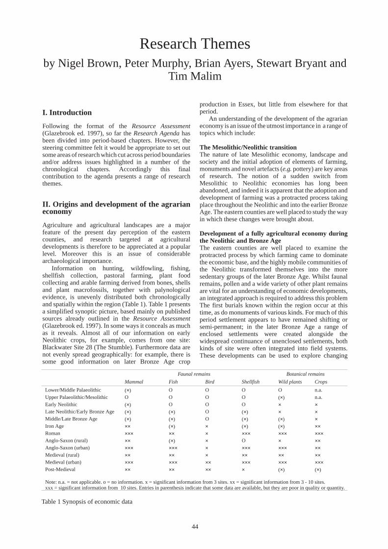
Research Themes by Nigel Brown, Peter Murphy, Brian Ayers, Stewart Bryant and
Tim Malim
I. Introduction
Following the format of the Resource Assessment (Glazebrook ed. 1997), so far the Research Agenda has been divided into period-based chapters. However, the steering committee felt it would be appropriate to set out some areas of research which cut across period boundaries and/or address issues highlighted in a number of the chronological chapters. Accordingly this final contribution to the agenda presents a range of research themes.
Table 1 Synopsis of economic data
Faunal remains Botanical remains
Mammal Fish Bird Shellfish Wild plants Crops
Lower/Middle Palaeolithic (×) O O O O n.a. Upper Palaeolithic/Mesolithic O O O O (×) n.a. Early Neolithic (×) O O O × × Late Neolithic/Early Bronze Age (×) (×) O (×) × × Middle/Late Bronze Age (×) (×) O (×) (×) × Iron Age ×× (×) × (×) (×) ×× Roman ××× ×× × ××× ××× ××× Anglo-Saxon (rural) ×× (×) × O × ××Anglo-Saxon (urban) ××× ××× × ××× ××× ×× Medieval (rural) ×× ×× × ×× ×× ×× Medieval (urban) ××× ××× ×× ××× ××× ××× Post-Medieval ×× ×× ×× × (×) (×)
Note: n.a. = not applicable. o = no information. x = significant information from 3 sites. xx = significant information from 3 - 10 sites. xxx = significant information from 10 sites. Entries in parenthesis indicate that some data are available, but they are poor in quality or quantity.
44
II. Origins and development of the agrarian economy
Agriculture and agricultural landscapes are a major feature of the present day perception of the eastern counties, and research targeted at agricultural developments is therefore to be appreciated at a popular level. Moreover this is an issue of considerable archaeological importance.
Information on hunting, wildfowling, fishing, shellfish collection, pastoral farming, plant food collecting and arable farming derived from bones, shells and plant macrofossils, together with palynological evidence, is unevenly distributed both chronologically and spatially within the region (Table 1). Table 1 presents a simplified synoptic picture, based mainly on published sources already outlined in the Resource Assessment (Glazebrook ed. 1997). In some ways it conceals as much as it reveals. Almost all of our information on early Neolithic crops, for example, comes from one site: Blackwater Site 28 (The Stumble). Furthermore data are not evenly spread geographically: for example, there is some good information on later Bronze Age crop
production in Essex, but little from elsewhere for that period.
An understanding of the development of the agrarian economy is an issue of the utmost importance in a range of topics which include:
The Mesolithic/Neolithic transition The nature of late Mesolithic economy, landscape and society and the initial adoption of elements of farming, monuments and novel artefacts (e.g. pottery) are key areas of research. The notion of a sudden switch from Mesolithic to Neolithic economies has long been abandoned, and indeed it is apparent that the adoption and development of farming was a protracted process taking place throughout the Neolithic and into the earlier Bronze Age. The eastern counties are well placed to study the way in which these changes were brought about.
Development of a fully agricultural economy during the Neolithic and Bronze Age The eastern counties are well placed to examine the protracted process by which farming came to dominate the economic base, and the highly mobile communities of the Neolithic transformed themselves into the more sedentary groups of the later Bronze Age. Whilst faunal remains, pollen and a wide variety of other plant remains are vital for an understanding of economic developments, an integrated approach is required to address this problem The first burials known within the region occur at this time, as do monuments of various kinds. For much of this period settlement appears to have remained shifting or semi-permanent; in the later Bronze Age a range of enclosed settlements were created alongside the widespread continuance of unenclosed settlements, both kinds of site were often integrated into field systems. These developments can be used to explore changing

perceptions of landscape and environment which allowed the development of a farming economy.
Agricultural developments during the Iron Age A greater knowledge of the agricultural economy of the region is likely to be a key to understanding the social, economic and cultural processes which took place during the Iron Age. Some problems and inadequacies associated with earlier studies have been outlined by Wiltshire and Murphy (1999). So far as palynological studies are concerned, the main problem is chronology: many pollen diagrams are not dated at all by radiocarbon; at others dates are interpolated on the assumption of constant sedimentation rates, and at others, sediments are dated by dubious cross-correlation with other sequences. At future investigations, coherent strategies to obtain dates suitable for mathematical modelling (Bayliss 1998) are needed for all periods, but especially the Iron Age. The charred plant macrofossil data have mostly come from small-scale sample excavations of settlement sites, and may not be typical of these sites as a whole. Similar problems apply to animal bones, with the added problem that at many sites there was no bone preservation at all. These problems need to be addressed, by sampling suitable sites on a large scale. Interpretation will also need to take account of the fact that deposits sampled are the results of complex cultural processes rather than simple residues of straightforward economic practices.
Fluctuations in the agricultural economy during the first half of the 1st millennium AD It seems clear that there was agricultural exploitation of a very wide range of environments in the region by the end of the Iron Age, and there was probably a continuum into the early Roman period. Possibly the later Roman period saw greater specialisation (including large-scale sheep farming in some areas) and pressure for higher outputs (e.g. for grain export) followed by sharp reduction in the 5th century. The eastern counties region is a key area for examining the inter-relationships of social and economic change during this period.
The impact of the development of towns on the surrounding countryside Production and processing of food for urban markets is a key element in understanding the relationship between towns and their rural hinterlands. The eastern counties, historically largely rural with few large towns, are well placed to study this problem.
Development and impact of the ‘agricultural revolution’ and Victorian High Farming The eastern counties region was at the centre of these developments. Evidence of their impact should be sought in both plant and animal remains, and the changing form of fields and farms.
The origins and development of field systems; their change and continuity A number of co-axial field systems have been identified in various parts of the region, potentially of very early origin. The field systems of East Anglia have long been recognised as distinctive and different to those of the midlands. Extensive hedgerow destruction in the second
half of the 20th century has had a severe impact on the ancient field systems of the region.
III. Urban development
The towns of East Anglia are examples of a social process which has evolved, often in an haphazard manner with numerous mutations, for well over a millennium, accelerating in the last 250 years. This process is the pan-European phenomenon of urbanisation whereby the increasing affluence, sophistication and centralisation of societies enables the fostering of an urban culture.
Study of urban culture, therefore, needs to be undertaken within a context which seeks to investigate, elucidate and interpret the urban process. It needs to explore the following themes:
• Urban origins and development within contemporary social and economic frameworks
• The complexity of towns as social and economic constructs
• The development cycle in towns and its impact upon society
• The influence of the urban process and market upon society in general
• The role of towns in the development of society specifically with regard to technology, economic, cultural and political innovation
In addition, archaeological study must recognise that the urban resource remains dynamic and that constant renewal of urban environments poses a challenge to research. Study needs to be targeted so that it informs understanding and thereby makes a positive contribution to the ongoing social process. Examination, assessment, synthesis and interpretation of the urban resource are activities which form part of the development of a modern urban society, helping to ensure vitality through informed awareness. In short, a research theme which seeks to understand the complexity of the urban process through time will contribute to that process in the future.
IV. Finds studies
Typological studies, scientific dating and physical characterisation of artefacts remains, for many periods, central to an understanding of chronology, and the agenda has highlighted a number of periods for which greater chronological precision is required — e.g. Iron Age ceramics. Such studies also offer opportunities to explore ethnicity, patterns of trade and manufacture. Topics of particular importance include:
Development of artefacts within the Neolithic and Bronze Age
The changing patterns of lithic technology, the acquisition of raw materials, developments in ceramics and the adoption of metallurgy together with the use, discard and deposition of artefacts, can be used to explore the changing attitudes and practices which created the dramatic transformations of this period. Amongst other things, artefact studies may also explore interaction within the region, between the region and other areas of Britain, and around the North Sea basin.
45

Production and exchange in the Iron Age, Roman and Anglo-Saxon periods The origin and variable development of aspects of market economy during these periods is important for understanding social organisation within the region. Evidence for regional workshops, access to/acceptance of continental imports, the impact and development of iron production and the development of agricultural production, are important topics for investigation throughout the period.
Trade and industry in the medieval and post-medieval period Study of patterns of trade within and beyond the region,
particularly with regard to the role of ports and other towns as centres of consumption and distribution, together with contrasts between urban and rural industries, could be used to elucidate social and economic developments. Studies of production centres and the distribution of their products — most obviously potteries such as those at Harlow and Lowestoft, but also other industries including cloth manufacture, fulling and dyeing, leather working and tanning, horn/bone working and metal-based industries — should also provide useful information in this regard.
V. Human remains
The principal limiting factor for the study of human bone is preservation. It is unfortunate, for example, that the most extensively excavated Early Anglo-Saxon cemeteries (e.g. Spong Hill, Mucking) were on sands and gravels where unburnt bone did not survive. Should funding be available in future for extensive cemetery excavations, then retrieval of human skeletal remains should be given at least equal weight with artefact retrieval when sites are being selected for excavation. Where a choice exists, sites on base-rich soils should be targeted. Human bone from the region has been reviewed by Mayes (1994). His principal conclusions are:
• The rarity of prehistoric human remains is even more marked in East Anglia than in other parts of the country, and this needs to be remedied.
• Material from the Roman period is dominated by burials from cemeteries at Colchester. Cemeteries elsewhere in the region require large-scale investigation.
• Compared to other regions, Anglo-Saxon human remains are plentiful, though over half of those known are cremations, and hence are of limited value.
• Medieval urban cemeteries, at Ipswich and Norwich for example, have been studied but more material from rural sites is required.
In addition, high precision radiocarbon dating of Middle Saxon cemeteries has been successfully undertaken at Stratton, Bedfordshire, just outside the region. More extensive application of this technique to human remains may help to clarify chronological problems.
VI. Selective survey
Particular geographical zones and types of deposit throughout the region, where the nature, extent and date of
archaeological deposits and sites is unclear and/or likely to be well preserved, should be selected for investigation. Amongst the most important areas/topics for such studies are:
Survey of claylands The origin, nature and development of settlement on claylands throughout the region is not well understood. Recent work such as that at Stansted and surveys around Haverhill and in the Waveney valley have suggested that settlement of these areas is more complex and of earlier origin than has often been assumed. Field survey using a variety of techniques should be undertaken to address these issues.
Palynology of sediment sequences It is important to recognise that much palynological research in this region was, until relatively recently, undertaken by Quaternary Ecologists, who have a different research agenda from archaeologists. Commonly, they are concerned with the early stages of post-glacial vegetation change, and with the establishment of long pollen sequences spanning most of the last 10,000 years. In consequence, radiocarbon determinations (where available at all) are often widely spaced within sediment cores, and few determinations are available for sediments post-dating about 3000BP. Frequently, published pollen analyses do not have sufficient chronological or spatial resolution to address the types of archaeological question specified above in the Period chapters. Priorities for future palynological study of deep sequences, based largely on comments by Patricia Wiltshire, include:
• The analysis of sediments from palaeochannels and other contexts directly related to archaeological sites.
• Focusing analysis on sections of cores which relate to specific archaeological questions or projects, rather than dissipating resources on outline analysis of entire sequences.
• The submission of series of radiocarbon samples, at close vertical intervals, from sediments of relevant date, and application of statistical techniques to enhance the precision of calibration.
• Multiple coring, so as to evaluate spatial heterogeneity in vegetation and avoid the unrealistically homogeneous picture of ancient landscapes commonly presented in the archaeological literature.
Buried land surfaces In Cambridgeshire, a considerable soils database has been established by Dr Charly French, for buried soils in the lower Nene, Welland and Ouse valleys in particular; but elsewhere data are patchy and sparse. Similarly, buried soil palynological studies have been undertaken in the fenlands of Norfolk, Cambridgeshire and Lincolnshire, with some work on the Essex coast but buried soils elsewhere have scarcely been analysed. Molluscan analysis of buried soils is clearly less widely applicable, being mainly suited to calcareous soils.
Land surfaces buried beneath, or intercalated within, sedimentary sequences, or beneath earthworks, represent one of the most important sources of palaeoenvironmental and economic information. Palaeosols are commonly present, and these have potential for studies of soil micromorphology, pollen or molluscs; semi-terrestrial
46

surfaces representing mires over which structures such as wooden trackways were laid are known; and surface-intact archaeological sites frequently occur.
Urban excavations are generally concerned with Roman and later deposits. It is, however, important to recognise that many urban sites are in river valley locations overlying earlier sediment sequences, sometimes associated with prehistoric material. The pressure to examine urban deposits should not lead to the underlying prehistoric material being neglected or ignored.
Topics of particular importance include:
• Continued micromorphological, palynological and molluscan studies of palaeosols intercalated within sediment sequences or beneath earthworks, particularly within the less intensively-studied parts of the region.
• Modelling palaeosurfaces beneath or within sediment sequences by borehole or geophysical survey. This enables sites located during quarrying or construction operations to be related to sub-surface topography, placing them within the context of a buried prehistoric landscape of palaeochannels and interfluves. Furthermore, if the depth and three-dimensional form of palaeosurfaces is known, then the likely effects of any developments involving removal of sediment cover and/or affecting hydrology and water-table levels may be assessed reliably and appropriate mitigation strategies developed.
• Evaluation of the scale and rate of damage to palaeosols under earthworks by tree roots and burrowing animals, especially at Scheduled Ancient Monuments, with mitigation where possible.
• Buried soils under linear earthworks such as defensive dyke systems provide an opportunity to examine transects across ancient landscapes, by using soil, pollen and/or molluscan studies to reconstruct local environments at a series of locations. Research projects involving spatial studies of this type would significantly enhance understanding of such systems.
River valleys Changes in hydrology, channel morphology and sedimentation, particularly the date at which large-scale alluviation began, are related to changes in base-levels and climate, but also to land use within the catchment. However, in general, studies in the region have been development-led and funded, so that isolated sections through palaeochannels have usually been examined rather than entire drainage systems, apart from in the lower Welland and Nene valleys. The main priority is:
• extensive study of entire catchments, employing aerial photography and a suite of sedimentological, geochemical, palaeomagnetic and palaeoecological techniques to reconstruct the alluvial histories of river valleys elsewhere in the region.
Wet site survey and evaluation
Coastal sites These provide unusually good palaeoeconomic and palaeoenvironmental data, but are extremely vulnerable to loss by erosion, and to damage or destruction associated with improvement of sea defences and Managed Set-back. Site types include pre-transgression (earlier prehistoric)
‘dryland’surface-intact sites with palaeosols, ‘submerged forests’, waterlogged wooden structures and artefacts, midden deposits, salterns and long sediment sequences with intercalated palaeosurfaces. Survey and limited follow-on investigation of sites on the Essex coast has been undertaken. Within the eastern counties, priorities include (see also Strategy p.52 below):
• Extending survey along the coasts of Suffolk and Norfolk. Information on the coastal archaeological resource in these counties is needed in order to define sites requiring immediate recording prior to inevitable destruction by erosion and for the development of management plans for significant sites which may, potentially, be preserved.
• Building on the survey work undertaken in Essex. A detailed research agenda for much of this area is provided by the Greater Thames Estuary Archaeological Research Framework (Williams and Brown 1999).
Wet river valley sites Many sites are directly threatened by water-table lowering associated with quarrying and river management, whilst in some areas eutrophication of sediments by nutrient-rich effluent is probably causing enhanced microbial activity and hence degradation of organic deposits.
Two river valley systems requiring further survey are:
• The nationally important Upper Palaeolithic and Mesolithic sites of the Lea Valley and other rivers in Hertfordshire and Essex. Hertfordshire County Council is taking the lead role in developing a Thames Northern Tributaries Project to evaluate these sites within their stratigraphic context (see Appendix, p. 2).
• The Norfolk/Suffolk Broads. Despite extensive medieval and later peat-cutting, areas of uncut peat, potentially including waterlogged prehistoric sites, still survive. They are threatened by eutrophication and by modern peat excavations. Definition of surviving uncut peat areas and evaluation of their state of preservation is necessary.
In addition to the above, despite the success of the Fenland Project, the Fens remain a key area for future research. Little is known about the early development of fen river systems, and few deeply buried sites have been investigated, consequently their nature and extent is not well understood.
VII. Political and social development withinterritories
The eastern counties region as defined for the purposes of this document contains a diverse archaeological resource outlined in part 1 of this framework (Glazebrook ed. 1997) and differential developments within the region offer considerable scope for investigation. For instance during the Bronze Age essentially similar cultural elements were used in markedly different ways, and in the Iron Age there is the opportunity to study developments within different tribal territories. Two such territories, those of the Iceni and Trinovantes, lay entirely within the five counties region, and the west of the region includes parts of a number of others. Similarly two Anglo-Saxon kingdoms, Essex and East Anglia, occupied most of the region, whilst a number of other territorial groupings occurred to the
47

west. There is thus the potential for examining the origins and development of these neighbouring, but rather different, social and political groupings.
Bibliography
Bayliss, A., 1998 ‘Some thoughts on using scientific dating in English archaeology and building analysis for the next decade’ in Bayley, J. (ed.), Science in Archaeology, 95–108
Glazebrook, J. ed., 1997
Research and Archaeology: a Framework for the Eastern Counties 1. resource assessment, E. Anglian Archaeol. Occ. Pap. 3
Mayes, S., 1994 ‘Archaeological research priorities for human remains in East Anglia’, Ancient Monuments Laboratory Rep. 30/94
Williams, J. and Brown, N. eds, 1999
An Archaeological Research Framework for the Greater Thames Estuary, (Essex County Council)
Wiltshire, P. and Murphy, P., 1999
‘Current knowledge of the Iron Age environment and agrarian economy of Norfolk and adjacent areas’ in Davies, J. and Williamson, T. (eds), The Land of the Iceni: the Iron Age of Northern East Anglia, 125–161
48

Strategy
49

Research Strategy by Keith Wade and Nigel Brown
I. Introduction
Each of the organisations forming the steering group (p.1) has been closely involved with research in the eastern counties. Production of the Research Framework was driven by a desire to provide a firm foundation for archaeological endeavour in the region both with regard to work arising from implementation of PPGs 16 and 15, and more specifically research-orientated projects. Once the Resource Assessment had established the extensive nature of the resource and the Research Agenda had demonstrated the scale and potential for future research within the region, the steering group clearly recognised a need for an explicit and coherent Research Strategy for the future.
The strategy set out below concentrates on those areas considered to be particularly important. It makes no pretence to be all-embracing, but aims to recommend priorities for research and ways in which these could be achieved. The research agenda has, amongst other things, identified a range of key gaps in our knowledge and the need to characterise the resource adequately. These are important issues, but data collection cannot be carried out, nor gaps filled in a conceptual vacuum, and the aim of research should be to increase understanding. Accordingly, project proposals arising from this framework will be constructed with synthesis and interpretation, both popular and academic, in mind. It is also recognised that development-led work will continue to form a very important contribution, and the framework should assist in providing a research focus for such work. Synthesis of the results of PPG 15/16 work, and
integration with other specifically research-orientated projects, will be essential.
If a truly integrated approach to future research in the eastern counties is to be achieved, all organisations carrying out projects in the region will need to be in broad agreement about how work is to be enabled and co-ordinated. This includes consensus about:
• organisation of future co-ordination • communication • approaches to Project Design • partnerships • IT and networking • science-based archaeology • education
Co-ordination The long established Eastern Counties Regional Coordination Group, whose members have a fundamental curatorial role in the area, will continue to play a key role. In addition, it is considered advisable, that the group set up to prepare this framework should continue to meet. It may be appropriate to co-opt others to review and discuss progress in implementing the framework.
Communication There is a continual need to raise general awareness of archaeological work taking place in the region, and promote and publicise the importance and interest of its archaeological resource. In the longer term, the steering group will aim to encourage a range of meetings and other methods of promoting and disseminating research in the region.
Approaches to Project Design There is a need to initiate new research projects within the region and this is considered further below. However, it is important, while in no way discouraging individual initiative, that from the beginning a consistent approach is established to the organisation and development of these projects. Across the region there is already general agreement on an approach integrating PPG 16 style brief and specifications and English Heritage MAP II. This approach should be extended and developed, and embrace:
• identification and defining of a specific research topic with reference to the Research Agenda and Strategy
• production of a research project brief/outline • agreement on a research design/specification • project implementation • monitoring procedures • progress reports depending on length or scale of
project • production of full report(s), synthesis and
communication of results
Partnerships While the Eastern Counties Group in itself represents a major partnership for the organisation of future research in the region, it is recognised that many groupings will need to be developed to progress a wide-ranging programme of research. For many years local societies and individuals have made, and will continue to make, a significant contribution. Projects developed from this research framework should aim to encourage, develop, and where necessary revitalise, local involvement in archaeological work. Many links with agencies, societies and academic institutions representing specialist fields of interest, will need to be established. This should extend beyond regional and national boundaries to the level of Europe, since the eastern counties represent a key part of a region based on the North Sea basin.
IT and networking It will be essential to ensure that the results from the diverse range of projects envisaged are readily accessible to all levels of users; this will be crucial to the creation and execution of projects. Accordingly, in the context of implementing ‘Unlocking the Past for the New Millennium’, the Eastern Counties Co-ordination Group should work to ensure that information is integrated with the appropriate existing national (NMR) and local (SMR) databases, and that there is compatibility of information
50

held on the region’s SMRs. It is also essential that steps are taken to ensure that this information is accessible to a range of potential users.
Science-based archaeology The resource assessment has established the complex nature of the archaeology of the eastern counties and many research questions on the agenda will only be progressed through a wide range of integrated projects. These will call upon many other disciplines, particularly in the fields of geomorphology, biology, geophysics (Bayley ed. 1998). This will involve both the application of existing techniques and the development of new ones. It will be necessary to establish links, to facilitate project development with appropriate partners and assist in the preparation of applications for projects in the region to the Science-based Archaeology Strategy Group for NERC grants and support. The English Heritage structure is vital in supplying regionally based advice on these issues.
Education Developing the vast educational potential of the archaeology of the eastern counties will be a primary task. Initially this is likely to be low key and linked to specific projects where there can be either site visits or lectures to selected groups. In the long-term this will be broadened, along with other general communication initiatives, in order to reach a much wider audience. Museums will have a vital role here in developing interpretative displays, publishing collections, and developing greater access to collections for all members of the community. Funding bodies, especially the Heritage Lottery Fund, must see public benefit demonstrated within any project which it supports. It will therefore be necessary to ensure development of the full educational potential of all archaeological projects. This should include threat-led work — already within the region, development control officers in Cambridgeshire and Peterborough regularly include requirements for site visits and talks in their briefs for developer-funded work. If the full educational potential of archaeological work within the region is to be realised, effective partnerships with a range of institutions, including schools, universities, museums and libraries, must be developed.
II. Current initiatives
An analysis of current archaeological initiatives (Appendix) indicates that within the region:
• most projects are undertaken by the county archaeological services.
• most projects rely on external funding, especially from English Heritage and RCHME.
• most projects are concerned with management of the resource rather than specifically addressing academic research issues or gaps in knowledge of particular periods.
• most of the research projects, not being undertaken by county archaeological services, are low budget, using volunteers, students, etc.
The county archaeological services have always been conscious of the research value of their work, even though development pressure and limited funding has led to a largely reactive approach. For this reason local
authority-based research in the region has essentially followed national initiatives offering grant aid. Regional priorities have tended to be a secondary consideration. Similarly, discussion of the relevance and value for money of research projects has been dominated by national considerations.
III. Selecting priorities for research
What is abundantly clear, from the foregoing research agenda, is that the resources currently available are well below the level required to address all of the research recommended. This is always likely to be the case and priorities must be identified for research in the region.
The current widespread agreement in the archaeological profession about the need for research frameworks is a positive step in the direction of targeting resources to the areas of greatest need in relation to archaeological research.
If this exercise is to be successful, however, there needs to be a mechanism to decide how priorities are to be selected and agreement by the funding bodies to align their policies to satisfy regional requests for funding.
At a national level, English Heritage’s criteria for selecting priorities is evolving. Its funding criteria for rescue projects, as set out in Exploring Our Past (English Heritage 1991), was the same as those which define a monument as being of national importance for the purposes of scheduling, namely:
• Period: it is important to consider for the record the types of monuments that characterise a category or period.
• Rarity: there are monument categories which are so rare that any destruction must be preceded by a record.
• Documentation: the significance of a site may be given greater weight by the existence of contemporary records.
• Group Value: the value of the investigation of a single monument may be greatly enhanced by association with a group of related contemporary monuments or with monuments of other periods. Dependent on the nature of the threat, in some cases, it is preferable to investigate the whole rather than isolated monuments within a group.
• Survival/Condition: the survival of archaeological potential is a crucial consideration.
• Fragility/Vulnerability: important archaeological evidence can be destroyed in some cases by a single ploughing or similar unsympathetic treatment and must be preceded by a record.
• Potential: on occasion the importance of the remains cannot be precisely specified, but it is important to document reasons for anticipating a monument’s probable existence and so justify the investigation.
The more recently drafted research agenda (English Heritage forthcoming) builds upon these criteria for national importance, with the aim of developing an approach reflecting ‘the greater determination to pursue research themes’and ‘wider interests (e.g. in landscapes)’. Projects seeking English Heritage resources should now seek to address five primary goals, ‘rather than merely identifying a site-type, period or theme’ cited in their research agenda.
51

These goals are:
1. Advancing understanding of England’s archaeology. 2. Securing the conservation of archaeological landscapes, sites and collections. 3. Supporting the development of national, regional and local research frameworks. 4. Promoting public appreciation and enjoyment of archaeology. 5. Supporting the development of professional infrastructure and skills.
Useful though these criteria are, it is necessary to attempt to address the concept of value for money in relation to the continual erosion of the resource. In prioritising projects in the context of regional research frameworks, it is recommended that in addition to the above points, the following five criteria are also considered:
1. The extent to which a project records data which would otherwise by damaged or destroyed (and which cannot be preserved in situ by more cost-effective means). 2. The extent to which a project addresses research questions (as outlined in the Agenda). 3. The extent to which a project utilises local knowledge and supports local expertise to further regionally specific research aims. 4. The extent to which a project benefits a wider public. 5. Cost effectiveness.
In relation to these criteria, certain projects can immediately be seen to offer better value. For example, it can often be argued that survey is better value than excavation, and multi-period survey is better value than themed survey as it allows the sharing of limited resources (organisation, travel) and inconvenience to landowners.
Research projects will fall into one or more of three categories:
• Management research — to inform management decisions about the conservation and presentation of the resource.
• Research which addresses threats to the resource — responding to specific potential damage from development, agriculture, afforestation, and natural erosion.
• Pro-active research — designed to further understanding of the region’s archaeology by addressing issues highlighted in the research agenda.
IV. Management research
The list of current archaeological initiatives (Appendix), indicates that most of the research in the region currently falls into the first category, and is largely sponsored by English Heritage. The Cambridgeshire County Farms Estate Survey (Malim 1990) is a recent example of good practice from within the region, and has led to the beneficial management of twelve Scheduled Ancient Monuments and a number of non-scheduled plough-damaged sites.
The importance of preserving the resource which has not been explored is critical to the success of future research. The largest sums of money are currently being invested in Urban Databases and Extensive Urban Surveys, which are proving useful for management, conservation and generating proposals for further
research. Whilst the urban archaeology of the eastern counties is of great interest and importance, the region is predominately rural. In relation to certain other agents of destruction at work within the region, development might be regarded as a minor, if high profile, problem.
Ploughing and sub-soiling since the Second World War is by far the most serious cause of damage to the resource. In Suffolk, for example, where 66% of land is arable, it follows that a large proportion of the archaeological resource has been denuded. Nationally, cultivation is considered to be the single biggest hazard to the long-term survival of archaeological monuments, yet it is cited as the reason for carrying out just 4% of rescue excavations (Darvill and Fulton 1998, 236–237).
In addition, the surface scatters of artefacts which are crucial evidence in the pursuit of many of our research agenda topics are being constantly dispersed by ploughing and collection by metal detectorists, who, for a variety of reasons, often do not report their finds. Some areas of the region, e.g. Norfolk, have long had effective liaison with metal detectorists, and this issue is currently being addressed by the Portable Antiquities Scheme (DCMS 1999), with schemes in operation in Suffolk and Norfolk and proposals to extend it to other counties under consideration.
The Rural White Paper (DOE/MAFF 1995) seeks a doubling of the woodland area in England in the next 50 years. In Suffolk, for example, this could mean 15% of land in the county as opposed to the current 7.4%. Forestry has an important role to play in enhancing the region’s environment, and the need to address potential conflict with preservation of archaeological remains is recognised in England’s Forestry Strategy (Forestry Commission 1999), and the MARS report (Darvill and Fulton 1998, 241).
At present only a small proportion of the resource can be protected from damage using voluntary agreements, and there will never be a mechanism which fossilises the majority of evidence (i.e. on arable land) in its current state of preservation. There is, therefore, an urgent need for extensive survey projects before the evidence is further degraded or destroyed, as a precursor to selective protection and recording. Priorities for such survey include:
Coastal erosion This is one of the most serious issues in the region as most of the coastline is eroding. English Heritage have recently agreed to initiate a project to survey the Norfolk and Suffolk coasts, a baseline survey project having previously been carried out on a large part of the Essex coast (Wilkinson and Murphy 1995).
Earthwork erosion In this highly arable region earthwork survival is of the utmost importance. Little systematic survey of ancient pasture and woodland has yet been undertaken. This should be a priority as a precursor to a management and protection strategy (extensive survey in Norfolk and limited work in Hertfordshire and Suffolk indicates the high potential of such surveys).
52

Identification of monument classes The region has many important monuments of unknown date — mainly cropmark enclosures and field systems, but including some major earthworks, only some of which are actually scheduled (e.g. Clare Camp). Establishing the date and function of these monument classes must clearly be a priority. The Essex Cropmark Enclosures Project (see Appendix) could be extended across the whole region as a precursor to their protection.
Historic landscape characterisation Characterisation of the region’s historic landscape types is a priority, and is already underway within the region (see p.57 and Appendix). A focus on landscapes offers many opportunities for academic and popular appreciation of the region’s archaeological resource (English Heritage 1998, 1 and 14–15).
V. Threat-led research
Recording, funded by developers and achieved through the implementation of PPGs 15 and 16 in the planning process, will continue to be the source of most research in the region. How then should the research agenda influence development control decisions?
The problem with creating research priorities is that they lend importance to particular archaeological sites or geographical zones to the detriment of others at the point in time when they are agreed. This, after all, is their purpose. This would not be a problem if the archaeological resource was only being diminished by archaeological research. The reality is that rescue archaeology will continue to be necessary and decisions about the importance of the archaeological resource threatened by development will still need to be made. Any research strategy must, therefore, consider the implications for rescue archaeology.
In summary, the problem is that the research strategy lends a relative importance to parts of the resource, at a point in time, but development control/rescue archaeology has to try to deal with absolute importance (as far as that is possible in relation to the current state of knowledge and archaeological theory).
‘Absolute’ importance PPG 16 places an emphasis on in situ preservation rather than excavation to preserve sites for future interrogation. In situations when preservation is not a feasible or reasonable option (in planning terms), a developer is expected to provide for a record of the site to be made, i.e. the data is transferred from the ground in which it lays to a series of records and finds stored in an alternative, secure, environment.
Although it has been little discussed, and no coherent theory has evolved, empirical evidence suggests that the response to a planning application specified by archaeological curators bears a relation to the perceived ‘importance’ of the deposits and/or structures.
The only yardstick of archaeological importance with any legal status is that used by the Secretary of State for Culture, Media, and Sport to determine whether a site is of national importance and qualifies for scheduling as an Ancient Monument. It seems likely that it is these criteria which influence current curatorial decisions, e.g. period,
rarity, documentation, survival/condition, fragility/ vulnerability, diversity, potential, group value.
There is little doubt, however, that sites at the top of the activity hierarchy are those classed as the most ‘important’, because they are artefact and structure rich, such as historic towns, large Roman settlements or Anglo-Saxon cemeteries. This bias is reflected both in the sites scheduled and those excavated on a large scale. It is hard to deny that such sites provide data quantity and in many cases data quality, but this huge quantity has always posed problems for the profession. The perceived obligation to publish all the data retrieved proved too big a task in some cases, and in others led to a seemingly endless stream of data with little in the way of analysis in relation to research questions.
This has resulted in repeated attempts to introduce selectivity into analysis and publication, from the Frere Report back in 1975 to the more recent Cunliffe Report in 1982. These principles are expanded in Management of Archaeological Projects (English Heritage 1991). There has been, over the last few years, an assertion that rescue archaeology, following the introduction of PPGs 16 and 15, has been poor value in relation to research, and that more selectivity should be employed over interventions related to development threats. Indeed Richard Morris has recently suggested that ‘archaeological remains deemed irrelevant to the questions are ignored’ and destroyed without record (Morris 1997). This view, if it gained support, would present the archaeological curator with a major problem because it is only sustainable if the data which is not retrieved will either never be required, or is preserved. As it is universally accepted that research priorities will change over time, it is difficult to define what data will never be required and the only sustainable strategy, therefore, is to preserve (in situ or by record) the resource which is not to be interrogated.
In a situation when an area of a site (or all of it) cannot be reasonably preserved in situ, the obligation to preserve by record is paramount. Analysis and publication, however, should be restricted to data collected with potential to answer current research questions.
The broad variety of research aims included in the research agenda are intended to be the principal means through which the research framework will support and inform the curatorial decision-making process. This should focus development-led archaeology towards clear academic aims and systematised dissemination of information. English Heritage (forthcoming) have highlighted the need for synthesis in their research agenda. Synthesis of work undertaken as a result of the implementation of PPG16 and 15 is a high priority, and this might be best approached on a thematic basis.
Sites affected by non-development threats The problem of recording sites threatened by agriculture, afforestation and coastal erosion has been largely ignored, probably because it is so big. However, a number of intiatives are taking place, or have been undertaken, within the region, including the Cambridgeshire County Farms Survey (Malim 1990), Fenland Management Project and survey in the coastal zone. Once the appropriate surveys have been completed (see Management Research p.53 above), management strategies can be prepared for each of these problem areas, recommending sites for preservation
53

and those for excavation with reference to the issues set out in the research agenda.
VI. Pro-active research
Aerial survey Of the current initiatives, aerial survey is the only long-term research which is producing valuable new data about the archaeological resource on a regional basis.
Field survey Despite the major Fenland Survey (Hall and Coles 1994), a variety of amateur work — much of it of high quality, survey carried out for evaluation purposes (Medlycott and Germany 1994), and projects such as those at Fransham, Norfolk, and in south-east Suffolk; systematic field survey projects have been virtually absent from large parts of the region.
In a highly arable region such as East Anglia, where surface scatters are crucial for the location of sites, field survey should be a priority. As all of the period papers in the research agenda recommend field survey, there is clearly a need to prioritise work. Highest priority should be given to:
• work on soil zones where surface scatters are known to be disappearing most rapidly.
• projects with multi-period objectives.
Excavation Very little research excavation has taken place in the region in recent years, with the exception of those at Sutton Hoo, funded by the British Museum and Society of Antiquaries.
Currently (see Appendix), excavation is being undertaken by Cambridge University in the Lark Valley (Suffolk), at Sedgeford (Norfolk) by the Sedgeford Hall Archaeological Research Project, and at Cressing (Essex), by Essex County Council. In addition, various sites in the region are being excavated by local archaeological societies. There is clearly enthusiasm within the profession for new research projects to address elements of the research agenda, some of which have been a source of frustration for many years. Such projects are, however, very expensive and there are unlikely to be sufficient resources available for more than one project at a time. Consideration should be given to at least one regional/international project designed to make use of European Commission funding opportunities.
Themes for regional/international research projects • origins and development of the agrarian economy. • regionality and territoriality. • origins of towns and trade. • interaction around the North Sea basin.
VII. Review
The Research Framework for the Eastern Counties is a point-in-time statement which will require review at regular intervals.
Certain lessons for the future can be learnt from the process of assembling this document.
The Resource Assessment (Glazebrook ed. 1997) was made more difficult than necessary by two constraints.
Firstly, data about the current state of knowledge is not easily accessible:
• SMRs have backlogs. • some data exists in paper copy only (drawings,
photographs, etc.). • some major excavations and surveys have not been
published and do not have accessible archives.
Access to SMR data and project archives must be improved, including the digital imaging of finds drawings/photographs.
The backlog post-excavation/publication of major sites must be dealt with as a matter of urgency, e.g. Ipswich, Brandon, Pakenham and West Row, Suffolk.
Secondly, there has been a lack of synthesis of data, especially from the hundreds of evaluations and excavations conducted since the introduction of PPGs 16 and 15 (see Resource Assessment and Introduction, above).
VIII. Funding
This will also be a major issue and if there is to be a successful future programme of archaeological research in the region, reinforcement of the partnership approach will be required. Currently, most projects are resourced by a range of organisations who contribute a mix of direct finance and/or resources in kind, often with significant funding by English Heritage and, with the merger of RCHME and English Heritage, there is a single organisation which is the principal funding body for archaeological research in the country.
It is envisaged that this kind of arrangement will continue for many new projects, particularly smaller ones. However, larger, more complex integrated projects will need significant levels of support requiring ‘new’ sources of funding. This will involve discussions with organisations in a position to sponsor archaeological projects like the period societies, trusts, NERC, English Nature, Environment Agency, and Heritage Lottery Fund (HLF).
The HLF is potentially another major funding body for archaeological projects, and its Archaeology Guidance Notes were issued in September 1998. HLF will accept applications for the funding of archaeological work in five categories:
1. Fieldwork of all types in connection with heritage which is threatened by, or in the process of, environmental erosion. Environmental erosion as defined includes coastal erosion, ploughing and water desiccation. 2. The non-destructive record of vulnerable, little known, or poorly understood heritage of local significance. Examples cited include hedgerows, graveyards and artefact collections. 3. The enhancement of existing Sites and Monuments Records services in order to make information more accessible to users. 4. Synthesis of the results of past fieldwork or research exercises in a discrete geographical area. 5. The completion of analysis and the dissemination of the results of nationally significant excavations in cases where the excavator is no longer practising.
54

There is also a major opportunity to explore the potential for EU funding. The eastern counties, as an integral part of a region centred on the North Sea basin, are in a very good position to develop European partnerships.
IX. Future action
The present and the future are of course inextricably products of the past, and we cannot properly understand where we are going and why, without understanding our cultural origins. We have a duty to cherish and protect our historic environment, and I can assure you that our Government is committed to doing so. Alan Howarth (1999a)
I know that This World Is a World of imagination and Vision. William Blake (letter to Dr Trusler 23 August 1799)
Publication of this framework is not an end in itself but a first step, from which programmes of work will be developed to enhance understanding, conservation and appreciation of the region’s archaeological resource. This final section of the framework sets out a range of issues and objectives, which all those organisations represented on the steering committee intend to pursue over the next few years.
Future work will be developed within a holistic vision of the region’s historic environment, and as such is in line with current government thinking recently expounded in three ministerial speeches, to the European Association of Archaeologists (Howarth 1999a), the English Historic Towns Forum (Howarth 1999b) and the European Archaeological Council (Howarth 1999c). The importance of moving from a site-based approach to addressing the historic environment as a whole is clearly set out in Sustaining the historic environment: new perspectives on the future ‘…it is too easy to look only at separate sites, and to ignore the fact that the whole of our environment has been shaped and created by people and their work. The past, and its impact on the landscape, can be appreciated in every part of the country, not necessarily because of particular buildings or monuments but because of the detail, the fundamental grain and the basic character of the landscape in its entirety.’ (English Heritage forthcoming, 3). Central to this approach is the concept of sustainability, the key principles of which have been summarised elsewhere (English Heritage forthcoming) and include:
• developing stronger understanding of the historic environment, and promoting wide awareness of its role in modern life.
• looking at the environment as a whole. • deciding which elements of the environment are to be
conserved at all costs (‘critical’ assets), or subject to limited change provided that the overall character of the resource is maintained (‘constant’ assets), or suitable for exchange in return for other benefits (‘tradable’ assets).
• ensuring that decisions about the historic environment are made on the basis of the best possible information.
Implementation of the framework will be governed by these principles. In particular the research framework has a key role to play in defining, for the region, ‘critical, constant and tradable’ assets.
The research framework represents a contribution to developing regional strategies which are concerned with the historic environment in the east of England. As such, publication and implementation of the framework are key objectives of the ALGAO East of England regional strategy (ALGAO 2000). The ALGAO strategy and the framework are complementary documents, which should be read and used in conjunction. Both documents may be viewed as supporting and augmenting the East of England Cultural Forum’s draft Cultural Strategy (EECF 1999) and the East of England Development Agency’s draft Economic Development Strategy (EEDA 1999).
It is intended that the steering committee which produced this framework will continue to meet, to develop, review and eventually revise it. It is important to realise that the framework is not intended to be exclusive, and it is anticipated that anyone undertaking work within the region will wish to refer to it. In order to encourage use of the framework, and effective review and updating, the steering committee will seek to augment and extend its representation.
As noted above (p.2), English Heritage’s three key concepts for ‘Advancing Understanding of England’s Archaeology’ (forthcoming, 16), together with the principles of sustainability, will underpin all work arising from the research framework. In addition, set out below are a number of key objectives central to the implementation of it.
Maximising the resources available • Financial. As set out above (p.54) this will be crucial to
the successful pursuit of research within the region. The eastern counties have a vital role to play as part of a region based around the North Sea and efforts will be made to develop projects with European partners. At a national level funding will be sought from English Heritage, NERC, the HLF and the period societies. Efforts will be made to explore opportunities for funding arising from the developing East of England regional structures. Locally there are a number of trusts and societies which can support archaeological work, and efforts will be made to engage them in research within the region. Most archaeological work within the region is now, and is likely to continue to be, developer funded. This framework has an important role in ensuring that the full research value of developer funded work is realised and it is anticipated that this will largely be achieved through implementation of the key objectives set out here.
• Personnel. Endeavour to ensure that the expertise and interest of all those working within the region are deployed and developed, to achieve best value in understanding the archaeological resource. In particular, to encourage local groups, societies and individuals to direct their efforts, expertise and enthusiasm towards achieving the aims of this framework.
• Academic. Encourage academic institutions within and beyond the region to pursue their research through engaging with the archaeological resource in the eastern counties.
55

Plate XI Aerial photograph of the causewayed enclosure on a gravel terrace overlooking the Thames estuary at Orsett, Essex. The corner of an Iron Age rectangular enclosure can be seen to the left of the photograph, the group of ring-ditches are of Anglo-Saxon date. Cropmarks of a trackway and rectilinear fields/enclosures can also be seen. The existing hedgerows and sinuous road are elements of a rectilinear pattern of land division, of ancient origin, character
istic of large parts of south and east Essex. Ostensibly a photograph of a Neolithic site, the complexity revealed is typical of much of the region, and is a good example of the need to move from a site-based approach to one which
considers the historic environment as a whole. (Cambridge University Collection of Air Photographs: copyright reserved, K17-U 117, 13 June 1970)
56

Synthesis The need for synthetic research is constantly reiterated throughout this framework, and the pursuit of synthesis and interpretation is central to its implementation.
• Ensure that the wealth of information in the region’s museum collections, SMRs and excavation archives is appreciated and accessible.
• Develop projects which utilise these resources to offer interpretations of the region’s past.
• Ensure that where proposals for analysis are being prepared, opportunities for the inclusion and interpretation of the results of earlier interventions are explored.
Preservation by record Ensure that threat-led fieldwork addresses clear research issues.
• Ensure that briefs prepared by curators identify areas of key research potential.
• Ensure that specifications prepared by contractors address areas of key research potential.
• Ensure that proposals for analysis explore appropriate ways in which data can be used to address key areas of research.
Research themes Ensure that the potential of the region’s archaeological resource to address major research issues is appreciated and developed. Many of these are set out in the Agenda (above), but it is anticipated that those for immediate attention will include:
• Origins and development of an agrarian economy. This region is central to an understanding both of the adoption/development of agriculture in the Neolithic and Bronze Age, and for later developments in the medieval and post-medieval periods.
• Settlement patterns and field systems. The region’s distinctive patterns of fields, farms, hamlets and villages are vital to an understanding of past social organisation and economy, and form the matrix of the historic environment.
• Urban development. The region has a key role to play in study of the origin and development of towns, at a local, regional and European level.
• Finds Studies. There is a strong tradition of artefact studies within the region, and these will be developed both for their contribution to wider research questions and for their intrinsic interest.
Even before publication, preparation of the framework has set in train a range of initiatives, all supported by English Heritage, which cover the region as a whole or deal with specific areas of it. A Historic Landscape Character Project, whose work is complete in Suffolk, is underway in Hertfordshire and Essex and will be extended to include Cambridgeshire and Norfolk, and this will provide an important new baseline survey. This project will allow fresh appreciation and understanding of the rich
diversity of the region’s landscape, and will underpin a range of other initiatives. Indeed, a Field Systems Project is already being developed which will run in tandem with the Historic Landscape Character Project (see Appendix). It will provide an opportunity to investigate the origins and development of the distinctive field patterns of the region for comparison with work already undertaken on the fields of the Midlands.
The framework is also providing a context in which attention can be focused on areas which had previously been somewhat neglected, since they form boundary zones between different jurisdictions. The Stour Valley Project is examining a large area of the Stour valley as part of MARS implementation (see Appendix). The first phase of work is underway and will provide a GIS-based synthesis and interpretation of the remarkable range of cropmarks in the valley. The area, which forms part of the boundary between Essex and Suffolk, is relatively unaffected by development threats but has seen intensification of arable cultivation. Later stages of the project will seek to engage all those with an interest in the Stour landscape in developing better management and protection of the cropmark landscape.
A project to consider the surviving extent and potential of the environmental deposits in the Lea Valley, and other northern tributaries of the Thames, is also under consideration. This will involve co-operation not only between Hertfordshire and Essex but with Greater London, beyond the area covered by this framework. The long coastline and numerous creeks and estuaries of the region are also a focus for current research initiatives. A baseline desktop survey of the Suffolk and Norfolk coasts is currently underway, and further work is also being undertaken around the Essex coast to augment the results of the Hullbridge survey (see Appendix). Amongst other things this work will enhance our understanding of the eastern counties as part of a European North Sea region, a concept which is being pursued in Europe with the development of Intereg projects.
These represent some of the major areas of new work which will further the aims of this framework. Numerous other initiatives are underway, many of which are outlined in the Appendix. There is a symbiotic relationship between the projects being developed, and the framework will have an important role to play in developing a dynamic and collaborative research culture, which will ensure that the archaeology of the eastern counties is increasingly appreciated and understood at a local, national and European level as the 21st century progresses.
Returning to the quotations at the start of this section, for our present purposes the key words from the first are ‘understand’ and ‘understanding’, from the second ‘Vision’ and ‘Imagination’. To realise the full potential of the research framework, we must aim to prepare interpretations of the region’s archaeological resource which advance understanding of the past at every level. To do this successfully will require vision and imagination.
57

Bibliography
ALGAO, 2000 Taking a Lead in Safeguarding the Historic Environment of the East of England
Bayley, J. ed., 1998 Science in Archaeology: an Agenda for the Future
Cunliffe, B.W., 1982
The Publication of Archaeological Excavations, (report of a joint working party: Council for British Archaeology, English Heritage)
Darvill, T. and Fulton, A., 1998
The Monuments at risk Survey of England 1995: Main Report
Department of Culture, Media and Sport (DCMS), 1999
Portable Antiquities; Annual Report 1997–98
DOE/MAFF, 1995 Rural England — A Nation Committed to a Living Countryside
East of England Development Agency, 1999
Towards a Regional Economic Strategy for the East of England
East of England Cultural Forum, 1999
Towards an East of England Cultural Strategy
English Heritage, 1991
Management of Archaeological Projects
English Heritage, 1991
Exploring Our Past — Strategies for the Archaeology of England
English Heritage, 1998
Capital archaeology: Strategies for sustaining the historic legacy of a world city
English Heritage, forthcoming
Exploring our Past 1998
Forestry Commission, 1999
A New Focus for England’s Woodlands: Strategic Priorities and Programmes
Frere, S.S., 1975 Principles of Publication in Rescue Archaeology
Glazebrook, J. ed., 1997
Research and Archaeology: a Framework for the Eastern Counties 1. resource assessment, E. Anglian Archaeol. Occ. Pap. 3
Hall, D. and Coles, J., 1994
Fenland Survey: An essay in landscape and persistence
Howarth, A., 1999a Speech to European Associat ion of Archaeologists Conference, Bournemouth
Howarth, A., 1999b Speech to English Historic Towns Forum Conference, Hereford
Howarth, A., 1999c Speech to the European Archaeological Council
Malim,T., 1990 Archaeology on the Cambridgeshire County Farms Estate
Medlycott, M. and Germany, M., 1994
‘Archaeological fieldwalking in Essex, 1985–93: interim results’, Essex Archaeol. Hist. 25, 14–28
Morris, R., 1997 ‘Right and Wrong Ways to do Archaeology’, British Archaeology, November, 11
Wilkinson, T. and Murphy, P., 1995
Archaeology of the Essex Coast I: The Hullbridge Survey, E. Anglian Archaeol. 71
58
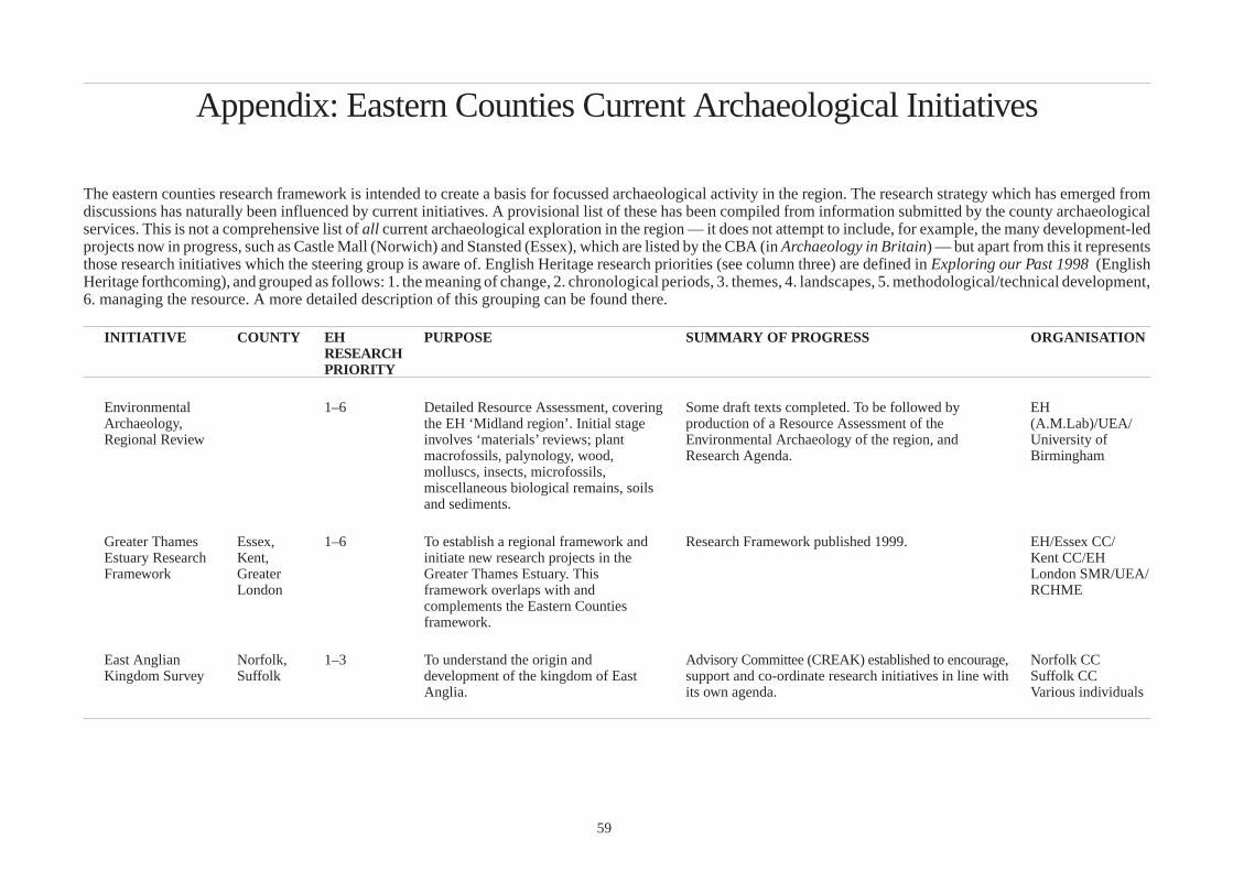
Appendix: Eastern Counties Current Archaeological Initiatives
The eastern counties research framework is intended to create a basis for focussed archaeological activity in the region. The research strategy which has emerged from discussions has naturally been influenced by current initiatives. A provisional list of these has been compiled from information submitted by the county archaeological services. This is not a comprehensive list of all current archaeological exploration in the region — it does not attempt to include, for example, the many development-led projects now in progress, such as Castle Mall (Norwich) and Stansted (Essex), which are listed by the CBA (in Archaeology in Britain) — but apart from this it represents those research initiatives which the steering group is aware of. English Heritage research priorities (see column three) are defined in Exploring our Past 1998 (English Heritage forthcoming), and grouped as follows: 1. the meaning of change, 2. chronological periods, 3. themes, 4. landscapes, 5. methodological/technical development, 6. managing the resource. A more detailed description of this grouping can be found there.
INITIATIVE COUNTY EH PURPOSE SUMMARY OF PROGRESS ORGANISATION RESEARCH PRIORITY
Environmental 1–6 Detailed Resource Assessment, covering Some draft texts completed. To be followed by EH Archaeology, the EH ‘Midland region’. Initial stage production of a Resource Assessment of the (A.M.Lab)/UEA/ Regional Review involves ‘materials’ reviews; plant Environmental Archaeology of the region, and University of
macrofossils, palynology, wood, Research Agenda. Birmingham molluscs, insects, microfossils, miscellaneous biological remains, soils and sediments.
Greater Thames Essex, 1–6 To establish a regional framework and Research Framework published 1999. EH/Essex CC/ Estuary Research Kent, initiate new research projects in the Kent CC/EH Framework Greater Greater Thames Estuary. This London SMR/UEA/
London framework overlaps with and RCHME complements the Eastern Counties framework.
East Anglian Norfolk, 1–3 To understand the origin and Advisory Committee (CREAK) established to encourage, Norfolk CC Kingdom Survey Suffolk development of the kingdom of East support and co-ordinate research initiatives in line with Suffolk CC
Anglia. its own agenda. Various individuals
59

INITIATIVE COUNTY EH PURPOSE SUMMARY OF PROGRESS ORGANISATION RESEARCH PRIORITY
Urban Databases 6 To produce an urban database as part of Ipswich — Research Design awaits approval by EH. EH funding Ipswich Suffolk a nationwide assessment of the urban Colchester — The project is under discussion between Suffolk CC, Colchester Essex archaeological resource by EH. Colchester BC, the Museum Service and EH. A pilot Essex CC, CBC St Albans Herts exercise is understood to have been agreed. St Albans DC Norwich Norfolk St Albans — UAD and assessment completed. Norfolk CC Cambridge Cambs Norwich — UAD in progress.
Cambridge — UAD to be completed 1999. Cambs CC, City C
The topography of Cambs 3 Analyse archaeological and Data collection and text completed. First of two papers Cambs CCAFU and Saxon and documentary data to provide models for submitted for publication. Hunts Local Hist medieval urban development. Soc Huntingdon
Towns, ports and Cambs 3 Bring together field, artefactual, Some analysis of Hunts urban centres executed and Cambs CCAFU/ trade in the documentary and landscape data to three papers presented . personal research medieval fenland provide models and comparisons of
urban dynamics.
Anglo-Saxon Cambs 2 Establish status of Anglo-Saxon sites in Database produced. Regional study much discussed. Cambs CC, Norfolk Survey of East eastern counties. Stalled for two years. CC, Suffolk CC, Anglia (Cambs Essex CC, Herts CC part) and EH
Aerial Survey Essex, 4–5 To carry out an annual programme of Aerial survey is carried out annually targeting EH/ Project Suffolk, targeted aerial survey. particular types of site or specific areas at appropriate County Councils
Herts, times. In 1998 the Essex survey targeted large Norfolk inter-tidal sites such as wrecks, fish-weirs and other
coastal industry sites.
National Mapping Essex 4–6 To map archaeological information from Essex NMP still has several years to run before Essex CC/EH Programme all available oblique and selected completion. The coast has been completed and the
vertical aerial photographs. Information north-west of the county is now being mapped. GIS is is being mapped to national standards increasingly used in the mapping and analysis of sites. and recorded in the RCHME ‘Morph’ A draft synopsis is being prepared for publication of database system. the results in East Anglian Archaeology.
60

INITIATIVE COUNTY EH PURPOSE SUMMARY OF PROGRESS ORGANISATION RESEARCH PRIORITY
Thames Northern Essex, 6 Identification of archaeologically sensitive Project outline submitted to EH in 1996. Currently Outline PD funded by Tributaries Survey Herts alluvial deposits in the Lea Valley. (Jan 2000) being revised in light of EH comments. Herts CC/Essex CC
Stour Valley Essex, 2, 4–6 Synthesis and interpretation of existing First stage of project, the analysis of the cropmark EH, Project Suffolk cropmark and field survey data. Intended landscape in a GIS environment, carried out Essex CC
to build on the work of MPP, MARS and the Cropmark Enclosures Project. To enhance understanding and management of a monument-rich but heavily ploughed landscape.
1999–2000. Updated project design being considered. Suffolk CC
Historic Suffolk, 4, 6 To define historic landscape types and Suffolk — Project complete. EH funding Landscape Herts, map them. Underway in Herts, 1999. Suffolk CC Characterisation Essex Due to start in Essex in 2000. Herts CC Project
Rapid Coastal Norfolk, 6 To locate sites and form basis of recording Desk-based survey began in 1999. Project Design for EH funding. Assessment Survey Suffolk strategy prior to coastal erosion. field survey in preparation. Norfolk/Suffolk CC
UEA
Coastal Grazing Essex 4, 6 Earthwork survey of major areas of Survey work complete and report in preparation. EH/RCHME, Marsh Survey surviving grazing marsh at Blue House
Farm and Old Hall Marsh, to complement earlier work at Tollesbury Wick.
Essex CC
Cropmark Essex 2, 5 To locate and sample for the purposes of Four sites were examined. Two proved to be early EH, Essex CC Enclosures Project establishing the date and possible medieval probably windmill sites, one was of Neolithic
function of particular classes of date associated with a long mortuary enclosure, the enclosure. Attention was directed to other was Bronze Age probably a large barrow. Deep henges or hengiform enclosures. alluvial/colluvial sequences adjacent to the latter two
sites were examined and yielded a variety of environmental deposits which are currently being radicarbon dated. Reports in preparation.
Field Systems in Suffolk, 6 Characterise field systems in region. Two-year project, started in January 2000. EH funding, East Anglia Essex, Suffolk, Essex and Project Norfolk Norfolk CC
61

INITIATIVE COUNTY EH PURPOSE SUMMARY OF PROGRESS ORGANISATION RESEARCH PRIORITY
Farmsteads Suffolk 6 To aid listing and conservation Pilot study undertaken and draft report produced 1998 EH funded, Susanna Wade Martins and Philip Aitkens
Moated Sites Suffolk 2, 6 Documentary and field survey. In progress E.Martin private Garden Canals research
Nautical Suffolk 3, 6 Recording wrecks etc. Ongoing. Stuart Bacon – Archaeology Suffolk Underwater
Studies
Church roofs Suffolk 3, 6 Record/analyse all medieval church Report in draft. B.Haward and roofs. P.Aitkens
Earthworks Survey Norfolk 6 To map, and provide analytical Started in May 1994. Survey in progress. 159 sites Norfolk CC (FAD), descriptions of, significant earthworks surveyed so far, mostly at 1:1000. Due for completion Brian Cushion including newly identified examples. in 2000. Research documentary background. SMR enhancement; resource management and conservation including MPP.
Fenland Cambs 6 Ongoing management of fenland sites Various excavations, publication of Fenland Research EH, CAU, Cambs Management identified in Fenland Survey. CC Project
Village Earthwork Cambs 6 Survey of earthworks in historic villages Pilot survey complete.To be extended to further Cambs CCAFU, Survey in S.Cambs. villages and synthetic publication to be produced. SCDC
Cambs Dykes Cambs 4 Investigation of the origins and function First paper published 1997; second stage of research to Cambs CC AFU, Project of the great linear earthworks be taken forward by 2000 — to examine terminals, EH
collect samples for radiocarbon dating and environmental analysis; and to consider regional and continental parallels.
62

INITIATIVE COUNTY EH PURPOSE SUMMARY OF PROGRESS ORGANISATION RESEARCH PRIORITY
Roman roads in Cambs 2 Catalogue and analyse excavated Database complete; short paper written for An Cambs CCAFU Cambs evidence for Roman roads Historical Atlas of Cambridgeshire. funded
Ancient Woodland Herts CC 6 Identification and survey of Interim report in 1999. Herts CC, B.Perry, Survey archaeological remains in woodland. T.Williamson
Industrial Sites Essex 1, 3, 6 To locate and establish baseline data for Extensive surveys to date included workhouses, Essex CC Survey various classes of industrial site, enhance hospitals, maltings, lime kilns, historic boundary Various
the SMR and establish priorities for markers, iron foundries, first and second world war conservation and/or further recording. airfields, public water supply industry and
telecommunications industry in Chelmsford. With local societies, post-graduate students and volunteers, surveys are being undertaken for brick and tile works, textiles, Chelmer and Blackwater Navigation and farmsteads.
Industrial Sites Norfolk 1, 3, 6 To locate and establish baseline data for Surveys in progress include watermills, bridges, fixed NIAS, B.Funnell, survey various types of industrial site. defences, steam drainage mills in the Broadland area, D.Manning, C.Bird,
gold and silver smithing and the canalisation and M.Manning, industrial history of the River Ant. A.Ward, M.Fewster
WWII Defences Essex, 2, 6 To locate and establish baseline data for Survey of WWII defences aims to record all known EssexCC Survey Norfolk, WWII defence sites, update the SMR sites in the county. After initial exercises, the Essex Norfolk CC (FAD)
Cambs and establish priorities for conservation survey has been concentrating on the ‘stop lines’ Local groups and and/or further recording. which have been completed. With funding from the
Essex Heritage Trust the survey has moved on to a thematic approach, beginning with the anti-aircraft battery sites. An interim report on the project from 1993 to 1998 has been prepared. Cambs — Survey largely complete and fed back to
individuals
NMR and SMRs; National base at Duxford, Cambs. Mike Osborne, CBA
Cold War Survey Cambs 2, 6 Programme to list and preserve examples Survey underway; National base at RCHM Brooklands RCHM of structures from the cold war. Avenue, Cambs
63
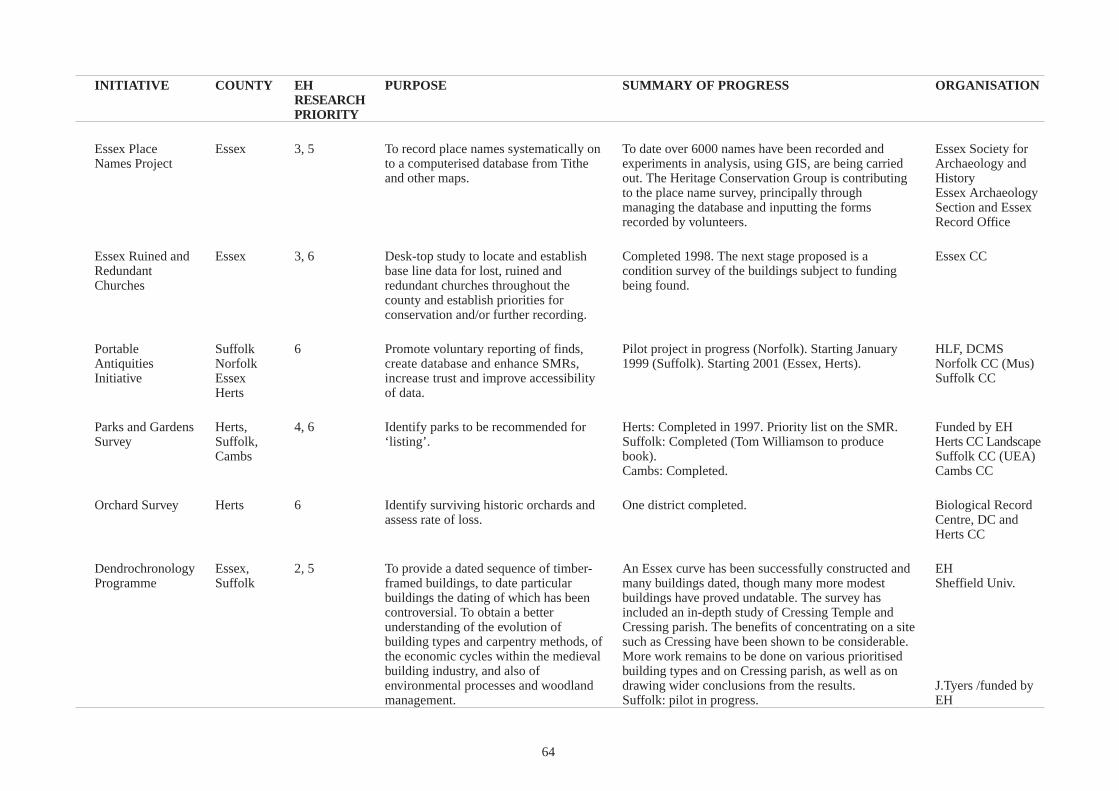
INITIATIVE COUNTY EH PURPOSE SUMMARY OF PROGRESS ORGANISATION RESEARCH PRIORITY
Essex Place Essex 3, 5 To record place names systematically on To date over 6000 names have been recorded and Essex Society for Names Project to a computerised database from Tithe experiments in analysis, using GIS, are being carried Archaeology and
and other maps. out. The Heritage Conservation Group is contributing History to the place name survey, principally through Essex Archaeology managing the database and inputting the forms Section and Essex recorded by volunteers. Record Office
Essex Ruined and Essex 3, 6 Desk-top study to locate and establish Completed 1998. The next stage proposed is a Essex CC Redundant base line data for lost, ruined and condition survey of the buildings subject to funding Churches redundant churches throughout the
county and establish priorities for conservation and/or further recording.
being found.
Portable Suffolk 6 Promote voluntary reporting of finds, Pilot project in progress (Norfolk). Starting January HLF, DCMS Antiquities Norfolk create database and enhance SMRs, 1999 (Suffolk). Starting 2001 (Essex, Herts). Norfolk CC (Mus) Initiative Essex increase trust and improve accessibility Suffolk CC
Herts of data.
Parks and Gardens Herts, 4, 6 Identify parks to be recommended for Herts: Completed in 1997. Priority list on the SMR. Funded by EH Survey Suffolk, ‘listing’. Suffolk: Completed (Tom Williamson to produce Herts CC Landscape
Cambs book). Suffolk CC (UEA) Cambs: Completed. Cambs CC
Orchard Survey Herts 6 Identify surviving historic orchards and One district completed. Biological Record assess rate of loss. Centre, DC and
Herts CC
Dendrochronology Essex, 2, 5 To provide a dated sequence of timber- An Essex curve has been successfully constructed and EH Programme Suffolk framed buildings, to date particular many buildings dated, though many more modest Sheffield Univ.
buildings the dating of which has been buildings have proved undatable. The survey has controversial. To obtain a better included an in-depth study of Cressing Temple and understanding of the evolution of Cressing parish. The benefits of concentrating on a site building types and carpentry methods, of such as Cressing have been shown to be considerable. the economic cycles within the medieval More work remains to be done on various prioritised building industry, and also of building types and on Cressing parish, as well as on environmental processes and woodland drawing wider conclusions from the results. J.Tyers /funded by management. Suffolk: pilot in progress. EH
64
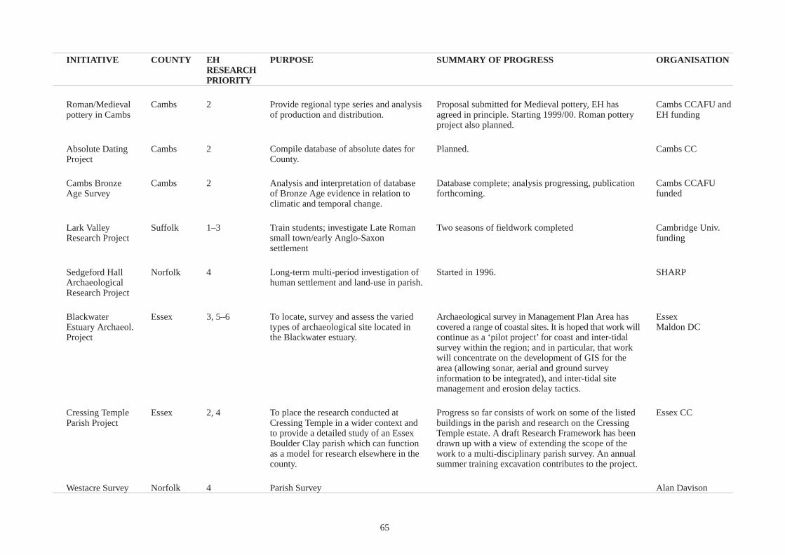
INITIATIVE COUNTY EH PURPOSE SUMMARY OF PROGRESS ORGANISATION RESEARCH PRIORITY
Roman/Medieval Cambs 2 Provide regional type series and analysis Proposal submitted for Medieval pottery, EH has Cambs CCAFU and pottery in Cambs of production and distribution. agreed in principle. Starting 1999/00. Roman pottery
project also planned. EH funding
Absolute Dating Cambs 2 Compile database of absolute dates for Planned. Cambs CC Project County.
Cambs Bronze Cambs 2 Analysis and interpretation of database Database complete; analysis progressing, publication Cambs CCAFU Age Survey of Bronze Age evidence in relation to
climatic and temporal change. forthcoming. funded
Lark Valley Suffolk 1–3 Train students; investigate Late Roman Two seasons of fieldwork completed Cambridge Univ. Research Project small town/early Anglo-Saxon
settlement funding
Sedgeford Hall Norfolk 4 Long-term multi-period investigation of Started in 1996. SHARP Archaeological human settlement and land-use in parish. Research Project
Blackwater Essex 3, 5–6 To locate, survey and assess the varied Archaeological survey in Management Plan Area has Essex Estuary Archaeol. types of archaeological site located in covered a range of coastal sites. It is hoped that work will Maldon DC Project the Blackwater estuary. continue as a ‘pilot project’ for coast and inter-tidal
survey within the region; and in particular, that work will concentrate on the development of GIS for the area (allowing sonar, aerial and ground survey information to be integrated), and inter-tidal site management and erosion delay tactics.
Cressing Temple Essex 2, 4 To place the research conducted at Progress so far consists of work on some of the listed Essex CC Parish Project Cressing Temple in a wider context and buildings in the parish and research on the Cressing
to provide a detailed study of an Essex Temple estate. A draft Research Framework has been Boulder Clay parish which can function drawn up with a view of extending the scope of the as a model for research elsewhere in the work to a multi-disciplinary parish survey. An annual county. summer training excavation contributes to the project.
Westacre Survey Norfolk 4 Parish Survey Alan Davison
65
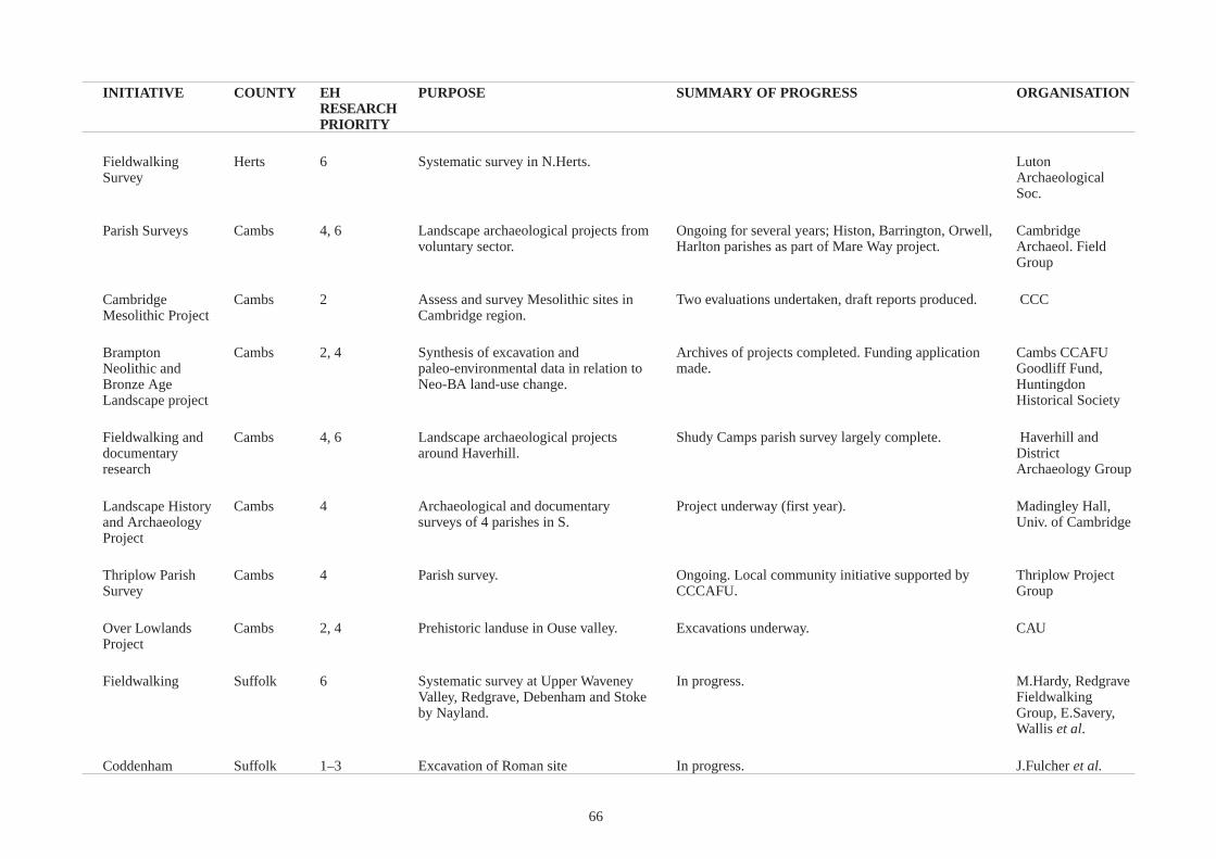
INITIATIVE COUNTY EH PURPOSE SUMMARY OF PROGRESS ORGANISATION RESEARCH PRIORITY
Fieldwalking Herts 6 Systematic survey in N.Herts. Luton Survey Archaeological
Soc.
Parish Surveys Cambs 4, 6 Landscape archaeological projects from Ongoing for several years; Histon, Barrington, Orwell, Cambridge voluntary sector. Harlton parishes as part of Mare Way project. Archaeol. Field
Group
Cambridge Cambs 2 Assess and survey Mesolithic sites in Two evaluations undertaken, draft reports produced. CCC Mesolithic Project Cambridge region.
Brampton Cambs 2, 4 Synthesis of excavation and Archives of projects completed. Funding application Cambs CCAFU Neolithic and paleo-environmental data in relation to made. Goodliff Fund, Bronze Age Neo-BA land-use change. Huntingdon Landscape project Historical Society
Fieldwalking and Cambs 4, 6 Landscape archaeological projects Shudy Camps parish survey largely complete. Haverhill and documentary around Haverhill. District research Archaeology Group
Landscape History Cambs 4 Archaeological and documentary Project underway (first year). Madingley Hall, and Archaeology surveys of 4 parishes in S. Univ. of Cambridge Project
Thriplow Parish Cambs 4 Parish survey. Ongoing. Local community initiative supported by Thriplow Project Survey CCCAFU. Group
Over Lowlands Cambs 2, 4 Prehistoric landuse in Ouse valley. Excavations underway. CAU Project
Fieldwalking Suffolk 6 Systematic survey at Upper Waveney In progress. M.Hardy, Redgrave Valley, Redgrave, Debenham and Stoke Fieldwalking by Nayland. Group, E.Savery,
Wallis et al.
Coddenham Suffolk 1–3 Excavation of Roman site In progress. J.Fulcher et al.
66

INITIATIVE COUNTY EH PURPOSE SUMMARY OF PROGRESS ORGANISATION RESEARCH PRIORITY
Elveden Suffolk 1–3 Excavation of Palaeolithic site In progress. N.Ashton, BM
Beeches Pit, West Suffolk 1–3 Excavation of Palaeolithic site. In progress. J.Gowlett, Univ. of Stow Liverpool
Letheringsett Norfolk 3 Industry in a village, associated with In progress. NIAS, M.Bird, research and publication of the Mary Hardy Diaries.
D.Durst
Archaeological Norfolk 5–6 Improve accessibility of data by creating Started in 1993, ongoing. Database to be publicly Norfolk CC Collections MODES database, to nationally-adopted accessible in January 1999. (Museums Service) Documentation standards. Project
Backlog Essex 2–4 To bring to an acceptable professional A significant number of sites have been published or Essex CC Publication conclusion a wide range of excavation are with editors. Progress related to availability of EH Programme projects carried out in Essex since funds, internal and external, thus quite a number of Various
c.1960 by the Heritage Conservation sites in programme at various stages of completion. Group and other organisations and Those most active at present :-individuals. Appropriate archiving and Southchurch Hall Moated Site (EH) publication is a significant objective in Billericay Roman sites (Billericay Arch. & Hist. Soc.) advance of new projects. List of sites held by Archaeology Section and progress monitored annually.
Gt Chesterford Roman Town (EH)
Baldock Herts 2–3 Analysis and publication of excavations. Part funded N.Herts Post-excavation DC Programme
Godmanchester Cambs 2 Publish volume of substantial Green’s site reports complete but monograph text and Cambs CCAFU and Roman Town; excavations 1947–1986 specialist work to be executed. The volume will be a HJM Green with HJM Green period piece but with a synthetic review of work since funding from EH Monograph 1986.
67

INITIATIVE COUNTY EH PURPOSE SUMMARY OF PROGRESS ORGANISATION RESEARCH PRIORITY
Post-excavation Cambs 2–4 Publication of important excavations Archives dispersed, site by site approach to original Cambs CCAFU Project e.g. Eynesbury Ring Ditch 1984, Gt excavations. Funding to be sought from EH.
Wilbraham Causewayed Enclosure 1975, Devils Dyke 1973, various M11 Committee excavations of the 1970s.
SMR scanning Essex 5–6 To produce a digitised copy of the SMR Scanning of paper archive almost complete. Scanning Essex CC Project for county purposes and as preparation of photographic archive to begin in 1998/9.Ongoing Record Office
for greater access as part of the discussions about the best way of linking SMR to Council’s SEAX project. SEAX. Funding opportunities being explored.
Monument Essex, 3, 6 To identify and protect nationally In Essex, scheduling documentation is being prepared EH Protection Norfolk important sites. for certain monument classes, including coastal Essex CC Programme Suffolk, monuments e.g. duck decoy ponds and coastal fish David Cranstone
Herts weirs. An assessment of the salt industry —its historical Cambs CC Cambs development, regional aspects and the current state of
knowledge — has been prepared and a draft short-list of sites for scheduling or listing is in progress.
Historic Towns Essex, 3, 5–6 Management of historic towns. Herts — Due for completion April 2000 EH funding Survey Herts, Essex — Assessment reports have been completed for Essex CC, Herts CC
Cambs all Essex historic towns. Management strategies have been written, adoption as SPG underway. Cambridgeshire — pilot exercise planned
Cambs CC
Historic Villages Essex 3, 5–6 Synthesis and interpretation of existing Proposal under discussion. Essex CC Survey data on selected villages, utilising
methodology developed for historic towns project, in order to enhance understanding and management.
Monument Cambs 6 Proactive scheme for beneficial Run since 1992; agreement until 2004 but presumed to Cambs CC, EH, Management management of important monuments in be on-going beyond this with new sites entering SCDC and Project Cambs. scheme 1999/2000. At present 18 sites under formal
agreement. landowners
68
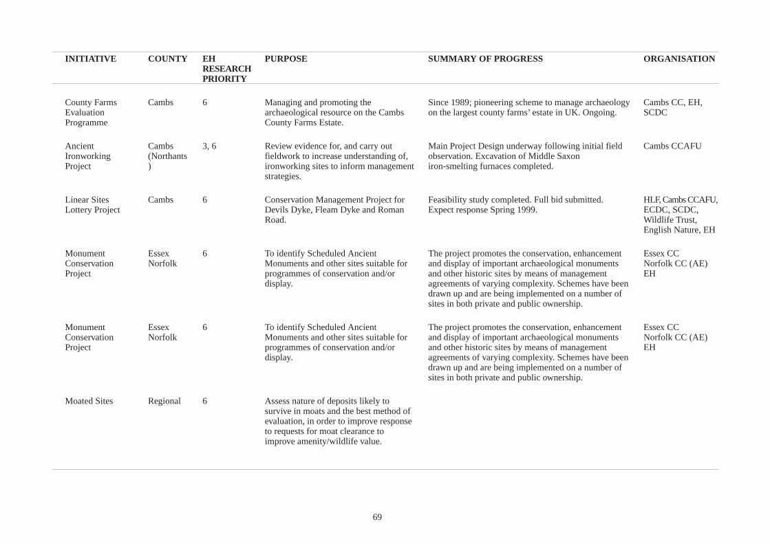
INITIATIVE COUNTY EH PURPOSE SUMMARY OF PROGRESS ORGANISATION RESEARCH PRIORITY
County Farms Cambs 6 Managing and promoting the Since 1989; pioneering scheme to manage archaeology Cambs CC, EH, Evaluation archaeological resource on the Cambs on the largest county farms’ estate in UK. Ongoing. SCDC Programme County Farms Estate.
Ancient Cambs 3, 6 Review evidence for, and carry out Main Project Design underway following initial field Cambs CCAFU Ironworking (Northants fieldwork to increase understanding of, observation. Excavation of Middle Saxon Project ) ironworking sites to inform management iron-smelting furnaces completed.
strategies.
Linear Sites Cambs 6 Conservation Management Project for Feasibility study completed. Full bid submitted. HLF, Cambs CCAFU, Lottery Project Devils Dyke, Fleam Dyke and Roman Expect response Spring 1999. ECDC, SCDC,
Road. Wildlife Trust, English Nature, EH
Monument Essex 6 To identify Scheduled Ancient The project promotes the conservation, enhancement Essex CC Conservation Norfolk Monuments and other sites suitable for and display of important archaeological monuments Norfolk CC (AE) Project programmes of conservation and/or and other historic sites by means of management EH
display. agreements of varying complexity. Schemes have been drawn up and are being implemented on a number of sites in both private and public ownership.
Moated Sites Regional 6 Assess nature of deposits likely to survive in moats and the best method of evaluation, in order to improve response to requests for moat clearance to improve amenity/wildlife value.
69

INITIATIVE COUNTY EH PURPOSE SUMMARY OF PROGRESS ORGANISATION RESEARCH PRIORITY
Education Essex, 2, 3, 6 To increase public awareness and Essex: this has proved very popular with schools, Colchester BC Programme Cambs understanding of the archaeological especially primary KS3. National Archaeology Record Office
heritage of Essex and Cambridgeshire weekend well- established at Gosbecks (Colchester and the work of the Archaeology Museums). Successful schools days run at Cressing Section. Temple. Cambs CC, AFU
Cambs: ongoing for several years; has proved very popular with schools especially at KS1 & 2. Adult education is undertaken in partnership with Cambridge University Board of Continuing Education and other providers; including evening classes, conferences and day schools.Annual Archaeological Training Excavation accredited by Cambridge University and CBA Mid Anglia.
Ramsey Abbey Cambs 2 To locate and investigate one of the Excavation of the outer court completed 1998. CCCAFU, SERC Science and foremost Anglo-Saxon and Medieval Geophysical survey, masonry survey and other Millennium award Archaeology Abbeys in the country. investigations continued during 1999. Schoolchildren Project from Ramsey Abbey and the Ailwyn schools closely
involved and have established a web-site.
70

Index
Illustrations are denoted by page numbers in italics.
aerial survey, 54, 60 afforestation, 2, 52, 53 agriculture
as research theme, 44-5, 57 Neolithic/Bronze Age, 9, 10-12; Iron Age, 14, 16, 17; Roman, 21; Anglo-Saxon/medieval, 25-6; post-medieval, 33, 42
as threat to resource, 2, 12, 15, 20, 23, 52, 53 see also field systems
ALGAO strategy, 55 Anglo-Saxon period
current initiatives, 59, 60, 65, 69, 70 research themes, 45 rural sites, 23-6 urban sites, 27-32 see also East Anglian Kingdom
Anglo-Scandinavian period, 24, 26, 30 animal bone studies, 44, 45
Palaeolithic/Mesolithic, 7 Neolithic/Bronze Age, 9, 10 Iron Age, 14, 16 Roman, 21 Anglo-Saxon/medieval, 25, 32 post-medieval, 33
Ant, river, 63 Antonine fires, 21 artefact studies
current initiatives, 65, 67 as research theme, 15, 16, 23, 45-6, 57
Aylesford/Swarling culture, 16
Baldock (Herts), 68 Barrington (Cambs)
bed burial, 24 parish survey, 66
barrows, 10, 61 Beacon Hill (Essex), 33 Bedfordshire, 1 Billericay (Essex), 68 Blackwater Estuary Archaeological Project, 66 Blakeney esker (Norfolk), 8 bone working, 32, 46 Bowaters Farm (Essex), 33 Bradwell (Norfolk), 22 Brampton (Cambs), 66 Brandon (Suffolk), 25, 26, 29, 54 brick and tile industries, 40 bridges, 21, 41, 63 Bronze Age period, 9-13, 17
current initiatives, 61, 65, 66 research themes, 44, 45
buildings medieva/post-medieval, 24-5, 29, 30, 65 post-medieval, military, 36 see also farmsteads; industrial archaeology
Bungay (Suffolk), 28 Burgh Castle (Norfolk), 20, 21, 22 burial practice
Neolithic/Bronze Age, 10 Iron Age, 16, 17 Roman, 19-20 Anglo-Saxon, 24, 46, 56 see also cemeteries; human bones
buried soils, 5, 14, 15, 16, 46-7 Burnham (Norfolk), 28 Bury St Edmunds (Suffolk), 28 Bytham see Ingham/Bytham river
Cam valley, 6 Cambridge (Cambs), 27, 60 Cambridgeshire County Farms Estate Survey, 52, 53, 69 canals, 40, 41, 62 Canvey Island (Essex), 32
Catuvellauni, 20 cemeteries
Iron Age, 17 Roman, 19, 21, 46 Anglo-Saxon, 23, 25 medieval, 46
Chelmsford (Essex), 29, 34 Chiltern Brickearths, 6 Christianity see churches; monasteries; religion chronologies
current initiatives, 65 Palaeolithic/Mesolithic, 5 Iron Age, 14, 16, 45 urban sites, 27-8, 30
churches, 26, 62, 64; see also monasteries claylands, 46 coastal areas
current initiatives, 57, 59, 61, 62, 66, 68 as research theme, 47, 52. 53
Palaeolithic/Mesolithic period, 6; Neolithic/Bronze Age period, 10; Roman period, 19, 21, 22; post-medieval period, 34, 35, 36
see also fisheries; ports; salt industry; shipwrecks Coddenham (Suffolk), 67 coins, 15, 16, 20 Colchester (Essex), 19, 21, 22, 27, 46, 60 communication, 51 conservation, 1-2, 52 Conservation Areas, 36 consultation, 1 copper alloy working, 9, 45 County Boundary Survey, 63 County Gardens Trusts, 37 Cressing (Essex), 39, 54, 65, 66, 70 cropmark sites
current initiatives, 53, 61 as research theme, 10, 12, 53, 56, 57
Crowland (Suffolk), 29 current initiatives, 51, 59-70
Debenham (Suffolk), 67 defences, post-medieval, 33-4, 35, 36, 63-4 demography see population studies dendrochronology, 65 deserted medieval villages, 23 development, as threat to resource, 2, 7, 52, 53 Devils Dyke (Cambs), 68, 69 DNA analysis, 23 documentary research, 33, 36, 37-8, 40, 62, 66 drainage, 7, 33 drove routes, 16 duck decoy ponds, 68 dyeing, 32, 46 dykes see linear boundaries
earthworks erosion, 52 survey, 62
East Anglian Kingdom, 23, 28, 47, 59 East Midlands, research framework, 1 Eastern Counties Regional Co-ordination Group, 1, 50 economy
Palaeolithic/Mesolithic, 5-6 Iron Age, 14 Anglo-Saxon, 23 urban sites, 31, 45
education, 2, 51, 70 Elveden (Suffolk), 67 Ely (Cambs), 28, 29 enclosure, agricultural, 33 enclosures, 10, 16, 17, 53, 56, 61, 68 English Heritage, 1, 2, 55
English Nature, 54 English Rivers Project, 5-6 Environment Agency, 54
71
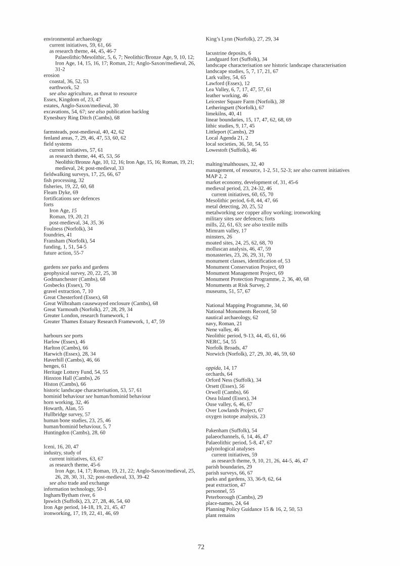
environmental archaeology current initiatives, 59, 61, 66 as research theme, 44, 45, 46-7
Palaeolithic/Mesolithic, 5, 6, 7; Neolithic/Bronze Age, 9, 10, 12; Iron Age, 14, 15, 16, 17; Roman, 21; Anglo-Saxon/medieval, 26, 31-2
erosion coastal, 36, 52, 53 earthwork, 52 see also agriculture, as threat to resource
Essex, Kingdom of, 23, 47 estates, Anglo-Saxon/medieval, 30 excavations, 54, 67; see also publication backlog Eynesbury Ring Ditch (Cambs), 68
farmsteads, post-medieval, 40, 42, 62 fenland areas, 7, 29, 46, 47, 53, 60, 62 field systems
current initiatives, 57, 61 as research theme, 44, 45, 53, 56
Neolithic/Bronze Age, 10, 12, 16; Iron Age, 15, 16; Roman, 19, 21; medieval, 24; post-medieval, 33
fieldwalking surveys, 17, 25, 66, 67 fish processing, 32 fisheries, 19, 22, 60, 68 Fleam Dyke, 69 fortifications see defences forts
Iron Age, 15 Roman, 19, 20, 21 post-medieval, 34, 35, 36
Foulness (Norfolk), 34 foundries, 41 Fransham (Norfolk), 54 funding, 1, 51, 54-5 future action, 55-7
gardens see parks and gardens geophysical survey, 20, 22, 25, 38 Godmanchester (Cambs), 68 Gosbecks (Essex), 70 gravel extraction, 7, 10 Great Chesterford (Essex), 68 Great Wilbraham causewayed enclosure (Cambs), 68 Great Yarmouth (Norfolk), 27, 28, 29, 34 Greater London, research framework, 1 Greater Thames Estuary Research Framework, 1, 47, 59
harbours see ports Harlow (Essex), 46 Harlton (Cambs), 66 Harwich (Essex), 28, 34 Haverhill (Cambs), 46, 66 henges, 61 Heritage Lottery Fund, 54, 55 Hinxton Hall (Cambs), 26 Histon (Cambs), 66 historic landscape characterisation, 53, 57, 61 hominid behaviour see human/hominid behaviour horn working, 32, 46 Howarth, Alan, 55 Hullbridge survey, 57 human bone studies, 23, 25, 46 human/hominid behaviour, 5, 7 Huntingdon (Cambs), 28, 60
Iceni, 16, 20, 47 industry, study of
current initiatives, 63, 67 as research theme, 45-6
Iron Age, 14, 17; Roman, 19, 21, 22; Anglo-Saxon/medieval, 25, 26, 28, 30, 31, 32; post-medieval, 33, 39-42
see also trade and exchange information technology, 50-1 Ingham/Bytham river, 6 Ipswich (Suffolk), 23, 27, 28, 46, 54, 60 Iron Age period, 14-18, 19, 21, 45, 47 ironworking, 17, 19, 22, 41, 46, 69
King’s Lynn (Norfolk), 27, 29, 34
lacustrine deposits, 6 Landguard fort (Suffolk), 34 landscape characterisation see historic landscape characterisation landscape studies, 5, 7, 17, 21, 67 Lark valley, 54, 65 Lawford (Essex), 12 Lea Valley, 6, 7, 17, 47, 57, 61 leather working, 46 Leicester Square Farm (Norfolk), 38 Letheringsett (Norfolk), 67 limekilns, 40, 41 linear boundaries, 15, 17, 47, 62, 68, 69 lithic studies, 9, 17, 45 Littleport (Cambs), 29 Local Agenda 21, 2 local societies, 36, 50, 54, 55 Lowestoft (Suffolk), 46
malting/malthouses, 32, 40 management, of resource, 1-2, 51, 52-3; see also current initiatives MAP 2, 2 market economy, development of, 31, 45-6 medieval period, 23, 24-32, 46
current initiatives, 60, 65, 70 Mesolithic period, 6-8, 44, 47, 66 metal detecting, 20, 25, 52 metalworking see copper alloy working; ironworking military sites see defences; forts mills, 22, 61, 63; see also textile mills Mimram valley, 17 minsters, 26 moated sites, 24, 25, 62, 68, 70 molluscan analysis, 46, 47, 59 monasteries, 23, 26, 29, 31, 70 monument classes, identification of, 53 Monument Conservation Project, 69 Monument Management Project, 69 Monument Protection Programme, 2, 36, 40, 68 Monuments at Risk Survey, 2 museums, 51, 57, 67
National Mapping Programme, 34, 60 National Monuments Record, 50 nautical archaeology, 62 navy, Roman, 21 Nene valley, 46 Neolithic period, 9-13, 44, 45, 61, 66 NERC, 54, 55 Norfolk Broads, 47 Norwich (Norfolk), 27, 29, 30, 46, 59, 60
oppida, 14, 17 orchards, 64 Orford Ness (Suffolk), 34 Orsett (Essex), 56 Orwell (Cambs), 66 Osea Island (Essex), 34 Ouse valley, 6, 46, 67 Over Lowlands Project, 67 oxygen isotope analysis, 23
Pakenham (Suffolk), 54 palaeochannels, 6, 14, 46, 47 Palaeolithic period, 5-8, 47, 67 palynological analyses
current initiatives, 59 as research theme, 9, 10, 21, 26, 44-5, 46, 47
parish boundaries, 29 parish surveys, 66, 67 parks and gardens, 33, 36-9, 62, 64 peat extraction, 47 personnel, 55 Peterborough (Cambs), 29 place-names, 24, 64 Planning Policy Guidance 15 & 16, 2, 50, 53 plant remains
72

current initiatives, 59 as research theme, 44, 45
Neolithic/Bronze Age, 9, 10; Iron Age, 14, 16; Roman, 21; Anglo-Saxon/medieval, 25, 26, 32; post-medieval, 33
Pleistocene deposits, 5-6 ploughing see agriculture, as threat to resource pollen analyses see palynological analyses Poor Law buildings, 41 population studies, 25, 29-30 Portable Antiquities Scheme, 52, 64 ports
Roman, 19, 21, 22 Anglo-Saxon/post-medieval, 23, 28, 29, 41, 46, 60
post-medieval period, 27-32, 33-43, 45, 46 potteries, 40 pottery
current initiatives, 65 as research theme, 45, 46
Neolithic/Bronze Age, 9, 10, 11, 12; Iron Age, 14-15, 16, 17; Roman, 19, 21; Anglo-Saxon/medieval, 23, 25, 26, 27-8
project design, 50 property boundaries, 29 publication backlog, 26, 28, 54, 68
radiocarbon dating, 16, 23, 26, 46 railways, 41 Ramsey Abbey (Cambs), 29, 70 Redgrave (Suffolk), 67 religion
Iron Age, 17 Roman, 20 Anglo-Saxon/medieval, 23, 26, 29, 30, 31 see also burial practice; cemeteries; churches; monasteries
research, 1-2 management, 52-3 priorities, 51-2 pro-active, 54 themes, 44-8, 57 threat-led, 53-4
Resource Assessment, 1, 2 review, 54, 55 ring-ditches, 56 rivers, 6, 41, 47 roads, Roman, 21, 22, 63, 69 Roman period, 19-22, 45, 46, 65, 67, 68 royal vills, 23, 30 Rural White Paper, 52
St Albans (Herts), 27, 60 salt industry, 17, 19, 22, 68 Science-based Archaeology Strategy Group, 51 Sedgeford (Norfolk), 54, 65 sediment analyses see soil and sediment analyses settlement sites/settlement patterns, as research theme, 44, 57
Neolithic/Bronze Age, 9-10, 12 Iron Age, 14, 15, 16, 17 Roman, 19, 20, 21, 22 Anglo-Saxon/medieval, 23-4, 25, 26, 29 industrial, 41, 42
shipwrecks, 22, 60, 62 Shoeburyness (Essex), 36 Shudy Camps (Cambs), 66 Sites and Monuments Records
current initiatives, 65, 68 inadequacies, 33, 36, 37, 39, 41 research strategy, 50-1, 54, 57
social organisation, 17, 30-1 soil and sediment analysis, 10, 16, 46, 47, 59; see also buried soils Southchurch Hall moated site (Essex), 68 Southend Municipal Hospital (Essex), 41 Stansted (Essex), 46, 59 status, definition of, 30 steam engine houses, 40 Stoke by Nayland (Suffolk), 67 Stonea Camp (Cambs), 15 Stour valley, 12, 57, 61 Stow Maries (Essex), 33 Stratton (Beds), 46 streets, medieval, 29 submerged forests, 10 Suffolk Broads, 47 survey, 46-7, 54 Sutton Hoo (Suffolk), 54
Tas valley, 17 territorial boundaries, 30; see also linear boundaries; parish boundaries; tribal/territorial regions textile industry, 32, 46 textile mills, 40 Thames valley, 6, 7, 22, 47, 59, 61 thermoluminescence, 16 Thorney (Cambs), 29 Thriplow (Cambs), 67 Tilbury (Essex), 34 tourism, 2 towns
current initiatives, 60, 69 as research theme, 45, 54
Roman, 21; Anglo-Saxon/post-medieval, 27-32 see also urban development
trackways, 10, 12, 16, 19, 56 trade and exchange, 14, 17, 29, 30, 31, 45-6, 54, 60; see also industry tribal/territorial regions, 16, 20, 23, 47, 54 Trinovantes, 20, 21, 47
Urban Archaeological Databases, 27, 52, 60 urban development, 23-4, 27-8, 29-31, 45, 57
villages, 23, 25, 62, 69 villas, Roman, 19
Walton-on-Naze (Essex), martello tower, 35 wartime defences see defences, post-medieval waterlogged sites, 47 Waveney valley, 25, 46, 67 Welland valley, 46 West Row (Suffolk), 54 West Stow (Suffolk), 67 Westacre (Norfolk), 66 Wicken Bonhunt (Essex), 25, 26 Wisbech (Cambs), 27, 28, 29 woodland, 15, 19, 21, 24, 26, 63; see also afforestation woodland management, 10, 14, 65 World War II Defences Survey, 63
73

If you would like this document in a different format, please contact our Customer Services department: Telephone: 0870 333 1181 Fax: 01793 414926 Textphone: 01793 414878 E-mail: [email protected]